site plan recommendation and conditions · site plan recommendation and conditions . ... exterior...
TRANSCRIPT
7
2
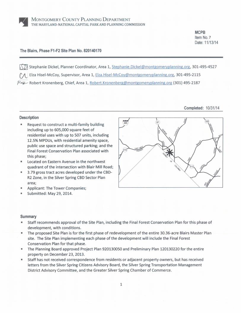
SITE PLAN RECOMMENDATION AND CONDITIONS Staff recommends approval, with conditions, of Site Plan 820140170, for construction of a multi-family building including up to 605,000 square feet of residential uses consisting of a maximum of 507 units, on 3.79 gross tract acres developed under the standards of the CBD-R2 Zone, as well as the Final Forest Conservation Plan associated with this phase. All site development elements shown on the latest electronic version as of the date of this Staff Report submitted via ePlans to the M-NCPPC are required except as modified by the following conditions:1 Conformance with Previous Approvals
1. Project Plan Conformance The development must comply with the conditions of approval for Project Plan 920130050, as listed in MCPB Resolution No. 13-109 dated December 23, 2013, as amended.
2. Preliminary Plan Conformance The development must comply with the conditions of approval for Preliminary Plan 120130220, as listed in MCPB Resolution No. 13-110 dated December 23, 2013, as amended.
Environment
3. Forest Conservation a) The Final Forest Conservation Plan approved with this Site Plan, as conditioned below, is
limited to the portion of the larger Blairs Master Plan site covered by this Site Plan, and does not cover the remainder of Preliminary Forest Conservation Plan 120130220. Future Site Plan approvals for implementation of subsequent phases of the larger site will address the remaining forest conservation requirements associated with future phases and will include a Final Forest Conservation Plan for those phases.
b) Before Certified Site Plan approval, the Applicant will coordinate with Staff on any necessary minor plan revisions, clarifications and corrections within the Final Forest Conservation Plan signature set.
c) The Applicant must include three (3) additional 3” caliper native canopy tree plantings in the Final Forest Conservation Plan(s) of the future phase(s).
d) Before issuance of an associated Sediment Control Permit, the Applicant must receive approval from the M-NCPPC Office of the General Counsel for a Certificate of Compliance for an off-site forest mitigation bank, to satisfy the equivalent credits of 1.17 acres or as established with the Final Forest Conservation Plan for this Site Plan.
4. Stormwater Management The Planning Board accepts the recommendations of the Montgomery County Department of Permitting Service (MCDPS) Water Resources Section in its stormwater management concept letter dated September 10, 2014, and hereby incorporates them as conditions of approval for this Site Plan. The Applicant must comply with each of the recommendations as set forth in the letter, which MCDPS Water Resources Section may amend if the amendments do not conflict
1 For the purposes of these conditions, the term “Applicant” shall also mean the developer, the owner or any successor (s) in
interest to the terms of this approval.
3
with other conditions of the Site Plan approval. MCDPS Water Resources Section will review, approve, and inspect all landscaping within the Storm Water Management easements and facilities.
Public Use Space, Facilities and Amenities
5. Public Use Space, Facilities, and Amenities a) The Applicant must provide a minimum of 48,000 square feet of public use space (29.6% of
the 3.71 acres-net lot area of this Site Plan) on-site. This represents 20.6% of the entire 232,000 square feet of public use space required on the Blairs Master Plan site.
b) Before the issuance of the final use and occupancy certificate for the residential development for each phase of this Site Plan, public use space areas associated with each phase of the must be completed.
6. Recreation Facilities
a) Before the issuance of the final use and occupancy certificate for the residential development for each phase of this Site Plan, the Applicant must provide the recreational elements associated with each phase in accordance with the approved Montgomery County Planning Board Recreation Guidelines, as described below.
b) The Applicant must provide the following minimum recreation facilities for this Site Plan: i. 16 Picnic/Sitting Areas;
ii. Pedestrian System; iii. 1 Swimming Pool; iv. 1 Indoor Community Space for Residents; and v. 1 Indoor Fitness Facility.
7. M-NCPPC Department of Parks
a) The Applicant must provide clear signage that the Dog Run is available to the public and not just residents of The Blairs.
b) In conjunction with the next site plan submittal, the Applicant shall provide a survey to the Department of Parks of how the Dog Run patrons are arriving and where they are parking.
8. Maintenance of Public Amenities The Applicant is responsible for maintaining all publicly accessible amenities including, but not limited to, pedestrian pathways, landscaping, hardscape, recreation facilities, and public use space.
Transportation & Circulation
9. Transportation a) The Applicant must enter into a Traffic Mitigation Agreement (TMAg) with the Planning
Board and the Montgomery County Department of Transportation (MCDOT) to participate in the Silver Spring Transportation Management District (TMD). The Applicant must execute the TMAg before the release of any above grade building permit for the proposed development.
b) The Applicant, as part of the TMAg or separately, must coordinate with the MCDOT Chief of Commuter Services to install a Capital Bikeshare station on the Blairs Master Plan site at a

4
location and at a time mutually agreed upon between the Applicant and the County. The location of the bikeshare station must be finalized in writing by the MCDOT Chief of Commuter Services before the release of any above grade building permit for development on the site within this Site Plan. The access and maintenance agreement for the bikeshare station must be finalized as part of the certified site plan for the project phase that includes a bikeshare station.
c) The Applicant must construct the private internal street(s) within this Site Plan to applicable Montgomery County MCDOT Road Code Standard 2005.01 Modified: Two Lane Business District Street structural standards and must construct all sidewalks, on the Subject Property within this Site Plan, to applicable ADA standards. Before the release of bond or surety, the Applicant must provide MCDPS Zoning & Site Plan Enforcement (Z&SPE) Staff with certification from a licensed engineer that all streets and sidewalks have been built to the above structural standards and ADA standards.
d) Before issuance of the first above grade building permit, the Applicant must receive a District of Columbia (DC) Department of Transportation (DDOT) Public Space Permit and DC Public Space Committee approval for all DC right-of-way improvements within Eastern Avenue, NW. A copy of the permit must be provided to M-NCPPC Staff and MCDPS.
10. Pedestrian and Bicycle Circulation
a) The Applicant must provide a minimum of 136 private and 17 public bicycle parking spaces. b) The secure private long-term bicycle parking spaces must be installed internal to the
residential building or garage for the residents’ use. The public bicycle spaces must be inverted-U racks, or similar approved by M-NCPPC Staff at Certified Site Plan and installed in a location convenient to the main entrance. The specific locations of the public bicycle racks must be identified on the Certified Site Plan.
c) The Applicant must provide minimum 5-foot wide sidewalks along the private streets. d) The Applicant must provide improvements as approved by the DC Public Space Committee
along the frontage of public street Eastern Avenue, NW.
11. Fire and Rescue The Planning Board accepts the recommendations of the Montgomery County Fire and Rescue Services (MCFRS) Fire Code Enforcement Section in its letter dated August 6, 2014, and hereby incorporates them as conditions of approval for this Site Plan. The Applicant must comply with each of the recommendations as set forth in the letter, which MCFRS Fire Code Enforcement Section may amend provided that the amendments do not conflict with other conditions of Site Plan approval.
Density and Housing
12. Moderately Priced Dwelling Units (MPDUs) a) The Planning Board accepts the recommendations of the Department of Housing and
Community Affairs (DHCA) in its letter dated October 10, 2014, and hereby incorporates them as conditions of approval. The Applicant must comply with each of the recommendations as set forth in the letter, which DHCA may amend provided that the amendments do not conflict with other conditions of Site Plan approval.
b) Before issuance of any above grade building permit for residential units, the MPDU agreement to build between the Applicant and DHCA must be executed.

5
Site Plan
13. Building Height The maximum height for the F1-F2 building is 180 feet, as measured from the building height measuring point located on the eastern corner of the Site along Street C.
14. Site Design The exterior architectural character, proportion, materials, and articulation must be substantially similar to the schematic elevations shown on the latest approved architectural drawings included in the Certified Site Plan, as determined by M-NCPPC Staff.
15. Landscaping
a) Before issuance of the final residential use and occupancy certificate for the first phase of the Site Plan, all on-site amenities including, but not limited to, streetlights, sidewalks/pedestrian pathways, hardscape, benches, trash receptacles, bicycle facilities, recreation amenities (including the swimming pool and indoor community space for the residents, pedestrian system and picnic/seating areas), and public use space amenities within the phase must be installed.
b) Before issuance of the final residential use and occupancy certificate for the second phase of the Site Plan, all on-site amenities including, but not limited to, streetlights, sidewalks/pedestrian pathways, hardscape, benches, trash receptacles, bicycle facilities, recreation amenities (including the indoor community space for the residents, pedestrian system and picnic/seating areas), and public use space amenities within the phase must be installed.
c) The Applicant must install the landscaping associated with each phase no later than the next growing season after completion of each phase and site work.
16. On-Site Lighting
a) Before issuance of any above-grade building permit, the Applicant must provide certification to M-NCPPC Staff from a qualified professional that the exterior lighting in this Site Plan conforms to the latest Illuminating Engineering Society of North America (IESNA) recommendations (Model Lighting Ordinance-MLO: June 15, 2011) for a development of this type. All onsite exterior area lighting must be in accordance with the latest IESNA outdoor lighting recommendations (Model Lighting Ordinance-MLO: June 15, 2011).
b) Deflectors must be installed on all proposed up-lighting fixtures to prevent excess illumination and glare.
c) Illumination levels generated from on-site lighting must not exceed 0.5 footcandles (fc) at any property line abutting public roads and residentially developed properties.
d) Streetlights and other pole-mounted lights must not exceed the height illustrated on the Certified Site Plan.
e) On the rooftop of the building, the light pole height must not exceed the height illustrated on the Certified Site Plan.
17. Site Plan Surety and Maintenance Agreement
Before issuance of any above grade building permit within each relevant phase of this Site Plan, the Applicant must enter into a Site Plan Surety and Maintenance Agreement with the Planning Board. The Agreement must include a performance bond(s) or other form of surety as required
6
by Section 59-D-3.5(d) of the Montgomery County Zoning Ordinance, with the following provisions: a) A cost estimate of the materials and facilities, which, upon M-NCPPC Staff approval, will
establish the surety amount. b) The cost estimate must include applicable Site Plan elements, including, but not limited to
plant material, on-site lighting, recreational facilities, site furniture, mailbox pad sites, trash enclosures, retaining walls, fences, railings, private roads, paths and associated improvements within the relevant phase of development.
c) The bond or surety must be tied to the development program, and completion of all improvements covered by the surety for each phase of development will be followed by inspection and potential reduction of the surety.
d) The bond or surety for each phase shall be clearly described within the Site Plan Surety & Maintenance Agreement including all relevant conditions and specific Certified Site Plan sheets depicting the limits of each phase.
18. Development Program
Before approval of the Certified Site Plan, the Applicant will provide the development in accordance with a development program that will be reviewed and approved by M-NCPPC Staff. The development program must include the following items in the phasing schedule: a) The Applicant may apply for and obtain demolition and associated rough grading permits at
any time. b) Clearing and grading must correspond to the construction phasing to minimize soil erosion
and must not occur before approval of the Final Forest Conservation Plan, Sediment Control Plan, and Staff inspection and approval of all applicable environmental protection devices.
c) Providing on-site amenities including, but not limited to, streetlights, sidewalks/pedestrian pathways, private internal streets, hardscape, benches, trash receptacles, bicycle facilities, recreation amenities, and public use space amenities located within each phase of the Site Plan.
d) Installation of on-site landscaping and lighting located within each phase of the Site Plan. e) Dedications, stormwater management, sediment and erosion control, afforestation, and
other features, as applicable, located within each phase of the Site Plan.
19. Certified Site Plan Before approval of the Certified Site Plan, the following revisions must be made and/or information provided subject to M-NCPPC Staff review and approval: a) Include the Final Forest Conservation Plan approval letter, stormwater management
concept approval letter, development program, and the Project, Preliminary, and Site Plan resolutions on the approval or cover sheet(s).
b) Add a note to the Site Plan stating that “M-NCPPC Staff must inspect all tree-save areas and protection devices before clearing and grading”.
c) Modify data table to reflect development standards as approved by the Planning Board. d) Ensure consistency of all details and layout between Site and Landscape plans.
20. Permit Filing and Processing
a) The Applicant may file the application for record plat approval at any time after filing the Certified Site Plan Application for approval with M-NCPPC Staff.
7
b) The Applicant may apply for foundation-to-grade and sheeting and shoring permits with MCDPS at any time after both the Certified Site Plan application and record plat application have been filed with M-NCPPC Staff.
c) DPS is authorized by the Planning Board to issue foundation-to-grade and sheeting and shoring permits at any time after obtaining Certified Site Plan approval and the new record plat application has been filed, regardless of whether the new record plat application has been approved or the plat recorded. The Applicant may commence work under those permits once they are issued.
d) Any above grade building permit may not be issued until after the record plat has been approved and recorded.
e) The Applicant shall pay the full building permit fee for each phase as part of the foundation-to-grade permit for that phase.

8
SITE DESCRIPTION Vicinity The 3.79 gross acres Subject Property encompassing the F1 & F2 Blocks of the site is located on Eastern Avenue NW, in the northwest quadrant of the intersection with Blair Mill Road (Subject Property or Property). The entire 30.36-acre Blairs Master Plan site (entire site) is located within the Silver Spring Central Business District (CBD) in the eastern quadrant of the intersection of Colesville Road (MD 384) and Eastern Avenue NW. The entire site is bounded on the northwest by Colesville Road, on the south by Blair Mill Road, on the northeast by East-West Highway, and on the southwest by Eastern Avenue NW. The entire site is governed by the 2000 Silver Spring CBD Sector Plan. The closest distance to the Silver Spring Metrorail station is approximately 500 feet from an existing entry point along East West Highway. (Figure 1)
Figure 1-Vicinity Map
Entire Site boundary line Subject Property boundary line
9
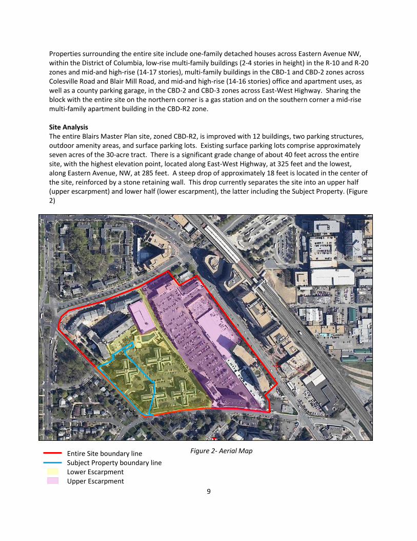
Properties surrounding the entire site include one-family detached houses across Eastern Avenue NW, within the District of Columbia, low-rise multi-family buildings (2-4 stories in height) in the R-10 and R-20 zones and mid-and high-rise (14-17 stories), multi-family buildings in the CBD-1 and CBD-2 zones across Colesville Road and Blair Mill Road, and mid-and high-rise (14-16 stories) office and apartment uses, as well as a county parking garage, in the CBD-2 and CBD-3 zones across East-West Highway. Sharing the block with the entire site on the northern corner is a gas station and on the southern corner a mid-rise multi-family apartment building in the CBD-R2 zone. Site Analysis The entire Blairs Master Plan site, zoned CBD-R2, is improved with 12 buildings, two parking structures, outdoor amenity areas, and surface parking lots. Existing surface parking lots comprise approximately seven acres of the 30-acre tract. There is a significant grade change of about 40 feet across the entire site, with the highest elevation point, located along East-West Highway, at 325 feet and the lowest, along Eastern Avenue, NW, at 285 feet. A steep drop of approximately 18 feet is located in the center of the site, reinforced by a stone retaining wall. This drop currently separates the site into an upper half (upper escarpment) and lower half (lower escarpment), the latter including the Subject Property. (Figure 2)
Entire Site boundary line Subject Property boundary line Lower Escarpment Upper Escarpment
Figure 2- Aerial Map
10
Existing commercial development on the upper escarpment includes a 72,562- square-foot office building and 85,196 square feet of retail and restaurant uses, which includes a 54,000 square-foot Giant Foods grocery store. Existing residential development there includes two high-rise residential buildings, Blair East and Blair Plaza. A three-story parking structure sits behind Blair East next to the Giant Foods grocery store. The lower escarpment consists entirely of residential buildings: Blair Towers, Blair House, and the Blair Towns. A parking structure that serves both Blair House and Blair Towns is located at the rear of the two buildings on the interior of the site. Surface parking and an outdoor swimming pool for residents of The Blairs is located next to this parking garage on the interior of the site. A total of 13 curb cuts are located along the perimeter of the site for vehicular access to the interior. The Subject Property is located on part of the site of the Blair Towers, a multi-family residential development, constructed in 1959. The Blair Towers development consists of four separate five-story multi-family residential buildings, containing a total of 267 dwelling units. Significant and specimen sized trees are located within and adjacent to the Application’s boundaries. There is no forest, streams, buffers, or rare, threatened, or endangered species on the Subject Property.
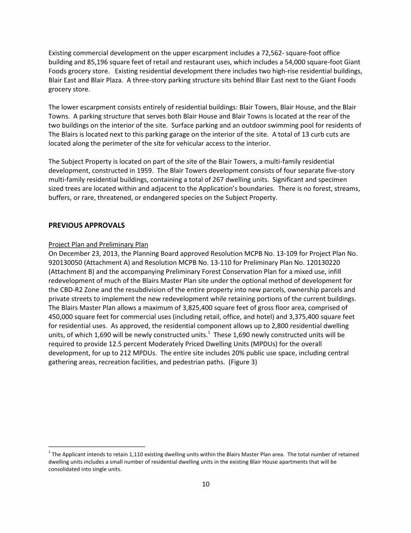
PREVIOUS APPROVALS Project Plan and Preliminary Plan On December 23, 2013, the Planning Board approved Resolution MCPB No. 13-109 for Project Plan No. 920130050 (Attachment A) and Resolution MCPB No. 13-110 for Preliminary Plan No. 120130220 (Attachment B) and the accompanying Preliminary Forest Conservation Plan for a mixed use, infill redevelopment of much of the Blairs Master Plan site under the optional method of development for the CBD-R2 Zone and the resubdivision of the entire property into new parcels, ownership parcels and private streets to implement the new redevelopment while retaining portions of the current buildings. The Blairs Master Plan allows a maximum of 3,825,400 square feet of gross floor area, comprised of 450,000 square feet for commercial uses (including retail, office, and hotel) and 3,375,400 square feet for residential uses. As approved, the residential component allows up to 2,800 residential dwelling units, of which 1,690 will be newly constructed units.1 These 1,690 newly constructed units will be required to provide 12.5 percent Moderately Priced Dwelling Units (MPDUs) for the overall development, for up to 212 MPDUs. The entire site includes 20% public use space, including central gathering areas, recreation facilities, and pedestrian paths. (Figure 3)
1 The Applicant intends to retain 1,110 existing dwelling units within the Blairs Master Plan area. The total number of retained
dwelling units includes a small number of residential dwelling units in the existing Blair House apartments that will be consolidated into single units.
11
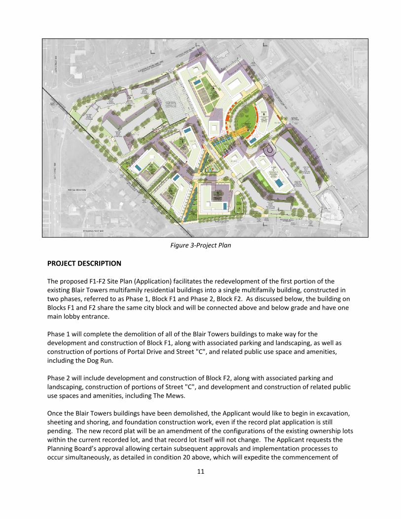
Figure 3-Project Plan
PROJECT DESCRIPTION The proposed F1-F2 Site Plan (Application) facilitates the redevelopment of the first portion of the existing Blair Towers multifamily residential buildings into a single multifamily building, constructed in two phases, referred to as Phase 1, Block F1 and Phase 2, Block F2. As discussed below, the building on Blocks F1 and F2 share the same city block and will be connected above and below grade and have one main lobby entrance. Phase 1 will complete the demolition of all of the Blair Towers buildings to make way for the development and construction of Block F1, along with associated parking and landscaping, as well as construction of portions of Portal Drive and Street "C", and related public use space and amenities, including the Dog Run. Phase 2 will include development and construction of Block F2, along with associated parking and landscaping, construction of portions of Street "C", and development and construction of related public use spaces and amenities, including The Mews. Once the Blair Towers buildings have been demolished, the Applicant would like to begin in excavation, sheeting and shoring, and foundation construction work, even if the record plat application is still pending. The new record plat will be an amendment of the configurations of the existing ownership lots within the current recorded lot, and that record lot itself will not change. The Applicant requests the Planning Board’s approval allowing certain subsequent approvals and implementation processes to occur simultaneously, as detailed in condition 20 above, which will expedite the commencement of
12
construction and the completion of the first phase of the Blairs Master Plan, as detailed in their Request for Permit Filing and Processing (Attachment C). The Application covers 3.71 net lot acres of land for development (3.79 gross tract acres), however due to the demolition of all four of the Blair Tower buildings, for forest conservation purposes, the limits of disturbance is greater (see Forest Conservation Plan discussion, page 20). The multifamily residential building that is proposed in Phases 1 and 2 provides a maximum of 507 total units, requiring 64 MPDUs (12.5 percent) within the development. The final unit mix will be confirmed at Certified Site Plan and the locations of the required MPDUs will be established in accordance with applicable requirements of the Montgomery County Department of Housing and Community Affairs (DHCA).
Site Design and Architecture At the time of Project Plan approval, the Applicant’s proposal included two buildings, one in Block F1 and one in Block F2, featuring two to four story-parking garages lined with townhouses, and residential towers on the top of these podiums. (Figure 5) The roof level of each podium would provide the area for private green space for the residents of each tower. Concerned about the close proximity of these proposed buildings, as well as those in Block G, to existing lower-scale garden apartment buildings and single-family houses across Eastern Avenue NW, the Project Plan called for compatibility to be re-examined as part of future Site Plan reviews.
Figure 4-Illustrative Construction Staging and Interim Conditions Plan
Future site of Building G Construction Staging and
Parking/Interim Use
Future site of Building E Temporary Green/Interim Use
BUILDING F1-F2
Dog Run
The Mews
Subject Property Limits of Disturbance

13
Figure 5-Project Plan Illustration for Block F1 and F2
Under this Application, the Applicant has revised the design to improve compatibility with existing surrounding development while improving connections within and through the development. Discussed in greater detail below, the Applicant has improved compability by breaking the building massing into three stepped sections that increase in height as they move from Eastern Avenue NW, into the site. The Applicant has improved access and connectivity and at the same time, the quality of open space by burying the parking garages. Building Massing and Compatibility This Application proposes a single new building, to be constructed in two phases, but interconnected above and below grade. The building includes two “U”-shaped wings oriented around two central private courtyards divided by a publicly-accessible through-block, The Mews, discussed below. The sections of the building along Private Street C connect over The Mews via an elevated enclosed walkway at the second floor, so that the public can move through the building forms and the green areas, visually enjoying the private green areas as they use the public ones. Many of the street/ground-level units along Eastern Avenue, the private courtyards, and the public through-block connections have private exterior entrances. The main lobby entrance is located along Private Street C, but private access points are also provided from the private courtyards.
14
Figure 6-Illustrative aerial, looking northwest
The Phase 1 building (on Block F1) will provide 283 residential dwelling units, with 36 MPDUs. Phase 2 (on Block F2) contains 224 additional residential dwelling units with 28 MPDUs, with the final unit counts in each phase to be determined at Certfied Site Plan. The combined building provides two levels of below-grade parking that will be connected at full build-out. (Figure 6) To improve compatibility, the building design for the F1 & F2 Blocks uses a three-tiered massing approach that places the lowest building height and density along Eastern Avenue, where the building volumes are modest five-story apartments with private entrance stoops, and increase in scale and height as one moves north through the Property stepping away from Eastern Avenue, with the tallest massing moved to the interior of the site along Private Street C . (Figure 7) This allows the building architecture to respond to the scale of the single-family homes across Eastern Avenue while simultaneously building upward to respond to the scale of future phases of the Blairs Master Plan to the northeast. (Figure 8) Additionally, along Eastern Avenue part of the fifth floor is set back approximately four (4) feet from the edge of the floor below, further reducing its visibility and enhancing the appearance as a four-story building, and the building edge was moved back to allow for additional plantings to create more residential-scale interest along the streetscape.
15
Figure 7-Illustrative Elevation along Eastern Avenue
Figure 8-Illustrative five-story perspective (looking into The Mews from Eastern Avenue)
16
The middle segments of the multi-family building are oriented generally perpendicular to Eastern Avenue and present their short faces to the street at seven stories in height. The form turns parallel to Eastern Avenue at approximately 200 feet away and steps up to maximums of 14 stories (for the Phase 1 building) and 18 stories (for the Phase 2 addition) along Street C on the northern side of the Property, with a maximum height of 180 feet. The building facades will utilize a mix of glazing and masonry with balconies to provide visual interest. The stepped portions of the building will have flat roofs to provide elevated exterior amenity spaces, including private open spaces for building residents, an outdoor swimming pool and a community garden, as well as providing locations for green roofs and screened mechanical equipment. Enhanced Connectivity The second major design revision lowered the parking garage from two floors of above- grade parking to two floors below grade, allowing a more efficient combined garage layout that will be connected underground. As a result, the Applicant was able to lower the private courtyard uses that were originally on top of the parking decks to grade, which allows for better pedestrian movement through the site amenities and public spaces: the private courtyands and The Mews. The stepped massing allows for maximum southern solar exposure into The Mews pedestrian pathway and the interior building courtyards, while also maximizing views of Rock Creek Park for the residents. The lobby and private amenity spaces will open up visually onto The Mews passageway located between Block F1 and Block F2, which will help activate the courtyards.
Figure 9-Illustrative perspective (Portal Drive and Eastern Avenue)
17
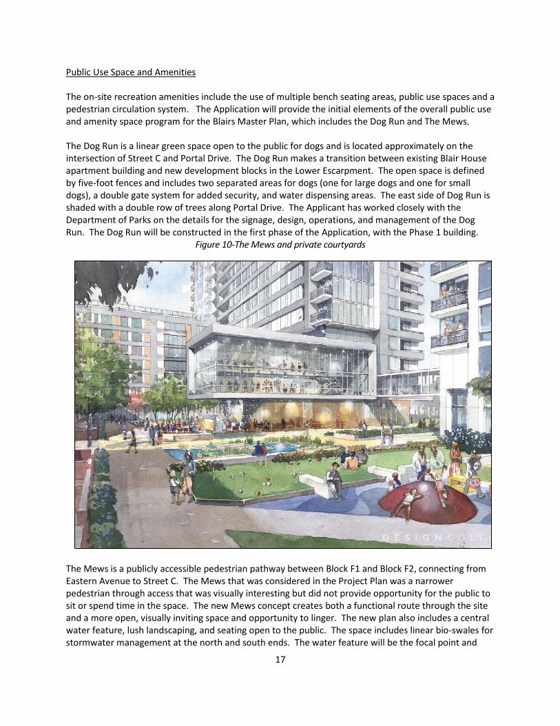
Public Use Space and Amenities The on-site recreation amenities include the use of multiple bench seating areas, public use spaces and a pedestrian circulation system. The Application will provide the initial elements of the overall public use and amenity space program for the Blairs Master Plan, which includes the Dog Run and The Mews. The Dog Run is a linear green space open to the public for dogs and is located approximately on the intersection of Street C and Portal Drive. The Dog Run makes a transition between existing Blair House apartment building and new development blocks in the Lower Escarpment. The open space is defined by five-foot fences and includes two separated areas for dogs (one for large dogs and one for small dogs), a double gate system for added security, and water dispensing areas. The east side of Dog Run is shaded with a double row of trees along Portal Drive. The Applicant has worked closely with the Department of Parks on the details for the signage, design, operations, and management of the Dog Run. The Dog Run will be constructed in the first phase of the Application, with the Phase 1 building.
Figure 10-The Mews and private courtyards
The Mews is a publicly accessible pedestrian pathway between Block F1 and Block F2, connecting from Eastern Avenue to Street C. The Mews that was considered in the Project Plan was a narrower pedestrian through access that was visually interesting but did not provide opportunity for the public to sit or spend time in the space. The new Mews concept creates both a functional route through the site and a more open, visually inviting space and opportunity to linger. The new plan also includes a central water feature, lush landscaping, and seating open to the public. The space includes linear bio-swales for stormwater management at the north and south ends. The water feature will be the focal point and
18
seating oriented to the water feature will be provided. (Figure 10) The Mews is proposed in the second phase of the Application, with the construction of the Phase 2 addition. The proposed public use space also includes green spaces with plantings, shaded areas with deciduous trees, and hardscape pedestrian areas with a variety of paving treatments. The Applicant is proposing to provide art/sculptural pieces with this Application. One art/sculptural piece will be generally located within the Mews in the form of a water feature and a second art/sculptural piece shall be located near main lobby. The final locations of these pieces located inside of the limits of this Application will be determined when the pieces have been commissioned or purchased. The Application will also provide private active/passive recreational space, including the landscaped courtyards, street level spaces as well as the rooftop amenity areas. The proposed building provides indoor community rooms and amenities including an indoor/outdoor patio, a swimming pool and fitness facility. Private amenity areas will be separated from the publicly accessible Mews by a gated fence. Sector Plan and Design Guidelines Conformance The approved Project Plan and Preliminary Plan were found by the Planning Board to be consistent with the 2000 Approved and Adopted Silver Spring CBD Sector Plan. The Application complies with the specific density recommendations for the site as well as the applicable urban design, roadway, and general recommendations outlined in the Sector Plan. Moderately Priced Dwelling Units (MPDUs) The proposed multifamily building provides a maximum of 507 units, requiring 64 MPDUs (12.5 percent). Of the 64 required MPDUs , 80 percent (51 MPDUs) will be provided in existing buildings in the Blairs complex that are included in the Preliminary Plan for the entire Blairs Master Plan site. The remaining 20 percent (13 MPDUs) will be provided in the new development. Allowing 80 percent of the required 64 MPDUs to be located in existing buildings at The Blairs results in the following dispersement:
The MPDU program will receive three (3) more two-bedroom units than would be required otherwise, and three (3) three-bedroom MPDUs, which the Applicant would not need to provide otherwise. Three-bedroom rental units are extremely rare in the Silver Spring submarket, and affordable three-bedroom rental units are rarer still.
Because most of the Blairs complex was constructed prior to adoption of Chapter 25A, only 10 MPDUs are currently located in The Blairs. Therefore, locating 51 MPDUs in the existing buildings will not result in an over-concentration of MPDUs.
The MPDUs in the existing buildings will average 85 square feet larger than MPDUs in the new development, and the units in the existing buildings have been recently renovated.
The MPDUs in the existing buildings will be made available two to three years earlier than the MPDUs in the new development.
The Applicant has worked closely with the Department of Housing and Community Affairs on the details of the MPDU agreement.
19
Proposed Vehicular Circulation & Parking The Application is part of a larger parcel approved via Preliminary Plan 120130220, which included multiple vehicular access points on Colesville Road, Blair Mill Road, East-West Highway, and Eastern Avenue, NW. Building F1-F2, proposed under the current application, will be accessed via two new internal private streets: Street C and Portal Drive. These proposed streets will be partially constructed as part of this phase of development and will connect with the surrounding public roadways via existing driveways on Blair Mill Road and Eastern Avenue, NW, respectively. Pedestrian and bicycle access to the Property will be provided on all frontages and internal roadways.
Parking will be provided through a combination of a below grade garage and on-street spaces, both of which will be accessed from the two new private streets. The loading and service areas for the proposed building is consolidated with the garage entrance on Portal Drive and to the east of the Mews pedestrian crosswalk on Street C, both of which are located away from prime pedestrian areas and building entrances.
Available Transit Service The immediate area is well served by transit that includes the Red Line Silver Spring Metrorail Station (located approximately 1,500 feet from the location of the F1-F2 building), Metrobus, RideOn bus, and the Silver Spring VanGo Circulator. Future transit in the area includes a proposed Purple Line station at the existing Metrorail Redline station. Specific transit routes near the Property include:
1. RideOn Bus Routes 1, 2, 3, 4, 5, 11, 12, 13, 18, and 28 2. WMATA Metrobus Routes J5, Q1, Q2, Q4, S2, S4, Y5, Y7, Y8, Y9, Z2, Z6, Z8, Z9, Z11, Z13 Master/Sector-Planned Roadways and Bikeways The 2000 Approved and Adopted Silver Spring CBD Sector Plan and the 2005 Countywide Bikeways Functional Master Plan include the following nearby roadway/bikeway facilities:
Blair Mill Road: a Business District roadway with master planned on-road bicycle facilities located along the southern Site frontage, between Eastern Avenue, NW and East-West Highway, with a minimum master planned right-of-way of 70 feet.
Transportation Demand Management As a development within the Silver Spring Transportation Management District (TMD), the Applicant is required to enter into a Traffic Mitigation Agreement to participate in the Silver Spring TMD. Environment Overview The Subject Property is located within the lower main Rock Creek watershed, which is designated as a Use I1 watershed. The water quality condition for Lower Rock Creek is fair to poor, and is designated by
1 Use I: WATER CONTACT RECREATION, PROTECTION OF AQUATIC LIFE. Waters that are suitable for: water contact sports: play
and leisure time activities where the human body may come in direct contact with the surface water; fishing; the growth and
propagation of fish (other than trout); other aquatic life, and wildlife; agricultural water supply; and industrial water supply.
20
the Montgomery County Department of Environmental Protection as a Watershed Restoration Area. The impaired biological stream conditions are due to heavy urbanization and dense populations occurring significantly prior to regulations associated with stormwater management, forest and stream buffer protection. The associated development patterns led to unmitigated flows that have damaged Rock Creek and its tributaries. The Montgomery County Department of Environmental Protection (MCDEP) developed a Countywide Stream Protection Strategy (CSPS) in 1998. The goal is to preserve, protect, and restore impaired watersheds. The proposed development will contribute to MCDEP’s goals by implementing stormwater management treatment, reducing impervious cover, and increasing tree cover and landscape areas, which help slow down and infiltrate stormwater runoff. Natural Resource Inventory/Forest Stand Delineation (NRI/FSD) The NRI/FSD (420121540) for the entire site was approved on June 27, 2012. The NRI/FSD identifies environmental features, conditions, constraints and forest resources on the entire Blairs Master Plan site and within 100-feet of its perimeter. The entire site contains no forest, streams, buffers, or rare, threatened, or endangered species. Significant and specimen sized trees are located with and adjacent to the Application’s boundaries. Forest Conservation Plan The entire site is subject to the Montgomery County Forest Conservation Law (Chapter 22A of the County Code). A Preliminary Forest Conservation Plan (PFCP) for the entire Blairs Master Plan site was submitted on December 6, 2013, and conditionally approved on December 30, 2013. The PFCP established a net tract area of 27.28 acres for forest conservation purposes. Based on the associated forest conservation worksheet, there is a 4.09-acre afforestation requirement for the entire site. As typical with other phased projects, the forest conservation requirements for any particular phase must be satisfied before any clearing or grading occurs within that phase. For forest conservation purposes the current F1-F2 phase includes the 3.71 net lot acre Property area associated with the Application plus all the additional offsite limits of disturbance (LOD). Since the current phase includes LOD for the demolition of structures in Block E & G (refer to Figure 4, page 12) and LOD for significant utility work within the right-of-way (described further below), the current Application and its associated offsite LOD occupy 8.34 acres and result in an afforestation requirement of 1.17. The afforestation requirements will be met by the purchase of equivalent credits in a forest bank. The Final Forest Conservation Plan (FFCP) submission for the current Application (Attachment D) also reflects a number of relativity minor changes that have been proposed since the previous review (discussed in the following pages). Changes to Forest Conservation and Tree Save The Preliminary Forest Conservation Plan (PFCP) and variance request was approved by the Planning Board as part of the October 24, 2013 hearing for the Preliminary Plan. The offsite LOD has been reconfigured to accommodate a new waterline that was required based on review by Washington Suburban Sanitary Commission (WSSC). The new feature extends approximately 1800 feet offsite and is located mostly within the Blair Mill Road right-of-way tying in at East-West highway (near Acorn Park). The offsite LOD reconfiguration has not increased the net tract area for the Application since other areas

21
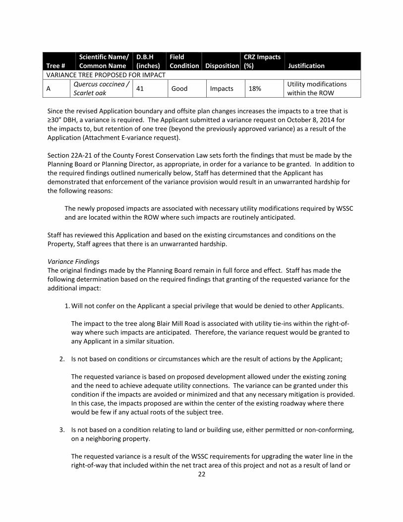
of the right-of-way are no longer proposed to be disturbed. The offsite LOD has the same square footage as previously approved but is in a different location than shown on the original approval. The new offsite utility work further impacts one tree that is subject to the forest conservation variance. Forest Conservation Variance Section 22A-12(b)(3) of Montgomery County Forest Conservation Law provides criteria that identify certain individual trees as high priority for retention and protection. Any impact to these trees, including removal of the subject tree or disturbance within the tree’s critical root zone (CRZ), requires a variance. An applicant for a variance must provide certain written information in support of the required findings in accordance with Section 22A-21 of the County Forest Conservation Law. Unless the variance is granted, the law requires no impact to trees that measure 30 inches DBH or greater; are part of a historic site or designated with a historic structure; are designated as national, state, or county champion trees; are at least 75 percent of the diameter of the current State champion tree of that species; or to trees, shrubs, or plants that are designated as Federal or State rare, threatened, or endangered species. The affected resources that have been identified on the current Plan include a tree with a DBH of 30 inches or greater. Tree “A” is the only additional impact requested under the revised variance request. The tree is located offsite immediately adjacent to the Blair Mill Road right-of-way. The tree was previously granted a variance for 2% impacts and the proposed impacts are now 18%.
Figure 11-Tree “A” impact exhibit
LOD for waterline
CRZ Impacts
22
Since the revised Application boundary and offsite plan changes increases the impacts to a tree that is ≥30” DBH, a variance is required. The Applicant submitted a variance request on October 8, 2014 for the impacts to, but retention of one tree (beyond the previously approved variance) as a result of the Application (Attachment E-variance request). Section 22A-21 of the County Forest Conservation Law sets forth the findings that must be made by the Planning Board or Planning Director, as appropriate, in order for a variance to be granted. In addition to the required findings outlined numerically below, Staff has determined that the Applicant has demonstrated that enforcement of the variance provision would result in an unwarranted hardship for the following reasons:
The newly proposed impacts are associated with necessary utility modifications required by WSSC and are located within the ROW where such impacts are routinely anticipated.
Staff has reviewed this Application and based on the existing circumstances and conditions on the Property, Staff agrees that there is an unwarranted hardship. Variance Findings The original findings made by the Planning Board remain in full force and effect. Staff has made the following determination based on the required findings that granting of the requested variance for the additional impact: 1. Will not confer on the Applicant a special privilege that would be denied to other Applicants.
The impact to the tree along Blair Mill Road is associated with utility tie-ins within the right-of-way where such impacts are anticipated. Therefore, the variance request would be granted to any Applicant in a similar situation.
2. Is not based on conditions or circumstances which are the result of actions by the Applicant;
The requested variance is based on proposed development allowed under the existing zoning and the need to achieve adequate utility connections. The variance can be granted under this condition if the impacts are avoided or minimized and that any necessary mitigation is provided. In this case, the impacts proposed are within the center of the existing roadway where there would be few if any actual roots of the subject tree.
3. Is not based on a condition relating to land or building use, either permitted or non-conforming,
on a neighboring property.
The requested variance is a result of the WSSC requirements for upgrading the water line in the right-of-way that included within the net tract area of this project and not as a result of land or
Tree # Scientific Name/ Common Name
D.B.H (inches)
Field Condition Disposition
CRZ Impacts (%) Justification
VARIANCE TREE PROPOSED FOR IMPACT
A Quercus coccinea / Scarlet oak
41 Good Impacts 18% Utility modifications within the ROW
23
building use on a neighboring property.
4. Will not violate State water quality standards or cause measurable degradation in water quality.
Granting this variance request will not violate State water quality standards or cause measurable degradation in water quality. The DPS review and ultimate approval of the sediment and erosion control and storm water management plans will ensure that appropriate standards are met. The subject area is not directly associated with any streams, wetlands or related buffers. Furthermore there would be few if any actual roots of the subject tree within the center of the existing roadway and the canopy of the tree will not be affected. Therefore, the temporary impacts to the right-of-way will not violate State water quality standards or cause measurable degradation in water quality.
Mitigation for Trees Subject to the Variance The Application proposes to satisfy all of the previously required variance mitigation plantings within the first phase (F1-F2 Site Plan). The Application includes 21 native canopy tree plantings that range in size from 3” to 5” caliper; for a total of 79” of caliper, which more than satisfies the variance requirements (based on total caliper inches of the replacements). However, condition #9 of the approved Project Plan requires the Applicant to plant twenty-four (24) 3” caliper trees, which totals 72” inches of caliper. Based on the condition, there are three (3) less mitigation trees planted at this time. Therefore, to fully satisfy the Project Plan condition, three more 3” caliper trees will be shown on the FFCP and planted at a later phase. Staff does not recommend mitigation plantings for variance that are not removed or overly impacted. The proposed impacts to the subject tree are minor, particularly since the impacts are proposed within the center of the roadway where the associated roots would generally be absent or very diminished. County Arborist Recommendation In accordance with Montgomery County Code Section 22A-21(c), the Planning Department is required to refer a copy of the variance request to the County Arborist in the Montgomery County Department of Environmental Protection for a recommendation prior to acting on the request. The Applicants’ revised request was forwarded to the County Arborist on October 8, 2014. The County Arborist issued a response to the variance request on October 10, 2014 and recommended the variance be approved with the condition that mitigation is provided (Attachment F). Additionally, the County Arborist provided general recommendations on calculating mitigation plantings and providing tree preservation measures. Staff Recommendation on Variance As a result of the above findings, Staff recommends the Board approve the Applicant’s new request for a variance from Forest Conservation Law to impact (but retain) one additional subject tree associated with the Application. The previously approved variance stands except as amended herein. The variance approval is assumed into the Planning Board’s approval of the Final Forest Conservation Plan. Noise A noise analysis dated October 10, 2014, was prepared by Polysonics Acoustical & Technology Consulting. The analysis shows that the 65 dba Ldn contour does not enter the Subject Property at this Site Plan. The analysis also showed that the current phase is marginally affected along Eastern Avenue

24
by the existing and projected 60 dBA Ldn noise contour. However, the 65 dba Ldn is the minimum standard threshold trigging noise mitigation requirements; therefore, no noise attenuation measures are necessary. Furthermore, the report concludes that interior noise levels will be less than 45 dBA Ldn with appropriate windows utilized to mitigate the sound. Stormwater Management DPS issued a letter accepting the Stormwater Management Concept for the Property on September 10, 2014 (Attachment G). The Stormwater Management Concept proposes to meet required stormwater management goals via the use of green roof and micro-biofiltration/planter boxes. Additional treatment will be provided via proprietary underground structural volume based filters.
ANALYSIS AND FINDINGS – Sec 59-D-3.4(c)
1. The site plan conforms to all non-illustrative elements of a development plan or diagrammatic plan, and all binding elements of a schematic development plan, certified by the Hearing Examiner under Section 59-D-1.64, or is consistent with an approved project plan for the optional method of development, if required, unless the Planning Board expressly modifies any element of
the project plan. The Application is subject to the approved Project Plan. The Application conforms to all of the conditions of the approved Project Plan as shown in the following table. The Application is consistent with the Project Plan findings.
Approved Project Plan Conditions: Proposed Site Plan conforms:
1. Development Ceiling The development is limited to a maximum 2.89 FAR, and a maximum 3,825,400 gross floor area consisting of a maximum 450,000 square feet of commercial uses and a maximum 2,800 residential units (new and existing).
This is the first phase of the Blairs Master Plan site and the Applicant will comply with the development ceiling. A total of 605,000 square feet of residential uses are proposed bringing the total remaining for development in future phases to 3,220,400 square feet.
2. Housing The Applicant must provide a minimum of 12.5% of the total number of newly constructed units as Moderately Priced Dwelling Units on-site, consistent with the requirements of Chapter 25A, in accordance with the Department of Housing and Community Affairs letter dated August 13, 2013.
The Applicant will provide a minimum of 12.5% of the total number of newly constructed units as Moderately Priced Dwelling Units on-site. See Site Plan Condition 12.
3. Architecture, Building Height, and Mass a) The buildings within the upper escarpment (Parcels A, E,
and F) and lower escarpment, Parcel H, are limited to a maximum building height of 200 feet as determined by the Department of Permitting Services applicable building height measurement point.
b) The buildings within the lower escarpment, Parcel G, are
The maximum height for Blocks F1 & F2 is 180 feet and will maintain the minimum setbacks set forth in the Project Plan. (See Application Data Table, page 29 and compatibility finding on page 31)
25
limited to a maximum building height of 180 feet as measured from their respective fronts as determined by the Department of Permitting Services applicable building height measurement point.
c) Buildings in Block G of Parcel G must maintain a minimum setback from the current northerly right-of-way line of Blair Mill Road of 16 feet (townhouse building face; 0 feet to courtyards). The maximum height for these buildings will be further reviewed at the site plan stage for compatibility. Maximum building height permitted will be based upon building step backs, materials, massing, and architecture.
d) Buildings in blocks F1 and F2 of Parcel G must maintain a minimum setback from the current northerly right-of-way line of Eastern Avenue of 18 feet for townhouse building face (as to F-1), and 16 feet for townhouse building face (as to F-2). The maximum height for these buildings will be further reviewed at the site plan stage for compatibility. Maximum building height permitted will be based upon building step backs, materials, massing, and architecture.
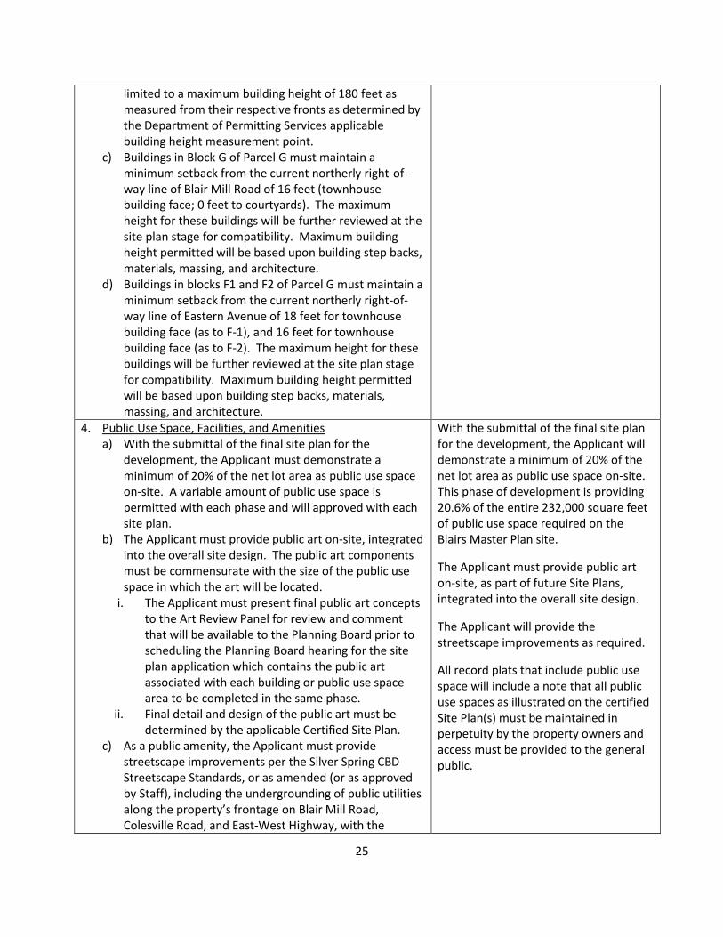
4. Public Use Space, Facilities, and Amenities a) With the submittal of the final site plan for the
development, the Applicant must demonstrate a minimum of 20% of the net lot area as public use space on-site. A variable amount of public use space is permitted with each phase and will approved with each site plan.
b) The Applicant must provide public art on-site, integrated into the overall site design. The public art components must be commensurate with the size of the public use space in which the art will be located.
i. The Applicant must present final public art concepts to the Art Review Panel for review and comment that will be available to the Planning Board prior to scheduling the Planning Board hearing for the site plan application which contains the public art associated with each building or public use space area to be completed in the same phase.
ii. Final detail and design of the public art must be determined by the applicable Certified Site Plan.
c) As a public amenity, the Applicant must provide streetscape improvements per the Silver Spring CBD Streetscape Standards, or as amended (or as approved by Staff), including the undergrounding of public utilities along the property’s frontage on Blair Mill Road, Colesville Road, and East-West Highway, with the
With the submittal of the final site plan for the development, the Applicant will demonstrate a minimum of 20% of the net lot area as public use space on-site. This phase of development is providing 20.6% of the entire 232,000 square feet of public use space required on the Blairs Master Plan site.
The Applicant must provide public art on-site, as part of future Site Plans, integrated into the overall site design.
The Applicant will provide the streetscape improvements as required.
All record plats that include public use space will include a note that all public use spaces as illustrated on the certified Site Plan(s) must be maintained in perpetuity by the property owners and access must be provided to the general public.
26
phasing of the streetscape improvements determined at the time of the applicable site plan which adjoins the particular frontages.
d) All record plats that include public use space must include a note that all public use spaces as illustrated on the certified Site Plan(s) must be maintained in perpetuity by the property owners and access must be provided to the general public.
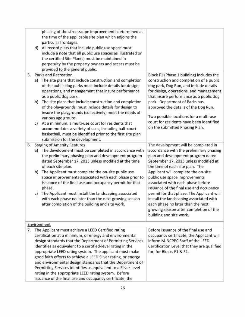
5. Parks and Recreation a) The site plans that include construction and completion
of the public dog parks must include details for design, operations, and management that insure performance as a public dog park.
b) The site plans that include construction and completion of the playgrounds must include details for design to insure the playgrounds (collectively) meet the needs of various age groups.
c) At a minimum, a multi-use court for residents that accommodates a variety of uses, including half-court basketball, must be identified prior to the first site plan submission for the development.
Block F1 (Phase 1 building) includes the construction and completion of a public dog park, Dog Run, and include details for design, operations, and management that insure performance as a public dog park. Department of Parks has approved the details of the Dog Run.
Two possible locations for a multi-use court for residents have been identified on the submitted Phasing Plan.
6. Staging of Amenity Features a) The development must be completed in accordance with
the preliminary phasing plan and development program dated September 17, 2013 unless modified at the time of each site plan.
b) The Applicant must complete the on-site public use space improvements associated with each phase prior to issuance of the final use and occupancy permit for that phase.
c) The Applicant must install the landscaping associated with each phase no later than the next growing season after completion of the building and site work.
The development will be completed in accordance with the preliminary phasing plan and development program dated September 17, 2013 unless modified at the time of each site plan. The Applicant will complete the on-site public use space improvements associated with each phase before issuance of the final use and occupancy permit for that phase. The Applicant will install the landscaping associated with each phase no later than the next growing season after completion of the building and site work.
Environment
7. The Applicant must achieve a LEED Certified rating certification at a minimum, or energy and environmental design standards that the Department of Permitting Services identifies as equivalent to a certified-level rating in the appropriate LEED rating system. The applicant must make good faith efforts to achieve a LEED Silver rating, or energy and environmental design standards that the Department of Permitting Services identifies as equivalent to a Silver-level rating in the appropriate LEED rating system. Before issuance of the final use and occupancy certificate, the
Before issuance of the final use and occupancy certificate, the Applicant will inform M-NCPPC Staff of the LEED Certification Level that they are qualified for, for Blocks F1 & F2.
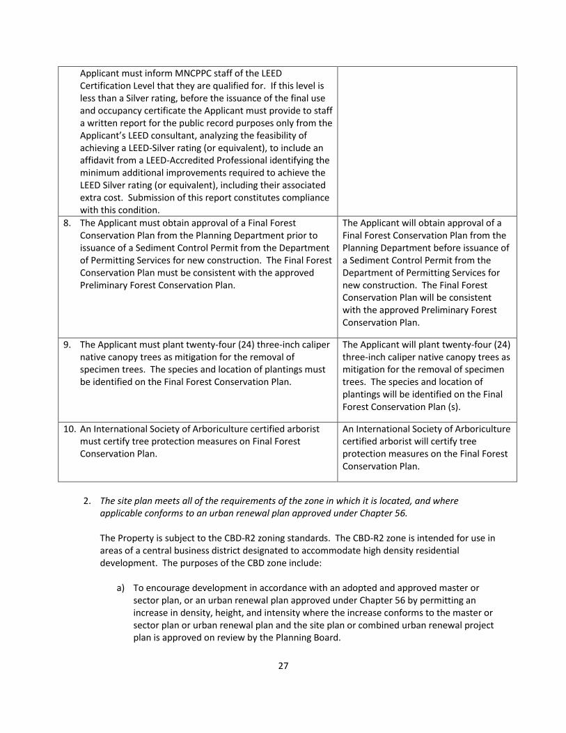
27
Applicant must inform MNCPPC staff of the LEED Certification Level that they are qualified for. If this level is less than a Silver rating, before the issuance of the final use and occupancy certificate the Applicant must provide to staff a written report for the public record purposes only from the Applicant’s LEED consultant, analyzing the feasibility of achieving a LEED-Silver rating (or equivalent), to include an affidavit from a LEED-Accredited Professional identifying the minimum additional improvements required to achieve the LEED Silver rating (or equivalent), including their associated extra cost. Submission of this report constitutes compliance with this condition.
8. The Applicant must obtain approval of a Final Forest Conservation Plan from the Planning Department prior to issuance of a Sediment Control Permit from the Department of Permitting Services for new construction. The Final Forest Conservation Plan must be consistent with the approved Preliminary Forest Conservation Plan.
The Applicant will obtain approval of a Final Forest Conservation Plan from the Planning Department before issuance of a Sediment Control Permit from the Department of Permitting Services for new construction. The Final Forest Conservation Plan will be consistent with the approved Preliminary Forest Conservation Plan.
9. The Applicant must plant twenty-four (24) three-inch caliper native canopy trees as mitigation for the removal of specimen trees. The species and location of plantings must be identified on the Final Forest Conservation Plan.
The Applicant will plant twenty-four (24) three-inch caliper native canopy trees as mitigation for the removal of specimen trees. The species and location of plantings will be identified on the Final Forest Conservation Plan (s).
10. An International Society of Arboriculture certified arborist must certify tree protection measures on Final Forest Conservation Plan.
An International Society of Arboriculture certified arborist will certify tree protection measures on the Final Forest Conservation Plan.
2. The site plan meets all of the requirements of the zone in which it is located, and where
applicable conforms to an urban renewal plan approved under Chapter 56. The Property is subject to the CBD-R2 zoning standards. The CBD-R2 zone is intended for use in areas of a central business district designated to accommodate high density residential development. The purposes of the CBD zone include:
a) To encourage development in accordance with an adopted and approved master or sector plan, or an urban renewal plan approved under Chapter 56 by permitting an increase in density, height, and intensity where the increase conforms to the master or sector plan or urban renewal plan and the site plan or combined urban renewal project plan is approved on review by the Planning Board.
28
b) To permit a flexible response of development to the market as well as to provide incentives for the development of a variety of land uses and activities in central business districts to meet the needs and requirements of workers, shoppers and residents.
c) To encourage designs which produce a desirable relationship between the individual buildings in the central business district, between the buildings and the circulation system and between the central business district and adjacent areas.
d) To promote the effective use of transit facilities in the central business district and pedestrian access thereto.
e) To promote improved pedestrian and vehicular circulation. f) To assist in the development of adequate residential areas for people with a range of
different incomes. g) To encourage land assembly and the most desirable use of land in accordance with a
sector plan. The CBD-R2 zone is intended for use in areas of a central business district designated to accommodate high density residential development. The purposes of the CBD-R2 zone is to foster and promote the orderly development of the Central Business Districts of the county so that these areas will enhance the economic status of the county as well as providing an expanding source of employment and living opportunities for its citizens in a desirable urban environment. The entire Blairs Master Plan development will provide a maximum of 3,825,400 square feet of gross floor area, comprised of 450,000 square feet for commercial uses (including retail, office, and hotel) and 3,375,400 square feet for residential uses. As approved, the residential component will provide a total of up to 2,800 residential dwelling units, of which 1,690 will be newly constructed units. The Application proposes to accomplish the residential and commercial densities recommended for the Property in the Sector Plan; to maintain proposed building heights within the limits of the zone, and in a compatible manner with adjoining uses; and to promote a walkable environment with multiple public use spaces and amenities accessible to users of the Property and to the surrounding community. The Application meets the purposes of the CBD-R2 Zone. Nearly all of the Blairs Master Plan site is located within ¼ mile of the Silver Spring Metro Station. The F1-F2 Application will provide a significant increase in multi-family residential units in close proximity to public transit, as well as providing an additional dwelling type: apartments with private stoops. The new residential units in the F1-F2 Building are intended to be rental units, and will vary in price depending on their sizes and amenities. For all new units constructed, the Applicant will be providing MPDUs. With the Application, up to 507 new residential units with 64 new MPDUs are required and will be provided. The proposed multi-family building and circulation system create a desirable relationship with adjacent buildings and surrounding neighborhoods through comparable or compatible building heights and existing access connections. The Application will promote improved pedestrian and vehicular circulation through its design of interconnected private streets, sidewalks, and public use spaces. The Applicant will provide the minimum five-foot wide sidewalks on the perimeter of the site, The Mews area, Dog Run, and other elements of the on-site public use space areas.
29
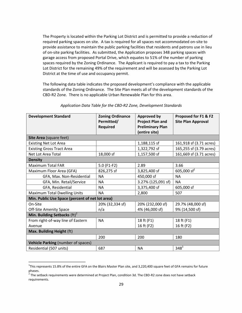
The Property is located within the Parking Lot District and is permitted to provide a reduction of required parking spaces on site. A tax is required for all spaces not accommodated on-site to provide assistance to maintain the public parking facilities that residents and patrons use in lieu of on-site parking facilities. As submitted, the Application proposes 348 parking spaces with garage access from proposed Portal Drive, which equates to 51% of the number of parking spaces required by the Zoning Ordinance. The Applicant is required to pay a tax to the Parking Lot District for the remaining 49% of the requirement and will be assessed by the Parking Lot District at the time of use and occupancy permit.
The following data table indicates the proposed development’s compliance with the applicable standards of the Zoning Ordinance. The Site Plan meets all of the development standards of the CBD-R2 Zone. There is no applicable Urban Renewable Plan for this area.
Application Data Table for the CBD-R2 Zone, Development Standards
Development Standard Zoning Ordinance Permitted/ Required
Approved by Project Plan and Preliminary Plan (entire site)
Proposed for F1 & F2 Site Plan Approval
Site Area (square feet)
Existing Net Lot Area 1,188,115 sf 161,918 sf (3.71 acres)
Existing Gross Tract Area 1,322,792 sf 165,255 sf (3.79 acres)
Net Lot Area Total 18,000 sf 1,157,500 sf 161,669 sf (3.71 acres)
Density
Maximum Total FAR 5.0 (F1-F2) 2.89 3.66
Maximum Floor Area (GFA) 826,275 sf 3,825,400 sf 605,000 sf1
GFA, Max. Non-Residential NA 450,000 sf NA
GFA, Min. Retail/Service NA 3.27% (125,091 sf) NA
GFA, Residential NA 3,375,400 sf 605,000 sf
Maximum Total Dwelling Units NA 2,800 507
Min. Public Use Space (percent of net lot area)
On-Site Off-Site Amenity Space
20% (32,334 sf) n/a
20% (232,000 sf) 4% (46,000 sf)
29.7% (48,000 sf) 9% (14,500 sf)
Min. Building Setbacks (ft)2
From right-of-way line of Eastern Avenue
NA 18 ft (F1) 16 ft (F2)
18 ft (F1) 16 ft (F2)
Max. Building Height (ft)
200 200 180
Vehicle Parking (number of spaces)
Residential (507 units) 687 NA 3483
1This represents 15.8% of the entire GFA on the Blairs Master Plan site, and 3,220,400 square feet of GFA remains for future
phases. 2 The setback requirements were determined at Project Plan, condition 3d. The CBD-R2 zone does not have setback
requirements.
30
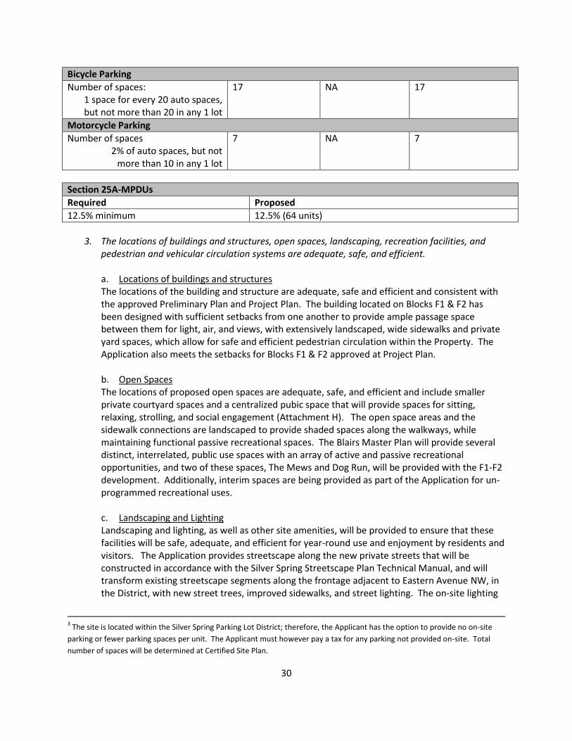
Bicycle Parking
Number of spaces: 1 space for every 20 auto spaces, but not more than 20 in any 1 lot
17 NA 17
Motorcycle Parking
Number of spaces 2% of auto spaces, but not
more than 10 in any 1 lot
7 NA 7
Section 25A-MPDUs
Required Proposed
12.5% minimum 12.5% (64 units)
3. The locations of buildings and structures, open spaces, landscaping, recreation facilities, and
pedestrian and vehicular circulation systems are adequate, safe, and efficient. a. Locations of buildings and structures The locations of the building and structure are adequate, safe and efficient and consistent with the approved Preliminary Plan and Project Plan. The building located on Blocks F1 & F2 has been designed with sufficient setbacks from one another to provide ample passage space between them for light, air, and views, with extensively landscaped, wide sidewalks and private yard spaces, which allow for safe and efficient pedestrian circulation within the Property. The Application also meets the setbacks for Blocks F1 & F2 approved at Project Plan. b. Open Spaces The locations of proposed open spaces are adequate, safe, and efficient and include smaller private courtyard spaces and a centralized pubic space that will provide spaces for sitting, relaxing, strolling, and social engagement (Attachment H). The open space areas and the sidewalk connections are landscaped to provide shaded spaces along the walkways, while maintaining functional passive recreational spaces. The Blairs Master Plan will provide several distinct, interrelated, public use spaces with an array of active and passive recreational opportunities, and two of these spaces, The Mews and Dog Run, will be provided with the F1-F2 development. Additionally, interim spaces are being provided as part of the Application for un-programmed recreational uses. c. Landscaping and Lighting Landscaping and lighting, as well as other site amenities, will be provided to ensure that these facilities will be safe, adequate, and efficient for year-round use and enjoyment by residents and visitors. The Application provides streetscape along the new private streets that will be constructed in accordance with the Silver Spring Streetscape Plan Technical Manual, and will transform existing streetscape segments along the frontage adjacent to Eastern Avenue NW, in the District, with new street trees, improved sidewalks, and street lighting. The on-site lighting
3 The site is located within the Silver Spring Parking Lot District; therefore, the Applicant has the option to provide no on-site
parking or fewer parking spaces per unit. The Applicant must however pay a tax for any parking not provided on-site. Total
number of spaces will be determined at Certified Site Plan.
31
will limit the necessary light levels to streets and sidewalks and will prevent light spillover to adjacent areas. Site furnishings will be integrated within the site to create a unique and interesting place and ensure accessibility and comfort. d. Recreation Facilities The on-site recreation amenities are dispersed throughout the site, and include 16 bench/picnic seating areas, pedestrian circulation system, a swimming pool, indoor community space and an indoor fitness facility (Attachment I). The proposed development meets the required supply of recreation facilities based on the Planning Board’s Recreation Guidelines. The portions of the Blair Towers development (proposed future Blocks G & E) that fall outside of the proposed F1-F2 Application will provide interim uses including unimproved outdoor space that can accommodate a variety of temporary and unplanned functions or amenities, such as farmers' markets, festivals, and other informal active recreation. They will remain until future phases of the Blairs Master Plan are redeveloped. The proposed development will provide adequate, safe, and efficient recreation facilities. e. Pedestrian and Vehicular Circulation Systems The Application’s vehicular circulation system has been designed to promote safe and efficient accessibility within the Subject Property for residents and visitors. The Blairs Master Plan will provide a network of private streets. Portions of Portal Drive and Street C will be constructed in connection with the Application, to provide access to the parking and loading areas for the F1-F2 Building. The loading and service areas for the building have been designed in an efficient way to provide adequate areas for these functions that are away from prime pedestrian areas and building entrances, but close to private and public street access points. The Application also proposes to provide its portion of the pedestrian circulation system, intended to provide numerous accessible pathways for residents, visitors and surrounding community members to destinations within the Blairs Master Plan development and to areas in close proximity, such as Silver Spring Metro. The private street system provides access for emergency vehicles and other public services, and allows the installation of public utilities.
4. Each structure and use is compatible with other uses and other site plans, and with existing and proposed adjacent development. The F1-F2 Application is compatible with the existing and potential development in the general neighborhood and within the Blairs Master Plan Property. The Project Plan stated the maximum height for these buildings to be further reviewed at the Site Plan stage for compatibility and the maximum building height permitted will be based upon building step backs, materials, massing, and architecture. The approved Project Plan limited the height for buildings within the lower escarpment to a maximum of 180 feet as measured from the respective fronts as determined by DPS. The taller portions of the F1-F2 Building have been designed to ensure compatibility with high and low rise neighbors. The existing Blair House, to the west of the Phase 1 Building, reaches a height of 12 stories (approximately 120 feet). This compares well with the wider seven-story and narrower 14 story elements of the Phase 1 Building. The lower and middle building volumes nearest Eastern Avenue have been designed for compatibility with the single-family houses across Eastern Avenue and Blair Mill Road. These portions of F1-F2 Building present a narrower seven-story face and a wider five-story façade that gives the appearance of four stories from the street to Eastern Avenue and the residences in the District. Additionally,
32
the Application proposes to set back the five story wings of Building F1-F2 at least 24 feet from the Eastern Avenue right-of-way, exceeding the minimum setbacks required by the Planning Board at Project Plan to ensure compatibility.4 The F2 building addition steps up as it moves away from Eastern Avenue and presents its wider seven-story element and narrower 18 story element to the adjacent Block G portion of the Blairs Master Plan site, but will be separated by the triangular green area of Fitness Green. The heights within the building are used to address conditions adjacent to each area and are comparable to existing building heights. Per Section 59-C-6.235(b), the Planning Board can approve a height that exceeds 143 feet, up to 200 feet, in the CBD-R2 zone for an optional method of development in the process of Site Plan. The Site Plan conforms to the density limitations of the Sector Plan and the height limits set forth in the approved Project Plan.
5. The site plan meets all applicable requirements of Chapter 22A regarding forest conservation, Chapter 19 regarding water resource protection, and any other applicable laws.
a. Forest Conservation The plan is in compliance with the M-NCPPC’s Environmental Guidelines and Forest Conservation Law. Staff recommends that the Planning Board approve the Final Forest Conservation Plan for Blocks F1 & F2 as part of the Application with the conditions cited in this Staff Report. b. Stormwater Management A Stormwater Concept Plan was accepted by the Montgomery County Department of Permitting Services (DPS) on Date September 10, 2014.
Compliance with Prior Approvals The Application complies with applicable conditions approved in the Project Plan Resolution No. 13-109 and Preliminary Plan Resolution No. 13-110.
COMMUNITY OUTREACH The Applicant conducted a pre-filing community meeting on May 13, 2014. The Applicant has also met with the Neighborhoods Committee of the Silver Spring Citizens' Advisory Board and the Urban District Advisory Committee, the Transportation Management District Advisory Committee, the Greater Silver Spring Chamber of Commerce, and the Arts and Entertainment District Advisory Committee. The Applicant has complied with all submittal and noticing requirements. Staff has received correspondence from the Silver Spring Citizens Advisory Board, the Silver Spring Transportation Management District Advisory Committee, and the Greater Silver Spring Chamber of Commerce in support of this Site Plan as of the date of this report. (Attachment K) 4 The Planning Board Resolution for the Project Plan requires a minimum setback from the current northerly right-of-way line of
Eastern Avenue of 18 feet for the face of the Phase 1 Building's five story wing (formerly envisioned as townhouses at the time
of Project Plan), and 16 feet for the face of the Phase 2 Addition's five story wing .
33
ATTACHMENTS: A. Project Plan Resolution B. Preliminary Plan Resolution C. Applicant’s Request for Permit Filing and Processing D. Final Forest Conservation Plan E. Revised variance request F. Response Letter from County Arborist G. Department of Permitting Services Stormwater Acceptance letter H. Open Space Exhibit I. On-site Recreation Facilities Plan J. Advisory Groups Letters of Support K. Agency Approval Letters L. F1-F2 Site Plan