simulating the streets of tomorrow an innovative...
TRANSCRIPT

Simulating The Streets of TomorrowAn Innovative Approach to Modelling Shared Space

CH2M1 The SquareBristolUnited KingdomBS1 6DG
Issue:2
Author:[email protected]
Date:April 2015
Printing:A3 double sidedFlip on short edge
Disclaimer:© CH2M 2015. All rights reserved. This document and the ideas incorporatedherein is the property of CH2M Inc. Any reuse, modification, or alteration of this document and the ideas incorporated herein is at the sole risk of the party(ies) reusing, modifying, or altering it.

Simulating The Streets of TomorrowAn Innovative Approach to Modelling Shared Space
1
1 INTRODUCTIONThis chapter introduces the concept of shared space, outlines the aims of the document andprovides a brief overview of CH2M.

INTRODUCTION
With the demand on our towns and cities growing at an ever increasing rate, multi-functional streets which offer enhanced pedestrian movement and a genuine sense of ‘place’ are likely to play a important part in achieving sustainable urban growth.
One possible solution to the problem of overcrowded, unclean, car dominated streets is ‘shared space’. The philosophy of which seeks to readdress the hierarchy of road usership by returning a higher level of significance to the pedestrian. This is generally achieved by forcing drivers to interact with their surroundings at a more ‘human’ level, thus creating an environment where pedestrians are considered to be ‘stakeholders’ of equal value rather than just basic ‘users’.
As a concept, true shared space is very difficult to model. A number of consultants (and some software developers too) claim to have modelled shared space. In reality though, most are simply simulating standard pedestrian crossing points where control has been ‘lifted’ for a small section of the road or basic speed calming measures.
While not intentionally trying to deceive, there is genuine uncertainty, both within the industry and among the general public, as to what exactly qualifies as shared space and whether it can ever truly ‘work’ as intended given the dominance of the car. While it is unlikely that this skepticism will go away anytime soon, it is hoped that through research like this, further debate on the merits of shared space will at least be inspired.
ABOUT THIS REPORT
Like many consultants, CH2M HILL has received multiple requests from clients asking if shared space can be modelled. Up until now, our answer to this has always been a rather disappointed “No, not really”.
Given the frequency of these requests, we have set out to investigate possible ways of simulating shared space, culminating in the production of this document which we hope will benefit others.
Looking holistically, the aims of the document are:
To present one method for simulating shared space in micro-simulation
To present the results of a series of tests looking at the maximum vehicular-pedestrian flow combinations for a basic shared space arrangement
To act as a starting point for further consultant-led research into the simulation of shared space
To inspire further debate among engineers, designers, modellers and planners not only on shared space but also the growing need for roads to fulfil different functions
To accelerate and encourage wider software development
To demonstrate scalable innovation within the field of micro-simulation modelling
•
•
•
•
•
•
ABOUT CH2M HILL
As a global leader in consulting, design and programme management, CH2M helps clients achieve success in every corner of the world.
Whether it is the visioning of tomorrow’s smarter cities or the regeneration of our forgotten centres, we look to provide integrated and innovative solutions to a wide range of engineering problems.
At CH2M, we feel strongly that movement led place-making supported by high quality public realm and a range of transport alternatives are critical factors in establishing places where people will want to live, work and play for years to come. As a company, the ideologies of shared space are in keeping with our own beliefs that engineering should be safe, clean and capable of delivering wide reaching socio-economic benefits.
In addition to major project involvement in Crossrail, High Speed 2 and the redesign of Tottenham Court Road, we have a wealth of experience delivering award-winning local public realm and traffic engineering schemes to the benefit everyday people across the UK and internationally.
For more details, please see our website.
Simulating The Streets of TomorrowAn Innovative Approach to Modelling Shared Space
1 - 1

Simulating The Streets of TomorrowAn Innovative Approach to Modelling Shared Space
2
2 A NEW APPROACH TO MODELLINGIn addition to answering the question of why is modelling important, this chapter sets out the key issues faced and explores one possible solution for the problem of how to simulate shared spacein micro-simulation.

WHAT CAN MODELLING OFFER?
It is widely accepted that the majority of schemes aimed at enhancing the public realm for pedestrians and cyclists will result in some disruptions to motorised users. This is due to the general lack of available space on our roads and footways.
With this in mind, integrated micro-simulation models can be an essential tool for quantifying the benefits for slower modes so that these can be used to offset any disbenefits for traffic.
The powerful visulisation capabilities of micro-simulation also allow us to communicate our ideas to non-technical audiences in a highly detailed and believable manner. More and more often, it is this visual output from the software that is getting our more debated schemes ‘over the line’.
Furthermore, micro-simulation can also be used as a platform to showcase the skills of our urban and landscape designers to add an extra dimension to their work.
PTV VISSIM-VISWALK
PTV Vissim and Viswalk are certainly not the only modelling tools capable of simulating the interaction between pedestrians and road users.
That said, the software does seem to provide the best fit with the emerging themes of the industry, such as:
The ability to model imaginative ‘out-of-the-box’ concepts in addition to more traditional arrangements
The ability to communicate with non-technical audiences through highly realistic 2 and 3D simulations
The ability to quickly simulate pedestrian volumes in the thousands both with and without ‘dynamic’ routing potential
The ability to use adaptive scripting to add increased flexibility and functionality to models
As with any package, however, the software does have its limitations, which in the context of modelling shared space, requires ‘workarounds’ to be developed.
Thankfully, due to features like the COM interface – which allows access to model objects and simulation data – such workarounds can at least be attempted.
•
•
•
•
Bris
tol T
empl
e C
ircus
Opt
ions
– M
odel
led
in P
TV V
issi
m-V
isw
alk
and
rend
ered
in A
utod
esk
3DS
Max
Simulating The Streets of TomorrowAn Innovative Approach to Modelling Shared Space
2 - 1

THE PROBLEM
Despite being billed as fully integrated, one of the major shortfalls of Vissim and Viswalk is the fact that pedestrians and road users do not share a common behavioural model. As such, area-based pedestrians cannot ‘see’ link-based vehicles.
While this lack of functionality is not overly important at standard signalised and zebra crossings, it is extremely relevant when trying to model something like shared space where pedestrians are expected to navigate around stationary and slow-moving vehicles.
Fundamentally speaking, if we are unable to replicate this behaviour robustly, the credibility of any model of shared space will be undermined.
While it is also the case that vehicles cannot see pedestrians, this is much less of an issue because, unlike pedestrians whose movement is more ‘fluid’, vehicles will always stay within the bounds of their notional lane. In the context of the software, this means that their interaction with pedestrians can be controlled using traditional methods such as priority rules and/or conflict areas.
However, when considering the other side of the coin, the use of priority rules and conflict areas to control the interaction between pedestrians and vehicles can be shown to fall over when pedestrians walk along diagonal and/or parallel paths. When this happens, instances of pedestrians ‘clipping’ or simply walking straight through a vehicle can be a regular occurrence.
Given the truly microscopic level of detail in which models of shared space will be scrutinised, incidents such as this are unlikely to be acceptable.
THE WORKAROUND
Accepting that traditional methods such as priority rules and conflict areas are not sophisticated enough to regulate the interaction between pedestrians and vehicles within shared space areas, a ‘non-standard’ method of control is required.
While one option could be to introduce hundreds (possibly thousands) of dynamic routing potentials for pedestrians, early experiments using this technique suggest it to lead to painfully slow simulations which in the long run, is unlikely to offer a viable solution.
This raises the questions of what can area-based pedestrians actually see and how best could these objects be used to ‘trick’ the software into seeing vehicles?
The answer to this is simple: by replacing vehicles with groups of other closely-packed area-based pedestrians.
By introducing ‘dummy’ pedestrians to a predefined grid made up of vehicle detectors and ‘micro’ areas, it is possible to repel ‘real’ pedestrians into walking around vehicles using the software’s social force model1.
The dummies can be added and removed to/from the grid using the COM activated commands ‘AddPedestrianOnAreaAtCoordinate’ and ‘RemovePedestrian’.
By triggering these events as and when a vehicle activates a downstream detector, the effect of moving obstacles can be produced.
Because the dummies are added and removed to/from the front and back of the group, obstacles which move with the vehicle in a ‘wave’ type motion can be created.The concept can be best seen in the following animation:
http://vimeo.com/118136127
While the method is not suitable for mimicking vehicles travelling at average (20-30 mph) or high (>30 mph) speeds, it would appear to be well suited to modelling shared space areas where free-flow speeds in the region of 15 mph are likely to be induced by the overall design.
The use of dummy pedestrians as obstacles can also be hidden from view by using a pseudo 3D model which, instead of looking like a human, is simply is a 0.5 m x 0.5 m square of zero height and its z axis aligned to -1 m.
This further trickery makes the dummies appear invisible, leaving only the real pedestrians and the vehicles behind.
Simulating The Streets of TomorrowAn Innovative Approach to Modelling Shared Space
2 - 2
1) Helbing, D. and Molnar, P, Social force model for pedestrian dynamics, Physical Review E 51, 4282-4286 (1995)

THE GRID
While the scripting used to add and remove dummy pedestrians to/from the model is relatively straightforward, it is the grid in which they are housed which is most intricate and requires the greatest attention to detail.
In order to serve its purpose, the grid must be constructed in a manner which allows for:
Real pedestrians to move freely in any desired direction
Interactions between vehicles and real pedestrians to be defined at a much finer level of granularity than normal
Dummy pedestrians to be added to the model at precise locations
Dummy pedestrians to remain in the same place while a vehicle is detected
Based on these requirements, a grid made up of the following network objects has been developed:
•
•
•
•
Vehicle Links
As per any standard Vissim model, vehicles and other road users travel across the shared space area on one or more one-directional links.
Detectors
Along these links exist back-to-back detectors. Each detector is 0.5 m long in keeping with the width of the dummy pedestrian 3D model.
Pedestrian Areas
Above each detector sits a ‘ladder’ of 0.5 m wide ‘micro’ areas which span the width of the link. By using multiple areas, dummy pedestrians can be added to adjacent cells to form blocks which broadly reflect the width of the road user detected.
Given that all area based pedestrians need to follow a static route2, the grid requires a second identical ‘tier’ of pedestrian areas so that routings can be defined.
The areas on tiers 1 and 2 of the grid are numbered in a consistent manner, based on the ‘port number’ of the detector which they sit above, their ‘lateral’ positon within the ladder and finally, the grid tier which they exist on.
By way of an example, detector 1001 would sit beneath pedestrian areas 100111, 100121, 100131, 100141 and 100151 on tier 1 of the grid and 100112, 100122, 100132, 100142 and 100152 on tier 2.
By numbering the areas in line with the detector they sit above, dummy pedestrians can be added and removed to/from the grid in the most fast and efficient manner.
Pedestrian Routes
As already mentioned, the pedestrian areas on tiers 1 and 2 of the grid are connected by individual pedestrian routing decisions linking them to the other tier.
Using the previous example, if a vehicle was detected by detector 1001, a dummy pedestrian would be introduced to pedestrian area 100111 (tier 1) before being routed to pedestrian area 100112 (tier 2).
Assuming that the detector was still occupied at the start of the next time-step, the dummy would then be routed back to 100111.
Because tiers 1 and 2 of the grid exist in the same location, the continuous ‘loop’ formed between 100111 and 100112 ensures that the dummy stays in the same place.
This back and forth between 100111 and 100112 continues until the detector is no longer occupied, at which point the dummy is then removed from the grid using the ‘RemovePedestrian’ command.
To speed up the removal process, the static route ‘number’ of each of the routing decisions (regardless of lateral position or tier) is set to the ‘port number’ of the detector beneath them. This eliminates the need to ‘search’ through all the dummies currently in the model using time consuming loops.
Simulating The Streets of TomorrowAn Innovative Approach to Modelling Shared Space
2 - 3
2) Beeline pedestrians were previously available in Vissim-Viswalk 5.40 but were removed in version 6

Pedestrian Links
In order to allow real pedestrians to cross the shared space area, a layer of overlapping pedestrian links, 0.55 m wide also exist. Because the links overlap subtly, an area is formed which allows pedestrians to seamlessly transfer from one link to the next and hence walk along diagonal paths. In addition to enabling a full range of pedestrian movements, the use of narrow pedestrian links also allows for priority rules to be constructed in a much more detailed manner.
Priority Rules - Pedestrians
While the key interactions between real pedestrians and vehicles within the shared space area are controlled using dummy pedestrians, multiple 1-second minimum gap priority rules have also been used at the outer edges of the area. This is to build in a degree of pedestrian hesitation into the model and ensure that they do not simply walk out into the path of an oncoming vehicle.
Priority Rules - Vehicles
Unlike pedestrians, who require a non-standard method of control, the interaction between vehicles and pedestrians can be controlled in full using traditional methods such as priority rules. With this in mind, the grid also assumes the following rules:
Pedestrian crossing from nearside: 3 m headway rules on 10 ‘ahead’ links (≈5 m) and 2 ‘prior’ links (≈1 m)
Pedestrian crossing from farside: 5 m headway rules3 on 10 ‘ahead’ links and 2 ‘prior’ links (≈5 m) and 2 ‘prior’ links (≈1 m)
A illustration of these can be seen opposite:
•
•
Simulating The Streets of TomorrowAn Innovative Approach to Modelling Shared Space
2 - 4
3) Headway can be more or less depending on the width of the shared space area and if a median strip is provided as part of the design
Vehi
cle
Prio
rity
Rul
es –
‘nea
rsid
e’ a
nd ‘f
arsi
de’ Y
ield
Zon
es

Automated Creation
Given that a typical grid will be made up of several thousand network objects and that each of these needs to be placed exactly, automated creation using the COM is the only realistic method for constructing the grid.
While it is not currently possible to write network objects straight to Vissim-Viswalk, the lines of coding which make up the grid elements can be printed to an empty inpx file which can then be reopened in the software.
The creation of the grid starts with the vehicle links about which all other objects are created. Having determined the number of vertices within the links, it is then necessary to calculate the X and Y of each of these points along with the angle between them.
With this information, intermediate points can then be determined using simple trigonometric functions and the bounding coordinates of the various objects calculated and written to the inpx file.
WALKING BEHAVIOURS
In addition to an exact grid of network objects, the use of dummy pedestrians as obstacles can only be realised when coupled with a series of modified walking behaviours.
The modifications are concentrated on three key parameters, namely ‘Reaction to N’, ‘VD’ and ‘Lambda’. In somewhat simplified terms, further details on these can be found below:
Dummies
A ‘Reaction to N’ equal to zero to make dummies ‘jitter’ as little as possible when bunched together
Real Pedestrians
An increased ‘Reaction to N’ to make real pedestrians avoid groups more (default value 8, recommended range 12-24)
A significantly increased ‘VD’ to make real pedestrians evade more (default value 3, recommended value 30)
A significantly increased ‘Lambda’ to make real pedestrians push through the gaps created between stationary vehicles (default 0.176, recommended value 1)
While ‘Reaction to N’ and ‘VD’ can both be increased further4 to make real pedestrians evade more, an element of caution should be exercised given the amount to which these parameters have already been modified from their intended defaults. As an alternative, a more controlled means of increasing the ‘strength’ of the effect appears to be by introducing more than one dummy pedestrian to each grid cell.
•
•
•
•
SOFTWARE PARAMETERS
While not viewed as essential, the workaround also benefits from the following global software parameter changes:
An increased ‘Grid Size’ to make real pedestrians anticipate the dummies from further away (default value 5 m, recommended range 8-15 m depending on the width of the shared space area and surrounding network)
An increased ‘Simulation Resolution’ of 10 time-steps per second to capture vehicle positions more often. Given this parameter has a dramatic impact on model run times, increasing it is only recommended for small models or for external rendering purposes. For the most part, the default simulation resolution of 5 time-steps per second is sufficient given the reduced vehicle speeds associated with shared space
•
•
Simulating The Streets of TomorrowAn Innovative Approach to Modelling Shared Space
2 - 5
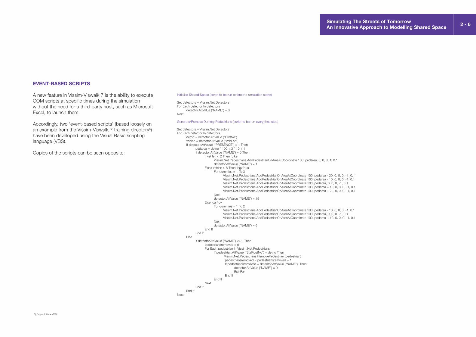
EVENT-BASED SCRIPTS
A new feature in Vissim-Viswalk 7 is the ability to execute COM scripts at specific times during the simulation without the need for a third-party host, such as Microsoft Excel, to launch them.
Accordingly, two ‘event-based scripts’ (based loosely on an example from the Vissim-Viswalk 7 training directory5) have been developed using the Visual Basic scripting language (VBS).
Copies of the scripts can be seen opposite:
Initialise Shared Space (script to be run before the simulation starts)
Set detectors = Vissim.Net.DetectorsFor Each detector In detectors detector.AttValue (“NAME”) = 0 Next
Generate/Remove Dummy Pedestrians (script to be run every time step)
Set detectors = Vissim.Net.DetectorsFor Each detector In detectors detno = detector.AttValue (“PortNo”) vehlen = detector.AttValue (“VehLen”) If detector.AttValue (“PRESENCE”) = 1 Then pedarea = detno * 100 + 3 * 10 + 1 If detector.AttValue (“NAME”) = 0 Then If vehlen < 2 Then ‘bike Vissim.Net.Pedestrians.AddPedestrianOnAreaAtCoordinate 100, pedarea, 0, 0, 0, 1, 0.1 detector.AttValue (“NAME”) = 1 ElseIf vehlen > 8 Then ‘hgv/bus For dummies = 1 To 3 Vissim.Net.Pedestrians.AddPedestrianOnAreaAtCoordinate 100, pedarea - 20, 0, 0, 0, -1, 0.1 Vissim.Net.Pedestrians.AddPedestrianOnAreaAtCoordinate 100, pedarea - 10, 0, 0, 0, -1, 0.1 Vissim.Net.Pedestrians.AddPedestrianOnAreaAtCoordinate 100, pedarea, 0, 0, 0, -1, 0.1 Vissim.Net.Pedestrians.AddPedestrianOnAreaAtCoordinate 100, pedarea + 10, 0, 0, 0, -1, 0.1 Vissim.Net.Pedestrians.AddPedestrianOnAreaAtCoordinate 100, pedarea + 20, 0, 0, 0, -1, 0.1 Next detector.AttValue (“NAME”) = 15 Else ‘car/lgv For dummies = 1 To 2 Vissim.Net.Pedestrians.AddPedestrianOnAreaAtCoordinate 100, pedarea - 10, 0, 0, 0, -1, 0.1 Vissim.Net.Pedestrians.AddPedestrianOnAreaAtCoordinate 100, pedarea, 0, 0, 0, -1, 0.1 Vissim.Net.Pedestrians.AddPedestrianOnAreaAtCoordinate 100, pedarea + 10, 0, 0, 0, -1, 0.1 Next detector.AttValue (“NAME”) = 6 End If End If Else If detector.AttValue (“NAME”) <> 0 Then pedestriansremoved = 0 For Each pedestrian In Vissim.Net.Pedestrians If pedestrian.AttValue (“StaRoutNo”) = detno Then Vissim.Net.Pedestrians.RemovePedestrian (pedestrian) pedestriansremoved = pedestriansremoved + 1 If pedestriansremoved = detector.AttValue (“NAME”) Then detector.AttValue (“NAME”) = 0 Exit For End If End If Next End if End If Next
Simulating The Streets of TomorrowAn Innovative Approach to Modelling Shared Space
2 - 6
5) Drop-off Zone.VBS
REALISM TESTS
When using any piece of software, either in a standard or – as in this case – a non-standard way, it is important to ensure that it responds rationally to the changes made as part of the calibration process.
While there are few or no empirical datasets for shared space schemes which could be replicated as part of formal realism tests, the workaround has been put through its paces using a series of simple models, based broadly on traditional UK ‘high street’ and contemporary ‘boulevard’ arrangements.
The primary aims of these tests were to identify any undesired behaviour such as:
Unrealistic pedestrian routing including:
Instances of long detours
Instances of pedestrians walking through vehicles
Unrealistic delays including:
Instances of extreme pedestrian hesitation before crossing
Instances of model gridlock due to pedestrian/vehicle ‘standoffs’
Excessive simulation run times
•
•
•
•
•
•
•
SAMPLE ANIMATIONS
Extracts from a selection of these tests can be seen in the animations linked to below:
http://vimeo.com/112572162
8 x 70 m shared space area1200 pcus/hour two-way1200 pedestrians/hour two-way
http://vimeo.com/112572163
8 x 120 m shared space area1000 pcus/hour two-way1500 pedestrians/hour two-way
http://vimeo.com/112572164
Three 70 m shared space ‘zones’ with median strips1500 pcus/hour two-way1500 pedestrians/hour two-way
http://vimeo.com/112572165
70 m shared space area with median strip750 pcus/hour two-way1000 pedestrians/hour two-way
http://vimeo.com/112572166
200 m non-linear shared space area100 one-way pcus/hour10000 two-way pedestrians/hour
OBSERVATIONS
Having tested the workaround using a variety of flow combinations and vehicle compositions, the use of dummy pedestrians and modified walking behaviours would appear to offer a robust method for mimicking stationary and slow-moving vehicles in shared space areas.
Not only does it appear to solve the key overarching problem of pedestrians walking through vehicles because they cannot see them, but it also appears to produce stable results with no signs of long detours or instances of model gridlock.
While some would argue that the workaround is too optimistic and that the majority of people would not step out in front of an approaching vehicle, we have to assume (from a modelling perspective) that the ideologies of shared space will translate into reality. In this respect, it is felt that a realistic amount of pedestrian hesitation can also be seen in the simulations.
As with any model, particularly those which adopt a non-standard approach, the workaround can be shown to produce some very occasional undesired behaviour.
For the most part, this is due to its inability to replicate true human behaviour (such as the ability to anticipate a vehicle’s direction of travel and change path accordingly) and the emotional response to factors (such as safety and cleanliness) which can cause humans to evade larger vehicles like HGVs and buses more.
As expected, one further downside of the workaround would appear to be increased simulation run times as a result of the scripted approach. Based on the test models produced, a simulation speed in the region of 1:3 real time was generally observed6.
Simulating The Streets of TomorrowAn Innovative Approach to Modelling Shared Space
2 - 7
6) Speeds based on Vissim 7.00-4 running on a Dell Precision T3600 Intel Xeon E5-1620 workstation with 16GB of RAM in ‘quick mode’

Simulating The Streets of TomorrowAn Innovative Approach to Modelling Shared Space
3
3 SUPPORTING THE DESIGN PROCESSWhile the ability to visualise a scheme is important, what decision makers really want to know is will shared space work for them? To help answer this question, a series of incremental tests have been run to show how the workaround could be used to give an idea of throughput. The results of this test can be found in this chapter.

CAPACITY ASSESSMENT
In addition to providing stakeholders and consultees with a tool for visualising potential schmes, the workaround also appears capable of providing designers with a legitimate means of estimating the throughput capacity of simple shared space areas.
To the best of our knowledge, this is a first for the traffic engineering and modelling communities.
By way of an example, a series of incremental tests have been run to determine the theoretical ‘breaking points’ of two such arrangements.
The designs, which comprise of a 60 m x 8 m rectangular shared space area, with and without central median strip, are comparable with those regularly considered for many traditional UK ‘high streets’.
The models, which can be seen opposite, include six evenly spaced pedestrian inputs on either side of the shared space area. Each input is set to generate 1/12th of the overall 2-way pedestrian ‘cross’ flow.
In order to capture a full range of pedestrian movements, including those on diagonal paths, routing proportions of equal weighting have been assumed between each of the ‘zones’.
Each flow combination has been run three times using different ‘random’ seeds with the total 2-way pedestrian flow incremented in steps of 100 until the model is unable to generate 100% of the vehicle input. When this happens, the flow combination is said to have ‘failed’ and throughput reached.
A vehicle composition of 100% cars has been assumed to allow easy conversion into passenger car units (pcus) per hour.
Results for the tests can be seen on the following page.
Simulating The Streets of TomorrowAn Innovative Approach to Modelling Shared Space
3 - 1
The
mod
els,
with
and
with
out
pede
stria
n ro
utes

Simulating The Streets of TomorrowAn Innovative Approach to Modelling Shared Space
3 - 2
CONCLUSIONS
Based on the results presented, it would appear that the workaround is capable of offering a robust solution to the problem of how to model shared space. With no instances of model gridlock recorded at any point during the tests, the workaround can be shown to produce consistent model run times in keeping with a stable offering.
While a vehicle composition of 100% cars is somewhat unrealistic, and the decision to increment demand in intervals of 100 a little coarse, there is no reason to doubt that the workaround couldn’t be used to derive further logical relationships for alternative sized shared space areas and site specific vehicle compositions.
Interestingly, the results presented appear to confirm the thoughts of many in that, for most of our ‘busy’ pedestrian streets, there would need to be a sizable reduction, or transfer of traffic on to alternative routes for shared space to ‘work’.
As we start to envisage how the ‘smarter’ streets of tomorrow will perform, it is highly likely that shared space will continue to be looked at as a potential solution to the problems of overcrowding, air quality and road safety. Up until now, the decision to implement shared space (or not) has always been somewhat of a ‘leap of faith’. With this in mind, the findings of this study clearly have the potential to help guide this process for the better. Given the significant construction and maintenance costs associated with public realm enhancements such as shared space, this has to be seen as a positive breakthrough.
Simulating The Streets of TomorrowAn Innovative Approach to Modelling Shared Space
3 - 3

Simulating The Streets of TomorrowAn Innovative Approach to Modelling Shared Space
4
4 SUMMARYThis chapter draws together the various elements of the document, summarising the findings and offering recommendations on possible adaptations and future uses.

OVERVIEW
Shared space is a term used to describe an emerging approach to urban design and traffic engineering which seeks to readdress the hierarchy of road usership by returning a higher level of importance to the pedestrian.
Elements of shared space are becoming more and more visible in our towns and cities as decision makers look to invest in the public realm. While some would argue that true shared space can never really be modelled, consultants have seen the number of requests for modelling assistance increase significantly in recent years as those same decision makers look for assurances that the impacts on road users will be minimal.
Despite this upsurge in interest, the modelling community has been somewhat slow to react to what is one of the key emerging trends of the industry. As such, little or no best-practice guidance or previous case studies currently exist.
At CH2M, we view ‘gaps’ in the market such as this as fantastic opportunities to not only find solutions to real problems but also demonstrate overarching innovation within our field.
With this in mind, we have set out to investigate the possible ways of simulating shared space in micro-simulation, culminating in the production of this document.
OUR SOLUTION
To the untrained eye, the concept of pedestrians and road users occupying the same space seems relatively simple. Trying to replicate and control this behaviour in a model, however, is extremely difficult. While a number of software packages are capable of simulating interactions at standard pedestrian crossings, none were designed with shared space in mind.
After only a few hours of observing shared space schemes in operation, we were quick to conclude that a non-standard approach to modelling would be required. Of the tools available to us, PTV Vissim and Viswalk were deemed to stand the greatest chance of allowing such a ‘workaround’ to be found due to features like the COM interface and the softwares extremely flexible priority rules.
Despite its many strengths, the software does have one significant weakness in that area-based pedestrians cannot see link-based vehicles and vice versa. While this lack of functionality is not overly important at standard pedestrian crossings, it is extremely relevant when trying to model something like shared space where pedestrians are expected to navigate around vehicles they encounter en route.
This raises the questions of what can area-based pedestrians actually see in Vissim-Viswalk and how best could these objects be used to ‘trick’ the software into seeing vehicles? The answer to this was simple: by replacing vehicles with groups of other closely-packed area-based pedestrians.
By introducing ‘dummy’ pedestrians to a predefined grid made up of vehicle detectors, it is possible to repel ‘real’ pedestrians into walking around vehicles using the software’s existing social force model and a series of modified walking behaviours.
Simulating The Streets of TomorrowAn Innovative Approach to Modelling Shared Space
4 - 1
CONCLUSIONS
Having tested the workaround using a variety of flow combinations and vehicle compositions, it would appear to offer a robust method for mimicking stationary and slow-moving vehicles in shared space areas.
In addition to providing stakeholders and consultees with a mechanism for visualising potential schemes, the method would also appear to be capable of providing designers with a legitimate means of estimating the throughput capacity of basic shared space areas. To the best of our knowledge, this is a first on both fronts.
As with any non-standard modelling approach, the workaround can at times be seen to produce some very occasional undesired behaviour. For the most part, this is due to its inability to replicate actual human behavioural and emotional responses to factors such as safety; something which is acknowledged as being a contentious issue when discussing the pros and cons of shared space.
As expected, the scripted solution also leads to increased simulation run times. However, it is worth remembering that despite enhanced computing powers, model run times across the industry are generally increasing as the extents of our models grow larger and the overall complexity of the arrangements being simulated increases.
Taking all factors into account, we believe the workaround offers an immediate and stable solution to the problem of how to model shared space in micro-simulation which could be adopted by others. Looking forward, we hope that the work will go on to inspire further research into the modelling of shared space as well as help influence and accelerate wider software development in the mid to long-term.

Simulating The Streets of TomorrowAn Innovative Approach to Modelling Shared Space
4 - 3
FURTHER DEVELOPMENT
While the outcomes of this research are largely seen as a success, further development of the workaround will be undertaken in an attempt to increase realism and improve simulation speeds. This includes:
An aspiration to work with PTV to investigate the benefits of additional COM functionality including:
A pedestrian equivalent to the Vissim.Net.Links.Vehs enumeration capable of collecting all pedestrians on a particular area or static route
The return of Beeline pedestrians
Investigating the use of larger 3D models, i.e. vehicle-shaped objects, in an attempt to reduce the number of dummies required
Revisiting the theory that adding multiple dummies to a grid cell is more effective than using increased walking behaviour parameter values
Undertaking further model runs of linear shared space arrangements to confirm that the workaround is stable and produces logical trends
Undertaking further investigations into non-linear arrangements i.e. entire shared space junctions and roundabouts
For further details, or the opportunity to discuss potential applications, please do not hesitate to get in contact.
•
•
•
•
•
•
•

CH2M1 The SquareBristolUnited KingdomBS1 6DG
Website:www.CH2M.com