significance of microclimatic study in urban canyons...
TRANSCRIPT

95
DOI: 10.15415/jotitt.2015.31007
Journal on Today’s Ideas – Tomorrow’s Technologies,
Vol. 3, No. 1, June 2015
pp. 95–109
Significance of Microclimatic Study in Urban Canyons Towards Ambient Urban Space Design
D.KaNNamma* aND Dr. a. meeNaTchI SuNDaram
Department of architecture, National Institute of Technology, Tiruchirappalli, India
*Email: [email protected]
received: april 17, 2015| revised: may 11, 2015| accepted: may 30, 2015
Published Online: June 29, 2015
The author(s) 2015. This article is published with open access at www.chitkara.edu.in/publications
Abstract: about 50% of the world’s population lives in cities, and the fraction is growing. Thus the study of the urban boundary layer and urban climate is of great importance.Since urban centres of the world have immense growth of population, their quality requires a very careful screening for sustainable future, growth and development. The quality of outdoor urban spaces is more significant in tropical countries like India, since the activities are shared between indoor and outdoor. There are clear links between the climate of a settlement and its potential sustainability. Its opportunities for gathering energy, its need for energy conservation and its ability to dispose of airborne wastes are largely controlled by the climate it experiences. moreover, urban design decisions will create microclimates that either accentuate or moderate the properties of the background climate. Thus, there is a clear role for an applied urban climatology in the planning of sustainable settlements. hence there is a compulsive need for providing ambient environmental conditions outdoors, specific to the pedestrian users. The uhI (urban heat Island) phenomenon though is influenced by many factors, the role of urban design and professionals like architects, urban designers and planners cannot be ignored. Often they are neglected when urban design principles get executed onsite. Therefore there is a need for understanding the urban microclimate interaction with the urban geometry elements for deriving design solutions and guidelines for the future. Though urban microclimate is also dependent on multiple factors this paper focuses on its relation with various urban geometry elements specific to the urban streets. The unit chosen for the study is ‘urban canyon’. To understand the microclimatic variation various profiles of urban canyons were selected. The urban microclimatic discomfort is given by the term “microclimatic Stress” and the thermal index used for the measurement is PeT (Physiological equivalent temperature) and rayman Pro is used for its calculation. The study of the canyons

Kannamma, DSundaram, am
96
concluded with findings that proved significant impact of street geometry elements on the microclimatic stress of urban outdoors.
Keywords: uhI; urban microclimate; Street Geometry; urban canyon; PeT; rayman Pro
1. InTroDUCTIon
If Design is understood to mean the shaping and fashioning of the physical world for a conscious human purpose, then there are very few environments in which we live and work which have not been influenced by Design and all human artefacts are by definition designed. although this is not a common meaning given to Design, it is useful to begin with such a definition because it helps make clear that Design is not an esoteric activity ... but an activity with which all humans are actively involved and which fundamentally influences every person’s life [29].heath ,points out that the interaction and perception of space is partly cultural, partly social and partly physiological [9]: ‘man’s relationship to his environment is a function of his sensory apparatus plus how this apparatus is conditioned to respond.’ The sensory apparatus includes visual, auditory and olfactory messages received via eyes, ears and nose, and thermal and tactile sensations through the receptor systems in skin and nerves. The climatic conditions in a man-made urban environment may differ appreciably from those in the surrounding natural or rural environs.... each urban man-made buildings, roads, parking area, factories etc creates around and above it a modified climate with which it interact [8]. The first scientific study of the urban climate as such was conducted by Luke
howard, who identified an urban heat island (uhI) in London [11].uhI is the increase in heat balance change; air temperature in densely built urban areas compared the temperatures of the surrounding country. uhI (urban heat Island) is a reflection of the totality of microclimatic changes brought about by man-made alterations of the urban surface [15].The impact of urban microclimate is influenced by both climatic and physical factors. This research paper focuses on the influence of street geometry element on the urban environment and this would help in deriving guidelines for climatically ambient urban space design for the professionals.
2. UrbAn HEAT ISlAnD (UHI)
urban heat island is one of the most important manifestations of the urban climate and has been the subject of much research since it was first described for the city of London by Luke howard in 1818. Its intensity

Significance of microclimatic
Study in urban canyons Towards
ambient urban Space Design
97
varies significantly on a diurnal and seasonal basis, and the phenomenon is known to be a complex one [7]. uhI effects are exacerbated by the anthropogenic heat generated by traffic, industry and domestic buildings, impacting the local climate through the city’s compact mass of buildings that affect exchange of energy and levels of conductivity. The higher temperatures in urban heat islands increase air conditioning demands, raise pollution levels, and may modify precipitation patterns. as a result, the magnitude and pattern of uhI effects have been major concerns of many urban climatology studies [30].
2.1 Definition
under certain weather conditions a substantial difference in temperature may be observed between a city and its surrounding rural areas. When isotherms are drawn for the area in question, the city is apparent as a series of concentric, closed lines of higher temperature, with maximum values recorded at or near
Figure 1: 1 Isotherms showing the mean minimum temperature for November 1981 in mexico city, demonstrating the existence of a nocturnal urban heat island (uhI) in the city (Source: Jauregui, 1986).
Kannamma, DSundaram, am
98
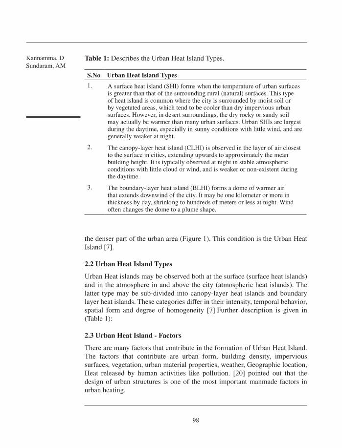
S.no Urban Heat Island Types
1. a surface heat island (ShI) forms when the temperature of urban surfaces is greater than that of the surrounding rural (natural) surfaces. This type of heat island is common where the city is surrounded by moist soil or by vegetated areas, which tend to be cooler than dry impervious urban surfaces. however, in desert surroundings, the dry rocky or sandy soil may actually be warmer than many urban surfaces. urban ShIs are largest during the daytime, especially in sunny conditions with little wind, and are generally weaker at night.
2. The canopy-layer heat island (cLhI) is observed in the layer of air closest to the surface in cities, extending upwards to approximately the mean building height. It is typically observed at night in stable atmospheric conditions with little cloud or wind, and is weaker or non-existent during the daytime.
3. The boundary-layer heat island (BLhI) forms a dome of warmer air that extends downwind of the city. It may be one kilometer or more in thickness by day, shrinking to hundreds of meters or less at night. Wind often changes the dome to a plume shape.
Table 1: Describes the urban heat Island Types.
the denser part of the urban area (Figure 1). This condition is the urban heat Island [7].
2.2 Urban Heat Island Types
urban heat islands may be observed both at the surface (surface heat islands) and in the atmosphere in and above the city (atmospheric heat islands). The latter type may be sub-divided into canopy-layer heat islands and boundary layer heat islands. These categories differ in their intensity, temporal behavior, spatial form and degree of homogeneity [7].Further description is given in (Table 1):
2.3 Urban Heat Island - Factors
There are many factors that contribute in the formation of urban heat Island. The factors that contribute are urban form, building density, impervious surfaces, vegetation, urban material properties, weather, Geographic location, heat released by human activities like pollution. [20] pointed out that the design of urban structures is one of the most important manmade factors in urban heating.

Significance of microclimatic
Study in urban canyons Towards
ambient urban Space Design
99
Table 2: Elaborates the application of microclimatology in urban planning.
S.No applications
1 Land use to be planned with coherence to multiple activities in a city.
2 Developing suitable microclimates based on open spaces and built spaces typologies
3 Planning master plans considering wind movement, solar radiation and humidity. (eg. wind can be used to solve issues of high humidity.
4 correct choice of building materials.
5 Transportation networks can be properly planned to minimize pollution.
3. UrbAn MICroClIMATE
a microclimate is the distinctive climate of a small-scale area, such as a garden, park, valley or part of a city. The weather variables in a microclimate, such as temperature, rainfall, wind or humidity, may be subtly different to the conditions prevailing over the area as a whole and from those that might be reasonably expected under certain types of pressure or cloud cover. Indeed, it is the mixture of many, slightly different microclimates that actually makes up the climate for a town, city or wood [21].
urban microclimatology is a branch of science that has conceptual applications as well as instrumental applications. Scientific understandings of, for example, the urban heat island (uhI) give us a complex and subtle understanding of the topic - an understanding which could not easily be achieved otherwise. This conceptual application enables us to understand the heat flows in a space in order to think about its design, and thereby to apply science in a way that does not necessarily involve any calculations. aside from conceptual applications of this kind, there are the ‘problem-definition’ applications, which can help to explore ends for particular design problems or groups of problems. context specific field studies, such as studies of thermal preferences in areas of a particular city, an example that can be employed directly in design decision making [7]. an urban landscape (urban town) comprises of networks of enclosures, spaces and facilities. unlike the indoor, air conditioned environment, the urban microclimate is dynamic [1].
3.1 Microclimatology application in urban planning
Based on the study by [7] microclimate has an effect on various aspects of urban planning and designs are listed in (Table 2):

Kannamma, DSundaram, am
100
S.No Orientation aspect ratio Sky View factor
PeT (Physiological equivalent Temperature) (°c)
1 N - S 0.5 0.85 44.2
0.37 43.8
1.5 0.85 44.9
0.37 43.1
2.0 0.85 44.2
0.37 42.8
2 e - W 0.5 0.85 45.2
0.37 44.9
1.5 0.85 44.3
0.37 43.4
2.0 0.85 44.8
0.37 43.0
3 Ne - SW 0.5 0.85 44.5
0.37 43.7
1.5 0.85 44.0
0.37 42.8
2.0 0.85 42.9
0.37 39.0
4 NW - Se 0.5 0.85 44.0
0.37 43.2
1.5 0.85 44.6
0.37 39.9
2.0 0.85 43.8
0.37 39.6
Table 3: Table shows the PeT (Physiological equivalent Value) of the urban canyon typologies that were calibrated using rayman Pro model.
4. STrEET GEoMETry
The climatologists were more concerned with the causality of the urban climate, while designers were more interested in the effects of environmental forces on buildings. The urban climatology concentrated first on the urban heat island

Significance of microclimatic
Study in urban canyons Towards
ambient urban Space Design
101
(uhI) and moved progressively to micro-scales as the urban geometry was found to be decisive in the uhI,[4],[15],[26],[6],[27],[14].The focus was then placed on understanding the surface-air energy exchanges and mass exchanges between the urban canopy and the overlaying boundary layer [22]. In contrast to the large number of studies on street microclimate, studies dealing directly with outdoor thermal comfort in urban environments are very few, in particular those focusing on the role of urban geometry [2].
4.1 Street Geometry Elements – Urban Microclimate
Traditionally, thermal properties of building materials were thought to be the primary cause for the urban climate anomaly. however, evidence indicating the importance of urban geometry to the creation and the magnitude of the uhI phenomenon began to be accumulated in the 1970s [28].The street geometry is defined by elements like the aspect ratio (height of the building to the width of the street ratio) and solar orientation are the basic components in determining street microclimate, along with the details of the street design like – galleries, vegetation, shading, façade treatment, material finish [26].
5. UrbAn CAnyon
The urban geometry of a city is characterized by a repetitive element called the urban canyon. urban canyon is defined as the three dimensional spaces
Figure 2: Shows the urban canyon Profile (Source: rohinton emmanuel, 2005).

Kannamma, DSundaram, am
102
bounded by a street and the buildings that abut the street. urban canyons restrict the view of the sky dome (characterized by the sky view factor SVF), cause multiple reflections of solar radiation, and generally restrict the free movement of air (Figure 2). For long urban canyons it is customary to specify the geometry by its height of the building/width of the street (h: W) ratio, also known as aspect ratio [28].
- canyon Geometry for long canyons = height of building (h)/width of street (w)
- Sky View Factor (SVF) = fraction of sky visible at middle of Street - For infinitely long canyon (SVF) = cosβ
5.1 Geometry of Urban Canyon
The geometry of the urban canyon can be defined by three factors [7]:
1. The height-width (h/W) ratio, also known as the aspect ratio. It is defined as the ratio between the average height of adjacent vertical elements (such as building facades) and the average width of the space (i.e. the wall-to-wall distance across the street). While the aspect ratio applies most directly to symmetrical canyons whose adjacent buildings are of continuous height and have a common setback, the averaging of both height and width allows for a general categorization of real-world streets which are almost always irregular to one degree or another.
2. The canyon axis orientation (θ) represents the direction of the elongated space, measured (in degrees) as the angle between a line running north- south and the main axis running the length of the street or other linear space, measured in a clockwise direction. Often the canyon axis orientation is simply described by the closest cardinal direction (e.g. N-S, e-W) or diagonal (NW-Se, Ne-SW).
3. The Sky View Factor (SVF) of an urban canyon is closely related to its aspect (h/W) ratio, as it also describes the cross-sectional proportions of the canyon. The SVF is the proportion of the sky dome that is ‘seen’ by a surface, either from a particular point on that surface or integrated over its entire area.
6. METHoDoloGy
To understand the significance of urban microclimate to evolve good planning and design guidelines for future developments in cities, various urban canyon with different geometry aspects were studied. The PeT (Physiological equivalent temperature) is evaluated for different time period. The climatic data was calibrated with an Infrared Thermometer, air temperature and wind speed was calculated with hand held devices. after documenting the various canyon

Significance of microclimatic
Study in urban canyons Towards
ambient urban Space Design
103
profiles in the city, the most common typologies were chosen for the study. The values of PeT suggested the level of microclimatic stress, and enabled to derive strategies that would assist the designers and planners to work on options so as to enhance the quality of urban canyon spaces in future projects.
7. PHySIoloGICAl EqUIvAlEnT TEMPErATUrE (PET)
PeT is a thermal index, like the PmV (Predicted mean vote) that gives an estimation of the thermal component of a given environment. PeT is based on the munich energy-balance model for Individuals (memI), a two node model that models the thermal conditions of the human body in a physiologically relevant way [10]. matzarakis [19] studied PeT variations in munich, Freiburg and albuquerque, in forest trunk spaces that are located close to cities (mooswald forest) and concluded that PeT can be applied for different thermal environments such as archipelago within cities, or the flow of cold air, which is important in regional planning.
PeT is defined as the air temperature at which, in a typical indoor setting (without wind and solar radiation), the heat budget of the human body is balanced with the same core and skin temperature as under the complex outdoor conditions to be assessed [5].
Figure 3: Shows the Tiruchirappalli Location (Source: maps of India) and Tiruchirappalli city map(Source: Tiruchirappalli city corporation.

Kannamma, DSundaram, am
104
The advantages of using PeT are [5]:
It is a universal index and is irrespective of clothing (clo values) and •metabolic activity (met values). It has a thermo physiological background and so it gives the real effect of •the sensation of climate on human beings. It is measured in °c and so can be easily related to common experience. •It does not rely on subjective measures. •It is useful in both hot and colder climates. •
Based on the findings [5] have concluded that,
1. The Physiological equivalent Temperature (PeT) is very effective, as a single thermal index, to evaluate the thermal component of any given microclimate. Its units ‘°c’ makes it convenient for a lay person to easily understand it as
Figure 4: Describes the various canyon profiles that were part this study in Tiruchirappalli city.

Significance of microclimatic
Study in urban canyons Towards
ambient urban Space Design
105
an indicator of thermal stress. It can be calculated by using the Software ‘rayman Pro’ which is currently made freely available by its author.
2. PeT is recommended as a thermal index by the German association of engineers’ VDI guideline 3787, part 2“methods for the human-bio meteorological evaluation of climate and air quality for urban and regional Planning, Part I: climate” (VDI 1998).
8. rAyMAn Pro MoDEl
The rayman Pro model, which has been developed for urban climate studies, has a broader use in applied climatology [18], [16]. It also includes, outputs, such as sunshine duration and shadow, can assist in the design and planning of recreation areas and the design of urban structures. The model “rayman” estimates the radiation fluxes and the effects of clouds and solid obstacles on short wave radiation fluxes. The model, which takes complex structures into account, is suitable for utilization and planning purposes on local and regional level.
The final output of this model is the calculated mean radiant temperature, which is required in the energy balance model for humans. consequently, it is also required for the assessment of urban bio climate and thermal indices, such as Predicted mean Vote (PmV), Physiologically equivalent Temperature (PeT), and Standard effective Temperature (SeT*).
9. SITE DESCrIPTIon
The study was conducted in the Tiruchirappalli city. It is the fourth largest city in the state of Tamil Nadu after chennai, madurai and coimbatore with an estimated population of 11,39,534 (as of 2009) exclusively in the city zone. It is situated in the centre of the state, on the banks of river cauvery. The city is (Tamil Nadu , India) located at 10° 48’ North and 78° 41’ east (Figure 3). The city is at the altitude of 88 m above sea level. Tiruchirappalli has a moderately dry climate, with humidity slightly above normal. The city experiences mild winters and humid summers. The monsoon rains in this part of the country over the past few years have become unpredictable, with the rainy season starting between mid-October and early-November and extending until early or mid-January . (State Level climate change Trends in India, meteorological monograph No. eSSO/ImD/emrc/02/2013).
10. UrbAn CAnyon – MICroClIMATIC STrESS
The urban canyons with varying geometric profiles are chosen for the study. The geometric factors that were considered for study are:

Kannamma, DSundaram, am
106
- canyon axis – Orientation : (N – e,S – W, Ne – SW,NW – Se) - aspect ratio : 0.5,1.5,2.0 - Sky View factor : 0.85,0.37
The climatic data was calibrated with an Infrared Thermometer, air temperature and wind speed was calculated with hand held devices. most of the canyons chosen for the study are predominantly used by the pedestrian users. The canyons that were observed in city core were devoid of vegetation, unlike the canyons observed in new developing regions of the city (Figure 4).
The study was conducted in the month of may 2014, which is one of the hottest months in Tiruchirappalli and the calibration was done in the 24 different canyon types between 12.00 pm – 13.00 pm.
The PeT (Physiological equivalent Temperature) was calibrated using rayman Pro model for a sample with the following data: height: 1.75 m; Weight: 75.0; age: 35; Sex: male; clothing (clo):0.90; activity: Standing.
11. InFErEnCE
The study enabled to arrive at significant inferences that would provide opportunity to evolve guide lines and design solutions for the future urban design developments.- Predominant of the urban canyons that were investigated in the study
had buildings with no setbacks framing them. This enabled in deriving solutions for worst urban scenarios, which can be the state of many open areas of today in future, due to growing population and traffic.
- microclimatic stress was experienced in the urban canyons that had less aspect ratio.
- Orientation contributed significantly to the climatic discomfort, particularly during the hottest time of the day (12.00 pm – 2.00pm).
- Since Sky View factor (SVF) is related to aspect ratio, in narrow streets which had less SVF had comparatively low climatic stress.
- canyon profiles with horizontal projections from walls (sunshade, balcony) provided shading of outdoor spaces, and were the refuge spots of the pedestrian users in the hottest time of the day.
- But at the hot period of the day none of the canyon profiles were in the comfort range.
- The Ne – SW canyons experienced comparatively less microclimatic stress. almost difference of 6°c was observed between the canyon profile with maximum PeT value (e-W canyon profile with 0.5 aspect ratio and 0.85 Sky View factor and the minimum PeT value (Ne – SW canyon profile with 2.0 aspect ratio and 0.37 Sky View factor)

Significance of microclimatic
Study in urban canyons Towards
ambient urban Space Design
107
- From the study it was evident that the geometry of urban canyons significantly contributes to the microclimatic stress.
12. DESIGn GUIDElInES For FUTUrE
The aim of the study is to evolve design solutions and guidelines that will help the architects, urban Designers and Planners to develop urban spaces with the sensitivity towards climate responsive urban spaces. The inferences from the study suggested in developing the following guidelines for climatically ambient urban outdoors:
- canyons with aspect ratio more than 2 need very minimal interventions, since the streets get mutually shaded.
- e – W and Ne – SW orientation requires more shading to achieve comfort.
- aspect ratio with less than 1 can be treated with tree plantation on both the side of the canyon to enhance the microclimatic condition.
- Though this study has not focused on to the material choice, this aspect gains importance in outdoor comfort study. That is materials with high albedo have to be considered in canyons with low aspect ratio.
- In certain areas of the canyons the urban microclimatic stress is reduced with simple slab projections in the abutting building, hence architects can do the massing of their building with consideration of creating shade outdoors.
- choice of tree selection is important and evergreen trees are the most preferred.
- The planning of buildings in future should consider scope for enhancing wind movement as this will help solving high air temperature, high humidity situations.
13. ConClUSIon
urban geometry and thermal properties of urban surfaces have been found to be the two main factors influencing urban climate. The Physiological equivalent Temperature (PeT) which defines the extent of ‘microclimatic Stress’ in this study is observed to be significantly influenced by the geometry of urban canyons. There is a need for design best practise methods for making urban spaces conducive to its users especially the pedestrians. The positive interaction between urban canyon geometry elements and the climatic factors will help in momentous reduction of microclimatic stress outdoors; there by some aspect of uhI (urban heat Island) can also be minimized. hence role of

Kannamma, DSundaram, am
108
architects, urban Designers and Planners prove to be important in creating a climatically ambient atmosphere outdoors in their future ventures.
rEFErEnCES
[1] alcoforado, andrade h, Lopes a, Vasconcelos J, application of climatic guidelines to urban planning the example of Lisbon (Portugal), Landscape and urban Planning 90 56-65, 2009. http://dx.doi.org/10.1016/j.landurbplan.2008.10.006
[2] ali-Toudert F., mayer h., 2005: Thermal comfort in an east-west oriented street canyon in Freiburg (Germany) under hot summer conditions. Theor. appl. climatol.
[3] arnfield J, 2003, Two decades of urban climate research: a review of turbulence, exchange of energy and water, and the urban heat island, International journal of climatology, 23, 1 – 26.http://dx.doi.org/10.1002/joc.859
[4] r.G. Barry, Diurnal effects on topoclimate on an equatorial mountain. arbeiten aus der Zentralanstalt für meteorologie und Geodynamik (Vienna), Publ. 32(72): 1-8.
[5] chirag Deb, ramachandraiah a / International Journal of engineering Science and Technology Vol. 2(7), 2010, 2825-2828.
[6] escourrou (G.), 1991. — Le climat et la ville. [7] evyatar, David Pearlmutter and Terry Williamson,2011 urban microclimate - Designing Spaces
Between Buildings. [8] Givoni.B.(1989) urban Design in Different climates,WcaP-10,World meteorological
Organization, Geneva. [9] heath. e. T. (1966) The hidden Dimension, Doubleday, New York. [10] P. hoppe, The physiological equivalent temperature - a universal index for the biometeorological
assessment, Int J. Biometeorol., 43, 71-75,1999. http://dx.doi.org/10.1007/s004840050118[11] howard.L (1818) The climate of London Deduced from meteorological Observations,
W.Phillips. London.[12] www.imd.gov.in - Indian meteorological Department, ministry of earth Sciences, Government
of India (ImD). [13] Jauregui.e,1986, heat island development in mexico city, atmospheric environment, 31 (22),
3821 – 3831. http://dx.doi.org/10.1016/S1352-2310(97)00136-2 [14] Kuttler W (2000) Stadtklima. In: handbuch der umweltveränderungen und Ökotoxologie,
Band 1B: atmosphäre (hrsg.) Guderian r,Springer Verlag, pp 420–470. [15] h.e. Landsberg, The urban climate, academic Press, New York (1981). [16] Lin, T.-P. and a. matzarakis, 2008: Tourism climate and thermal comfort in Sun moon Lake,
Taiwan. Int. J. Biometeorol. 52, 281-290. http://dx.doi.org/10.1007/s00484-007-0122-7 [17] http://www.mapsofindia.com/maps/tamilnadu.htm[18] matzarakis, a., de Freitas, c., Scott, D., 2004 (eds.): advances in tourism climatology. Ber.
meteorol. Inst. univ. Freiburg Nr. 12.[19] matzarakis a, rutz F, mayer h, modelling rasiation fluxes in simple and complex environments
- application of the rayman model, Int. J. Biometeorol. 51: 323-34, 2007. http://dx.doi.org/10.1007/s00484-006-0061-8 [20] memon ra, Leung DYc, Liu ch. a review on the generation, determination and mitigation of
urban heat Island. Journal of environmental Sciences 2008c; 20:120–8. http://dx.doi.org/10.1016/S1001-0742(08)60019-4 [21] www.metoffice.gov.uk; www.metoffice.gov.uk/learning/library/publications/factsheets.[22] mills G. (1997). an urban canopy-Layer climate model. In Theor. appl. climatol. 57,
229-244.

Significance of microclimatic
Study in urban canyons Towards
ambient urban Space Design
109
[23] mills, G. (2006) ‘Progress toward sustainable settlements: a role for urban climatology’, Theoretical and applied climatology, vol 84, pp69-76. http://dx.doi.org/10.1007/BF00863615
[24] molina mJ, molina LT. megacities and atmospheric pollution. J air Waste manag assoc 2004. http://dx.doi.org/10.1080/10473289.2004.10470936
[25] National Informatics centre (NIc), Government of India, Tiruchirappalli master Plan review (2009) http://www.trichy.tn.nic.in/distprof.htm
[26] Oke, T. r. (1987). Boundary layer climates. cambridge: university Press. http://dx.doi.org/10.1007/BF00116120[27] Oke Tr, Johnson GT, Steyn DG, Watson ID. Simulation of surface urban heat islands under
ideal conditions at night. Part 2. Diagnosis of causation. Bound- Lay meteorol 1991; 56:258–339.http://dx.doi.org/10.1007/BF00119211
[28] rohinton emmanuel, an urban approach to climate sensitive Design strategies for the Tropics,2005, pg (21-23).
[29] Yencken, D. (1993) ‘Design in australia’, quoted in competing by Design: The National Design review report (1995), National Design review Steering committee, The australian academy of Design, Sydney,pp 24. http://dx.doi.org/10.4324/9780203414644
[30] F. Yuan, comparison of impervious surface area and normalized difference vegetation index as indicators of surface urban heat island effects in Land sat imagery, m.e. Bauer / remote Sensing of environment 106 (2007) pp375–386. http://dx.doi.org/10.1016/j.rse.2006.09.003