short notes on alasican geology 1981
TRANSCRIPT

SHORT NOTES ON ALASICAN GEOLOGY 1981
GEOLOGIC REPORT 73
Recent research o n Alaskan geology
STATEOFALASKA
Jay S. Hammond, Governor
John W. Katz, Commissioner, Dept . o f Natural Resources
Geoffrey Haynes, Deputy Commissioner
Ross G. Schaff, State Geologist
1
'Short Note' Editorial Policy
This document comprises short contributions on recent investigations of a limited scope on Alaskan geology. Manuscripts are accepted for review with certain qualifica- tions: that manuscripts must not have been published or submitted for publication elsewhere; that all persons listed as authors have given their approval for submission of the paper; and that any person cited as a source of personal communication has approved such a citation.
Two copies of the manuscript, typed double spaced including references and figure captions, should be submitted to Editor, Alaska Division of Geological & Geophysical Surveys, Box 80007, College, AK 99708. No more than seven double-spaced manuscript pages (2000 words), including references, figures, and tables, will be accepted. All figures should be camera ready and suitable for black-and-white reproduction at a maximum size of 6-112 by 8-112 inches-foldout or color art will not be accepted. Contributors should keep one copy of material submitted. All manuscripts will be examined and approved by Alaska DGGS reviewers. Substantial changes by the author--whether scientific or editorial-will not be allowed once the manuscript is in galley form.
Deadline for manuscripts for the next Short Notes on Alaska Geology is Septem- ber 1, 1982.
I
Cover photo: Holocene maar crater, Buzzard Creek area, north flank of Alaska Range; view t o north. Photo by Mary D. Albanese.
For sale by Alaska Division of Geological and Geophysical Surveys, P.O. Box 80007, College, 99708; 323 E . 4th Ave., Anchorage, 99501; P.O. Box 7438, Ketchikan, 99901; and 230 S. Franklin, Juneau, 99811. Cost: $3 .
ii
CONTENTS
Page
Alkaline igneous rocks in the eastern Alaska Range, by Jeffrey Y. Foley . . . . . . . . . . . . . . . . . . . . . . . . . . . . 1 Shear moduli and sampling ratios for the Bootlegger Cove Formation as determined by resonant-column
testing, by Randall G. Updike, David A. Cole, and Cathy Ulery . . . . . . . . . . . . . . . . . . . . . . . . . . . . . . . 7 Clinoptilolite and mordenite deposits of possible economic value at Iliamna Lake, Alaska, by James A. Madonna . 1 3 The Keete Inlet thrust fault, Prince of Wales Island, by Earl Redman. . . . . . . . . . . . . . . . . . . . . . . . . . , . . . . 17 Two Holocene maars in the central Alaska Range, by Mary D. Albanese. . . . . . . . . . . . . . . . . . . . . . . . . . . . . 19 Radiometric-age determinations from Kiska Island, Aleutian Islands, Alaska, by Bruce C. Panuska . . . . . . . . . . . 23 Geochemical signature of the Goon Dip Greenstone on Chicagof Island, southeastern Alaska, by John Decker . . . 29 Uranium mineralization in the Nenana Coal Field, Alaska, by Robert K. Dickson . . . . . . . . . . . . . . . . . . . . . . 37 Reconnaissance of rare-metal occurrences associated with the Old Crow batholith, eastern Alaska - north-
western Canada, by James C. Barker . . . . . . . . . . . . . . . . . . . . . . . . . . . . . . . . . . . . . . . . . . . . . . . . . 43 A recent earthquake on the Denali fault in the southeast Alaska Range, by Larry Gedney and Steven Estes . . . . . 51 Triassic paleomagnetic data and paleolatitudes for Wrangellia, Alaska, by D.B. Stone . . . . . . . . . . . . . . . . . . . . 55
METRIC CONVERSION FACTORS
To convert feet to meters, multiply by 0.3048. To con- vert inches to centimeters, multiply by 2.54.
iii

ALKALINE IGNEOUS ROCKS IN THE EASTERN ALASKA RANGE
By Jeffrey Y. Foleyl
INTRODUCTION
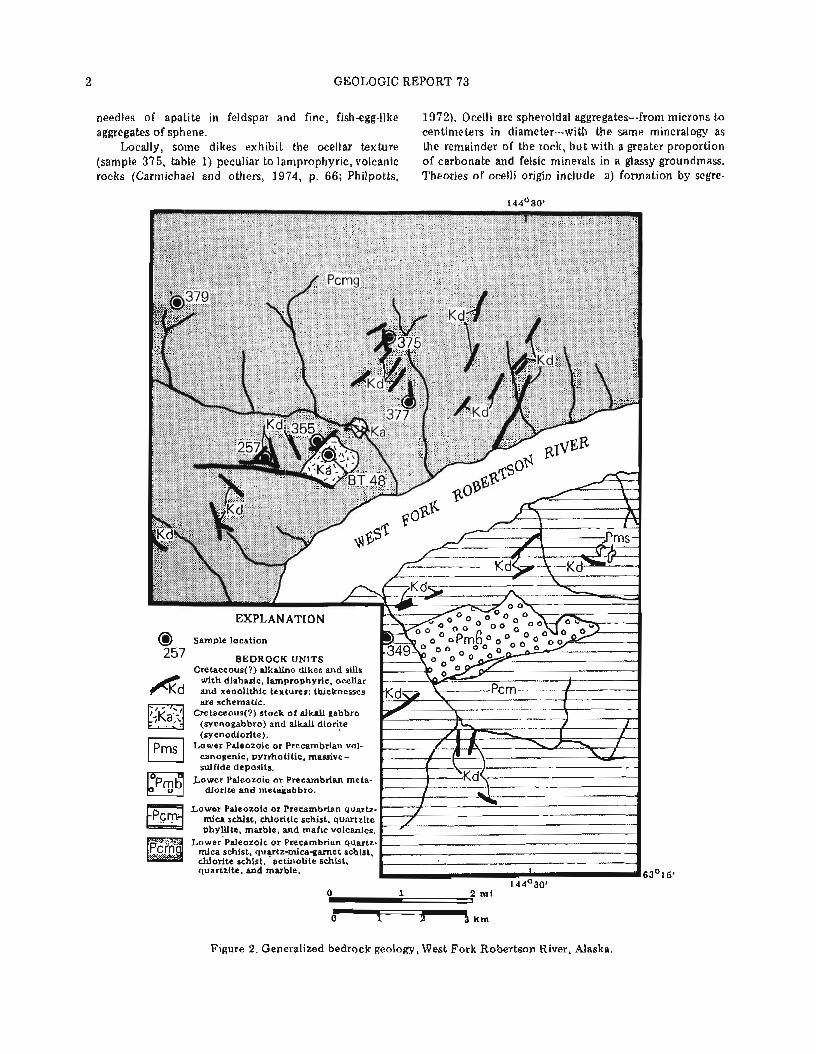
Previously unreported, alkaline igneous rocks occur in the eastern Alaska Range as two dike swarms, one near the West Fork of the Robertson River and another t o the east near the Tok River. These rocks intrude the underlying Precambrian and possibly younger, crystal- line metamorphic terrane and are believed to be the youngest igneous rocks in the area. A single potassium- argon age date ( 6 9 . 2 t 1.5 m.y .) on biotite indicates that a local, Late Cretaceous thermal event was associated with a stage of alkaline magmatism.
SUMMARY O F GEOLOGY
The upper West Fork of the Robertson River (figs. 1 , 2) drains a crystalline terrane consisting largely of polymetamorphic pelitic schists and associated meta- morphosed mafic flows. These rocks are correlated with the Birch Creek Schist (Mertie, 1937; Moffit, 1954; Richter and Jones, 1973) of Precambrian age (Wahrhaf- tig, 1968; Forbes, 1971). Mineral assemblages within the pelitic and mafic schists are restricted t o the greenschist facies, as defined by Winkler (1967, p. 88-106) and Miyashiro (1973, p. 67). Quartz-mica schist, is most abundant, with subordinate quartz-mica-garnet schist,
alkali gabbro and alkali diorite. The lamprophyre dikes are most common and typically strike northeast. This recurring strike direction is generally controlled by a northeast-striking joint set, but in some cases, the dikes are controlled by normal faults that are oblique to the joint set.
Although these alkaline igneous rocks show a wide range of textures, the most common is fine- t o medium- grained, panidiomorphic to porphyritic. Many narrow dikes and sills are continuous in strike and outcrop for tens of meters, bu t others bifurcate and show dis- continuous thicknesses ranging from centimeters to several meters. Mineralogically, these rocks contain euhedral biotite, augite, olivine, and occasional horn- blende in a groundmass of fine-grained plagioclase, potassium feldspar, and ankeritic carbonate with up to 5 percent euhedral ilmenite and magnetite (samples 257, 349, 355, 377; table 1). Alteration resulted in corrosion of mafic phenocrysts, and olivine typically displays a web texture characteristic o f serpentinization. Alteration products include chlorite and iron oxides after mafic minerals; pyroxene and olivine are replaced by antigorite, talc, and carbonate. Feldspars are ex- tensively fractured and replaced by carbonate along these fractures. Accessory minerals include abundant
chlorite-albite-epidote schist, actinolite schist, quartzite, and marble. These rocks are largely sedimentary in origin and contain minor mafic volcanic interlayers. A young- er(?) metavolcanic and metasedimentary section t o the east, between the Robertson and Tok Rivers, is as- sociated with the stratiform massive-sulfide deposits of the 'Delta Mineral Belt' (Clynton Nauman, oral com- mun.).
Large metamorphosed diorite and gabbro sills---up t o tens of meters thick---show relict, phaneritic igneous textures with metamorphic overprinting in the fonn of a weakly developed, preferred orientation of prismatic minerals. Postmetamorphic alkaline igneous rocks intrude the above-described lithologies.
PETROLOGY O F THE ALKALINE ROCKS
Potassic alkaline igneous rocks within the study area include a swarm of biotite-lamprophyre dikes and sills, associated breccia dikes, and a heterogeneous stock of
'u.s. Bureau of Mines, Fairbanks, Alaska 99701. Figure 1. Location o f study area in the east-central Mt.
Hayes Quadrangle, Alaska.
2 GEOLOGIC REPORT 73
needles of apatite in feldspar and fine, fish-egg-like 1972). Ocelli are spheroidal aggregates---from microns to aggregates of sphene. centimeters in diameter---with the same mineralogy as
Locally, some dikes exhibit the ocellar texture the remainder of the rock, but with a greater proportion (sample 375, table 1) peculiar to lamprophyric, volcanic of carbonate and felsic minerals in a glassy groundmass. rocks (Carmichael and others, 1974, p. 66; Philpotts, Theories of ocelli origin include a) formation by segre-
Figure 2. Generalized bedrock geology, West Fork Robertson River, Alaska.

Si02 Ti02 A120 3 ~ e 0 l MnO MgO CaO Na2O K20 P205 BaO SrO ~~0~ c o 2
257 Porphyritic,
panidiomorphic biotite-augite lamprophyre
47.50 0.85
10.10 8.20 0.16 8.70 9.20 2.70 1.60 0.15 0.15 0.08 8.60 5.00
Total
Table 1. Chemical analyses1 (wt %) and CIPW norms o f seven igneous rocks from Robertson River area.
349 Porphyritic
biotite- augite- olivine
lamprophyre
51.80 1.60
15.00 10.60 0.90 0.72 6.60 4.10 5.20 0.21 0.21 0.09 1.20 0.40
355 Porphyritic,
panidiomorphic biotite-augite-
olivine lamprophyre
51.80 1.10
10.90 8.70 0.14 9.10 8.30 2.50 3.90 0.15 0.15 0.07 0.80 0.10
375 Ocellar biotite- augite
lamprophyre
377 Porphyritic
biotite-augite- olivine lamprophyre
50.10 0.87
12.90 8.30 0.18 7.10 7.90 2.50 4.80 0.14 0.20 0.11 4.40 2.40
CIPW norms
Thornton-Tuttle Differentiation Index (Thornton and Tuttle, 1960)
379 Siliceous,
hornblende- porphyry
dike
BT48 Phaneritic
alkali diorite
l ~ e s o u r c e Associates of Alaska. Fairbanks, and Skyline Laboratories, Wheat Ridge, Colorado. 2 ~ 2 0 measured upon ignition at 1 0 0 0 ~ ~ ; total iron measured as FeO.
4 GEOLOGIC REPORT 7 3
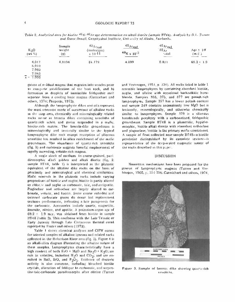
Table 2 . Analytical data for b io t i te 4 0 ~ - 4 0 ~ r age determination o n alkali diorite (sample BT48). Analysis b y D . L . Turner and Diane Duvall, Geophysical Insti tute, University o f Alaska, Fairbanks.
Sample 4 0 ~ r r a d 4 0 ~ r r a d K 2 0 weight (moles/gm)
(wt %) (9) x 10-11 4 0 ~ x
gation of residual magma that migrates into vesicles prior t o complete solidification of the host rock, and b) formation as droplets of immiscible feldspathic melt separate from a cooling basic magma (Carmichael and others, 1974; Philpotts, 1972).
Although the lamprophyric dikes and sills represent the most common mode of occurrence of alkaline rocks in the map area, chemically and mineralogically related rocks occur as breccia dikes containing xenoliths of quartz-rich schist and gneiss suspended in a mafic, biotite-rich matrix. The breccia-dike groundmass is mineralogically and texturally similar to the typical lamprophyric dike rock except resorption of siliceous xenoliths has resulted in silica enrichment of the mafic groundmass. The abundance of quartz-rich xenoliths (fig. 3) and carbonate suggests forceful emplacement of rapidly ascending, volatile-rich magma.
A single stock of medium- t o coarse-grained, pani- diomorphic alkali gabbro and alkali diorite (fig. 2; sample BT48, table 1 ) is interpreted as the plutonic equivalent of the alkaline dike rocks on the basis of proximity arld mineralogical and chemical similarities. Mafic minerals in the plutonic rocks include varying - -
proportions of biotite and augite; biotite is partly altered to chlorite and augite to carbonate, talc, and antigorite. Plagioclase and orthoclase are largely altered to car- bonate, sericite, and kaolin. Some coarse euhedral and twinned carbonate grains d o occur but replacement textures predominate, indicating a late paragenesis for the carbonate. Accessories include quartz, magnetite, ilmenite, olivine, and apatite. A potassium-argon age of 69.2 + 1.9 m.y. was obtained from biotite in sample ~ ~ 4 8 7 t a b l e 2). This conforms with the Late Triassic or Early Jurassic through Late Cretaceous thermal event reported by Foster and others (1973).
Table 1 shows chemical analyses and CIPW norms for selected samples of alkaline igneous and related rocks cpllected in the Robertson River area (fig. 2). Figure 4 is an alkali-silica diagram illustrating the alkaline nature of these samples. Lamprophyres characteristically have a high content of both FeO + MgO and Na20 + K 2 0 ; are rich in volatiles, including H 2 0 and C 0 2 ; and are en- riched in BaO, SrO, and P 2 0 5 Evidence of deuteric
total
and Verhoogen, 1951, p. 334). All rocks listed in table 1 resemble lamprophyres by containing abundant biotite, augite, and olivine with occasional barkevikitic horn- blende. Samples 355, 375, and 377 are potash-rich lamprophyres. Sample 257 has a lower potash content and sample 349 contains anomalously low MgO but is texturally, mineralogically , and otherwise chemically similar to lamprophyres. Sample 379 is a siliceous hornblende porphyry with a carbonatized, feldspathic groundmass. Sample BT48 is a phaneritic, hypidio- morphic, biotite-alkali diorite with abundant orthoclase and plagioclase; biotite is the primary mafic constituent. A sample of float collected near sample BT48---a biotite peridotite distinguished by its cumulate texture---is representative of the deep-seated magmatic source of the rocks described in this paper.
DISCUSSION
Numerous mechanisms have been proposed for the genesis of lamprophyric magmas (Tumer and Ver- hoogen, 1960, p. 254-256; Carmichael and others, 1974,
activity is also common, including bleached biotite crystals, alteration of feldspar to carbonate, and serpen- Figure 3. Sample of breccia dike showing quartz-rich tine-talc-carbonate pseudomorphs after olivine (Turner xenoliths.

SHORT NOTES ON ALASKAN GEOLOGY - 1 9 8 1 5
349. .BT 48 "1 ALKALINE
S i 0 2 (wt %)
Figure 4. Alkali-silica diagram (after Irvine and Bsragar, 1971) for seven rocks from Robertson River area, Alaska.
p. 508-510). Among these are differentiation from alkaline, olivine basaltic magmas, differentiation from granitic magmas, and assimilation of wall rock by magma. Most authors favor multiple modes of origin because lamprophyres have a wide range of composition; in fact, the term lamprophyre is generally texturally defined. A combination of these mechanisms may account for a specific variety of lamprophyre, and this may be the case with the alkaline rocks in the Robertson River area. I t is unclear what type of primary magma is responsible for the evolution of these rocks, but remelting of ferromagnesian minerals a t the base of a body of differentiating magma in the presence of a hydrous phase could account for alkali enrichment of the liquid phase and result in the production of abun- dant biotite with simultaneous crystallization of pyro- xene and olivine (Bowen, 1928, p. 258-273). I t is clear that a CO2-rich volatile phase played a significant role in the late-stage, deuteric alteration of these rocks. Ofte- dahl (1957) explains potassic lamprophyres as products of fusion of a shale roof by ho t gases emanating from an underlying magma. This hypothesis may account for the high content of BaO, SrO, H 2 0 , P205 , and CO2 char- acteristic of potassic lamprophyres and explains the high incidence of quartz-rich xenoliths in these rocks.
Mining Company and the University of Alaska School o f Mineral Industry assisted in paying for chemical anal- yses. Special thanks go t o T.K. Bundtzen for his con- tinuous aid and encouragement and thoughtful review, and t o reviewers J.T. Dillon, T.E. Smith, S.E. Swanson, and Clynton Nauman. Helpful comments were also offered by Paul Metz.
REFERENCES CITED
Bowen, N.L., 1928, Evolution of the igneous rock: Princeton, Princeton University Press, 332 p.
Carmichael, I.S.E., Turner, F.J., and Verhoogen, John, 1974, Igneous petrology: New York, McGraw-Hill, 739 p.
Forbes, R.B., 1971, Preliminary investigations of the petrology and structure of the Birch Creek Schist in the Fairbanks and Circle districts, Alaska: Geo- logical Society of America Bulletin, v. 71, no. 2, p. 2085.
Foster, H.L., Weber, F.R., Forbes, R.B., and Brabb, E.E., 1973, Regional geology of the Yukon-Tanana Upland, Alaska, in Pitcher, M.G., ed., Arctic geo- logy: American Association of Petroleum Geologists Memoir 19 , p. 388-395.
Irvine, T.N., and Baragar, W.R.A., 1971, A guide to the chemical classification of common volcanic rocks: Canadian Journal of Earth Science, v. 8 , p . 523-548.
Mertie, J.B., 1937, The Yukon-Tanana Region, Alaska: U.S. Geological Survey Bulletin 872, 276 p.
Miyashiro, Akiho, 1973, Metamorphism and meta- morphic belts: Great Britian, Unwin Brothers Limited, 492 p.
Moffit, F.H., 1954, Geology of the eastern Alaska Range and adjacent area: U.S. Geological Survey Bulletin 989-D, 218 p.
Oftedahl, C., 1957, Studies on the igneous rock complex o f the Oslo region, in Turner, F.J., and Verhoogen, John, 1960, Igneous and metamorphic petrology (2d ed.): New York, McGraw-Hill, p. 254-255.
Philpotts, A.R., 1972, Density, surface tension and viscosity of the immiscible phase in a basic, alkaline magma: Lithos, v. 5 , p. 1-18.
Richter, D.H., and Jones, D.J., 1973, Structure and stratigraphy of eastern Alaska Range, Alaska, in Pitcher, M.G., ed., Arctic geology: American As- sociation of Petroleum Geologists Memoir 19; p. 408-420.
Thornton, C.P., and Tuttle, O.F., 1960 , Chemistry of igneous rocks, I. Differentiation index: American Journal of Science, v. 268, p. 664-684.
Turner, F.J., and Verhoogen, John, 1951, Igneous and metamorphic petrology (1st ed.): New York,
ACKNOWLEDGMENTS McGraw-Hill, 602 p.
, 1960, Igneous and metamorphic petrology (2d ed.): New York, McGraw-Hill, 694 p.
Charles Green, James Mason, and Don Cannon, Wahrhaftig, Clyde, 1968, Schists of the central Alaska formerly with Asamera Oil, Inc., provided the author Range: U.S. Geological Survey Bulletin 1254-E, with the opportunity t o undertake this project. Asamera 22 p. Oil, Inc., provided logistical support during the 1978 Winkler, H.G.F., 1967, Petrogenesis of metamorphic field season. I thank Don Turner and Diane Duvall for rocks (2d ed.): New York, Springer-Verlag, 237 p. the potassium-argon age determination. Bear Creek

SHEAR MODULI AND DAMPING RATIOS FOR THE BOOTLEGGER COVE FORMATION AS DETERMINED BY RESONANT-COLUMN TESTING
By Randall G. Updikel, David A. Cole, Jr.2, and Cathy Uleryl
INTRODUCTION
The physical properties of soils underlying a site o r region have a profound influence on the response of that area to earthquakes. Techniques t o assess the dynamic behavior of soils during a seismic event have only re- cently approached the sophistication required t o assess the characteristics of site-specific response t o seismic- induced excitation; in fact, n o single technique provides the precise simulation of both in situ conditions and the responses of a soil sequence during a seismic event (Woods, 1978). Resonant-column testing, however, has proven instructive in determining the dynamic behavior of the Bootlegger Cove Formation, a glaciomarine clayey silt that underlies much of the Anchorage area.
The Bootlegger Cove Formation played a critical role in the ground failures that occurred in the bluffs within the city during the 1964 Prince William Sound earthquake. Although some studies were performed immediately after the earthquake (Shannon and Wilson, 1964), additional research was not conducted until recently (Updike and Carpenter, 1981). However, high seismic exposure and pressure for urban development are prompting renewed interest in the dynamic behavior of the Bootlegger Cove Formation and other sedimentary units. This paper is the result of one study t o develop siting criteria for the Anchorage community.
STRESS-STRAIN PROPERTIES O F SOILS
Predicting the response of the Bootlegger Cove Formation t o earthquake-loading conditions requires an understanding of the nonlinear stress-strain properties of individual sedimentary units during cyclic loading. Material properties that describe the dynamic behavior of a soil are its shear modulus and damping ratio. For small shear-strain amplitudes, the shear modulus is generally equal t o the mean slope of its stress-strain curve (secant modulus). However, as the level of strain increases, the stress-strain behavior becomes increasingly nonlinear ('softer'), and typically results in a marked de- crease in shear modulus. Similarly, material damping, o r the energy-absorbing characteristics of soil, is also strain dependent. Damping modeled in ground-response studies is generally expressed as a fraction of critical viscous
~ D G G S , Anchorage. Alaska 99501. DOWL Engineers. Anchorage, Alaska 99503.
damping, termed the damping ratio. The damping ratio for soil typically increases nonlinearly with increasing cyclic shear-strain amplitude. Shear strain developed in unconsolidated deposits during earthquakes may in- crease from about 10-3 percent during low-level ground shaking to 10-1 percent for strong motions. Within this range, nonlinear strain dependency is generally most pro- nounced; the lower part of that range (10-3<Y>10-1) is examined in this paper.
ENGINEERING-GEOLOGIC FACIES O F THE BOOTLEGGER COVE FORMATION
The Bootlegger Cove Formation is a clastic sedi- mentary unit of late Pleistocene (-14,000 years B.P.) age (Schmoll and others, 1972). Formerly referred t o as the 'Bootlegger Cove Clay,' the formation actually consists of silt with some clay and fine sand. Recent research (Updike, 1981) indicates that the various sedimentary facies that constitute the formation developed in re- sponse t o subtle changes in the glaciomarine depositional environment. Each facies is the product of a distinct set of depositional and postdepositional environmental factors, and retains a characteristic suite of mappable engineering properties.
Engineering geologic facies defined within the Bootlegger Cove Formation include: a) F.I., clay, with very minor silt and sand; b) F.11, silty and/or clayey silt; c) F.111, silty clay and/or clayey silt, sensitive; d) F.IV, silty clay and/or clayey silt, with thin silt and sand lenses; e) F.V, silty clay and/or clayey silt, with random pebbles; f) F. VI, silty fine sand with silt and clay layers; and g) F.VII, fine t o medium sand, with traces of silt and gravel.
Data from engineering tests conducted over the past 25 yr were processed t o establish characteristic static properties for each facies (table 1). The only dynamic testing of the formation was the Shannon and Wilson (1964) cyclic triaxial testing.
SAMPLING AND TEST PROCEDURE
Test samples were taken from a site in downtown Anchorage that is typical of that part of the city, name- ly, it is not directly influenced by free-face topography and has not had landslide failures.
IJndisturbed core samples from several boreholes
8 GEOLOGIC REPORT 73
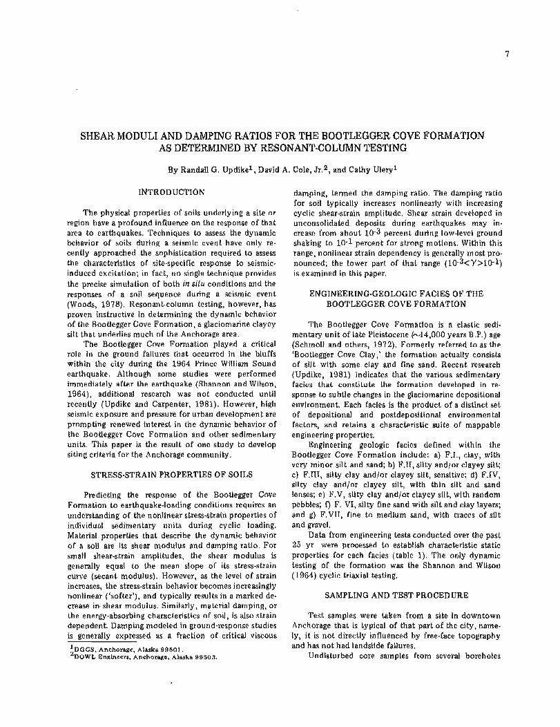
were collected in modified Shelby tubes a t prespecified depths. The cores were extracted by Alaska Testlab, and routine soils classification and indexes, including Tor- vane, pocket penetrometer, moisture content, and Atterberg limits, were obtained. Some samples were selected for more advanced testing. The liquid limit (WL), plastic limit (Wp), and natural moisture content (WN) were determined in the DGGS Anchorage labora-
Figure 1. Composite geotechnical profile of two bore- holes a t downtown Anchorage sampling site (eleva- tion 100.5 f t above mean sea level). Central column of graph shows Atterberg Limits (Wp = plastic limit, WN = natural moisture content, WL = liquid limit).
Table 1. Mean values o f physical parameters o f engineer- inggeologic facies, Bootlegger Cove Formation.
NOTE: np-nonplastlc, nu-nonviscous, ns-nonsensitive, nd-no data ava~lable
FACIES ,
Mean gram slze (mml
Moisture content 1%)
tory. A representative engineering geologic-soils profile of the site was made from field and laboratory logs, facies discrimination, and Atterberg limits (fig. I).
Undisturbed samples of the major facies beneath the site were selected for resonant-column testing from two boreholes. The samples were hand carried to the Hard- ing-Lawson Laboratories in Novato, California, for testing.
The heart of the testing apparatus is the Harding Oscillator, which vibrates a cylindrical column of soil in a torsional mode a t very small amplitudes (fig. 2). The frequency of vibration was changed until resonance in the soil column occurred. A sinusoidal signal supplied by an Exact function generator was fed into a Hewlett- Packard 50-watt power amplifier; the amplified signal drove the oscillator. The output signal from an accelero- meter on the oscillator was amplified through a Colum- bia Research Laboratory charge amplifier and was fed, along with some of the amplitude of the driving signal, into a Tektronix storage oscilloscope, where input and output frequencies were compared and matched at resonance.
Six test samples were prepared by trimming the Shelby tube sample t o a diameter of 2.46 in. and a length of 6.00 in., enclosing it in a membrane, and placing it in the test apparatus, where it was allowed t o consolidate for 48 hr. Each sample was subjected to isotropic consolidation based on a calculated effective overburden pressure a t the depth of sample recovery. A uniform soil density of 1 3 0 lb/f t3 and saturated condi- tions below a depth of 18 ft were assumed. Water exuded from the sample during the consolidation phase was measured. During the consolidation process, the vertical pressure (01) was increased above the assumed confining pressure by 300 lb/f t2 to achieve proper coupling between the oscillator and the sample.
After consolidation occurred, the actual test began when a small-amplitude signal was applied t o the oscil- lator. Oscillation frequency was altered until resonance, when accelerometer-amplitude output , resonant fre- quency, and driving signal were recorded. The test continued a t various induced amplitudes. The damping
I
0.0014
29.8
I I
0.004
28.4
i l l
0.004
29.8
IV
0.015
28.0
V
0.006
28.5
VI
0.15
25.0
Vll
0.37
29.1

SHORT NOTES ON ALASKAN GEOLOGY - 1 9 8 1 9
coefficient was determined by turning off the driving (2) The shear modulus of the soft cohesive facies signal and allowing the oscillation to decay. This decay (F.111) decreases when the soil is remolded. After re- was recorded on the storage oscilloscope screen and a molding, sample RC-1 appears to have lost signifi- logrithmic decrement was calculated. After each test, an cant moisture during reconsolidation. Thixotropic undrained and unconfined triaxial compression test was hardening may have influenced the increased remolded performed on the sample t o establish its undrained shear shear modulus of sample RC-1. strength (7 , figs. 3-10). (Because a very low level of (3) At low values of strain ( to about 10-2 percent), strain was induced during resonant-column testing, we the damping ratio is consistently about 2 percent of assume the triaxial compression tests were performed on critical, regardless of facies. This suggests the formation undisturbed samples.) On completion of these tests, each is uniform with respect t o damping for moderately sample was weighed t o determine field density and dried strong shaking. to obtain natural moisture content (WN). Samples RC-1 and RC-5 were thoroughly remolded---to destroy the ACKNOWLEDGMENTS original soil structure---before they were tested in the same manner as the undisturbed samples. All samples are The Alaska Division o f Emergency Services (ADES) stored in the DGGS Anchorage laboratory. funded this project as part of a grant from the Federal
Emergency Management Agency. The perception of RESULTS long-term needs in earthquake-hazard preparedness by
Col. Ed Newberry, Harold Wolverton, Christie Miller, Six samples subjected to r~sonant-column testing and Duane Bessette, all of ADES, is appreciated. The
represent facies F.11, F.111, and F.V (figs. 3-10). FaCies Earthquake Hazard Reduction Program of the U.S. F.1 occurred in layers too thin for testing and facies F.IV was abundant in the upper half of the formation but was considered too inhomogeneous for this study. Sample RC-5 (facies F.11) is from a distinct horizon in a part of the section that, on the larger scale, is indicated as facies F.IV; it is typical of the upper Bootlegger Cove Forma- tion.
Aside from the direct application of the curve-to- response analysis, the following general conclusions are supported:
(1) Shear-moduli curves for the undisturbed speci- mens of facies F.11 and F.111 are quite similar. At a given strain, the shear modulus for facies F.V is about twice that of the other facies, which probably reflects a more rigid soil fabric or a higher degree of consolidation or both.
Figure 2. Resonant-column instrument array used in study. .\ - Tektronix storage oscilloscope, B - Exact-function generator, C - Hewlett-Packard power amplifier, D - Co1,~mbia Research charge amplifier, E - Harding resonant- column apparatus, F - Undisturbed sample, Bootlegger Cove Formation.

10 GEOLOGIC REPORT 73
Shear Strain I % \
Shear Strain (%I
IN IT IAL F INAL
32 6 1891 1 ;:;. 7200
72roo ! Undisturbed Eleld molsture - - - -
Shear Stra~n I % )
Shear Strain I%)
IN IT IAL F I N A L
I 7500, 7200 - I -
--
[ ~ 5 ! 0 _ - L- - --
Y
Figure 3. Shear modulus and damping-ratio results for Figure 4. Shear modulus and damping-ratio results sample RC-5, facies F.11, in situ condition. for sample RC-5, facies F.11, remolded condition.
. .
Shear Strain (%) --
FACES F 1 1 1 INITIAL F I ~ A L Sample number Molrture content (%I 36 7 Dry dens~ty b c f ) 85 4 d1,63~Cps', _ -
Und~sturbedlremolded Undrsturbed
Shear Strain (%)
Shear Strain (%I
Figure 5. Shear modulus and damping-ratio results Figure 6. Shear modulus and damping-ratio results for sample RC-1, facies F.111, in situ condition. for sample RC-1, facies F.111, remolded condition.

SHORT NOTES ON ALASKAN GEOLOGY - 1981 11
Shear Strain (%I
FACIES ~ l l l l Sample number
Dry dens~ty (pcf) 853 --
Figure 7. Shear modulus and damping-ratio results for sample RC-2, facies F.111, in situ condition.
- m 4 - z
I
- I
i5 0 1
Shear Stra~n (%I
. - Shear Strain (%I
GcIES-F v: - TNITIAL F&AC_J Sample number_- - . ~ o ~ s t x c o n t e n t l % ~ 1 -- 257 - - i 3 r ~ dens~ty (pcf) - - I;% -,- 1003 _ _ I , ca,Ipsfl - 'A385 10,080 C r ( p s f 1 T X U U - 4000 Und~sturbed/remolded_ Und~sturbed- ~~eld-mo~sturelsaturated F ~ l d ~ s t u ~ _ _
$ 4 7 * J L ~ [ t t - x I , 3 1 ~
- ~ . I 1 I
5 2 4 - I
I
1 Shear Straln (%)
,Shear Strain (%)
IN IT IAL ' FINAL
- --
Figure 8. Shear modulus and damping-ratio results for sample RC-3, facies F.V, in situ condition.
Shear Strain (%I
Figure 9. Shear modulus and damping ratio for sample Figure 10. Shear modulus and damping ratio for sample RC-4, facies F.111, in situ condition. RC-7, facies F.V, in situ condition.

GEOLOGIC REPORT 73
Geological Survey also contributed to the project. The authors especially thank DOWL Engineers, Anchorage, and Harding-Lawson Engineers, Novato, California, for their technical support. This report was reviewed by R.D. Reger, DGGS, and Hans Pulpan, University of Alaska, Fairbanks.
REFERENCES CITED
Schmoll, H.R., Szabo, B.J., Rubin, Meyer, and Dobro- volny, Ernest, 1972, Radiometric dating of marine shells from the Bootlegger Cove Clay, Anchorage area, Alaska: Geological Society o f America Bul- letin, v. 83, no. 4, p. 1107-1114.
Shannon and Wilson, 1964, Report on Anchorage area soil studies, Alaska: Seattle, Washington, Shannon and Wilson, Inc., 1 0 9 p.
Updike, R.G., 1981, Engineering geologic maps, Govern- ment Hill area, Alaska: U.S. Geological Survey I-series maps [in press].
Updike, R.G., and Carpenter, B.A., 1981 , Engineering geology of the Government Hill area, Anchorage, Alaska: U.S. Geological Survey Bulletin [in press].
Woods, R.D., 1978, Measurement of dynamic soil proderties: American Society of Civil Engineers, Geotechnical Division, Conference on Earthquake and Soil Dynamics, Pasadena, Calif., 1978, Pro- ceedings, v. 1 , p. 91-178.

CLINOPTILOLITE AND MORDENITE DEPOSITS OF POSSIBLE ECONOMIC VALUE AT ILIAhlNA LAKE, ALASKA
By James A. Madonna1
INTRODUCTION
In the early 1970's, the increased industrial use of zeolites stimulated the search for commercial zeolite deposits in Alaska. As a result, extensive zeolitized volcanic tuffs were located in the upper Matanuska Valley (Hawkins, 1973), and Tertiary tuffs and tuff- aceous sedimentary rocks containing zeolites were identified on the Alaska Peninsula near Iliamna Lake (Madonna, 1973). This report describes the potentially economic clinoptilolite- and mordenite-bearing tuffs and tuffaceous sediments a t the latter location.
BACKGROUND
Mumpton (1973) classified zeolites according to environment of formation as follows:
a) from volcanic material in 'closed' systems of ancient and present-day saline lakes,
b) from volcanic material in 'open' systems of freshwater lakes or ground-water systems,
c) from volcanic material in nearshore o r deep-sea marine environments,
d) by low-grade burial metamorphism of volcanic and other material in thick sedimentary sequences,
e) by hydrothermal o r hot-spring activity, and f) in lacustrine or marine environments without
direct evidence of volcanic precursor material. Zeolite formation is favored by the presence of
fluids of high pH and high alkali- to hydrogen-ion ratios in contact with reactive silicate material such as vitric volcanic tuff. Deffeys (1959) suggested that zeolites form in sedimentary tuff deposits by solution of vol- canic glass followed by precipitation of the zeolite from solution. Sheppard (1971) suggested that high pH conditions account for the solubility of the glass and that reactivity of alkali ions is responsible for precipita- tion of the zeolites.
Because zeolites are extremely porous, hydrous mineral phases of low specific gravity, they are parti- cularly sensitive to pressure and temperature changes, which accounts for the vertical zonation often found in thick sequences of tuffaceous sediments. The most hydrous and least dense zeolites form in the lower
pressure-temperature conditions---at the top of the sequence---and the least hydrous and most dense zeolites form in the higher pressure-temperature conditions a t the bottom of the sequence. Alteration due t o burial diagenesis proceeds from fresh glass to clinoptilolite and mordenite t o analcime and heulandite and finally t o laumontite. The zeolites become unstable with increased pressure and temperature, and are ultimately trans- formed t o minerals such as the feldspars.
These observations suggest that four conditions must be met before extensive sedimentary zeolitization and preservation are possible:
a) presence of reactive parent material such as vitric tuff,
b) presence of 'active' fluids such as marine, saline- lake, or hydrothermal waters,
c) passage of a geologically short time span, so that previously formed metastable zeolites have not been altered t o more stable mineral phases, and
d) relatively shallow burial, so that burial dia- genesis has not transformed the metastable zeolites into more stable mineral phases.
These conditions are diagrammatically shown in figure 1. Zeolite formation and preservation are most
. . . . I . . . . . . . RI:AC'I'IVI: .. . . . . • • PARES'I' IZI.\TEItIAI. ..* . .. .
• (vitric tuffs) • • . . . .: . . . . . . . ' .* . . . . . . . . . a . . . *. . . -.
. . • (shallow burial) • . . ..................................
' ~ l a s k a n Prospectors and Geologists supply, Fairbanks, Alaska Figure 1. Diagram showing conditions which favor sedi- 99701. mentary zeolite formation and preservation.

1 4 GEOLOGIC REPORT 7 3
favored when all four conditions are simultaneously satisfied.
DISCUSSION
The search for zeolites in the Iliamna area was restricted t o those lithologic units that satisfy the basic conditions for zeolite formation and preservation (Madonna, 1973, 1975). Selected samples collected in 1972 were analyzed by X-ray diffraction techniques and several highly zeolitized units along the south shore and in the foothills bordering Iliamna Lake were thus identified (fig. 2).
EXPLANATION
A Mordenite
Clinoptilolite
I Heulandite
0 No zeolites present
LOCATION MAP
Z
. *
164~30'
area
The 1972 investigation of Tertiary andesites, tuffs, and tuffaceous sediments revealed several rock units with high concentrations of clinoptilolite and mordenite, but the extent of the zeolite-bearing lithologies was no t realized until 1975, when a more thorough investigation was conducted. Figure 2 shows sample locations and general outcrop limits of the more extensively zeolitized rocks.
The most promising of several volcanic tuff and tuffaceous sedimentary units that crop ou t along Iliamna Lake is a 20-ft-thick, green, fine-grained, altered tuff bed (sample 1) exposed for 1 5 0 f t along the lake shore. Favorable analytical results (Madonna, 1975) and
I I 1 154O30' 0 H 1 mi
Figure 2. Sample locations and zeolitized units, southern shore o f Lake Iliamna, Alaska.
SHORT NOTES ON ALASKAN GEOLOGY - 1981
moderate areal extent suggest this deposit may be an economic source of mordenite.
Of almost equal interest are the mordenite-bearing volcanic tuffs that crop out a t sample points 2 and 21. Similar physical and mineralogical characteristics, including their light-green color, the presence of abun- dant spherical structures that indicate agitation in an aqueous environment, and the high concentration of mordenite (Madonna, 1975), suggest these outcrops are part of the same tuff bed. In addition, strike and dip measurements indicate the beds are on the respective east and west limbs of a gently folded north-south- trending anticline. This interpretation is further sup- ported by the presence of anticlinally folded Tertiary sediments along the lakeshore between the two mor- denite-bearing units (samples 3-14). Both units are approximately 1 5 f t thick and are exposed for about 1 0 0 f t along the lake shore. The high zeolite concentra- tion and apparent large areal extent suggest that these units may also be of economic interest.
Other zeolitized tuffaceous sediments are exposed along the lake shore and in a small, southeast-trending tributary (samples 5-9). The sediments vary from fine- grained tuffaceous siltstone t o reworked volcaniclastics and rough, bouldery, tuffaceous conglomerates. As indicated above, the sediments are exposed in a gently folded, north-south-trending anticline.
The most important zeolitization is found in three clinoptilolite-bearing tuffaceous sandstones and re- worked volcaniclastic units (samples 5-7) exposed as a combined 60-ft-thick sequence in a small southeast- trending drainage. Although clearly exposed within the limits of the drainage and t o a somewhat lesser extent along the lakeshore, extensive vegetation prevented accurate measurement of the length and width of the units. However, a conservative estimate from the ob- served outcrops suggests a 112-mi length along the lakeshore and a 114-mi width along the drainage. This deposit may be an economic source of clinoptilolite; however, a more extensive evaluation is required.
The foothills adjacent t o the lake's southern shore (samples 15-19) and near the zeolitized units described above consist of green clinoptilolite- and mordenite- bearing vitric and welded tuffs. These units are easily measured because of their position above tree line and the general lack of vegetation. Observed dimensions include an overall length of 314 mi, a width of about 113 mi and an average thickness of 4 0 0 ft. The com- paratively high concentrations of clinop tilolite and mordenite determined by mineralogical tests (Madonna, 1975) and their respectable outcrop dimensions suggest that these units may be among the more important zeolite-bearing tuffs in the Iliamna area.
GENESIS O F THE DEPOSITS
The clinoptilolite- and mordenite-bearing lithologies exposed along the southern lake shore and in the small
southeast-trending drainage consist of nonmarine re- worked volcanics and water-laid tuffs. However, the zeolite-bearing vitric tuffs exposed in the adjacent foothills d o not exhibit characteristics typical of an aqueous environment; in fact, their stratigraphic position and high elevation suggest terrestrial deposition.
The clinoptilolite and mordenite deposits were formed by the alteration of this volcanic material. The mineralogy, mode of occurrence, and depositional environment suggest that these zeolites were produced in 'open' systems of fresh-water lakes or ground-water systems (type b, Mumpton's classification). In addition, the presence of the clinoptilolite-mordenite assemblage indicates a low-temperature, low-pressure environment above the zone of significant alteration caused by burial diagenesis.
CONCLUSIONS
Favorable results of mineralogical examinations of selected samples (Madonna, 1975) and the rather large aerial extent of the zeolite-bearing tuffs and tuffaceous sediments suggest they may be of economic interest as a future source of clinoptilolite and mordenite.
ACKNOWLEDGMENTS
I wish t o thank D.B. Hawkins, Professor of Geology, University of Alaska, and M.A. Wiltse, Geochemist, DGGS, for their thoughtful reviews of the manuscript.
REFERENCES CITED
Deffeys, K.S., 1959, Zeolites in sedimentary rocks: Journal of Sedimentary Petrology, v. 1 9 , p. 602- 609.
Detterman, R.L., and Reed, B.L., 1968, Geology of the Iliamna Quadrangle, Alaska: U.S. Geological Survey Open-file Report 300.
Hay, R.L., 1966. Zeolites and reactions in sedimentarv rocks: Geological Society of America Special Paper 85, 1 3 0 p.
~ a w k i n s , D.B., 1973, Sedimentary zeolite deposits of the upper Matanuska Valley, Alaska: Alaska Divi- sion of Geological and Geophysical Surveys Special Report 6 , 1 7 p.
Madonna, J.A., 1973, Zeolite occurrences in Alaska: Fairbanks, University o f Alaska, unpublished M.S. thesis.
, 1975, Zeolite deposits of possible economic significance on the northern Alaska Peninsula: Alaska Division of Geological and Geo- physical Surveys Open-file Report 87, 27 p.
Mumpton, F.A., 1973, Worldwide deposits and utiliza- tion of natural zeolites: Industrial Minerals, no. 73, 11 p.
Sheppard, R.A., 1971, Zeolites in sedimentary deposits of the United States, a review in Gould, R.F., ed., Molecular sieve zeolites-1: American Chemical Society, Advances in chemistry, series 101, p. 179- ' 310.


THE KEETE INLET THRUST FAULT, PRINCE OF WALES ISLAND
By Earl Redmanl
INTRODUCTION REFERENCES CITED
'I'he Keete Inlet thrust fault, located in the Craig Herreid, Gordon, 1975, Geologic map of the ~ r a i g A-2 A-2 Quadrangle on southern Prince of Wales Island, was Quadrangle, Prince of Wales Island, Alaska: Alaska
originally mapped and described by Herreid (1975). On Division of Geological and Geophysical Surveys Open-file Report 35, 1 pl.
the basis of outcrops along the west side of Keete Inlet, Gordon, Bundtzen, T.K., and Turner, D.L., Herreid and others (1978) concluded that the fault 1978, Geology and mineral deposits of the Craig forms the contact between the pre-Ordovician Wales A-2 Quadrangle and vicinity, Prince of Wales Island, Group greenschist and the overlying Descon Formation Alaska: Alaska Division of Geological and Geo- and Devonian bedded rocks. physical Surveys Geologic Report 48, 49 p.
Peek, B.C., 1975, Geology and mineral deposits of the DISCUSSION Niblack Anchorage area, Prince of Wales Island,
Alaska: Fairbanks, University of Alaska unpublished
Regional geologic mapping during a 1975-76 recon- M.S. thesis, 50 p.
naissance minerals-exploration program extended the Turner, D.L., Herreid, Gordon, and Bundtzen, T.K.9 1977, Geochronology of southern Prince of Wales
Keete Inlet thrust fault south to lower Klakas Inlet and Island, Alaska: Alaska Division of Geological and east t o Port Johnson (fig. 1). During mapping, the Geophysical Surveys Geologic Report 55, p. 11-16. juxtaposition of Wales Group rocks with Descon Forma- tion and Devonian rocks was observed; the fault plane itself was not identified in outcrop.
The fault plane has a southeast-plunging synclinal form. Dips are shallow, varying from 250 t o 400 SE (Herreid and others, 1978). The Niblack area---a window through the Descon Formation into the Wales Group greenschist---may have been created by doming of the Wales Group along the Dolomi-Sulzer arch (Peek, 1975). The plane of the fault is moderately contorted, as shown by the abrupt change in direction near Port Johnson and the presence of the Niblack window.
Herreid and others (1978) note pervasive shearing of the Wales Group up to 450 m from the fault. In the Ruth BayIKlakas Inlet area, several hundred meters of the Wales Group adjacent to the fault are strongly silicified, but overlying rocks are unaffected.
T o date, the age of the Keete Inlet thrust fault is defined only by the Devonian rocks involved in the thrusting and by the Cretaceous intrusive rocks (Turner and others, 1977) that intrude the fault. However, during my field work, I identified two undated granitic plutons that cu t the fault.
ACKNOWLEDGMENTS
The reviewing efforts of John Decker and T.K. Bundtzen are appreciated.
'c .c . Hawley and Associates, Juneau, Alaska 99801.

Figure 1. The Keete Inlet thrust fault, Prince of Wales Island, Alaska.
GEOLOGIC REPORT 73
13 2'30'

TWO I-IOLOCENE MAARS IN TI-IE CENTRAL ALASKA RANGE
By Mary D. Albanesel
GEOLOGIC SETTING
The study area is underlain by the California Creek Member of the Totatlanika Schist, a quartz-orthoclase- sericite schist and gneiss metarhyolite of Mississippian age. This unit is overlain locally by the Lignite Forma- tion and the Nenana Gravel, both of Tertiary age, and Pleistocene t o Recent alluvium.
The study area is situated above a Benioff zone (strike N. 480 W., plunge northwest) near the Denali fault. Holocene maars occur a t the northeast corner of this zone, above the 125-km depth contour of the subduction zone (Agnew, 1979).
DESCRIPTION
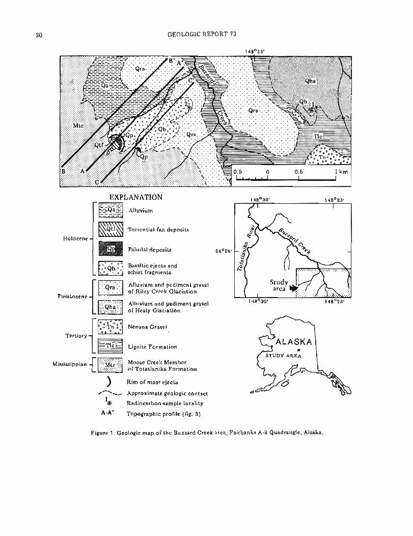
T w o adjacent craters located southwest of Buzzard Creek, a tributary of the Totatlanika River on the north flank of the central Alaska Range (fig. I ) , have been identified as maars. The floors of the craters are broad and shallow (fig. 2) and are bounded by a semicircular rim consisting of about 80 percent angular schist frag- ments and 20 percent subrounded vesicular-basalt ejecta ranging from cinders t o blocks. An ejecta blanket can be traced a distance of 1.1 km northeast of the larger crater. Each crater contains a small pond.
The larger crater was previously identified as a cinder cone from a late Pleistocene or Holocene volcanic eruption (Pe'w; and others, 1966). However, a recent study suggests the craters are probably maars, which are defined as shallow, broad, low-rimmed explosion craters formed by phreatic and phreatomagmatic eruption (Ollier, 1967; Lorenz, 1973).
ORIGIN
The semicircular shape of the craters and rims and the presence of basaltic ejecta suggest that the craters are volcanic features. During the eruption of a maar o r tuff ring, large volumes of steam and water vapor are re- leased and spread ejecta away from the vent. The craters produced under these conditions are broad, shallow features with characteristic height- to-width ratios of 1: 10 t o 1:30 (Ileiken, 1971). This ratio apparently does not apply t o extremely young or currently active maars, such as the Ukinrek Maars, which erupted in 1977 and
'DGGS, College, AK 99708
resulted in a height-to-width ratio of 1:4 (Kienle and others, 1980). Purely magmatic eruptions containing little o r n o water for steam generation often produce cinder cones during lava fountaining. The resultant craters are steeply sloping depressions in large mounds of volcanic ejecta; height-to-width ratios vary from 1: 5 t o 1:16. The ratio of 1:22 for the larger crater a t Buzzard Creek suggests that the crater is a maar or tuff ring.
The primary distinction between maars and tuff rings is that maars form below the preeruption surface as negative features, whereas tuff rings form above the preeruption surface as positive features. According t o Lorenz (1973), this difference is a function of the depth of the eruption source. The preeruption surface of the larger crater a t Buzzard Creek can be inferred from the slope of the surrounding terrain (fig. 3). Superposition of profiles B and C onto profile A, which bisects the crater, shows the height of the crater relative to the land surface on either side. The preeruption surface can be inferred along profile A by removing the ejecta blanket and extending this surface upslope, using a slope similar to profiles B and C. This inferred preeruption surface suggests that the larger crater is a negative feature.
Because the eruption source for maars is deeper than that of tuff rings, a greater percentage of country rock participates in the eruption. According t o Lorenz (1973), maar ejecta may contain more than 6 0 percent country rock, whereas tuff-ring ejecta often consist o f less than 1 0 percent country rock. As stated earlier, the rim material a t the Buzzard Creek craters consists of about 8 0 percent country rock and 20 percent vesi- cular-basalt ejecta, suggesting a maar-eruption origin.
Lorenz (1973) also inferred that tuff rings generally form above the water table, whereas maars form near o r below the water table and frequently contain small lakes. The fact that both craters a t Buzzard Creek contain ponds also supports a maar-eruption origin.
AGE O F BASALTIC EJECTA
Three samples of charcoal from above and below basaltic ejecta from the larger crater were radiocarbon dated a t Krueger Enterprises, Inc., Geochron Lab- oratories Division, Cambridge, Massachusetts (fig. 1 , table 1). The samples from belbw the basaltic ejecta yield a mean age of 3,140 + 230 yr B.P.; a sample from directly above the ejecta-yields a radiocarbon age of 2,910 t 230 y r B.P. These dates indicate that the
GEOLOGIC REPORT 73
EXPLANATION
Alluvium
Torrential-fan deposits
Holocene
I Paludal deposits
Basaltic ejecta and schist fragments
I- Alluvium and pediment gravel of Riley Creek Glaciation
Pleistocene Alluvium and pediment gravel ..... of Healy Glaciation
1iml Nenana Gravel
Tertiarv
" 1 k q Lignite Formation
. . . . . . . . . . . . . . . . . . . . . . . . . . . . . . . . . Mississippian I:;:: ~t~ ;:;:; Moose Creek Member
. . . . . . . . . . . {E] of Totatlanika Formation
) Rim of maar ejecta
/-'-- Approximate geologic contact 1
Radiocarbon-sample locality
A-A' Topographic profile (fig. 3)
ALASKA STUDY AREA
Figure 1. Geologic map of the Buzzard Creek area, Fairbanks A-3 Quadrangle, Alaska.

SHORT NOTES ON ALASKAN GEOLOGY - 1 9 8 1
Table 1. Ages of basaltic ejecta in the Buzzard Creek area, central Alaska Range, Alaska.
Sample Sample Age * weight
no. Description ( 1 4 ~ yr) (mg) Stratigraphic position
1 Charcoal 2910 5 230 5 0 Dark humus layer a t base of 1.6-cm-thick layer of modern organic material that overlies 2 cm of basaltic ejecta.
2 Charcoal 3585 5 235 110 Discontinuous, organic layer up t o 1.2 cm thick overlain by a 41-cm-thick layer of basaltic ejecta.
3 Charcoal 2695 5 220 5 0 Duplicate sample from same unit as above.
*Dates based on Libby half-life (5,570 yr) for radiocarbon. Error stated is + l u a s judged by analytical data. Age is referenced t o A.D. 1950.
Figure 2. Aerial view of craters a t Buzzard Creek, look- ing west. Photo by R.D. Reger, September 1978.
I i - - Proi~ le A-A' bisects the larger r rd ler and rlnl
Proflle 9-B' IS locared about 500m NW o i p m f ~ l c A.A' --- Prorile C-C' 1s loeared about 500m SE rrf profl ie A-A '
'.. ... Inferred preeruptton surface along profi le A-A' deter. m ~ n e d by ~ u b l r a c r ~ n g the elecra lblanket and projectme the rlape upward
0 " -
0 7 -
. " , 0 0 5 I 0 1 5 2 0 2 5
I i o r v ronu l dtsrance (kml
(Approxlmale verllcal exaggeration 1 2)
Figure 3. Topographic profiles and inferred preeruption surface in Buzzard Creek area, Fairbanks A-3 Quad- rangle, Alaska.
basalt was erupted about 3,000 - + 230 radiocarbon yr B.P.
CONCLUSIONS
Evidence that the larger crater formed below the preeruption surface, the high percentage of country rock within the crater-rim material, and the proximity of both craters to the water table suggest that t h e ' t w o craters a t Buzzard Creek are maars. Radiocarbon dates indicate that the larger maar was formed about 3,000 + 230 yr B.P. The smaller maar was probably formed a t about the same time.
ACKNOWLEDGMENTS
This paper was condensed from the author's Master of Science thesis (Albanese, 1980). Funding for the project was provided by U.S. Department of Energy contract EW-78-5-07-1720. Field assistance was provided by Edward Ross. The manuscript was reviewed by D.L. Turner, W.G. Gilbert, R.D. Reger, and J.R. Riehle. Early drafts were reviewed by Juergen Kienle and S.E. Swan- son. Reger also provided valuable assistance in the field.
REFERENCES
Agnew J.D., 1979, Seismicity of the central Alaska Range: Alaska Science Conference, 30th, Fairbanks, 1979, Proceedings, p. 73.
Albanese, M.D., 1980, The geology of three extrusive bodies in the central Alaska Range: Fairbanks, University of Alaska, unpublished M.S. thesis, 1 0 1 p.
Heiken, G.W., 1971, Tuff rings, examples from south- central Oregon: Journal of Geophysical Research, v. 76, no. 27, p. 6516-6526.
Kienle, Juergen, Kyle, P.R., Self, Stephen, Motyka, R.J., and Lorenz, Volker, 1980, Ukinrek Maars, Alaska, April 1977 eruption sequence, petrology, and tectonic setting: Journal of Volcanology and Geothermal Research, v. 7 , no. 1 , p. 11-37.

2 2 GEOLOGIC REPORT 73
Lorenz, Volker, 1973, On the formation of maars: Geologic map of the Fairbanks Quadrangle, Alaska: Bulletin Volcanologique, v. 37, no. 1, p. 183-204. U.S. Geological Survey Miscellaneous Geological
Ollier, C.D., 1967, Maars: their characteristics, varieties, Investigations Map 1-455, scale 1:250,000. and definition: Bulletin Volcanologique, v. 31, Wahrhaftig, Clyde, 1970, Geologic map of the Fairbanks no. 1 , p. 45-73. A-3 Quadrangle, Alaska: U.S. Geological Survey
P Q w ~ , T.L. Wahrhaftig, Clyde, and Weber, F.R., 1966, Geological Quadrangle Map GQ-809, scale 1:63,360.
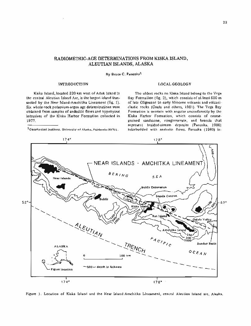
RADIOMETRIC-AGE DETERMINATIONS FROM KISKA ISLAND, ALEUTIAN ISLANDS, ALASKA
By Bruce C. Panuskal
INTRODUCTION LOCAL GEOLOGY
Kiska Island, located 320 km west of Adak Island in the central Aleutian Island Arc, is the largest island tran- sected by the Near Island-Amchitka Lineament (fig. 1). Six whole-rock potassium-argon age determinations were obtained from samples of andesitic flows and hypabyssal intrusives of the Kiska Ilarbor Formation collected in 1977.
'~eophysical Institute, University of Alaska, Fairbanks 99701.
The oldest rocks on Kiska Island belong t o the Vega Bay Formation (fig. 2), which consists of a t least 600 m of late Oligocene t o early Miocene volcanic and volcani- clastic rocks (Coats and others, 1961). The Vega Bay Formation is overlain with angular unconformity by the Kiska Harbor Formation, which consists of coarse- grained sandstone, conglomerate, and breccia that represent braided-stream deposits (Panuska, 1980) interbedded with andesite flows. Panuska (1980) in-
Figure 1. Location of Kiska Island and the Near Island-Amchitka Lineament, central Aleutian Island arc, Alaska.
GEOLOGIC REPORT 73
1 7 7 " 35'
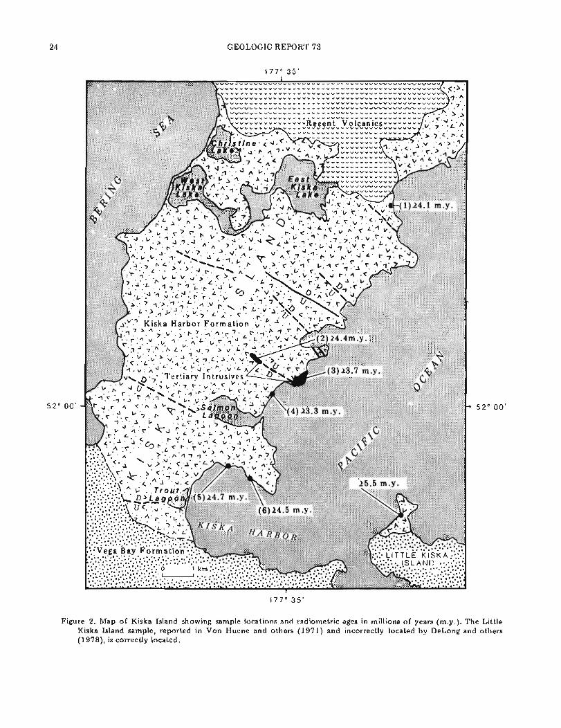
Figure 2 . Map of Kiska Island showing sample locations and radiometric ages in millions of years (m.y.). The Little Kiska Island sample, reported in Von Huene and others (1971) and incorrectly located by DeLong and others (1978), is correctly located.

SHORT NOTES ON ALASKAN GEOLOGY - 1 9 8 1 2 5
formally subdivided the formation into a lower and upper unit on the basis of paleocurrent direction, depositional environment, and sedimentary petrology. The northern end of the island is capped by recent flows of the active Kiska Volcano.
RADIOMETRIC AGE DATA
Figure 2 shows the location and age of the daled samples (table 1). Except for sample 1 and the Little Kiska Island sample collected by W.J. Carr and Leonard Gard of the U.S. Geological Survey and determined t o be 5.5 m.y. by Richard Marvin (also with the USGS), all reported ages are minimum because alteration may have released argon.
Sample 1 was collected from an andesite lava flow in the upper Kiska Harbor Formation and provides a reliable age of 4.1 m.y. Sample 2 was collected from a dike intruded along a fault that cuts the hypabyssal intrusive from which sample 3 was collected. The 4.4-m.y.-minimum age of sample 2 and geological
relationships (fig. 3) require that the 3.7-m.y- minimum age for sample 3 is a t least 0.7 m.y. too young.
The same fault-dike relationship that limits the age of sample 3 appears t o limit the age of sample 4 , which was collected from a lava flow in the upper Kiska Harbor Formation that appears t o be cut by the same fault. The age determination for sample 4 (3.3-m.y. minimum) thereby appears t o be a t least 1.1 m.y. too young. Alternatively, if the material adjacent t o the fault breccia is interpreted as talus breccia (fig. 3), the intru- sive may have been faulted and uplifted, exposing the intrusion to mechanical weathering that resulted in the accumulation of slide rock as a talus-breccia apron. If these events were followed by sedimentation and erup- tion of the lava flow, the 3.3-m.y.-minimum age o f sample 4 could be correct.
Samples 5 (4.7-m.y.-minimum age) and 6 (4.5- m.y.-minimum age) were collected from an andesite flow near the base of the upper Kiska Harbor Formation. These samples date the minimum age of the onset of upper Kiska Harbor Formation deposition at 4.7 m.y.
Sample 2 24.4 m.y. Dike intruded along fault
SECTION OF EAST COAST
OF KlSKA ISLAND
sample 4
Figure 3. Sea-cliff exposure near hypabyssal intrusive on Kiska Island, central Aleutian Island arc, Alaska.

GEOLOGIC REPORT 73
Table 1 . Whole-rock ~ O K - ~ O A ~ ages o f andesitic flows and hypabyssal intrusives
Sample 4 0 ~ r (rad) 40Ar (rad) 40Ar (rad)
K2O wt (moles/gm) 40Ar Age 2 1(T Sample (wt %) (g) x 10-11 4 0 ~ x 10-3 total (m.y.1
0.415 4.4 + 0.1 - minimum
age
0.664 3.7 + 0.1 minimum
age
0.690 3.8 + 0.1 - minimum
age
0.145 4.7 + 0.1 - minimum
age
0.582 4.5 + 0.1 -
minimum age
*Analytical error corresponds to uncertainty of + 0.1 m.y.
The 5.5 (L0.7)-m.y. age from Little Kiska Island was began a t least 4.4 m.y. ago. Ground breaks along the obtained from a lava flow a t the base of the Kiska same trend have been observed; in fact, a probable fault Harbor Formation. This age was originally reported by scarp that cuts a 1962 lava flow suggests current activ- Von Huene and others (1971) and incorrectly located by ity. DeLong and others (1978). The location is correctly reported here (Leonard Gard, written commun., 1978). ACKNOWLEDGMENTS
CONCLUSIONS This paper was reviewed by D.L. Turner and John Decker. Their constructive criticism and valuable sugges.
These radiometric-age data and the previously tions are gratefully acknowledged. The radiometric-age reported 5.5-m.y. date on Little Kiska Island indicate determinations were provided by Turner. Without these that the Kiska Harbor Formation is late Miocene t o early data this paper would not have been possible. Pliocene in age. The lower Kiska Harbor Formation braided-stream sediments were deposited 5.5 to 4.7 m.y. ago, and normal faulting of the Kiska Harbor Formation

SHORT NOTES ON ALASKAN GEOLOGY - 1981
REFERENCES CITED
Coats, R.R., Nelson, W.II. , Lewis, R.Q., and Powers, H.A., 1961, Geologic reconnaissance of Kiska Island, Aleutian Islands, Alaska: U.S. Geological Survey Bulletin 1028-R, p. 563-581.
DeLong S.E., Fox, P.J., and McDowell, F.W., 1978, Subduction of the Kula Ridge a t the Aleutian Trench: Geological Society of America Bulletin, v, 89, no. 1 , p. 83-95.
Panuska, B.C., 1980, Stratigraphy and sedimentary petrology of the Kiska Harbor Formation and its relationship to the Near Island-Amchitka Linea- ment, Aleutian Islands: Fairbanks, University of Alaska, unpublished M.S. thesis, 9 0 p.
Von Huene, Roland, Carr, W.J., Mcmanus, Dean, and Holmes, Mark, 1971, Marine geophysical study around Amchitka Island, western Aleutian Islands, Alaska, Amchitka-22: U.S. Department of Com- merce, National Technical Information Service AT(29-2)-474-74, 3 5 p.


GEOCHEMICAL SIGNATURE OF TI-IE GOON DIP GREENSTONE ON CHICHAGOF ISLAND, SOUTHEASTERN ALASKA
By John Decker1
INTRODUCTION
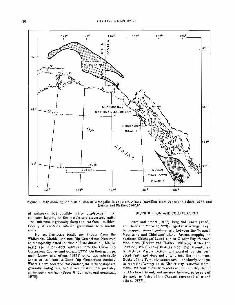
Many geologists believe that Alaska and western Canada are composed of a mosaic of discrete tectono- stratigraphic terranes, each with a characteristic strati- graphic sequence and unique geologic history (Berg and others, 1978; Tipper, 19'78; Jones and others, 1981). One of the most extensive terranes is Wrangellia (Jones and others, 1977), which consists predominantly of a distinctive Middle and Upper Triassic sequence of tholeiitic basalt overlain by inner-platform carbonate (fig. 1). Alternate models for the distribution of Wran- gellia in southeastern Alaska have been proposed by Brew and Morrell (1979), Plafker and Hudson (1980), and Decker and Plafker (1981a,b). This report sum- marizes geologic data and presents new geochemical data on the Wrangellia section on Chichagof Island. This information supports the correlation of the Chichagof Island section with similar strata in the type area of Wrangellia.
STRATIGRAPHY
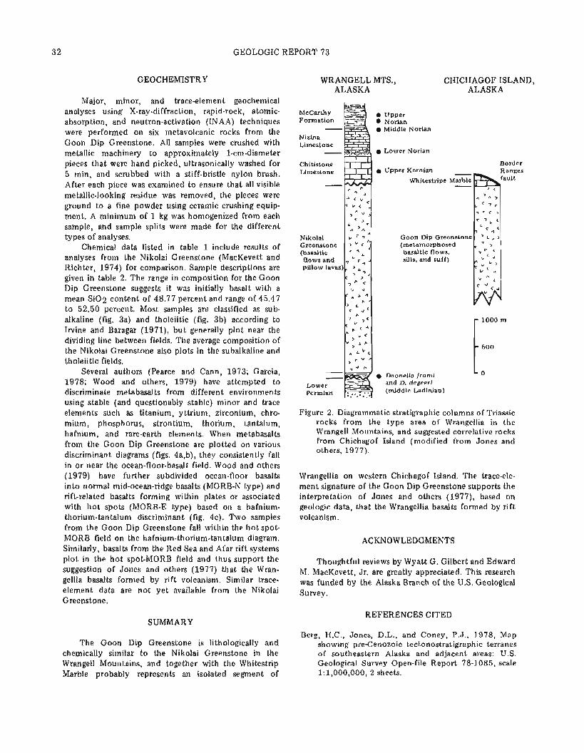
In its type area in the Wrangell Mountains, the Triassic sequence of Wrangellia consists of four forma- tions, the Nikolai Greenstone, the Chitistone Limestone, the Nizina Limestone, and the McCarthy Shale. The Nikolai Greenstone is a thick, weakly deformed se- quence of predominantly subaerial, but locally pillowed basalt of Middle and/or Late Triassic age. I t generally unconformably overlies late Paleozoic volcaniclastic rocks and limestone, but locally overlies grayish-black chert, siltstone, and shale of Middle Triassic (Ladinian) age. The Chitistone Limestone disconformably overlies the Nikolai Greenstone and consists of inner-platform carbonate rocks that grade upward into open-platform and basinal carbonate rocks of the Nizina Limestone; both limestone units are of Late Triassic age. The Nizina Limestone is conformably overlain by the McCarthy Shale, a sequence of calcareous shale, chert, and lime- stone of Late Triassic and Early Jurassic age (Jones and others, 1977, 1981).
On the basis of a striking lithologic similarity, Plafker and others (1976) first suggested that the Goon Dip Greenstone and Whitestripe Marble on western
'DGGS, College, Alaska 99708.
Chichagof Island are correlative with the Nikolai Green- stone and Chitistone Limestone, respectively (fig. 2).
The Goon Dip Greenstone is generally massive, medium-gray-weathering, medium- t o dark-gray and greenish-gray, very fine grained, plagioclase- (or rarely pyroxene-) porphyritic basalt and metabasalt. The rocks are dominantly holocrystalline, commonly amyg- daloidal, and locally pillowed. Flow breccia, pillow breccia, and crystal-lithic lapilli tuff are less common; diabase dikes are rare. Locally, the rocks have a very weakly developed metamorphic foliation. One particu- larly well-preserved exposure of the Goon Dip Green- stone (near the top of Whitestripe Mountain) consists of thick-bedded t o massive ( 1 to 2 m thick), shallow, westward-dipping flow units. The amygdaloidal tops, vertical pipe amygdules near the base of flows, and red tuffaceous interbeds together consistently indicate tops t o the west, toward the Whitestripe Marble. The lack of pillows, presence of red beds, and amygdaloidal char- acter suggest subaerial volcanism.
The Goon Dip Greenslone has been affected by two periods of metamorphism. The first period produced a regional low-temperature-facies series characterized by mineral assemblages that indicate recrystallization during conditions of the prehnite-pumpellyite and lower greenschist facies. The second period of metamorphism was a thermal overprint that was localized in contact aureoles around Upper Jurassic and Lower Cretaceous plutons, and produced predominantly hornblende hornfels and rarely pyroxene hornfels facies mineral assemblages.
The Whitestripe Marble is generally massive to weakly foliated, white to medium-gray, fine-grained marble. Recrystallization of the Whitestripe Marble produced a peculiar neomorphic texture and color that Augustus K. Armstrong (oral commun., 1979) of the U.S. Geological Survey has seen only in the lower part o f the Chitistone Limestone. The neomorphic similarities between the Whitestripe Marble and the Chitistone Limestone are probably due to similar thermal meta- morphic histories and no t necessarily t o similar deposi- tional environments. Locally, the marble includes diorite dikes and greenstone interbeds, lenses, and clasts. Where observable, crude layering within the marble also has a shallow westward dip.
The contact between the Whitestripe Marble and the Goon Dip Greenstone is a steep westward-dipping fault
30 GEOLOGIC REPORT 73
148O 144O 140° 136' 132O 128'
6Z0
62O
58O 58'
CHICHAGOF
128O
54O 54O
148O 144O 140° 136' 13Z0
Figure 1. Map showing the distribution of Wrangellia in southern Alaska (modified from Jones and others, 1977, and Decker and Plafker, 1981b).
of unknown but possibly minor displacement that truncates layering in the marble and greenstone units. The fault zone is generally sharp and less than 1 m thick. Locally it contains foliated greenstone with marble clasts.
No age-diagnostic fossils are known from the Whitestripe Marble o r Goon Dip Greenstone. However, an isotopically dated tonalite of Late Jurassic (150-164 m.y.) age is probably intrusive into the Goon Dip Greenstone (Loney and others, 1975). On their geologic map, Loney and others (1975) show two migmatite zones a t the tonalite-Goon Dip Greenstone contact. Where I have observed this contact, the relationships are generally ambiguous, but a t one location it is probably an intrusive contact (Bruce R. Johnson, oral commun., 1979).
DISTRIBUTION AND CORRELATION
Jones and others (1977), Berg and others (1978), and Brew and Morrell (1979) suggest that Wrangellia can be mapped almost continuously between the Wrangell Mountains and Chichagof Island. Recent mapping on northern Chichagof Island and in Glacier Bay National Monument (Decker and Plafker, 1981a,b; Decker and Johnson, 1981) shows that the Goon Dip Greenstone - Whitestripe Marble section is truncated by the Peril Strait fault and does not extend into the monument. Rocks of the Tarr Inlet suture zone---previously thought t o represent Wrangellia in Glacier Bay National Monu- ment---are continuous with rocks of the Kelp Bay Group on Chichagof Island, and are now believed t o be part of the melange facies of the Chugach terrane (Plafker and others, 1977).
SHORT NOTES ON ALASKAN GEOLOGY - 1981
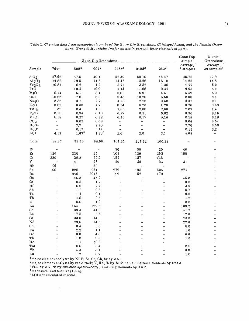
Table 1. Chemical data from melavolcanic roclzs o f the G o o n Dip Greenslone, Chichagof Island, and !he Nikolai Green- stone, Wrangell Mountains (major oxides in percent, tracc elements in p p m ) .
Goon Dip Greenstone - -- -
Sample 764' 60g2 6 0 4 ~ 245c3 240d3 2533
SiO2 A1203 Fe203 FeO MgO CaO Na2O K20 T i02 p205 MnO (302 H20+ H20- LO1
Goon Dip sample
Average, 6 samples
Nikolai Greenstone
Average, 39 samples4
Total 99.37 99.75 98.90 101.31 101.62 100.88 --
N i -- -- -- 50 50 20 4 0 Zr 126 230 95 104 126 252 155 Cr 230 35.8 70.2 157 137 < I 3 - - Y 4 1 2 8 20 3 2 33 3 1 Rb <5 11 5 0 -- -- --
Sr 6 0 228 254 279 194 626 274 Ba 240 2215 < 9 152 170 -- Co -- 46.5 45.2 -- 45.8 Cs -- 0.3 1.2 -- -- 0.8 Hf -- 5.6 2.2 -- -- -- 3.9 Sb -- 1.1 0.3 -- -- 0.7 Ta -- 1.4 0.4 0.9 Th 1.8 0.6 -- -- -- 1.2
u -- 0.6 1 .O -- -- -- 0.8 Zn -- 154 122.5 -. 138.2 Sc -- 39.4 44.0 -- -- -- 41.7 La 17.5 6.5 -- -- 12.0 Ce -- 33.5 14 -- -- 23.8 Nd -- 29.5 14.5 -- -- -- 22.0 Sm -- 8.4 3.6 -- -- 6 .O Eu -- 2.2 1.1 -- 1.6 Gd -- 8.0 4 .O -- -- -- 6.0 Tb 1.8 0.8 -- 1.3 Ho -- 1.1 <0.6 -- -- -- -- Tm -- 0.6 0.4 -- -- 0.5 Y b -- 4.4 3.1 -- -- -- 3.8 Lu -- 1.2 0.7 1 .O lMajor element analyses by XRF; Zr, Cr, Rb, Sr by AA. 2 ~ a j o r element analyses by rapid rock; Y, Rb, Sr by XRF; remaining trace elements by INAA. 3 ~ e 0 by AA, Ni by emission spectroscopy, remaining elements by XRF. 4 ~ a c ~ e v e t t and Richter (1974). 5~~~ not calculated in total.
GEOLOGIC REPORT 73
GEOCHEMISTRY
Major, minor, and trace-element geochemical analyses using X-ray-diffraction, rapid-rock, atomic- absorption, and neutron-activation (INAA) techniques were performed on six metavolcanic rocks from the Goon Dip Greenstone. All samples were crushed with metallic machinery t o approximately 1-cm-diameter pieces that were hand picked, ultrasonically washed for 5 min, and scrubbed with a stiff-bristle nylon brush. After each piece was examined t o ensure that all visible metallic-looking residue was removed, the pieces were ground to a fine powder using ceramic crushing equip- ment. A minimum of 1 kg was homogenized from each sample, and sample splits were made for the different types of analyses.
Chemical data listed in table 1 include results of analyses from the Nikolai Greenstone (MacKevett and Richter, 1974) for comparison. Sample descriptions are given in table 2. The range in composition for the Goon Dip Greenstone suggests it was initially basalt with a mean S i 0 2 content of 48.77 percent and range of 45.47 t o 52.50 percent. Most samples are classified as sub- alkaline (fig. 3a) and tholeiitic (fig. 3b) according to Irvine and Baragar (1971), but generally plot near the dividing line between fields. The average composition of the Nikolai Greenstone also plots in the subalkaline and tholeiitic fields.
Several authors (Pearce and Cann, 1973; Garcia, 1978; Wood and others, 1979) have attempted to discriminate metabasalts from different environments using stable (and questionably stable) minor and trace elements such as titanium, yttrium, zirconium, chro- mium, phosphorus, strontium, thorium, tantalum, hafnium, and rare-earth elements. When metabasalts from the Goon Dip Greenstone are plotted on various discriminant diagrams (figs. 4a,b), they consistently fall in or near the ocean-floor-basalt field. Wood and others (1979) have further subdivided ocean-floor basalts into normal mid-ocean-ridge basalts (MORB-N type) and rift-related basalts forming within plates or associated with ho t spots (MORB-E type) based on a hafnium- thorium-tantalum discriminant (fig. 4c). Two samples from the Goon Dip Greenstone fall within the ho t spot- MORB field on the hafnium-thorium-tantalum diagram. Similarly, basalts from the Red Sea and Afar rift systems plot in the ho t spot-MORB field and thus support the suggestion of Jones and others (1977) that the Wran- gellia basalts formed by rift volcanism. Similar trace- element data are not yet available from the Nikolai Greenstone.
SUMMARY
The Goon Dip Greenstone is lithologically and chemically similar t o the Nikolai Greenstone in the Wrangell Mountains, and together with the Whitestrip Marble probably represents an isolated segment of
WRANGELL MTS., ALASKA
McCarthy Formation -
Nizina Limestone -
Chitistone Limestone
Nikolai Greenstone (basaltic flows and pillow lavar
Upper Norian Middle Norian
Lower Norian
CHICHAGOF ISLAND, ALASKA
Rorder Upper Karnian - Ranges
Whitestripe Marble -
Goon Dip Greensta (metamorphosed basaltic flows, sills, and tuff)
Daonella fromi and D. degeeri (middle Ladinian)
Figure 2. Diagrammatic stratigraphic columns of Triassic rocks from the type area of Wrangellia in the Wrangell Mountains, and suggested correlative rocks from Chichagof Island (modified from Jones and others, 1977).
Wrangellia on western Chichagof Island. The trace-ele- ment signature o f the Goon Dip Greenstone supports the interpretation of Jones and others (1977), based on geologic data, that the Wrangellia basalts formed by rift volcanism.
ACKNOWLEDGMENTS
Thoughtful reviews by Wyatt G. Gilbert and Edward M. MacKevett, Jr. are greatly appreciated. This research was funded by the Alaska Branch of the U.S. Geological Survey.
REFERENCES CITED
Berg, H.C., Jones, D.L., and Coney, P.J., 1978, Map showing pre-Cenozoic tectonostratigraphic terranes of southeastern Alaska and adjacent areas: U.S. Geological Survey Open-file Report 78-1085, scale 1:1,000,000, 2 sheets.

SHORT NOTES ON ALASKAN GEOLOGY - 1981
I I I I I I I / - Irvine and Baragar (1971) 1
4 I F FeO + 0 . 8 9 9 8 F e 2 0 3 A A Goon Dip Greenstone
A N a 2 0 + K 2 0 Q Nikolai Greenstone
M MgO (Average. 3 9 samples) 8 - -.- Kuno (1966)
6 - -
4 - -
2 -
(Average, 39 samples) 0 I I I I I I
3 5 4 0 4 5 5 0 55 6 0 65 7 0
THOLEIITIC / Q: \
/ CALC-ALKALINE \
SiOZ (weight percent)
Figure 3. Classification of basalts. Metabasaltic rocks from the Goon Dip Greenstone are subalkaline (fig. 3a) when plotted o n an S i 0 2 versus total alkalies (K2O + Na20) diagram, and tholeiitic (fig. 3b) when plotted on an F-A-M diagram using the discriminant lines by Irvine and Baragar (1971).
Table 2. Description o f melavolcanic rocks analyzed from the Goon Dip Greenstone
FIELD DESCRIPTION THIN-SECTION DESCRIPTION Sample number Metamorphic minerals - Relict features
massive, fine-grained, highly fractured greenstone
calcite, epidote, actinolite, chlorite
holocrystalline, very fine-grained; aphyric, no relict minerals
thick-bedded, fine- grained greenstone
calcite, epidote, chlorite
holocrystalline, fine- grained; aphyric, no relict minerals
fine-grained green- stone interlayered with marble; pillow basalt nearby
no thin section no thin section
massive, fine- t o medium-grained basalt(?)
prehnite, actinolite holocrystalline, fine- grained; altered plagio- clase
massive, fine-grained, altered basalt
epidote, actinolite, chlo- rite, quartz
holocry stalline, fine- grained; plagioclase, highly altered clinopyroxene, magnetite
amygdaloidal, porphyritic basalt
calcite, epidote; with chlorite, pumpellyite amygdules
holocrystalline, fine- grained; plagioclase, clino- pyroxene, magnetite

GEOLOGIC REPORT 73
r l / l u u Island-arc tholeiites I\
A Normal MORB (N-type) B Hotspot MORB (E-type) C Within-plate basalts D Plate-margin basalts
D
Hf13-Th-Ts d y r a m of W o o d and others (1979)
Th Ta 4c.
A Island-arc tholeiites B Calc-alkaline basalts C Ocean-floor basalts
Zr Sr/2
15 4' OCEAN-FLOOR BASALTS
Tier plot of CveL, 1978
0 100 200 300 400 500
Cr (ppm)
4d.
l l l l I 1 1 1 1 1 1 1
- -
- OCEAN-FLOOR BASALTS
- -
CALC-ALKALINE BASALTS
T i G Ti-Zr plot of Garcia. 1WLl
Figure 4(a-e). Classification of basaltic rocks according t o tectonic environment based on minor and trace-element geochemistry. See Hill (1979) or Garcia (1978) for a discussion of confidence and validity of using these dia- grams for altered rocks.

SHORT NOTES ON ALASKAN GEOLOGY - 1981 3 5
Brew, D.A., and Morrell, R.P., 1979, The Wrangell terrane ('Wrangellia') in southeastern Alaska: The Tarr Inlet suture zone with its northern and south- ern extensions, in Johnson, K.M., and Williams, J.R., eds., United States Geological Survey in Alaska: Accomplishments during 1978: U.S. Geo- logical Survey Circular 804-B, p. B121-B123.
Decker, John, and Johnson, B.R., 1981, The nature and position of the Border Ranges fault on Chichagof Island, in Albert, Nairn, and Hudson, Travis, eds., United States Geological Survey in Alaska: Accom- plishments during 1979: U.S. Geological Survey Circular 823-B, p. 102-104.
Decker, John, and Plafker, George, 1981a, Correlation of the Tarr Inlet suture zone, southeastern Alaska: Geological Association of Canada Abstracts, v. 6 , p. A-1 4
Survey of Canada Paper 66-15, p. 317-336. Loney, R.A., Brew, D.A., Muffler, L.J.P., and Pomeroy,
J.S., 197 5, Reconnaissance geology of Chichagof, Baranof, and Kruzof Islands, southeastern Alaska: U.S. Geological Survey Professional Paper 792, 1 0 5 p.
MacDonald, G.A., and Katsura, T., 1964, Chemical composition of Hawaiian lavas: Journal of Petro- logy, v. 5, p. 82-133.
MacKevett, E.M., Jr. , and Richter, D.H., 1974, The Nikolai Greenstone in the Wrangell Mountains, Alaska and nearby areas: Geological Association of Canada, Cordilleran Section, Program and Abstracts, p. 13-14.
Pearce, J.A., anti Cann, J.R., 1973, Tectonic setting of basic volcanic rocks determined using trace element analyses: Earth and Planetary Science Letters, v. 19 , - - - -.
, 1981b, Correlation of rocks in the p. 290-300. Tarr Inlet suture zone with the Kelp Bay Group, in Plafker, George, and Hudson, Travis, 1980, Regional Coonrad, W.L., ed., United States Geological Survey implications of Upper Triassic metavolcanic and in Alaska: Accomplishments during 1980: U.S. metasedimentary rocks on the Chilkat Peninsula, Geological Survey Circular 844, p. 119-122. southeastern Alaska: Canadian Journal of Earth
Garcia, M.O., 1978, Criteria for the identification of Sciences, v. 17, p. 681-689. ancient volcanic arcs: Earth Science Reviews, v. 14 , Plafker, George, Jones, D.L.9 Hudson, Travis, Berg, H.C., w . 147-165. 1976, The Border Ranges fault system in the Saint
Hill, M.D., 1979, Volcanic and plutonic rocks on the Kodiak-Shumagin shelf, Alaska: Subduction de- posits and near-trench magmatism: Santa Cruz, University of California, unpublished Ph.D. thesis, 259 P.
Irvine, T.N., and Baragar, W.R.A., 1971, A guide t o the chemical classification of the igneous rocks: Cana- dian Journal of Earth Science, v. 8 , p. 523-548.
Jones, D.L., Silberling, N.J., Berg, H.C., and Plafker, George, 1981, Tectonostratigraphic terrane map of Alaska: U .S. Geological Survey Open-file Report 81-792, 20 p.
Jones, D.L., Silberling, N.J., and Hillhouse, J.W., 1977, Wrangellia--a displaced terrane in northwestern North America: Canadian Journal of Earth Sciences, v. 1 4 , no. 11 , p. 2565-2577.
Kuno, H., 1966, Lateral variation of basalt magma across continental margins and island arcs: Geological
Elias Mountains and Alexander Archipelago, in Cobb, E.H., ed., United States Geological Survey in Alaska: Accomplishments during 1975: U.S. Geo- logical Survey Circular 733, p. 14-16.
Plafker, George, Jones, D.L., and Pessagno, E.A., Jr., 1977, A Cretaceous accretionary flysch and melange terrane along the Gulf of Alaska margin, in Blean, K.M., ed., United States Geological Survey in Alaska: Accomplishments during 1976: U.S. Geo- logical Survey Circular 751-B, p. B41-B43.
Tipper, H.W., 1978, Tectonic assemblage map of the Canadian Cordillera: Geological Survey of Canada Open-file Report 572, scale 1:2,000,000.
Wood, D.A., Joron, Jean-Louis, ancl Treuil, Michel, 1979, A reappraisal of the use of trace elements t o classify and discriminate between magma series erupted in different tectonic settings: Earth and Planetary Science Letters, v. 45, p. 326-336.


URANIUM MINERALIZATION IN THE NENANA COAL FIELD, ALASKA
By Robert K. Dickson
INTRODUCTION
The Tertiary coal-bearing group in the Nenana Coal Field was intensively prospected for uranium between 1974 and 1979. Although mineralization was discovered, the potential for economic deposits is considered quite low.
Three types of uranium mineralization were dis- covered: a) a small roll-front system near Jumbo Dome, b) a fracture coating in micaceous schist, and c) an epigenetic, tabular deposit in conglomeratic sands a t Dexter Creek (fig. 1). The labular deposit is of greatest interest because of its high grade, more favorable acces- sibility, and potential value in interpretation of the depositional environment.
GEOLOGIC SETTING
The geology of the Nenana Coal Field has been described in detail by Wahrhaftig (1958, 1970a-b, 1973), Wahrhaftig and others (1969), and Triplehorn (1976). Figure 1 is a generalized geologic map of the study area and figure 2 is a stratigraphic column.
The Tertiary coal-bearing group unconformably overlies Paleozoic metasediments and metavolcanics that are assigned t o the Birch Creek Schist, Totatlanika Schist, and Keevy Peak Formations. The basal unit of the coal-bearing group is the upper Oligocene - lower Miocene Healy Creek Formation, a sequence of fluvial conglomeratic sandstones interbedded with claystones and subbituminous coal. The Healy Creek Formation is conformably overlain by the Sanctuary Formation, a locally thick lacustrine claystone that is overlain---in places unconformably---by the middle Miocene Sun- trana Formation, which is lithologically similar t o the Healy Creek Formation. The Lignite Creek Formation, a fluvial sequence of arkosic conglomerates, claystones, and coal, conformably overlies the Suntrana Formation in most places, but local unconformities are present. The most recently deposited unit of the coal-bearing group is the upper Miocene Grubstake Formation, which consists of siltstone and claystone with interbedded sands and locally reworked ash beds. The coal-bearing group is unconformably overlain by the Pliocene Nenana Gravel.
A northern provenance is inferred for the coal- bearing group, primarily because of the presence of
'~rangesellschaft U.S.A., Inc., Denver, Colorado 80222
abundant black chert. No chert is reported locally and the most likely source is the Yukon-Tanana Upland. Garnet in the Suntrana Formation also suggests a north- ern source.
Two lithologic changes are indicative of climatic cooling and a decrease in chemical weathering from older t o younger formations. First, clay mineralogy changes from dominantly kaolinite in the Healy Creek Formation t o dominantly montmorillonite in the Suntrana Formation and above. Second, pebbles in the Healy Creek and Suntrana Formations are more resistant than those of the arkosic Lignite Creek Formation.
URANIUM MINERALIZATION
Three types of uranium mineralization were dis- covered: a) a roll-front system, b) a fracture coating or filling in micaceous schist, and c) a tabular occurrence in conglomeratic sands.
The roll-front system was discovered during drilling in Suntrana and Healy Creek Formation sediments north of Jumbo Dome (fig. 1). Altered tongues extend from a canyon that was incised in these formations (fig. 3) and later filled with very permeable Lignite Creek Formation conglomerates. Probable sources of uranium are the ash beds in the Grubstake Formation or intraformational tuffaceous material. The Lignite Creek Formation is an excellent conduit for oxidizing ground waters. These waters invaded the canyon walls and deposited uranium along the reduction-oxidation boundary of the geo- chemical cells. The highest grade mineralization included 3 f t of 0.016 percent eU3082. The extreme depth of the anomalies (400-700 ft) and difficult drilling conditions complicated their evaluation.
The second type of mineralization is located in the Lignite Creek drainage and occurs in fractured and oxidized micaceous Birch Creek Schist. The first indica- tion of mineralization was a strong anomaly in stream- sediment and water samples. A fractured and oxidized schist outcrop with 79 ppm U3O8---about 1 0 times the observed background value---was located. The most probable origin for this occurrence is percolation of mineralized ground water from overlying Healy Creek Formation sediments that have since been removed by
'~quivalent uranium, defined as the apparent amount of uranium as calculated from the gamma-ray emission of 2 1 4 ~ , according to Levinson (1980, p. 696).

38 GEOLOGIC REPORT 73
149O00' ALASKA
'.
Study location Approximate Mem Dcelirution, 1955
Figure 1. Geologic map of the study area, after Wahrhaftig (1970a,b).

SHORT NOTES ON ALASKAN GEOLOGY - 1981
EXPLANATION
Q " . t e r n ~ *]luvium .<...'.~,~,'.. , ;
~ ~ ~ ~ ~ t " , { Volcanic rocks
m1 c . . , %I Nenana Gravel
Tertiary
Grubstake Formation
Tg and TIC
Lignite Creek Formation
Suntrana Formation
Sanctuary Formation
Intrusive and volcanic rocks
pre-Tertiary f pre-Tertiary rocks, including Keevy Peak Formation, Birch Creek Schist, and Totatlanika Schist Formations
--- Contact, dashed where approximate
- - Fault, dashed where covered
URANIUM OCCURRENCE
@ Roll front north of Jumbo Dome
@ Fracture concentration near Lignite Creek
@ Dexter Creek tabular occurrence

4 0 GEOLOGIC REPORT 73
erosion. The uranium mineralogy and exact mode of
Nenono Grovel occurrence were not determined.
Grubstake Fo rma t~on The third and most significant type of uranium
reference sect~on mineralization is a tabular deposit that crops out along Dexter Creek in the headwaters of the Totatlanika River (fig. 1). Airborne radiometry and stream-geochemistry reconnaissance detected anomalies that led to the discovery of a 2-ft-thick mineralized zone in the basal Healy Creek Formation; values ranged up to 0.17 percent U 3 0 8 in 'high-graded' samples. Host rock $for the mineralization is a silty to shaly sandstone inter- bedded with a coarse-grained, conglomeratic, tuffa- ceous sandstone. The mineralized zone is iron stained from oxidation of siderite cement and contains siderite nodules and organic debris. Dickinson (1978) described uraninite-bearing siderite nodules from this outcrop. Adjacent iron- and organic-rich zones are barren. Mega- scopically, the zones are very similar; the reason only
c I,I,,~~,~,C IIICI ,I, ,I' one is mineralized is unclear. The mineralized zone can be traced for about 100 f t along the outcrop, which runs oblique t o strike. A polished slab and autoradiograph of
a \ , t t lc~,t~j l l~ WXI, C~~~,,I~CCI, the silty, mineralized rock shows distinct banding of uranium mineralization along bedding laminae.
l l c h h l ~ ~ 1 1 1 ~ 1 i~)llg~olllll , t L The uranium mineralogy a t Dexter Creek probably includes a urano-organic compound as well as the uraninite reported by Dickinson (1978). Channel sam- pling across a trenched face 1 2 f t long and 7 ft deep
Suntrana Forrnot~on yielded up t o 495 ppm U3O8 and averaged 73 ppm U 3 0 8 for the upper 6 t o 1 2 in. of the mineralized zone. Unfortunately the trench did not intersect the entire mineralized zone and could not be extended because the outcrop is used as a mineral lick by Dall sheep. A cor- relation between sheep licks and uranium mineraliza- tion was considered, but other licks in the area are barren of uranium. The basal Healy Creek Formation interval characteristically produced stream-sediment geo- chemical anomalies and occasional low-grade radiometric anomalies, especially in the headwaters of the Totat- lanika River.
Drilling about 400 f t downdip from the outcrop intersected a 2-ft-thick mineralized zone of 0.068 percent eU3O8, and in an offset core hole a 2-ft-thick interval of 0.0175 percent U 3 0 8 was encountered. Multielement analysis showed that the uranium is associated with organic carbon, maganese, magnesium,
rl) and iron. The uranium is slightly ou t of equilibrium with its daughter products, which causes higher radiometric
- l o o than chemical assays.
The mineralized core from the offset hole is a very
- zoo coarse grained, quartz-pebble conglomerate with a kaolinite and siderite matrix. Rare montmorillonite and sericite have also been noted in the matrix. Some kao-
- $00 1 , linite occurs as clasts that display relict volcanic-ash 5 \ ( t l ] ] j ] Btrch Creek Sch~s t $ 1 I textures. These lithologic characteristics and the strati- - e" graphic position of the Dexter Creek mineralization are
critical t o an explanation of the origin of the mineral-
Figure 2. Stratigraphic section of the coal-bearlng group ization. a t Suntrana, after Wahrhaflig (1970b).
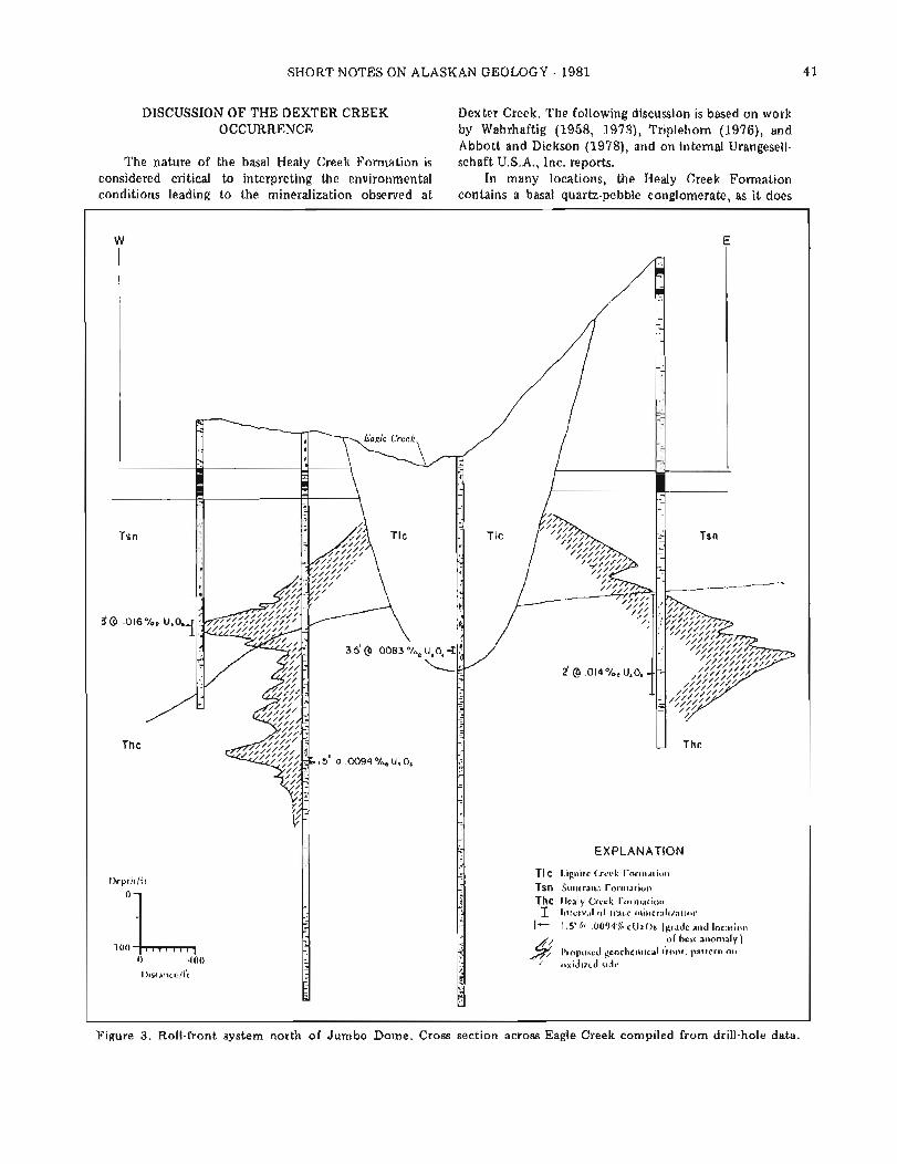
SHORT NOTES ON ALASKAN GEOLOGY - 1 9 8 1 4 1
DISCUSSION OF THE DEXTER CREEK Dexter Creek. The following discussion is based on work OCCURRENCE by Wahrhaftig (1958, 1973), Triplehorn (1976), and
Abbott and Dickson (1978), and on internal Urangesell- The nature of the basal Healy Creek Formation is schaft U.S.A., Inc. reports.
considered critical to interpreting the environmental In many locations, the Healy Creek Formation conditions leading to the niineralization observed a t contains a basal quartz-pebble conglomerate, as it does
Figure 3. Roll-front system north of Jumbo Dome. Cross section across Eagle Creek compiled from drill-hole data.
W E
l I
I)cptll/ft
L 100 0 400
L)~stat~ce/ft -
-
EXPLANATION
TIC 1.ig11itr Crcck r o r ~ ~ ~ r t i o ~ ~
Tsn ! i u ~ ~ t r a ~ ~ : i i-orll~atioll
Thc Ilealy Cleck I'OI ~ll:ltiorl
1 ~l l tcrv:~I o f ~I:ICC ~ ~ ~ i r ~ c r : ~ l i r : ~ t i o ~ ~
1- 1.5' .0094'% l 'U308 [grade ;llld IOCafiOll
o f best a ~ ~ o r t l a l ~ 1 I'roposcd g c o c l ~ e r ~ ~ ~ c a l i r o l ~ t , pattcrrl or1 oxidized sidc

4 2 GEOLOGIC REPORT 73
a t Dexter Creek. The characteristics of this conglomerate are indicative of a high-energy fluvial environment. The conglomerate contains a sand and clay matrix but is generally not well consolidated. The quartz pebbles are poorly rounded and are apparently derived from quartz veins in nearby metavolcanics. In areas where the con- glomerate is absent, a deeply weathered erosional surface on the underlying schists is preserved and the schist is altered to quartz and kaolinite, which suggests intense chemical weathering in a warm, humid climate. Frag- ments of this weathered material, which represent initial fluvial deposition of reworked, weathered schist with locally derived sand and pebbles, are present in the basal Healy Creek conglomerate. The recognition of a warm, humid paleoclimate is critical t o the epigenetic ura- nium potential of interior Alaska.
Volcanic ash in the basal Healy Creek Formation is indicated by relict textures observed in thin section and by a doubly terminated beta-quartz crystal identified in drill cuttings from Healy Creek strata in the California Creek basin, 1 0 miles north of Jumbo Dome. Volcanic ash has been noted elsewhere in the coal-bearing group (Triplehorn, 1976).
At the Dexter Creek location, several feet of weath- ered schist are preserved below a thin basal con- glomerate. The exact position of the contact is difficult t o define. In the drill holes, the mineralization is only 2 t o 3 f t above the weathered schist, which is about 3.5 f t thick. In outcrop, the interval between the mineralized zone and the underlying schist is between 1 0 and 3 0 ft.
On the basis of these observations, the mineralized horizon was probably deposited in a relatively high- energy fluvial system and later isolated, producing the stagnant conditions indicated by the abundant organic carbon and ,manganese. After burial, uranium was leached from the ash and precipitated by the reducing action of the organic material. Evidently, enough ash was present to account for the amount of uranium encountered. The conditions that restricted the mineral- ization to a single horizon within a sequence of ap- parently similar beds are unknown. At Dexter Creek, seepage into fractures in the underlying schist produced minor anomalies similar t o the mineralization previously noted in the Lignite Creek drainage.
Additional drilling indicated a limited extent o f the Dexter Creek occurrence. T o determine the potential for further 'Dexter Creek type' mineralization, a series of radon surveys was conducted across Healy Creek For- mation sediments. Although several anomalies were located, they were usually quite small or were easily explained by proximity t o high-uranium-background metavolcanics. A single drill hole in the largest anomaly failed t o intersect any mineralization. The 'Dexter Creek type' mineralization seems limited to very small, low- grade occurrences.
CONCLUSION
The recognition of epigenetic-uranium mineral- ization in Tertiary sediments of interior Alaska is signifi- cant for paleoenvironmental and exploration considera- tions. The uranium occurrences were located by in- tensive geochemical prospecting, airborne radiometry, widespread radon surveys, and over 21,000 f t of drilling a t 43 locations. Although the potential for undiscovered, economic uranium.deposits in this area is now judged t o be quite low, future workers should benefit from a re- view of geologic processes that occurred within the Tertiary coal-bearing group in the Nenana Coal Field.
ACKNOWLEDGMENTS
I thank the management of Urangesellschaft U.S.A., Inc. for their support and permission to release pro- prietary information. I also thank Dr. Volkmar Janicke, William Schneider, Jane Dickson, and Barbara Magg for their assistance and criticism. I am especially indebted t o Dr. Earl Abbott for his contribution of ideas, criticism, and encouragement. I also wish t o acknowledge Gilbert R. Eakins and Daniel B. Hawkins for their reviews of the manuscript and helpful suggestions.
REFERENCES
Abbott, E.W., and Dickson, R.K., 1978, Sedimentary uranium in Alaska: Northwest Mining Association Convention, 84th, Spokane, Washington, November 30-December 2 , 1 9 7 8 , unpublished.
Dickinson, K.A., 1978, Uraninite in sideritic nodules from Tertiary continental sedimentary rocks in the Healy Creek basin area, central Alaska: U.S. Geolog- ical Survey Circular 804-B, p. B98-B99.
Levinson, A.A., 1980, Introduction t o exploration geochemistry (2d ed.): Wilmette, Illinois, Applied Publishing Ltd., 924 p.
Triplehorn, D.M., 1976, Clay mineralogy and petrology of the coal-bearing group near Healy, Alaska: Alaska Geological and Geophysical Surveys Geologic Report 52, 1 4 p.
Wahrhaftig, Clyde, 1958, Lithology and conditions of deposition of the formations of the coal-bearing group in the Nenana Coal Field, Alaska: unpub- lished, 9 3 p.
, 1970a, Geologic map of the Healy D-3 Quadrangle, Alaska: U.S. Geological Survey Quadrangle Map GQ-805, scale 1:63,360.
, 1970b, Geologic map of the Healy D-4 Quadrangle, Alaska: U.S. Geological Survey Quadrangle Map GQ-806, scale 1:63,360.
, 1973, Coal reserves of the Healy Creek and Lignite Creek coal basins, Nenana Coal Field, Alaska: U.S. Geological Survey Open-file Report 568, 6 p., 28 pi.
Wahrhaftig, Clyde, Wolfe, J.A., Leopold, E.B., and Lanphere, M.A., 1969, The coal-bearing group in the Nenana Coal Field, Alaska: U.S. Geological Survey Bulletin 1274-D, 30 p.

RECONNAISSANCE OF RARE-METAL OCCURRENCES ASSOCIATED WITH THE OLD CROW BATHOLITII, EASTERN ALASKA-NORTHWESTERN CANADA
By James C. Barker1
INTRODUCTION AGE CORRELATION AND STRUCTURAL SETTING
Evidence suggests that the emplacement, tectonics, and chemical composition of the Old Crow batholith, located in eastern Alaska and western Yukon Territory, Canada, are favorable for the occurrence of tin, tung- sten, uranium, tantalum, niobium, and other rare metals. This evidence was reinforced by findings of uranium, tin, rare-earth oxides, and base metals during the 1976-80 field seasons.
REGIONAL GEOLOGY
The Old Crow batholith (fig. 1 ) forms the structural core of the Porcupine Plateau, a discrete physiographic province characterized by an unglaciated, gently rolling terrain (Wahrhaftig, 1965). Vegetation is nearly con- tinuous and there is very little outcrop.
Reconnaissance geolofic mapping of the Old Crow area, adapted from Brosge (1969), is shown in figure 2. The Old Crow batholith intrudes and is bordered on the north by quartz-mica schist to semischist, phyllite, quartzite, and a greenstone substrata, all of Pre- cambrian(?) t o early Paleozoic age. These metamorphic rocks may correlate with the Neruokpuk Formation described by Sable (1977).
The batholith is bounded on the south by a succes- sion of prominent allochthonous blocks. Lower Paleo- zoic (possibly Precambrian) quartzite and phyllite units are overthrusted by Mississippian to Jurassic sandstone and chert strata. Thrusting is apparently from the southwest, possibly associated with past movement along the very poorly defined Kaltag-Porcupine fault system. Within the batholith, extensive fracturing, faulting, and offsets, frequently with an east-to-north- orientation, are readily apparent.
West of the Old Crow batholith is a structural basin that contains an ophiolite sequence of uncertain age. Sheet dikes of diorite and gabbro are common in the cherts, argillites, basalts, and greenstones of the se- quence.
Potassium-argon mica ages from intrusive rocks of the Old Crow batholith range from 220 t o 345 5 1 0 m.y. (table 1).
The oldest date correlates closely with those re- cently reported for Brooks Range (Dillon and others, 1979) and northern Yukon granites (Baadsgaard and others, 1961). The younger dates probably indicate recrystallization ages within the batholith, and suggest repeated postintrusive tectonic and thermal-alteration events. The initial intrusion would then correlate with the regional Late Devoniiln orogeny of northern Alaska (Sable, 1977). A major regional unconformity between Upper Devonian or Mississippian and older rocks, referred t o by Baadsgaard and others (1961) and other more recent investigators, lends credence t o this hypo- thesis. Thus, the age of the Old Crow batholith is infer- red to be Carboniferous or Devonian. Sable (1977)
'US. Bureau of Mines, Fairbanks. Alaska 99701. Figure 1. Location of study area, Porcupine Plateau, Alaska.
44 GEOLOGIC REPORT 73

SHORT NOTES ON ALASKAN GEOLOGY - 1981
*- Y c al al
N 2 % D a- z &
S o u t h e l e v a t i o n a N o r t h e l e v a t i o n
2000'
1000 '
Sea Level
Geology compiled by J. C. Barker, assisted by M. W. Payne (1977) and K. H. Clautice (1977-78)
Vertical exaggeration approximately 5x; horizontal exaggeration 2x
EXPLANATLON
Contact, dashed where approximate
N Gradational contact
---- High-angle fault, dashed where approximate
UAA Thrust fault, dashed where approximate . Quartz vein
6 Ba Mineral occurrence; number indicates discussion in text
[ Quaternary or Tertiary basalt
1 Tertiary coal-bearing sandstone, mudstone, and conglo~nerate
Jurassic or Permian Christian Complex ophiolite
i-1 Jurassic or Mississippian chert and sandstone . ...... _ _ . . . . . . . . . . . . , . . . . . . , . . .
1 PZq 1 Paleozoic quartzite
Rhyolite-porphyry sills
j Carboniferous Old Crow Batholith; includes locally porphyritic biotite granite and quartz monzonite (gr), typically altered 1eu:ocratic zone (Igr), and dark-colored, granitized intrusive border zonr (cgr)
Paleozoic o r Precambian schist and quartzite
Paleozoic or Precambrian metasediments
4 6 GEOLOGIC REPORT 73
suggests the potassium-argon age dates indicate an intermediate thermal event 220 t o 280 m.y. ago.
Uplift of the batholith during Tertiary time resulted in deposition of terrigenous sediments in adjacent areas. Evidence of more recent uplift exists along the Porcu- pine River, where canyon walls 500 f t high are capped by Quaternary basalt and thick Quaternary(?) gravel terraces. Also, well-preserved and obviously recently abandoned channels of the Porcupine River are present a t elevations up to 300 f t above the existent water course. This recent uplift and subsequent erosion and reworking of the granitic material have played an im- portant role in the formation of heavy-mineral placer deposits in the area.
INTRUSIVE GEOLOGY
The Old Crow batholith is a broadly domed, multi- phased, partially contaminated granitic body of apparent crustal derivation. Locally, it is a porphyritic quartz
sharp northern contact between the batholith and the quartz-mica schist and quartzite is locally hornfelsed and is garnet and biotite rich.
CHEMICAL CHARACTERISTICS O F THE OLD CROW BATHOLITH
Detailed 44-element chemical analyses of 1 3 3 intrusive and contact rocks were performed by neutron activation and X-ray fluorescence in a joint U.S. Bureau of Mines (USBM) - Department of Energy (DOE) an- alytical program (Stablein, 1980). The data were ex- amined for trace-element levels that would indicate rare-metal potential. The extensive weathering and varied alteration precluded comparison with typical 'tin granites.' Background tin values of 1 5 t o 4 0 ppm are common in samples with intense chloritic, silicic, and sericitic alteration. Rhyolite sills south of the intrusion did reflect generally higher background amounts of niobium, tantalum, uranium, beryllium, and several
Table 1. Potassium-argon age determinations o f intrusive rocks, Old Crow Batholith
Sample Mineral location Age ( m y . ) Reference
Biotite Alaska 314 t 9 ~ r o s ~ d , 1969 Muscovite Alaska 335 + 1 0 Brosgd, 1969 Biotite Alaska 299 2 9 Brosgd, 1969 Biotite Alaska 295 5 9 Brosgd, 1969 Biotite Canada 220 Baadsgaard and others, 1 9 6 1 Biotite Canada 265 + 1 2 Wanless and others, 1967 Biotite Canada 345 + 1 0 Bassett and Stout , 1967
monzonite t o biotite granite containing large microcline phenocrysts. By modal mineralogy it is an equigranular biotite granite. Biotite is partially altered t o chlorite. Hematization and intense alteration of chlorite, silica, and sericite are present.
In cross section, the southern and western parts of the batholith show a gently dipping, granitized contact with the host rock. Aeromagnetic evidence indicates that the intrusion extends a t a shallow depth as far south as the Porcupine River (Brosge' and others, 1970). Con- taminated black sericite granite with traces of carbona- ceous material is typical of the contact region. Abundant replacement tourmaline as rosettes and as a black groundmass suggests boron enrichment in the upper cupola zone. Underlying this contaminated zone is a leucocratic intermediate zone of coarse- t o fine-grained quartz monzonite, aplite dikes, and two-mica granite. Within this variable zone, and in conjunction with postintrusive structural features, is much of the miner- alization and alteration. The inner core consists of a coarse equigranular t o porphyritic quartz monzonite.
Rhyolite-porphyry sills intrude phyllite, argillite, calc-argillite, siltstone, and quartzite on the southern and western edges of the contaminated border zone. The
other elements; the arithmetic means in 11 rhyolite samples are 70.1, 6.2, 13.7, and 16.4 ppm, respectively. Tin values in the 11 samples ranged from 0 to 6 9 8 ppm; up t o 0.08 percent tin was found in nearby copper-lead- zinc tactites.
The extremely weathered and eroded granitic surface of the batholith overlies a frozen, impervious layer of clay and clay-rich silts. The frozen material and lack of subsurface water hindered stream-sediment sampling; thus the results are not correlative with mineralization. Tin values of u p to 300 ppm in stream- sediment samples are probably due to 'captured' grains of cassiterite. Uranium values were relatively low even in an area of known secondary uranium mineralization.
Sampling of soils brought t o the surface in frost boils was generally the most effective geochemical method for isolating mineralized localities. Pathfinder elements such as lead, arsenic, and yttrium appear t o correlate with the occurrences of uranium.
Whole-rock and chemical analyses were also per- formed on splits of 1 4 typical granite samples from the Old Crow batholith collected by the U.S. Geological Survey in 1967 (table 2). The SiO2 content averages 76.2 percent and indicates late-stage differentiation.
SHORT NOTES ON ALASKAN GEOLOGY - 1981
Normative quartz averages 42 percent, which equals or exceeds the range indicative of tin granites (Hesp and Rigby, 1974). The tin content of 14 other typical granite samples (table 2) was close t o the detection limit of 1 0 ppm, although 31 altered or sheared, unmineral- ized granite samples averaged 24 ppm tin.
MINERALIZATION
Mineralization in the Old Crow batholith might be compared with the European Hercynian Orogeny granites that contain uranium- and tin-bearing veins. Within the intermediate or leucocratic zone of the batholith, uranium, tin, and associated base-metals occur with quartz veins, cataclastic zones, and greisen-like alteration.
An excellent example of this type of mineralization occurs along a prominent linear feature that intersects a small, south-flowing tributary of the Rapid River (loc. 1 , fig. 2). Feldspars of a cataclastic granite are extensively altered to sericite and muscovite, and finely dis- seminated secondary hematite is present. The weathered, vuggy surface samples that were examined contained about 0.01 percent uranium and several hundred ppm each of tin, lead, and zinc. Artesian springs in the area periodically emanate anomalous amounts of radon, depending on the season and recent precipitation level.
At the second location (loc. 2, fig. 2), secondary uranium minerals and anomalous concentrations of tin, copper, lead, zinc, and arsenic occur in disseminated pods and as vein and fracture coatings in a leached and sheared quartz vein that extends along a ridge top for about 1,000 ft. X-ray-diffraction analysis revealed the presence of xenotime, uranophane, arsenuranylite, and metatorbernite. Abundant disseminated hematite lends a reddish cast t o some quartz veins.
Reconnaissance ground radiometrics and soil sampling identified a number of other localities with possible uranium enrichment. The prospects define an approximate east-west trend that extends to the Cana- dian border. Location 3 (fig. 2) encompasses a 600- by 2,400-ft tundra-covered area.
Thorium is not present in appreciable amounts at these sites, although heavy-mineral concentrates from streams in the area frequently contain 40 to 65 percent monazite. The source of the rare-earth minerals has not been identified. There is an apparent potential for extensive placer deposits of cassiterite, monazite, and, resistant uranium-bearing minerals such as allanite and xenotime, with minor amounts of an unidentified niobium-tantalum-bearing mineral and scheelite. Bulk samples of loose, poorly sorted surface gravels from nearly all active streams that drain the batholith indicate the consistent presence of these minerals in aggregate amounts of about 1 1blyd3. Concentrates contained 2 to 25 percent tin, with up to 1 0 percent thorium and about 0.5 percent tungsten. There has been no drilling or
Many drainage systems in the area have a low gradient and contain enough water to support a large- scale dredge or dragline operation. Recent uplift re- moved and disintegrated la]-ge quantities of granitic rock, causing the heavy minerals to be reworked and con- centrated into placer depc sits. Broad valleys containing alluvial-gravel deposits are particularly noticeable along the Rapid River and thc main channels of Strangle Woman Creek.
Near the southern margin of the batholith, rhyolite- porphyry sills intrude calc-argillites and hornfels phyl- lites, and small skarn deposits (loc. 4 , fig. 2) are present along the contacts. Thes? deposits contain up to 1 0 percent copper in the forrn of chalcopyrite and bornite, with associated galena, sl~halerite, and magnetite. Tin (up to 0.08 percent), berjllium, and silver are present in anomalous amounts. Heavy manganese-oxide coatings are common. Although the mineralization could be measured only as thin lenses up to 50 f t in strike length, the area is an obvious geochemical target.
East of this locality. a silicified fracture zone in black phyllite and si1t;tone contains disseminated chalcopyrite and galena (loc. 5, fig. 2). Mineralization, which rarely exceeds several percent of the combined metal content of copper and lead, occurs as rubble along the fracture zone for about 1,200 ft. Zinc is present in negligible amounts. App.uently the mineralization a t these two localities don ; the southern margin of the batholith is intimately related to the rhyolite-porphyry sills and not to the granites. The relationship between the sills and the batholith is unclear.
Several veins of mi~ssive barite occur along the northern contact of the batholith (loc. 6 , fig. 2). No sulfides are associated wit I these veins.
Information for this report was primarily derived from reconnaissance-level mineral investigations con- ducted by the U.S. Bureau of Mines in east-central Alaska from 1976 to 19g0. More detailed information is available in USBM Open-file Report 27-81, 'Mineral investigations in the Porcupine River drainage.' The author acknowledges the previous geologic mapping and whole-rock-sample splits provided by W.P. Brosgd of the U.S. Geological Survey :.nd the petrographic assistance of T.C. Mowatt (USBM). N.K. Stablein (1980) of Bendix Engineers provided analytical support through a DOE contract with the Los Alamos Scientific Laboratory, New Mexico.
REFERISNCES CITED
Baadsgaard, H., Folinsbee, R.E., and Lipson, J., 1961, Caledonian or Acad an granites of northern Yukon Territory, in Raasch, G.C)., ed., Geology of the Arctic: Toronto l'niversity Press, p. 458-465.
trenching.
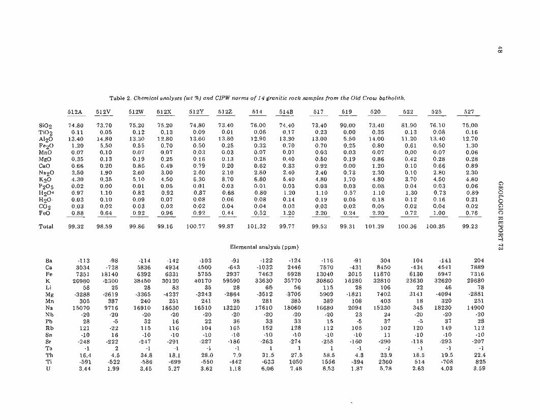
Table 2. Chemical analyses ( w t 5%) and CIPW norms o f 14 granitic rock samples from the Old Crow batholith.
SiO2 T i 0 2 A120 F e z 0 MnO MgO CaO Na2O K 2 0 P205 H2O+ H20- c o 2 F eO
Total
Elemental analysis (ppm)


A RECENT EARTHQUAKE ON THE DENALI FAULT IN THE SOUTHEAST ALASKA RANGE
By Larry Gedneyl and Steven Estesl
INTRODUCTION
Alaska's Denali fault is probably the best docu- mented fault system in the state. Unquestionably, it has the most striking topographic expression of all the large-scale, strike-slip faults in Alaska; its deeply incised fault-line valley can be traced for several hundred kilometers through the Alaska Range and southeast into the Shackwak Valley and Yukon Territory, Canada (Forbes and others, 1976).
On April 2, 1981, an earthquake of magnitude 4.4 occurred in the southeastern Alaska Range on a segment of the fault previously thought to be seismically dormant. Because the earthquake epicenter was located about 50 km from the Alaska Highway---and the pro- posed natural-gas-pipeline route---modification of cur- rent estimates of seismic risk in adjacent areas may be necessary.
SEISMICITY OF THE SOUTHEAST DENALI FAULT DURING HISTORIC TIME
According to Tobin and Sykes (1966), only one earthquake---on August 31, 1958---was recorded in the southeast segment of the Denali fault from 1954 to 1964. A very low level of seismicity has been recorded in the area since 1966, when the University of Alaska Geophysical Institute established the central Alaska seismic network.
In 1967, Boucher and Fitch (1969) conducted a microearthquake survey along portions of the Denali fault from Haines t o Mt. McKinley. Although they noted microearthquakes at all sites, the tremors were generally too small t o be detected or located by a regional net- work. Because these authors did not occupy a site within 100 km of the April 2 earthquake, there are no data on background seismic activity for the area.
LATERAL OFFSET ON THE DENALI FAULT
Lateral offset during historic time, whether earth- quake-generated or related to fault creep, is not satis- factorily documented along the Denali fault (Page and Lahr, 1971; Page, 1972; Savage, 1975). Estimates of Holocene right-lateral offset range from 50 m near the Delta River (Stout and others, 1973) to 350 m west of
l~eophys ica l Institute, University of Alaska. Fairbanks, 99701.
Mentasta Pass (Richter and Matson, 1971), and estimates of Pleistocene offset by these authors range from 3 to 6.5 km. On the basis of petrological, structural, and geochronologic evidence, Forbes and others (1974) proposed a 400-km offset along the northeast-central Denali fault since Early Cretaceous time. Richter and Matson (1971) specifically stated that the epicentral area between the Nabesna and Chisana Rivers was one of the few localities in the eastern Alaska Range where they did not observe evidence for Holocene lateral movement on the Denali fault.
THE APRIL 2,1981 EARTHQUAKE
On April 2,1981, at 0615 local time, an earthquake of magnitude 4.4 occurred on the southeast Denali fault. The earthquake was felt a t Northway, about 6 5 km from the epicenter, where one resident reported his wood stove rocked back and forth. According to the local store owner, the earthquake was felt by several other persons in the area.
The earthquake was recorded at 83 different seis- mographic stations in Alaska and Canada. Because scaling difficulties increase with distance, only the 4 3 stations within a 450-km radius of the epicenter were used to locate the focus a t lat. 62.430 N., long. 142.040 W., and 8 km below ground level (fig. 1). The computer solution indicates an uncertainty in epicentral location of 6 km and a possible depth range of from 0 to 20 km.
A 'fault-plane' or 'focal-mechanism' solution of the earthquake is shown in figure 2. Although readings were obtained from more than 80 stations, only 37 had clear enough 'first arrivals' to include in the solution. The stereographic plot indicates the positions where primary longitudinal waves from the earthquake begin their travel t o each of the observing stations; refraction of the ray along its path is considered. Most earthquakes generate a quadrant distribution of initial P-wave com- pressions and dilatations, and these initial impulses are believed to maintain their original sense of motion along their entire travel path (Byerly and Stauder, 1957). For an ideal strike-slip earthquake, the region surrounding the epicenter is divided into four quadrants separated by vertical planes that intersect at right angles and pass through the focus. Stations in adjacent quadrants alternately receive initial compressional or dilatational impulses, depending on whether they are located ahead of or behind the throw of the fault.

52 GEOLOGIC REPORT 73

SHORT NOTES ON ALASKAN GEOLOGY - 1981
North o0
0
1 80° COMPRESSION O DILATATION
2 APRIL 1981 ORIGIN TIME= 16:10:43.7
LATITUDE= 62.43"N DEPTH = 7.9 KM LONGITUDE. 142.04O W ML= 4.4
Figure 2. Fault-plane solution of April 2, 1981 earthquake on the Denali fault, Alaska. Cross-hatched areas mark error limits of nodal planes. Their apparent awkward configuration results from use of the Wulff equal-angle net. Incon- sistent observations at stations SSN and KLU may be due t o a combination of incorrect station calibration, scaling error, and other factors.

54 GEOLOGIC REPORT 73
Without more sophisticated diagnosis, it is not possible t o distinguish which plane represents the fault and which plane represents the perpendicular 'auxiliary plane.' Generally, an identification can be made by reference to the tectonic setting.
Possible solutions in figure 2 are a) left-lateral off- set on a fault trending northeast-southwest, or b) right- lateral offset on a fault trending northwest-southeast. The latter solution is probably applicable because the trend of the northwest-southeast-striking plane (N. 600 W. + 50) parallels the Denali fault (Richter and Matson, 1971).
DISCUSSION
Richter and Matson (1971) note a marked decrease in Holocene fault activity southeast of Mentasta Pass and recognize the Totschunda fault as a possible new trans- current fault connecting major strike-slip systems (in- cluding the Fairweather fault) in southeast Alaska. In fact, the Totschunda fault may be shunting lateral motion that was previously absorbed by the Denali fault near Mentasta Pass. The April 2 earthquake, however, seems to provide evidence that not all horizontal dis- placement is occurring along the Totschunda fault, and that this segment of the Denali fault may be more active than previously recognized.
ACKNOWLEDGMENTS
We express our appreciation to D.B. Stone, J.F. Meyer, R.D. Reger, and R.B. Forbes for their critical reviews and valuable suggestions and to D.L. Marshall for assistance in analyzing and processing the data. We also wish to thank the U.S. Geological Survey at Menlo Park, the Alaska Tsunami Warning Center a t Palmer, and the Earth Physics Branch of the Department of Energy, Mines, and Resources in Ottawa, Canada, for providing their station data. This research was supported by State of Alaska funds appropriated to the Geophysical Insti- tute, University of Alaska, Fairbanks.
REFERENCES CITED
Boucher, Gary, and Fitch, T.J., 1969, Microearthquake seismicity of the Denali fault: Journal of Geo- physical Research, v. 74, p. 6638-6648.
Byerly, Perry, and Stauder, W.V., 1957, Motion at the source of an earthquake: Publications of the Domi- nion Observatory, v. 20, no. 2 , p. 255-261.
Forbes, R.B., Pulpan, Hans, and Gedney, Larry, 1976, Seismic risk and the Denali fault: Prepared for Gulf Interstate Engineering Company, Geophysical In- stitute, University of Alaska, 52 p.
Forbes, R.B., Smith, T.E., and Turner, D.L., 1974, A solution to the Denali fault offset problem: Alaska Division of Geological and Geophysical Surveys Annual Report, 1973, p. 25-27.
Page, R.A., and Lahr, John, 1971, Measurements of fault slip on the Denali, Fairweather, and Castle Moun- tain faults, Alaska: Journal of Geophysical Re- search, v. 76, p. 8534-8543.
Page, R.A., 1972, Crustal deformation on the Denali fault in Alaska 1942-1970: Journal of Geophysical Research, v. 77, p. 1528-1533.
Richter, D.H., and Matson, N.A., 1971, Quaternary faulting in the eastern Alaska Range: Geological Society of America Bulletin, v. 82, p. 1529-1540.
Savage, J.C., 1975, Further analysis of the geodetic strain measurements on the Denali fault in Alaska: Journal of Geophysical Research, v. 80, p. 3786- 3790.
Stout. J.H., Brody, J.B., Weber, F.R., and Page, R.A., 1973, Evidence for Quaternary movement on the McKinley strand of the Denali fault in the Delta River area, Alaska: Geological Society of America Bulletin, v. 84, p. 939-947.
Tobin, D.G., and Sykes, L.R., 1966, Relationship of hypocenter of earthquakes t o the geology of Alas- ka: Journal of Geophysical Research, v. 71, p. 1659- 1667.
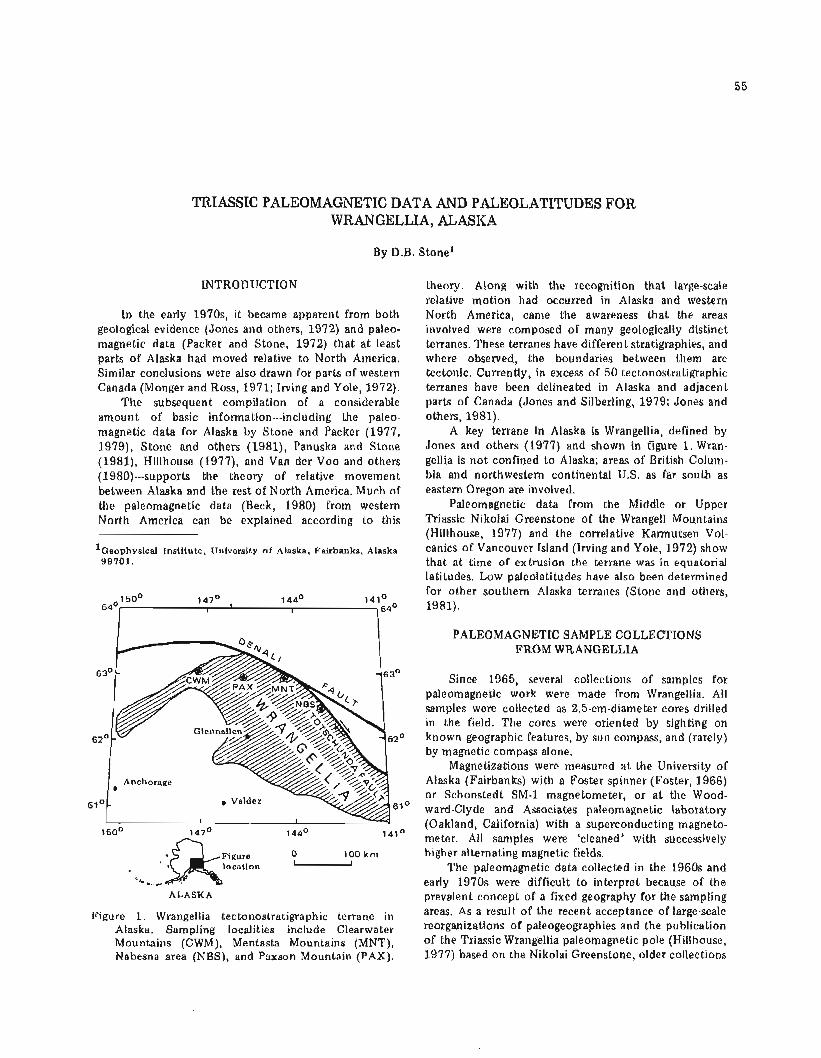
TRIASSIC PALEOMAGNETIC DATA AND PALEOLATITUDES FOR WRANGELLIA, ALASKA
By D.B. Stone1
INTRODUCTION
In the early 1970s, it became apparent from both geological evidence (Jones and others, 1972) and paleo- magnetic data (Packer and Stone, 1972) that a t least parts of Alaska had moved relative t o North America. Similar conclusions were also drawn for parts of western Canada (Monger and Ross, 1971; Irving and Yole, 1972).
The subsequent compilation of a considerable amount of basic information---including the paleo- magnetic data for Alaska by Stone and Packer (1977, 1979), Stone and others (1981), Panuska and Stone (1981), Hillhouse (1977), and Van der Voo and others (1980)---supports the theory of relative movement between Alaska and the rest of North America. Much of the paleomagnetic data (Beck, 1980) from western North America can be explained according to this
l~eophysica.1 Institute, University o f Alaska. Fairbanks. Alaska 99701.
Figure 0 100 krn Mlocation .'- ......
ALASKA
Figure 1. Wrangellia tectonostratigraphic terrane in Alaska. Sampling localities include Clearwater Mountains (CWM), Mentasta Mountains (MNT), Nabesna area (NBS), and Paxson Mountain (PAX).
theory. Along with the recognition that large-scale relative motion had occurred in Alaska and western North America, came the awareness that the areas involved were composed of many geologically distinct terranes. These terranes have different stratigraphies, and where observed, the boundaries between them are tectonic. Currently, in excess of 50 tectonostratigraphic terranes have been delineated in Alaska and adjacent parts of Canada (Jones and Silberling, 1979; Jones and others, 1981).
A key terrane in Alaska is Wrangellia, defined by Jones and others (1977) and shown in figure 1. Wran- gellia is not confined t o Alaska; areas of British Colum- bia and northwestern continental U.S. as far south as eastern Oregon are involved.
Paleomagnetic data from the Middle or Upper Triassic Nikolai Greenstone of the Wrangell Mountains (Hillhouse, 1977) and the correlative Karmutsen Vol- c a n i c ~ of Vancouver Island (Irving and Yole, 1972) show that a t time of extrusion the terrane was in equatorial latitudes. Low paleolatitudes have also been determined for other southern Alaska terranes (Stone and others, 1981).
PALEOMAGNETIC SAMPLE COLLECTIONS FROM WRANGELLIA
Since 1965, several collections of samples for paleomagnetic work were made from Wrangellia. All samples were collected as 2.5-cm-diameter cores drilled in the field. The cores were oriented by sighting on known geographic features, by sun compass, and (rarely) by magnetic compass alone.
Magnetizations were measured a t the University of Alaska (Fairbanks) with a Foster spinner (Foster, 1966) o r Schonstedt SM-1 magnetometer, o r a t the Wood- ward-Clyde and Associates paleomagnetic laboratory (Oakland, California) with a superconducting magneto- meter. All samples were 'cleaned' with successively higher alternating magnetic fields.
The paleomagnetic data collected in the 1960s and early 1970s were difficult to interpret because of the prevalent concept of a fixed geography for the sampling areas. As a result of the recent acceptance of large-scale reorganizations of paleogeographies and the publication of the Triassic Wrangellia paleomagnetic pole (Hillhouse, 1977) based on the Nikolai Greenstone, older collections
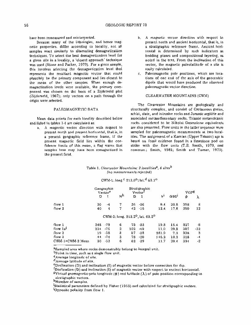
GEOLOGIC REPORT 73
have been remeasured and reinterpreted. Because many of the lithologies, and hence mag-
netic properties, differ according to locality, not all samples react similarly t o alternating demagnetization techniques. T o select the best demagnetization level for a given site in a locality, a 'closest approach' technique was used (Stone and Packer, 1979). For a given sample, this involves selecting the demagnetization level that represents the resultant magnetic vector that could plausibly be the primary component and lies closest to the mean of the other samples. When enough de- magnetization levels were available, the primary com- ponent was chosen on the basis of a Zijderveld plot (Zijderveld, 1967); only vectors on a path through the origin were selected.
PALEOMAGNETIC DATA
Mean data points for each locality described below and listed in tables 1-4 are calculated as:
a. A magnetic vector direction with respect to present north and present horizontal, that is, in a present geographic reference frame. If the present magnetic field lies within the con- fidence limits of this mean, a flag warns that samples here may have been remagnetized in the present field.
flow 1 flow 2
b. A magnetic vector direction with respect t o present north and ancient horizontal, that is, in a stratigraphic reference frame. Ancient hori- zontal is determined by such indicators as bedding planes and compositional layering, as noted in the text. From the inclination of this vector, the magnetic paleolatitude of a site is easily calculated.
c. Paleomagnetic pole positions, which are loca- tions of one end of the axis of the geocentric dipole that would have produced the observed paleomagnetic vector direction.
CLEARWATER MOUNTAINS (CWM)
The Clearwater Mountains are geologically and structurally complex, and consist of Cretaceous gneiss, schist, slate, and intrusive rocks and Jurassic argillite and associated metasedimentary rocks. Triassic metavolcanic rocks considered t o be Nikolai Greenstone equivalents are also preserved. Flow units in the latter sequence were sampled for paleomagnetic measurements at two local- ities. The assignment of a Karnian (Upper Triassic) age is based on fossil evidence found in a limestone pod on strike with the flow units (T.E. Smith, 1979, oral commun.; Smith, 1981; Smith and Turner, 1973).
Table 1. Clearwater Mountains; 2 localitiesa, 6 sitesb (no measurements rejected)
Geographic Stratigra hic Vectore Vector 'i' V G P ~ D I Nh D I ki a 9 5 i @
CWM-2; long. 213.2', lat. 63.2O
flow 1 ' 348 -79 6 7 3 -33 19.8 15.4 327 -8 flow l a ] 234 -76 2 1 0 2 -49 11.0 29.8 307 -32 flow 2 1 9 -58 3 57 -23 281.9 7.3 338 3 flow 3 44 -74 3 7 8 -20 145.2 10.3 318 -4 CWM-l+CWM-2 Mean 30 -53 6 6 2 -29 11.7 20.4 334 -2
asampled area where rocks demonstrably belong t o integral unit. b ~ o i n t in time, such as a single flow unit. CAverage longitude of site. d ~ v e r a g e latitude of site. eDeclination (D) and inclination (I) of magnetic vector before correction for dip. f ~ e c l i n a t i o n (D) and inclination (I) of magnetic vector with respect to ancient horizontal. gVirtual geomagnetic-pole longitude ( 9 ) and latitude (A) of pole position corresponding t o
stratigraphic vectors. h ~ u r n b e r of samples. !Statistical parameters defined by Fisher (1953) and calculated for stratigraphic vectors. JOpposite polarity from flow 1 .

SHORT NOTES ON ALASKAN GEOLOGY - 1981
Table 2. Mentasta Mountains; 3 localities, unknown number of sites over 200 m of vertical section
MNT-1, -2, -3; long. 216.1°, lat. 62.96O
Geographic Stratigraphic Vector Vector VGP D I N D I k Cr95 8 h
MNT-1 (6m section) 73 -51 6 97 -56 80.8 7.5 318 -35 MNT-2a(10m section) A 81 27 8 77 -12 28.6 10.5 320 0
B 103 -35 12 145 -52 8.5 15.8 269 -53 MNT-3 (40m section) 95 60 16 76 20 21.0 8.2 314 16 Mean (excluding B data) 82 1 5 3 8 1 -16 4.4 38 318 -3
8 5 34 30 79 -3 6.0 11.7 317 3
aMNT-12 is divided into two groups; MNT-2B is not included in final mean because it is more discordant than rejection criteria allow.
Table 3. Nabesna; 2 localities, + 1 I sites
NBS-2; Lost Creek; long. 216.g0, lat. 62.6O; 8 m stratigraphic section; number of flows not determined
Geographic Stratigraphic Vector Vector VGP D I N D I k a 9 5 A
Combined data 139 5 11 152 40 50.2 6.5 243 -2
NBS-5, -6, -7 Skookum Creek; long. 217O, lat. 62.4O
NBS-5 flow 5.1 flow 5.2 flow 5.3 flow 5.4a flow 5.4b flow 5.5a flow 5.5b flow 5.6 flow 5.7
NBS-6 flow 6.1 flow 6.2
NBS-7 flow 7.1
Meana normal (N-up VGP) 10 21 5 9 -11 9.1 26.8 25 20
Mean reversed (S-up VGP) 183 -18 4 180 -19 5.6 42.7 217 -38
Mean normal + reversed 7 -5 9 5 2 7.3 20.5 30 28
aFinal means exclude flows 5-1 and 7-1, which are considered to represent present field, and flow 6.1, which is more discordant than rejection criteria allow. Statistics on final means are for VGP's; remaining statistics are for stratigraphic vectors.
GEOLOGIC REPORT 7 3
Table 4. Paxson; 1 locality, 7 sites
PAX; long. 214.3O, lat. 63.1°
Geographic Stratigraphic Vector Vector VGP D I N D I k a 9 5 A
flow 1 106 1 2 3 103 4 flow 2 102 14 2 103 -7 flow 3a 289 75 4 354 69 flow 4 110 1 2 111 -5 flow 5 101 6 3 101 -3 flow 6 22 76 3 31 56 flow 7 78 45 2 69 29 Mean of flows 1,2,4,5 105 6 4 104 -2
aFlows 3,6,7 were rejected; 3 and 6 are close t o present field; flow 7 is more discordant than rejection criteria allow.
PALEOMAGNETIC DATA (CWM:l, -2)
These samples were collected and measured in 1972; new measurements and new statistics were calculated in 1979.
Although the length of time represented by this collection from six flow units is difficult to reliably estimate, the stratigraphic thickness (50 m) may indicate a sufficiently long time span to average secular variation of the field. The small number of sites for the two localities is probably the major contributor t o the spread of the magnetic directions. What was originally called flow 1 from locality CWM-2 was subdivided into flows 1 and l a on the basis of a polarity change. This subdivision does no t conflict with the geology, because flow bound- aries are no t clearly defined in the exposures. The localities are about 6 km apart and approximately on strike with one another. The magnetic stability of the flows is indicated by the fact that both polarities of field are present (CWM-2, flow la).
T o obtain the mean-flow direction for the final analysis, the closest approach of all samples was used. The flowmeans and overall mean are shown in figure 2 and the basic information is shown in table 1.
MENTASTA MOUNTAINS (MNT)
The Mentasta Mountains are divided into two geologic provinces by the Denali fault. North of the fault the section consists of regionally metamorphosed sedimentary rocks, which generally dip steeply t o the southwest. South of the fault the rocks are very weakly metamorphosed and dip a t moderate angles to the northeast. Paleomagnetic samples were taken from Triassic amygdaloidal basalts mapped as Nikolai Green- stone (Richter, 1967, 1976) that crop ou t south of the fault and uncomformably overlie the Permian Manko- men Formation, which consists of argillite, shale, lime- stone, and chert. The Nikolai Greenstone is conformably
overlain by massive limestone, limy siltstone, and sandstone of probable Late Triassic age (Richter, 1976).
The Triassic basalts form a ridge approximately 8 km west-northwest of Mentasta Village; exposure is intermittent. Paleomagnetic samples were collected from three localities along the ridge. No interbedded sedi- ments were observed, and the attitude of the flow units was determined from vesicular layering. The internal consistency of the attitude of this banding and its similarity t o that of the adjacent sediments are strong indicators that it represents ancient horizontal.
PALEOMAGNETIC DATA (MNT)
Original paleomagnetic measurements on these samples are reported by Packer (1972). Additional demagnetization levels were applied t o the original data, and figure 2 shows the means of all data as selected by the closest-approach methods. At locality MNT-2, two discrete sets of vector direction were subdivided into sample sets A and B (top and bot tom of section, re- spectively). However, several samples indicated both directions during demagnetization, and we conclude that two components of magnetization were present. Because the B directions were discordant with respect t o other localities, they are not included in the final mean. Locality means are shown because it was not possible to accurately identify the number of flow units at each locality. The mean of both localities and samples and the sample mean used in the final compilation are shown in table 2.
NABESNA (NBS)
Samples were obtained from three localities in the Triassic Nikolai Greenstone (Richter, 1976). In the Nabesna area, the folmation underlies Triassic lime- stone containing subordinate interbeds of banded sandstone and siltstone, calcareous siltstone, silty
SHORT NOTES ON ALASKAN GEOLOGY - 1981
a. Clearwater Mountains b. Mentasta Mountains
N
c. Nabesna area d. Paxson Mountam
Figure 2. Paleomagnetic data for Clearwater Mountains, Mentasta Mountains, Nabesna area, and Paxson Mountain.

GEOLOGIC REPORT 73
limestone, and calcareous mudstone. Locality NBS-2 is located about 9 km north of the
Nabesna road on the east side of Lost Creek; the rocks dip about 450 NW (Packer 1972). Localities NBS-4, -5, and -7 are located on Skookum Creek near Devil's Mountain Lodge. The attitudes of sites NBS-5 and -7 were determined from a distinctive purple-red-shale unit interbedded with the flows.
Mesozoic in age, and probably equivalent t o the Nikolai Greenstone. Numerous dacite porphyry dikes of Tertiary age cu t the basalt.
Three to six samples were collected from each of a series of seven flows exposed near the Denali Highway. Accurate attitudes were difficult t o obtain, but the flows were estimated t o dip a t about 200 NE (380 east of north), which compares favorably with attitudes mapped by Stout (1976).
PALEOMAGNETIC DATA (NBS) PALEOMAGNETIC DATA (PAX)
Initial results for NBS-2 and -4 are reported in Packer (1972) and Chantry-Price (1967), respectively; results from NBS-5 and -7 are not previously reported. The NBS-2 and -4 data have been reevaluated. The re- sults and mean of the NBS-2 reevaluation and the data from NBS-5, -6, and -7 are shown in table 3 and in figure 2. The latter data show both normal and reversed polarities that are antiparallel within their confidence limits. Data selection was based on the closest-approach technique. In addition, flows 5.1 and 7.1 were rejected because they are magnetized along the present field, and flow 6.1 was rejected because it was beyond the dis- cordance cutoff of 400.
PAXSON MOUNTAIN (PAX)
Paxson Mountain, located near the junction of the Richardson and Denali Highways, was mapped by S tou t (1976) as a gray-green t o olive metabasalt he calls the Paxson Mountain Basalt. He considers it lowermost
Figure 3. Polar stereographic projection of mean virtual geomagnetic poles and mean pole (WRG) of Hill- house ,(1977). Circles of confidence are at 9 5 per- cent level (Fisher, 1953).
The original measurements on these cores are re- ported by Chantry-Price (1967). Additional demagnet- ization levels have been measured and the statistics recalculated using the closest-approach method.
Of the seven flows, four show consistency and shallow inclination for the magnetic vector. Three steeply magnetized flows displayed erratic behavior during demagnetization, and two of these approximate the present field direction. Therefore, the data from these three flows were not included in the final mean. Figure 2d shows the individual combined flow mean; locality information is listed in table 4.
RECONSTRUCTION
Paleogeographic reconstructions are traditionally formed by the superposition of paleomagnetic poles of the same age. According t o the dipole hypothesis, only one pair of poles can exist a t any given time. Thus, if the poles from different areas are separated, relative motion between them is implied. Superposition of the poles yields the relative paleolatitude of two areas, but does no t constrain their relative longitudes with respect t o the paleomagnetic pole.
In addition t o the problems of constraining pale- olongitude, there is also an inherent uncertainty in the location of the paleopole position for any given locality. First, any tilting of the ancient horizontal is assumed t o have occurred as a simple rotation---which can be simi- larly corrected---about the present strike of bedding. Thus, any tectonic activity that produces more than one axis of folding o r tilting can introduce serious errors in the paleomagnetic pole positions. Second, local rotation of tectonic blocks about a vertical axis---as might be expected for blocks caught between two transcurrent faults---will be seen as a dispersion of the paleomagnetic poles.
In contrast, paleomagnetic-latitude data are derived solely from the inclination of the magnetic vector relative t o ancient horizontal.
The mean paleomagnetic pole positions for the sampled localities and the approximate location of the area sampled [with an enclosing circle of equal colati- tude (800)l are shown in figure 3.
If the paleolatitude derived from the paleomagnetic data is the same for each site, then the paleomagnetic

SHORT NOTES ON ALASKAN GEOLOGY - 1981
Table 5. Summary of paleomagnetic vectors and equivalent pole positions.
Stratigraphic Vector VGP Paleo-A
N D I k a 9 5 h P. A
CWM-1,-2 6 62 -29 11.7 20.4 334 -2 4:15:30 MNT-1,-2,-3 30 79 -3 6.0 11.7 317, 3 -8:-1:4 NBS-2 11 152 40 50.2 6.5 243 -2 18:23:28 NBS-5,-6 9 5 2 7.3 20.5 30 28 -1O: l : l l PAX 4 104 -2 155 7.4 292 -8 4:1:2 W R G ~ 50 255 21 18.3 4.8 146 2 8:11:14 Mean VGP excluding
NBS-2,-5,-6 4 259 3 19.0 21.6 137 -2 -13:-2:lO
aData from Hillhouse (1977).
poles will fall on the same small circle of colatitude. The scatter of poles around that circle of equal colatitude can be caused by tectonic rotation or by multiple tilting of the locality.
In figure 3, marked longitudinal scatter of paleo- magnetic poles is coupled with a consistent grouping. Both the widespread geographic distribution of sampling localities and the fact that the two most discordant localities at Nabesna (NBS) are very close to the Totschunda fault system (with its additional po- tential for local rotation), indicate that the grouping represents a mean pole. The mean and circles of con- fidence of the pole have been calculated with Fisher statistics (Fisher, 1953), although strictly speaking they apply only to circular distributions of vector directions. Thus, the quoted error limits should be used only as guides and not as an accurate assessment of the con- fidence limits.
Because the polarity of the sampled field is un- known, the paleomagnetic pole positions for the new data in tables 1-4 are listed in the central Atlan'tic Ocean (dong . 3200), but the overall mean pole listed in table 5 is in the southwest Pacific Ocean (wlong. 1400). On the basis of evidence from Permian-age rocks (Panuska and Stone, 1981), the southwest Pacific Ocean is the pre- ferred location for the ancient pole position equivalent to today's magnetic north pole.
CONCLUSIONS
The mean poles in table 5 indicate that Wrangellia must have been very close to, and probably north of the equator when the basalt that forms the Nikolai Green- stone was erupted. These data substantiate the con- clusion of Hillhouse (1977) and fit well with data from older (Panuska and Stone, 1981) and younger (Stone and others, 1981) rocks. The combined data suggest southward latitudinal motion between Permo-Triassic and Middle Jurassic time, followed by a systematic northward motion of Wrangellia from about Middle Jurassic time to the present.
This systematic south-then-north motion, if real, is
critical to the interpretation of the geology of Alaska, because it indicates that the present geography of Alaska is geologically very young.
ACKNOWLEDGMENTS
I would like to acknowledge the help of Bruce Panuska in the preparation of the data and manuscript, D.R. Packer and Woodward-Clyde and Associates for as- sistance with data collection and processing, and the University of Newcastle upon Tyne for initiating the project. I appreciate the critical reviews of Sherman Gromme' (U.S. Geological Survey) and John Decker (DGGS). Most financial support came from National Science Foundation grants GA-1216 and EAR-00817.
REFERENCES CITED
Beck, M.E., 1980, Paleomagnetic record of plate margin tectonic processes along the western edge of North America: Journal of Geophysical Research, v. 85, p. 7115-7131.
Chantry-Price, R.E., 1967, A paleomagnetic investiga- tion of some post-Carboniferous rocks from Alaska: University of Newcastle upon Tyne, unpublished M.S. thesis, 130 p.
Fisher, R.A., 1953, Dispersion on a sphere: London, Proceedings of the Royal Society, series A217, p. 295-305.
Foster, J.H., 1966, A paleomagnetic spinner magneto- meter using a fluxgate gradiometer: Earth and Planetary Science Letters, v. 1 , p. 463-466.
Hillhouse, J.W., 1977, Paleomagnetism of the Triassic Nikolai Greenstone, McCarthy Quadrangle, Alaska: Canadian Journal of Earth Science, v. 14 , p. 2578- 2592.
Irving, E., and Yole, R.W., 1972, Paleomagnetism and the kinematic history of the mafic and ultramafic rocks in fold mountain belts: Ottawa, Department of Energy, Mines, and Resources, v. 42, p. 87-95.
Jones, D.L., Irwin, W.P., and Ovenshine, A.T., 1972, Southern Alaska - a displaced continental fragment: U.S. Geological Survey Professional Paper 750A, p. B213-B219.
GEOLOGIC REPORT 73
Jones, D.L., and Silberling, N.J., 1979, Mesozoic strati- graphy - the key to tectonic analysis of southern and central Alaska: U.S. Geological Survey Open- file Report 79-1 200, 37 p.
Jones, D.L., Silberling, N.J., Berg, H.C., Plafker, George, 1981, Map showing tectonostratigraphic terranes of Alaska, columnar sections, and summary descrip- tion of terranes: U.S. Geological Survey Open-file Report 81-792.
Jones, D.L., Silberling, N.J., and Hillhouse, J.W., 1977, Wrangellia - a displaced terrane in northwestern North America: Canadian Journal of Earth Science, v. 14, p. 2565-2577.
Monger, J.W.H., and Ross, C.A., 1971, Distribution of fusilinaceans in the western Canadian Cordillera: Canadian Journal of Earth Sciences, v. 8 , p. 259- 278.
Packer, D.R., 1972, Paleomagnetism of the Mesozoic in Alaska: Fairbanks, University of Alaska, unpub- lished Ph. D. dissertation, 160 p.
Packer, D.R., and Stone, D.B., 1972, An Alaskan Juras- sic paleomagnetic pole and the Alaskan orocline: Nature, v. 237, p. 25-26.
Panuska, B.C., and Stone, D.B., 1981, Late Paleozoic paleomagnetic data for Wrangellia; resolution of the polarity ambiquity: Nature, v. 293, p. 561-563.
Richter, D.H., 1967, Geology of the Upper Slana - Mentasta Pass area, south-central Alaska: Alaska Division of Mines and Minerals Geologic Report 30, 25 p.
Richter, D.H., 1976, Geologic map of the Nabesna Quadrangle, Alaska: U.S. Geological Survey Mis-
cellaneous Geologic Investigations Map 1-932. Smith, T.E., 1981, Geologic map of the western Clear-
water Mountains, central Alaska: Alaska Division of Geological and Geophysical Surveys Geologic Report 60, 72 p.
Smith, T.E., and Turner, D.L., 1973, Geochronology of the McLaren metamorphic belt, south-central Alaska: A progress report: Isochron/West, no. 7, p. 21-25.
Stone, D.B., and Packer, D.R., 1977, Tectonic implica- tions of Alaska Peninsula paleomagnetic data: Tectonophysics, v. 37, p. 183-201.
, 1979, Paleomagnetic data from the Alaska Peninsula: Geological Society of America Bulletin, v. 90, p. 545-560.
Stone, D.B., Panuska, B.C., Packer, D.R., 1981, Paleo- latitudes versus time for southern Alaska: Journal of Geophysical Research [in press].
Stout, J.H., 1976, Geology of the Eureka Creek area, east-central Alaska Range: Alaska Division of Geological and Geophysical Surveys Report 46, 32 p.
Van der Voo, R., Jones, D.L., Grommd, C.S., Eberlein, G.D., Churkin, Michael, 1980, Paleozoic paleo- magnetism and northward drift of the Alexander terrane, southeastern Alaska: Journal of Geo- physical Research, v. 85, p. 5281-5296.
Zijderveld, J.D.A., 1967, A.C. demagnetization of rocks; analysis of results, in Collinson, D.W., Creer, K.M., Runcorn, S.K., eds., Methods in paleomagnetism: Amsterdam, Elsevier, p. 254-286.