shire of moorabool social … of moorabool - social infrastructure plan – final draft report for...
TRANSCRIPT

Shire of Moorabool - Social Infrastructure Plan – Final Draft Report for Public Exhibition, November 2006. 1
SHIRE OF MOORABOOL SOCIAL INFRASTRUCTURE PLAN
FINAL DRAFT REPORT
November 2006
Prepared by:
Bernadette George Social Planner
BG Urban Solutions 196 Canterbury Rd St Kilda 3182
Ph 9534 1683; Mobile 0408 053 408; Email: [email protected]

Shire of Moorabool - Social Infrastructure Plan – Final Draft Report for Public Exhibition, November 2006. 2
TABLE OF CONTENTS Executive Summary pa 5 1. Introduction pa 19
1.1 Purpose of the Project 1.2 Methodology 1.3 Defining Social Infrastructure 1.4 Defining Need
2. Review of Background Reports pa 24 2.1 Population Trends 2.2 Shire of Moorabool Council Plan 2005-2009 2.3 Moorabool Shire Council Social Development Plan (2002) 2.4 Moorabool Health and Well-being Strategy 2003-2006 2.5 Disability Access and Inclusion Policy (2002) 2.6 Moorabool Municipal Strategic Statement Review (2004) 2.7 Ballan Urban Growth Strategy (2004) 2.8 Bacchus Marsh Residential Growth Strategy (2004) 2.9 Bacchus Marsh Accessibility, Traffic Management and Parking Study (2003) 2.10 Bacchus Marsh District Trails Master Plan (2005)
3. Consultation pa 43 3.1 Consultation Process 3.2 Community Feedback
3.2.1 Internal – Council Officer Feedback 3.2.2 External – Service Provider Feedback
3.3 Determining “Adequate” Level of Social Infrastructure Provision
4. Community Facilities and Services Audit pa 50 4.1 Existing Community Facilities: General pa 51
4.1.1 Djerriwarrh Health Services Primary Care 4.1.2 General Welfare and Community Services 4.1.3 Caravan Parks and the Demand for Affordable Housing 4.1.4 Bus and Train Services
4.2 Existing Community Facilities: Darley pa 55 4.2.1 Darley
4.2.1.1 Darley Park 4.2.1.2 Darley Neighbourhood House 4.2.1.3 Darley Plaza and Medical Centre 4.2.1.4 Visiting Services 4.2.1.5 Darley Park Campus – Bacchus Marsh Secondary College 4.2.1.6 Pentland Primary School 4.2.1.7 Pentland Child Care and Pre-school 4.2.1.8 ABC Learning (Grey St) Child Care 4.2.1.9 Darley Montessori Pre-school 4.2.1.10 Telford Park Flora Reserve 4.2.1.11 Darley Primary School 4.2.1.12 Lerderderg Children’s Centre
4.3 Existing Community Facilities: Bacchus Marsh pa 64 4.3.1 Bacchus Marsh
4.3.1.1 St Bernard’s Primary School 4.3.1.2 Bacchus Marsh Primary School

Shire of Moorabool - Social Infrastructure Plan – Final Draft Report for Public Exhibition, November 2006. 3
4.3.1.3 Gell St Maternal and Child Health 4.3.1.4 Bacchus Marsh Child Care and Pre-school 4.3.1.5 Young Street Pre-school (and Play Groups) 4.3.1.6 Quamby Community and Senior Citizen’s Centre (Bennett St) 4.3.1.7 Rotary Park 4.3.1.8 Bacchus Marsh Library 4.3.1.9 Moorabool Shire Aged Services 4.3.1.10 Moorabool Shire Community Services Offices 4.3.1.11 Tourist Information Centre 4.3.1.12 Bacchus Marsh Community Radio 4.3.1.13 The Laurels – Bacchus Marsh Adult Education Centre 4.3.1.14 Pepper Tree Park 4.3.1.15 Maddingley Campus – Bacchus Marsh Secondary College 4.3.1.16 Bacchus Marsh Leisure Centre / YMCA 4.3.1.17 Eco Link Science and Technology Innovations Centre 4.3.1.18 Maddingley Park 4.3.1.19 Bacchus Marsh Walking Trails 4.3.1.20 Bacchus Marsh Railway Station 4.3.1.21 Bacchus Marsh Grammar School
4.4 Existing Community Facilities: Ballan pa 91 4.4.1 Ballan
4.4.1.1 Mechanics Institute Hall 4.4.1.2 Ballan Senior Citizens’ Centre 4.4.1.3 Ballan Indoor Leisure Centre 4.4.1.4 Ballan Primary School 4.4.1.5 St Bridgid’s Catholic Primary School \ 4.4.1.6 Ballan Pre-school, Maternal and Child Health and Child Care 4.4.1.7 Ballan District Health and Care: Hospital and Aged Care Hostel 4.4.1.8 Ballan Railway Station 4.4.1.9 Ballan Recreation Reserve 4.4.1.10 Ballan Court House 4.4.1.11 Caledonia Park 4.4.1.12 Caledonia Reserve Caravan Park
5. Recommended Social Infrastructure Provision pa 102
5.1 General Recommendations pa 103 5.1.1 Djerriwarrh Health Services 5.1.2 Affordable Housing and Support Services 5.1.3 Visitor Accommodation and Tourism Promotion 5.1.4 Bus Services 5.1.5 Pedestrian and Cycle Networks 5.1.6 Strategic Planning – Municipal Strategic Statement 5.1.7 Social Impact Assessment
5.2 Darley pa 113 5.2.1 Lerderderg Multi-purpose Community Centre 5.2.2 Pedestrian and Cycle Network Upgrade 5.2.3 Local Shopping and Community Health Services 5.2.4 Darley Community Centre 5.2.5 Darley Neighbourhood House
5.3 Bacchus Marsh pa 119 5.3.1 Quamby Community Centre

Shire of Moorabool - Social Infrastructure Plan – Final Draft Report for Public Exhibition, November 2006. 4
5.3.2 Improving Housing choice for Older Adults and People with Disabilities 5.3.3 Rotary Park 5.3.4 Pedestrian and Cycle Network Upgrade 5.3.5 Library / youth Resource / Civic Centre 5.3.6 Maddingley Park and surrounds 5.3.7 Maddingley Primary School 5.3.8 Maddingley Community Centre 5.3.9 Bacchus Marsh Train Station 5.3.10 Bacchus Marsh Pool
5.4 Ballan pa 133 5.4.1 Ballan Maternal and Child Health and Pre-school Centre 5.4.2 Caledonian Park 5.4.3 Ballan Recreation Reserve 5.4.4 Ballan Train Station 5.4.5 Ballan Hospital and Aged Care Hostel 5.4.6 Ballan Court House
6. Implementation pa 137 7. References pa 140
Maps: Map 1: Existing Trails Network – Bacchus Marsh District Map 2: Recommended Trails Network – Bacchus Marsh District Map 3: Existing Bus Routes - Darely – Bacchus Marsh Map 4: Social Infrastructure Existing Conditions – Darley Map 5: Social Infrastructure Existing Conditions – Bacchus Marsh Map 6: Social Infrastructure Existing Conditions – Ballan Map 7: Social Infrastructure Recommended Future Provision – Darley Map 8: Social Infrastructure Recommended Future Provision – Bacchus Marsh Map 9: Social Infrastructure Recommended Future Provision – Ballan Tables: Table 1 A: Social Infrastructure Audit Summary - Darley Table 1 B: Social Infrastructure Audit Summary - Bacchus Marsh Table 1 C: Social Infrastructure Audit Summary - Ballan Appendices: Appendix 1: Service Provider Consultation Listing Appendix 2: Aged Care Residential Services – Future Needs (Internal Council Assessment July 2005) Appendix 3: Moorabool Shire Council – Integrated Development Assessment Group Terms of Reference Appendix 4: Birth Notification Data: Shire of Moorabool 1994/5 – 2004/5

Shire of Moorabool - Social Infrastructure Plan – Final Draft Report for Public Exhibition, November 2006. 5

Shire of Moorabool - Social Infrastructure Plan – Final Draft Report for Public Exhibition, November 2006. 6
Executive Summary 1. Introduction: Why Council needs a SIP Moorabool Shire Council needs a Social Infrastructure Plan as an essential tool to manage recent and expected future residential development within the municipality. Much of that growth has been, and will continue to be concentrated around the Bacchus Marsh-Darley area and the township of Ballan. For this reason the Social Infrastructure Plan focuses its attention on these settlements only, although it should be acknowledged that improved social infrastructure provision in these areas will still have flow on benefits for residents of more isolated areas within the Shire As an important preparatory step towards planning for any one new development area within the Moorabool Shire, there is a need to gain an understanding of existing and likely future community infrastructure provision requirements and usage patterns. To develop this understanding it is necessary to undertake two key tasks:
o Review population and urban growth patterns for the Shire, in this case focussing on the two major settlements of Bacchus Marsh and Ballan;
o Review existing community facilities and services with regard to condition of buildings, relevance and accessibility to services, and to consider optimum strategic directions for future provision.
The outcome of these two tasks is the preparation of a Social Infrastructure Plan (SIP) for the townships of Bacchus Marsh and Ballan. This document deals with the range of social infrastructure typically required to support an existing or future community and is intended to document:
o What community facilities and services are expected to be needed, o When they will be required, o Where they should be located and o How they might be funded.
From a clear illustration of future community infrastructure requirements tied to specific growth areas and projected population growth, presented by a Social Infrastructure Plan, it is then possible to identify likely cost implications and appropriate apportionment of costs and how these might be met, including via what proportion is considered reasonable and equitable to be covered by development contributions. This Social Infrastructure Plan for the communities of Bacchus Marsh and Ballan can be regarded, therefore, as one of three key strategic planning documents for Council, together with the Capital Improvement Plan (CIP) and Municipal Strategic Statement (MSS), as it continues to aim to meet the needs of the communities for which it is responsible. Three stages were identified for the successful development of the Social Infrastructure Plan. These are: A Community Facilities Audit – covering building condition, operational cost and usage trends; A Social Infrastructure Plan – covering present and anticipated future needs over the coming 15-20 years, pending confirmation of future population projections / potential residential land yield;

Shire of Moorabool - Social Infrastructure Plan – Final Draft Report for Public Exhibition, November 2006. 7
An Implementation Strategy – consisting of a table listing recommended facilities and services, potential funding sources and recommended timeframe for delivery. To complete these three stages this Study involved the following tasks:
A review of population and demographic profile and trends and Council’s urban growth strategies; A review of Council strategic documents and policies; A review of documented community feedback obtained through the conduct of other related strategic
studies, the conduct of consultative forums and presentation of a draft for comments Identification, inspection and analysis of existing social infrastructure against established criteria An assessment of future needs based on the demographic profile and projections.
From this research and consultation the extensive list of specific recommendations were formed. 2. Policy Basis for Recommendations Council’s stated vision for the municipality is that: “By 2009 Moorabool Shire will be characterised by viable communities and towns forming an integrated Shire with a strong identity” (Moorabool Shire Council Plan 2005-2009; pa 5) As shown in italics in the above quote, for the purpose of determining necessary future social infrastructure requirements, the key words are considered to be: “viable communities”, “integrated” and with a “strong identity”. What constitutes a viable community has not been defined, however this issue has been briefly discussed in section 1.4, in relation to strategic planning objectives versus the flaws in a “population ratio” approach to social infrastructure provision standards, and is considered in more detail in section 5 below. With specific regard to services and infrastructure the Council Plan also states that these will be supported by:
o Long term financial forecasting o Sound financial and resource management; o Performance based land use planning; and o Key external partnerships.
The above four criteria have been borne in mind in the course of undertaking a review, or audit, of existing community facilities. The findings of this review are presented in section 4 of this report and followed by recommendations for future provision in section 5. Also of relevance to the preparation of a Social Infrastructure Plan is Council’s fifth objective, which deals with Services and Infrastructure and which states that Council aims:
o “To provide sustainable quality community services to enhance the wellbeing of the community;
o To undertake maintenance and development works on Shire infrastructure to meet current and future needs and

Shire of Moorabool - Social Infrastructure Plan – Final Draft Report for Public Exhibition, November 2006. 8
o Recognise and plan to meet needs of target groups (these being) youth, aged, family and children, and disabled.” (ibid; pa 10-11)
It is considered the above elements of the adopted Council Plan provide a very clear direction for determining need and optimum strategic direction for the planned provision of social infrastructure for the Shire’s two main townships of Ballan and Bacchus Marsh. The recommendations were also informed by a number of other adopted Council policies and recent strategic reviews. These included:
o Moorabool Health and Well-being Strategy 2003-2006 o Disability Access and Inclusion Policy (2002) o Moorabool Municipal Strategic Statement Review (2004) o Ballan Urban Growth Strategy (2004) o Bacchus Marsh Residential Growth Strategy (2004) o Bacchus Marsh Accessibility, Traffic Management and Parking Study (2003) o Bacchus Marsh District Trails Master Plan (2005) o Municipal Early Years Plan o Library Review
As a result, the SIP recommendations are all consistent with the directions or recommendations of these other Council documents. It should also be noted that the assessment of existing infrastructure, along with the recommendations for upgrades and new infrastructure, is based on an assessment of geographical and cultural profiles of the study areas rather than straight population ratios. This approach is supported by the author’s experience in need assessment, particularly in Frankston, Camberwell and Laverton, which highlighted the methodological and political inadequacies (and inaccuracies) of using population ratios as the sole or primary determinant of infrastructure need. Rather, the approach taken in the preparation of the Moorabool SIP has been to respond to extensive previous local community consultation (particularly feedback obtained through the process of preparing a Social Development Plan (2002) and Health and Well-being Strategy (2003) for the Shire over recent years) and guidance provided by a range of relevant Local and State planning policy and guidelines relating to the need to provide infrastructure within walkable communities as a means of optimising community well-being and consolidating infrastructure through improving accessibility and maximising the utilisation of community facilities. (e.g. Safer Design Guidelines (Dept Justice & DSE, 2004) and SEPA Guidelines for Local Government (Heart Foundation, 1999))

Shire of Moorabool - Social Infrastructure Plan – Final Draft Report for Public Exhibition, November 2006. 9
3. The Recommendations In terms of application, the Social Infrastructure Plan should be used by council and developers in particular, as a reference document in the course of preparing structure plans and detailed development proposals. For example, some 18 hectares of land identified in the Growing Moorabool Strategy (refer SGS Economics and Planning 2006; Section 3.3.2) as appropriate for Activity Centre planning relates to much of the area covered by recommendations for Maddingley and Bacchus Marsh contained in this report (refer section 5.3.1-5.3.9). The final implementation strategy for the SIP should therefore be used to inform the project brief for a Structure Plan for this area. Note also in relation to some of the recommendations below, the intention is to enable Council to become more strategic in responding to community needs by preventing problems occurring in the first place (e.g. pedestrian safety, older adult social isolation or unfunded infrastructure requirements) or reducing the inefficiency of recurrent costs to Council by facilitating improved and pre-emptive capital investment (e.g. aiming to reduce the recurrent costs to Council of supervised crossings while not compromising the level of safety for school children) General
Note that, wherever applicable, the recommendations herein should be referred to Council for consideration as part of the 20-year Capital Improvement Program, 20-year Financial Plan and Development Contributions Plans (to be prepared). Further, it is intended the Social Infrastructure Plan is used as a reference document in the course of any future preparation of structure plans within the Shire.
5.1.1 Djerriwarrh Health Services and Ballan District Health & Care
o The recommended comprehensive upgrade and expansion of the Quamby Community Centre (refer 5.3.1 below) include provision of consulting rooms and meeting space for a range of “visitor providers” of specialist health services;
o The Shire of Moorabool continue to work collaboratively via the Heath and Well-Being
Advisory Committee towards effective advocacy for improved recognition by funding agencies of the population growth and consequent growing demand for health services in both the Bacchus Marsh – Darely and Ballan and District areas;
o The recommended comprehensive upgrade and expansion to the Ballan District Health & Care
Primary Care Centre located in Cowie St Ballan include provisions for additional consulting rooms and meeting space for a range of visiting specialist health services;
o The Shire of Moorabool recognise the importance of improved public transport, pedestrian and
cycle supporting infrastructure as key determinants of accessibility to health as well as other services and facilities and prioritise improvements in this area of infrastructure provision accordingly.

Shire of Moorabool - Social Infrastructure Plan – Final Draft Report for Public Exhibition, November 2006. 10
5.1.2 Affordable Housing and Support Services o Aim to work with neighbouring municipalities and the State Government to promote a more
co-ordinated and preventative approach to dealing with issues of unemployment, family breakdown, mental illness and homelessness.
o In partnership with other key agencies, via establishing a co-ordinating local service provider
reference group, seek to advocate for and facilitate improved supply of affordable housing and support services and their provision in locations that are easily accessed by those without a car.
5.1.3 Visitor Accommodation and Tourism Promotion
o Council work co-operatively with existing owners of local hotels, motel and caravan parks and potential investors and nearby tourism promotion agencies in Melbourne, Daylesford and Ballarat, to improve the quality and quantity of visitor accommodation;
o Council more actively promote the townships of Bacchus Marsh and Ballan as attractive short
term holiday destinations;
o Council actively encourage new visitor accommodation to be developed within 400m of the Ballan and Bacchus Marsh train stations.
5.1.4 Accessible Housing
o Council amend its Municipal Strategic Statement (MSS) to include a clause to cover (and promote) the provision of affordable and accessible housing, including provision of a map highlighting key sites and precincts (such as those that offer 400m attractive pedestrian routes to shops and public transport);
o Council initiate / convene regular Economic Development Forums, to better promote the social
need and housing market opportunities for developers prepared to refine housing product to meet the needs of significant and potentially growing sectors of the community, including older adults and people with disabilities;
o Council use its Capital Works Improvement Programme, together with funding support from
Dept of Infrastructure and Dept of Sustainability and Environment, to progressively upgrade identified key pedestrian networks (consistent with the Bacchus Marsh District Trails Master Plan) as a “supporting infrastructure” initiative by Council to attract new housing investment in designated precincts as per amended MSS.
5.1.5 Bus services
o Council, in partnership with local bus operators and with support from the Dept of Infrastructure (Office of Public Transport), review existing bus routes to confirm optimum access and efficiency outcomes for both existing and potential patrons seven days a week;
o Council, in partnership with Dept of Infrastructure and local in-kind community feedback and
support, identify key locations which require improved supporting infrastructure such as safer bus stop locations, provision of shelters and timetable information.

Shire of Moorabool - Social Infrastructure Plan – Final Draft Report for Public Exhibition, November 2006. 11
5.1.6 Pedestrian and bicycle networks
o Council prepare an integrated Pedestrian and Cycle Plan for Darely – Bacchus Marsh and for Ballan, to rectify existing danger points while more proactively encouraging a healthy and more sustainable transport pattern for existing and future residents. Such a plan would need to identify:
o The most efficient, safe and attractive routes to key destinations; o Adequate pavement widths to accommodate people in wheelchairs, pedestrians and
cyclists; o Appropriate pavement material to ensure durability, while also safeguarding the comfort
of longer distance walkers, the needs of people in wheelchairs and with other forms of disability (e.g. loose gravel can be dangerous for frail aged) and satisfying understandable parental concern regarding the safety of their children.
o Council introduce an overlay control into the Moorabool Shire Planning Scheme to ensure
existing and future commercial, institutional and private residences contribute positively to the ambience and sense of public safety of the urban context along the routes that form part of the Bacchus Marsh – Darley and Ballan integrated pedestrian and cycle plan/s by prohibiting extensive sections of blank or high walls and other threats to natural surveillance and consequent public safety.
o To reduce recurrent costs, Council work with VicRoads and other State Government agencies toward reducing the number of supervised crossings by replacing those locations with the highest vehicle volumes and speeds with upgraded pedestrian operated light facilities. Having regard to existing conditions and community feedback, these “priority” locations currently include:
o Grant St, near Station St - Griffith St and opposite the swimming pool-Pepper Tree Park entrance;
o Gisborne Rd, near St Bernard’s Primary School and Lerderderg St; o Albert St, opposite Lerderderg Children’s Centre o Nelson St, opposite Darley Primary School
Note that future / strategic locations for pedestrian operated lights, to more actively encourage pedestrian activity via improving perceptions of safety, include:
o Grey St, between Dundas St and Darley Plaza; o Halletts Way, near Durham St and opposite Pentland Primary School-Darley Campus of Bacchus Marsh Secondary College;
Note also that in some high traffic volume locations, including Gisborne Rd near St Bernard’s Primary School, it is likely that continued supervision of the pedestrian crossing will still be required during school start and finish times.

Shire of Moorabool - Social Infrastructure Plan – Final Draft Report for Public Exhibition, November 2006. 12
5.1.7 Strategic Planning: Municipal Strategic Statement & Development Contributions
o In line with best practice adopted by a number of other municipalities, including the City of Whittlesea and the City of Hobsons Bay, Council insert additional clauses the Moorabool Shire Council’s MSS to cover the following matters:
o Disabled access o Walkable neighbourhoods / Sustainable transport Patterns o Housing Diversity - Ageing in Place and Visitor Accommodation o Tourism o Health Promotion o Social Infrastructure Funding and Provision.
o Council, in accordance with relevant provisions of the Planning and Environment Act 1987 (as
amended) prepare Development Contributions Plan for each precinct of the existing and future urban areas of the three planning precincts (Darley, Bacchus Marsh and Ballan) for new infrastructure required as a result of all new development, including any redevelopment of existing urban areas.
5.1.8 Social Impact Assessment
o Council, prepare and adopt a Social Impact Assessment policy and requirement for all new significant development.
Darley 5.2.1 Lederderg Multi-purpose Community Centre
o Redevelopment of existing children’s centre site to create a permanent and fully integrated early childhood centre, integrated with adjacent Darely primary school.
5.2.2 Pedestrian and cycling network upgrade, Darley
o Establish a priority pedestrian and cycle (off-road or otherwise grade separated) network that links key local community, educational, recreational facilities and connection to Bacchus Marsh. Key routes will include:
o Gisborne Rd o Grey St o Halletts Way o Albert St, o Nelson St o Fitzroy St o Approach streets to Darley Neighbourhood House
5.2.3 Local Shopping and Community Health services
o Council work in partnership with local traders and owners of Darley Plaza to promote and foster better social, economic and environmental outcomes for both Darley and Bacchus Marsh by improving local provision of community and shopping facilities in Darley as a local complement to the greater range of retail services that should continue to be concentrated in Bacchus Marsh.

Shire of Moorabool - Social Infrastructure Plan – Final Draft Report for Public Exhibition, November 2006. 13
5.2.4 Telford Park
o Council commence longer-term planning, by formal designation of a site within Telford Park, for the provision of an additional multi-purpose community centre to provide a range of community services within a walkable distance of most homes within this northern precinct within Darley. This facility could be designed to be integrated with the adjacent Darely Campus of the Bacchus Marsh Secondary College and could conceivably have a commercial component such as café and convenience store.
5.2.5 Darley Neighbourhood House
o Noting that planning for an upgrade has been approved, improve pedestrian access (e.g. minimum 2.5m footpath network) to the facility from some key destination / linkage points including:
o Darley primary school and Lerderderg children’s centre, via Nelson Street and improved pedestrian crossing facilities where Nelson St intersects with Grey St;
o Jonathon Drive (where the neighbourhood house is located) and adjacent un-landscaped reserve;
o Grey St and Morrison Drive;
o Create a direct pedestrian link from the south side of Grey St, perhaps at the southern end of McMahon Court, through to the northern side of Jonathon Drive, subject to the views and co-operation of existing residents and relevant landowners.
Bacchus Marsh 5.3.1 Quamby Community Centre (Redevelopment into an integrated community and health care centre)
o Demolish the existing centre and redevelop the site to accommodate a new multi-purpose health and community centre with the following components:
o Entrance foyer that doubles as exhibition space (estimate 60sqm) o Senior Citizens wing that includes all the existing distinct elements but with central
access, to allow for broader community use, of the kitchen (refer below) and dance hall; o Full commercial kitchen o Medium-sized dance hall to accommodate 100 people – table setting and dance floor o Maternal and Child Health centre (replacing temporary facility in Gell St) and including
consulting room and adjacent small community meeting room (refer below) o Relocated Pre-school (from Young Street) o Occasional Child Care o Integrated health care centre (including consulting rooms for visiting specialists) o Small community room – up to 20 adults seated boardroom or theatre style, with
kitchenette, to be shared by MCH programme /other community service/ health programme providers;
o Larger community room – up to 60 adults seated theatre style, with kitchenette

Shire of Moorabool - Social Infrastructure Plan – Final Draft Report for Public Exhibition, November 2006. 14
o Connecting north and east facing courtyard that serves Senior citizens, small and larger community rooms and entrance foyer
o Office space for Council staff (e.g. Aged Services Division) and other visiting paediatric and / or community health specialist services.
5.3.2 Improving housing choice for older adults and people with disabilities
o Council works with the residential development industry to facilitate medium-density housing and supported accommodation for older adults within 400m of the Main Street shopping precinct, Maddingley Park and Bacchus Marsh train station, underpinned by high quality pedestrian pathways that facilitate easy and safe access to commercial areas.
5.3.3 Rotary Park – Incorporation of permanent in-ground Skate Park
o A permanent in-ground skate ramp facility be established within Rotary Park and within the immediate vicinity of the location of the current temporary facility;
o The current master planning process for Rotary Park (in progress) should also take into account
and accommodate the recommendations in relation to the redevelopment of the Quamby Community Centre
5.3.4 Pedestrian and Cycle Network Upgrade
o A priority pedestrian and cycle network, designed to suit everyone from the learner cyclist to the slowest pedestrian, be established via the following: Station Street and Griffith St, east and west of Grant Street; Bond St, including the extension of Bond St from Park Street, across Taverner St and all
the way through to Simpson St (refer also 5.3.5 below); Grant St - Gisborne Rd (extension of pathway on west side of, at least, as first priority); Labilliere St Graham St – Gell St; Bennett St; Young St; Crock St and Main St.
o The potential for enclosing the Southern Rural Water irrigation channel and turning it into an
off-road pedestrian/cycling track that provides north south access between Darley and Bacchus Marsh be investigated. Natural surveillance opportunities should be identified as a way of ensuring this potential arterial connection is safe and well used.

Shire of Moorabool - Social Infrastructure Plan – Final Draft Report for Public Exhibition, November 2006. 15
5.3.5 Library / Youth Resource Centre / Civic Centre / Performing Arts Precinct
o A comprehensive redevelopment of this precinct be designed to: o Create more efficient land use, including the addition of two to three storey upper levels
for Council offices over existing car park area; o Better integrate existing and additional community and historic facilities; o Consolidate council administration and office requirements; o Ensure good physical integration and access to the Youth Resource Centre currently
planned for the site of the old Bacchus Marsh Depot building at the rear of council offices;
o Create an attractive and well designed (minimum 2.5m) promenade that links the civic precinct directly (i.e. due south with no inconvenient meanderings) with the Bacchus Marsh train station via an extension and continuation of Bond St along eastern edge of Maddingley Park, across Werribee River (prompting the need for a footbridge) and integration with future subdivision of land between Werribee River and Main St / civic precinct;
o Improve natural surveillance of Main St via upper level (two – three level staged setback) offices (as per above) and provision of a formal public plaza;
o Create space for: o Mid-sized community meetings (60-100 people) o Larger scale events e.g. dance hall/function centre to accommodate 300-700 people table
setting for Debutante Balls or other cultural events. o Performance spaces for varying scales of production (e.g. 700 seat theatre, 200 seat
performance space and ancillary outdoor amphitheatre / north facing public plaza) o Community health centre o Library and Adult Learning Centre (1000 sqm, with adult learning space being available
for use free of charge by The Laurels); o Occasional child care o Radio Station – relocation of Apple FM.
5.3.6 Maddingley Park and surrounds
o A progressive upgrade of existing facilities continue, to raise the general standard of facilities and to promote the venue as the possible “sentimental heart of Bacchus Marsh” and, therefore, an ideal venue for outdoor cinema, community festivals, Carols by Candlelight or other special events such as occasional live music/ drama/ outdoor cinema performances.
o Council offer a land swap and other supporting initiatives to enable a relocation of existing
industrial land uses in Bond St to the existing industrial area on the south east side of Griffith St (e.g. Hillside industrial estate or the Council refuse transfer station) or another suitable location.
o The Moorabool Planning Scheme be amended to accommodate rezoning of the affected
precinct to facilitate residential and tourism related medium-density (one to two storey) housing to accommodate existing unmet needs of residents (particularly older adults and others who wish to reduce their dependency on the car) and visitors (particularly hikers, and other

Shire of Moorabool - Social Infrastructure Plan – Final Draft Report for Public Exhibition, November 2006. 16
visitors including Melbourne-based residents looking for a readily accessible weekend away). For further details, refer to section 5.1.3 of this report.
5.3.7 Maddingley Primary School
o The site for the new Maddingley Primary School be a 3.5 hectare site (DE&T standard requirement) located to the west of Labelliere St and approaching the Werribee River.
o There are a range of benefits for such a site, including retaining walking access to the Ecolinc
centre, which is also located in Labelliere St and on the western edge of the Maddingley campus of the Bacchus Marsh secondary college.
o The task of confirming the actual site for this new school is a matter for the next review of
Council’s Municipal Strategic Statement and more detailed Local Structure Plan for this part of the municipality.
o The internal layout of the new school be confirmed as part of the Local Structure Planning
process with a view to ensuring either co-location or full integration with the Maddingley Community Centre (refer 5.3.8 below).
5.3.8 Maddingley community centre
o A new Maddingley Community Centre be located towards western edge of the existing urban area (Barry Street) and the beginning of the proposed growth area and adjacent to, if not actually fully integrated with, the ultimate site for the recommended Maddingley primary school (refer 5.3.7 above).
o With regard to content the Maddingley Community Centre, depending on whether this facility
is physically integrated as part of the recommended Maddingley Primary School, elements would include:
o MCH / allied health outreach consulting room/s o Pre-school o Long Day and Occasional Child care* o Small and larger community meeting rooms o Kitchen (full commercial kitchen maximises range of community uses including Meals
on Wheels and other catering functions) o Outdoor play and function areas associated with Pre-school, child care and general
community uses.
o Detailed planning to confirm the location and timing of this facility be undertaken as part of more detailed Local Structure Plan preparation as the next step in the strategic planning process from the Bacchus Marsh Residential Growth Strategy.
5.3.9 Bacchus Marsh Railway Station
o The Bacchus Marsh train station be internally refurbished, in keeping with its heritage character.

Shire of Moorabool - Social Infrastructure Plan – Final Draft Report for Public Exhibition, November 2006. 17
5.3.10 Bacchus Marsh pool
o The Bacchus Marsh pool be upgraded to incorporate the following essential components: o 8 lane, heated enclosed facility; o Improved change rooms; o Ramp disabled access; o Associated ancillary activities including café/convenience store and specialist retail
outlet (selling swimwear, towels, goggles etc); o Associated outdoor BBQ and picnic facilities to complement those in Pepper Tree Park; o Waste Water recycling and watering system to improve quality of landscaped surrounds
including Pepper Tree Park Ballan 5.4.1 Ballan MCH/pre-school
o Council implement plans for the upgrade of this facility to improve storage space, staff amenity and increased space for group sessions.
5.4.2 Caledonian Park
o Council, in partnership with DSE, work towards improving the park with regard to the following details:
o Clarify ownership and maintenance responsibilities between State and Local government; o Replace existing toilet block and ensure design in accordance with CPTED principles; o Extend formal pathway networks throughout the park; o Improve safety priority for pedestrian access across Stead St / Ballan – Greendale Rd. o In partnership with State government investigate ways to promote increased community
use of this facility. 5.4.3 Ballan Recreation Reserve
A master plan (with extensive community consultation) was prepared for the reserve in 2002. However, this may need to be reviewed / updated pending findings of the current recreation strategy.
Should a review / update of the Master Plan be deemed necessary, Council, in partnership with the
DSE appointed Committee of Management, should include a comprehensive community consultation process that ensures input from children and youth as well as adults and should address the following issues:
: o Investigate the need or community interest in providing any other sporting activities; o upgrade of toilet, kitchen and change room facilities, o provide shaded seating areas and o provide better internal traffic management and o provide formal pedestrian linkage to nearby Ballan Train Station

Shire of Moorabool - Social Infrastructure Plan – Final Draft Report for Public Exhibition, November 2006. 18
5.4.4 Ballan Railway Station Council, working in partnership with VLine, VicTrack and Heritage Victoria, facilitate process of
continued upgrade (funded by the State government) of existing buildings to provide a better standard of comfort for all patrons including those who require disabled access. Key improvements required include:
o More attractive and spacious sheltered waiting areas on the station platform and within the building;
o Re-placement of out of character heaters with those more efficient gas heaters of a style in sympathy with building design;
o Creation of station café and newsstand as a separate commercial business; o Improve pedestrian and cycle pathway access and crossings to designate safe routes from
town centre and Ballan recreation reserve; o Provide bicycle storage / parking facilities within 50m from station entrance.
o Council initiate discussions with key State agencies regarding land owned by VLine as part of
the railway reserve, to facilitate some limited residential development of cottage style (one – two storey housing in keeping with the character of the township) visitor and resident accommodation.
5.4.5 Ballan Hospital and Aged Care Hostel
Council continue to facilitate a co-ordinated approach to planning for the increased capacity of the existing hospital and aged care facility. Based on service provider feedback it is anticipated there will continue to be a need for:
o Additional high level care beds for older adults o Additional independent living / supported accommodation units o Additional general hospital beds in accordance with DHS population ratio provisions. o Additional capacity to accommodate local and visiting primary care and specialist health
services; and an urgent need for an expanded primary care facility at the existing Cowie St site to create a “one stop shop” for local and visiting health, welfare and family support services.
5.4.6 Ballan Court House
Council seek volunteer input to: o Confirm a management, use and business plan for the building; o improve landscaping around court house building and replace existing front fence with a
design more in keeping with heritage building style; o gauge community interest in establishing “Tea Gardens”, art display or some other
commercial component to the facility; o establish adequate display space for the Ballan Historical Society’s existing collection.
4. Implementation

Shire of Moorabool - Social Infrastructure Plan – Final Draft Report for Public Exhibition, November 2006. 19
Table 2: Social Infrastructure Plan - Implementation Schedule Schedule/ Timeframe
Project Description
Est. Cost
Funding Sources & Responsible Agencies
Immediate Overall Darley Bacchus Marsh Ballan 2006-2011 Overall Darley Bacchus Marsh Ballan 2012-2021 Overall Darley Bacchus Marsh Ballan TOTAL
“Getting Organised” 5.1.1 Djerriwarrh & Ballan Health 5.1.2 Affordable housing support 5.1.4 Accessible Housing 5.1.7 MSS & DCP 5.1.8 SIA “Part 1 Implementation” 5.2.1 Lerderderg Com Centre 5.2.2 Ped’n & Cycle upgrade 5.2.5 Darley NH 5.3.1 Quamby 5.3.3 Rotary Park 5.3.4 Ped’n & Cycle upgrade 5.4.3 Recreation Reserve 5.4.5 Hospital and Aged Care “Part 2 Implementation” 5.1.3 Visitor Accom etc 5.1.5 Bus Services 5.2.3 Darley Plaza 5.3.2 Housing choice 5.3.5 Civic Precinct 5.3.6 Maddingley Park 5.3.9 Train Station 5.3.10 Pool 5.4.1 MCH 5.4.2 Caledonia Park 5.4.4 Train Station 5.4.6 Court House “Part 3 Implementation” 5.2.4 Com Cntr – Telford Park 5.3.7 Maddingley Primary School 5.3.8 Maddingley Com Cntr
C/l time as facilitator/ strategic planning $2.25m $40,000 $1.1m $6.25m Minimal $64,000 nil to C/l “ “ “ “ $15m est $.5m est $1m est $4m est $.2m est $.2m est $1m est Nominal $6.5m est $5m est $2.25m $44.35m est. over 15 years
Dept Human Services, C/l as advocate DHS, MAV, adjoining C/ls C/l, private developers C/l C/l DHS, DCP, DVC DVC, DS&R, DSE (M2030) **fully funded** ready to go** Fed Aged Care, DHS, DVC, DCP DS&R DVC, DS&R, DSE (M2030) DS&R, DCP, C/l advocacy VicTrack, priv. developers, existing ops DoI, existing operators, C/l C/l facilitate private sector investment C/l facilitate private sector investment DS&R, DVC, Other State Govt DS&R, Heritage Victoria, in kind Heritage Victoria, Private op’s DHS, DS&R, DSE, Parks Vic, In kind, DCP, DHS, DVC, DE&T, DCP,DE&T DVC, DCP

Shire of Moorabool - Social Infrastructure Plan – Final Draft Report for Public Exhibition, November 2006. 20
1. Introduction Over recent years, it could be argued that urban planning in Victoria has become more “organised”. Major planning policy reform, along with local government reform, occurred during the late 1990s, which ultimately saw the introduction of a Local and State Planning Policy Framework (LPPF and SPPF) introduced to the planning system. These policy frameworks were intended to provide further guidance with regard to “orderly and proper” development in Victoria, in addition to the guidance provided by the Planning and Environment Act 1987. In 1995, a new Part B (covering S46H-Q) was introduced to the Planning and Environment Act (the Act) which made provision for the application of “development contributions” as one of the means by which a Responsible Authority (typically local councils) could aim to fund new social and physical infrastructure required as a direct result of new development. However, prior to any application of a development contribution “levy” the responsible authority is obliged to prepare a Development Contribution Plan (DCP). The required scope and contents of a DCP are specified in S46I-K of the Act and includes acknowledgement of the appropriateness of a community infrastructure levy, in relation to the development of land in the area to which the plan applies (refer S46J). As an important preparatory step towards drafting a DCP for any one new development area within the Moorabool Shire, there is a need to gain an understanding of existing and likely future community infrastructure provision requirements and usage patterns. To develop this understanding it is necessary to undertake two key tasks:
o Review population and urban growth patterns for the Shire, in this case focussing on the two major settlements of Bacchus Marsh and Ballan;
o Review existing community facilities and services with regard to condition of buildings, relevance and accessibility to services, and to consider optimum strategic directions for future provision.
The outcome of these two tasks is the preparation of a Social Infrastructure Plan (SIP) for the townships of Bacchus Marsh and Ballan. This document deals with the range of social infrastructure typically required to support an existing or future community and is intended to document:
o What community facilities and services are expected to be needed, o When they will be required, o Where they should be located and o How they might be funded.
From a clear illustration of future community infrastructure requirements tied to specific growth areas and projected population growth, presented by a Social Infrastructure Plan, it is then possible to identify likely cost implications and appropriate apportionment of costs and how these might be met, including via what proportion is considered reasonable and equitable to be covered by development contributions. This Social Infrastructure Plan for the communities of Bacchus Marsh and Ballan can be regarded, therefore, as one of three key strategic planning documents for Council, together with the

Shire of Moorabool - Social Infrastructure Plan – Final Draft Report for Public Exhibition, November 2006. 21
Capital Improvement Plan (CIP) and Municipal Strategic Statement (MSS), as it continues to aim to meet the needs of the communities for which it is responsible. In terms of application, the Social Infrastructure Plan should be used by council and developers in particular, as a reference document in the course of preparing structure plans and detailed development proposals. For example, some 18 hectares of land identified in the Growing Moorabool Strategy (refer SGS Economics and Planning 2006; Section 3.3.2) as appropriate for Activity Centre planning relates to much of the area covered by recommendations for Maddingley and Bacchus Marsh contained in this report (refer section 5.3.1-5.3.9 of this report). The final implementation strategy for the SIP should therefore be used to inform the project brief for a Structure Plan for this area. 1.1 Purpose of the Project Three stages were identified for the successful development of the Social Infrastructure Plan. These are:
A Community Facilities Audit – covering building condition, operational cost and usage trends; A Social Infrastructure Plan – covering present and anticipated future needs over the coming 15-20 years, pending confirmation of population projections / potential residential land yield; An Implementation Strategy – which will essentially consist of a table listing recommended facilities and services, potential funding sources and recommended timeframe for delivery.

Shire of Moorabool - Social Infrastructure Plan – Final Draft Report for Public Exhibition, November 2006. 22
1.2 Methodology In the course of generating the three key products listed in section 1.1, the following key steps were undertaken:
Review relevant background reports and identify key themes, Test relevance and accuracy of findings with internal (Council) and external community and
social infrastructure providers;
Undertake site visits at key locations and times to monitor existing behaviour, use of community facilities and movement patterns and other issues;
Undertake audits of key community facilities with regard to use levels, accessibility, building
conditions and maintenance costs relative to community benefits gained;
Review population projections and growth area plans for Bacchus Marsh and Ballan;
Draft recommendations for key components of Social Infrastructure Plan and validity testing with Council senior management, internal and external providers; and then
Finalise recommendations and compile implementation strategy.

Shire of Moorabool - Social Infrastructure Plan – Final Draft Report for Public Exhibition, November 2006. 23
1.3 Defining Social Infrastructure For the purpose of this project, “social infrastructure” includes the following elements, all of which can be recognised as making a positive and meaningful impact, by their presence, on the quality of life for the members of the community in question:
o Community facilities: the buildings from which a range of services for a cross-section of the community e.g. youth activity centres, community centres or children’s centre, senior citizens centre, community hall, medical and community health centres and hospital, aged care accommodation and associated commercial facilities such as chemist;
o Community services: e.g. early childhood programmes such as Maternal and Child Health
(MCH), Family Day Care, Pre-School, long day and occasional child care; schools, adult day care programmes, library, disability support and recreation programmes, community health and school nursing programmes; and
o Supporting physical infrastructure: the existence or otherwise of key aspects of the physical
urban environment that either contributes to or detracts from the well-being of members of the community e.g. the absence or presence of safe pedestrian and cycle paths / networks and crossing points; recreational and shopping facilities that can be identified as contributing to social / mental health and well-being, affordability and physically healthy lifestyles.
1.4 Defining Need
In the past, and typically more for the purposes of convenience, there has been a tendency to rely on population-to-facility ratios, as a means of setting some quantifiable “standards” for community services and facilities provision. For some State government agencies responsible for ensuring a fair distribution of funding based on demonstrable need, the use of quantitative analysis of demographic variables is an important and legitimate component of their methodology. However, for strategic planning purposes and especially in cases where the task at hand is to identify key issues that need to be addressed to safeguard and enhance the general quality of life for a particular community, this quantitative approach is, at best, less useful than a more comprehensive and qualitative approach that has also been informed by a substantive community consultation component. At worst, the attempt to generate “a neat little table of ratios” can hide a super-imposed set of standards (begging the question, “whose standards?”) and can fail to take proper account of variations in local cultural and / or geographical circumstances. One of the main undesirable consequences of failing to take into account such variations is to generate an assessment of need that is not politically defensible, an essential key to successful implementation. Another likely consequence is the negative impact on quality of life for some sectors / neighbourhoods within the community where the “need” for a facility is deemed unwarranted, even though this assessment may well cause severe hardship, or even death, for some individuals e.g. in the case of determining the need for pedestrian crossings along a busy road even though the existing number of

Shire of Moorabool - Social Infrastructure Plan – Final Draft Report for Public Exhibition, November 2006. 24
pedestrians is deemed (by some population formula / ratio) too low; or in the case for providing increased funding for home nursing support to enable frail aged to continue to live in their own home. By way of further illustration of this point about the inadequacy of population ratios as a basis for determining need and informed by case study experience that, in Victoria, has ranged from needs assessment in such diverse locations as Frankston (1999), Camberwell (2005) and Laverton (2005), it is considered there are several credibility risks associated with this approach to defining community need. These risks include that such an approach does not:
o reflect local socio-economic variations; o take proper account of the existence of physical or psychological barriers, such as railway
lines and freeways, that can significantly hamper access to services and facilities;
o take proper account of differing social and physical resource bases that enable / prohibit consideration and use of some community services or facilities, compared to another community, because they do / do not exist, or are in varying state of repair;
o reflect differing cultural traditions; or
o take proper account of differing priorities held by one community versus another.
Moreover, when consulting local residents and where residents are given the opportunity to nominate the key issues / features of their daily lives that make their overall quality of life that much better or worse, the feedback thus obtained tends to generate a clearer indication of what are the existing strengths and unmet needs in the eyes of the true experts: members of the local community themselves. In the case of Moorabool Shire Council, much recent community consultation work has been done that has provided a clear indication of the priorities held by local residents. This consultation feedback includes that already generated by recent strategic planning projects, detailed in the following sections of the report. In particular, the resultant priorities are acknowledged in sections 2 and 3 of this report.

Shire of Moorabool - Social Infrastructure Plan – Final Draft Report for Public Exhibition, November 2006. 25
2. Review Background Reports The following local policies and background reports have been reviewed for the purpose of illustrating Council’s current understanding and established priorities with regard to community needs and general well being and the existing strategic planning framework, which will form the basis for predicting future social infrastructure needs and requirements to be specified in the Social Infrastructure Plan. These relevant documents are:
o Council Plan 2005-2009 (draft) o Moorabool Social Development Plan
o Moorabool Health and Well Being Strategy
o Disability Access and Inclusion Policy & Disability Action Plan
o Moorabool MSS Review (consultation and supporting documentation)
o Ballan Urban Growth Strategy
o Bacchus Marsh Residential Growth Strategy
o Bacchus Marsh Accessibility Traffic Management and Parking Plan
o Bacchus Marsh District Trails Master Plan.
It should be noted the preparation of a Social Infrastructure Plan for Bacchus Marsh and Ballan has also been guided by the following other relevant documents and guidelines:
o Population Projections, as set out in the MSS Review o Development Contributions Plan (draft) o Master Plans for Rotary Park and Darley Park o Moorabool Shire Youth Resource Centre Proposal o Safer Design Guidelines (DSE and DoJ, 2004) o Supportive Environments for Physical Activity: Guidelines for Local Gov’t (Heart Foundation 1999)
The key findings from the review of these background reports are presented in summary form in the following subsections. Note that key words and phrases considered important for their guidance regarding priorities and standards for social infrastructure provision, or otherwise of particular relevance, are shown in italics. First, though, it is important to review current and projected population trends for the two townships of Ballan and Bacchus Marsh and these are presented in the following section.

Shire of Moorabool - Social Infrastructure Plan – Final Draft Report for Public Exhibition, November 2006. 26
2.1 Population Trends The Ballan Growth Strategy and the Municipal Strategic Statement (MSS) provides a useful overview of population trends within the Shire of Moorabool and the Shire’s two main townships of Ballan and Bacchus Marsh. In section 5.1 (pa 21) of the Ballan Growth Strategy the following population trends are noted:
o With regard to the Shire of Moorabool:
o As at Census 2001, the Shire’s total population stood at 25,090*, having increased by approximately 1.8% or 2153 people since 1996 (*Note that by 2005, ABS population estimates, as per Council’s website, indicate the Shire’s population had grown to 26,800);
o In terms of more detailed historic data for the Shire, it is useful to note the sustained
population growth trend experienced since 1981, when the population for the whole municipality stood at 14,691, to 2001, when the population reached approximately 24,000* representing a net increase of some 10,000 people. (*Note: some variation in counts can occur in Census data, with this figure being sourced from DSE publication Regional Victoria in Fact, 2003, pa 128).
o It is also important to observe that average per annum growth rates for the Shire have
varied considerably, from a peak of 4.7% during the period 1986-1991 to a more steady rate of 1.7%* (*as per above note) for the period 1996-2001.
o With regard to Ballan:
o The population has been growing steadily from a small base of 681 people in 1981 to 1414 people by 1996 and 1730 people by 2001, this latter period producing a net growth of 316 people and represented a 22% increase since 1996 or an average per annum growth rate of 4.5% over the period 1996-2001;
o With regard to Bacchus Marsh:
o The population of Bacchus Marsh grew from 11,280 in 1996 to 12,130 by 2001, representing a net increase of 850 people or 7.5% over the five year period and an average per annum growth rate of 1.5%
With regard to assessing future social infrastructure requirements, it is important to also note key demographic trends within the overall pattern of growth.

Shire of Moorabool - Social Infrastructure Plan – Final Draft Report for Public Exhibition, November 2006. 27
Historic census data is only readily available for the Shire as a whole. Using two key references, Victoria in Time (DoI, 1996; pa 134) and Regional Victoria in Fact (DSE, 2003; pa 128), some historic trend data is available. The key demographic trends can be summarised as follows:
o Age: Proportional decline in younger age groups, growth in older age groups
o 0-4yrs: a decline from 9.1% in 1981 to 7.6% by 2001; o 5-17yrs: a decline from 26.6% in 1981 to 20.3% by 2001; o 18-24yrs: a decline from 10.7% in 1981 to 7.9% by 2001; o 25-34yrs: a decline from 16.6% in 1981 to 12.4% by 2001; o 35-49yrs: growth from 16.7% in 1981 to 24.5% by 2001; o 50-59yrs: growth from 8.2% in 1981, to 12.1% by 2001; o 60yrs or more: growth from 12.2% in 1981 to 12.9 by 2001
Note that even where there has been proportional decline, this has still meant numeric increases in all age groups.
o Household Size: Decline of larger households, increase in smaller households
o 1-2 persons: growth from 42% in 1981 to 49.3% by 2001; o 3-4 persons: little net change form 35.6% in 1981 to 36% by 2001; o 5 people or more: decline from 22.4% in 1981 to 14.7% by 2001.
o Dwelling type: Detached house still the main option
o Separate House: increase from 93.4% in 1981 to 95.7% by 2001; o Medium Density: decline from 5.1% in 1981 to 2.7% by 2001; o Other: decline from 1.5% in 1981 to 1.1% by 2001.
Note that the housing trend in Moorabool has run counter to the Melbourne metropolitan trend of an increase in the proportion of medium density housing within the total housing stock, suggesting a clear preference for spaciousness amongst those who choose to call the Moorabool Shire Council home. However, it should also be noted that some variation in the above trend data with regard to age and household size could be expected in the years to come, given the ageing of the local population and the range of health and lifestyle benefits to older adults if they are able to live within walking distance of shops, public transport, community and medical facilities.

Shire of Moorabool - Social Infrastructure Plan – Final Draft Report for Public Exhibition, November 2006. 28
This is especially the case given the eventual necessity to give up driving and the documented social isolation that invariably follows as a result, in low density suburban contexts. (Harris and Seymour, 2002).
o Housing Tenure – Fewer fully own, more still purchasing their home, as at 2001:
o Fully owned: 41% compared with 45.6% for Regional Victoria overall; o Purchasing: 38.8% compared with 26.9% for Regional Victoria overall; o Govt Rental: 2.8% compared with 3.9% for Regional Victoria overall; o Private Rental: 11.3% compared with 16.6% for Regional Victoria overall; Note that local service provider advice indicated the majority of government rental housing stock for the Shire was concentrated in Darely, a northern suburb of Bacchus Marsh which is located north of the Western Highway and does not offer good pedestrian access to a range of shopping and community facilities within walking distance. This access is significant as local service provider feedback also indicates a high proportion of government rental households do not have a car.
o Cultural profile – Greater predominance on English speaking households, as at 2001:
o Speak English only: 92.1% compared with 90.9% for Regional Victoria overall; o Top five languages spoken other than English:
Italian 0.7% German 0.4% Maltese 0.4% Greek 0.3% Netherlandic 0.3% All other lang. 2.1% Total other lang. 4.2%
o Number of Vehicles per household: Higher dependency on the car, as at 2001:
o None: 4.7% compared with 7.7% for Regional Victoria overall; o One: 27.7% compared with 34.8% for Regional Victoria overall: o Two: 41.7% compared with 36.1% for Regional Victoria overall; o Three or more: 21.8% compared with 16.0% for Regional Victoria overall; Note: The above figures show a markedly higher level of motor vehicle ownership amongst Moorabool Shire residents compared to their other regional counterparts. Local service provider feedback indicates, not surprisingly, this higher car dependency reflects the high proportion of local residents who commute to Melbourne for work and do so predominantly by car.

Shire of Moorabool - Social Infrastructure Plan – Final Draft Report for Public Exhibition, November 2006. 29
This behaviour pattern holds a number of social and economic implications for the existing and future community, not least of which being the absence of a significant number of residents from Shire townships during the day and a regular pattern of mass exodus and return each working day via significant morning and evening peak hours. It also highlights the need for community services and facilities to be available outside conventional working hours, if commuters are to have the same access to services as those who tend to stay within their township during the day. Also, with a comparatively higher dependence on the car and a contemporary context of substantial increase in the price of petrol ($1-$1.40 /ltr in 2005 compared to $0.80/ ltr or less prior to 2003) it is also important to acknowledge the potential impact on local economic activity and the potential for increased financial pressure on households, for many of whom expenditure on petrol is considered a necessary rather than discretionary expenditure item.
o Mode of Travel to Work – High dependency on the car, as at 2001:
o Public transport 2.2% compared with 0.4% for Regional Victoria overall; o Car as driver 65.0% compared with 60.2% for Regional Victoria overall; o Car as passenger 5.2% compared with 5.7% for Regional Victoria overall; o Walk 2.3% compared with 5.1% for Regional Victoria overall; o Bicycle 0.3% compared with 1.1% for Regional Victoria overall; o Worked at home 6.3% compared with 8.8% for Regional Victoria overall; o Did not go to wk 11.2% compared with 11.9% for Regional Victoria overall; Note that usage of public transport is markedly higher than that for Regional Victoria overall, however this difference should be recognised as a reflection of the fact that many regional townships have little if anything in the way of public transport services. The figure has more meaning when compared with Ballarat which, like Bacchus Marsh and Ballan, also has a train station and where 1.0% of the workforce travels by public transport (DSE, 2003; pa 75), and the Melbourne MSD, which adjoins the Shire to the east and where 7.4% of the workforce travels by this mode (DSE, 2003 a); pa 33).
Population forecasts for both Ballan and Bacchus Marsh are detailed in the Ballan Urban Growth Strategy (Hansen Partnership et al, 2004), the Bacchus Marsh Residential growth Strategy (2004) and the Moorabool Municipal Strategic Statement Review (Moorabool Shire Council, July 2004). A summary of these population forecasts are as follows:

Shire of Moorabool - Social Infrastructure Plan – Final Draft Report for Public Exhibition, November 2006. 30
o Ballan
o Given average annual population growth rates between 1981 and 2001 ranged from 4.1% and 6.1%, three growth scenarios were calculated on the basis of three different average per annum growth assumptions, these being 4%, 5% and 6%.
o Based on the above assumptions the following growth scenarios were generated for
Ballan: Forecast Range
Year Bottom limit Upper limit 2001 1,730 1,730 2006 2,104 2,315 2011 2,560 3,098 2016 3,115 4,146 2021 3,790 5,548 2026 4,611 7,424 2031 5,610 9,935 Source: Hansen Partnership et al; 2004 page 23. It should be noted that the above forecasts are a simple though useful indication of possible future scenarios based solely on past population growth trends. While this method of forecasting is extremely useful, it does not take into account potential inhibitors or catalysts for future population growth such as: limits or spare capacity of existing social and physical infrastructure, limited or additional (suitable) land supply being available, or the preferred quality of life requirements of existing and future residents
and the extent to which these are met or safeguarded as a community continues to grow.
Nor do the forecasts take into account affordability issues such as the potential impact of the rising cost of land, continued level of local or regional employment opportunities and travel costs associated with regular commuting that is, or may be, the necessary lifestyle for some portion of the community. It should also be noted that, at present, Ballan is an attractive small township consisting, in the main, of a: traditional precinct focused around the train station and main-street within a
walkable 500 metres of each other via attractive streetscape settings; peripheral new residential development to the east of the main town centre,
not quite within a comfortable walking distance of the town centre; newer residential development in the area north of the Werribee River; and generally good complement of local shopping and community facilities.
Current birth data for the Ballan and nearby Bungaree area stand at around 100 births per annum* and building approvals over the last three year have averaged around 30 dwellings. (*Refer birth data in Appendix 4 for Shire of Moorabool.)

Shire of Moorabool - Social Infrastructure Plan – Final Draft Report for Public Exhibition, November 2006. 31
o Bacchus Marsh
o For this township, which includes the settlement of Darley north of the Western Freeway, a different methodology was used to generate population forecasts, these being based on assumptions regarding: building completions occupancy rates average household size of 2.91(2006) – 2.54 persons (by 2031) average lot size of 650 sqm possible impacts of external planning polices such as Melbourne 2030.
o Two growth scenarios were generated, with Scenario 1 being, in addition to the above factors, based on a maximum absorption rate of 350 dwellings per annum by 2021, compared to the 2004 average of 120 dwellings. Scenario 2 was then based on a 50% higher growth rate than that anticipated in Scenario 1.
o Based on the above assumptions the following growth scenarios were generated for
Bacchus Marsh: Year Scenario 1 Scenario 2 2001 (Actual pop’n) 14,697 14,697 2006 (Net increase) 1,293 2,943 2011 “ 1,690 3,530 2016 “ 2,180 4,230 2021 “ 2,800 5,080 2026 “ 3,520 6,100 2031 “ 3,390 7,320 Total Pop’n Increase 14,873 29,203 Total Pop’n by 2031 29,570 43,900 Source: Actual and derived figures from Shire Moorabool, July 2004; Table 3 pa 9.
It should be noted that similar comments apply to those made in relation to the population forecasts for Ballan, in relation to the likelihood either of these scenarios will, in fact, materialise. Beyond that, based on more recent development trend advice from Council planning officers, Scenario 1 is the more likely future reality. Like Ballan, actual population growth trends will be a product of a number of socio-economic factors and the extent to which Council and the development process is able to respond to / take advantage of existing social and physical infrastructure capacities and needs. However, in addition to these factors it is considered implementation of the State Government’s metropolitan strategy Melbourne 2030 will also boost demand for housing in Bacchus Marsh, given the latter’s location on the periphery of the western Melbourne metropolitan boundary. Note that current per annum births for Bacchus Marsh and Darley combined stand at around 250* and building approvals per annum are averaging 165 per annum. (*Refer data in Appendix 4 for total births per annum for whole Shire of Moorabool.)

Shire of Moorabool - Social Infrastructure Plan – Final Draft Report for Public Exhibition, November 2006. 32
2.2 Shire of Moorabool Council Plan 2005-2009 Council’s stated vision for the municipality is that: “By 2009 Moorabool Shire will be characterised by viable communities and towns forming an integrated Shire with a strong identity” (Shire of Moorabool Council Plan 2005-2009; pa 5) As shown in italics in the above quote, for the purpose of determining necessary future social infrastructure requirements, the key words are considered to be: “viable communities”, “integrated” and with a “strong identity”. What constitutes a viable community has not been defined, however this issue has been briefly discussed in section 1.4 above, in relation to strategic planning objectives versus the flaws in a “population ratio” approach to social infrastructure provision standards, and is considered in more detail in section 5 below. With specific regard to services and infrastructure the Council Plan also states that these will be supported by:
o Long term financial forecasting o Sound financial and resource management; o Performance based land use planning; and o Key external partnerships.
The above four criteria have been borne in mind in the course of undertaking a review, or audit, of existing community facilities. The findings of this review are presented in section 4 of this report and followed by recommendations for future provision in section 5. For example, in the course of undertaking the review of existing facilities the ability to fund new infrastructure and the recurrent costs of existing facilities, especially where there were high recurrent costs due to building inefficiency or poor natural resource management due to poor design, were key considerations in determining whether continuation of existing arrangements could be justified versus the greater merit (based on the above four criteria) of some comprehensive redevelopment of facilities or better integration between council and other external service providers. Council’s stated mission includes: “managing and fairly distributing resources for the betterment of all.” (ibid; pa 5) Also, adopted principles and values include “community engagement” (ibid; pa 6) and recognised challenges include “understanding the growing impact of urbanisation and its resulting pressures on social cohesion and built infrastructure.” (ibid; pa 7) Key priority areas identified in the Council Plan include Community Development (ibid; pa 7) and likewise is identified as a Key Result Area for Council. Community Development is also the third of seven stated Council objectives and specifically states that Council aims:

Shire of Moorabool - Social Infrastructure Plan – Final Draft Report for Public Exhibition, November 2006. 33
“To develop communities across the Shire in an appropriate way: recognising different needs and priorities; helping communities help themselves (and achieve their goals) by understanding their needs and issues and supporting, encouraging and valuing them.” (ibid; pa 10) Also of relevance to the preparation of a Social Infrastructure Plan is Council’s fifth objective, which deals with Services and Infrastructure and which states that Council aims:
o “To provide sustainable quality community services to enhance the wellbeing of the community;
o To undertake maintenance and development works on Shire infrastructure to meet current and future needs and
o Recognise and plan to meet needs of target groups (these being) youth, aged, family and children, and disabled.” (ibid; pa 10-11)
It is considered the above elements of the adopted Council Plan provide a very clear direction for determining need and optimum strategic direction for the planned provision of social infrastructure for the Shire’s two main townships of Ballan and Bacchus Marsh. 2.3 Moorabool Shire Council Social Development Plan (2002) Council’s Social Development Plan (SDP) was produced via an extensive community consultation process throughout 2001 and, as a result, identified five key themes or areas of social infrastructure provision considered by the community as the top priorities for action. These were:
o Public Environments – e.g. improving the quality of space available for passive recreation; o Building Community Capacity – e.g. enhance capacity of community organisations; o Community Facilities – e.g. gaps in provision for youth, arts and culture, need a larger venue; o Service Provision – e.g. supply gaps in child care, residential care, crisis intervention; o Leadership and Change – need for a planning framework to support social well-being.
The first four themes provide a clear direction regarding how social infrastructure provision in the shire of Moorabool needs to be improved, whereas the last of the five reflects the community support for the formulation and implementation of a Social Infrastructure Plan, as distinct from corporate and legislative support for preparing such a document. Section 4 of the SDP, commencing on page 12, provides a more detailed illustration of each of the above five themes, while sections 5 and 7 outline the required commitment to social well being and identifies a number of “social development priorities” respectively, With regard to the former, five “planning principles for the future” were recommended and have been adopted by Council to guide future social infrastructure provision. These planning principles were as follows:

Shire of Moorabool - Social Infrastructure Plan – Final Draft Report for Public Exhibition, November 2006. 34
o Informed planning – that Council will ensure an integrated and holistic approach to social
development …based on accurate research and information; o Responsive planning – that Council will facilitate the planning process and engage local
communities in identifying needs and priorities; o Leadership and vision in planning – that Council will enact its leadership and governance
roles with regard to sustaining community well being; o Planning for diversity – that Council will actively support lifestyle choice through the
provision of flexible community infrastructure in relation to specific life cycle needs; o Planning for equitable access – that Council will facilitate equitable access to services and
facilities by recognising the barriers that can result in social disadvantage. Again, building on the guidance provided by the Council Plan 2005-2009, the above planning principles provide clear guidance for determining future social infrastructure requirements for Ballan and Bacchus Marsh. However, section 6 of the Social Development Plan also provides more detailed guidance, in the form of “planning targets”, as to what might be acceptable and sustainable levels of social infrastructure provision within Moorabool Shire. These planning targets were based on “what is considered to be a sustainable level of service and provision within the local context” (refer pa16) however the SDP also acknowledges the inadequacy of attempting to apply population thresholds to assessment of need for particular services and facilities, given the failure of this approach to account for geographic or socio-economic variations, as discussed in section 1.4 of this report. Nevertheless, the comments made in section 6.1 of the SDP are a further valuable guide in ultimately determining the contents of a Social Infrastructure Plan for Bacchus Marsh and Ballan.

Shire of Moorabool - Social Infrastructure Plan – Final Draft Report for Public Exhibition, November 2006. 35
2.4 Moorabool Health and Well-being Strategy 2003-2006 This strategy was prepared in 2003 and again included an extensive consultation process that included input from both local residents and service providers. The resultant strategy provides something of an updated assessment of local community need, compared to the Social Development Plan, and identifies the priority issues that need to be addressed to safeguard and improve well-being for those living within the Moorabool Shire, these being:
o The need to provide supportive economic and social conditions; o The need to ensure a safe physical environment, particularly pedestrian, cycle and traffic
flows; o The need to foster strong social support networks, for example, particularly for the frail aged
and people with disabilities; o The need to foster supportive family structures, particularly with regard to families’ ability to
cope with increasing pressures from stress, drug problems, depression, lack of provision or access to support services and lack of public transport;
o Fostering participation in civic activities and social engagement generally; o The need to improve provision of preventative services; o Improving access to primary health services for those from culturally and linguistically
diverse backgrounds (CALD); o The need to foster mental health; o The need to provide better pedestrian and cycle trail linkages; o The need to reduce incidence of injuries associated with cycling and young motorists; o To foster decreased use of tobacco and drugs and promote regular physical activity.
In response to these identified issues, the Health and Well-being Strategy includes an Action Plan that includes recommended strategic actions in response to the specific issue at hand, designates agency or Council departmental responsibility, timelines and targeted outcomes.

Shire of Moorabool - Social Infrastructure Plan – Final Draft Report for Public Exhibition, November 2006. 36
2.5 Disability Access and Inclusion Policy (2002) and Action Plan The Disability Access and Inclusion Policy objectives focus on ensuring:
o Access to Council services; o Compliance with the Disability Discrimination Act 1992; and o Demonstrated community leadership. (Moorabool shire Council, 2003; pa 1)
It is noted that policy No. 2.0 deals with access to buildings and facilities, and 2.2 specifically cites Council’s commitment to liaising with developers to raise their awareness of disabled access requirements. The Disability Access and Inclusion policy is also supported by an Action Plan (2003-2004) which covers a number of themes, these being:
o The Built Environment o Council Services o Governance o Information and Training o Leadership and Advocacy.
With regard to the Built Environment theme, it is noted that proposed strategies are confined to Council buildings, other council facilities and public spaces for which Council is responsible. However, it is suggested a further strategy could be added, which would be to carry through the intention of policy 2.2 by Council to better promote housing market needs as development opportunities. The strategy could also include Council facilitating better market response to the housing needs of people with disabilities (and groups with similar needs such as older adults) by identification of suitable sites for development or redevelopment, to improve the provision of appropriately designed housing in suitable locations (i.e. within easy access of community, disabled access transport and shopping services and facilities). Strategies to facilitate this improved provision of housing for older adults could include the following (refer also sections 5.1.3, 5.1.4 and 5.3.2 of this report):
o The addition of a clause in the Municipal Strategic Statement (MSS) dealing with affordable and accessible housing, with an associated map highlighting key sites and precincts (such as those that offer 400m attractive pedestrian routes to shops and public transport);
o Economic Development Forums hosted by Council, with keynote speakers on relevant topics
(e.g. designing for accessibility and quantifying potential unmet local market demand for better designed independent living units as the preferred option over more institutional forms of housing for older adults.)
o Capital Works Improvement programme to include upgrade of key pedestrian networks as a
“supporting infrastructure” initiative by Council to attract new housing investment in designated precincts as per amended MSS.

Shire of Moorabool - Social Infrastructure Plan – Final Draft Report for Public Exhibition, November 2006. 37
2.6 Moorabool Municipal Strategic Statement Review (2004) Each municipality in Victoria is required to have in place and to regularly review a Municipal Strategic Statement (MSS), a local planning policy that, together with a range of State planning polices, is intended to guide planning and development in each local government area. The Moorabool Shire Council commenced a review of its MSS in September 2002. By 2004, Council was in a position to present a range of draft planning strategies for scrutiny by the general Moorabool community. To facilitate this scrutiny and to distil a summary of key findings from related research undertaken over the previous two years of the review process, a summary document was produced and made available to the general community. This document includes the following key strategic planning considerations:
o Population and development forecasts; o Proposed development zonings and staging to best cope with anticipated development trends,
focusing particularly on the Shire’s two main settlements of Bacchus Marsh and Ballan; o Specification of key growth area and specific area urban planning principles, such as for
Bacchus Marsh: Consolidation of growth around the township, viz. the area within 1 kilometre of
the town centre and the train station; and Release of new urban growth areas should occur via expansion along existing
urban corridors once existing available land is likely to be developed within two years. (Moorabool Shire, July 2004; pa 14)
o Transport and accessibility, which included recommendations in relation to the road network (ibid pa 17) and provision for pedestrian and cycling (ibid; pa 20) which, regarding the latter, included;
Encouraging increased pedestrian and cyclist accessibility across (above) the Western Freeway in the Halletts Way upgrade;
Signalisation of the Main St / Grant Street intersection (currently a roundabout) to improve pedestrian safety;
Implementing the Moorabool Bicycle Plan; and Ensuring that bicycle networks are developed in future residential areas and are
appropriately linked. o Gateways; and o Heritage.
Community consultation feedback was facilitated by two workshops being convened by Council, in February 2005, in addition to written submissions in response to the MSS Review summary document. A further summary document was produced by the RPD consulting group, which documents the quite diverse range of general and at times very specific comments made by the general community and key agencies / servicing authorities alike.

Shire of Moorabool - Social Infrastructure Plan – Final Draft Report for Public Exhibition, November 2006. 38
For a full record of this feedback, readers are referred to the document produced by the RPD Group, however, by way of example, some of the comments provided included:
o preference for Ballan to retain village atmosphere, o support for formal heritage overlay, o concern to protect agricultural activity, avoid potential conflict with rural housing land uses, o disagreement with proposed residential land use in some areas such as south of the railway
line in Ballan, o some concerns over proposed water catchment policy, o protection of “country town” character in the course of any consolidation, o need to better protect residential amenity in Township Zones, o need for better water resource management, especially in Ballan where supply should be
recognised as a development constraint. (RPD Group, 2005.) 2.7 Ballan Urban Growth Strategy (2004) The Ballan Urban Growth Strategy (BUGS) was adopted by Council in early 2004 and is intended to guide the future development of the township and community of Ballan. Population trends and projections for Ballan were noted in section 2.1 of this report. With regard to development pressures / market interest in Ballan, section 7.2 of the BUGS indicates new residential development is currently proceeding at what can be regarded as an incremental level of approximately 20-30 new dwellings each year (Ballan Urban Growth Strategy, 2004; building permit data, pa 33). Future demand for residential land is anticipated to be maintained at around 200 additional dwellings over a five year intervals at least until 2021 (Ibid, pa 34).
In the process of determining how best to manage future residential development, section 7.4 of the Strategy outlines a number of objectives intended to be served by the ultimate decisions as to where new development should be allowed to occur in Ballan. These objectives were: 1. To ensure efficient land is available for new residential development to accommodate the
existing and forecast demand to new housing in Ballan. 2. To provide choice in terms of housing types, location, amenity, character and affordability. 3. To provide diversity of housing options. 4. To encourage consolidation and intensification of residential development within existing urban
areas of Ballan. 5. To manage the release of new land for urban development to ensure the efficient provision of
urban infrastructure, the establishment of workable neighbourhoods and to assist in realising the above objectives, as relevant.
These objectives are reflected in the ultimate decisions made regarding the recommended future direction and allocation of land for different purposes, presented in the final strategy. They also provide guidance regarding the optimum location for existing and any future recommended social infrastructure provision. While all of the above objectives are relevant to determining future infrastructure provision for the Ballan community, objectives 2, 3 and 4 are most pertinent.

Shire of Moorabool - Social Infrastructure Plan – Final Draft Report for Public Exhibition, November 2006. 39
After a review of a range of opportunities and constraints for various parts of the existing urban and peripheral areas, the BUGS recommended future residential development to be concentrated around the existing town centre and immediate vicinity to the east, the area within 500metres of the town centre and train station being considered well suited to multi-unit development, some infill development to the north of the Werribee River up to the boundary set by the Western Highway and provision for low density residential development along the south side of the Werribee River (Ibid; Refer Map 1). It should be noted that casting a 500m “walkable catchment” radius around the Ballan train station, not indicated in BUGS, would pose a significant threat to safety if development were allowed on the southern side of the railway line and access relied on a level crossing. Therefore, although there is potential to increase the supply of residential land within a short walking distance to the train station (an otherwise commendable strategic planning initiative, unless a safe alternative access for pedestrians and vehicles can be attractively designed into the proposal (i.e. in keeping with the town’s character) development to the south side of the station is not considered feasible. 2.8 Bacchus Marsh Residential Growth Strategy (2004) A similar strategic planning process, as that for Ballan above, has also recently been undertaken for Bacchus Marsh, however in this case the strategy focused primarily on future residential development. The Bacchus Marsh Residential Growth Strategy provides a detailed direction for future residential development but only an indicative assessment of other key components of growth strategy planning such as community infrastructure, open space linkages, movement networks and required servicing infrastructure such as water and sewerage. The strategy makes recommendations for the direction and timed release of new residential land for the next 26 year, to 2031. These recommendations are presented in Map 2 overleaf and can be summarised in chronological order as follows:
o Urban consolidation of existing urban area concentrated around the town centre and railway station and east to Fisken St;
o Stage 1 (short to medium term to 2011-2021) new residential development to occur in a generally south-western direction from the existing urban edge of the township and nearby train station, along north-western side of Griffith St;
o Stages 2 and 3 (longer term of 2021-2031) new residential development should occur between south-eastern side of railway line and East Boundary Rd and to the south east of the Geelong – Bacchus Marsh Rd respectively.
With regard to community infrastructure planning, the strategy recommends the creation of neighbourhood precincts in the course of expanding the residential areas of the township, for the purpose of ensuring the creation of integrated communities. The strategy also recommended new neighbourhoods were based on a 400-500m walkable catchment around community focal points. With regard to assessment of required community infrastructure, the strategy provides via Table 1 (pa 12 of the strategy and reproduced overleaf) a summary assessment of required community

Shire of Moorabool - Social Infrastructure Plan – Final Draft Report for Public Exhibition, November 2006. 40
facilities based, in part, on the conclusions drawn by the Social Development Plan (refer Section 2.3 of this report). It should be noted the recommendations are based on assumptions about population rates of growth and associated timelines for provision over the period to 2031. However, these will need to be monitored against actual rates of growth achieved in the intervening period. This table includes recommendations for a range of community facilities for Bacchus Marsh tied to the staged development of the area. For at least Stage 1, 1a and 1b, which is expected to extend to 2021 and see an increase of nearly 7000 people living in the area, the required facilities included:
o 1 additional primary school; o Half the requirement for an additional secondary school; o Increased demand for local retail; o Up to 2 additional community centres; o Equivalent of 6 additional pre-school sessions of 20 children each; o 18 high level and 22 low level aged care beds; and o Increased demand for a branch library service.
2.9 Bacchus Marsh Accessibility, Traffic Management and Parking Study (2003) The Bacchus Marsh Accessibility, Traffic Management and Parking Study was conducted by GTA Consultants and completed in December 2003. The study methodology included a review of existing conditions in relation to each aspect of the study and also included a consultation component. Key findings in relation to pedestrians and cyclists, these being of particular relevance to an investigation regarding required social infrastructure provision, included (refer p 24):
o Pedestrian facilities are well provided for within the town centre…..; o Pedestrian facilities at the major intersections throughout the township provide crossing
opportunities where pedestrians can wait to stage their crossing of the road, however these intersections are not pedestrian-friendly and there is some confusion as to who has priority at these intersections;
o Connections over the Western Freeway are limited for pedestrians; o A number of supervised school crossings (i.e. during school times only) exist within the
vicinity of various schools to enhance pedestrian safety; o Bicycle lanes are provided along the Bacchus Marsh–Gisborne Road at intermittent locations
however there is little connectivity of these lanes. With regard to traffic investigations, particularly as they affect pedestrian and cyclist access and safety, key findings also included (refer p 33):
o Majority of traffic issues revolve around school start and finish times; o Limited arterial road routes exist, particularly north-south, with the (consequent) funnelling
of the majority of traffic to and through the town centre; o Heavy traffic is of particular concern, having to travel through town; o “Rat runs” (by vehicles) at the back of the hospital are occurring, possibly to avoid the
intersection of Main St and Grant St. Recommendations, regarding pedestrians and cyclists, were limited but included (refer p 55):

Shire of Moorabool - Social Infrastructure Plan – Final Draft Report for Public Exhibition, November 2006. 41
o Good pedestrian access exists within the town centre, with the frequency of zebra crossings increasing pedestrian amenity and slowing vehicle traffic;
o Should the intersection of Grant and Main Streets be modified to a signalised intersection this would also increase pedestrian crossing opportunities at this point;
o Upgrading the Halletts Way crossing of the freeway should also accommodate pedestrian and cycling movements;
o The principles of the Moorabool Strategic Bicycle Plan should be continued to be implemented within the township to improve cycling facilities;
o As future residential areas are developed, these should include cycle networks that link these areas with the town centre, railway station and key schools in the area.
2.10 Bacchus Marsh District Trails Master Plan (2005) This document relates to the Bacchus Marsh – Darley area (only) and was prepared to document existing trails (refer extracted map overleaf) and provide/clarify priorities for the future improvement and extension / better connection of the trail network. Priorities for the trail network are set out in section 8 of this document and include:
o Current priority of reducing the existing fragmented nature of the trail network in the River and Urban zones;
o Develop a non-motorised (transport/ walking) corridor to the east of Grant St, between the railway station and Main St, including the construction of a pedestrian / cycle bridge over the Werribee River (Note: this recommendation is incorporated in section 5.3.4 of this report);
o Enhancing the benefits (tourism / social and economic) the Great Dividing Trail will bring to Bacchus Marsh by facilitating integration with other local trails;
The master plan also sets out a clear process and ideal directions for ongoing trail development, including provision of internal and external consultation with key stakeholders, not least of which being affected land owners. These recommendations are illustrated in Map 8.2 overleaf. Note they are supported further by the recommendations for the Social Infrastructure Plan presented in section 5.3.4 of this report.

Shire of Moorabool - Social Infrastructure Plan – Final Draft Report for Public Exhibition, November 2006. 42
Map 1: Map of Existing Trails – Bacchus Marsh District as at 2005

Shire of Moorabool - Social Infrastructure Plan – Final Draft Report for Public Exhibition, November 2006. 43
Map 2: Map of Recommended Trail Network as per Bacchus Marsh Trails Masterplan 2005

Shire of Moorabool - Social Infrastructure Plan – Final Draft Report for Public Exhibition, November 2006. 44
3. Consultation
This section outlines the consultation process and feedback generated in the course of preparing this Social Infrastructure Plan for Bacchus Marsh and Ballan. It should be noted that widespread community consultation was not considered a necessary component of the project methodology for two main reasons:
o The pre-existence of community feedback obtained via extensive consultation processes within the previous two years viz. 2002-2004 in relation to three key projects: the Moorabool Shire Council Social Development Plan, the Moorabool Health and Well-being Strategy and the Moorabool Shire Municipal Strategic Statement review;
o The more than adequate complement of established Council corporate, urban planning and
community services policies to guide the formulation of a Social Infrastructure Plan.
Nevertheless, it was considered still valuable and appropriate to undertake some consultation with service providers to ensure an up-to-date appreciation of social infrastructure capacity and provision issues and to “reality test” draft recommendations that would ultimately form the content of the Social Infrastructure Plan (SIP). 3.1 Consultation Process There were three phases to the process of developing an up-to-date understanding local resident and service provider assessment of the social infrastructure needs pertaining to the Bacchus Marsh and Ballan communities. These were:
- Review of documented community from recent consultation processes e.g. Social Development Plan, Health and Well-being Strategy and MSS review;
- Consultative forums with internal (Council) and (external) service providers in May 2005 to confirm findings from background reports and update understanding regarding current priority issues;
- Presentation of draft recommendations to internal and external service providers in February – May 2006 for “reality testing”. External service providers received a draft of this document via members of the Health and Well-being Committee and responses received directly by the consultant.
3.2 Community Feedback Internal and external service provider forums were convened in May-June 2005, as a means of updating earlier community and service provider feedback, particularly that obtained in the process of preparing Council’s Social Development Plan and Health and Well-being Strategy. The key issues identified in these forums were as follows:

Shire of Moorabool - Social Infrastructure Plan – Final Draft Report for Public Exhibition, November 2006. 45
3.2.1 Internal (Council Officer) feedback: Note that one formal service provider forum (16/5/05) and several informal feedback opportunities were provided as a means of obtaining a general and more recent assessment of community / social infrastructure needs than that conveyed by more comprehensive assessments undertaken in recent years and summarised in section 2 of this report. The summary of this internal (council officer) feedback is as follows:
Library Services – largely underutilised due to limited range in stock and opening hours, given high commuter proportion of resident population.
Child Care – Two private operators provide child care and currently it is understood
there is considerable spare capacity. The reasons for this is thought to be a combination of cost and an oversupply of places in the local system, as some commuting parents are unable to meet 6pm pick up times in Bacchus Marsh and therefore choose child care located closer to their place of work rather than home. The extent of current oversupply is as follows: the ABC (Grey St) Darley, centre has 90 places and Ballan Child Care has 50 places. There are two other private child care centres, these being Pentlands Child Care (60 places) and Bacchus Marsh Child Care (50 places). There are also a further 80 places available in the Family Day Care programme and at present, there is an application before council to establish a long day care centre in Darley that would accommodate a further 90 places. With regard to occasional child care, there are two centres, both located in Darley, that provide this type of care, 14 places and 15 places provided in each. As a general comment it should be noted that the majority of child care services located in Darley and although the Bacchus Marsh Child Care is technically located in Bacchus Marsh, it is in effect located on the fringe of Darley. There are no child care, long day or occasional care facilities registered in Bacchus Marsh/Maddingley.
Attracting a balanced demographic profile – a desire to attract a demographic cross
section to make better use of existing social infrastructure and avoid the expensive and inefficient pattern evident in other residential growth areas of belated delivery, excess demand at peak capacity and under-utilisation as demographic peaks shift.
Retaining country town character while managing growth – concern that continued
residential development will destroy the lifestyle and neighbourhood character that local residents still value and were initially part of the attraction to living outside the Melbourne metropolitan area;
Managing / improving links to other townships – especially for youth and others
without access to a car;
Disabled access and social inclusion – significant areas of improvement required in general accessibility throughout the urban environment, improved community service

Shire of Moorabool - Social Infrastructure Plan – Final Draft Report for Public Exhibition, November 2006. 46
provision and improved provision of appropriately designed housing that meets the need of people with disabilities and older adults and which fosters independent living;
Aged care residential support – Ballan District Health & Care provides 52 high and
low care residential aged care beds. There is however an identified shortage of respite care beds within Moorabool Shire. BDH&C is currently preparing a proposal for submission as part of the 2006 Commonwealth Government Aged Care Approvals Round. The federal government has allocated 70 beds in the 2005-2006 Budget to the Grampians region. These have been allocated to Bacchus Marsh which brings the Moorabool Shire Council up to commonwealth standards. Private sector development of independent living units/retirement villages is an emerging component of local residential development trends. However, there is a need to ensure an integrated assessment of these development proposals and increase funding for expanded community support services required as a direct result of these developments, through appropriate application of relevant sections of the Planning and Environment Act such as S4 and S60 (Refer Appendix 2). It is also critical that such developments achieve a high level of social amenity that facilitates the health and well-being of its residents brought about in part by social inclusion and an emphasis on accessibility and safety.
Planning and development approvals process – the need to systematise an integrated
approach to strategic planning and development assessment. Council currently does have an Integrated Development Assessment Group established to help ensure an integrated approach to planning and development decisions. A copy of the IDAG terms of reference is provided in Appendix 3 to this report, however in short, the purposes of IDAG are to:
Provide a holistic & strategic response to complex multi-disciplinary issues
particularly affecting the broader fields of land & infrastructure development & community services
Provide an agreed & timely response to determinations concerning complex land use & development approvals
Identify barriers to effective organisational performance in land & infrastructure development & assess appropriate measures to overcome them
Provide an effective forum for inter-organisational learning and information sharing
Monitor inter-directorate liaisons and protocols to ensure:
o all statutory obligations continue to be met
o a co-operative work environment is encouraged
o organisational skills are optimised
o a consistent level of service is delivered
o continuous improvement is the norm
o working procedures are appropriately documented.

Shire of Moorabool - Social Infrastructure Plan – Final Draft Report for Public Exhibition, November 2006. 47
Infrastructure (social and physical) funding – Current and past new development has
not adequately contributed to the funding of new social and physical infrastructure (e.g. shared off-road pedestrian and cycle paths, increased capacity of community facilities and services) required as a result of this new development.
3.2.2 External (Non-Council service provider) feedback: Note that one formal external (community, recreation and education) service provider forum was convened (16/05/05) and a number of individual telephone or in-person interviews were undertaken over the period May to November 2005. Agencies represented at these forums/ interviews included:
Djerriwarrh Health Services Consumer Transport Ballan District Health Care Gascor Pty Ltd Child and Family Services The Laurels (Community based adult education and training org’n) Bacchus Marsh Leisure Centre Bacchus Marsh Grammar School (in relation to social needs and social infrastructure
planning) The summary of this feedback is as follows:
Recommended priorities: o Co-location and “Visiting Service” provision in relation to
o Family Support o Crisis Accommodation o Space requirements would include
Group work space (10-20 adults) Consulting suites (at least three) Accommodate three services per week (8-10 staff).
o Cost-effective building design o Need more sustainable design of existing / new buildings to stop waste of re-
current funding on high energy or maintenance bills etc;
o HACC / Aged and Disability Services o Accessibility should be a key component of the Social infrastructure Plan; o Need for more housing options suited to older adults but not necessarily
retirement villages or nursing homes, as older adults tend to not want this, although there is some need for “supported accommodation” for the frail aged;
o Consumer / Community transport

Shire of Moorabool - Social Infrastructure Plan – Final Draft Report for Public Exhibition, November 2006. 48
o Volunteer door to door services provided at present, works well however volunteer transport services are more limited in Ballan and West Moorabool SLAs. There is always a need for more volunteers, with the last couple of months seeing situations where transport requests have not been able to be met i.e. as the community ages there is an increasing gap between demand and supply;
o Recruiting system includes police checks and referral system and volunteers
are typically recruited via “word of mouth”;
o Existing system is working okay but there are still those who are missing out because they need purpose built vehicles e.g. the “maxi-taxi”;
o Work related transport issues are also a problem;
o Non-HACC qualified interim disability access is also an issue.
Other Service areas / Issues:
o Ballan District Health and Care (BDH&C) has, in response to identified community health needs, attracted funding to increase its range of primary care services including podiatry, physiotherapy, dietetics; health promotion, counselling. The increase in the range and number of health service providers operating out of Ballan District Health & Care has, however, helped to reveal deficits in BDH&C health infrastructure in terms of lack of space and general unsuitability of existing buildings for community interface services. It is therefore considered a priority at this time to seek capital development funding to expand the current primary care wing to provide a “one stop shop” where a range of local and visiting health and family support services can operate from;
o Future growth needs to be better managed and should fund growth in demand
for services; o Transport and support services for Youth
o Particularly in Ballan, homeless kids are arriving from Melbourne, apparently attracted by the cheap caravan park accommodation;
o Currently only 2 youth workers in the municipality to support 4000 kids;
o Need to understand why kids are leaving home, where they are coming from;
o Train line seems the key to access (from Melbourne suburbs to Ballan).
o Pedestrian Safety
o Good that there is a fairly strong walking culture but some locations are very dangerous due to speeding traffic, high volume, dark at night etc;
Shire of Moorabool - Social Infrastructure Plan – Final Draft Report for Public Exhibition, November 2006. 49
In response to the question: “What would make the most positive difference to people’s lives?” service providers suggested the following:
o Aged care services: o Improved transport / accessibility for spousal visits to nursing homes
required for Ballan District Health & Care Nursing Home residents and Bacchus Marsh residents alike;
o Increased support for high level care within Bacchus Marsh / Ballan and
preferably within the homes of frail aged, rather than accept re-location and social isolation as “inevitable”. BDH&C has funding for 10 Community Aged Care Packages (CACPs) and is looking to increase the number of CACPs available to the Bacchus Marsh and Ballan communities within the next 12 months;
o Social support for older adults wanting to “age in place” – do have
monthly “senior parishioners” mass and morning tea at Quamby and these are great but need more such occasions and supporting transport.
o Mental Health support:
o More outreach services are required and existing linkages between General Practitioners, counsellors located at Djerriwarrh Health Service (Bacchus Marsh) and Ballan District Health & Care and specialist mental health services located in Ballarat need to be significantly strengthened.
o Art and Cultural activities programme/ calendar of events:
o Re-instatement of Wood-chop competitions (used to be really popular but ceased due to public liability insurance costs;
o Ballan Art Show o Bacchus Marsh Show o Cup Day o Dances (and Debutante Balls) o Movies and Plays.
o Better venues (where people can congregate) o Need “a proper community centre that is in a high profile location and is
the obvious place to go”, Quamby in a good location but building is in poor condition;
o In Ballan, an expanded and more imaginative community health centre is required to deal with present and projected community health demand for local access to primary care and family support and counselling services.
o A (heated) enclosed swimming pool (with disabled access)

Shire of Moorabool - Social Infrastructure Plan – Final Draft Report for Public Exhibition, November 2006. 50
o Currently only outdoor non-heated pool in Grant St, Bacchus Marsh.

Shire of Moorabool - Social Infrastructure Plan – Final Draft Report for Public Exhibition, November 2006. 51
3.3 Determining “Adequate” Level of Social Infrastructure Provision There are no statutory definitions or standards that specify what constitutes an adequate level of social infrastructure provision in Victoria. There are, however, other credible means of identifying community need and optimum strategic planning principles that ought to guide the provision of social infrastructure to respond to that need. With regard to the Moorabool Shire Council and more specifically, the townships of Ballan and Bacchus Marsh, these other means include relevant needs assessment studies and Council policy and strategic planning documents, all of which have been prepared within the last five years and have incorporated extensive community consultation processes in the course of formulating conclusions about need and adopting policy positions. With regard to identifying “adequate” social infrastructure provision levels, it is considered the findings or content of five key documents provide the necessary guidance in setting some “standard” for the two townships in question. These are:
o The Council Plan 2005-9 and stated Vision: Key words “viable communities”; o The Moorabool Shire Social Development Plan 2003: the five key themes (Refer Section 2); o The Moorabool Health and Well-being strategy 2003-6: the nine key issues (Refer Section 2); o The Moorabool Disability Access and Inclusion Policy and Action Plan 2003-4; o Council’s Municipal Strategic Statement (under review) and other relevant strategic planning
frameworks, including the Ballan and Bacchus Marsh Growth Strategies. These documents have, therefore, served as the basis for recommended future social infrastructure provision outlined in section 5 of this report.

Shire of Moorabool - Social Infrastructure Plan – Final Draft Report for Public Exhibition, November 2006. 52
4. Community Facilities and Services Audit
For the purpose of community facilities and services planning it is considered most appropriate to plan provision around distinct “planning precincts” or neighbourhoods, as defined (typically) by:
o A viable scale, such as population yield of around 5000,
o A walkable catchment, such as 90 percent of households falling within a 800m walking distance to most destinations such as schools, public transport, shops and other community facilities
o Any major geographical features / barriers, such as rivers or rail line or freeway.
The above criteria are generally recognised as those that create a feasible scenario for viable social infrastructure provision within in a physical context that fosters walking and therefore, provides a high level of accessibility for a cross-section of the community, particularly those who do not have ready access to private car transport such as children, youth, older adults, people with disabilities and those on lower incomes.
In relation to the task of preparing a Social Infrastructure Plan (SIP) for the main settlements within the Moorabool Shire, then, the study area has been defined as consisting of three “planning precincts”, these being: Darley, Bacchus Marsh (including Maddingley) and Ballan (refer maps overleaf).
For the purpose of establishing a sound understanding of the existing level of social infrastructure provision in each of the three planning precincts, this section of the report presents a detailed overview of these existing facilities. This overview provides some commentary regarding demand for and capacity of existing services and where applicable, some commentary on the condition of the buildings or other contextual issues from which / associated with the services provided.
On the following pages are maps of Darley, Bacchus Marsh and Ballan showing existing community facilities. The following sub-sections then present an inventory and some discussion of existing social infrastructure in each of the three townships / planning precincts. (See separate Map inserts overleaf)

Shire of Moorabool - Social Infrastructure Plan – Final Draft Report for Public Exhibition, November 2006. 53
4.1 Existing Community Facilities: General
Before providing detailed commentary on existing services for each of the three planning precincts, it is considered important to also make some comment about a number of service areas that relate generally to the study areas and for which Council is not directly responsible nor in a position to greatly influence service provision, even though Council may well be in a position, for example, to offer some degree of advocacy support through co-ordinated submissions for funding programmes and through improved strategic planning at the State level. These general service areas are discussed in the following subsections.
4.1.1 Djerriwarrh Health Services Primary Care
Djerriwarrh Health Services provides health services to Bacchus Marsh and Darley residents through three key service areas:
o Bacchus Marsh and Melton Regional Hospital;
o Bacchus Marsh Community Health Centre
o Grant Lodge (Residential Care).
Bacchus Marsh and Melton Regional Hospital is a 41 bed public hospital, including 11 maternity beds plus Acute and Theatre services. The hospital has an emergency unit and heli-pad and also includes a Pre-Admission Clinic, however the main primary health care site is Melton. Theatre services include:
o General surgery
o Orthopaedics
o Ear, nose and throat and
o Gynaecology.
In addition, obstetrics are provided to the local community for “low risk” mothers and renal dialysis and oncology is provided on an outpatient basis. Radiology and physiotherapy are also available. It should also be noted that the hospital site does include a helipad.
The hospital site is located somewhat centrally to the Bacchus Marsh township area, almost midway between Main Street and the railway station. The hospital site has three street frontages, these being Grant St (the main north-south connector road, which becomes Gisborne Rd north of Main Street and therefore is the main access route to the suburb of Darley), Turner and Clarinda Streets to the north and west, respectively.
Bacchus Marsh Community Health Centre provides a wide range of allied health and counselling services including: podiatry, speech pathology, occupational therapy, dietetics and community health nursing. Counselling services cover financial, drug and alcohol, and family violence issues. The community nursing team that also operates from the centre provide a wide range of home nursing services including district nursing, hospital in the home and palliative care.

Shire of Moorabool - Social Infrastructure Plan – Final Draft Report for Public Exhibition, November 2006. 54
Grant Lodge is a 30 bed residential care unit for people who have been assessed by the Aged Care Assessment Team as requiring that level of care. In addition to skilled nursing care, a range of allied health programmes are available to residents, as well as many leisure activities planned by the diversional therapists.
With regard to unmet or projected future needs, feedback from the service provider indicates the key issue is space, that is, there is currently a lack of space available to accommodate visit / outreach health services such as those listed in the following section. Currently there is a high demand for space at the Turner St base for Djerriwarrh Health Services. There is also an issue of needing to resolve the optimum location for any additional buildings, with the preference being a location that is more easily accessed, such as within comfortable walking distance of either the Main St town centre or the Bacchus Marsh train station.
4.1.2 General Welfare and Community Services
There are a range of non-government community support services that operate at various locations around the Bacchus Marsh town centre. These include:
o Child and Family Services Inc.: located in a rented property in Grant St, services include family support, Supported Alternative Accommodation Programme (SAAP), emergency housing, financial and family counselling and mental health services. As a rental property, the venue has not been designed for the purposes it is used. The service is currently “at capacity” in the existing building.
o Caroline Chisholm Society: located in Gell St in a building owned by the Society, this organisation provides family support services one day a week.
o Centacare: co-located with Child and Family Services in Grant St, this church based organisation provides family support and parenting services. This is not a service that the community accesses directly but rather, via a central intake phone number.
o Emergency Relief Services: located in the Bacchus Marsh Community Centre in Main St, this service is managed by Council and provides financial support for people in acute crisis.
o The Neighbours Place: located in Main St, this service provides food and other assistance to families in need.
o Backdoor Youth Health Service: located in Melton and run by the Djerriwarrh Health Service, this service was operating at the Bacchus Marsh hospital. However, referrals tended to be low due to young people feeling “exposed” / easily identified given the location and single service operation. The service continues to operate successfully in Melton but there is a need to improve access to Bacchus Marsh youth beyond mobile phone contact and a pick up / drop off service. The Backdoor staff at Djerriwarrh Health Service have indicated a commitment to the development of a Youth Resource Centre in Bacchus Marsh and indicated it would be keen to operate a Youth Health Clinic from that centre.

Shire of Moorabool - Social Infrastructure Plan – Final Draft Report for Public Exhibition, November 2006. 55
o Existing Visiting Youth Services: There are three other outreach youth support services currently serving the Bacchus Marsh, Darely and Ballan communities, these being Ballarat Community Health ( on call service only at present); “JPET” (Job Placement Employment Training) Service provided 1.5 days per week from Bacchus Marsh Community Centre by the Melton–based Djerriwarrh Education and Employment service; and Centrelink which operates a limited service (4 hours per week) from The Laurels adult education centre in Main St.
4.1.3 Caravan Parks and the Demand for Affordable Housing
Feedback from Council and external community support service providers indicated there was a growing tendency for unemployed people and troubled youth to find their way to places like Bacchus Marsh and Ballan in search of respite from their troubles and more affordable housing in a more peaceful country town environment. It was understood these people tended to come from Melbourne’s outer suburbs and often brought with them a need for additional support services due to mental health and drug abuse problems.
Invariably, people seeking affordable housing and refuge from their problems are tending to find their way to the Shire’s caravan parks, particularly the Caledonian Reserve Caravan Park in Ballan, even though there are not support services available in these areas to help them “get back on their feet”.
Feedback from the caravan park operator in Ballan indicated tenants typically consist of those seeking permanent or temporary affordable housing, plus domestic and international travellers en route to destinations beyond Ballan. Tenants at present are mostly assisted by Centrelink or otherwise are looking for work. From time to time young people in a variety of circumstances have arrived from Werribee or St Albans, while on occasion some tenants are seeking respite from homelessness and / or perhaps are suffering from a mental illness.
Clearly homelessness, mental illness and housing affordability issues that stem from the Melbourne metropolitan area are having an effect on the demand for housing and social support needs in Ballan.
4.1.4 Bus and Train Services
The Bacchus Marsh Bus Service covers both Darely and Bacchus Marsh and includes links with Darley primary and secondary schools, residential areas and the Bacchus Marsh train station (refer map overleaf). The weekday timetable for this service indicates a 20-30 minute frequency of service during peak hours, reducing to roughly one hour intervals during the day (after 9am up to 2pm) with a 2 hour 40minute break in service between 2pm and 4.40pm regarding the link to the train station. Weekend services typically commence around 8am and finish around 7pm and operate at roughly hourly intervals. General commentary from service providers including school personnel indicate the local bus service is generally regarded as quite good during the week both in terms of service to schools and connections to train services.
Train services for Bacchus Marsh and Ballan are detailed in the following sub-sections, however in short, both townships are served by several services throughout the weekday and weekends.

Shire of Moorabool - Social Infrastructure Plan – Final Draft Report for Public Exhibition, November 2006. 56
Map 3 : Existing Bus Routes - Darely – Bacchus Marsh

Shire of Moorabool - Social Infrastructure Plan – Final Draft Report for Public Exhibition, November 2006. 57
4.2 Existing Community Facilities: Darley
This report focuses on the two major settlements within the Shire of Moorabool, these being Bacchus Marsh and Ballan. However, bearing in mind the Shire’s stated vision of creating “viable communities”, the task at hand being to create a social infrastructure plan for these communities and the physical layout of Bacchus Marsh, this section of the report delineates three, rather than two, communities. These three communities are Darely, the traditional township of Bacchus Marsh (including Maddingley) and Ballan.
4.2.1 Darley
The main township of Bacchus Marsh is located across an expanse of some five kilometres (check distance) that extends from south of the Western Highway and beyond the Bacchus Marsh train station, to north of the highway, via an overpass. The township of Bacchus Marsh, technically also includes the suburb of Darley, a more recent residential precinct that began to develop in the 1980s and which, therefore, has a more contemporary urban character and lower density scale of development.
Given the scale of the existing Darley growth area and the issue of access to facilities in Bacchus March posed by the freeway and traffic management issues, it makes sense to provide an adequate complement of community facilities within Darley to minimise the need for residents to travel back to Bacchus Marsh. For this reason, there does exist an extensive network of community and educational facilities in both Bacchus Marsh “proper” and Darley.
It should also be noted that the Office of Housing properties account for 5.1% of all residential dwellings (MSC, 2006; pa 3) in Darley but many tenants of these houses do not own a car. This means that there are a number of households in Darley who are solely dependent on walking to the local shopping centre and other facilities within Darley itself.
4.2.1.1 Darley Park
Darley Park is located in a high profile position at the junction of Gisborne Rd, the main access route to and from Bacchus Marsh, and Fitzroy and Grey Streets. The precinct comprises a range of organised sporting facilities including:
o football / cricket oval and seating,
o netball and tennis courts and
o Additional cricket practice nets.
Recently, a BMX course was added to the south-western edge of the park, in response to local community need and consultation with local youth, although there was some concern expressed by

Shire of Moorabool - Social Infrastructure Plan – Final Draft Report for Public Exhibition, November 2006. 58
some local residents in response to the proposal. The initiative was supported by local donations of soil and is proving quite popular as a recreational “draw card” after school.
Overall, the park is considered generally in good condition and has benefited from some recent landscaping, by local volunteers, with drought resistant plants. However, there remain some notable exceptions to this assessment and scope for improvement. A more detailed assessment of the park has recently been completed by Gary Henshall and Associates, on behalf of Council in the course of preparing a master plan for this park. Key findings from this independent review, regarding existing conditions, included:
o Limitations of existing pavilion needing an upgrade and previous extensions having compromised functionality;
o Need to provide “a functional setting” for the Netball Club and the Pigeon Club;
o Existing play area is limited to basic equipment and has no provision for shade, poor seating and does not allow space for unstructured play, with this limitation considered particularly significant due to use of the park for regular sporting and market functions.
o The old community hall and toilet block having previously been identified in a technical audit as “incipient asset failure”. (Refer section 7.3 of the report, Shire of Moorabool, 2002)
It is considered the above findings are made more significant given the location of Darley Park being opposite the Darley Plaza and Medical Centre (refer section 4.2.1.3 below). This relates to the potential for a necessary walk to the shops or visit to the doctors for local residents, particularly those at home during the day and who are not able to drive (e.g. low income families and older adults) to be made more enjoyable and feasible experience if the trip included some other highlight along the way.
For example, there are wins for both parents and children if there are accessible and affordable “time out” options in the course of the daily routine. Likewise, older adults do need regular daily exercise to maintain bone density and Vitamin D via exposure to direct sunlight. However, older adults also need to “pace themselves” on the walk home or otherwise be encourage to get out of the house and feel connected to the rest of the community, via a visit to a (more attractive) park en route to the shops or doctors.
It should be noted that Grey St serves as the southern boundary to the park and is a major east-west collector road with a generous road reservation, of approximately 30 metres. This road provides a direct and efficient access route to and from Pentland primary school and Darley Campus of Bacchus Marsh secondary college located along Hallets Way, which intersects with Grey Street.
However, at present, Grey Street does not provide consistent footpath and cycle path / lane access throughout its length, despite there being ample room to do so. This is considered a significant design issue that needs to be resolved if Council is to encourage greater independent access to facilities by young people without having to rely on parental “taxi-service” or generate undue concern amongst parents as to whether their children will be safe from vehicle traffic should they allow their children to walk, skateboard or cycle to Darley Park or other local facilities.

Shire of Moorabool - Social Infrastructure Plan – Final Draft Report for Public Exhibition, November 2006. 59
4.2.1.2 Darley Neighbourhood House
Darley Neighbourhood House is located on Jonathon Drive, a local collector street which connects with Gisborne Rd to the east and more or less runs parallel to Grey St, to the north. The site of this facility is located on the elevated western edge of a central reserve, technically un-named but locally referred to as Jonathon Drive Reserve. At present, the neighbourhood house is not designed to take advantage of the potential views across the park and beyond and the natural surveillance / public safety benefits such an outlook would otherwise generate.
As the above photograph indicates, the neighbourhood house is essentially little more than a conventional suburban home with some modifications. As such, it is small and currently not able to fully meet the needs of the full range of activities that might otherwise be accommodated in a neighbourhood house. Current activities and services include:
o Occasional child care (18 places)
o 3yr old pre-school (16 places)
o Out of school hours care: Before (15 places); After (30 places)
A capital grants submission put forward in August 2005 by the Committee of Management to the (State) Dept of Victorian Communities and (Federal) Dept Transport and Regional Services to fund a substantial upgrade and redesign of this facility has recently been successful.

Shire of Moorabool - Social Infrastructure Plan – Final Draft Report for Public Exhibition, November 2006. 60
4.2.1.3 Darley Plaza and Medical Centre
The Darley neighbourhood has a “neighbourhood activity centre” located on the high profile corner of Gisborne Rd and Grey Street. This facility provides valuable mix of local retails (e.g. petrol service station, supermarket, bakery, takeaway food stores) and medical services in the form of a chemist and medical centre located on the Grey St frontage to the centre. The medical centre is serviced by five doctors and operates 5 days per week (Monday to Friday) 8.30am to 5.30pm.
This centre is considered a particularly important community resource for the local community as it offers the sole means by which residents can access grocery shopping and medical services without having to travel to Bacchus Marsh.
While many residents may well still choose to travel to Bacchus Marsh (or beyond) for such services, from a social planning perspective, it is important to recognise not all residents necessarily and the financial means of doing so. Most particularly this refers to the fact that some households do not have ready access to a car, may well be struggling to keep up the cost of petrol and other operating costs of owning car if they do have one, or are simply too young or too old to be able to drive. For these residents, significant health and other social benefits or costs are generated as a result or having or not having a (viable and attractive) local neighbourhood activity centre.
Given existing component services, the existing activity centre can be regarded as a valuable contribution to existing social infrastructure. However, it is considered more could be done to improve the general amenity and attractiveness of the centre, with regard to landscaping, outdoor seating associated with café and non-retail activities. For example, existing landscaping along Grey Street frontage does not conform to CPTED principles, as natural surveillance is compromised by mid-height shrubs.
4.2.1.4 Visiting Services
It should also be noted that a number of community support services are provided to Darley residents via outreach programmes based elsewhere, typically Ballarat. Such services include:
o Welfare / community services: e.g. child protection services, intellectual disability support services (outreach from Ballarat).
o Health / education services: e.g. early intervention services for children with disabilities and their families (Pinarc Services are located in Ballarat and are currently using Lerderderg Children’s Centre for some clinical treatment).
o Primary / secondary school nurses outreach to Darley schools.

Shire of Moorabool - Social Infrastructure Plan – Final Draft Report for Public Exhibition, November 2006. 61
4.2.1.5 Darley Park Campus – Bacchus Marsh Secondary College
The Darley Park campus of the Bacchus Marsh Secondary College is located on an elevated site on Hallett’s Way, adjacent to Pentland Primary School on one side and Telford Park Flora reserve, on the other. The school currently has an enrolment of 800 students with the trend being somewhat variable and currently there has been a slight decline. Nevertheless, expected enrolments for the start of the 2006 school year are still expected to be around 800.
The school does have a large hall that has sometimes been used by non-school user groups, however beyond this there is not an established pattern of community use of school facilities.
Local bus services do provide good services to other destinations and linkages between the two secondary college campuses, the other being Maddingley in Bacchus Marsh, however it is understood there remain some logistical challenges in this regard.

Shire of Moorabool - Social Infrastructure Plan – Final Draft Report for Public Exhibition, November 2006. 62
4.2.1.6 Pentland Primary School
Pentland primary school is an attractive and relatively modern collection of school buildings located on an undulating site of some…hectares and co-located with the secondary college on one side and, to the rear, Pentland pre-school and MCH centre. At present, Pentland primary school has 185 students enrolled and enrolments for 2006 are expected to be similar.
4.2.1.7 Pentland Child Care and Pre-school
These facilities are co-located and address Whittick Street, opposite the Pentland primary school.
The pre-school component offers places for 60 children and is currently operating at full capacity. The child care component has places for 18 children and is currently catering for 12 children per day.
4.2.1.8 ABC Learning (Grey St) Childcare
This facility is a private facility located on Grey Street just west of Davies Street, some 400 metres from the Darley Neighbourhood house, to the southeast, and a similar distance from the Darley Primary school to the northeast.
The centre currently offers 80 places and has understood to be operating at less than half that capacity.
4.2.1.9 Darley Montessori Pre-School
Located at 176 Gisborne Rd, this is a relatively new private facility offering 3- and 4-year old kindergarten sessions in the Montessori teaching tradition.
The building was originally owned by Council and consists of both part re-locatable and purpose-built facilities. These facilities currently accommodate a double unit kindergarten catering for two groups of 25-30 children. In addition, the centre also operates an early learning group, usually consisting of pairs of eight children and their parent.
In total, current capacity stands at 45 children aged 3-6 years, 10 children aged 2 ½ -3 years and eight children aged 2-2 ½ years. At present, this facility is operating at approximately 60 percent capacity. It should also be noted that, at present, there is a spare room available that would accommodate 15-20 adults seated theatre style and which could be used by some other early childhood service such as Maternal and Child Health or parent education or St John’s Ambulance training.

Shire of Moorabool - Social Infrastructure Plan – Final Draft Report for Public Exhibition, November 2006. 63
4.2.1.10 Telford Park Flora Reserve
Telford Park Flora Reserve is located on Halletts Way and abuts the northern boundary of the Darley campus of the Bacchus Marsh Secondary College.
The reserve constitutes an area of some 11 hectares (109,900 sqm) of elevated land overlooking residential area in the foreground and attractive vistas linked to the Lerderderg River and beyond. The Telford Park Flora Reserve has been extensively planted with indigenous plants in an area that was significantly degraded. These plantings will provide an attractive setting for community and given that the area has only recently been reclaimed, Council officers have advised there are no significant issues relating to the environment to prevent part of this Park being further developed for community use.
Ultimately and for the purpose of creating walkable neighbourhoods, it is considered there will be a need to find a site for a larger, multipurpose community centre to meet the needs of the Darley community well beyond what could feasibly be provided at the upgraded Darley neighbourhood house. Given the access / transport issues posed for those who do not drive or have access to a car, particularly youth, it is considered there is also a need to provide a youth centre within Darley.

Shire of Moorabool - Social Infrastructure Plan – Final Draft Report for Public Exhibition, November 2006. 64
It is considered a portion of Telford Park Reserve nearest to the boundary of with the secondary college and potentially central to the ultimate full development of the Darley growth area, could serve as an ideal location for such a facility in terms of equitable access, central to population catchment, existing local bus service along Halletts Way and attractive outlook. Likewise, consultation with the Dept Education and Training and the school’s senior personnel, regarding the prospect of creating an additional shared community facility that would meet both the school’s and the general Darley community’s future needs, should also be considered. This is considered feasible and an efficient use of public resources given the numerous successful examples where such co-operation has been applied to new facilities planning (for further details refer section 4.3.1.21 below in relation to Bacchus Marsh Grammar School).
4.2.1.11 Darley Primary School
Darley Primary School is located on the corner of Nelson Street and Shelldom Ave. Maternal and Child Health, pre-school, occasional child care and family day care services are also adjacent to the site but address Albert Street.
This school is understood to have an excellent reputation for a variety of reasons, including its commitment to ensuring excellent social “bridging” dynamics given the school attracts students from a wide socio-economic cross section of the community. Enrolments for this school stood at 570 for 2005 and by 2006 had increased to 619 students.
The school complex is relatively new and in good condition and, at present, the school is able to cope with this anticipated growth. This year, in addition to a number of portable classrooms that remain, saw the completion of four new permanent classrooms.

Shire of Moorabool - Social Infrastructure Plan – Final Draft Report for Public Exhibition, November 2006. 65
4.2.1.12 Lerderderg Children’s Centre
Along the northern boundary of the Darley Primary School and adjacent to a CFA station, a collection of community facilities have been established since 2000. Although referred to as a “children’s centre”, the site comprises a collection of separate and “re-locatable” buildings rather than constituting a properly integrated community centre. The collection of buildings include:
o Pre-school (3 yr olds: 20 places; 4yr olds: 100 places)
o Maternal and Child Heath Centre
o Family Day Care and
o Occasional Child Care (14 places).
There is also a car park with 24 spaces, however day to day experience indicates this is inadequate given the tendency for parents to drive rather than walk. Given the particularly low density character of the surrounding residential area and the lack of an established network of footpaths or shared pedestrian - cycle paths, the high dependency on driving is not surprising.
For many parents, of course, the “drop off” to school and pre-school is part of the journey to work, for which the car is the mode of transport. Furthermore, local service providers also cite the existing danger of the narrow road pavement and lack of any pedestrian crossing. All of these factors can be recognised as discouraging pedestrian and cycle access, in favour of the car, and therefore unmet demand for car parking is a predictable outcome.
The existing buildings are of “pre-fab” construction with a number of consequent limitations that comes with such non-purpose built facilities. These include:
o recurrent costs for heating and cooling;
o lack of adequate space for required functions such as small group discussion conducted by the MCH service;
o lack of space to accommodate visiting specialist / outreach support services;
o the occasional child care centre being unable to accommodate babies;
o the lack of disabled access making the buildings unsuitable for HACC programmes.
The co-location of these facilities with Darley Primary School makes sense and works reasonably well, however the lack of purpose built, disabled access and energy efficient buildings clearly pose a number of social, economic and environmental costs to Council and the community. If a more permanent and upgraded / integrated community centre is to be developed on this site, it is also considered the lack of a formal pedestrian crossing in Albert Street would also need to be addressed.

Shire of Moorabool - Social Infrastructure Plan – Final Draft Report for Public Exhibition, November 2006. 66
4.3 Existing Community Facilities: Bacchus Marsh
As outlined in section 4.2.1, the area typically referred to as “Bacchus Marsh” consists of two distinct urban settlement areas, these being separated by the Western Highway, with the northern area known as Darley and the larger urban area south of the referred to as Bacchus Marsh. This section of the report details the existing community facilities located in the area south of the Western Highway through to the existing southern, eastern and western limits of the existing urban area.
4.3.1 Bacchus Marsh
Bacchus Marsh was originally settled in 1838 by a Captain William Henry Bacchus after transporting 3000 sheep from what was known at the time as Van Dieman’s Land (Tasmania) and shepherding them from Corio Bay.
The surrounding district was quickly established as a thriving grazing and wheat growing district and, after channelling and damming of the Werribee and Lederderg Rivers, the flats on the marsh became highly productive orchards and horticultural properties. The town also prospered from the heavy traffic from Melbourne to the central highlands gold mining country in the 1850s. The first surveyed townships near the marsh were Maddingley to the south and Darley to the north but these were quickly absorbed by Bacchus’s Marsh as several Inns and a steam mill were built along the valley floor to cater for the increased traffic going to the gold fields. The importance of the area as a commuter support centre was further accentuated in 1890 when the main Melbourne to Adelaide was re-routed through Bacchus Marsh. The town has a history of being self supporting and isolated from the excesses of economic troubles experienced in the depression and other down times, with an economy based on agriculture and regional service and manufacturing industries. By-passed by the western freeway Bacchus Marsh has thus far retained its country town identity and amenity. It has a wide array of sporting facilities, medical facilities, churches and parks and is renowned for its iconic first-world-war Avenue of Honour that extends for 3 kilometres to the east of the town. Although within a small distance to Melbourne’s western growth corridor, the distinctive characteristics of Bacchus Marsh have seen it develop a profoundly different population and household profile to the neighbouring suburbs like Melton. Today, the horticultural success in the Marsh continues with a greater degree of diversity of produce, operating functionally as a district centre providing services to a wide ranging community. The town retains its commuter focus with direct train line connections to Melbourne and Ballarat and the proposed Deer Park by-pass. After many years of stable population the town has experienced significant growth in the last 15-20 years, particularly in Darley. This has placed considerable pressure on existing community facilities, highlighting the need for significant infrastructure and social planning programs if Bacchus Marsh is to retain its identity as a town with a strong community focus. (Note: the above historic summary of Bacchus Marsh incorporates selected extracts from a leaflet: “A

Shire of Moorabool - Social Infrastructure Plan – Final Draft Report for Public Exhibition, November 2006. 67
brief history of Bacchus Marsh” compiled by Geoff Hine on behalf of the Bacchus Marsh and District Historical Society).
The Bacchus Marsh township today is characterised by three more or less discrete precincts:
o The northern sector, located to the north of Main St through to the southern side of the Western Highway, which includes a mix of historic original town centre, mostly grid road network that provides access to a predominantly residential area, with a complement of schools, churches, parkland, community facilities and retail precinct. It should be noted that Bacchus Marsh currently has two schools and both of them are located in this northern sector.
o The traditional township, bounded by Main St along its northern edge and the Bacchus Marsh railway station located approximately 1 kilometre to the south. This sector includes the southern side of the town centre, a civic / local government administration and community services precinct, local hospital (Djerriwarrh Health Services) and the Maddingley campus of the Bacchus Marsh secondary college, as well as two major parks, Pepper Tree Park and historic Maddingley Park.
o The southwest sector is located south of the railway station and along Griffith St to the southwest. At present key existing community facilities include the recently established Bacchus Marsh Grammar school and Providence Hostel (Aged Care facility?), as well as the Bacchus Marsh West Golf Club, however this is the precinct planned to accommodate much of the township’s anticipated population growth.
4.3.1.1 St Bernard’s Primary School
St Bernard’s primary school is located within walking distance (i.e. less than 400m) of the Bacchus Marsh town centre, at the western end of Lerderderg St, near the intersection with Gisborne Rd. However, the precinct is not well designed for pedestrian safety and is characterised by high volumes of traffic along Gisborne Rd, particularly during morning and afternoon – evening peak hours.

Shire of Moorabool - Social Infrastructure Plan – Final Draft Report for Public Exhibition, November 2006. 68
At present, student enrolments stand at 237, with the trend being variable. The school administration staff indicated enrolments can vary anywhere between 25-45 more or less students each year due to a range of factors. At present, 227 students are expected to attend the school in 2006.
The school does not currently offer before and after school care programmes but rather, students needing this care attend the programme that does operate at Bacchus Marsh primary school, which is located a short walk (less than 300m) away in Lederderg St. (refer Bacchus Marsh primary school below). The school building is not currently used for community activities outside school hours, other than Parents and Friends meetings. However, the basket ball and netball courts are used by private coaches and teams.
One of the main issues faced by the school is the promotion and maintenance of access, especially for students walking and cycling to school, given the need for the majority of students to cross busy Gisborne Rd en route to and from school. This access is supported by “Lollipop Lady” supervised pedestrian crossing for a period of 45 minutes before and after school.

Shire of Moorabool - Social Infrastructure Plan – Final Draft Report for Public Exhibition, November 2006. 69
This support comes at a considerable recurrent cost to Council (refer section 5.1.6 below for further details), however is a proven effective strategy in safeguarding pedestrian access. The supervised crossing(s) also provide the added social benefit of social connectedness being strengthened by the regular “Lollipop Lady” getting to know each of the students by name. From observations during site visits, this is clearly relished by the children.

Shire of Moorabool - Social Infrastructure Plan – Final Draft Report for Public Exhibition, November 2006. 70
4.3.1.2 Bacchus Marsh Primary School
Located in Lerderderg St, within a short walk of the main town centre, this school consists of a combination of historic and modern buildings set within attractive grounds and within a residential area. Safe access to the school during start and finish times is provided by supervised school crossing in Lerderderg St.
Enrolments stood at 577 in 2005, while enrolments for 2006 growing by one student, to 578. With this level of enrolments, it is understood the school is essentially operating “at capacity”.
This school also offers before- and after-school hours care programmes as well as a holiday care programme. All three programmes are operating “at capacity”, this capacity being 25 children before school, 40 children after school and 30 children for the holiday programme.
It should be noted some children currently participating in the before and after school hour care programmes attend St Bernard’s primary school, located a short distance away. It was also understood there is further unmet demand for places in such care programmes.
4.3.1.3 Gell St Maternal and Child Health
Council provides a Maternal and Child Health service for Bacchus Marsh community from a converted house on the corner of Gell and Lerderderg Streets. This facility is neither purpose built, nor is it owned by Council but rather, leased on a monthly basis. There is no capacity to run group sessions.
The short term rental arrangement is not considered sustainable or sensible in the longer term, given the existing facility does not have adequate space for medium sized educational sessions for mothers. Nor does it offer the security of tenure that enables local residents to always “know” where these facilities are because “they have always been there”.
4.3.1.4 Bacchus Marsh Child Care and Pre-school
The Bacchus Marsh Child Care and Pre-school is a private facility and is a combined long day child care and pre-school centre located just south of the Western Highway, in Clifton drive. The child care centre has capacity for 50 children and currently is more or less at capacity. There are limited vacancies available depending on days required. It should be noted that the location of this facility is some distance from the town centre and the railway station.
It is important to note that, unlike Darley, there is no occasional care associated with this facility, nor is there any occasional care services located on the south side of the Western Highway. There is a short term crèche facility as part of the PMCA, adjacent to the Maddingley campus of the Bacchus Marsh secondary college, however this is essentially for parents using this centre (refer 4.3.1.14 below).

Shire of Moorabool - Social Infrastructure Plan – Final Draft Report for Public Exhibition, November 2006. 71
4.3.1.5 Young St Pre School & Playgroups
This pre-school is located on the northwest corner of Young and Bennett Streets and abuts the eastern side of Rotary Park. The facility is owned by Council and operated by Early Childhood Management Services. The building is considered to be in an acceptable condition but does require an upgrade.
Preschool usage and enrolments for 2006 stood at:
o 4 year olds – two groups, one with 25 children, the other with 33 children;
o 3 year olds – one group of 21 children.
There are four playgroups currently operating in Bacchus Marsh that are registered members of the Playgroup Association. The four venues for these playgroups are:
o Bacchus Marsh Holy Trinity church, Gisborne Rd;
o Baptist church, Holt’s Lane;
o St Andrew’s Uniting Church, cnr Gisborne Rd and Lerderderg St; and
o St Bernard’s, Gisborne Rd.
4.3.1.6 Quamby Community and Senior Citizens Centre (Bennett Street)
“Quamby” is an Aboriginal word meaning “resting place”. The Quamby community centre is located within the Bacchus Marsh town centre, in Bennett Street, immediately behind The Village Shopping centre and car park. This location means that Quamby is within a very convenient 100-200 metres of the main shopping destinations and car parking areas within the town centre. Quamby is also located immediately adjacent to Rotary Park along its eastern boundary.

Shire of Moorabool - Social Infrastructure Plan – Final Draft Report for Public Exhibition, November 2006. 72
The building is a simple, single storey facility of cement block construction that consists of a central entrance and large main room, known as the Quamby Room and is approximately 100 sqm, flanked by kitchen and toilet facilities and an opening to a landscaped courtyard along the northern edge of the building. It is understood the building was built as a Senior Citizens Club in 1973 and has had modifications made to it throughout the 1990s.
The building currently accommodates:
o Maternal and Child Health related programme activities,
o A wide range of other social and support group activities including those for parents with children with disabilities and other programmes conducted by Council’s Child and family Services unit.
o The Shire’s adult day care programmes, which are conducted in the Quamby Room;
Via a separate access to the eastern side of the building, this facility also accommodates the Bacchus Marsh Senior Citizens club and is also used by the Combined Pensioners Association.
The senior citizens’ wing is clearly a much loved and utilised area with a long and proud history, judging by the plethora of memorabilia that decorates various precincts within. The key components of this wing include:
o A Billiard Room
o Card room
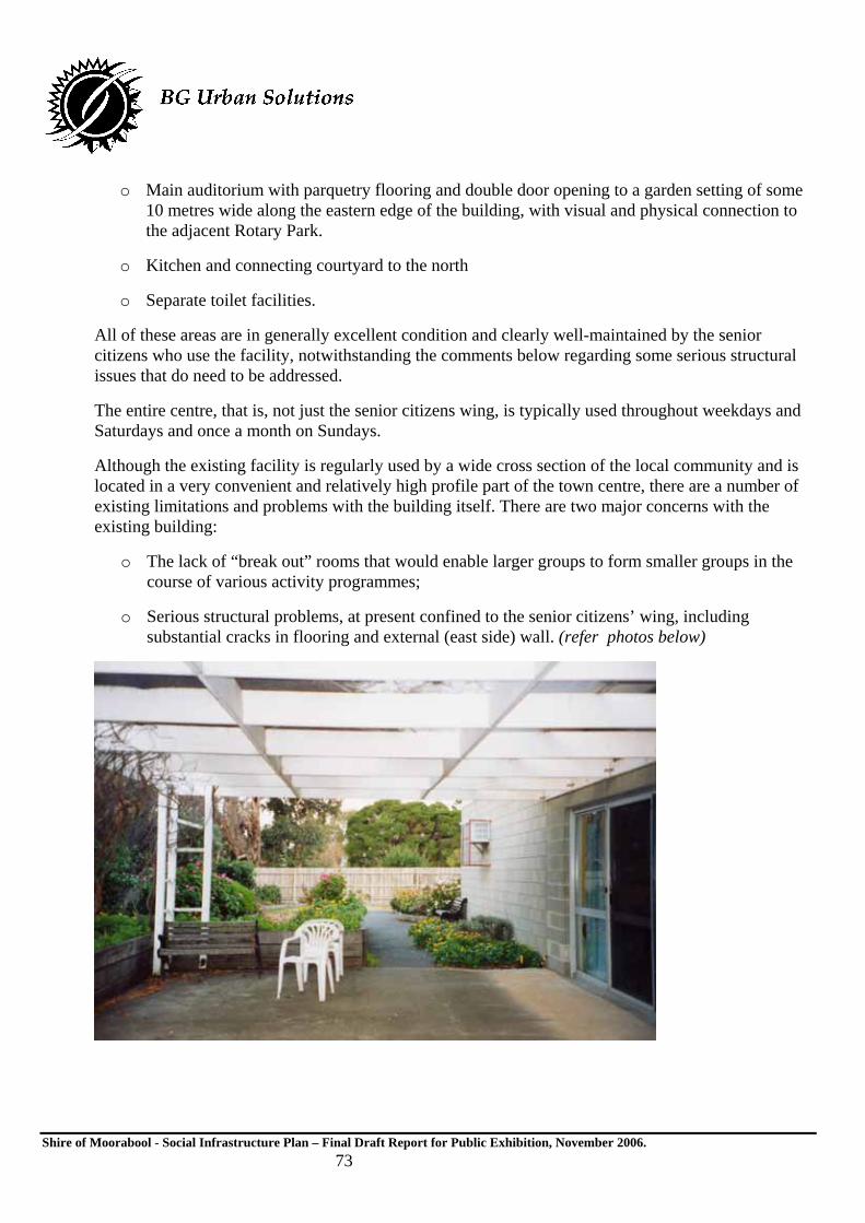
Shire of Moorabool - Social Infrastructure Plan – Final Draft Report for Public Exhibition, November 2006. 73
o Main auditorium with parquetry flooring and double door opening to a garden setting of some 10 metres wide along the eastern edge of the building, with visual and physical connection to the adjacent Rotary Park.
o Kitchen and connecting courtyard to the north
o Separate toilet facilities.
All of these areas are in generally excellent condition and clearly well-maintained by the senior citizens who use the facility, notwithstanding the comments below regarding some serious structural issues that do need to be addressed.
The entire centre, that is, not just the senior citizens wing, is typically used throughout weekdays and Saturdays and once a month on Sundays.
Although the existing facility is regularly used by a wide cross section of the local community and is located in a very convenient and relatively high profile part of the town centre, there are a number of existing limitations and problems with the building itself. There are two major concerns with the existing building:
o The lack of “break out” rooms that would enable larger groups to form smaller groups in the course of various activity programmes;
o Serious structural problems, at present confined to the senior citizens’ wing, including substantial cracks in flooring and external (east side) wall. (refer photos below)

Shire of Moorabool - Social Infrastructure Plan – Final Draft Report for Public Exhibition, November 2006. 74
The building’s structural defects are understood to be largely due to a prolonged drought and are currently in the process of being rectified at a cost of some $65,000.
There are a number of factors to be borne in mind in assessing the acceptability of existing community facilities. In the case of Quamby, key considerations include:
o The central location and what that offers in terms of convenience and ease of access to a cross section of Bacchus Marsh residents;
o The cost and efficacy of spending additional funds repairing a less than optimum existing building and layout;
o The known unmet need for more housing to meet the needs of older adults who seek independent living but in housing more appropriately designed and located such that independent living remains feasible for some time to come despite progressive frailty;
o The potential to generate greater net community benefit from more intensive and diverse development of the site given it is within convenient walking distance to a range of facilities.
4.3.1.7 Rotary Park
This review of existing community facilities does not generally include recreational facilities. However, in the case of Rotary Park, it is considered relevant to consider the level and pattern of existing usage and whether there is a case for considering whether this can and should be altered in some way to better meet the needs of the existing and future Bacchus Marsh Community. Rotary Park

Shire of Moorabool - Social Infrastructure Plan – Final Draft Report for Public Exhibition, November 2006. 75
is an area of some 11,690 square metres (or 1.17 hectares) that abuts the site of the Quamby community centre to the west and Young Street to the east, with the Bacchus Marsh pre-school located in the very south-eastern corner of the site and addressing Young Street. Partly because of its central location and due to its complement of facilities, the park is recognised as a key community asset highly valued by the community (Moorabool Shire Council, Sept 2005; pa 5).
Rotary Park is considered to be in “reasonable” condition, especially given current drought conditions, and has a complement of established peripheral landscaping and provision of play equipment and rotunda. The park is also currently host to what is essentially a temporary skate ramp facility, located on the southern edge of the park, adjacent to Bennett Street and opposite the shopping centre car park.

Shire of Moorabool - Social Infrastructure Plan – Final Draft Report for Public Exhibition, November 2006. 76
It should be noted the skate park facility is positioned at ground level, in contrast to the more usual arrangement for permanent skate facilities to be set into the ground via excavation and either metal or concrete moulding for various degrees of skate skill / difficulty.
The ground level arrangement of the existing facility serves to block views into the park from Bennett Street, with associated loss of natural surveillance opportunities. Some surveillance of the skate park is available from the car park and from passers by along Bennett Street, however this is limited to daylight and trading hours. Other that these design implications, the skate facility is considered to be in a suitable location and is clearly well used by local youth.
There is scope, however, to redress loss of natural surveillance by creating an in-ground facility and by enhancing or accommodating more spectator facilities around the skate ramp. These need only be informal and may serve other benefits such as increased frequency of seating provision that meets a range of user group needs. There tends to be few opportunities for youth to “show off” what they can do well, an important complement or “antidote” to the often negative incidents other groups within the community tend to cite with regard to the behaviour of youth. There is, therefore, a need and in this case a valuable opportunity to further refine the facility and provision of supporting infrastructure to promote greater community awareness of and support for the talents of local young people.
Overall, in order to better maximise use of council land to generate a greater benefit for a cross-section of the community, it is considered there is a case that can be made for a comprehensive redevelopment of the Quamby community centre and certain precincts of the adjacent Rotary Park.
Exactly how this area might be redeveloped / upgraded should, of course, be determined by a separate “master planning” project that is informed by community consultation and, in particular, specific input from current user group. (It is noted that such master planning has recently been commenced by

Shire of Moorabool - Social Infrastructure Plan – Final Draft Report for Public Exhibition, November 2006. 77
Council.) Any future redevelopment should also take into account comments made below in relation to other key facilities, most particularly those in relation to the understood limitations of the Bacchus Marsh Leisure centre currently run by the YMCA including the lack of an adequate and attractive venue for debutante balls and similar functions. However, one possible redevelopment scenario that should, on the basis of the above findings, be considered via such a process would include the following elements:
o New 6 star energy and resource efficient building on the site of the existing Quamby centre, with the following design features and components:
o Two storey format, to maximise available building space and efficient land use and to create natural surveillance opportunities across the adjacent park.
o Building should be located on the site such that size of existing north-facing courtyard is increased and overshadowing of Bennett Street is avoided;
o Retention of “wing” elements that allows designation of spaces to key user groups including senior citizens while not precluding use by other groups as required.
o Provision of one large meeting room (100sqm) plus two flexible and adjoining smaller meeting rooms (2 x 40sqm), all with direct access to north facing courtyard;
o Full commercial kitchen, accessed from both general community centre wing and senior citizens wing
o Smaller kitchenette facilities included in smaller meeting rooms.
o Main supper room suitable for smaller ballroom / other dance events and classes, through to, perhaps, larger functions that can cater for up to 300 people, with physical and visual connection to adjacent Rotary Park to the east.
o Incorporation of supported / independent living units for older adults with street frontage to Bennett Street.
o Possible provision of office space for Council’s Aged Services division, as the main agency responsible for the range of programmes likely to operate from the centre.

Shire of Moorabool - Social Infrastructure Plan – Final Draft Report for Public Exhibition, November 2006. 78
4.3.1.8 Bacchus Marsh Library
The local library service is funded and managed by an arrangement between the adjoining municipalities* to provide services for the following townships: Ararat, Avoca, Bacchus Marsh, Ballarat, Beaufort, Clunes, Creswick, Daylesford, Hamilton, Maryborough, Sebastapol, Wendouree and mobile services. (*Participating municipalities are: Ballarat, Pyrenees, Hepburn, Ararat, Central Goldfields, Southern Grampians and Moorabool.)
The Bacchus Marsh Library is located in Main Street, within the Bacchus Marsh town centre. The building and layout consists of the following characteristics and components:
o is single storey,
o has good disabled access
o has approximately 250 sqm floor area for book shelves, reading area and administration.
o has a total of three computers available for both word processing and internet access.
o does not have rooms available for small group discussion or training.
For a relatively small township population of some 18,000 this might seem adequate, however a key access issue highlighted throughout past and recent community feedback is the mismatch between hours of operation and hours of need given a high commuter proportion of the resident population. For example, a large majority of local residents either commute to Melbourne or attend schools for much of the hours when the library is open: from 10am to 5pm Monday to Friday, whereas the more likely

Shire of Moorabool - Social Infrastructure Plan – Final Draft Report for Public Exhibition, November 2006. 79
hours of need are after 6pm at least one or two hours per week and throughout the weekends. There is, therefore, a need to identify funding strategies to extend hours of operation and to upgrade services and the book collection.
In response to this issue, a recent Library Services Review lead to a recommendation to close the Library one day a week to allow the Library to stay open until 5pm on Saturdays. This partially addresses the accessibility issues identified herein. Other recommendations within the Library Services Review relate to quality and extent of facilities and are dependant on available funding. The importance of a Library service to a community the size of Bacchus Marsh cannot be understated and the recommendations of that review are endorsed by this study. In addition to the significant appeal of libraries to a wide cross section of any community, the fact that Bacchus Marsh is the birth place of two of Australia’s most highly recognised post war authors (Frank Hardy and Peter Carey) suggests that the Library could easily become the iconic reference point in the cultural history of Bacchus Marsh.
4.3.1.9 Moorabool Shire Community Services Offices
In addition to Council administration offices located within the main town centre, Council also owns and operates a compound of community facilities located in Main Street. These facilities include a larger meeting room, commercial kitchen, toilet facilities and ancillary office space.
These facilities date back to the 1970s and have been renovated to some degree in 2004 but remain limited in their design function and performance, particularly with regard to visual connectivity to the street, energy efficiency (and therefore cost to run) and range of community activities that could be accommodated. The significance of these limitations are considered more pressing given the lack of alternative facilities nearby, including the limitations of the adjacent library, being unable to fulfil some community meeting / adult education functions.

Shire of Moorabool - Social Infrastructure Plan – Final Draft Report for Public Exhibition, November 2006. 80
A master planning process for this general civic precinct is understood to be currently in train, however no clear directions were evident at the time of preparing this report.
4.3.1.10 Moorabool Shire Aged Services Offices
Council’s Aged Services division operates from a converted, single storey, 1970s Australia Post office building located in Main Street within the town centre and adjacent to The Village shopping centre. Council purchased this building some years ago and also leases a portion of it to another tenant, the Federal member for Ballarat.
The Aged Services division occupies approximately 100sqm of the building, which is in moderate condition and which does not particularly serve well office administration or community access functions of the division.
4.3.1.11 Tourist Information Centre
This facility has only recently been relocated to the same “old Post Office” building as the Moorabool Shire Aged Services division.
Tourism is identified by Moorabool Shire as a major contributor to the economy and employment in regional Victoria and is seen as playing an important role in the economic development of Moorabool (Growing Moorabool Strategy and Bacchus Marsh Tourism Advisory Committee Strategic Plan). The Visitor Information Centre, established in September 2005 is a key element of the Tourism Advisory Committee’s strategic direction for developing tourism in and around Bacchus Marsh. In the first four months of the Visitor Information Centre’s operation it averaged more than 350 visitors per month. At least 25 per cent of these inquiries related specifically to tracks and trails and recreation activities.
4.3.1.12 Bacchus Marsh Community Radio (Apple FM)
The offices and transmitter of the Bacchus Marsh Community Radio Station are also located within the Council owned old Post Office building in Main Street, Bacchus Marsh. The radio station nominally pays an annual rental to council for the premises, however this “payment” is made via a regular “Listen In” programme on Fridays 12-3 which features Council news and opportunities for local residents to ring in with their comments and ideas on the matter being discussed or any other matter they wish to raise.
The radio station has a 24 hour licence and broadcasts at 98.5FM under the name “3APL/ Apple FM”, referring to apples as the main produce for which Bacchus Marsh is renown. At present, station programming to fill the 24 hours per day licence does include use of pre-recorded music but also includes a number of live broadcasts that cover a range of cultural and age based interests. These live broadcasts tend to be concentrated around afternoons and the weekend. Programmes include:
o Talk Back sessions on Thursdays 3-6pm and Fridays 12-3pm;
o “The Emma and Eleanor Experience” run by three high school students on Mondays 5-8pm

Shire of Moorabool - Social Infrastructure Plan – Final Draft Report for Public Exhibition, November 2006. 81
o A Christian programme on Sunday mornings, followed by an RSL Easy listening programme, Memory Lane (music from the early 1900s), and a combined Simply 50s and an Elvis Presley session 4-7pm on Sunday afternoons.
Station operators indicated an estimated current listening audience of 2000 people, although paid up membership, at a cost of either $25 or $50 per year, stands at less than 50 people.
With regard to adequacy of existing facilities, there is at present a need or preference for at least an additional studio, to enable production of programmes separate from broadcasting activities. In the longer term, the radio station is keen to be accommodated within the vision for a performing arts precinct within the township and some preliminary discussions with Council have been convened towards this end.
From a “community building” perspective, having a local and community-based radio station can be regarded as adding positively to the Bacchus Marsh community’s distinct identity. It also offers valuable “work experience” for young people exploring interests and possible career options and, therefore, a community based radio station can be regarded as a valuable “social capital” asset.
4.3.1.13 The Laurels - Bacchus Marsh Adult Education Centre
The Bacchus Marsh Adult Education centre is a non-profit community based organisation that has its origins in adult education classes initially conducted in 1980 in the Methodist Church Hall in Gall St which has now been demolished. After a new community centre was built, Moorabool Shire Council offered the then “Adult Education Committee” the use of disused Council – owned cottage located 215 Main St in Bacchus Marsh, a building that was in some state of disrepair.
Due to a lack of space and with the support in fundraising from the local community and trades people, in 1994 “The Laurels” committee of management took the decision to purchase and upgrade 229 and 231 Main St. These buildings are now owned by The Bacchus Marsh Adult Education Centre Inc, still known locally as “The Laurels”, and are the venue for the following programmes and training:
o A neighbourhood house, providing a meeting place and venue for many local groups and a range of activities;
o A registered Adult Community and Further Education (ACFE) provider, the centre offers a range of courses that allow participants to upgrade their skills, learn new skills and gain qualifications that provide a pathway to further education;
o As a Registered Training Organisation (RTO) the centre offers a range of entry level vocational courses that enables local access to specially tailored nationally recognised training programmes.
With regard to funding, local fundraising and in kind support has been critical to the ongoing functioning of the centre. In addition to local community support, the organisation also receives funding from the State Government, via the Community Support Fund (Dept Victorian Communities) and Neighbourhood House programme (Dept Human Services), fees from courses and more recently, a

Shire of Moorabool - Social Infrastructure Plan – Final Draft Report for Public Exhibition, November 2006. 82
nominal level of support from Moorabool Shire Council in the form of a grant of $9000, from which Council rates of $3500 are paid.
While the organisation is progressively paying off a mortgage on existing capital assets, recurrent funding remains a constant challenge. ACFE funding covers approximately half the cost of conduction various training courses, with the shortfall needing to be covered by course fees, fundraising efforts such as raffles and fees from hiring out the venue, and any other funding sources that become available. The current range of courses offered is a reflection of community need and an ageing population. These courses typically include:
o Computer skills
o Horticulture
o Aged Care e.g. Certificate 3 in Aged Care work (which is in high demand but existing funding levels mean only one intake per year is possible)
o Introduction to small business/ time management/ keeping the books
o Food and hygiene
o Hospitality e.g. bar attendant/ responsible service of gaming
o First aid
o Work and life skills
o Health and well being.
Apart from the constant challenge posed by the need to improve for recurrent funding to better meet current demand for training, there are two other key issues that need to be addressed to better meet the education and training needs of existing local residents. These are:
o Integration between other training providers
o Better links / addressing causal issues for young people leaving school prior to year 12.
With regard to the issue of integration, although at present there is a high level of communication and co-operation between schools and the other local training provider, Darley Neighbourhood House Inc., there is a need to improve and formalise these links to ensure maximum community awareness of training opportunities available and to make the most of limited operating budgets for all organisations. With regard to early school leavers, The Laurels currently runs a “Get back on Track” programme aimed at reintegration of students either at school or some other vocational training programme. At present, this is working well due to The Laurels being in ongoing discussion with local secondary schools. However, there are two ways in which the current situation could be improved:
o Ensure Dept Education and Training’s VCAL funding “follows” the child;
o Introduce greater diversity in curricular and teaching modes to more successfully engage secondary school students.

Shire of Moorabool - Social Infrastructure Plan – Final Draft Report for Public Exhibition, November 2006. 83
4.3.1.14 Pepper Tree Park
Pepper Tree Park is a major recreational reserve located towards the southern limits of the existing township, within approximately 300 metres of the Bacchus Marsh Leisure Centre and EcoLink and within approximately 500 metres of the Bacchus Marsh Train Station.
The park extends along the banks of the Werribee River and provides some degree of linear connection to other local open space areas within the township. The park has recently undergone some major upgrades and restoration of existing facilities and now offers extensive walkways augmented by information/ environment education panels, barbecue facilities and some degree of disabled access.

Shire of Moorabool - Social Infrastructure Plan – Final Draft Report for Public Exhibition, November 2006. 84
Primary access to the site is via Grant St, the main north-south connector road within Bacchus Marsh, which becomes Gisborne Rd north of Main Street. Along this route, especially south of Turner Street, an off road shared cycle and pedestrian path of approximately 3 metres exists on the western side of Grant Street, thereby providing safe access to the park for a cross section of the community. This path varies in design and construction in places, from gravel to concrete.

Shire of Moorabool - Social Infrastructure Plan – Final Draft Report for Public Exhibition, November 2006. 85
4.3.1.15 Maddingley Campus - Bacchus Marsh Secondary College
The Maddingley campus of Bacchus Marsh secondary college is located on the corner of Grant and Griffith Streets, on the southern edge of the existing township of Bacchus Marsh but almost central to the planned future growth of this area, with new residential development areas approved to the south and west of this school. The school is also located within 400 metres of the Bacchus Marsh train station and, perhaps more significantly, is co-located with the Bacchus Marsh Leisure Centre and Eco Link science and technology innovations centre.

Shire of Moorabool - Social Infrastructure Plan – Final Draft Report for Public Exhibition, November 2006. 86
The school currently has an enrolment of 784 students with the overall enrolment trend being stable. There is a tendency for some of the older students to leave school through the year in order to take employment positions, however enrolments do tend to be stable at around 800 students and this is the expected enrolments for the start of the 2006 school year.
4.3.1.16 Bacchus Marsh Leisure Centre / YMCA
This facility is located in Labelliere St and abuts the Bacchus Marsh Secondary College along its southern boundary. The centre was built in the1980s by the State Government Dept of Education and Training and is operated by the YMCA via a shared use agreement between the Dept Education and Training and Council.
The centre provides a range of sporting facilities used by the adjacent secondary college as well as the general community. Key components include:
o 2 Basketball courts* (sprung wooden floor) with limited upper level spectator seating;
o 4 Badminton courts*
o 1 Volley Ball court*
o 1 Indoor Soccer (junior & senior)
o Korf Ball (Hosted Interstate championships in early 2005 which attracted 600 visitors to Bacchus Marsh)

Shire of Moorabool - Social Infrastructure Plan – Final Draft Report for Public Exhibition, November 2006. 87
o Group Fitness Room / doubles as School Drama Room
o Boxing Circuit Room
o Canteen and associated seating area
o Occasional Child Care Centre - two playrooms linked, provides:
o 21 place child care
o Crèche facility
o Current demand averages 6-10 children per day with variable demand during school holidays
o School PE office
o Upper level (access via lift and stairs)
o Gymnasium – approximately 400 members ranging in age from 12 – 83 years of age, with some spare capacity during the day but at capacity at peak hour session times before and after standard work hours.
o Viewing area to courts
It should be noted that the leisure centre commenced offering debutante ball dance classes and training in1996 and since then interest in this training and event has grown steadily, to the point where 3 “intakes” are offered per year of up to 25 couples. Feedback from the YMCA manager also indicated growing interest in this cultural tradition was occurring in spite of a lack of venue in Bacchus Marsh for the actual ball, with Luxor..Receptions in Melton currently filling this void. These occasions typically attract up to 550 guests and there was a need / demand for a local facility to accommodate this event, given a preference for a small country town atmosphere for such an event.
It is considered the absence of such a facility, together with associated need for visitor accommodation, can be regarded as both an unmet social need and a missed economic opportunity for the township of Bacchus Marsh. This significance of this issue of lack of facility and untapped economic opportunity is more pronounced given similar lack of capacity for major gatherings such as end of year school speech nights.
4.3.1.17 Eco Link Science and Technology Innovations Centre
This facility is located adjacent to the Bacchus Marsh Leisure Centre, in Labelliere St, and was primarily funded by the Dept of Education and Training ($4m) with supporting sponsorship from other agencies including Western Water, who supplied the rain water tanks.

Shire of Moorabool - Social Infrastructure Plan – Final Draft Report for Public Exhibition, November 2006. 88
The centre was designed to serve as an “active learning” demonstration building that augments existing facilities available at both Darley and Maddingley campuses of the Bacchus Marsh Secondary College, as well as being available for use by the broader community. The design and fit out of the centre is no less than “cutting edge” in terms of sustainability design principles.
The centre opened in January 2005 and is complemented by surrounding stormwater wetland environs and weather station. Its key internal components and features include:
o Weather Wall, a CSIRO invention.
o Conference Room seats 100 theatre style, can be divided into two smaller rooms.
o Double glazed and adjustable windows.
o Heat bank ceiling and gas heater augmentation.
o Use of sustainable and recycled building materials and finishes.
o Two science labs each seating 30 students.
o Resource room that seats up to 30 students and is fitted with audiovisual equipment, laptops.
o Smaller work room for younger students.
o Glasshouse.
o Rainwater tanks and reuse systems.
o External “Sustainability Trail” and compost toilets.

Shire of Moorabool - Social Infrastructure Plan – Final Draft Report for Public Exhibition, November 2006. 89

Shire of Moorabool - Social Infrastructure Plan – Final Draft Report for Public Exhibition, November 2006. 90
4.3.1.18 Maddingley Park
Maddingley Park is located within the area bounded by Taverner, Bond, Station and Grant Streets, at the southern edge of the Bacchus Marsh town centre. The park is an attractive and historic formal recreation facility with a combination of organised sporting precincts, substantive plantings, playground, picnic and toilet facilities. These include:
o Tennis courts and club house
o Football and cricket oval
o Occasional rotundas and ticket office at entry points
o Young children’s playground.
Historic features also include heavy and ornate iron gates at both the Grant and Station Street entrances, which were donated by the Pearce family, and perimeter railing around the cricket / football oval that originally came from the Melbourne Cricket Ground.
The Shire of Moorabool has conducted a Heritage Study of Bacchus Marsh which identified Maddingley Park as having regional historical, social, aesthetic and architectural significance. Recognised heritage elements of the Park (including the Tennis Club) include the garden structure, street furniture, fences/gates/hedges, scenic trees and remnant vegetation. Built in 1857, the original Maddingley Courthouse which is a stone Classical building is now used as the tennis clubrooms.
4.3.1.19 Bacchus Marsh Walking Trails
Maps 7.2 and 8.3 of the Bacchus Marsh District Trail Plan (January 2005) show existing and planned future extension of the local trail network for pedestrians, cyclists, longer distance hikers and horse-riders. The existing network includes peripheral sections of road and open space networks such as part of Pepper Tree Park, along southern edge and north bank of the Werribee River.
Although there are no actual figures relating to the usage of tracks within Bacchus Marsh, the anecdotal information available to Council officers shows the tracks and trails within Bacchus Marsh are heavily used for commuting to community facilities such as schools, and the trails around Bacchus Marsh are popular recreational assets used by both local residents and visitors to the area.
4.3.1.20 Bacchus Marsh Railway Station
The Bacchus Marsh train station is located some just over 1 km south of the main town centre and on the existing southern edge of the township. The station is, however, located somewhat more central to the planned future development of the township, with the Bacchus Marsh Residential Growth Strategy indicating substantial residential development to the east and west of the station precinct by 2011 and longer term growth directly to the south.

Shire of Moorabool - Social Infrastructure Plan – Final Draft Report for Public Exhibition, November 2006. 91
The station is also located immediately opposite Maddingley Park and flanked to the west by an attractive but poorly defined walking route to the west, towards Grant Street, giving the station an attractive and rustic and picturesque outlook and context for patrons and, therefore, positively contributing to a quaint country town character.
The building is of an Edwardian brick style and construction and, from the findings of the Bacchus Marsh Heritage Study (Peterson and Catrice, 1994), was built in 1889 by building firm Parker and Vickers. The heritage study findings cited a number of significant intact elements, including: form, façade, verandah, roof form, plan / layout, use, chimneys, windows, unpainted finish, outbuildings, equipment and engineering structure. Overall, the heritage study concluded the Bacchus Marsh train station was valuable for its local significance for its historical, architectural, social and scientific features and was recommended for protection / control under the local planning scheme.
The internal fit-out of the station, however, is somewhat out dated, inconsistent with the buildings heritage character and in need of an upgrade to better meet the needs of all users and provide greater level of comfort and convenience for patrons. Existing facilities include a small seated waiting area that accommodates approximately 20 people, a ticket office and public toilets. Disabled access in and around this area is possible but awkward given limited width of passage ways, however access from the street/ car park through station entrance to platform and train is considered quite good. There is, however, no café and a section of western end of the building is closed off and apparently unused.

Shire of Moorabool - Social Infrastructure Plan – Final Draft Report for Public Exhibition, November 2006. 92
The existing car park accommodates approximately vehicles within the immediate vicinity of the train station, plus additional formal car park provision for another 70 vehicles, or so. In addition, site visits undertaken on weekdays mid June and mid August 2005 consistently found some “spill-over” demand for car-parking in the area immediately to the west of the existing car park and on street parking along Grant St of a further dozen ,or so, vehicles. This level of car parking provision appears adequate to meet current commuter demand.
Pedestrian pathways and access routes are limited, with no formal provision of such along the south side of Station Street (adjacent to the station) and no pedestrian crossing at the intersection of Station and Grant St, the major north – south arterial road that becomes Gisborne Rd north of Main Street and which connects to Darely neighbourhood to the north of the Western Highway. Nor is there adequate lighting of pedestrian walking routes. Local feedback indicates there are a number of commuters who do walk to and from the station. However, the lack of proper supporting infrastructure for pedestrians is considered a significant issue for two main reasons:
o The lack of pedestrian crossings and overhead lighting posing a threat to pedestrian safety; and
o The missed opportunities to foster improved transport / movement patterns that would generate better outcomes in social (safety and healthier lifestyles) and environmental terms (reduced greenhouse emissions), as well as potentially reduced traffic congestion or at least containment of traffic volumes as residential development continues and the actual number of trips to and from the station increases.
Given the existing predominance of local residents commuting to Melbourne (and to a lesser extent, to Ballarat) for work by car, as per data presented in section 2.1 of this report, encouraging use of existing train services is considered critical to safeguarding “quality of life” aspects of living in Bacchus Marsh, as well as fostering other social and economic benefits from providing an attractive and feasible alternative to car dependency.
Train services to Melbourne during weekdays currently commence at 5.08am and run approximately every 10 – 20 minutes until 76.41am and then reduce to hourly, or thereabouts, with the last train weekday service to Melbourne departing at 8.55pm. A similar frequency applies to the journey from Melbourne, with the last weekday service arriving at 10.27pm. Journey times are typically around 45minutes, depending on the degree of “express service”. Services to Melbourne on the weekend are fewer but still relatively frequent, with 8 services on Saturday, commencing 6.35am and finishing at 6.10pm, and six services on Sunday, commencing 8.08am and finishing at 8.20pm ((VLine Train timetable, September 2004).
Council officer feedback also cited the current, though somewhat limited, tourism related travel by train, given the nearby link to the Great Victorian Walking Trail, adjacent to Pepper Tree Park. This suggests there are other tourism related economic benefits that potentially could be cultivated from the existing and upgraded train station, improved pedestrian access surrounding the station through to and safely across Grant St, and encouraging some visitor accommodation within the immediate vicinity of the station.

Shire of Moorabool - Social Infrastructure Plan – Final Draft Report for Public Exhibition, November 2006. 93
4.3.1.21 Bacchus Marsh Grammar School
This school is located on an elevated site immediately to the south of Maddingley Park and the Bacchus Marsh train station, on South Maddingley Rd. The school was established in 1988 and was relocated to its present site in 1991.
The school is a private, P-12 facility, with a current total enrolment of 950 students. Based on current trends, enrolments are expected to grow to 1050 by 2007, at which point the school will be considered at capacity and no further investment to expand on this capacity will occur. It is understood approximately 40 percent of students attending the school come from the local area, while around 60 percent come (by school bus) from elsewhere in the region such as Werribee and Melton.
With regard to school facilities and community use of them, the school has the full complement of classrooms, gym and associated facilities. There is some community use of the gym however this is not on a formalised/ “hire out” basis.
With regard to the need for additional facilities and future planning for these, there are three key areas / facilities that need to be provided or improved:
o A suitable venue for performing arts and debutante balls;
o The need to improve library services
o The need to provide an additional full size oval.
With regard to the first of these issues, like the YMCA (refer 4.3.1.16), the school does hold two debutante balls per year. However, like the YMCA, the school has found that due to the lack of a suitable venue (that could accommodate up 600-700 guests) in Bacchus Marsh, it is necessary to hold these events outside the local area.
Strategic planning by the school to address this issue and the need for an additional oval includes a willingness to jointly fund the provision of additional facilities “off site” that would also be used by the local community. Some preliminary discussions have recently been convened between the school and Moorabool Shire towards this end.
Clearly, in a growing area where Council will inevitably struggle (and is currently struggling) to meet all the social and physical infrastructure needs of local residents, it makes fiscal sense to co-operate and co-ordinate with all relevant agencies and potential funding sources. It should be acknowledged that while numerous successful examples exist of such co-ordination and joint use do exist, attention does need to be paid to ensuring equitable, accountable and manageable joint use arrangements are set in place, to ensure to the social and economic advantages of pooled resources do in fact materialised.
For example, one widely recognised successful examples of such co-ordination is located in Drysdale, where the Dept of Education and Training’s Bellarine Secondary College is co-located with The Potato Shed – Bellarine Multi- Arts Centre and the St Thomas (P-12) Catholic Regional College (refer Melway map 470, F3). In summary, the combination of Council land and the remnants of an historic bluestone building that was once used to store potatoes, located centrally between the two schools,

Shire of Moorabool - Social Infrastructure Plan – Final Draft Report for Public Exhibition, November 2006. 94
serves as an excellent example of how both the schools and the broader community can benefit from a high level of co-operation and joint planning such that a community facility (in this case an arts centre with full theatre lighting, exhibition space and quality dance floor) can be affordable, when each of the tree parties to the agreement would not have been able to countenance funding such a facility in their own right.
The key, of course, is ensuring building design makes functional sense to all parties and that there are clear use and management arrangements set in place. In the case of The Potato Shed, these use arrangements are, in short, the facility being available for use by the two schools 80percent of the time during the week and 20percent of the time being available for community use, with the reverse arrangement applying to the weekends. (For further details contact City of Greater Geelong or Dept Education and Training).
As noted in section 4.3.1.16 regarding limitations of the existing YMCA / Bacchus Marsh Leisure Centre, there are significant social and economic costs currently being borne by the Bacchus Marsh community due to a lack of a suitable local venue for events such as debutante balls. In the case of the YMCA, there is a need for such a facility at least three times a year each attracting in excess of 500 people. Added to this are the needs of the Bacchus Marsh Grammar School for two events per year, each of which attracting 600-700 people, as well as other predictable events such as end of year school speech nights of Christmas concerts for each of the local schools. This issue and recommendation for optimum response is discussed further in section 5.3.5 of this report.
With regard to library services, while the school does have its own library the Bacchus Marsh Library is limited in terms of its collection and opening hours, thus preventing local students from developing their independent research skills. There is support from the Bacchus Marsh Grammar School for establishing a linked library service between all local schools and the municipal library service, with anticipated benefits for both students and the broader community.
With regard to the need for an additional oval, given the school site does not have the space necessary to provide this facility but the nearby Maddingley Park is considered to have adequate space available to accommodate a second oval, Bacchus Marsh Grammar School has recently put forward a proposal to Council to contribute half the establishment costs for this additional oval. It is understood the proposal was initially canvassed with the Maddingley Park management committee and, given the support of this committee, was subsequently put forward to Council. At present, it is understood Council has yet to fully consider the proposal.
With regard to other social infrastructure needs, it is important to acknowledge feedback from the Bacchus Marsh Grammar School included an existing lack of much needed community services in the following areas:
o Lack of family support services for families in distress;
o Need for other affordable and exciting recreational activities, as constructive alternatives to binge drinking;
o Improved level of provision and access to mental health support services, especially for youth.

Shire of Moorabool - Social Infrastructure Plan – Final Draft Report for Public Exhibition, November 2006. 95
4.3.1.22 Bacchus Marsh Pool
The Bacchus Marsh pool is well located, on Grant Street adjacent to Pepper Tree Park and within 200m of Bacchus Marsh Secondary College – Maddingley Campus. The location is also central to the Bacchus Marsh town centre and Maddingley growth and is also en route to and from Darley, via Grant Street – Gisborne Road. At present, pedestrian and cycle access to the pool (and Pepper Tree Park) is quite good given the existence of comparatively wide (three metre) off road pathways, some distance concrete-paved or gravel, along the Grant Street approach route.
However, the existing facility is limited to a six-lane 50 metre outdoor, non-heated pool. As such the pool offers limited benefit to the community in general, and in particular to those who would benefit from more regular non-weight-bearing exercise and those with some form of physical disability as the existing pool does not offer disabled access.

Shire of Moorabool - Social Infrastructure Plan – Final Draft Report for Public Exhibition, November 2006. 96
4.4 Existing Community Facilities: Ballan
The Shire of Moorabool consists of three substantive townships or urban settlements, these being Bacchus Marsh, Darely and Ballan, along with a number of smaller settlements and rural residential and agricultural areas. Whereas Bacchus Marsh and Darely are adjacent settlements separated by the Western Highway, Ballan is a discrete historic township located some 20 kilometres (??) further west of the Bacchus Marsh – Darley settlement. The main access route is also via a turnoff from the Western Highway.
4.4.1 Ballan
The township of Ballan essentially consists of some 2000 people settled in two main precincts: the traditional town centre and its immediate periphery and a more contemporary and lower density settlement to the north of the town centre and the Werribee River.
Physical layout of the township includes the following key features:
o A compact grid based main town centre and “heritage character” residential areas, flanked by the railway station on southern edge of township and Werribee River defining the northern edge of the historic township;
o More recent residential development further to the north towards Ballan Golf Club and south of the Western Highway;
o A good mix of local shopping facilities
o A local train station, with apparently adequate commuter car parking and regular train services to Melbourne and Ballarat. It is noted a new timetable came into effect in September 2006. Services to Melbourne on weekdays, an hour journey, now commence before 6am and extend to approximately 8pm, with reduced but still several services available on weekends. A counter peak service also now operates to Ballarat, arriving just after 8am, which makes it feasible for students from Bacchus Marsh and Ballan to travel to schools and higher education in Ballarat rather than Melbourne for the first time. This service came into effect in January 2006. It should also be noted there is some excess peak level of demand for car parking at the station and associated pedestrian safety issues, especially at night.
Current development and population trends have been documented in section 2.1 of this report, however, in short, past trends and strategic planning indicates Ballan is expected to continue to grow at by some 50 households or more than 100 people per year.

Shire of Moorabool - Social Infrastructure Plan – Final Draft Report for Public Exhibition, November 2006. 97
4.4.1.1 Mechanics Institute (Ballan and District Community House) & “The Shed”
The historic Ballan Mechanics Institute Hall is located in the heart of the Ballan township, in Inglis Street, and has recently (2003) been refurbished and fitted out to function as the home of the Ballan Community House at a cost of nearly $1million, funded by a number of agencies including the State Government’s Community Support Fund, Council and other agencies. The Ballan Mechanics Institute and Free Library Inc is the governing body for this community facility, with the Ballan and District Community House and Adult Education Centre being a tenant, operating a range of programmes at the facility.
After the recent upgrade, the building is now in what can be considered excellent condition, offering a very high standard of amenity and social function. Key elements include:
o “The Shed” workshop, located at the rear of the building;
o A larger meeting room that comfortably accommodates 16-20 people seated board room style;
o A smaller meeting room that would accommodate up to 8 people seated in meeting format;
o A training room equipped with 8 desks and computers plus one desk for trainer, this room regularly used for a range of programmes including adult literacy and introduction to computers;
o A craft room, with wet floor capacity;
o A supper room complemented by full commercial kitchen;
o Two additional kitchenette / tea and coffee alcoves;
o Toilets including disabled toilets and baby change facilities;
o The main (original Mechanics Institute) hall with stage with hardwood sprung floor and markings for volley ball.
General community access to the building is available from both the front and rear (via Steiglitz Street) with the latter tending to be the more usual entrance for most users and also offering easy disabled access.
There is currently a shared car park arrangement, with 21 car spaces (none of which are specifically designated as a disabled car space), that also serves the parking needs of the adjacent Ballan Senior Citizens Centre in addition to ample on street car parking in Steiglitz Street.
A wide range of events, activities and learning programmes are currently conducted at the centre, with activities run to coincide with school terms and varying throughout the year. These activities and training programmes are grouped under approximately 6 themes, these being:
o Computers;

Shire of Moorabool - Social Infrastructure Plan – Final Draft Report for Public Exhibition, November 2006. 98
o Food Glorious Food
o Craft
o Drop in Sessions
o Health and Well being
o Special interest (which covers a wide range of topics e.g. book discussion group, women’s group, “singing from the heart”, gardening, conflict resolution and model railways);
o Vocational Training (e.g. First Aid ad CPR)
o In the Shed (e.g. making a doll’s house, woodworkers drop in, wood turning group);
o Literacy and numeracy.
Centrelink also currently operates from offices at the front of the building and the work of local artists is on display throughout the building.
In sum, the building complex is in excellent condition, is well located in terms of convenient access and appears well used and highly valued by the local community.
4.4.1.2 Ballan Senior Citizens’ Centre
The Ballan Senior Citizens centre is a purpose – built facility which opened in1984. It is a brick veneer building of some 100 square metres, with ramp access, located in Steiglitz Street, adjacent to the rear entrance to the Mechanics’ Institute / Ballan Community House.
The Ballan Senior Citizen’s Club has around 90 members and provides lunch and social programmes, at present, three days a week. Social activities include bingo, billiards and indoor bowls. In addition, the building also hosts the (adult) day centre programme that operates at the centre on Wednesdays. The building is also used by other community groups from time to time.
4.4.1.3 Ballan Indoor Leisure Centre
The Ballan Indoor Leisure Centre is located at the eastern end of Steiglitz Street, immediately adjacent to the Ballan Primary School. The facility was built in the 1980s and is in excellent condition. The building comprises: single court indoor stadium, small administration office, kitchenette and activity room. The YMCA conducts a range of activities primarily focussed around before and after school and holiday recreational programmes for school children. The centre also has excellent disabled access to, and in and around, the facility.

Shire of Moorabool - Social Infrastructure Plan – Final Draft Report for Public Exhibition, November 2006. 99
4.4.1.4 Ballan Primary School
The Ballan Primary School is a relatively modern facility of brick construction in good condition and set in picturesque grounds fronting Edols, Duncan and Steglitz Streets. The school is adjacent to the Ballan Indoor Leisure Centre to the northeast of the site. The school currently has 212 students attending, with the enrolment trend being in a slightly downward direction.

Shire of Moorabool - Social Infrastructure Plan – Final Draft Report for Public Exhibition, November 2006. 100
4.4.1.5 St Bridgid’s (Catholic) Primary School
St Bridgid’s Primary School and Catholic Church are located towards the northern edge of the historic township precinct, at the northern end of Stead Street. The school sits on an elevated site overlooking the Werribee River and Caledonian Park but which are separated by the Ballan – Greendale Rd, which ultimately connects with Stead Street. The school currently has 85 students with the enrolment trend being in an upward direction.
It should be noted the Ballan – Greendale Rd is the main connector between residential settlement north and south of the Werribee River. This poses some threat to pedestrian safety during peak hour commuting times. Current residential development and associated traffic volumes are considered manageable, however it appears there is a need to proactively move to “calm” through traffic by prioritising pedestrian crossing and access to the parkland at key points such as adjacent to the playground area.

Shire of Moorabool - Social Infrastructure Plan – Final Draft Report for Public Exhibition, November 2006. 101
4.4.1.6 Ballan Pre-School, MCH and Child Care
The Ballan Pre-school and Maternal and Child Health centre are co-located at the northern end of Cowie Street, on the corner of Simpson St, at the western edge of the historic town centre. The building complex was established in 1980s and is in generally good condition. However, functionality of the building is considered poor in that waiting area for parental pick up is exposed to the weather and there is limited space for parent education sessions or other programme activities.
Physical / disabled access to the facilities is excellent. There is also ample on-street car parking plus that provided by a shared off street car park, which appears to quite adequately meet the needs of parents using these facilities. Council officers advised a draft concept plan has been prepared for the renovation of the building to improve functionality.
The Ballan Child Care centre is a newly established facility (opened in 2004) located adjacent to the above complex, fronting Simpson Street. The centre can cater for up to 50 children but currently is operating at only 60-70 percent capacity.

Shire of Moorabool - Social Infrastructure Plan – Final Draft Report for Public Exhibition, November 2006. 102
4.4.1.7 Ballan District Health and Care: Hospital and Aged Care Hostel
This facility is located on the southwest corner of Cowie and Simpson Streets, diagonally opposite the early childhood facilities mentioned in the previous section of this report.
The hospital has 7 private acute beds, which can be changeable subject to need, and 50 aged care beds, of which 10 are dementia specific. The facility typically operates at capacity and it is understood there is unmet need for both high level care and supported accommodation. Ballan Family Care, which provides medical services by two general practitioners is also co located at Ballan District Health & Care.
The building complex is of a single storey brick construction and is in good condition. There is some additional space available on the existing site suitable for expansion of the current primary care and acute care facilities. Space for expansion beyond this is limited.

Shire of Moorabool - Social Infrastructure Plan – Final Draft Report for Public Exhibition, November 2006. 103
4.4.1.8 Ballan Railway Station
The Ballan railway station is located within 500 metres from the town centre (Inglis St) and is attractively positioned at the southern apex of Fisken St, making it readily visible (or “legible”) as the driver or pedestrian tours south into Fisken Street. The station building is similar in architectural style and date to the one in Bacchus Marsh and so too, is recognised for its local heritage significance in the local planning scheme, although the existing internal fit out is somewhat dated and out of character with the building’s heritage significance.
Weekday frequency of train services are approximately hourly, commencing with a service to Melbourne before 6am and the journey typically taking just over an hour. Weekend services to Melbourne also operate but at a lesser frequency than weekdays. In January 2006, a new counter peak hour service to Ballarat also commenced, with a service arriving in Ballarat just after 8am on weekdays, making it feasible for students from Bacchus Marsh and Ballan to travel to education facilities in Ballarat.
Recent renovations have taken place at the station to improve access to both the men’s and women’s toilets from the waiting room and a disabled toilet. The car park has also been upgraded to full bitumen, kerbing and (much need) lighting and marked spaces for each car park. It should also be noted that, in September 2006, it was announced that the Ballan Station would be upgraded to a “Parkway” station to promote increased proportion of community by train (rather than car) to Melbourne, with a planned additional 160 car spaces to be provided beyond existing car park capacity. An additional footpath was recently constructed by Council to improve pedestrian safety and access. Plans to widen Atkinson St, between Stead and Cowie Street have also been budgeted for in the current financial year.
Disabled access to the station platform and access from the platform to waiting area and ticket office, is quite feasible via side gate entry points from the car park area, however the central entrance does not allow for wheelchair access.
4.4.1.9 Ballan Recreation Reserve
The Ballan Recreation Reserve is located on the south western edge of the township and within approximately (check) 400m of the Ballan train station. The total reserve area amounts to nearly 4 hectares (38,969sqm) and incorporates a wide range of sporting and recreational facilities including:
o 6 tennis courts
o 1 net ball court
o 1 football oval and cricket field
o 1 shared pavilion with change rooms, kitchen and toilet facilities (fair condition)
o 1 scout hall (poor condition but arguable heritage value)

Shire of Moorabool - Social Infrastructure Plan – Final Draft Report for Public Exhibition, November 2006. 104
o 1 lawn bowls green and associated facilities
o A new skate ramp facility, completed September 2006.
With such an extensive complement of facilities, this precinct functions as a popular social hub, especially on weekends. The precinct has some attractive features such as mature cypress pine planting that edges the reserve and oval that make for a picturesque and quintessential country setting.
However, there are some problems and limitations with existing facilities, including traffic management around the central driveway access, poor location of toilets (next to kitchen) and need to improve pavilion / change-room facilities associated with tennis courts. It is also understood some of the mature cypress pines are showing the signs of age and becoming prone to collapse in high winds. There is, therefore, a need to review existing landscaping and plan for continuity in this regard and to ensure landscaping generally supports the social function, comfort (shade provision in appropriate locations) and safety of the precinct.
4.4.1.10 Ballan Court House
The Ballan Court House is a charming historic building located close to the town centre, in Steiglitz Street. The building is currently the subject of comprehensive restoration works funded by Heritage Victoria, Dept Sustainability and Environment and Council. This building is located on a spacious site but with an under-developed garden area and less than attractive contemporary chain mesh fence that does not match the character of the building.
Restoration works have recently been completed with future community uses yet to be determined. At present the Court House building is used solely by the Ballan Historical Society, who hold a substantial collection of historical memorabilia however much of this is unable to be displayed due to lack of space.

Shire of Moorabool - Social Infrastructure Plan – Final Draft Report for Public Exhibition, November 2006. 105
4.4.1.11 Caledonia Park/Mill Park
Caledonia and Mill Parks form a picturesque linear expanse of undulating parkland that extends along the Werribee River as it traverses through the Ballan township.. By September 2005, the willows had been removed and 25,000 native trees had been planted along the river through Caledonia Park. This will improve the amenity of the town and generally upgrade the environmental health of the river.
There are some pathways throughout but these could be extended along the river banks and generally be upgraded. There is an attractive play ground and some picnic and barbecue facilities located on the southern side of the river near the junction with Simpson Street in Mill Park.
There are also public toilets nearby, however the toilet block design is not consistent with CPTED* principles and therefore present some concerns with regard to perceived and actual safety (*Crime Prevention Through Environmental Design).

Shire of Moorabool - Social Infrastructure Plan – Final Draft Report for Public Exhibition, November 2006. 106
It should also be noted, as per comments made in section 4.4.15 above, the southern section of the park abuts the St Bridgid’s Primary School and the Ballan-Greendale Rd separates the two parks. This road is a “higher order” road and, despite the descent to the river crossing and curvilinear route, traffic behaviour observed mid June indicates a need to more effectively “calm” traffic to safeguard pedestrians (especially school children) if the charm, accessibility and tranquillity of this area is to be safeguarded for all users.
4.4.1.12 Caledonian Reserve Caravan Park
The Caledonian Caravan Park sits on Crown land and is located on an elevated site immediately adjacent to and overlooking the expansive Caledonian Park, on the southern side of the Werribee River, at the northern end of Jopling Street in the main township of Ballan. The caravan park consists of 14 cabins, plus a further 6 van powered sites, with capacity for up to 30 tents or caravans. From Spring onwards, visitors from all over the world travelling around Australia form part of the regular tourist profile staying at the caravan park.
At present the caravan park is mostly full, occupied by approximately 17 permanent residents (3 in own caravans, 14 in cabins provided) plus there is additional scope for overnight / short term stays. These tend to vary from a peak of 5-10 residents per week, during the warmer months, to markedly fewer in winter.
Visitor feedback is quite positive, reporting they love the quiet peaceful atmosphere. It was also considered a boost to the township and the facility to see some improvements along the river. However, it was suggested this should be extended to add a lake / water feature and additional pedestrian bridge to better link walking paths and create more interesting walking routes.

Shire of Moorabool - Social Infrastructure Plan – Final Draft Report for Public Exhibition, November 2006. 107
4.4.1.13 Ballan Swimming Pool
The Ballan swimming pool is located within Caledonia Park, in a picturesque setting between the Ballan Golf Club and the Mill Park children’s playground. Like the Bacchus Marsh pool, disabled access is provided via hydraulic lift only. However, unlike the Bacchus Marsh facility, the Ballan pool is a purely recreational facility and does not have training lanes marked.

Shire of Moorabool - Social Infrastructure Plan – Final Draft Report for Public Exhibition, November 2006. 108
5. Recommended Social Infrastructure Provision It is important to remember the following recommendations are the result of an extensive process that commenced well before the commissioning of the Social Infrastructure Plan in early 2005. That process included the consultations and Council deliberations that ultimately lead to the adoption of various Council policies and strategies over the last five years in particular. In sum, however, the recommendations have been informed by:
o A review of established Council policies, as outlined in section 2 of this report; o Previous and more recent resident and service provider feedback in relation to other key
projects such as the preparation of the Social Development Plan, Health and Well-being Strategy and the MSS Review; and
o An audit of existing facilities and services, presented in section 4 of this report.
The recommendations have been further tested and informed via more recent internal and external service provider feedback in response to the distribution of the draft version of this report. This includes noting consistency with independent reviews of services or service planning, such as a library service review and a municipal “Early Years Plan”, that have been in progress concurrent with the SIP process, likewise in relation to the preparation of a Recreation and Open Strategy. For example, this strategy is currently still in the process of being finalised. However, preparation of this strategy has highlighted the need to ensure a high level of integration and co-ordination across all strategic policy documents and infrastructure planning. A key principle underpinning both the draft Moorabool Open Space and Recreation Strategy and the Social Infrastructure Plan is that the overall health and well-being of the Moorabool community is dependent on access to active recreation and commuting opportunities. And finally, an over-riding objective adopted by the author was to seek to generate recommendations that minimise financial costs to Council and all other potential funding bodies, while at the same time maximise benefits to the greatest cross section of the community. The recommendations are intended to respond to areas of highest unmet need now, along with that anticipated as a result of expected new urban development and population growth, in a manner the generates positive outcomes for the community in social, cultural, economic and environmental terms. The recommendations are also intended to highlight key social infrastructure issues and to respond to particular groups experiencing a demonstrable high level of unmet need now. From the investigations outlined in previous sections of this report, these groups are understood to include:
o Older adults – accessible recreational opportunities and more appropriate housing choices; o Youth – affordable and safe local recreational opportunities; o Affordable housing; o Families – creating family friendly community hubs via multi-purpose community centres; o Community transport for frail aged and others unable to drive; o Social support for homeless and mentally ill; o Pedestrian and cyclist access and safety;

Shire of Moorabool - Social Infrastructure Plan – Final Draft Report for Public Exhibition, November 2006. 109
While the recommendations have been determined in light of likely population growth scenarios for each of the three planning precincts (Darley, Bacchus Marsh and Ballan) it is important to recognise the need for Council to continue to closely monitor population and development trends on an annual basis in order to identify any change in local demographic trends as soon as practicable. It is also recommended the SIP should be reviewed every five years. The following recommendations are set out in order of priority, commencing with a number of general recommendations that are intended to enable Council to better plan for and, most importantly, fund implementation. The timeline applicable to the recommendations is effectively to 2021 only, however timed implementation is also tied to actual rate of population growth to allow for some flexibility and responsiveness as rates of development and population growth can tend to vary for a variety of reasons not least of which being the price of land and cost of transport relative to that in Melbourne and other regional centres such as Ballarat and Bendigo. Note that, wherever applicable, the recommendations herein should be referred to Council for consideration as part of the 20-year Capital Improvement Program, 20-year Financial Plan and Development Contributions Plan (to be prepared). Further, it is intended the Social Infrastructure Plan is used as a reference document in the course of any future preparation of structure plans within the Shire. 5.1 General Recommendations The following subsections present recommendations that apply more generally to the Shire of Moorabool as a whole rather than any one of the three main settlements or “planning precincts” that have been the focus of the SIP preparation. Note that the recommendations are not necessarily or solely directed at Council in all cases, however Council is recognised as a key advocacy agency in conjunction with other relevant agencies where specified. Note also in relation to some of the recommendations below, the intention is to enable Council become more strategic in responding to community needs by preventing problems occurring in the first place (e.g. pedestrian safety, older adult social isolation or unfunded infrastructure requirements) or reducing the inefficiency of recurrent costs to Council by facilitating improved and pre-emptive capital investment (e.g. aiming to reduce the recurrent costs to Council of supervised crossings while not compromising the level of safety for school children). As a final note, Maps 7, 8 and 9 located at the end of section 5 provide an overview of recommended future social infrastructure provision for each of the three planning precincts. 5.1.1 Djerriwarrh Health Services and Ballan District Health & Care* As outlined in section 4.1.1 of this report Djerriwarrh Health Services is a community health service primarily funded by the State government’s Dept Human Services and covers an extensive

Shire of Moorabool - Social Infrastructure Plan – Final Draft Report for Public Exhibition, November 2006. 110
population catchment area that extends some 20km from the Melton township, located on the western metropolitan fringe of Melbourne, to Bacchus Marsh and beyond. Ballan District Health & Care is an integrated whole of community health provider serving Ballan and surrounding district and is funded by both the State Department of Human Services and the Commonwealth Department of Health & Ageing. Although the health services programme is not the responsibility of the Shire of Moorabool, Council does seek to work in a co-ordinated and co-operative manner with these and other services operating within the Shire to facilitate optimum use of resources to maximise benefit to the local community. In this respect, it is considered important and relevant to the preparation of the Social Infrastructure Plan that unmet needs with regard to health services are documented along with the role Council can play in facilitating improved response to those needs. Significantly, the location of the Shire and particularly the township of Bacchus Marsh on the periphery of the Melbourne metropolitan area appears to encourage some residents (of necessity) and some service providers to consider it acceptable to plan health service provision on an assumption that service deliver in Melton offers reasonable access to residents of Bacchus Marsh. However, it is considered there are several flaws in such a model of service delivery. These include the questionable dependency on extensive travel in order to access health services and the lack of recognition the Bacchus Marsh (in particular) is not a suburb of Melbourne but rather, a discrete country town. With regard to the latter point, it is also considered more consistent with stated Council policy and, indeed, the stated preferences of the local community, to retain the distinct “country town” atmosphere and identity of Bacchus Marsh in particular, this township being most vulnerable to an established development and transport pattern that could well undermine this highly valued social and culturally based identity. For these reasons, in addition to important principles of equitable access and sustainability, the following recommendations have been based on premise that improved provision of health care services should be delivered from primary bases in Bacchus Marsh and Ballan and not on the premise that it is acceptable to expect residents to have to travel to Melton. Note that this issue has been discussed in further detail in a recent Community Cabinet submission by Moorabool Shire Council which, in part, stated that:
“Lack of service provision and related infrastructure in Bacchus Marsh tends to drive the local population to seek services outside the shire which results not only in a perceived low need for service provision in Bacchus Marsh, but also in an economic loss to this community estimated at $ 3 million annually. Compounding this, the public transport infrastructure is underdeveloped, under networked and has only limited capacity to meet growth needs. The development of a Community Health Centre with out of hours capacity would result in better integration of existing services and provide additional infrastructure capacity for increased services provision, including visiting services, in line with current and future needs of a community of this size and profile. A number of service providers and key stake holders

Shire of Moorabool - Social Infrastructure Plan – Final Draft Report for Public Exhibition, November 2006. 111
including Djerriwarrh Health Services and Child and Family Services would support such a development.” (MSC, 2006)
With particular emphasis on the need to co-ordinate planned delivery of services and having regard to the findings from the Bacchus Marsh Community Health and Well-Being Study (2003) and the recommendations below, particularly those that relate to the recommended Quamby Community Centre (refer section 5.3.1 below) there are four key recommendations considered relevant to the SIP. These are that:
o The recommended comprehensive upgrade and expansion of the Quamby Community Centre (refer 5.3.1 below) include provision of consulting rooms and meeting space for a range of “visitor providers” of specialist health services;
o The Shire of Moorabool continue to work collaboratively via the Heath and Well-
Being Advisory Committee towards effective advocacy for improved recognition by funding agencies of the population growth and consequent growing demand for health services in both the Bacchus Marsh – Darely and Ballan and District areas;
o The recommended comprehensive upgrade and expansion to the Ballan District
Health & Care Primary Care Centre located in Cowie St Ballan include provisions for additional consulting rooms and meeting space for a range of visiting specialist health services;
o The Shire of Moorabool recognise the importance of improved public transport,
pedestrian and cycle supporting infrastructure as key determinants of accessibility to health as well as other services and facilities and prioritise improvements in this area of infrastructure provision accordingly.
(Note: Have included both major health services i.e. Djerriwarrh and Ballan District Health & Care because the growth in Ballan demographics is set within a context of significant geographic and social isolation factors such that there is a priority need for Council to plan and advocate for much needed health services and infrastructure development in the Ballan /West Moorabool area, along with the Darley and Bacchus Marsh / Maddingley areas.)
5.1.2 Affordable Housing and Support Services It is acknowledged the Moorabool Shire Council is in a difficult position in terms of the question of how to best deal with what might be best termed the “off site” impacts from social and economic problems generated elsewhere. However, the effects of these problems are manifesting themselves locally and if unaddressed, can be expected to have a more negative impact on those needing assistance, as well as the general community, than if some attempt is made to respond to this area of need. It is therefore recommended that Council:

Shire of Moorabool - Social Infrastructure Plan – Final Draft Report for Public Exhibition, November 2006. 112
o Aim to work with neighbouring municipalities and the State Government to promote a more co-ordinated and preventative approach to dealing with issues of unemployment, family breakdown, mental illness and homelessness.
o In partnership with other key agencies, via establishing a co-ordinating local service
provider reference group, seek to advocate for and facilitate improved supply of affordable housing and support services and their provision in locations that are easily accessed by those without a car.
5.1.3 Visitor Accommodation and Tourism Promotion In the course of undertaking interviews with service providers and site visits it is apparent there are at present limited visitor accommodation options in both Bacchus Marsh and Ballan, whereas there is currently some evidence of latent demand for this type of accommodation. This evidence of latent demand comes from feedback that cites a growing demand for debutante social events and a preference for these occasions to be held in a quaint small town environment. Based on current demand for dance training, this social trend has the potential to generate demand for around 100 visitor-nights accommodation three to four times throughout the year to accommodate non-resident family and friends. Likewise, Council service provider feedback indicated there is currently some attraction to Bacchus Marsh amongst hikers. This attraction, and related potential demand for accommodation within close proximity to trails, is considered likely to increase as the Bacchus Marsh District Trails Master Plan is progressively implemented and could be further encouraged in the short term by better promotion. From these two social / recreational trends alone, additional demand for a variety of visitor accommodation, ranging from 3-4-5 star motel/ cottage through to 2-4 star backpacker accommodation) can be reasonably expected to generate sustainable growth in what is currently considered an embryonic tourism segment to the local economy. It is therefore recommended that:
o Council work co-operatively with existing owners of local hotels, motel and caravan parks and potential investors and nearby tourism promotion agencies in Melbourne, Daylesford and Ballarat, to improve the quality and quantity of visitor accommodation;
o Council more actively promote the townships of Bacchus Marsh and Ballan as
attractive short term holiday destinations.;
o Council actively encourage new visitor accommodation to be developed within 400m of the Ballan and Bacchus Marsh train stations.

Shire of Moorabool - Social Infrastructure Plan – Final Draft Report for Public Exhibition, November 2006. 113
5.1.4 Accessible Housing As discussed earlier in this report there is a general need to improve the housing options for older adults and people with disabilities. However, it is considered this need also equates to a significant market opportunity for developers and offers the existing community a range of social benefits, including:
o Facilitating older adults to achieve their preference for independent living (rather than isolated retirement village enclaves) in a manner that safeguards their well-being more effectively than is typically the experience in a large family home invariably not well designed to meet the needs of progressive frailty;
o Facilitating families to resolve care concerns for ageing relatives in a manner that better fits
in with other commitments by ensuring suitable alternative housing options, including some supported accommodation, are available within residential areas generally. (Ideal locations include opposite schools, community centres and within 200m of local shopping precincts);
o Enabling families and friends to remain socially connected by increasing the supply of
appropriately designed housing for older adults and people with disabilities within each neighbourhood.
Consequently, it is recommended that:
o Council amend its Municipal Strategic Statement (MSS) to include a clause to cover (and promote) the provision of affordable and accessible housing, including provision of a map highlighting key sites and precincts (such as those that offer 400m attractive pedestrian routes to shops and public transport);
o Council initiate / convene regular Economic Development Forums, to better promote
the social need and housing market opportunities for developers prepared to refine housing product to meet the needs of significant and potentially growing sectors of the community, including older adults and people with disabilities;
o Council use its Capital Works Improvement Programme, together with funding
support from Dept of Infrastructure and Dept of Sustainability and Environment, to progressively upgrade identified key pedestrian networks (consistent with the Bacchus Marsh District Trails Master Plan) as a “supporting infrastructure” initiative by Council to attract new housing investment in designated precincts as per amended MSS.
5.1.5 Bus Services

Shire of Moorabool - Social Infrastructure Plan – Final Draft Report for Public Exhibition, November 2006. 114
It is considered there is a need to streamline and integrate local bus services such that they provide more frequent services via more direct routes to key destinations such as schools, activity centres and train stations. It is also considered there is a need to improve supporting infrastructure to complement this improved transport service by increasing the frequency of bus shelter provision and more attractive and spacious set down – pick up locations at key high volume locations such as schools and activity centres. It is therefore recommended that:
o Council, in partnership with local bus operators and with support from the Dept of Infrastructure (Office of Public Transport), review existing bus routes to confirm optimum access and efficiency outcomes for both existing and potential patrons seven days a week;
o Council, in partnership with Dept of Infrastructure and local in-kind community
feedback and support, identify key locations which require improved supporting infrastructure such as safer bus stop locations, provision of shelters and timetable information.
5.1.6 Pedestrian and Cycle networks – Supporting Infrastructure The settlements of Bacchus March, Darley and Ballan can be considered somewhat blessed by having local communities that appear to value and quite like walking as a means of transport and recreation. From a strategic and sustainable planning perspective, this is considered a quite precious local characteristic as it increases the chance of success in further promoting a culture of walking for a range of journeys such as the walk to school, early childhood centres, train station, recreational and special event locations such as Maddingley Park. This scenario is considered a highly desirable one because it offers the community and Council the means by which a range of social, economic and environmental benefits can be generated for the community. These benefits include:
o Economic and social: reduced levels of expenditure on vehicle operating costs with potential increased expenditure in other employment generating areas or reduced financial pressure on families;
o Social and Environmental: the combination of retention of small town ambience and improved local air quality (arguably one of the competitive strengths small townships like Bacchus Marsh or Ballan still offer over outer suburban city living);
o Social and Economic: reduced potential for adult and childhood obesity levels due to many causal factors including limited opportunities for exercise in the normal course of daily life, with associated benefits of improved quality of life and reduced individual and collective costs burdens of disease such as obesity, diabetes and cardiovascular disease.

Shire of Moorabool - Social Infrastructure Plan – Final Draft Report for Public Exhibition, November 2006. 115
However at present, there exist a number of distinct danger points for walkers and cyclists, such as night time peak hour walking to or from the Bacchus Marsh train station and outside the Lerderderg Children’s Centre, which need to be addressed as a matter of priority. It is therefore recommended that:
o Council prepare an integrated Pedestrian and Cycle Plan for Darely – Bacchus Marsh and for Ballan, to rectify existing danger points while more proactively encouraging a healthy and more sustainable transport pattern for existing and future residents. Such a plan would need to identify:
o The most efficient, safe and attractive routes to key destinations; o Adequate pavement widths to accommodate people in wheelchairs, pedestrians
and cyclists; o Appropriate pavement material to ensure durability, while also safeguarding
the comfort of longer distance walkers, the needs of people in wheelchairs and with other forms of disability (e.g. loose gravel can be dangerous for frail aged) and satisfying understandable parental concern regarding the safety of their children.
It is further recommended that:
o Council introduce an overlay control into the Moorabool Shire Planning Scheme to ensure existing and future commercial, institutional and private residences contribute positively to the ambience and sense of public safety of the urban context along the routes that form part of the Bacchus Marsh – Darley and Ballan integrated pedestrian and cycle plan/s by prohibiting extensive sections of blank or high walls and other threats to natural surveillance and consequent public safety.
At present, Council also provides funding for supervised crossings during school start and finish times i.e. The “Lollipop Ladies” who supervise the red and white marked crossing points along approach routes to school. At present, the Shire of Moorabool has 13 such crossings, none of which are in Bacchus Marsh and three are in Ballan (Note: These crossings are shown as blue crosses on each of the maps for Darely, Bacchus Marsh and Ballan showing existing conditions and recommendations. Refer maps 4-6 and 7-9). Twelve of these crossings are partially funded by VicRoads while Council covers the balance. Current (2005-6) total expenditure on this programme, by Council, is $120,489 with VicRoads providing $30,022. Most of the crossings within Bacchus Marsh, Darley and Ballan, inspected in the course of preparing this Social Infrastructure Plan, appear to work reasonably well. However, some locations such as Gisborne Rd are characterised by high volumes of vehicles and apparent impatience amongst some drivers. This suggests the need to upgrade some crossings to a higher “Pedestrian Operated Lights” standard of safety, along with the implementation of the recommendations that came from the Bacchus Marsh Traffic Management and Parking Precinct Plan (refer section 2.9 above) which included the creation of additional north-south connector roads within Bacchus Marsh to alleviate traffic volumes and congestion pressure on Gisborne Rd. Such recommendations need to be recognised for the improved pedestrian safety and air quality benefits they offer, in addition to improved traffic efficiency.

Shire of Moorabool - Social Infrastructure Plan – Final Draft Report for Public Exhibition, November 2006. 116
There is also a need to question the fiscal sustainability and equity of current funding arrangements for supervised crossings, whereby Council is entrenched in an annual spending commitment of $120,000 per annum and is receiving only limited funding to meet the full recurrent costs of supervised crossings. This is especially the case for roads that are designated as the responsibility of VicRoads, as is the case for Gisborne Rd – Grant Street. This financial burden needs to be resolved in a manner that still safeguards pedestrians, particularly school children, while reducing the substantial recurrent costs to a small rural – metropolitan periphery municipality such as the Shire of Moorabool. Recent advice from VicRoads (May 2006) indicates the cost of upgrading an existing school crossing i.e. where line marking and pram crossing kerbs are in place) to a push-button operated lights pedestrian crossings currently stands at approximately $70,000. This figure applies to a two-lane undivided carriageway where additional road works/ paving is not required and does not include the cost of audio tactiles or other works that might be required in certain circumstances. To reduce recurrent costs to Council it is recommended that:
o Council work with VicRoads and other State Government agencies toward reducing the number of supervised crossings by replacing those locations with the highest vehicle volumes and speeds with upgraded pedestrian operated light facilities. Having regard to existing conditions and community feedback, these “priority” locations currently include:
o Grant St, near Station St - Griffith St and opposite the swimming pool – Pepper Tree Park entrance;
o Gisborne Rd, near St Bernard’s Primary School and Lerderderg St; o Albert St, opposite Lerderderg Children’s Centre o Nelson St, opposite Darley Primary School
Note that future / strategic locations for pedestrian operated lights, to more actively encourage pedestrian activity via improving perceptions of safety, include:
o Grey St, between Dundas St and Darley Plaza; o Halletts Way, near Durham St and opposite Pentland Primary School-Darley Campus of Bacchus Marsh Secondary College;
Note also that in high traffic volume locations, including Gisborne Rd near St Bernard’s Primary School, it is likely that some continued supervision of the pedestrian crossing will still be required during school start and finish times.
5.1.7 Strategic Planning : Municipal Strategic Statement & Development Contributions At present there is little reference to social impact assessment and social infrastructure provision as part of council’s recently reviewed Municipal Strategic Statement (MSS) or other planning policy documents. However, as at May 2006, there are numerous “good working examples” of how other

Shire of Moorabool - Social Infrastructure Plan – Final Draft Report for Public Exhibition, November 2006. 117
municipalities are proactively managing the social impacts of urban development. These examples include specific recognition, by way of reference in the MSS and adoption of a Social Impact Assessment policy, of the health, safety and accessibility implications of planning decisions and the legitimacy and relevance of social considerations under S60 (1) (a) and (b) of the Planning and Environment Act 1987 (as amended). Likewise, for nearly a decade, the Victorian Planning and Environment Act has provided for, under S46 Part 3B, the ability for councils to seek development contributions towards funding of social and physical infrastructure required as a direct result of new development. These provisions are set out in S 46H-Q and include the requirement for council to prepare A Development Contribution Plan. Further, specific provision is made in S46L as to the quantum of levy that can be applied for the provision of “community infrastructure”. With regard to residential developments, at present S46L (1) a) sets the maximum limit for a community infrastructure levy at $900 for each dwelling to be constructed. These planning legislative provisions are clearly an important means by which councils can improve their capacity to provide necessary social (and physical) infrastructure in a more timely manner than has tended to be the case in the past. These provisions are considered to be particularly beneficial to smaller but growing semi-rural municipalities, such as Moorabool Shire Council, who are invariably handicapped by a small rate base but growing demand for new infrastructure. In line with best practice adopted by a number of other municipalities, including the City of Whittlesea and the City of Hobsons Bay, it is recommended that:
o Council insert additional clauses the Shire of Moorabool MSS to cover the following matters:
o Disabled access o Walkable neighbourhoods / Sustainable transport Patterns o Housing Diversity - Ageing in Place and Visitor Accommodation o Tourism o Health Promotion o Social Infrastructure Funding and Provision.
o Council, in accordance with relevant provisions of the Planning and Environment Act 1987 (as amended) prepare Development Contributions Plan for each precinct of the existing and future urban areas of the three planning precincts (Darley, Bacchus Marsh and Ballan) for new infrastructure required as a result of all new development, including any redevelopment of existing urban areas.
5.1.8 Social Impact Assessment It is recognised that the Shire of Moorabool is a relatively small rural municipality with a comparatively small population base when compared with peripheral metropolitan municipalities.

Shire of Moorabool - Social Infrastructure Plan – Final Draft Report for Public Exhibition, November 2006. 118
However, given the scale of recent and future population growth and residential development it is considered Council needs to more proactively manage and monitor the social infrastructure needs and cost implications of that growth in line with the provisions of existing State legislative and policy provisions and what is considered “best practice” local policy provisions in other municipality. Specifically with regard to managing the social impacts of proposed development, it is recommended that Council extend its efforts at ensuring an integrated development assessment process beyond the existing IDAG forums, to include adoption of a Social Impact Assessment Policy and requirement for all “significant” development proposals and the linking of this assessment to the preparation and adoption of Development Contribution Plans for specific precincts. It should be noted there are a number of other metropolitan councils that have adopted such social impact and development contribution policy and assessment requirements, two excellent examples being the Social impact Assessment policies of the City of Maribyrnong and the City of Frankston. Some of the issues that should be addressed in any such assessment would include:
o Impact/demand created by new development on existing social infrastructure including recreational facilities o Community safety considerations (surveillance sightlines. lighting, activity mix, streetscape and building design) o Does development support physical activity principles, i.e. are facilities within walking distance, does street network support other modes of travel? o How does the development support cultural and/or socio-economic diversity and interaction? o How does the development impact on existing cultural and religious values? o What open space provision will be made? o What employment opportunities will be created?
It is therefore recommended that:
o Council, prepare and adopt a Social Impact Assessment policy and requirement for all new significant development.
Shire of Moorabool - Social Infrastructure Plan – Final Draft Report for Public Exhibition, November 2006. 119
5.2 Darley 5.2.1 Lederderg Multi-purpose Community Centre Redevelopment of existing children’s centre site to create a permanent and fully integrated early childhood centre, integrated with adjacent Darely primary school, that includes the following components:
o Maternal and Child Health (consulting room plus waiting room)/ visiting community health outreach services (45sqm plus 50sqm)
o Pre-School (e.g. 2x 25place indoor (3sqm/child) and outdoor play area (7sqm/ child)= 2x75sqm indoor building area plus administration and other ancillary areas e.g. kinder toilets etc)
o Small Meeting Room – up to 20 adults seated boardroom or theatre style (60sqm) o Larger meeting room – up to 40 adults seated theatre style (100sqm) o Spacious entry foyer and exhibition space (50sqm)
This recommendation is intended to rectify the existing financially unsustainable situation of high recurrent operating and maintenance costs and to consolidate “early years” services in one central location adjacent to a primary school. Consistent feedback from local and other service providers and parents indicates this co-location of related services facilitates a happy transitional experience for young children as they grow, while also making life logistically easier for parents, especially for those who wish to avoid the congestion and associated dangers of driving children to such destinations and who prefer to make the most of the otherwise tranquil country atmosphere of Darely (and Bacchus Marsh). Note, however, there is currently a pedestrian access and safety issue associated with this facility which has been addressed more generally under recommendation 5.1.4 above. Estimated site area - existing site Estimated building area – 1500sqm Estimated cost: $2.25m if $1500/ sqm Possible funding sources: Development Contributions, DHS, DVC. Timing: Priority 2006-2008 Main beneficiaries: young children and parents, general local community. 5.2.2 Pedestrian and Cycle Network Upgrade Establish a priority pedestrian and cycle (off-road or otherwise grade separated) network that links key local community, educational, recreational facilities and connection to Bacchus Marsh. Note that in some locations, such as Grey St, bitumen paving and road reservation provides ready accommodation for an upgraded pedestrian and cycle path and these areas should therefore be given priority in implementation. Note that minimum width should be not less than 2.5metres, and preferably 3 metres, and gradient transitions to and from the actual road at crossing points should be particularly safe and

Shire of Moorabool - Social Infrastructure Plan – Final Draft Report for Public Exhibition, November 2006. 120
comfortable for older adults and people with disabilities rather than nominally “DDA compliant”. Key routes will include:
o Gisborne Rd o Grey St o Halletts Way o Albert St, o Nelson St o Fitzroy St o Approach streets to Darley Neighbourhood House (refer 5.2.5 below)
Local community consultation should be undertaken to ensure all key routes are identified. Network of pathways should be complemented by appropriate street tree planting to facilitate shade provision but ensure CPTED principles regarding natural surveillance are also addressed. Provision of street furniture, such as seating and gazebos / rotundas, should also be considered in key locations (to be identified by local community consultation) to encourage older adults and mothers with young children to undertake short walks from home. Note that seating should incorporate arm rests and be positioned such that older / frail adults are assisted in the act of sitting down / standing up and so that people in wheelchairs can feel socially included in the seating provided, e.g. by paving extending to the areas either side of or opposite the seating provided. Estimated length of new network = est. 5 kilometres Estimated Cost: $8,000/ km (2.5m path) x 5km = $40,000 Timing: Priority 2006-2008 Possible funding sources: VicRoads, Bicycle Victoria, DHS, DS&R, DVC, CEP, Council. Main Beneficiaries: Youth, residents without a car, older adults who need to be encouraged to walk in an outdoor environment for at least 10 minutes per day to maintain bone density and Vitamin D levels, as well as the general population (public safety, environmental and health benefits).
5.2.3 Local Shopping and Community Health services At present, service provider feedback indicates many local residents do not have ready access to a car and are therefore solely dependent on limited local shopping facilities. Darley Plaza is located on a substantial site and in a prominent position (southwest corner of Gisborne Rd and Grey St) and is served by an existing bus route. The facility currently offers a small supermarket and local convenience shopping, some takeaway food options and a service station, as well as a medical centre and chemist. Despite this mix and high profile location, the centre appears to be struggling in terms of viability and does not offer a particularly high level of amenity as a (potential) social node rather than a purely commercial facility. This lack of visual appeal and attractive space for informal congregating is considered one possible reason for the absence of as strong sense of economic and social vibrancy. The general lack of quality pedestrian access routes and safe crossing point across Gisborne Rd and Grey St could be other reasons local residents are discouraged from using the facility.

Shire of Moorabool - Social Infrastructure Plan – Final Draft Report for Public Exhibition, November 2006. 121
There are, however, commercial, social, and environmental benefits to be gained from attracting a greater cross section of the community, residents or visitors attracted to sporting activities in the nearby Darley Park (located on the northwest corner of Gisborne Rd and Grey St). Likewise, the site is considered suitable for ongoing development to accommodate some upper level housing and other activities such as a Laundromat, hardware store, plant nursery or café better located in relation to northerly aspect (protection from cold south-westerly winds in winter and with good visual connection to Darley Park. These additional facilities would improve the quality of life for local residents in social, economic and environmental terms and in the medium to long term by:
o Improving housing choice and affordability (youth, older adults, households who would benefit from living within walking distance of facilities because they cannot afford or no longer drive a car);
o Improved surveillance of the public realm via upper level (two storey maximum) housing; o Improving access to health facilities; o Increasing the reasons and therefore number of people, drawn to the precinct on a regular
basis, which in turn, can be expected to boost the economic viability of the precinct; o Reducing the need to travel to Bacchus Marsh, typically by car, for community and
shopping requirements. It should be noted that enhancing the vibrancy and appeal of local shopping in Darley, while still keeping the scale of activity to a “local” level, should not be seen as an economic threat to traders in Bacchus Marsh. It should also be noted that, unless special circumstances can be demonstrated, economic competition is not an acceptable grounds for refusal or appeal against a proposed development. However aside from this matter, Bacchus Marsh has and can be expected to attract considerable population growth over the coming decade. With that growth comes increased economic vibrancy for the Bacchus Marsh town centre rather than any threat to it. On the other hand, it should be recognised that a continued lack of local provision of a reasonable complement of retail options causes considerable hardship and inconvenience for local residents in Darley. It is therefore recommended that:
o Council work in partnership with local traders and owners of Darley Plaza to promote and foster better social, economic and environmental outcomes for both Darley and Bacchus Marsh by improving local provision of community and shopping facilities in Darley as a local complement to the greater range of retail services that should continue to be concentrated in Bacchus Marsh.
5.2.4 Darley Community Centre – Telford Park At present, Telford Park is not located central to the established Darley community. However, as development proceeds to the north and west the site, the proposed location will ultimately be more centrally located to the Darley neighbourhood. The actual size of the new facility would depend on:
o the scale and density of any future growth or redevelopment;

Shire of Moorabool - Social Infrastructure Plan – Final Draft Report for Public Exhibition, November 2006. 122
o the potential to complement facilities currently incorporated in the adjacent secondary college;
o The potential to incorporate any additional recreational components that are likely to be recommended via the Moorabool Open Space and Recreation Strategy currently being prepared by Council; and
o the extent to which any small scale/ higher density development is encouraged within the immediate vicinity of the site, for example, to attract and accommodate the ageing parents/ grandparents of existing families currently living in Darley.
It should also be noted that Telford Park offers attractive vistas, particularly to the east, and is therefore considered a particularly suitable site for such a new community centre in order to maximise the benefit of such views in terms of fostering a positive sense of place and distinctive identity (refer Council Plan) and country atmosphere for the Darley community. To facilitate the creation of walkable neighbourhoods, it is therefore recommended that:
o Council commence longer term planning, by formal designation of a site within Telford Park, for the provision of an additional multi-purpose community centre to provide a range of community services within a walkable distance of most homes within this northern precinct within Darley. This facility could be designed to be integrated with the adjacent Darely Campus of the Bacchus Marsh Secondary College and could conceivably have a commercial component such as café and convenience store.
Estimated site area - 4000 sqm Estimated building area – 1500 to 2500sqm Estimated cost: $3.755m if $1500/ sqm Possible funding sources: Development Contributions, DHS, DVC. Timing: Designate site 2006/7; Planned development of facility 2011/12 5.2.5 Darley Neighbourhood House upgrade Planning is well advanced for a comprehensive upgrade of this facility, with funding understood to have recent been made available (Refer Darley Neighbourhood House Service Proposal, MSC 2006; pa 13). The objectives to be achieved by the proposed upgrade include:
o Enlarge childcare space to meet childcare regulations; o Provide alternative adult education space servicing current and future needs; o Provide meeting space for DNH clients; o Improve occupational health and safety provision for staff, volunteers and clients; o Increase accessibility for people with disabilities and the wider community; and o Provide sessional space for visiting services. (Ibid; pa 8)
According to the design brief, the new / upgraded facility will include the following key elements:
o Entrance foyer (i.e. separate and distinct space) o Multi-purpose room with space suitable for 20 students and two tutors

Shire of Moorabool - Social Infrastructure Plan – Final Draft Report for Public Exhibition, November 2006. 123
o Computer lab o General classroom o Conference / meeting room o General amenities including disabled access o Office space (for 5 staff) w/ kitchenette, utility and storage space o Kitchen suitable for educational / learning programmes o External works including disabled car parking, landscaping and signage.
In addition to these works relating specifically to the site, it is considered there is also a need to improve pedestrian access (e.g. minimum 2.5m footpath network) to the facility from some key destination / linkage points. These include:
o Darley primary school and Lerderderg children’s centre, via Nelson Street and improved pedestrian crossing facilities where Nelson St intersects with Grey St;
o Jonathon Drive (where the neighbourhood house is located) and adjacent un-landscaped reserve;
o Grey St and Morrison Drive; o Creating a direct pedestrian link from the south side of Grey St, perhaps at the southern end
of McMahon Crt, through to the northern side of Jonathon Drive, subject to the views and co-operation of existing residents and relevant landowners.
Note with regard to the last point listed above, existing subdivision layout poses a problem for creating a shorter and direct access route to the neighbourhood house due to the prevalence of courts to the east and west of Nelson St, along Grey Street. However, it is acknowledged there may be some resident concern at the prospect of quiet courts being opened up to increased pedestrian traffic. The creation of a new pedestrian link would also pose some additional cost of Council for land acquisition. To minimise impact to residents and cost to Council, the alternative would be an upgraded (minimum 2.5m) pathway that links Nelson St, Hodgson St and Jonathon Drive. Building Upgrade: Estimated site area - 1000 sqm Estimated building area – Upgrade existing Estimated cost: $1.1m Possible funding sources: Funded Timing: 2006/7 (In progress) Pedestrian Access: Refer 5.2.2 above

Shire of Moorabool - Social Infrastructure Plan – Final Draft Report for Public Exhibition, November 2006. 124
5.3 Bacchus Marsh Within the Shire of Moorabool, which consists of a number of small townships amongst a generally rural landuse profile, Bacchus Marsh is the largest town and the closest to the existing urban periphery of Melbourne metropolitan area. As such, Bacchus Marsh tends to function as the main centre for health services, public transport (buses and trains), municipal administration and widest range of shopping and educational facilities available within the Shire. As outlined in section 4.3 of this report, the township has a strong historic character and attractive human scale (one – two storey) which has largely been retained despite more recent development. The town’s positive and distinct sense of place is particularly enhanced by key geographic features such as the significant and attractive “gateway” experience of the Avenue of Honour and cultural assets such as Maddingley Park and the historic train station. This attractive rustic, small town setting is considered the key competitive strength to the township’s continued ability to attract new residents looking for a distinct alternative to outer suburban living but still keen to find the ideal balance between spacious outdoor living and yet good access to employment, education, cultural and other opportunities that Melbourne does offer. 5.3.1 Quamby Community Centre (Redevelopment into an integrated community and
health care centre) In light of major structural issues and capacity constraints with the existing building, it is recommended that the existing building be demolished and the site redeveloped to accommodate a new multi-purpose community centre with the following components:
o Entrance foyer that doubles as exhibition space (estimate 60sqm) o Senior Citizens wing that includes all the existing distinct elements but with central access,
to allow for broader community use, of the kitchen (refer below) and dance hall; o Full commercial kitchen o Medium-sized dance hall to accommodate 100 people – table setting and dance floor o Maternal and Child Health centre (replacing temporary facility in Gell St) and including
consulting room and adjacent small community meeting room (refer below) o Relocated Pre-school (from Young Street) o Occasional Child Care o Integrated Health Care Centre (including consulting rooms for visiting specialists) o Small community room – up to 20 adults seated boardroom or theatre style, with
kitchenette, to be shared by MCH programme /other community service/ health programme providers;
o Larger community room – up to 60 adults seated theatre style, with kitchenette o Connecting north and east facing courtyard that serves Senior citizens, small and larger
community rooms and entrance foyer. o Office space for Council staff (e.g. Aged Services Division) and other visiting paediatric
and / or community health specialist services.

Shire of Moorabool - Social Infrastructure Plan – Final Draft Report for Public Exhibition, November 2006. 125
Notes: 1. Building design should incorporate upper storey overlooking, and possibly incorporating a
portion of, adjacent Rotary Park. This is recommended to achieve three key outcomes: to foster improved natural surveillance of the park, make efficient use of land and safeguard the “walkability” of the local area in terms of minimising distances between key destinations. Note that the additional costs imposed by requiring lifts should be recognised as part of a cost benefit equation, rather than merely a cost imposition.
2. Space allocations for each component will need to be confirmed during detailed planning phase,
in the course of identifying potential shared use of each components. 3. Implementation of this recommendation should be incorporated in the current Rotary Park
master planning process and the (recommended) Local Structure Plan for the Bacchus Marsh Activity Centre, which was one of the recommendations from the Growing Moorabool strategy.
Estimated site area - 4000sqm (aim for no more than 50% site coverage via double storey) Estimated building area – 2500sqm (recommend double storey to maintain walkable catchment and create new surveillance opportunities over Rotary Park) Estimated cost: $6.25m if $2500/ sqm (higher cost /sqm due to double storey) Possible funding sources: Development Contributions, DHS, DVC, private sponsorship and community fundraising/ in-kind works. 5.3.2 Improving housing choice for older adults and people with disabilities Given Council’s role as a responsible authority for approving new development, it is in an ideal position to facilitate greater awareness within the residential development industry of areas of unmet housing that, in effect, represent untapped market opportunities. Recent service provider feedback has highlighted significant need in this regard, as well as consequent physical and emotional hardship being suffered by some local residents as a result. One example of this hardship relates to the lack of local high-level care accommodation for older adults and the impact this has on the spouse, especially when an ageing partner needs to move to a nursing home in Melton, for example, and the “able” partner is no longer able to drive. Such a scenario poses significant social and economic costs that not only run counter to Council’s stated intentions to of its Mental Health and Well-being Strategy (2003-6) (refer Table 1 of that strategy), these negative impacts are also considered avoidable. For example, given the demonstrable and sustained growth within the township and a widespread ageing of Victoria’s population, it is considered there are substantial economic and social benefits to be gained from promoting a greater mix of housing options, including responding to the still-varied housing requirements of older adults. These requirements include:
o owner-occupied purpose-designed housing to facilitate extended independent living; o low-level care “supported accommodation” options, where meals and housekeeping are
provided for but little medical monitoring is required; and

Shire of Moorabool - Social Infrastructure Plan – Final Draft Report for Public Exhibition, November 2006. 126
o high-level care to meet the needs of the frail aged that can relate to physical frailty or disability, as well as the need for psycho-geriatric specialist support and design requirements for older adults suffering dementia or similar problems.
There is also a considerable body of Australian and international research (Harris and Seymour, 2003 et al) that indicates the collective and individual social and economic benefits that can be fostered by providing housing for older adults within walking distance (for older adults this is typically no greater than 400m) of shops, community, medical and public transport facilities. Co-location of these facilities and land-uses typically helps substantially improve the quality of life for older adults, including guarding against depression due to social isolation, while fostering increased economic activity on retail precincts during off-peak periods, typically between 10am and 3pm. It should also be noted, however, that the same research also highlights older adults’ preference to remain connected to the broader community rather than in large scale institutions that might otherwise be referred to as “God’s waiting room”. Rather, the preference is to have visual connection to the street from communal areas and bedrooms, to watch daily activity such as children walking to school, the seasons and other aspects of typical daily life. It is therefore recommended that:
o Council works with the residential development industry to facilitate medium density housing and supported accommodation for older adults within 400m of the Main Street shopping precinct, Maddingley Park and Bacchus Marsh train station, underpinned by high quality pedestrian pathways that facilitate easy and safe access to commercial areas.
Note that, in line with the comments made in relation to recommendation 5.3.1 above, it is considered this recommendation should be implemented via the preparation of a Local Structure Plan for the Bacchus Marsh Activity Centre. 5.3.3 Rotary Park – Incorporation of permanent in-ground Skate Park The existing skate ramp is located adjacent to the Bennett St edge of the park and is currently a temporary and above ground facility. One of the main problems with this last aspect is that sight lines into and from the park are blocked by the skate ramps. This outcome currently negatively affects the overall aesthetic of vistas into the park from Bennett St and, more importantly, handicaps the actual and perceived safety of the park as a result of the impingement on natural surveillance. There are numerous examples of in-ground facilities that work well in that they are quieter (e.g. no echoing noise from wheels on metal) and can be attractively landscaped and augmented with simple seating that encourage spectators to view the skills of skateboarders on an impromptu or special performance/event basis. It should also be noted that the present site of the skate park is somewhat elevated, so drainage is not anticipated to be a problem if the facility was upgraded to an in-ground design. Improving this facility along the line recommended below would ensure an excellent facility is provided for youth, to encourage a healthy active lifestyle for young people and to do so

Shire of Moorabool - Social Infrastructure Plan – Final Draft Report for Public Exhibition, November 2006. 127
in a location and design context that will promote actual and perceived safety in accordance with CPTED principles. The existing skate park location is considered ideal in that it is close to a busy / “people” area with associated good natural surveillance from passers by but away from residences and associated noise and amenity concerns. It is therefore recommended that:
o a permanent in-ground skate ramp facility be established within Rotary Park and within the immediate vicinity of the location of the current temporary facility;
o the current master planning process for Rotary Park (in progress) should also take
into account and accommodate the recommendations in relation to the redevelopment of the Quamby Community Centre (refer 5.3.1 above).
5.3.4 Pedestrian and Cycle Network Upgrade While there are parts of Bacchus Marsh offering a good standard of footpath and off-road cycle path provision such as the western side of Grant St approaching Pepper Tree Park, this is the exception rather than the rule. This situation presents a number of negative social, economic and environmental impacts at present, particularly with regard to air quality, traffic safety, car dependency and a wider Australian trend of childhood (and adult) obesity. The high levels of traffic congestion at peak hour on key routes such as Gisborne Rd near St Bernard’s Catholic primary school and Grant St and surrounding streets near the Maddingley campus of Bacchus Marsh Secondary College and the Bacchus Marsh train station, combined with lack of safe pedestrian and cycle paths, does not encourage a healthy and attractive lifestyle that might otherwise be reasonably expected (and sought after) by residents of a small country town such as Bacchus Marsh. Further, not only does a lack of supporting infrastructure inhibit healthy lifestyles, local experience indicates pronounced risks to safety in some locations at particular times of day. For example, the lack of any formal provision for pedestrians crossing Grant Street near the intersection of Station and Griffith Streets, poses significant risks for pedestrians and people with disabilities of all ages and particularly during the evening peak hour in winter. The lack of overhead lighting at Grant Street makes the situation even more dangerous. Despite the lack of supporting infrastructure there is, however, an established healthy trend that could be further encouraged, of commuters being prepared to walk some distance, in order to commute to Melbourne by train rather than by car. Again it is noted that supporting infrastructure for pedestrians (e.g. formal paths and lighting) along approach routes to the station are at present particularly poor. Likewise, there is at present no direct and attractive pedestrian link between the Main St shopping and civic precinct and the train station, a distance of approximately 1.2km, other than along Grant St which currently offers proper continuous foot / cycle path on the west side and high traffic volumes.

Shire of Moorabool - Social Infrastructure Plan – Final Draft Report for Public Exhibition, November 2006. 128
Strategic planning for the maintenance of existing, and ongoing extension of, the local trail network is well advanced and is documented in the Moorabool Shire’s Bacchus Marsh District Trail Master Plan 2004 – 5 (Moorabool Shire Council, January 2005). This document acknowledges the wide range of trail users (including pedestrians, cyclists and horse-riders) and the purposes for which the trails tend to be used (leisure, commuting via routes that link with train stations, health and fitness, longer distance hiking). Of particular relevance to the preparation of a social infrastructure plan for established urban areas, the document provides, in map 7.2, a detailed outline of existing trails within the Bacchus Marsh township (and Darley) area. Map 8.3 then provides an outline of what is considered to be the ideal network trail network (these maps being replicated at Map 1 and Map 2 in this report). It should be noted that the recommended “ideal” network already includes the key routes and destinations referred to in 5.2.2, in relation to the need to improve pedestrian safety and access between key destinations within established urban areas such as Maddingley Campus of Bacchus Marsh Secondary College, Bacchus Marsh train station, Grant St and the Bacchus Marsh town centre. Importantly, section 2 of the Trails Master Plan acknowledges the range of community and economic benefits that can be expected to be generated from expanding the formal provision of trails within the region. These included:
o Recreation: Trails can be used for relaxing, for taking time to observe the sights and sounds of the countryside and the town. Sporting activities can be organised on trails.
o Education: Nature walks can be undertaken by schools along trails. Points of interest can add meaning to History and Science lessons.
o Health: The benefits of regular exercise are well documented. Trails facilitate such exercise in an enjoyable environment.
o Safety: A good network of trails should reduce the risk of collisions between motor vehicles and pedestrians or cyclists.
o Commercial: A good network of trails also increases the attractiveness of the town to outside visitors. Day trippers and holiday makers bring money into a community, ultimately increasing local employment opportunities. (Moorabool, 2005; pa 11)
In addition to these recognised benefits, reduced car dependency for trips by adults and children (such as commuter and school transport patterns) can significantly reduce the financial costs of owning and operating a car (RACV, 2006). This is considered especially significant in these times of projected sustained increase in the cost of petrol. Research has also highlighted the self esteem and personal development benefits children gain from being allowed to walk to school. These included a growing sense of pride in being “grown up enough” to be allowed to walk to school and for older children to be responsible for younger siblings and friends (Barker, J; 2002). There are, therefore, significant social, cultural, economic and environmental benefits to be gained for the whole community if a quality pedestrian and cycle network was more formally established with Bacchus Marsh and including safer links with Darley. The potential for enclosing the Southern Rural Water irrigation channel and turning it into an off-road pedestrian/cycling track that provides north south access between Darley and Bacchus Marsh is exciting and should be investigated.

Shire of Moorabool - Social Infrastructure Plan – Final Draft Report for Public Exhibition, November 2006. 129
Natural surveillance opportunities should be identified as a way of ensuring this potential arterial connection is safe and well used. Encouragingly, Bacchus Marsh does have other extensive public open space links, upon which an improved pedestrian and cycle network could be based. The public open space links include areas along the Werribee River near Pepper Tree Park and The Avenue of Honour, together with a workable street network and (in most cases) adequate road reservations that could accommodate better shared (off-road) foot and cycle path provision. It should be noted that some progress has already been recently made in this regard, including along the north side of the Avenue of Honour to a series of rotundas along the banks of the Werribee River. It is important to note here the research findings by the National Heart Foundation that underpin its SEPA programme and guidelines for local government (1999). SEPA stands for Supportive Environments for Physical Activity: the SEPA programme was based on research undertaken in 1996 that identified three key determinants to the extent to which people will walk rather than either, drive, or stay at home, these being:
o Local destinations e.g. post box, mild bar, schools and community centres, and parks; o Community Spirit e.g. avoidance of high fences, blank walls and graffiti in favour or
attractive urban design and good visual connectivity between residences / shops/ offices and the street;
o Sharing the road e.g. more equitable allocation of road reservation to ensure attractive and safe walking environment (minimum 2.5m path, plus nature strip with trees and barrier rather than rollover kerbing) is provided in addition to required number of lanes for vehicle traffic.
The main implications of these findings for planners and infrastructure providers such as local government are that:
o There is evidence-based grounds for expecting to achieve greater social, economic and environmental benefits from investing in improved provision of safe and convenient pedestrian and cycle paths and pedestrian crossings, rather than automatic provision of additional car parking;
o There is a need to improve the provision of “local destinations” in the course of assessing
plans for new development, especially residential subdivisions, to ensure attractive walking routes and local destinations are key features of the new development;
o There is a market advantage to developers who offer an attractive walkable neighbourhood
in their proposed developments and families with school children and older adults are two key prospective purchasers who will be attracted to and will benefit from living in such a walkable neighbourhood.
Bacchus Marsh and Darely areas have substantial populations of school children. Likewise, this part of Moorabool Shire is currently also home to an older adult population and, given an ageing population trend applicable to Victoria more generally, the number of older adults living in Bacchus Marsh can reasonably be expected to increase over time.

Shire of Moorabool - Social Infrastructure Plan – Final Draft Report for Public Exhibition, November 2006. 130
It is therefore recommended that:
o a priority pedestrian and cycle network, designed to suit everyone from the learner cyclist to the slowest pedestrian, be established via the following:
o Station Street and Griffith St, east and west of Grant Street; o Bond St, including the extension of Bond St from Park Street, across Taverner
St and all the way through to Simpson St (refer also 5.3.5 below); o Grant St - Gisborne Rd (extension of pathway on west side of, at least, as first
priority); o Labilliere St o Graham St – Gell St; o Bennett St; o Young St; o Crock St and o Main St.
Estimated length of new network = est. 8 kilometres Estimated Cost: $8,000/ km (2.5m path) x 8 = $64,000 Timing: Priority 2006-2008 Possible funding sources: VicRoads, Bicycle Victoria, DHS, DS&R, DVC, CEP, Council. Main Beneficiaries: Youth, residents without a car, older adults who need to be encouraged to walk in an outdoor environment for at least 10 minutes per day to maintain bone density and Vitamin D levels, as well as the general population (public safety, environmental and health benefits). 5.3.5 Library / Youth Resource Centre / Civic Centre / Performing Arts Precinct As outlined in section 4.3.1.8, there are pronounced limitations with the existing library services in terms of both capacity and hours of operation, given the high proportion of local residents who commute to Melbourne or Ballarat for work and are therefore not able to access library services. Apart from the accessibility issue this poses for commuter residents, consistent feedback in relation to the role of libraries as social nodes, boosters to local economic activity when integrated with shopping precincts/ centres, as well as an important means of self education, suggests the limitations of the existing library service and associated facilities represents a significant missed opportunity to create a vibrant social and economic hub of activity. The recommendations from a recent review of the Library service, with particular reference to the proposed closure during one week-day in exchange for opening on Saturdays, if very much supported as a valuable interim measure in improving the community’s access to this important service. The lack of a strong social hub to Bacchus Marsh is made more significant by the concurrent lack of a youth resource / activity centre. Given the predominance of parents commuting to either Melbourne or Ballarat for work, there is a predictable need for and lack of supply of safe and interesting recreational activities for young people outside school hours. This need is evidenced by full capacity of existing after hours and holiday care programmes and by consistent feedback

Shire of Moorabool - Social Infrastructure Plan – Final Draft Report for Public Exhibition, November 2006. 131
documented over recent years via the preparation of the Social Development Plan and the Health and Well-being Strategy, the key findings from these documents having been presented in section 2 of this report. It is understood Council plans to establish a youth resource centre, with the proposal to locate this facility within the designated community/civic precinct around existing Shire Council offices. The proposed youth resource centre is clearly needed and is considered a matter of priority. Its proposed location is supported for a number of reasons, including its central position relative to both Darley and Bacchus Marsh communities and its high profile location in terms of potential natural surveillance and as a convenient and safe pick up point for parents collecting their children on the way home from work. It is further recommended that the youth resource centre should also include space to accommodate an outreach venue for the Melton-based Backdoor Youth Health Service. However, the lack of adequate library facilities and plans to establish a youth resource centre within the civic precinct raises a broader issue of the need to progress Council’s current conceptual plans for the establishment of a formally designated and designed civic precinct and performing arts centre. As mentioned previously in this report, there is a need for, and current social and economic opportunity costs being generated from the lack of, a suitable venue for major community events such as debutante balls, Christmas school concerts and the like. It makes sense, in social, cultural, economic and environmental terms to establish a complement of performance and social function facilities in a central location that can easily be accessed and used by a cross-section of the community and to be able to do so for the majority of people by (happily) walking or cycling to the venue. It is therefore recommended that:
o a Local Structure Plan (LSP) for the Bacchus Marsh Activity Centre be prepared, as a matter of priority; and
o The Library / Civic precinct be included as a central element of that LSP, along with the
creation of an attractive pedestrian promenade between the Bacchus Marsh train station and the town centre.
The most obvious and feasible location for the collection of civic facilities referred to above is considered to be the existing civic precinct on the south side of Main St, within the Bacchus Marsh town centre. It is therefore recommended that a comprehensive redevelopment of this precinct be designed to
o Create more efficient land use, including the addition of two to three storey upper levels for Council offices over existing car park area;
o Better integrate existing and additional community and historic facilities; o Consolidate council administration and office requirements; o Ensure good physical integration and access to the Youth Resource Centre currently
planned for the site of the old Bacchus Marsh Depot building at the rear of council offices;
o Create an attractive and well designed (minimum 2.5m) promenade that links the civic precinct directly (i.e. due south with no inconvenient meanderings) with the Bacchus

Shire of Moorabool - Social Infrastructure Plan – Final Draft Report for Public Exhibition, November 2006. 132
Marsh train station via an extension and continuation of Bond St along eastern edge of Maddingley Park, across Werribee River (prompting the need for a footbridge) and integration with future subdivision of land between Werribee River and Main St / civic precinct;
o Improve natural surveillance of Main St via upper level (two – three level staged setback) offices (as per above) and provision of a formal public plaza;
o Create space for: o Mid-sized community meetings (60-100 people) o Larger scale events e.g. dance hall/function centre to accommodate 300-700
people table setting for Debutante Balls or other cultural events. o Performance spaces for varying scales of production (e.g. 700 seat theatre, 200
seat performance space and ancillary outdoor amphitheatre / north facing public plaza)
o Community health centre o Library and Adult Learning Centre (1000 sqm, with adult learning space being
available for use free of charge by The Laurels); o Occasional child care o Radio Station – relocation of Apple FM.
5.3.6 Maddingley Park and surrounds Maddingley Park is considered one the township’s greatest treasures and a precious legacy from previous to current and future generations. The park’s historic character is considered a major positive contributor to the township’s charm and distinct sense of place, as well as adding to the heritage nature of this precinct given its proximity to the recognised heritage character of Bacchus Marsh train station. However, the park is in some state of disrepair and will benefit considerably from improved maintenance of grounds and buildings. It is therefore recommended* that a progressive upgrade of existing facilities continue, to raise the general standard of facilities and to promote the venue as the possible “sentimental heart of Bacchus Marsh” and, therefore, an ideal venue for outdoor cinema, community festivals, Carols by Candlelight or other special events such as occasional live music performances. This is considered particularly appropriate given the park’s proximity to the train station and two secondary colleges. *Note: At the time of finalising this report Council had just received a grant of $230,000 from the State government to augment an in-kind contribution from the local community in the form of cash donations and voluntary work time to the value of $115,000 to upgrade Maddingley Park (Melton Moorabool Leader, 2 May 2006; pa 3). It is understood there may well be some important historical reasons for the existing light industrial land uses located on the east side of Bond St, opposite the park. However, there are several grounds for recommending the relocation of this land use. These include:

Shire of Moorabool - Social Infrastructure Plan – Final Draft Report for Public Exhibition, November 2006. 133
o Current missed opportunities for improved natural surveillance of the park from nearby residences;
o Increased housing supply within walking distance of both Main St civic and shopping
precinct, schools and the train station, this housing option being particularly important for older adults and households who cannot afford or prefer to do without the added expense of owning, or at least being heavily dependent on, a car;
o A more appropriate complement to the existing park, notwithstanding the importance and
legitimacy of workers having an attractive area where they can enjoy their lunch/work breaks;
o Successful comparable examples of relocation such as Subiaco in Perth (2002) to facilitate
increased residential development within walking distance of train station, with increased land values from rezoning (from light industrial to medium density residential) helping to fund relocation, industrial operators benefiting from reduced complaints and other pressures from inappropriate adjacent land uses and a consolidation of industrial activity at Hillside and other industrial parks south of Bacchus Marsh reducing the heavy vehicle intrusions into Bacchus Marsh’s commercial centre;
o Current missed economic opportunities to provide visitor accommodation in an attractive
setting and walking distance to both the Bacchus Marsh train station, the Civic precinct and the link to the Great Victorian Walking Trail located on the southern edge of Pepper Tree Park.
It is therefore recommended that:
o Council offer a land swap and other supporting initiatives to enable a relocation of existing industrial land uses in Bond St to the existing industrial area on the south east side of Griffith St (e.g. Hillside industrial estate or the Council refuse transfer station) or another suitable location.
It is important to emphasise this proposed relocation should be the focus of a separate and more detailed strategic planning investigation and consultation process with recognised stakeholders, most particularly current light industrial operators located in Bond Street. Comparable examples of successful relocation of light industrial land use to facilitate the creation of more walkable neighbourhoods around existing train station include Subiaco in Perth, during the period 200-2002. In this example it is understood (from a guided site visit by the author in 2001) the local council provided short term “rate holidays”, combined with other relocation assistance, so that current light industry operators did not suffer undue financial hardship and were provided with adequate time to investigate optimum alternative locations. Once a relocation plan has been prepared, it is further recommended that:

Shire of Moorabool - Social Infrastructure Plan – Final Draft Report for Public Exhibition, November 2006. 134
o the Moorabool Planning Scheme be amended to accommodate rezoning of the affected precinct to facilitate residential and tourism related medium density (one to two storey) housing to accommodate existing unmet needs of residents (particularly older adults and others who wish to reduce their dependency on the car) and visitors (particularly hikers and other Melbourne-based residents looking for a readily accessible weekend away). For further details, refer to section 5.1.3 of this report.
5.3.7 Maddingley Primary School As growth continues and is planned to extend to the south west of the existing urban area and south of the Werribee River / north-western side of Griffith St/ McCormack’s Rd and, as there is currently no primary school located south of Main Street, there is clearly a need to provide a site for an additional primary school in this area. Further, given the role primary schools tend to play as a social and physical activity node for a neighbourhood and the current tendency amongst public and private providers to recognise the “TBL” benefits of promoting the use of schools as community resources rather than educational facilities only, it makes sense to ensure the location of any new school provides convenient access from all households/dwelling types rather than only low density detached houses considered likely to accommodate young families. The timing of actual provision of the school will be subject of actual (versus projected) population growth and typically will require a minimum start up enrolment of 450 students (Dept Education & Training standard advice). Given some spare capacity in existing local State and Catholic primary schools in Bacchus Marsh, it is considered unlikely a new school will be required within the next five years, however there will be a need for Council to constantly monitor the demographic profile of new residents in order to confirm the likely timelines for this additional facility. With regard to location, it its suggested there is a need to plan for an additional primary school in an area that matches planned future urban development but also still maximises walkability for existing and new residents, most particularly children. It is therefore recommended that:
o The site for the new Maddingley Primary School be a 3.5 hectare site (DE&T standard requirement) located to the west of Labelliere St and approaching the Werribee River.
o There are a range of benefits for such a site, including retaining walking access to the
Ecolinc centre, which is also located in Labelliere St and on the western edge of the Maddingley campus of the Bacchus Marsh secondary college.
o The task of confirming the actual site for this new school is a matter for the next
review of Council’s Municipal Strategic Statement and more detailed Local Structure Plan for this part of the municipality.

Shire of Moorabool - Social Infrastructure Plan – Final Draft Report for Public Exhibition, November 2006. 135
o The internal layout of the new school be confirmed as part of the Local Structure
Planning process with a view to ensuring either co-location or full integration with the Maddingley Community Centre (refer 5.3.8 below).
o The components of the new school (or integrated community centre (refer 5.3.8 below)
include child care, community meeting spaces, toy library and branch library. Funding Sources: DE&T, with some potential development contribution towards the land and to ensure community access to the school oval. Estimated site area: up to 3.5ha but typically would exclude oval which should remain public land adjacent to site and typically funded by developer’s public open space provision. Estimated Timing: Medium term / 6-10 years Main Beneficiaries: primary school children and their families, broader community. 5.3.8 Maddingley Community Centre Current best practice when planning new communities is to ensure provision of a multi-purpose community centre within comfortable walking distance (400-800m) of the majority of residents of a new neighbourhood. This principle promotes healthier lifestyles amongst adults and particularly children in an era of substantive increases in obesity, while also providing feasible alternatives driving “everywhere” in an era of high and projected continual rising petrol prices (ABC 7.30 Report 18 April 2006). Defining “majority” and “neighbourhood” are not simple quantitative tasks as a range of factors can influence the size of a neighbourhood and what is considered a feasible or viable neighbourhood. These factors typically include the presence or absence of major physical barriers such as rivers and busy roads or safe and attractive pedestrian networks and the presence of popular local shopping precincts that offer added benefit and convenience of the single trip, whether on foot or by car. However, on balance and as a result of experience that has more recently been borne out by the present situation in Darley (refer sections 4.2.1.12 and 5.2.1) there is now a general consensus amongst service providers and key funding agencies such as the Dept Human Services that a multi-purpose community centre should be provided for each neighbourhood and typically co-located with the local primary school. It is therefore recommended that:
o A new Maddingley Community Centre be located towards western edge of the existing urban area (Barry Street) and the beginning of the proposed growth area and adjacent to, if not actually fully integrated with, the ultimate site for the recommended Maddingley primary school (refer 5.3.7 above).
o With regard to content the Maddingley Community Centre, depending on whether
this facility is physically integrated as part of the recommended Maddingley Primary School, elements would include:

Shire of Moorabool - Social Infrastructure Plan – Final Draft Report for Public Exhibition, November 2006. 136
o MCH / allied health outreach consulting room/s o Pre-school o Long Day and Occasional Child care* o Small and larger community meeting rooms o Kitchen (full commercial kitchen maximises range of community uses including
Meals on Wheels and other catering functions) o Outdoor play and function areas associated with Pre-school, child care and
general community uses. o Branch library and toy library (unless this has been incorporated in the
Maddingley Primary School – refer 5.3.7 above))
*Note that, given the relative proximity to the Bacchus Marsh train station, the existing lack of child care places in Bacchus Marsh as distinct from Darley and the likely ongoing need for before and after school care and early-years child care, it is considered appropriate for the Maddingley community centre to be the venue for a community based child care centre for residents living south of Main St.
It is also recommended that:
o detailed planning to confirm the location and timing of this facility be undertaken as part of more detailed Local Structure Plan preparation as the next step in the strategic planning process from the Bacchus Marsh Residential Growth Strategy.
Estimated Site area: 4000sqm Estimated building area: 1500 - 2000sqm (maximum) Estimated building cost (i.e. excluding land): $2.25m if $1500/sqm Estimated timing: Medium Term / 6-10years Funding: DVC, DHS, Development contributions. 5.3.9 Bacchus Marsh Train Station Upgrade To foster improved commuter and visitor access by train rather than car (and associated social, economic and environmental benefits) it is recommended the Bacchus Marsh train station be internally refurbished, in keeping with its heritage character. This upgrade should pay particular regard to:
o general disabled access and comfort; o public toilets; o more spacious and comfortable enclosed waiting areas; o Addition of a new café component (heritage character).
Some extension of the formal car park may be warranted to encourage more existing and future residents to use public transport, given the existing car park is often at capacity and there are occasions where “spill-over” car parking occurs informally in the immediate vicinity. However, it is recommended the relative merits of extending the car park versus improving pedestrian and cycle

Shire of Moorabool - Social Infrastructure Plan – Final Draft Report for Public Exhibition, November 2006. 137
access and feeder bus services should be more comprehensive investigated as part of broader review of transport and access issues for the township. This review should include some initial and ongoing surveying of commuters to determine the number of disabled car spaces that should be provided. Likewise, the review should also confirm the optimum location and quantum for short/half day and long-day car parking. In the short term and as a minimum, it is recommended that some bicycle storage / parking facilities be provided in a well lit location within 50m of the station entrance. It is noted that there currently exists a parcel of land fronting Station St that extends some 100metres to the west of the existing formal station car park and offers a depth of up to 40metres. It is understood this land is owned by the State government (VLine) and technically forms part of the railway reservation. It is recommended that at least a portion of this land, approaching Grant Street, should be developed as two storey medium density housing for visitor accommodation and residents. This would increase the range of permanent or visitor accommodation located within a short walking distance of key facilities such as public transport, schools and the Great Victorian Walking Trail (refer also s 5.1.3 above) and to improve perceived safety and natural surveillance of adjacent pedestrian networks and Maddingley Park. Upgrade of Station: Funding sources: Heritage Victoria and VLine via proceeds of sale of surplus land. Housing development: Estimated Site area/ yield: 4000sqm/ 20-30 dwellings average lot size 200sqm Estimated timing: Short Term/ 1-3yrs Funding: Private sector via sale of State government land with pre-approved development plan. 5.3.10 Bacchus Marsh Pool There is ample data to show how much the Bacchus Marsh pool is valued as a recreational and fitness resource by the local community. However, given this facility is an outdoor unheated pool with use limited to the warmer months of the year, the current situation is considered a missed opportunity to make optimum use of the facility and the precinct, posing significant social and economic costs. It is therefore recommended that:
o The Bacchus Marsh Pool be upgraded to incorporate the following essential components:
o 8 lane, heated enclosed facility; o Improved change rooms; o Ramp disabled access; o Associated ancillary activities including café / convenience store and specialist
retail outlet (selling swimwear, towels, goggles etc; o Associated outdoor BBQ and picnic facilities to complement those in Pepper
Tree Park;

Shire of Moorabool - Social Infrastructure Plan – Final Draft Report for Public Exhibition, November 2006. 138
o Waste Water recycling and watering system to improve quality of landscaped surrounds including Pepper Tree Park;
Note: It is anticipated the upgrade of this facility may require some additional land component via limited incursion into the adjacent Pepper Tree Park. Given the expansive nature of this park, such an incursion is still considered to contribute positively to overall net community benefit.
Shire of Moorabool - Social Infrastructure Plan – Final Draft Report for Public Exhibition, November 2006. 139
5.4 Ballan For a small country town, it is considered Ballan currently has a relatively good standard of social infrastructure provision at present. It is also considered there is a lack of strategic merit for encouraging any “significant” additional population growth that would undermine the existing small country town appeal. However, this statement warrants some definition, then, as to what constitutes “significant”. In managing small but well established townships like Ballan, there is usually a need to ensure the qualities highly valued by the local community (such as social connectedness, peace and quiet and heritage character) are not compromised in the course to allowing some new development and increased population, so that some greater “return on investment” can be gained from existing under-utilised social and physical infrastructure and / or so that provision of much-needed infrastructure can be made more viable. Based on past experience in typical Australian low-density urban settlements, there has emerged a general principle of a village of 4000-5000 people being the minimum threshold to ensure viability of local provision of a basic complement of shopping and community facilities. This complement, in a suburban environment, would typically include:
o supermarket grocery shopping and local convenience stores; o early childhood services (MCH, Pre-School and Child Care); o community health services and centre from which to operate; o recreational programmes and supporting venues; o a range of aged care and medical services but usually no emergency medical care; o a complement of passive and active open space and sporting facilities and o safe pedestrian and cycle networks.
In an isolated context such as small country town with a similar population size, it is not unreasonable or unusual to find a higher level of service provision, especially with regard to medical care, given the need to acknowledge access issues and the nature of these, such as travel time to the nearest alternative service (e.g. hospital) being either half an hour or three hours. In the case of Ballan, the township is considered particularly fortunate in terms of existing and future viability for two main reasons:
o Ballan has a valuable historic legacy of an existing complement of community and recreational facilities, including a hospital and aged care facility for a population of only 2000;
o An existing rail line and stopping point for the regular rail service between Ballarat and Melbourne, including the opportunity to alight at Bacchus Marsh.
The former means that the community is by no means “starting from nothing”. It can also be argued that the historic nature of the township with its modest complement of facilities and its relative isolation sets (or should set) limits to existing and future residents’ expectations regarding future infrastructure provision.

Shire of Moorabool - Social Infrastructure Plan – Final Draft Report for Public Exhibition, November 2006. 140
This is not to suggest there isn’t a legitimate case for improving social infrastructure provision and better responding to demonstrable need but rather, that community expectations regarding the breadth of social infrastructure does need to be set in context with what is available in nearby settlements of Ballarat and Bacchus Marsh and that, accordingly, prospective new residents should bear this in mind before deciding to move to Ballan. The second point above, regarding the advantage of an existing train service, enables existing and future residents to have access to a greater range of shopping and community services that are available in larger and more viable settlements such Ballarat, Bacchus Marsh and Melbourne some 20 or 10 or 60 minutes away by train respectively (subject to timetable suitability). It is particularly advantageous to Ballan residents that they have access to such transport infrastructure already, just as such infrastructure justifies some further population growth to enhance the overall viability of this community and maximise the “return on investment” in established infrastructure mentioned above. With regard to the population projections for Ballan, presented in section 2.1 of this report, and the provisions of the Ballan Growth Strategy presented in section 2.7, there are reasonable grounds for expecting the population will grow to around 5,600 people over the next 25 years to 2031. It is noted that the upper limit of the projections did indicate the potential for growth to almost double this figure. However, this is considered both unlikely and inconsistent with the objective of retaining existing social strengths of the community or the viability of additional infrastructure provision. Having acknowledged the strengths of existing social infrastructure provision and optimum future population size, it is considered there is a need to better respond to issues currently facing the community or likely to as the population grows. Recommendations in response to these issues and needs are presented in the following section.
5.4.1 Ballan MCH / Pre-school It is understood architect’s plans have been prepared for the renovation of this facility to respond to the existing limitations discussed in section 4.4.1.6 of this report. It is therefore recommended that:
o Council implement plans for the upgrade of this facility to improve storage space, staff amenity and increased space for group sessions.
5.4.2 Caledonian Park (Including Mill Park) There are a number of operational and legal (ownership) issues that need to be resolved in relation to this facility. There is also a need to clarify place names, given Mill Park forms part of this precinct, north of the river.

Shire of Moorabool - Social Infrastructure Plan – Final Draft Report for Public Exhibition, November 2006. 141
It is therefore recommended that:
o Council, in partnership with DSE, work towards improving the park with regard to the following details:
o Clarify ownership and maintenance responsibilities between State and Local
government; o Replace existing toilet block and ensure design in accordance with CPTED
principles; o Extend formal pathway networks throughout the park; o Improve safety priority for pedestrian access across Stead St / Ballan – Greendale
Rd. o In partnership with State government investigate ways to promote increased
community use of this facility. 5.4.3 Ballan Recreation Reserve The Ballan Recreation Reserve currently provides significant social and recreational benefits to the local community. However there remain a number of logistical and maintenance issues that remain problematic and in some cases pose some threat to the safety of users. Council, in partnership with the DSE appointed Committee of Management made up of user group and community representation. A master plan (with extensive community consultation) was prepared for the reserve in 2002. However this may need to be reviewed / updated pending findings of current recreation strategy.
It is therefore recommended that:
o Should a review / update of the Master Plan be deemed necessary, Council, in partnership with the DSE appointed Committee of Management, should include a comprehensive community consultation process that ensures input from children and youth as well as adults and should address the following issues:
o Investigate the need or community interest in providing any other sporting
activities; o upgrade of toilet, kitchen and change room facilities, o provide shaded seating areas and o provide better internal traffic management and o provide formal pedestrian linkage to nearby Ballan Train Station.

Shire of Moorabool - Social Infrastructure Plan – Final Draft Report for Public Exhibition, November 2006. 142
5.4.4 Ballan Train Station The small township of Ballan is considered extremely fortunate to have an operating train station with regular services to Melbourne and Ballarat both during the week and weekends. There remain, though, a number of maintenance and other issues that need to be addressed to make the most of this particularly valuable asset to a small community. It is therefore recommended that:
o Council, working in partnership with VLine, VicTrack and Heritage Victoria, facilitate process of continued upgrade (funded by the State government) of existing buildings to provide a better standard of comfort for all patrons including those who require disabled access. Key improvements required include:
o More attractive and spacious sheltered waiting areas on the station platform and within the building;
o Re-placement of out of character heaters with those more efficient gas heaters of a style in sympathy with building design;
o Creation of station café and newsstand as a separate commercial business; o Improve pedestrian and cycle pathway access and crossings to designate safe
routes from town centre and Ballan recreation reserve; o Provide bicycle storage / parking facilities within 50m from station entrance.
It is also recommended that:
o Council initiate discussions with key State agencies regarding land owned by VLine as part of the railway reserve, to facilitate some limited residential development of cottage style (one – two storey housing in keeping with the character of the township) visitor and resident accommodation.
Upgrade of Station: Funding sources: Heritage Victoria and VLine via proceeds of sale of surplus land (if any). Housing development: Estimated Site area/ yield: to be determined Estimated timing: Short Term/ 3-5yrs Funding: Private sector via sale of State government land with pre-approved development plan. 5.4.5 Ballan Hospital and Aged Care Hostel It is acknowledged that Council does not have a role in direct provision of health services, however it is suggested Council can and should continue to play a role in advocating improved provision in line with anticipated population growth. It is therefore recommended that:

Shire of Moorabool - Social Infrastructure Plan – Final Draft Report for Public Exhibition, November 2006. 143
o Council continue to facilitate a co-ordinated approach to planning for the increased capacity of the existing hospital and aged care facility. Based on service provider feedback it is anticipated there will continue to be a need for:
o Additional high level care beds for older adults o Additional independent living / supported accommodation units o Additional general hospital beds in accordance with DHS population ratio
provisions. o Additional capacity to accommodate local and visiting primary care and specialist
health services; and an urgent need for an expanded primary care facility at the existing Cowie St site to create a “one stop shop” for local and visiting health and welfare and family support services.
5.4.6 Ballan Court House The Ballan Court House has recently benefited from substantive funding and completion of significant restoration works. However at present, firm plans for the future use of this historical asset have not yet been determined. There also remains some landscaping and fence work to complete the restoration of the site in keeping with the historic building. It is therefore recommended that:
o Council seek volunteer input to: o Confirm a management, use and business plan for the building; o improve landscaping around court house building and replace existing front fence
with a design more in keeping with heritage building style; o gauge community interest in establishing “Tea Gardens”, art display or some
other commercial component to the facility; o establish adequate display space for existing collection held by the Ballan
Historical Society’s existing collection.

Shire of Moorabool - Social Infrastructure Plan – Final Draft Report for Public Exhibition, November 2006. 144
6. Implementation Strategy To facilitate the implementation of the recommendations of the Social Infrastructure Plan (SIP), this section presents a summary of those recommendations in the form of an implementation schedule. The implementation schedule reflects the recommended priority order for all recommendations, in accordance with the timing of anticipated growth, the degree of current unmet need and the considered potential to strategically respond to current and future needs in the most socially beneficial and cost effective manner. Before presenting the implementation schedule, however, there are some preliminary comments that need to be made about the feasibility of a small semi rural – urban periphery municipality being able to adequately fund, or attract funding from other sources, each and every recommendation presenting in this Social Infrastructure Plan. There are four key issues that need to be addressed by Council if it is to be confident the recommendations contained in this report can be successfully implemented. The good news is that each of these “issues” also equally represent funding opportunities. These four key issues/opportunities are:
o Reducing recurrent expenditure by securing increased grants for capital investment in key social and physical infrastructure not least of which being improved pedestrian networks and crossing points;
o Improving strategic planning by complementing growth area strategies with more detailed
local structure plans that confirm staging and social and physical infrastructure costs and proper apportionment of funding responsibilities;
o Recognising Development Contributions as a key funding strategy for social
infrastructure provision in accordance with existing provisions of the Planning and Environment Act (refer Part 3B Sections 46H-O)
o Recognising in-kind community support as a proven bankable social capital asset as
demonstrated by recent significant community-based voluntary input into The Laurels adult education centre and Maddingley Park upgrade.
The table overleaf provides a listing of the infrastructure requirements and their recommended timing for provision for each of the three planning precincts and includes a prioritised list of items that need to be provided in the immediate future. However, as part of the longer-term funding strategy and in accordance with established planning legislative and policy provisions, there is also a particular need for Council to move now to prepare detailed Development Contributions Plans (DCPs) for each of the designated precincts, including the staged growth areas for both Bacchus Marsh and Ballan.

Shire of Moorabool - Social Infrastructure Plan – Final Draft Report for Public Exhibition, November 2006. 145
Table 2: Social Infrastructure Plan - Implementation Schedule Schedule/ Timeframe
Project Description
Est. Cost
Funding Sources & Responsible Agencies
Immediate Overall Darley Bacchus Marsh Ballan 2006-2011 Overall Darley Bacchus Marsh Ballan 2012-2021 Overall Darley Bacchus Marsh Ballan TOTAL
“Getting Organised” 5.1.1 Djerriwarrh & Ballan Health 5.1.2 Affordable housing support 5.1.4 Accessible Housing 5.1.7 MSS & DCP 5.1.8 SIA “Part 1 Implementation” 5.2.1 Lerderderg Com Centre 5.2.2 Ped’n & Cycle upgrade 5.2.5 Darley NH 5.3.1 Quamby 5.3.3 Rotary Park 5.3.4 Ped’n & Cycle upgrade 5.4.3 Recreation Reserve 5.4.5 Hospital and Aged Care “Part 2 Implementation” 5.1.3 Visitor Accom etc 5.1.5 Bus Services 5.2.3 Darley Plaza 5.3.2 Housing choice 5.3.5 Civic Precinct 5.3.6 Maddingley Park 5.3.9 Train Station 5.3.10 Pool 5.4.1 MCH 5.4.2 Caledonia Park 5.4.4 Train Station 5.4.6 Court House “Part 3 Implementation” 5.2.4 Com Cntr – Telford Park 5.3.7 Maddingley Primary School 5.3.8 Maddingley Com Cntr
C/l time as facilitator/ strategic planning $2.25m $40,000 $1.1m $6.25m Minimal $64,000 nil to C/l “ “ “ “ $15m est $.5m est $1m est $4m est $.2m est $.2m est $1m est Nominal $6.5m est $5m est $2.25m $44.35m est. over 15 years
Dept Human Services, C/l as advocate DHS, MAV, adjoining C/ls C/l, private developers C/l C/l DHS, DCP, DVC DVC, DS&R, DSE (M2030) **fully funded** ready to go** Fed Aged Care, DHS, DVC, DCP DS&R DVC, DS&R, DSE (M2030) DS&R, DCP, C/l advocacy VicTrack, priv. developers, existing ops DoI, existing operators, C/l C/l facilitate private sector investment C/l facilitate private sector investment DS&R, DVC, Other State Govt DS&R, Heritage Victoria, in kind Heritage Victoria, Private operators DHS, DS&R, DHS DSE, Parks Vic, In kind, DCP, Heritage Victoria, Private operators In kind, C/l DSE, Parks Vic, In kind, DCP DHS, DVC, DE&T, DCP,DE&T DVC, DCP

Shire of Moorabool - Social Infrastructure Plan – Final Draft Report for Public Exhibition, November 2006. 146
Notes: 1. Costing beyond 2006 indicative only 2. Total cost does not indicate cost to Council.

Shire of Moorabool - Social Infrastructure Plan – Final Draft Report for Public Exhibition, November 2006. 147
7. References
Barker, J; Geographies of the School Run: The Journey to School, the Car and Primary School Children’s Independent Spatial Mobility; Dept Geography and Earth Sciences, University of Brunel; UK; 2002. Dept of Justice & Dept of Sustainability and Environment; Safer Design Guidelines for Victoria; Govt of Victoria; October 2004. Dept of Infrastructure; Victoria in Time: 1981, 1986, 1991 Census Statistics for Victoria’s New Local Government Areas; Govt of Victoria, Melbourne, 2003. Dept of Sustainability and Environment; Regional Victoria in Fact: 2001 census Statistics for Local Government Areas; Govt of Victoria, Melbourne. 2003. ; a) Melbourne in Fact: 2001 census Statistics for Local Government Areas; Govt of Victoria, Melbourne. 2003 Hansen Partnership / Parsons Brinckerhoff; Ballan Urban Growth Strategy Shire of Moorabool, February 2004. Harris, A. and Seymour, R.; When it’s time to stop: making the transition from driver to non-driver; RACV, 2002. Moorabool Shire Council; Bacchus Marsh District Trails Master Plan; Moorabool Shire Council in association with Ratio Consultants, January 2005. ; Bacchus Marsh Residential Growth Strategy; Moorabool Shire Council, March 2004. ; Community Cabinet Submission; Moorabool Shire Council, 2006.

Shire of Moorabool - Social Infrastructure Plan – Final Draft Report for Public Exhibition, November 2006. 148
______________________; Darley Neighbourhood House Service Proposal; Moorabool Shire Council, 2006. ; Darley Recreation Master Plan: Final Report; Moorabool Shire Council in association with Gary Henshall and Associates; November; 2002. ; Disability Access and Inclusion Policy (2002) and Action Plan 2003-2004; Moorabool Shire Council, June 2003. ; Moorabool Municipal Strategic Statement Review: Community Consultation Programme – Recommended Changes to Planning Policy; Moorabool Shire Council, July 2004. ; Moorabool Health and Wellbeing Strategy 2003-2006; Moorabool Shire Council, 2003. ; Moorabool Social Development Plan; Moorabool Shire Council, 2002; ; Rotary Park Master Plan: A Community Partnership Project (Draft Only); Unpublished Draft Report, September 2005. National Heart Foundation; Supportive Environments for Physical Activity – Guidelines for Local Government; National Heart Foundation of Australia; Adelaide; 1999. Peterson, Richard, & Catrice, Daniel; Bacchus Marsh Heritage Study; Moorabool Shire Council, 1994. RPD Group; Moorabool Municipal Strategic Statement Review: Workshop (Feedback) Unpublished Report, Moorabool Shire Council, February 2005. SGS Economics and Planning; Growing Moorabool: Economic Development Strategy and Action Plan; Moorabool Shire Council; 2006.

Shire of Moorabool - Social Infrastructure Plan – Final Draft Report for Public Exhibition, November 2006. 149
APPENDIX 1: SERVICE PROVIDER CONSULTATION LISTING Internal Service Providers Council Division Representative Disability and Aged Care Terry Fraser Recreation and Open Space Phil Coyne Children and Family Services Fran Peerman Maternal and Child Health Jenny Youth Services John Perham Infrastructure Gary Smith & Chris……….. Strategic Planning & Sustainable Development Justin O’Meara Statutory Planning Coral Young& Anne ……… Judy Davidson Robyn Wilcox Community Services Shane Strachan Planning and Development Jack Green External Service Providers: Organisation Representative Djerriwarrh Health Services Christine Frost, Helen…………… Ballan Heath Care Michael Gascor Pty Ltd Alesandra Culinane Child and Family Services (??) Jane Ferguson Wendy Fr Brian ………….. And Schools: St Bernard’s PS Bacchus Marsh PS Darley PS Pentland PS Ballan PS St Bridgid’s PS Bacchus Marsh Secondary College – Maddingley and Darley Campus School Crossing Supervisors St Bernard’s Primary at Gisborne Rd

Shire of Moorabool - Social Infrastructure Plan – Final Draft Report for Public Exhibition, November 2006. 150

Shire of Moorabool - Social Infrastructure Plan – Final Draft Report for Public Exhibition, November 2006. 151
APPENDIX 2: AGED CARE RESIDENTIAL SERVICES – FUTURE NEEDS (Moorabool Shire Council Report, July 2005) Introduction Moorabool Shire’s aged population (60+ years) is expected to grow from its current level of 13% to 30% of total population by the year 2020. More importantly, the 70+ cohort is growing at a disproportionately faster rate and will more than double in number over that time placing great demands on the residential aged care system. While Council does not have a role in the direct provision of aged care residential services, it does have a role in advocating to commonwealth government planners to ensure residents of the shire have access to residential care in their own communities. The commonwealth will advertise a funding round for new aged care residential places in August 2004 giving key stakeholders an opportunity to bid for additional places. Background Moorabool falls into the Grampians Region for aged care residential services planning purposes. The commonwealth uses planning ratios to determine the location of residential places according to populations aged 70+ years. While this ratio indicates the Grampians Region is over bedded by 214 places, over half this figure is attributed to the high concentration of beds located at the Queen Elizabeth Centre in Ballarat, with the rest being located in the far west of the region in centres with declining populations. According to the commonwealth planning ratios, Moorabool Shire has the lowest bed provision per capita in the Grampians Region, (with the exception of Golden Plains Shire, which has no appreciable population centre).
The need for more beds is underscored by the projected population growth of the 70+ years cohort expected in the Shire to the year 2020.
Projected population 70+ years
0
1000
2000
3000
4000
5000
2001 2005 2010 2015 2020
Year
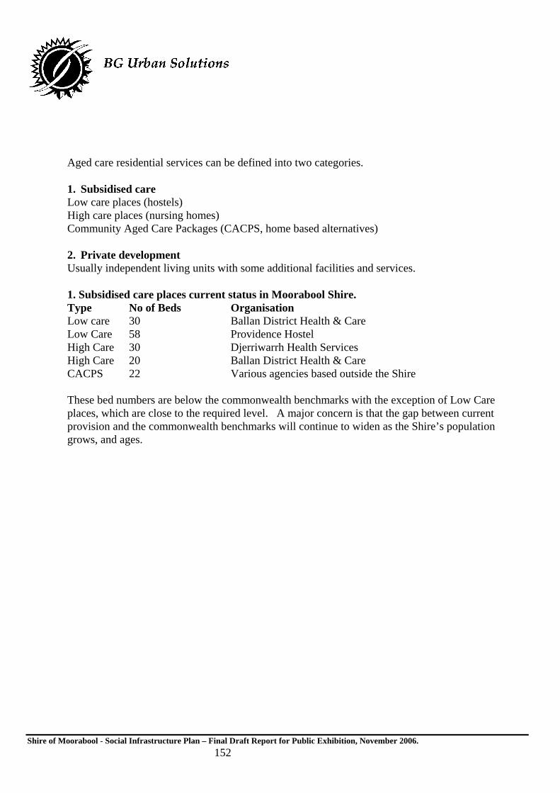
Shire of Moorabool - Social Infrastructure Plan – Final Draft Report for Public Exhibition, November 2006. 152
Aged care residential services can be defined into two categories. 1. Subsidised care Low care places (hostels) High care places (nursing homes) Community Aged Care Packages (CACPS, home based alternatives) 2. Private development Usually independent living units with some additional facilities and services. 1. Subsidised care places current status in Moorabool Shire. Type No of Beds Organisation Low care 30 Ballan District Health & Care Low Care 58 Providence Hostel High Care 30 Djerriwarrh Health Services High Care 20 Ballan District Health & Care CACPS 22 Various agencies based outside the Shire These bed numbers are below the commonwealth benchmarks with the exception of Low Care places, which are close to the required level. A major concern is that the gap between current provision and the commonwealth benchmarks will continue to widen as the Shire’s population grows, and ages.

Shire of Moorabool - Social Infrastructure Plan – Final Draft Report for Public Exhibition, November 2006. 153
If Moorabool does not attract additional aged care residential places, the gap between current provision and beds required according to commonwealth benchmarks will widen. The direct result will be that older residents requiring residential care will need to relocate to either Ballarat or Melbourne which is contrary to current policy which states that older people should be supported to live in their own communities. 2. Private aged care current status in Moorabool Shire.
There are no private “Retirement Village” type unit developments in Moorabool Shire although this is set to change. Recent representations to the planning section indicate that three separate unit developments are being considered in Bacchus Marsh. These developments are to be encouraged because supply and demand is market driven and requires no outlay by Council. Private developments also provide local people with choice. Key considerations to be addressed in the planning approval phase are: Proximity to services, e.g. shopping, transport. Residential design and aspect. Communal facilities. Support services, e.g. emergency call buttons, after hours arrangements. Disability access issues, compliance with standards. Potential impact on Council HACC services.
Aged Care Residential need projections
0
50
100
150
200
250
NH Hostel CACPS
Care type
No
of
pla
ces
Current
2001 ratio
2005 ratio
2010 ratio
2015 ratio
2020 ratio

Shire of Moorabool - Social Infrastructure Plan – Final Draft Report for Public Exhibition, November 2006. 154
Proposal The commonwealth Department of Health and Ageing has responsibility for planning and funding aged care residential places. A new round of places will be advertised by the commonwealth in August 2004 and will make available 11,780 places nationally. A commonwealth report entitled “2004 Aged Care Approvals Round, Regional Distribution of Places” indicates the following places will be allocated to the Grampians Region. Residential Places 75 Community Aged Care Packages 30 High Care CACPS 10 Moorabool has claim to a share of this allocation because of its low bed ratio status within the Grampians Region. The commonwealth is also targeting “Improving access to people living in rural and remote areas” as a key issue for consideration, which will enhance Moorabool’s claim for more resources. A key concern is that Moorabool may again “fall between the cracks” and the resources will be allocated elsewhere in the region. It is proposed that Moorabool Shire Council hosts a workshop of key service providers to develop partnerships and strategies in order to attract new aged care residential places to the LGA.
Policy Implications While Council has no direct role in residential care provision, it does have an interest in ensuring new places are allocated to Moorabool so older residents requiring this level of care can be accommodated in their own communities. Moorabool’s Council Plan clearly articulates the Council’s role as an advocate stating, “In partnership with key stakeholders in government and the community, Council will provide a broad level of support through direct service provision, community development and advocacy for the health and wellbeing of our diverse communities. Financial Implications There are no financial implications associated with the recommendations in this report. Communications Strategy Council considers issuing a press release on the need for aged care residential services in Moorabool and the role it will take as an advocate. Conclusion According to commonwealth planning ratios, Moorabool Shire has the lowest level of aged care residential provision per capita in the Grampians Region, (with the exception of Golden Plains Shire). Current bed numbers are below the commonwealth benchmarks and the gap between current provision and these benchmarks will continue to widen as the shire’s population grows, and ages. The commonwealth will advertise a new round of aged care residential places in August 2004 giving

Shire of Moorabool - Social Infrastructure Plan – Final Draft Report for Public Exhibition, November 2006. 155
key stakeholders an opportunity to bid for additional places. This funding round represents an important opportunity for Moorabool Shire Council to advocate and provide leadership by bringing together key stakeholders to develop partnerships and strategies in order to attract new aged care residential places to the LGA.
Recommendation Council hosts an “Aged Care Residential Services Forum” to form a partnership with key stakeholders to develop strategies to address the requirements of Aged Care Places funding round to be advertised in August. Disability & Aged Services Division Moorabool Shire Council July 2005.

Shire of Moorabool - Social Infrastructure Plan – Final Draft Report for Public Exhibition, November 2006. 156
Appendix 3: Moorabool Shire Council - Integrated Development Assessment Group (IDAG)
Terms of Reference
Purposes The purposes of the Integrated Development Assessment Group (IDAG) are to:
Provide a holistic & strategic response to complex multi-disciplinary issues particularly affecting the broader fields of land & infrastructure development & community services
Provide an agreed & timely response to determinations concerning complex land use & development approvals
Identify barriers to effective organisational performance in land & infrastructure development & assess appropriate measures to overcome them
Provide an effective forum for inter-organisational learning and information sharing
Monitor inter-directorate liaisons and protocols to ensure:
o all statutory obligations continue to be met
o a co-operative work environment is encouraged
o organisational skills are optimised
o a consistent level of service is delivered
o continuous improvement is the norm
o working procedures are appropriately documented. Matters for Consideration Matters for consideration by IDAG will comprise:
Town Planning Approvals Subdivisional Certifications & Statements of Compliance Strategic Planning Issues & Processes Economic Development Proposals Environmental Assessments & Initiatives Community Planning & Development Infrastructure and Assets Initiatives
IDAG will consider matters broadly relevant to the Shire Development, Infrastructure and Human Services Directorates and support the resolution of key issues in these areas as referred to it by the Core Membership. The CEO &/or the Management Executive Group (MEG) will also have the opportunity to refer matters to IDAG, through the current Chairperson.

Shire of Moorabool - Social Infrastructure Plan – Final Draft Report for Public Exhibition, November 2006. 157
IDAG will consider matters which have both a short & long term consequence & an operational or strategic policy focus. IDAG Operational Guidelines Chair - a Chairperson of IDAG will be appointed at the first meeting & thereafter on a quarterly basis Minutes & Agendas - minutes & agendas will be prepared & distributed for all meetings of IDAG Participation/Core Membership - the Core Membership of IDAG will comprise the following officers: Manager Aged & Disability Manager Planning & Building Manager Strategic & Sustainable Development Manager Projects Manager Community Development Manager Assets Manager Environmental Health In the event that a core member cannot attend a meeting of IDAG a proxy must be nominated and the proxy must attend. Co-opted Members - participants of IDAG will be drawn into each meeting as required from relevant Directorates & will comprise (inter alia) the following officers: Co-ordinator Statutory Planning Strategic and Social Planning Co-ordinator Business Development Officer Environmental Health Officer Environment Policy Officer Plantations Officer Compliance Co-ordinator Recreation Officer Parks and Gardens Co-ordinator Other officers might be deemed appropriate as determined by IDAG on a case by case basis.

Shire of Moorabool - Social Infrastructure Plan – Final Draft Report for Public Exhibition, November 2006. 158
Meeting Attendance Invitees must advise the chair of any non attendance by way of email at least 2 business days before an IDAG meeting. Those unable to attend must nominate a proxy to attend in their place. If this is not possible an official explanation of non attendance must be provided by the Chair. Extent of Authority - IDAG will provide recommendations to the CEO/Directors on any matter under consideration which is broadly in compliance with this Terms of Reference - IDAG will provide recommendations to the Director Shire Development/Manager Planning on specific development approvals in Moorabool Shire - IDAG will have the power to co-opt participation of relevant Members in order to achieve stated IDAG purposes - any dispute in relation to the capacity of IDAG to perform its functions as outlined in this Terms of Reference will be resolved by the CEO Effect of Decisions - determinations of IDAG will take the form of recommendations made to each Directorate where primary responsibility for an action lies, or, in some cases to the Management Executive Group (MEG) Admin Support - IDAG will be provided with adequate administrative support by each Directorate on a revolving basis Meeting Frequency - meetings will be convened weekly or fortnightly as determined by the first meeting of IDAG & continuing frequency will be reviewed on a regular basis - the length of meetings will not exceed 2 hours Reporting Process - the minutes of each meeting (containing relevant recommendations) will be directed to each Directorate & to MEG Review of Operations - a quarterly progress report on operations will be prepared, signed off by the current Chairperson & submitted to MEG for consideration.
IDAG Sunset Provision - the performance of IDAG will be reviewed every 12 months & IDAG will only be extended by resolution of MEG.

Shire of Moorabool - Social Infrastructure Plan – Final Draft Report for Public Exhibition, November 2006. 159
Appendix 4 Birth Notification Data: Shire of Moorabool 1994/5 – 2004/5
Year
Total Children enrolled in MCH
Birth Rate
0 to 1 year
1 to 2 years
2 to 3 years
3 to 4 years
4 to 5 years
5 to 6 years
2004/05 1851 299 265 287 325 290 325 359
2003/04 1920 298 282 319 284 330 354 351
2002/03 1941 333 317 271 320 341 344 348
2001/02 1946 290 278 316 328 339 351 334
2000/01 1962 319 299 323 324 340 327 349
1999/00 2017 329 298 313 349 329 379 349
1998/99 2006 354 300 333 317 368 339 349
1997/98 2151 344 307 316 363 348 347 470
1996/97 2073 333 291 364 347 3347 370 354
1995/96 2141 385 353 344 345 367 349 383
1994/95 2067 369 335 341 359 348 358 326
Source: Unpublished Data, Shire of Moorabool 2006.