shifting land use patterns in andhra pradesh:...
TRANSCRIPT

Shifting Land Use Patterns in Andhra
Pradesh: Implications for Agriculture
and Food Security
S. Seethalakshmi
May 2010
Center for Sustainable Agriculture (CSA)
Hyderabad, Andhra Pradesh

2
Contents Page No’s
Acknowledgements 3
Abbreviations 4
Summary of Key Observations 5-11
1. Introduction and Study Objectives 12-13
2. Study Methodology 13-14
3. Shifting Land Use Patterns and Agriculture in
Andhra Pradesh: An Overview of Key Concerns
and Issues 15-34
4. Understanding Changing Dimensions of Land Use on
Ground: Findings from Study Districts 35-72
5. Strategies to Address Farm Land Diversion 73-75
6. Conclusion 76
Bibliography 77-78
3
Acknowledgements
I would like to firstly acknowledge the Center for Sustainable Agriculture (CSA) and
thank Dr. Ramanjaneyulu for approaching me to undertake this study and thereby
providing me an opportunity to collaborate with them. I would also like to acknowledge
the support of Mr. Rajasekhar at CSA during this study.
This study would not have been possible without the support of all the field level
organizations, individual activists and farmers in the study districts who shared their
valuable insights and experiences on the subject during the course of this study. I would
like to acknowledge all their support in providing logistical support related to travel/field
visits, stay, coordination and sparing their precious time that made the field research
possible. My sincere thanks are due to Mr. Murali and Mr. Sekhar in Kurnool district,
Mr. Venkat Naidu, of CSA, Mr. Ismail from Sadhana and all the Women leaders of the
Sadhana MACS Society in Parawada, Mr.Suribabu and Mr. Allu Ganesh of RYDO in
Vishakapatnam district. I would like to sincerely acknowledge the support of Mr.
Prakash, ARTIC and all his team of volunteers in Kothuru Mandal, Mr. Appalanaidu in
Ponduru mandal, Mr.Sanjeev Rao of Velugu Association, Kothuru, Mr.A. Suryanarayana
Raju and Mr.Jagadeeshwara Rao of Samaikhya, Mr.G.Yendiah of Adivasi Vikas
Parishad, Meliaputty mandal, Mr.Balram Naidu of Kranthi Social Service Society in
Vangara mandal, Mr. Sanyasi Rao, ARTS, in Srikakulam district. I thank the district CPI
(M) activist, Mr. Ravi and Mr. P. Ravi, Raviriayala village, Maheswaram Mandal, HRF
member, Mr. Balaraju and Mr. Kodanad Reddy, ex-MLC, of Ranga Reddy district. My
sincere thanks to Mr. Shankar of DBF, Mr. R. Satyanarayan, ex-MLC and TRS General
Secretary, Sangareddy mandal, Mr. Shivaramakrishna, Staff reporter, Eenaadu, Sanga
Reddy mandal Mr.Narasimha, Mr. Sattiah, Mr. Narsing Rao, Mr. Srisailam of the
Toopran Industrial Park Bhu Nirvasitula Sangam, Toopran mandal in Medak district.
I would also like to convey my thanks to all the officials and staff of various government
departments such as the Office of the Chief Planning Officer (CPO), Department of
Agriculture and Horticulture, Registration and Stamps, Revenue Department, Irrigation
Department, office of the Joint Collector, Legal Protection (Encroachment Clearance),
Vigilance and Enforcement etc in all the study districts who shared their insights,
experiences and available data related to this study.
My sincere thanks to all those who participated in the initial discussions and shared their
feedback on the concept note and study methodology, before this study was initiated –Dr.
Vamsi Vakulabaranam, Dr. Purendra Prasad from the University of Hyderabad, Mr.
Ratnam (Journalist and Activist), Mr. Prasad (AP Rythu Coolie Sangham), Mr. Jangiah,
Mr. Rajasekhar, Mr. Dharmender, Mr. Rajasekhar and Dr. Ramanjenuyulu of CSA.
4
Abbreviations
APERP – Andhra Pradesh Economic Reforms Package
APIIC – Andhra Pradesh Industrial Infrastructure Corporation
APHB – Andhra Pradesh Housing Board
BOA – Board of Approval
CF- Current Fallows
CRZ – Coastal regulation Zone
CII – Confederation of Indian Industry
DILL – Deccan Infrastructure and Land Holdings Limited
DWMA- District Watershed Management Agency
DES – Directorate of Economics and Statistics
GSA – Gross Sown Area
GSDP – Gross State Domestic Product
GOAP – Government of Andhra Pradesh
GOI – Government of India
GDP – Gross Domestic Product
GHMC – Greater Hyderabad Municipal Corporation
HUDA – Hyderabad Urban Development Agency
HPCL – Hindustan Petroleum Corporation Limited
IAP – International Airport Project
ITDA – Integrated Tribal Development Agency
IKP – Indira Kanthi Patham
IFAD – International Fund for Agricultural Development
LNA- Land Put to Non-Agricultural Purposes
MOU – Memorandum of Understanding
MORD – Ministry of Rural Development
NSA – Net Sown Area
NTPC – National Thermal Power Corporation
NPM – Non-Pesticidal Management
NALA – Assessment of Non-Agricultural Lands Act, 1963
NCAS – National Center for Advocacy Studies
NABARD – National Bank for Agriculture and Rural Development
NREGS – National Rural Employment Guarantee Scheme
ORR – Outer Ring Road Project
PESA – Panchayat Raj (Extension to Scheduled Areas) Act 1996
PCPIR – Petroleum, Chemicals and Petro-Chemical Investment Region
PD – Project Displaced
PAP – Project Affected Persons
RDO – Revenue Divisional Officer
SEZs – Special Economic Zones
SLUB – State Land Use Board
TDP – Telugu Desam Party
VUDA – Vishakapatnam Urban Development Agency
VANPIC – Vadarevu and Nizampatnam Port and Industrial Corridor
VRO – Village Revenue Officer

5
Summary of Key Observations
A research study was undertaken in Andhra Pradesh to understand the nature and extent
of diversion of agricultural land to other purposes and the impact of this shift on
agriculture and food production. A related aim of the study was to explore policy
recommendations and strategies using the study outcomes as a basis. For a more detailed
study, five sample districts were selected namely Ranga Reddy and Medak district in
Telangana region, Srikakulam and Vishakapatnam in Coastal Andhra and Kurnool
district in the Rayalaseema region. What follows is a summary of key observations from
the study.
1. At the State Level, analysis of data on land put to non-agricultural purposes for
the period 1990-91 to 2007-08 indicates a 14.3% increase from 23.06 lakh
hectares to 26.37 lakh hectares during the 18-year period. In other words, this
means that an extent of 3.31 lakh hectares or 8.27 lakh acres has been diverted to
non-agricultural purposes during this 18-year period. However, even these figures
may not be entirely accurate and underestimates to a large extent since many land
transactions, especially for real estate purposes are not officially recorded and
therefore do not form part of the above estimates. There is also paucity of data
related to diversion of government lands to non-agricultural purposes, which are
cultivated by a large number of the poor in the State.
2. A conventional estimate from this study as well as a review of other similar field
studies in the State indicate that over 20-25 lakh acres of farm land may have
gone out of cultivation during the last 18 years. There are also indications that
land loss has been more rapid in the last 8-10 year period, with diversion of vast
extents of land being diverted to the establishment of Special Economic Zones
(SEZs), Ports, Industrial Corridors, Airport projects, Infrastructure and irrigation
projects under Jalayagnam programme etc.
3. Intra-State analysis for various regions again reveals interesting findings. In the
coastal Andhra region, data indicates that land put to non-agricultural purposes
has been highest in Srikalulam district with a 33% increase during the above
period, followed by East Godavari (25%) and Vishakapatnam (20%) in the North
Coastal Andhra region. In the South Coastal Andhra region, Krishna district
shows the highest extent of land put to non-agricultural purposes with a 27%
increase over the 18-year period followed by Nellore district (25%).
4. In the Rayalaseema region, kurnool district shows the highest area put to non-
agricultural purposes with a 37% increase during the period 1990-91 to 2007-08.
In the Telangana region, Ranga Reddy district has the highest area put to non-
agricultural purposes (31%), followed by Karimnagar and Nalgonda (both 27%)
Nizamabad (18%) and Medak (15%) district for the above period.
5. Analysis of data related to land put to non-agricultural purposes (LNA) and
Current Fallows (CF) for the period 1990-91 and 2007-08 in the State reveals

6
that the extent of area under both categories has been steadily increasing over
time. However, land under permanent pastures has been coming down from 8.42
lakh hectares in 1990-91 to 5.71 lakh hectares in 2007-08 (-32%). Net Sown Area
(NSA) also indicates a negative or declining growth rate of -2.4% for the period
while there has been only a marginal increase of 2.8% in the Total Cropped Area.
The area sowed more than once reveals a growth rate of 29% for the 18-year
period at the State level indicating expansion in irrigation infrastructure, private
investments in bore wells etc during the period. Again, only some parts of the
State account for this growth.
6. Analysis of official data on LNA, CF and land area under principal crops such as
Paddy, Jowar, Maize and Red Gram in the five study districts again reveals
interesting findings. Analysis of data related to Ranga Reddy district reveals that
there has been a significant increase in LNA from 77,942 hectares in 1990-01 to
1.02 lakh hectares in 2007-08 or 13.5% of the total geographical area of the
district, while land under CF has almost doubled from 1.16 lakh hectares to 2.18
lakh hectares accounting for 29.10% of total area during this period. Land under
Paddy and Jowar cultivation has witnessed a steep fall during this period
registering a decline of close to 50% in paddy and over 70% in Jowar area. Area
under cultivation of Redgram and Maize has remained more or less steady during
the period.
7. Ranga Reddy district has perhaps witnessed the diversion of farm land at a more
rapid pace than any other district in the past 10 years. Development of
infrastructure projects like International Airport, outer ring road, development of
IT parks, SEZs and real estate are the major factors accounting for diversion of
farm land. Land diversion has been highest in East Division comprising of
Maheswaram, Kandukur, Shamashabad, Saroornagar etc and Sherlingampally in
Chevella, which are closer to Hyderabad City as compared to the Vikarabad
division. While there are no accurate estimates available, discussions with various
officials indicate that close to 2 lakh acres of farm land may have gone out in the
last 8 years. Diversion of farm land has meant a steep fall in cultivation of
vegetables, Paddy, Jowar etc in the district. Large extents of land diverted to real
estate ventures, which are yet to take off have not been converted under the
Agricultural Lands Conversion to non-agricultural purposes Act 2006. This also
perhaps accounts for the high percentage of fallow lands in the district, which has
doubled during the years 1990-2008.
8. In Medak district, land put to non-agricultural purposes shows a marginal decline
from 60,000 hectares to 55, 947 hectares during the 18-year period. Land under
current fallows was the highest during the year 1990-91 (1.83 lakhs), came down
marginally and then increased during the subsequent period to stand at 1.92 lakh
hectares (19.8% of total area) during 2007-08. Paddy cultivation registered a fall
between the years 1990 to 1995 and then peaked during the year 1999-00 and then
again fell during the period 2007-08. Cultivation of Jowar registered a steep fall
from 1990-91 to 2007-08 (-60%). Red Gram cultivation has almost remained

7
steady in the district, indicating a marginal increase during the period 2007-08.
Maize cultivation has picked up steadily over the last 18 year period.
9. Field studies in Medak district shows that the two major purposes for which
agricultural land is being diverted are real estate and industries. Real estate is high
in 11 mandals of this district which fall in the Greater Hyderabad Municipal
Corporation limits (GHMC) like Ramachandrapuram, Patancheru, Jinnaram,
Mulug, Wargal, Sangareddy, Toopran, Narsapur, Kondapur etc. About 40% of the
farm land in each of these mandals has been converted to real estate. According to
the estimates by the Vigilance Department which carried out a random study in 5-
6 mandals, over Rs. 75 crores has been foregone as revenue, with many of the real
estate developers failing to pay conversion fee under Agricultural Land
(Conversion to Non-Agricultural Purposes ) Act 2006 or NALA Act. Most of the
land being converted is patta lands and some pockets of these lands are
assignment lands. There is no record since most of the agreements are informal
and done under general purpose agreements. According to the Revenue
Departments’ estimates, around 2 lakh acres of farm land in the district has been
left idle or fallow. Jowar, Paddy, Maize and Sugar Cane are some of the major
crops in the district but except Maize, the area under other crops has been coming
down over time. Land conversion is also happening through cropping changes
like shift to horticulture crops like Mango, Guava etc in the district.
10. Data from Kurnool district shows that land under CF and LNA have increased
during the 18-year period. LNA increased from 1 lakh hectares to 1.38 lakh
hectares while land under CF increased from 1.05 lakh hectares to 1.29 lakh
hectares during the period. Area under paddy remained more or less steady during
the 10 years 1990-2000 but registered a fall during the years 2004-05 and then
increased again to 93,000 hectares during the years 2007-08. Area under Bengal
Gram increased exponentially from 20,000 hectares in 1990 to 2.17 lakh hectares
by 2007-08. Area under Red Gram increased marginally while area under Jowar
cultivation fell drastically from 1.62 lakh hectares to 73,236 hectares during the
above period.
11. Discussions with various government officials, activists and farmers in Kurnool
district reveal that the three most important causes for diversion include real
estate, educational institutions like engineering, medical colleges and private
schools, construction of several warehouses for seed storage followed by land
diversion for infrastructure and irrigation purposes. Diversion of agricultural land
has been higher in Kurnool and Kallur revenue Divisions. In several villages in
these mandals only around 20% of agricultural land is remaining today. Field
visits to Joharapuram, Dinnedevarapaadu in Kurnool mandal and Pandipaadu and
Peddapaadu in Kallur mandal reflect the above clearly. Officials share that the
Net Sown Area has been steadily coming down, while there have also been major
shifts in cropping patterns in the district.

8
12. Analysis of data from Srikakulam district reveals that land put to non-agricultural
purposes increased from 74,453 hectares to 99,000 hectares (33%) during the 18-
year period. Land under current fallows also increased significantly from 22,000
hectares in 1990 to 56,845 during 2004-05 and then fell steeply to 10,000 hectares
during the year 2007-08. The area under paddy cultivation registered a marginal
decrease from 2.14 lakh hectares to 1.97 lakh hectares during the 18-year period
while area under Ragi cultivation fell steeply from over 18,000 hectares to around
3,000 hectares in the same period. Area under both green gram and black gram
rose significantly during this period.
13. Discussions with various government officials and activists in Srikakulam district
showed that the major causes of land diversion in the district are irrigation,
infrastructure projects such as Thermal power plants, and real estate to some
extent in recent years. Field visits to various parts of the district revealed various
dimensions of land conversion and diversion taking place in the district. In the
tribal areas of the district land under podu cultivation which was under food crops
had been converted into cashew and other plantation crops during the 1980’s by
government agencies like the ITDA, supported by funding from IFAD. In both
tribal and sub-plan areas in the last 5-8 years, land which was earlier under food
crops like millets and cereals is being converted into plantation crops through land
leasing to migrant farmers from other districts who are coming here with capital
to encourage plantations. Most of those leasing land are from Krishna, Guntur,
East Godavari and West Godavari districts. Land is leased out through formal and
informal contracts for raising palm oil, cashew, banana, casurina etc. This is
happening in Seethampeta, Hiremandalam, Kothuru, Bhamini, Ponduru,
Veeraghattam, Buruji mandals. Land leasing is also done for plantation by
companies like J.K. Paper Mills, Andhra Paper Mills, Rajamundry and Jeypore
Paper Mills, Rayagada, Orissa. According to a study by ActionAid and Laya on
displacement related issues, it is estimated that around 2 lakh acres of land in
Srikakulam, Vishakapatnam and Vizianagaram districts has been diverted to
mining, granite and stone quarrying, industries, infrastructure projects in the last
10 years.
14. Data from Vishakapatnam shows that both LNA and area under CF have
increased during the 18-year period. The extent of area put to LNA increased
from 85,944 hectares to 1.03 lakh hectares during this period while land under CF
increased from 12,000 hectares to 63,000 hectares. Land under paddy cultivation
increased marginally from 1.08 lakh hectares to 1.18 lakh hectares during the
decade 1990-00 and fell to 95,747 hectares in 2007-08. Cultivation of Ragi area
fell from 38,924 hectares to 29,423 hectares during the period whereas area under
Bajra cultivation fell drastically from 41,000 hectares to 8000 hectares.
Cultivation of area under Jowar remained more or less constant during this period.
15. Findings from Vishakapatnam district reveal that of the three main revenue
divisions in the district- Paderu, Narasipatnam and Vishakapatnam, diversion of
agricultural lands has been highest in Vishakapatnam division in the last 10 years.

9
Land diversion has been mostly to industries and real estate activities and this
diversion has been higher in 8-9 mandals of the district. These include
Vishakapatnam Urban, Anandapuram, Bhimili, Paravada, Pendurthi, Sabbavaram,
Peddagantyada and Anakapalli in the Vishakapatnam revenue division. In the
Narsipatnam revenue division, the diversion is higher in Achutapuram, Rambilli,
Maakavaaripalem, Payakaraopeta and Nakkapalli mandals where land has been
diverted to several industries and Special Economic Zones (SEZs) in the last 10
years. All these mandals are located on the National Highway-5 and are close to
the sea coast. The extent of land diversion to SEZs alone is around 20,000 acres.
However, the development of SEZs only form part of a larger Petroleum,
Chemicals and Petro-chemical Investment Region (PCPIR) proposed to be
developed in an area of 604 square kilometers, involving 1.49 lakh acres of land.
The pace of farm land diversion has been faster since the early 2000’s. The period
2006-08 was a period of boom in real estate. However, large extents of land
diverted for real estate ventures have not taken off and left fallow. Estimates
related to applications for conversion of agricultural land as per the 2006 Act
from the RDO office, Vishakapatnam shows that the figures are underestimates.
Paddy, Ragi, Bajra and sugar cane are the major crops in the district and are
mostly rainfed. The increase in land value due to industrialization and real estate
has also influenced shifts in cropping patterns to horticulture crops and plantation
crops like cashew, casurina etc in the last 10 years in the district.
16. A review of State policies in the last two decades reveals that during the 1990-
2000 period globalization led policies involving withdrawal of support to
agriculture in the form of cut back in subsidies on seeds, water, power and other
critical inputs led to the destruction of the agricultural sector in many ways. More
importantly, this period also saw important changes in the functioning of the
revenue department with a dilution of its core functions and more development
related functions being added on. The vision 2020 policy document clearly
reflected the government policy with regard to agriculture stating the need to
reduce the percentage of people dependent on this sector for their livelihoods.
With the objective of achieving faster growth rate in the State, several
infrastructure projects such as expansion of highways, roads, international airport
in Hyderabad, and policy guidelines for establishment of Special Economic Zones
(SEZs) in the State were introduced by the TDP Government during the period
2000-03. All these projects involved large scale acquisition of farm lands in
various parts of the State.
17. Analysis of State policies in the last 8 years shows that along with the pursuance
of earlier policies by the subsequent Congress Government, several key policy
decisions made especially in relation to land have facilitated and perhaps
accelerated the diversion of farm land in many ways. The introduction of the
APSEZ bill by the Congress government following the enactment of the SEZ Act
in 2005, replacement of the earlier A.P Non-Agricultural Lands Assessment Act
(NALA) 1963 with the Agricultural lands (Conversion to non-agricultural
Purposes) Act 2006, critical amendment to the original Assignment lands

10
(Prevention of Transfer) Act 1977 through the 8 of 2007, amendments to the
Urban and Agricultural lands Ceiling Act, etc have had important implications on
agricultural land. Further, the expansion of the powers of Urban Development
bodies like HUDA and VUDA has also led to these institutions being involved in
sale of farm lands in the peripheries of cities to raise money through auctions.
State owned Corporations like the APIIC have also been playing an important role
in the development and facilitation of SEZs as well as creating land banks and
developing the same for industrial purposes all over the State.
18. In the year 2002, the GOAP passed the A.P. Water, Land and Trees Act 2002, and
Rules 2002, to promote water conservation and tree cover and to regulate the
exploitation and use of ground and surface water for protection and conservation
of water sources and land related matters connected therewith. A significant
intervention aimed at addressing the issue of land was the constitution of the
Koneru Ranga Rao Committee in 2005 to study land issues in the State and come
up with recommendations for the implementation of land reforms. But the
implementation of the Committee’s recommendations has been tardy and
ineffective. The Congress government also claims to have distributed of over 7
lakh acres of government land to the landless poor in the last 6 years in various
phases. Field visits to the five study districts and data collected through
discussions with a cross section of people shows the manner in which the official
policies related to land issues as well as the related impacts on agriculture bear out
on ground.
19. The study findings suggest the need for some urgent policy measures to arrest
diversion of agricultural land in the State such as formulation of a comprehensive
land use policy by the Government, regulating the diversion of farm land by
setting up threshold levels for minimal land diversion, formation of a fully
functional State land Use Board at the earliest, comprehensive land reforms
implementation with appropriate legislation to prevent the alienation of land from
the hands of the poor, reviewing the APSEZ policy and bill and a moratorium on
further diversion of land for SEZs, projects like coastal industrial corridor etc
reviewing the approvals to existing SEZs, implementation of the Koneru Ranga
Committee recommendations at the earliest etc. The study findings clearly points
to the need to address the growing problem of current fallows in various districts
along with the issue of land diversion. Public investments in the form of
irrigation, credit and other infrastructural support are urgently needed to address
the issue of current fallows and bring the land under the same under cultivation.
Strengthening the role of Gram Panchayats and Gram Sabha’s on land related
issues at the village level. Revamping the role and functions of the revenue
department especially to accelerate the process of survey and settlement of
outstanding claims and disputes related to land, updating of land records in
various districts etc.

11
The study is a preliminary attempt to understand the phenomenon of land
diversion and its impact on food production. Not withstanding the limited time
frame and resources for the study as well as paucity of data related to various
dimensions of land diversion, it is hoped that this study will provide a useful
framework and a basis for a more detailed analysis and building of data base in
future on the nature and forms of land diversion in Andhra Pradesh.

12
1. Introduction Agriculture plays a significant role in the Indian economy and the performance of this
sector is vital for inclusive growth of the country. Agriculture not only contributes to the
overall growth of the economy but also provides a vital livelihood base, employment and
food security to the majority of the country’s population. Andhra Pradesh was among the
very few states in the country which went in for the Green Revolution in rice cultivation
in the 1970s. Although its contribution to gross state domestic product (GSDP) is around
one-fourth, agriculture provides employment to nearly 60 per cent of the work force. The
share of agriculture in GSDP and employment are higher in A.P. as compared to all-
India. Average per capita agricultural income in the state was Rs. 3618 while it was Rs.
3360 in all-India at constant (1993-94) prices in the triennium 2002-05 (Andhra Pradesh
Human Development Report, 2007).
However, in the past two decades or so, there have been significant changes in the
structure and performance of the agricultural sector in Andhra Pradesh. So far, various
studies and analysis have focused attention on the growing crisis in agriculture due to the
adverse impacts of liberalization-led policy initiatives in the sector and its dimensions in
the form of withdrawal of subsidies accompanied by high input costs, inadequate
institutional credit and public investments in infrastructure creation, market volatility, etc
leading to high incidence of suicides by farmers in the State. An emerging challenge in
relation to agriculture that has not been adequately researched or analyzed is the
diversion of agricultural land for non-agricultural purposes. These include industries,
establishment of Special Economic Zones (SEZs), development of infrastructure in the
form of highways, expressways, expansion and creation of new airports, ports, thermal
power plants, mining, irrigation and housing projects etc. All these developments appear
to be creating competing priorities and pressures on land availability and use, with often
adverse implications for the farming sector.
There are no official estimates on how much agriculture land has been diverted till date
as has been made clear by the Planning Commission’s July 2006 report of the Working
Group on Land Relations for the11th Five Year Plan. According to the estimates by the
Ministry of Agriculture, between 1990 and 2004, land under non-agricultural use has
gone up by 34 lakh hectares (GOI, 2007). Meanwhile, there is evidence from all across
the country that agricultural land is shrinking. In Andhra Pradesh again there is no
official estimate of the scale of farm land diversion to other purposes. Available study
reports and some media reports indicate that indicate the accelerated pace of farm land
diversion in Andhra Pradesh over the last decade or so.
Available literature also suggest that the large scale diversion of farm land has been
facilitated through relaxing land acquisition procedures and ceiling regulations by various
states, including Andhra Pradesh in the post 1991 period. Apart from diversion of farm
land to non-farm purposes, available evidence from various parts of the State also points
to the increasing conversion of agricultural lands to commercial plantation like timber, oil
palm, or allocation of large tracts of lands for growing biofuels etc. These shifts also
appeared to be increasingly contributing to food insecurity and threatening the
13
livelihoods of farming and livestock rearing communities in many ways. In the absence
of any data and any systematic study on the above processes, there was an urgent need to
undertake an in depth study of the extent, forms and impacts of diversion of farm land
both at the macro and micro levels, and policy process related to the same in order to
reorient both policy directions in the State and practices on ground.
1.1 Study Objectives In the above context, the main objectives of this study were
To understand the nature and extent of diversion of agricultural land for non-
agricultural purposes in the State over the last two decades
To understand the implications of farm land diversion on agriculture and food
production at the State and micro-levels
To use the study outcomes as a basis for coming up with some recommendations
as well as for sharing the findings amongst farmers, labor unions, civil society
organizations etc for building evidence based advocacy processed at various
levels
2. Study Methodology
The study methodology broadly consisted of the following components and steps.
Review of Secondary Literature: As a starting point, the study sought to
understand the nature and patterns of farm land diversion through a review of
existing literature in the form of research reports, media reports etc on the subject
along with official documents and sources such as land utilization data and
cropping data at the State and for various districts for roughly two decades (1990-
2009) which formed the focus of this study. Review of secondary also included
Government Orders, legislations, policies, combined with online search through
relevant websites etc
Secondary Data Collection: Collection of secondary data for the study was
done from the offices of relevant government departments in Hyderabad such as
the Directorate of Economics and Statistics, Revenue Department, University
Libraries etc.
Selection of Sample Districts for Study: Using the analysis from a
review of existing literature on the subject and secondary data as a basis, 5 sample
districts were selected for more detailed field study namely Ranga Reddy and
Medak district in Telangana region, Srikakulam and Vishakapatnam in Coastal
Andhra and Kurnool district in the Rayalaseema region. Some of the key criteria
from secondary data used for selection of these districts for primary field studies
were regional variations in land use shifts, districts where large extent of
agricultural lands have been diverted for various purposes etc
Collection of Primary Data: In all the above 5 districts, attempt was made
to collate data from various sources such as the offices of Chief Planning Officers

14
(CPO) Mandal Revenue Offices, Stamps and Registration Departments, Revenue
Divisional Offices in the districts, Department of Agriculture, Directorate of
Industries etc. This was combined with a cross section of detailed interviews with
activists and local organizations working on the issue as well as discussions with
farmers and local communities to understand their experiences in relation to
diversion of farm land for various projects and related impacts over time.
2.1 Study Methods/Tools
A combination of quantitative and qualitative data collection methods were
adopted for collection of both primary and secondary data such as time series data
on land use and cropping patterns, trend analysis, use of open-ended interviews,
group discussions, compilation of case studies, policy analysis etc to understand
and categorize various processes in relation diversion of agricultural land.
Photo Documentation: Photo Documentation was also undertaken as part of this
study wherever possible/relevant.
Time Frame – The study was carried out over a 5-month period from November
2009 to March 2010.

15
3. Agriculture and Shifting Land Use Patterns in Andhra Pradesh: An
Overview of Key Issues and Concerns
The role of agricultural sector in the Country’s economy is very significant. The green
revolution was aimed at helping the country to achieve self-sufficiency in food grains and
it succeeded in achieving this objective to some extent. But given the problems with the
green revolution technologies, however, the subsequent periods saw the natural resource
base of the major food bowls across the country being severely eroded with production
levels either stagnating or declining for most crops. Research and analysis by many has
shown that the impact of green revolution have been disastrous on many fronts. Evidence
also points to the fact that the overall growth rate in agriculture after 1990 has declined as
compared to 1980s (Economic Survey of India, 2007; Dev, 2004). The stagnation in
agricultural growth that began in the decade and a half period beginning 1980, when the
growth rate hovered around 3%, dropped to a mere 2% for the period 1995-2005; later
this further nosedived to 1.5%. The contribution of agriculture to GDP also fell from 37%
in 1983 to around 19% during 2007-08. Despite this reality, the 11th five year plan
projects an ambitious target of 4% rate of growth in agriculture. The growth in
productivity of most of the important food crops like rice, wheat, coarse cereals and
oilseeds was negative for the period 1996-2004. When the food demand is projected to
touch 240 million tonnes in 2010, production stood at less than 220 tonnes during the
year 2007-08 (Goswami, 2008).
Section-I: Overview of the Status of Agriculture in Andhra Pradesh
In Andhra Pradesh, around 63% of the working population is dependent on agriculture
for their livelihoods. The contribution of the primary sector including agriculture,
horticulture and animal husbandry to the Gross State Domestic Product (GSDP) of
Andhra Pradesh for the year 2007-08 was 22.18%. Agricultural production in the State is
largely dependent on rainfall and seasonal monsoon or rainfall conditions play a major
role in determining the extent of food production or output from agriculture. Around
49.3% of the area in the State is under agriculture, which is higher than the national
average of 40.4%. Of the Gross Sown Area in AP, the Gross Irrigated Area is 46.3%.
A review of land use trends in Andhra Pradesh over the last five to six decades clearly
shows that there is an overall stagnation of cultivable area. An increase in the net sown
area is neither seen as desirable or feasible, as indicated by various plan documents
(Vision 2020, Swarnadhra Pradesh, 2000, GOAP). This is particularly true in the wake of
structural adjustment and reform processes initiated in the State during the mid-nineties,
where the secondary and tertiary or services sector were seen as being more important
engines for the State’s Growth. However, unlike the other two sectors, agriculture is a
land intensive activity and therefore the declining contribution of agriculture in the GSDP
cannot be really indicative of the relative requirement of land for this sector. The adverse
impact of globalization-led policies on agricultural growth pursued by various
governments in the State over the past two decades has been well analyzed in various
writings (Dev, 2004; Reddy, D.N., 2006, Vaidyanathan, 2006).

16
An area that has perhaps not received adequate research or analysis so far is the diversion
of agricultural land in the State for a range of non-agricultural purposes and the impact of
the same on agriculture. The diversion of agricultural land to non-agricultural purposes is
increasingly being justified based on the now well entrenched discourse or argument that
agriculture, especially small-scale farming, is no longer remunerative or viable. There are
also indications that the pace and extent of land diversion has been higher in the last
decade or so. Through an analysis of official data on land use, changes in cropping
patterns, data on land diversion to various projects and a review of official policies that
have impacted these shifts over the last two decades, this section attempts to bring out the
linkages between these variables in order to understand the implications of the same on
agriculture and food production in the State.
1. Classification of Geographical Area in Andhra Pradesh
Crop and land use statistics form the backbone of the Agricultural Statistics System.
Reliable and timely information on crop area, crop production and land use is of great
importance to planners and policy makers for efficient agricultural development and for
taking decisions on production, procurement, storage, public distribution, export, import
and many other related issues. Prior to 1950-51, the land utilization statistics were
available under five categories namely forest, area not available for cultivation, other
uncultivated land excluding current fallows, fallow lands and net sown area. This
classification was found to be insufficient to meet the needs of agricultural planning and
later a more detailed nine-fold classification on land use with standard definitions and
concepts were adopted by the government. These are as follows.
i. Forest – Area under forest includes all lands classified as forests under any
legal enactment dealing with forests, whether State owned or private. The area
of crop raised in the forest and grazing lands or area for grazing within the
forests is also included under the forest area.
ii. Land Put to Non-Agricultural purposes – This includes all lands occupied
by buildings, roads, and railways or under water like river and canals and land
put to uses other than agriculture.
iii. Barren and Unculturable Land – This covers all barren and uncultivable
land like mountains, deserts etc and land includes all such land whether in
isolated blocks or within cultivated holdings.
iv. Permanent Pastures and Other Grazing Lands – This covers all grazing
lands, whether they are permanent pastures and meadows or not. Village
common grazing lands are also included here.
v. Miscellaneous Tree Crops and Groves – This includes land not counted as
net sown area but put to some agricultural use. Lands under casurina trees,
thatching, grass, bamboo bushes and other groves for fuel etc not included
under orchards shall be included in this category.
vi. Culturable Waste – These includes all lands available for cultivation whether
not taken up for cultivation or taken up for cultivation once and left
uncultivated during the current year or last five years in succession.
17
vii. Other Fallow Lands – This includes all lands which were taken up for
cultivation but are temporarily out of cultivation for a period of not less than
one year and not more than five years. The reasons for keeping the land fallow
may be poverty, inadequate supply of water, un remunerative nature of
farming, sitting of canal and rivers etc
viii. Current Fallow – This category comprises cropped areas, which are kept
fallow during the current year such as seeding area which is not cropped again
in the same year may be treated as current fallow
ix. Net Sown Area – This represents the total area sown with crops and orchards
and also includes areas sown more than once in the same year and gross
cropped or total cropped area which is the sum of areas under all crops and
which includes Net Sown Area and Areas Sown more than once.
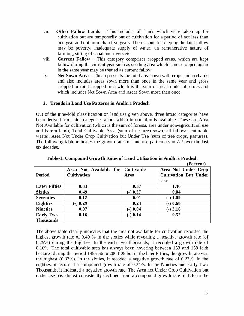
2. Trends in Land Use Patterns in Andhra Pradesh
Out of the nine-fold classification on land use given above, three broad categories have
been derived from nine categories about which information is available. These are Area
Not Available for cultivation (which is the sum of forests, area under non-agricultural use
and barren land), Total Cultivable Area (sum of net area sown, all fallows, cuturable
waste), Area Not Under Crop Cultivation but Under Use (sum of tree crops, pastures).
The following table indicates the growth rates of land use particulars in AP over the last
six decades.
Table-1: Compound Growth Rates of Land Utilisation in Andhra Pradesh
(Percent)
Period
Area Not Available for
Cultivation
Cultivable
Area
Area Not Under Crop
Cultivation But Under
Use
Later Fifties 0.33 0.37 1.46
Sixties 0.49 (-) 0.27 0.04
Seventies 0.12 0.01 (-) 1.09
Eighties (-) 0.29 0.24 (-) 0.68
Nineties 0.07 (-) 0.04 (-) 2.16
Early Two
Thousands
0.16 (-) 0.14 0.52
The above table clearly indicates that the area not available for cultivation recorded the
highest growth rate of 0.49 % in the sixties while revealing a negative growth rate (of
0.29%) during the Eighties. In the early two thousands, it recorded a growth rate of
0.16%. The total cultivable area has always been hovering between 153 and 159 lakh
hectares during the period 1955-56 to 2004-05 but in the later Fifties, the growth rate was
the highest (0.37%). In the sixties, it recoded a negative growth rate of 0.27%. In the
eighties, it recorded a compound growth rate of 0.24%. In the Nineties and Early Two
Thousands, it indicated a negative growth rate. The Area not Under Crop Cultivation but
under use has almost consistently declined from a compound growth rate of 1.46 in the

18
late fifties, showing a declining trend from the seventies through the nineties and then
showing a growth rate of 0.52 % again in the early two thousands.
Table-2
Decadal Variation in Shares of Various Land Use Categories to Reporting Area
(% of RA)
Year Area Not Available
for Cultivation
Pastures & Tree
Crops
Total Cultivable Land
1955-1956 36.85 5.29 57.86
1965-1966 37.15 5.39 57.46
1975-1976 38.90 4.52 56.58
1985-1986 37.73 4.17 58.10
1995-1996 39.28 3.68 57.04
2004-2005 39.69 3.48 56.83
From the above table, it can be inferred that the share of land not available for cultivation
has increased almost by 3 percentage points over the five decade period from 36.85% to
39.69%. On the other hand, the land available for cultivation is almost hovering around
57 to 58 percent. The share of pastures and tree crops has been witnessing a steady
increase.
3. Changes in Cropping Pattern and Cropping Intensity
An analysis of food production in Andhra Pradesh with regard to principal crops reveals
important shifts in the last five decades or so. Rice is a major crop in the State followed
by millets, pulses and non –food crops like oilseeds, Cotton, Tobacco, Jute, Dyes, fodder
crops and green manure crops.The gross cropped area of Andhra Pradesh had increased
from 123.02 lakh hectares in 1955-56 to 125.18 lakh hectares in 2004-05. But this shift
indicates a major change from food crops to non-food crops. It is evident from data that
the total area under cereals and millets fell from 76.07 lakh hectares in 1955-56 lakh
hectares to 44.63 lakh hectares in 2004-05. In comparison, the area under non-food crops
increased from 28.32 lakh hectares to 46.35 lakh hectares during the above period. The
crops that caused this important shift are cotton, Groundnut and sunflower. Time series
data related to area under principal crops in the State indicates shifts in cultivation area
more clearly over the period 1990-2008.
Area under Principal Food and Non-Food Crops (in Lakh Hectares) for 1990-2008
Crop 1990-91 1994-95 1999-00 2004-05 2007-08
Rice 4035884 3637558 4014248 3086202 3984000
Jowar 1190105 944398 735929 500000 331000
Bajra 231362 137330 116603 94000 74000
Green Gram 493380 500725 458689 454000 438000
Black Gram 539780 464698 460851 427000 503000
Red Gram 345692 298944 432159 480000 463000
Cotton 655388 844529 1045704 1178000 1134000
Groundnuts 2393863 2176298 1795117 1841000 1795000
Sunflower 162486 402646 277803 476000 426000

19
Source: Compendium of Area and Land Use Statistics of Andhra Pradesh
1955-56 to 2004-05, Directorate of Economics and Statistics
An Outline of Agricultural Situation in Andhra Pradesh 2007-08, DES, Hyderabad
The above data shows that rice production fell from 40.35 lakh hectares in 1990-91 to
39.84 in 2007-08. Cultivation of Jowar areas fell steeply from 11.90 lakh hectares to 3.31
lakh hectares and Bajra from 2.31 lakh hectares to 74,000 hectares during the period.
Excepting Red Gram, cultivation of area under pulses also reflects a decrease during this
period. Cultivation of area under Cotton almost doubled during this period from 6.5 lakh
hectares to 11.3 lakh hectares. Similarly, area under sunflower cultivation increased from
1.62 lakh hectares to 4.26 lakh hectares whereas area under groundnut cultivation
decreased from 2.39 lakh hectares to 1.79 lakh hectares during this 18-year period.
The primary source of land increase is expected to come from increase in cropping
intensity. Cropping intensity is the ratio of gross area sown to net area sown and is one of
the indices for assessing the efficiency of agricultural sector. It can be observed from the
data that the cropping intensity in the State which was 1.09 during 1955-56 increased to
1.24 in 1988-89 but dwindled to 1.21 in the year 2004-05 and again increased slightly to
1.26 in 2007-08.While availability of water, especially from man-made sources is an
important factor for determining cropping intensity, this fact along with the above data
also indicates that there is every scope for increasing food production through policies
and programmes.
4. Irrigation Statistics
The main sources of irrigation in Andhra Pradesh are canals, Tanks, Tube Wells and Dug
Wells. Irrigation Statistics comprise mainly data on area irrigated by different sources
and the area under different crops irrigated. Two types of irrigated area can be
distinguished – Net Area Irrigated, which is the area irrigated during the agricultural year
counting the area only once even if two or more crops are irrigated during different
seasons on the same land and Gross Area Irrigated, which is the total area irrigated under
various crops by various sources during the year, counting the area irrigated under more
than one crop during the same year.
The Net area irrigated was 27.47 lakh hectares in 1955-56 and it increased to 46.44 lakh
hectares in 2007-08. Similarly, the gross area irrigated which was 31.99 lakh hectares in
1955-56 increased to 62.85 lakh hectares in 2007-08. Irrigation intensity i.e. the ratio of
gross irrigated area to net irrigated area was 1.16 in 1955-56 increased to 1.35 in 2007-
08.Disaggregation of data related to Net area irrigated by various sources again indicates
important shifts. The area irrigated by tanks decreased significantly from 10.67 lakh
hectares in 1955-56 to 4.77 lakh hectares by 2004-05. The area irrigated by canals during
the same period increased from 12.91 lakh hectares to 13.45 lakh hectares. The area
irrigated by tube wells, which began during 1961-62 rose exponentially from 20,248
hectares to 12.54 lakh hectares by 2004-05.

20
Section-II: Understanding Patterns of Land Use Shifts in Andhra Pradesh
Land is a finite resource and put to many competing uses. It comprises soils, minerals,
water and biota. In India land is a source of livelihood for over 70 % of the population
through agriculture and related activities. Population growth and the consequent demand
for land, water and biological resources has put tremendous pressure on land. In recent
times, land-use change through industrialization, urban growth, development of
transportation networks, creation of infrastructure etc has accelerated the process of land
diversion from agriculture to various other purposes as well as land degradation in a big
way. The Prime Minister, Dr. Manmohan Singh in his address to the CII Summit in 2007 said
that, “Agriculture has become unviable on account of the small land holdings of Indian
farmers. National interest of overall growth and development demands creation of jobs in
Industrial sector. Industrial Progress is vital to the progress of the nation”, (India Vision
2020 Challenges Ahead, March 26, 2007, New Delhi). In March 2010, the Central
Government said that the country’s cultivable land has marginally fallen in 2005-06,
mainly due to diversion of farm land for non-agricultural purposes. Total cultivable
land has declined to 182.57 million hectares in 2005-06 from 185.09 million hectares
in 1980-81. During the same period, land under non-agricultural purpose went up to
24.94 million hectares from 19.66 million hectares, resulting in a marginal fall in
cultivable land, Minister of State for Agriculture Kanti Lal Bhuria said in a written
reply. “This reduction in cultivable land is mainly due to diversion of agricultural land
for non-agricultural purposes such as urbanization, roads and industries,” he said
(Financial Express, March 10, 2008). A rhetoric that runs through most of the official
transcripts and arguments about the status of agriculture in the country is about the non-
viability of the farming sector in general and of small farms in particular. The diversion
of agricultural land for various purposes is often justified by the arguments that
agriculture is no longer viable or that the category of lands being acquired are barren,
uncultivable wastelands.
There are no official estimates on how much agriculture land has been diverted till date
as has been made clear by the Planning Commission’s July 2006 report of the Working
Group on Land Relations for the11th Five Year Plan. The GOI itself puts the figure at
1.5% of net sown area between 1990 and 2003, or more than 21 lakh hectares, though the
actual figures could be much higher. Putting just this much land under wheat would yield
57 lakh tonnes of produce, enough to feed more than 4.3 crore hungry people every year
(Goswami, 2008). According to the estimates by the Ministry of Agriculture, between
1990 and 2004, land under non-agricultural use has gone up by 34 lakh hectares (GOI,
2007). Meanwhile, there is evidence from all across the country that agricultural land is
shrinking. According to official figures, Tamil Nadu lost more than 10 lakh hectares of
agricultural land between 1991 and 2003. Mineral-rich Orissa, Jharkhand and
Chhattisgarh are losing agricultural land to mining and power projects. In Kerala,
between 1997-98 and 2001-02, over 80,000 hectares of crop land were diverted for non-
agricultural use. Even in the case of a small state like Himachal Pradesh, the net sown
area has declined by 33,000 hectares between 1991 and 2001 (Goswami, 2008).

21
1. Contextualizing Land Use Shifts and the diversion of Agricultural land in
Andhra Pradesh
In Andhra Pradesh, there is no accurate or official estimate of the scale of farm land
diversion to other purposes. If one takes the official classification of land put to non-
agricultural purposes as a basis, then the figures reveal that there has been a significant
increase in the land diverted to other purposes from 23.06 lakh hectares in 1990-91 to
26.37 lakh hectares by 2007-08. In other words, this means that an extent of 3.31
lakh hectares or 8.27 lakh acres has been diverted to non-agricultural purposes
during this 18-year period. However, even these figures may not be entirely accurate
since many land transactions, especially for real estate purposes are not officially
recorded and therefore do not form part of the above estimates. There is also paucity
of data related to diversion of government lands to non-agricultural purposes, which are
cultivated by a large number of the poor in the State.
In Andhra Pradesh, one can see two broad patterns or phases of reform induced policies
that have had adverse consequences for both agriculture and the larger issue of land
reforms in the State. The first phase of post 1990’s period was characterized by the
introduction of liberalization led policies involving withdrawal of subsidies and other
support systems by the State to farmers which led to a decline in agricultural production
and a crisis marked by large scale indebtedness and suicides by farmers in the State and
elsewhere. During the mid and later 1990’s, the above first phase is also accompanied by
reforms in governance of several key State departments and institutions, which witnessed
restructuring as part of the World bank supported Andhra Pradesh Economic Reforms
Programme (APERP) introduced by the Telugu Desam Government at that time. Very
significantly, this phase saw the Revenue Department being tasked with increasing
developmental functions, thereby moving away from its core role and functions related to
land governance in the State. The replacement of the Village Revenue Officers (VRO)
with the Pachayat Secretary is an important indicator of this shift. This second phase was
marked by introductions of policies and programmes which have had far reaching
consequences for both agriculture and the important agenda of land reforms in the State.
The roadmap for the future of the agricultural sector in Andhra Pradesh was laid out in a
vision document called “Vision 2020 – Swarna Andhra Pradesh’, a vision document
written by the Mckinsey & Company, who were the chief consultants to the then Telugu
Desam Government. The document was unveiled by the Mr. Chandrababu Naidu, then
the Chief Minister of Andhra Pradesh on January 26th
, 1999. This Vision document
enunciated a growth rate of agriculture by 6% per annum but with the share of
employment in agriculture being decreased from 70% to 40%. Both industrial sector and
services sector were projected to grow at the rate of 11% and 12% per annum
respectively. Within the agricultural sector, rice, dairy, poultry, fisheries, horticulture and
agro-industries were identified as growth engines, while industrial sector was set to grow
through expansion of construction, mining, pharmaceuticals, small-scale industries,
infrastructure, leather and labour intensive export oriented garments. In the service sector,

22
IT, tourism, small-scale services, logistics, knowledge-based services, education and
health care were to be the growth engines.
This section attempts to analyze official data wherever available, related to diversion of
farm land for various purposes in the last two decades along with shifts in related policies
that enabled the diversion of agricultural lands to a large extent.
2. Changing Patterns of Land Use in Andhra Pradesh
A look at the data below on land utilization patterns in Andhra Pradesh during 1990-91 to
2007-08 shows that out of the total geographical area of 274.40 lakh hectares in the State,
the extent of land put to non-agricultural purposes (LNA) increased from 23.06 lakh
hectares in 1990-91 to 26.37 lakh hectares in 2007-08 (increase of 14 % ).
Land Utilization Data in Andhra Pradesh 1990-91 to 2007-08 (Area in
Lakh Hectares)
Land Use 1990-91 1994-95 1999-00 2004-05 2007-08
Total Geographical Area 27440049 27440049 27440049 27440049 27440049
Forest Area 6267989 6245404 6199225 6199225 6210000
Barren Land 2096413 2070137 2106539 2083664 2059000
Land Put to Non-Agricultural Purposes 2306746 2500203 2511583 2607795 2637000
Permanent Pastures 842961 762612 681674 676062 571000
Miscallaneous Trees 261863 246870 242560 277805 306000
Culturable Waste 780300 778800 781315 694418 659000
Other Fallows 1377459 1745019 1452004 1650702 1500000
Current Fallows 2484532 2726331 2760725 2818639 2719000
Net Sown Area 11021786 10364673 10610025 10327470 10756000
Area Sown More than Once 2170928 2418438 2413013 2191078 2811000
Total Cropped Area 13192714 1278111 13023038 12518548 13567000
Source: Compendium of Area and Land Use Statistics of Andhra Pradesh
1955-56 to 2004-05, Directorate of Economics and Statistics
An Outline of Agricultural Situation in Andhra Pradesh 2007-08, DES, Hyderabad
The area under Current Fallows (CF) also steadily increased from 24.84 lakh hectares to
27.19 lakh hectares during the period (9.4% increase). The data related to culturable
waste in the State, which includes all lands available for cultivation but not cultivated
during the current year and last five years or more in succession decreased from 78.03
lakhs to 65.9 lakh hectares during the 18-year period. The Net Sown Area (NSA) came
down from 110.21 lakhs to 107.56 lakh hectares (-2.4%) during this period.
Intra-State analysis for various regions as shown in the table below again reveals
interesting findings.
23
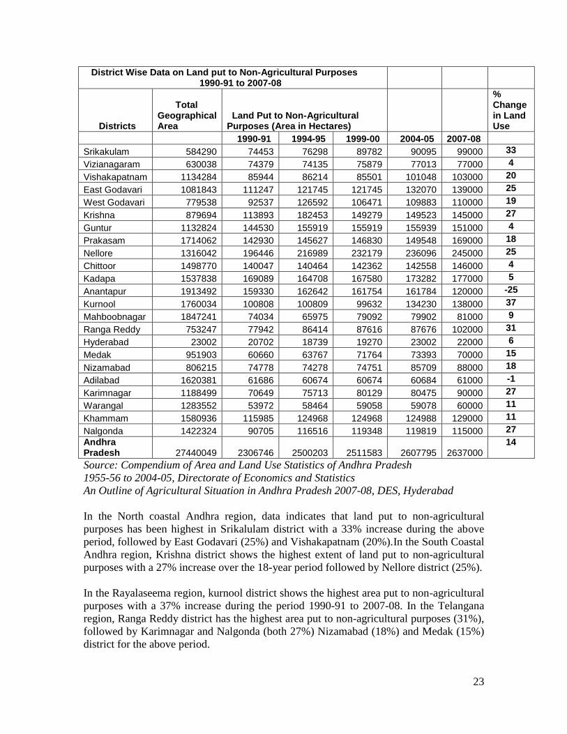
District Wise Data on Land put to Non-Agricultural Purposes 1990-91 to 2007-08
Districts
Total Geographical Area
Land Put to Non-Agricultural Purposes (Area in Hectares)
% Change in Land Use
1990-91 1994-95 1999-00 2004-05 2007-08
Srikakulam 584290 74453 76298 89782 90095 99000 33
Vizianagaram 630038 74379 74135 75879 77013 77000 4
Vishakapatnam 1134284 85944 86214 85501 101048 103000 20
East Godavari 1081843 111247 121745 121745 132070 139000 25
West Godavari 779538 92537 126592 106471 109883 110000 19
Krishna 879694 113893 182453 149279 149523 145000 27
Guntur 1132824 144530 155919 155919 155939 151000 4
Prakasam 1714062 142930 145627 146830 149548 169000 18
Nellore 1316042 196446 216989 232179 236096 245000 25
Chittoor 1498770 140047 140464 142362 142558 146000 4
Kadapa 1537838 169089 164708 167580 173282 177000 5
Anantapur 1913492 159330 162642 161754 161784 120000 -25
Kurnool 1760034 100808 100809 99632 134230 138000 37
Mahboobnagar 1847241 74034 65975 79092 79902 81000 9
Ranga Reddy 753247 77942 86414 87616 87676 102000 31
Hyderabad 23002 20702 18739 19270 23002 22000 6
Medak 951903 60660 63767 71764 73393 70000 15
Nizamabad 806215 74778 74278 74751 85709 88000 18
Adilabad 1620381 61686 60674 60674 60684 61000 -1
Karimnagar 1188499 70649 75713 80129 80475 90000 27
Warangal 1283552 53972 58464 59058 59078 60000 11
Khammam 1580936 115985 124968 124968 124988 129000 11
Nalgonda 1422324 90705 116516 119348 119819 115000 27
Andhra Pradesh 27440049 2306746 2500203 2511583 2607795 2637000
14
Source: Compendium of Area and Land Use Statistics of Andhra Pradesh
1955-56 to 2004-05, Directorate of Economics and Statistics
An Outline of Agricultural Situation in Andhra Pradesh 2007-08, DES, Hyderabad
In the North coastal Andhra region, data indicates that land put to non-agricultural
purposes has been highest in Srikalulam district with a 33% increase during the above
period, followed by East Godavari (25%) and Vishakapatnam (20%).In the South Coastal
Andhra region, Krishna district shows the highest extent of land put to non-agricultural
purposes with a 27% increase over the 18-year period followed by Nellore district (25%).
In the Rayalaseema region, kurnool district shows the highest area put to non-agricultural
purposes with a 37% increase during the period 1990-91 to 2007-08. In the Telangana
region, Ranga Reddy district has the highest area put to non-agricultural purposes (31%),
followed by Karimnagar and Nalgonda (both 27%) Nizamabad (18%) and Medak (15%)
district for the above period.

24
3. Diversion of Agricultural and Forest Lands for Development Projects
A study undertaken to understand the nature and impact of development-induced
displacement, especially in the tribal areas of Andhra Pradesh, Jharkhand, Chattisgarh
and Orissa revealed that a total of 12,04,522.64 acres of land have been acquired in the
four States broadly during the period 1996-2007. Water resources, industry, transport,
mining, and non-hydro power projects are the main categories of development projects
that have taken up a maximum extent of land in the tribal areas. The main types of land
acquired for these projects were private land, forest land and common land. Interestingly,
large extents of land acquired were shown as uncategorized land in the government
records (ActionAid, Indian Social Institute and Laya, 2008).
The study also revealed that a total number of 9, 94,355 persons were displaced (PD) by
these development projects and 22, 14, 884 were affected adversely be such projects
(PAP). The most disadvantaged by these development projects were members of the
Scheduled Tribes (ibid, 2008). The study used Official Gazette Notifications related to
land acquisition in the study States for the study period or years and combined this with
qualitative data collected in the form of in-depth interviews and discussions with
displaced communities in the affected areas as well as with other knowledgeable persons
in some sample districts within each State.
In Andhra Pradesh, the researchers scanned a total number of 1184 gazette notifications
related to land acquisitions issued for development projects related to water resources,
industry, Mines, non-hydel power projects, defence and security, transport and
communication, environment protection, human resources, refugee settlement, urban
development, housing, social welfare tourism, health services, education, government
offices and infrastructure, others etc. The highest numbers of notifications were related to
housing (449), followed by water resources (308), mining (196), urban development (67)
and transport and communication (49).
A category wise segregation of projects, location and extent of land acquisition based on
the above Gazette notifications for the period 1996-2007 revealed the following.
S.No Category of Projects Location/Districts Land
Acquired (in
Acres)
Period of
Acquisition
1. Water Resource Projects Adilabad, Karimnagar,
Mahbubnagar, Nalgonda,
Nizamabad, Warangal, Prakasam,
East Godavari, Kurnool
2651.03
1996-2006
2. Industry Kadapa, E.Godavari, Guntur,
Karimnagar, Khammam, Krishna,
Kurnool, Medak, Nellore,
Prakasam, Rangareddy,
Vishakapatnam, Vizianagaram,
Warangal, W.Godavari
1891.21
1996-2007

25
3. Mines E.Godavari, Guntur, Karimnagar,
Krishna
107.76 2001-06
4. Non-Hydro Power
Projects
Guntur, Krishna, Medak 37.78 1996-2000
5. Defence Establishment
Projects
Not specified
9273.41
-
6. Environment Protection Not specified 32.25 2001-07
7. Transport and
communication
E.Godavari, Khammam,
Srikakulam, Vizianagaram,
Vishakapatnam
72.41 1996-2007
8. Urban Development
Projects (include
landscapes, Parks,
Flyovers etc)
Not Specified 4225.39 1996-2007
9. Housing (includes rural
housing, temple
construction)
Not Specified
35520.83
1996-2006
10. Education (schools,
universities, technical &
professional institutions)
Not Specified
8767.02
-
The limitation of using Gazette notifications as a data source is the lack of data regarding
the extent and type of land acquisition for various projects. The Gazettes only provide
data with regard to the acquisition of private lands, under the Land Acquisition Act,
1894. There is no data available with regard to resumption of government lands assigned
to the poor or other government lands and forest lands. In six sample districts selected for
the study – East Godavari, West Godavari, Khammam, Srikakulam, Vizianagaram and
Vishakapatnam, the researchers used data from gazette notifications along with a variety
of other sources including government files, records, project reports, articles, media
reports and interviews with key officials and activists for the period 1996-2007.
District wise disaggregation of the above data revealed the following.
S.No District Land Acquired
(in Acres)
1. East Godavari 33917.06
2. Khammam 129939.1
3. Srikakulam 40868.35
4. Vishakapatnam 30722.36
5. Vizianagaram 11906.99
6. West Godavari 53526.18
Total 300880.00
Source: Resource Rich, Tribal Poor: Displacing People, Destroying Identity in India’s
Indigenous Heartland, A Report by ActionAid, Indian Social Institute, Laya, 2008

26
The data revealed that around 3,00,880 acres of land was acquired across various
categories of projects like water resources, industry, mines, non-hydel power
projects, housing, defence and paramilitary, social welfare, transport and
communication, tourism and government offices. Of this, 33924.51 acres was private
land, 66245.16 acres was forest land and 14055.21 acres was common land and 186618.4
acres of land whose categorization is unknown.
4. Diversion of Forest Land for Mining
In response to a question in the Lok Sabha, LS USQNo.3908, asked by Prahlad Venkates
Joshi, Maneka Gandhi and Jaswant Singh Bishnoi related to the extent of forest lands
diverted for mining proposals, Mr. Namo Narain Meena, then Minister of State in the
Ministry of Environment and Forests responded with State wide details which indicate
that around 13,531.61 hectares of forest land in Andhra Pradesh was diverted for
mining purposes (Parliament Digest, Monsoon Session, 2005, NCAS). As per the
official data brought out recently by the Ministry of Forests and Environments, an
estimated 3.68 lakh hectares was regularised in the past 20 years out of the total
10,94,059 hectares of forest land diverted under the Forest Conservation Act, 1980 for
various activities. The Centre also approved 64 proposals from various states such as
Karnataka, Andhra Pradesh, Madhya Pradesh and Bihar seeking diversion of forest land
to illegal occupants including farmers and nomads in the said period. Almost 21.93 per
cent (2.40 lakh hectares) of forest land was diverted for rehabilitation purpose as well as
setting up schools and hospitals while 34 per cent land was utilised for Hydel (10.42%),
Irrigation (10.96%) and Mining (11.70 per cent) projects. Also, 16 proposals were
approved for forest village conversion for which 41,170 hectares of forest land was
diverted. "Proposals of the state and UT governments, submitted after they got approval
of the Supreme Court, are considered for regularization by the Central government under
the provisions of the Forest (Conservation) Act.
Following the economic reforms, there has been a massive entry of private capital
including multinational corporations for the exploitation of natural resources for profit.
Several State Governments began to sign memorandums of Understanding (MOU) with
these companies. Most of the MOU’s were signed in resource rich States like Orissa,
Jharkhand, Chattisgarh and Andhra Pradesh followed by some other States. In Andhra
Pradesh alone, around 40 MOU’s were signed with various companies and corporations
in the name of accelerating development in tribal areas.
5. Diversion of Farm land to Special Economic Zones (SEZs)
In March, 2000, the Government of India (GOI) introduced guidelines for Special
Economic Zones (SEZs) during by revising the Export-Import Framework 1997-2002.
Soon after this, the Government of Andhra Pradesh came up with a Policy framework for
Special Economic Zones (SEZs) in the State through a G.O.Ms.No.151 through the
Department of Industries and Commerce in April 2002. The previous Telugu Desam
Party Government in Andhra Pradesh headed by Mr.Chandra Babu Naidu took an active
lead in setting up SEZs in the State. In a letter to the then Union Minister of Finance, Mr.

27
Jaswanth Singh, the AP Chief Minister informed that the State was the first in the country
to announce an exclusive State SEZ Policy with a whole range of incentives and
concessions. Two large multi-product SEZs in Vishakapatnam and in Kakinada, East
Godavari district were finalized during this period. After the Government of India passed
the SEZ Act in 2005, the Congress Government in AP submitted a draft APSEZ Bill to
the Council of Ministers who approved the draft Bill in December 2005.
As on March 2010, Andhra Pradesh has a total number of 106 SEZs -the 2nd
highest in
the country after Maharashtra. Out of 106, 73 SEZs have been notified, which is the
highest in the country (notified means land has been acquired and the area has been
notified as SEZ through a formal Gazette notification by GOI, Ministry of Commerce. It
also means the developers have availed the initial set of tax concessions under the SEZ
Act such as registration, stamp duty etc). In the remaining SEZs, land acquisition is still
in progress. Neither the central SEZ Act nor the APSEZ bill has any clear cut norms
related to acquisition of lands, especially agricultural lands, for setting up SEZs.
Amongst various incentives being given to developers of SEZs in the State, provision of
land at desirable locations and at attractive prices is a major incentive. According to the
official data, the total land acquired for over 100 SEZs in all categories (notified,
formal and in-principal) all over the State is about 33,296 acres. A research study of
16 SEZs in 9 districts shows that 49,575 acres have so far been alienated for purposes
SEZs. Of this, close to 30,000 acres are assignment lands and other government lands,
which have been resumed back or alienated from the poor for the purposes of SEZs. This
means that the actual extent of land handed over to SEZs could be 2-3 times higher than
official data (Seethalakhmi.S., 2008). Five large multi-product SEZs in Andhra Pradesh
namely – APSEZ in Vishakaptnam, Sri City Infra Reserve in Chittoor, Lepakshi
Knowledge Hub SEZ in Anantapur, a multi-product automobile SEZ in Nellore – 6000
acres and the Kakinada SEZ in East Godavari alone take up an area of 42,600 acres.
According to a report published in Andhra Jyothi, a leading daily in the State, around
75,000 acres of land have been acquired for various SEZs in AP (Andhra Jyothi, January
27, 2009).
Under the Andhra Pradesh Assigned Lands (prohibition of Transfers) Act, 1977,
which was aimed at protecting the interest of the original assignees, the authorities
were under the obligation of restoring the assigned land back to the original
assignee after resuming the same from the transferee under void transfer. However,
by virtue of a subsequent amendment to this act in the form of amendment Act No.8
of 2007, the government is empowered to use the resumed assigned land in the
notified areas for infrastructural development and promotion of Industries, without
assigning the same to the original assignee. In short, what was given by the State
Legislature to landless poor persons by one hand has been taken away by another,
by virtue of the Amendment Act 8 of 2007. The resumption of large areas of
assignment lands in the name of “Public Purpose” such as for SEZs by the
government is made easy with the assignment Patta or “D” form Patta conditions
aiding or permitting the same The land acquisition notifications for many public
purposes, including SEZs does not show assigned lands but only private patta lands.

28
The Government lands which are given to SEZs are shown no where because it is
treated as the private affair of the Government.
With a view to minimizing the loss to the farming sector, the state governments were
advised that in case of land acquisition for Special Economic Zones (SEZs), priority
should be given to waste and barren land, and if necessary, single crop agricultural land
could be acquired for SEZs. If, perforce, a portion of double cropped agricultural land has
to be acquired to meet the minimum area requirements, especially for multi-product
SEZs, the same should not exceed 10% of the total land required for the SEZ. In Andhra
Pradesh, contrary to official claims that the lands being diverted to SEZs are barren,
uncultivable lands, field research reveals that most of the lands diverted are single and
two crop lands. In some places like Kakinada and Chittoor, the lands diverted to SEZs are
multi-cropped lands or comprise of fruit orchards (ibid, 2008).
The resumption of assignment lands and alienation of other government lands for SEZs
and other public purposes needs to also be placed in a macro context to draw out some of
the implications. According to the 2001 census data, the population of SC’s in AP was
around 1.23 crores, forming around 16% of the State’s population. The AP Agriculture
census of 2005-06 shows that the SC operational area is 28.4 lakh acres. Close to 50% of
the land holdings of SC households are assignment lands accessed through the
governments’ land distribution programmes. In India, the government land distributed is
almost three times more than ceiling surplus land and accounts for about 6 percent of
total cultivated area in the country. Andhra Pradesh with 42.02 lakh acres (28.49%) leads
the league followed by Uttar Pradesh with 24.89 lakh acres (28.49%) (GOI, 2006,
pp.240-241). In 2004, the Congress Government in AP constituted a Land Committee
under the chairmanship of Sri Koneru Ranga Rao to comprehensively assess the
implementation of land reform process and suggest suitable measures. According to the
report submitted by this Committee, between 1969 to 2002, about 42,24,000 acres of
government lands have been assigned to 29,23,000 landless households (Land Committee
Report, 2006). Although on record the Government has assigned more than 42 lakh acres,
the Land Committee report notes that far less is in the hands of the poor and under
cultivation.As part of the much trumpeted land distribution programme of the Congress
government, another 6,40,000 acres had been assigned in 4 phases during the last 5 years
to 4,33,000 households (www.ccla.ap.gov.in). According to official estimates, around
4.45 lakh acres of land distributed to the poor for cultivation has gone out of their hands
or been alienated.
7. The role of State Corporations and Agencies in Land Diversion.
The large scale diversion of farm land has been facilitated through relaxing land
acquisition procedures and ceiling regulations by various states post 2000 and has
resulted in the State itself turning into one of the largest real estate broker and developer
in the country. In Andhra Pradesh for example, the Andhra Pradesh Industrial
Infrastructure Corporation (APIIC), a wholly owned undertaking of the Government of
AP has been playing a major role in acquiring all kinds of lands around the State for
promoting industrial parks, SEZs, infrastructure projects etc. The Corporation has been

29
accused of buying lands, often from small and marginal farmers at cheaper rates and then
selling them for higher amounts to the industrialists and investors. Between 1974-2004,
APIIC had a land bank of 48,579 acres but this saw an almost three-fold increase in
the five year period between 2004-2009 and as on June 2009, the total land bank
with APIIC was an extent of 1,21,655 acres. Over 60% (76,566 acres) of this land
bank with APIIC comprises of government lands. Of this, an extent of only close to
18,000 acres had been allotted as on 2009, which then indicates that the Corporation
was still holding on to a land bank of over 1 lakh acres. In over 43% of the SEZs, the
APIIC is playing the role of a developer or a co-developer.
The Deccan Infrastructure and Land Holdings Limited (DILL) is a Company registered
under the Companies Act, 1956 as a subsidiary of Andhra Pradesh Housing Board
(APHB). In Deccan Infrastructure and Land Holdings Limited (DILL), APHB holds
57.44% of the Equity and the Government of Andhra Pradesh (GoAP) holds 42.56%
Equity. The Equity holding of APHB and GOAP has come by way of transfer of their
respective lands. The company’s mission is to develop and construct Integrated
Townships and implement Urban Infrastructure Projects and provide Urban Housing
Solutions, not only in Andhra Pradesh but also outside the state and country. The Chief
Secretary, GOAP is the Chairman of the Company. The Principal Secretaries of Revenue
and Finance Departments, GOAP, are part of the Board of Directors of the company,
amongst others. It is significant that the APHB floated a subsidiary company in the form
of DILL in the backdrop of the real estate boom in and around Hyderabad and transferred
4,170 acres of government land in Ranga Reddy, Mahaboobnagar, Medak and Nalgonda
districts to the company. DILL has come into being as part of the National Housing
Policy and is poised to have a land bank of about 7,000 acres, mostly in and around
Hyderabad, for developing integrated townships. As per media reports, around 4,170
acres – 288.87 in Ranga Reddy, 959.64 in Medak, 1,197.17 in Nalgonda and 1,723.70
acres in Mahaboobnagar – have been transferred to DILL by the State Government and
the value of these lands is said to be between Rs 5,000 and 6,000 crore. (May 2, 2007:
New Indian Express).It is again significant that it is in these four districts along with
Vishakapatnam that DILL is involved as a developer in 14 SEZs, which have received
formal approval from the Board of Approval (BOA) under the Commerce Ministry.
In April 2007, a central Empowered Group of Ministers (EGoM) decided that the
State Governments cannot acquire lands for setting SEZs or other public purposes,
especially for private parties. The developers will have to do it on their own. To
ensure that existing projects do not get hit by this decision, the EGOM decided to fix
February 10, 2006 as the cut off date. Where the State has gone for compulsory
acquisition for any proposal after the above date, the BOA would not grant
clearance for the same. This clause is also expected to be built into the
Comprehensive Land Acquisition Act. In the context of AP, this decision barely
makes a difference for two important reasons. Firstly, large tracts of lands being
transferred for SEZs and for other public purposes are assignment lands or
governments’ lands which are already in governments own possession. Secondly,
where State agencies like APIIC and DILL have been designated as nodal agencies

30
for developing SEZs, integrated townships, most of the land acquisitions have been
made prior to the above cut-off date of 2006.
8. Urban Development Agencies and their role in Land Diversion
Increased urbanization and growth of cities in the last two decades has also led to an
expansion in the powers and jurisdiction of Urban Development Corporations and
agencies, especially in matters related to sale and purchase of land for various purposes in
urban areas and its peripheries. In this context, urban development agencies like
Hyderabad Urban Development Authority, Vishakapatnam Urban Development
Authority etc have been invested with expanded role and powers.
Evidence from field research reveals that there has been a large scale sale of agricultural
lands for real estate purposes in and around Hyderabad extending to neighboring districts
like Ranga Reddy, Medak, Nalgonda, with the extension of the city limit to several
mandals in these districts. There has been a rise in speculative real estate in these areas in
the past 10 years. The same patterns can be seen in and around Vishakapatnam, Kurnool
town, Kakinada, Nellore, Anantapur and other rapidly emerging towns. The expansion of
infrastructure, transport and communication in terms of road, air and sea connectivity in
and around these towns has led to an increased investment in real estate, IT parks, SEZs
etc in these places. All these developments have entailed large scale loss of agricultural
land. Agencies like HUDA have earned large sums of money through auctioning off
lands to interested private buyers for very high sums of money in and around Hyderabad
city as well as giving permissions for housing layouts on agricultural land. The same is
the case with VUDA too (see next chapter of this study for more details).
The actual extent of conversion of agricultural lands to non-agricultural purposes in
Urban peripheries is not known since most of the conversion for real estate ventures or
housing purposes go unrecorded by the revenue authorities. It was not possible to get
accurate data related to the extent of conversions during the course of this study from the
concerned revenue division officers. Even where data is available, officials admit that the
figures could be underestimates. For example, in Vishakapatnam division, the total
number of applications after the new conversion Act came into being in 2006 is only 158,
amounting to an area of 878 acres of agricultural land.
According to one estimate, between 2002 and 2007, about 90,000 hectares of agriculture
land across 25 mandals in and around Hyderabad has been diverted for real estate and
mega-projects. Another 63,000 hectares across 20 mandals of Ranga Reddy district has
been lost in the last 10 years. Even at a conservative estimate, some researchers point out
that a mind-boggling five lakh hectares of agriculture land has been lost in Andhra
Pradesh in recent years (Reddy, V.R. and Suresh Reddy, EPW, 2007).
Evidence from various media reports in the last few years (Times of India, March 2007,
Andhra Jyothi, February, 2010) reveal that the revenue recoverable from conversion of
farm lands to other purposes from Ranga Reddy alone under the 2006 Act amounted to

31
over Rs. 2000 crores. Field research as part of this study in Medak district also reveals
that the revenue forgone on account of conversion of lands is around 75 crores and that
too for a few mandals adjoining Hyderabad. The same is the case in and around Kurnool
town too.
In a significant decision, the GOAP passed ‘The A.P. Agricultural Land
(Conversion for Non-Agricultural Purposes) Act, 2006 (Act No.3 of 2006) aimed at
regulating the conversion of agricultural land to non-agricultural purposes in the
State. This Act, after being passed in the AP Legislative Assembly received the
assent of the Governor on 3oth December 2005 and came into force on January 2,
2006 through a GO.MS. No 193, published in the AP Gazette for general
information. Through this Act, the GOAP also repealed and abolished an earlier
Act in the form of ‘The Andhra Pradesh Non-Agricultural Land Assessment Act,
1963 (NALA) by introducing a levy in lump sum at the rate of 10% of the basic
value of land in arrears, which the government may fix from time to time, at the
time of conversion by undertaking a specific legislation. The Act is actually aimed at
facilitating rather than regulating the conversion and diversion of agricultural land
to non-agricultural purposes. The 3 of 2006 Act does defines the term “non
agricultural land” very loosely and broadly to refer to land other than that used
exclusively for the purposes of agriculture. Further, section 7 of the Act says that
“Nothing in this Act shall apply to “(a) Lands owned by the State Government”, and
“(e) Lands used for such other purposes as may be notified by the Government from
time to time,”. More importantly, while this Act prescribes rules for conversion of
agricultural land for other purposes, levy of conversion fee, penalty, advance notice
to competent authority etc, it does not lay down any clear rules/norms for regulating
land use, following conversion. This leaves the field wide open to private interests
and real estate agents to pursue their own uses on the lands.
In May 2010, the revenue department served notices to the APIIC asking the Corporation
to pay an outstanding amount of Rs.1500 crores as conversion fee towards conversion of
agricultural lands to non-agricultural purposes. The Corporation is to pay Rs.800 crores
for conversion of farm lands in Vishakapatnam and Rs.700 crores in Ranga Reddy
district. Similarly, DILL was also asked to pay conversion fees to the towards conversion
of farm agricultural lands in Ranga Reddy district.
9. Diversion of Farm lands to Infrastructure, Port and Special Investment Regions
In the Coastal areas, the establishment of SEZs has adversely affected the livelihoods of
fishing communities in a big way in Vishakapatnam, East Godavari and Nellore districts.
The livelihoods of those dependent on agriculture, fishing as well as salt pans is also
seriously at stake here. Specific port based industrial corridor projects such as the
development of the Gangavaram port in Vishakapatnam and the Krishnapatnam port in
Nellore as well as the Vaderevu and Nizampatanm port and Industrial Corridor project
(VANPIC) between Prakasam and Guntur districts have together cost an estimated
35,000 acres of land loss in these districts. Additionally, proposals for initiating other

32
projects such as the Coastal Industrial Corridor across the 9 coastal district and the
Petroleum, Chemical and Petrochemical Investment Region (AP PCPIR), the first phase
of which recently received clearance from the Central cabinet in October 2009 are going
to cause large scale loss of farm lands and fishing areas in these regions. For example, the
development of just the first phase of the AP PCPIR between Vishakaptnam and
Kakinada is projected to be in an area of 604 square kilometers requiring around 1.49
lakh acres of land. The APIIC, which is facilitating this project claims that already 70%
of the proposed land area is in its possession through a cluster of SEZs, pharma parks etc
located in the earmarked area. The total investment expected is above 3 lakh crores over a
period of 7-10 years. As part of developing the first cluster of the AP PCPIR between
Vishakapatnam and Kakinada, heavy investments are also going to be made to expand
the NH 5 into a six lane road and NH 214 into a 4 lane road for greater connectivity.
The GOAP released a specific GO.373 for the purpose of developing AP PCPIR. The
G.O draws its basis from the Andhra Pradesh Urban Areas (development) Act, 1975
under which Special Urban Development Authorities were to be constituted for certain
priority areas towards achieving the dual objectives of orderly growth and environmental
conservation in such areas. Due to the PCPIR and other projects project, it is estimated
that around 14 lakh fisherfolk would loose their livelihoods. Of the 96 lakh tons of Rice
produced in the state, 67 lakh tons come from this region alone. The Coastal Corridor
Project will completely erode this Food Basket of the state. Fish production valued at
nearly Rs. 6,700 crores comes from the 9 coastal districts. In addition nearly 5, 82,000
tons of fish and prawns are produced along the coast. All this fish produce and economy
of 80 lakh fisher folk is going to be seriously threatened due to the above projects.
In AP, a spate of earlier legislations like the AP Land Reforms (Ceiling on
agriculture holdings) Act of 1973 had not been properly implemented. As per the
Ceiling Act, it was estimated that 16.63 lakh acres of surplus lands would be
recovered. However, only for 7,89,911.40 acres, ceiling surplus declarations were
made and out of this, 5,82,374.42 acres were distributed to the poor. The remaining
2,07,536.98 acres remains undistributed for various reasons (Land Committee
report, GOAP, 2006). In recent times, this legislation has been amended twice to
facilitate land transfer to public purposes like industries, infrastructure projects etc.
In the context of expansion of urban areas, the government says that it is not
possible to distribute ceiling surplus lands to the poor for cultivation purposes. In
2009, the Congress Government amended the section 14, clause 3 of sub-section 6 of
the AP Land Reforms Act for the first time by adding the key words basic
infrastructure, development of industries or public purposes in the Act. The first
amendment was confined to ceiling surplus lands recovered in the peripheries of
urban areas. The Act was amended a second time to be extended to the entire State.
Interestingly, the amendment was made in the context of diverting ceiling surplus
lands to Krishnapatnam Port where the developers had problems accessing bank
loans, given that some parts of the land was ceiling lands. The amendment was
brought in to enable the government to sell ceiling surplus lands to industries,
instead of distributing them to the land less poor as per the objectives of land
reforms.

33
10. Conversion of Agricultural land to Plantations
Along with diversion of agricultural land, conversion of farm land to plantations in the
form of oil palm, bio-fuels, eucalyptus, casurina etc for commercial purposes is also
posing serious challenges to land available for food production.
Andhra Pradesh stands 1st in area, production and productivity under Oil Palm. An area of
17,409 hectares has been covered under oil palm during the year 2008-09. Under this
project, assistance is being provided towards plant material, cultivation, micro irrigation
and inter crops besides organizing training programmes. During 2009-10, an area of 2,551
hectares has been brought under Oil palm cultivation so far.Two oil palm seed gardens
were established in the state, one by department and another in private sector. The seeds
are produced at these gardens under the technical guidance of National Research Centre
(NRC) Oilpalm, Pedavegi Center in West Godavari District and supplied to Oilpalm
companies. 12 companies with a processing capacity of 98 MTs per hour are working with
the Government under this program. The companies have buy-back arrangements for
purchase of Fresh Fruit Bunches (FFB’s) from the farmers in the factory zone at the rate
fixed by the Government. In Andhra Pradesh, the following 11 districts have been
identified for oil palm cultivation. Srikakulam, Vizianagaram,Visakapatnam, East
Godavari, West Godavari, Krishna, Guntur, Prakasam, Nellore, Chittoor and Khammam.
District wise area In Andhra Pradesh as on 31.3.2008
S.No. District Area
Covered (ha)
1 East Godavari 15246
2 Guntur 1,323
3 Khammam 5442
4 Krishna 6128
5 Nalgonda -
6 Nellore 3432
7 Prakasham 1,114
8 Srikakulam 1848
9 Visakhapatnam 2729
10 Vizianagaram 5472.5
11 West Godavari 34593.5
Total 77328
Source: www.agriap.nic.in
Districts wise Potential area suitable for oil palm cultivation in Ha.
1. Srikakulam 35,000
2. Vizianagaram 20,000
3. Visakapatnam 10,000
4. East Godavari 1,00,000

34
5. West Godavari 1,00,000
6. Krishna 50,000
7. Guntur 20,000
8. Prakasam 10,000
9. Nellore 30,000
10. Khammam 20,000
11. Chittoor 10,000
-----------
Total 4,10,000
-----------
Under Cashew Plantation in Andhra Pradesh, a total area of 1,66,163 hectares of area is
covered as on 2007-08. In North Coastal Andhra, Srikakulam and Vishakapatnam
districts have an area of 22355 hectares and 22925 hectares respectively under cashew
plantations in 2007-08. In South Coastal Andhra region, West Godavari district had a
total area of 40625 hectares under cashew in 2007-08. In Telangana region, Khammam
district had an area of 10,405 hectares under cashew plantations.
Evidence from field research show that new forms of land consolidation and land leasing
is occurring in parts of Srikakulam district, especially in relation to conversion of
agricultural lands and forest lands to oil palm and other plantation crops in recent years.
These are explored in greater detail in the next section of this report.
An overview of data on the performance of Agriculture and patterns of land diversion
over the last two decades in the State indicates that the impact of these shifts have not
been even across the State. The decline in the performance of the agricultural sector
along with emerging patterns of land diversion discussed here have been different in
various regions and districts across Andhra Pradesh. Based on findings from field
research in five sample districts, the specific impacts of these changes over the last two
decades along with the impact of policy shifts are discussed in the next section in detail.

35
4. Understanding Changing Dimensions of Land Use on Ground:
Findings from Study Districts
While there is no accurate estimate of the extent of farm land diverted to various
purposes in the State, existing data from various sources clearly indicates that the extent
and pace of diversion have been increasing over the last two decades or so. A review of
policy changes and overall governance of land in the State during the last two decades
also indicates that land diversion has been facilitated due to key shifts in official policies
and programmes. Findings from analysis of official data and initial field research in five
districts again show the manner in which various policies bear out on ground in terms of
their linkage to processes of land diversion and their impacts. The districts selected for
primary field research include Ranga Reddy and Medak in Telangan region, Kurnool in
Rayalaseem region and Vishakapatnam and Srikakulam in North Coastal Andhra region.
Findings emerging from discussions with a cross section of people like officials of
various departments, field level organizations, activists and farmers etc are presented
here.
I. Kurnool Disrict
Kurnool District is located in the west-central part of Andhra Pradesh and lies in the
southern banks of the Tungabhadra and Handri rivers. The district was earlier the Capital
of Andhra Pradesh State from 1st October 1953 to 1st November, 1956 and at present the
headquarters of the district. The name Kurnool is said to have been derived from
“Kandanavolu” (Town of grease) since the locals supplied oil for greasing carts here and
the town subsequently became Kurnool. The district is now the administrative center and
a major market for grain, hides, and cotton. Kurnool covers an area of 17,658 sq km and
has a population of approximately 40 lakhs. The district comprises 3 Revenue Divisions –
Kurnool, Kallur and Nandyal with 54 Mandals. Apart from Paddy, Groundnut and
Bengal Gram are the major crops in Kurnool district.
1. Understanding Changes in Land Utilization Pattern in the District
With regard to land utilization patterns, kurnool district shows the highest area put to
non-agricultural purposes (LNA) in the Rayalaseema region, with a 37% increase during
the period 1990-91 to 2007-08.
Land Utilization Patterns and Crop Area in Kurnool District 1990-2008
Year LNA CF Rice Jowar
Bengal
Gram
Red
Gram
1990-91 100808 105344 77318 162061 20019 27275
1994-95 100809 146004 73123 141810 28402 20591
1999-00 99632 188439 95191 99636 54393 26917
2004-05 134230 141956 39584 117600 139705 33577
2007-08 138000 129000 93167 73236 217586 33003
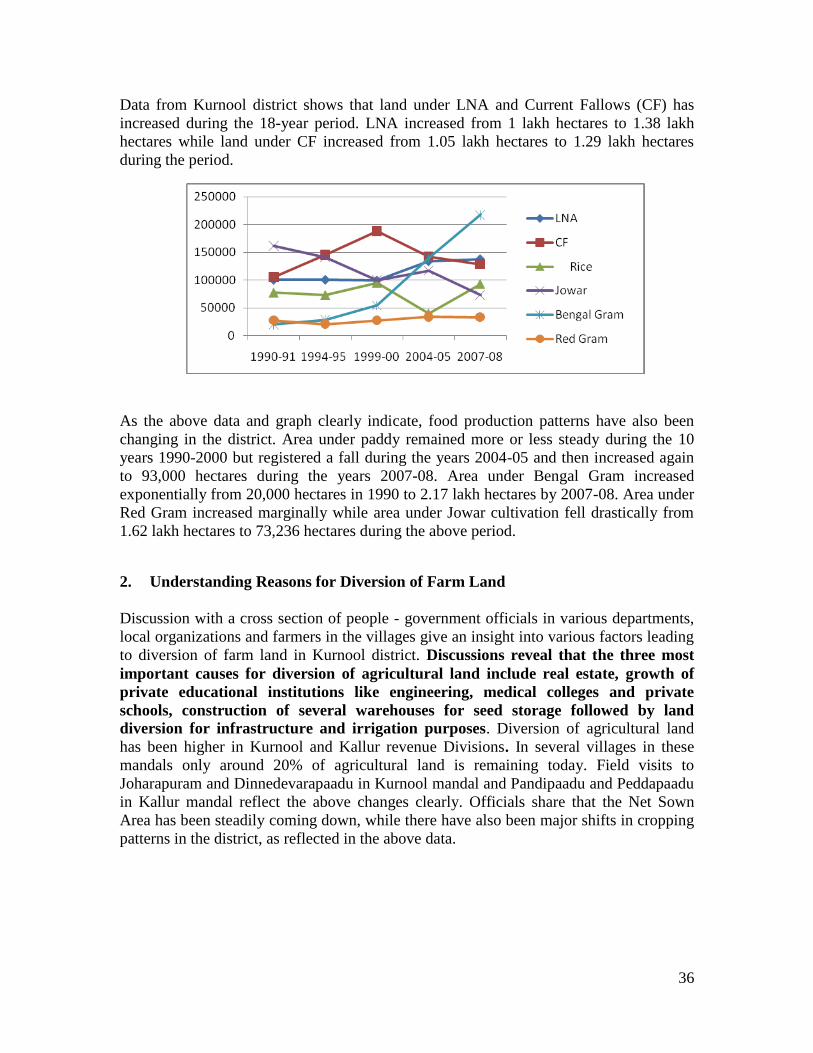
36
Data from Kurnool district shows that land under LNA and Current Fallows (CF) has
increased during the 18-year period. LNA increased from 1 lakh hectares to 1.38 lakh
hectares while land under CF increased from 1.05 lakh hectares to 1.29 lakh hectares
during the period.
As the above data and graph clearly indicate, food production patterns have also been
changing in the district. Area under paddy remained more or less steady during the 10
years 1990-2000 but registered a fall during the years 2004-05 and then increased again
to 93,000 hectares during the years 2007-08. Area under Bengal Gram increased
exponentially from 20,000 hectares in 1990 to 2.17 lakh hectares by 2007-08. Area under
Red Gram increased marginally while area under Jowar cultivation fell drastically from
1.62 lakh hectares to 73,236 hectares during the above period.
2. Understanding Reasons for Diversion of Farm Land
Discussion with a cross section of people - government officials in various departments,
local organizations and farmers in the villages give an insight into various factors leading
to diversion of farm land in Kurnool district. Discussions reveal that the three most
important causes for diversion of agricultural land include real estate, growth of
private educational institutions like engineering, medical colleges and private
schools, construction of several warehouses for seed storage followed by land
diversion for infrastructure and irrigation purposes. Diversion of agricultural land
has been higher in Kurnool and Kallur revenue Divisions. In several villages in these
mandals only around 20% of agricultural land is remaining today. Field visits to
Joharapuram and Dinnedevarapaadu in Kurnool mandal and Pandipaadu and Peddapaadu
in Kallur mandal reflect the above changes clearly. Officials share that the Net Sown
Area has been steadily coming down, while there have also been major shifts in cropping
patterns in the district, as reflected in the above data.

37
2.1 Higher Diversion of Farm Land in Kurnool and Kallur Mandals
Mr. Balasubramanyam, Sub-Registrar, Kurnool Mandal shares that within the district,
land diversion has been the highest in Kurnool and Kallur mandals. In 35 villages
(including revenue and hamlet) of Kallur mandal, large extents of agricultural land have
been lost over the last two decades. In Kurnool mandal, land diversion has been highest
in villages like Joharapuram, Pasipala, Rudravaram, Dhinnedevarapaadu, Taandrapaadu-
B, Venkayyapally, Sudireddypally, Maasta Masid, Panchalingala, Munagalapaadu,
Maamidaalapaadu, Stantanpuram etc. In most of these villages, only around 20% of
agricultural land is remaining today. In Kallur Mandal, agricultural land diversion has
been the highest in villages like Pandipaadu, Lakshmipuram, Dhoopaadu, Chinna Tekuru,
Pedda Tekuru, Vaaamasamudram, Tadakanapally, and Peddapaadu.
The process of land diversion began around 1986-87 when real estate business began to
pick up in and around the peripheries of Kurnool town and other big municipalities like
Nandyal. Some of the big real estate ventures that have come up in the district include
Shilpa Real Estates (promoted by the current Minister for Housing in the Congress
Government, Mr. Shilpa Mohan Reddy), B.K Singh Ventures, V.V.R. Housing, Maruti
Constructions, Raaga Mayuri Ventures (Resorts). Other big promoters of hotels, factories
and commercial establishments include the T.G Group owned by Mr. T.G. Venkatesh as
well as well known names in the textile/apparel sector such as Chandana Brothers, who
have brought over 500 acres of land in Thippaipalli village of Urvakal Mandal.
According to Mr. M. Sundara Rao, Senior Assistant at the Sub-Registrar Office, Kurnool,
shares, that beginning from 1999, around 3500 acres of land has been registered for non-
agricultural purposes in over 35 villages (excluding wards) in Kurnool and Kallur
mandals. According to Mr. Vidyasagar, the deputy Mandal Revenue Officer, Kallur
mandal, there are 21 revenue villages and 10 hamlets in Kallur mandal and the total
agricultural land in the mandal is around 28,000 acres. Of this, about 1500 acres of land
has been diverted for other purposes over the last 20 years. Real estate is a major cause
for conversion of agricultural land apart from other infrastructure projects such National
Highway (NH- 4) for which around 200 acres of land was lost in Kallur mandal along
with around 400 acres in Veldurthi and Dhone mandals. However, according to other
activists working on the ground, the above figures from various officials could be under-
estimates.
2.2 Impact of Land Diversion and Conversion on Agriculture
Diversion of agricultural land has been higher in Kurnool and Nandyal Revenue
Divisions. The three most important causes for this diversion include real estate,
educational institutions like engineering, medical colleges and private schools,
construction of several warehouses for seed storage, infrastructure and irrigation
purposes, says Mr. S.V. Tulasi Prasad, Deputy Director, Agriculture.Mr. Veera Reddy,
Agricultural Officer, Kurnool shares that, “There are 30 warehouses and seed processing

38
godowns in and around Kurnool and Nandyal. Institutions like NABARD have financed
the construction of these structures. Each warehouse has taken up around 2-5 acres of
land. Several private engineering colleges and schools have come up in the 10 years,
each occupying an area of anywhere between 15-40 acres. In the last 10 years alone,
particularly after the Congress Government was elected, around 10 engineering colleges
have come up in and around Kurnool Municipality”.
Reflecting on changes in agricultural land use, Mr. Venugopal Rao, Assistant Director,
Agriculture, shares, “Over the last decade or so, along with alienation of agricultural
land, there is also land consolidation in the hands of a few. One can see a lot of
plantation in large areas of land belonging to few NRI’s or other influential people.
There is mostly mango, sweet lime etc on these lands. In the year 2004, the government
tried to promote bio-fuel plantation in 600 acres of land. The District Watershed
Management Agency (DWMA) provided 90% subsidy on drip irrigation on these lands. It
was an utter failure though and the scheme was withdrawn within a year. About 10 years
ago, a view from the Collectors Office (where the Agriculture Departments office is
located) showed paddy lands for several kilometers stretching up to the nearby
Joharapuram village. Now there is nothing and all the land has been used up for
construction and other purposes. Paddy, Groundnut and Sunflower are the major crops
in this district. Now, Bengal Gram is the single most widely grown crop in the district.
Around 6.5 lakh hectares of area is under Bengal Gram crop this year. Interestingly,
despite crop loss due to floods in the district, the Paddy output has perhaps been the
highest ever with a Kharif area of 86,000 hectares and Rabi in 39,000 hectares.
Sunflower has been sown in around 80,000-90,000 hectares. There have been
fluctuations in the Gross Sown Area over time but the Net Sown Area has been
drastically decreasing in the district. There is only 5-10% diversion of land to industries.
Some industries like the paper mills started by Mr. T.G.Venkatesh, the A.P Carbide by
Mr. Y.S. Rajasekara Reddy closed down after some time. In the Nallamala Forest Region,
forest land has been converted to agricultural land by some of the ex-MLA’s”.
Discussions with officials such as Mr. Vinayananda Kumar, Assistant Director in the
office of the Chief Planning Officer shows that as on 2007-08, a total area of 1,37, 796
acres of land has been put to non-agricultural purposes in the district. This is about 24%
of the total geographical area of the district. Land diversion is a direct consequence of
lack of irrigation and water facilities for agriculture. In the Nandyal Division, there is
better irrigation through the K-C Canal and Telugu Ganga Project. There is a larger area
and higher yield in commercial crops like Tobacco, Sunflower, Red Gram, Groundnut
etc.
3. Understanding Farmers perspectives on Diversion of Farm Land
Field visits to four villages in Kurnool and Kallur mandals and discussions with farmers
here helped in understanding the nature and forms of alienation of farm land and its
impact on their livelihoods.
39
3.1 Joharapuram Village, Kurnool Mandal
Joharapuram is a revenue village, located about 1.5 kilometers away from Kurnool town.
The village draws its name from Zaheerabee, the daughter of the village. The peculiarity
of this village is that the women are well established and therefore most of the men who
married them came to settle down in the village, instead of the women going away. The
village was earlier located on the banks of Tungabhadra river but moved further away to
resettle over a period of time.
Around 20 years ago, the village had 1500 households owning over 2000 acres of land.
Farmers also held lands in other neighboring villages such as Pasupala, Rudravaram etc.
Agriculture, agricultural labor and livestock rearing formed a major source of livelihood
to a majority of the households in the village. A majority of the households were Dalits,
followed by Muslims, BC’s and others.
“The process of land diversion actually began in the year 1975 and today over 70% of the
agricultural lands have been lost”, says Dasari Haridas, a farmer and a trained lawyer
from this village. “Earlier Maize, Bengal Gram, Red Gram, Groundnuts, Cotton,
flaxseeds, Tobacco, Turmeric, Castor and several varieties of vegetables such as
Tomatoes, Brinjal, Ladies Finger, Dosakai, Onion, Chillies, Bottle Gourd, leafy
vegetables etc were grown by the farmers in the village. These were sold in the King
market in Kurnool district,” he says. “My father built a house just through sale of
Dosakai. He sold 60-70 baskets of the vegetable daily, each priced at Rs.10. He earned
enough profit to build a house at Rs.35,000 those days, shares Potual Sekhar, another
farmer and social activist shares. Joharapuram was famous for its vegetables in the local
market.
Urbanization, growing demand for land for real estate, housing and other commercial
purposes led to gradual diversion of agricultural land from this village. Almost all the dry
land has been sold out. Today, only 500 acres of wet land, which is irrigated by the K-C
Canal is left in the village. With land being sold away, farmers have also sold away
livestock. Tractors have taken over bullocks over time. There has been a shift in cropping
pattern with paddy replacing most of the earlier crops. Bengal Gram and Ground Nuts are
also grown in patches but mostly paddy is grown and the land is left fallow. Farmers do
not keep milch animals anymore.
Most of the farmers who earlier owned some land have been migrating to Kurnool town
and elsewhere to work as daily wage laborers in construction sites and earn Rs.150/- per
day for around 12 hours of work. Availability of work is also not certain or regular and
often erratic. Most of the irrigated land left in the village is also leased out to tenant
farmers and sharecroppers. During the 1980’s, farmers in Joharapuram sold land for
Rs.30,000/- per acre. Today, one cent of the same land costs Rs.2-3 lakhs. Farmers
belonging to BC and other upper castes sold their lands and purchased lands in other
villages like Hussainapuram, Pasupala, Noothanapalle etc. However, most of the farmers
belonging to dalit communities did not buy any land. They sold their lands and used the
money to marry off their daughters, to educate their children etc. Many from the
40
community are today engineers, veterinary doctors, neurosurgeons, scientists,
government service etc.
“Caste relations have not changed much in the village, despite the change in economic
relations around land over time and the spread of education amongst the younger
generation in dalit households,” says Haridas. Some of the caste based practices continue
to persist. For example, even today, members of the Dasari community are expected to
perform Bajana (a form of singing) in the temple following any body’s death in the
village.
Mr. Ramaseshanna, a former Counselor from Joharapuram and a farmer, shares, “all the
rain fed lands belonging to around 200 households have been sold away over time. Very
few who sold their lands managed to buy lands again. Most of them have turned into
wage laborers over time. I sold my 5 acres of land for Rs.30,000 per acre in the year 1983
and then brought lands in Hussainepuram village with the money. Today, the land I sold
costs Rs.5 crores per acre. The population in the village has increased over the years, with
many new settlements from outside. There are 3500 households in the village. However,
the only lands remaining in the village today are those irrigated by the KC Canal. Even
here, there has been complete crop loss due to floods last year. No Compensation has
been paid for the crop loss yet. Many new housing colonies and real estate ventures have
come up on farming lands of this village such as Saraswati Nagar, Vasavi Nagar, Ganesh
Nagar, Revenue colony, Rahul Estates, Laxmi Gardens, Dhanalaxmi Nagar, Somisetty
Nagar, Motherland, Ram Nagar, Maruti Estates, Maruthi Nagar, Golden Colony, Big
City, Chandramouli Nagar, Chandrasekhar Nagar, Sai Nagar etc. Some of the biggest
names in the real estate sector here are Mr.B.K.Singh, Maruthi Estates, Mr. K.G.Reddy,
Raaga Mayuri, Laxmi Builders, V.V.R etc”.
Over 70 acres of assigned lands belonging to this village has been taken up for the Rajiv
Gruha Kalpa housing Phase-2. No compensation has been paid to the land losers for the
same on the grounds that the original assignees have sold their lands to others and the
occupants had no clear title deeds. These lands were assigned to the landless poor over 50
years ago by the Government.
Basheer Un Bai, Mahboob Basha, Telugu Laxmi Narsamma and Mekala Kistamma are
all landless agricultural laborers in Joharapuram. Diversion of agricultural lands has
adversely affected their livelihoods over time. “Earlier, there was enough work for all of
us in the village. Now, work is uncertain and erratic. Many of us go out to work as
laborers in construction sites. Women are mostly taken for doing head loading of sand,
bricks, cement and mixing activities. We are paid Rs.150/- for working from 6am to 6
pm. If a couple from the same household get work”, says Basheer Un Bai. Fetching
Fuelwood and drinking water are major concerns for women in this village.Given that
Joharapuram is located in the peri-urban part of Kurnool Mandal, it is not covered under
the NREGS scheme. This means that many agricultural laborers are forced to go out of
the village in search of employment and livelihood. Goat and sheep rearers have also sol
away their flock over time.

41
3.2 Dinnedevarapaadu Village – Kurnool Mandal
Dinnedevarapaadu is a village located about 3 kilometers from Kurnool town. The village
earlier had around 200 households and a total extent of 1000 acres of land. Most of the
land was patta land and some parts surrounding the nearby Jagannadha Hills were
government land.
Diversion of farm lands began more than a decade ago. Today, with around 800
households and a population of 3000 people, the village has only 300 acres left. A large
extent of over 500 acres of land has been taken over Shilpa Real Estates, a real estate
venture promoted by Mr. Shilpa Mohan Reddy, Minister for Housing in the Congress
Government. It is also alleged that some additional land (assigned and other government
lands) has also been encroached by the above promoter. Around 100 acres of land has
been acquired by Raagamayuri Ventures for a Special Economic Zone. This land belongs
to both this and the neighboring Lakshmipuram village. About 20 acres of land has been
diverted for construction of quarters for the police and grey hounds personnel. The
owners of Pulla Reddy Engineering College brought over 50 acres of land and another
20-30 acres were purchased by the owners of a private school. Around 100-150 acres of
land has been diverted for setting up some molding and casting factory units.
Earlier, farmers in the village cultivated Maize, Bengal Gram, Ground nuts, Bajra, fox-
tailed millets, castor Tobacco etc. Only one crop was possible since the village did not
have any irrigation facilities. Most of the produce was kept for consumption and
groundnuts and tobacco was sold in the market.
One of the earliest factories to be set up in the district was the AP Carbide factory, which
was inaugurated by the late Chief Minister of the State, Mr. Bavanam Venkat Ram in this
village during the 1970’s. Around 18 acres of farmland was taken up for the factory.
Around 50 people from the village got employment in this factory. Due to default in
payment of electricity bills, the factory was closed down for a period of 10 years (1984-
94). The factory was brought over by Mr. Y.S. Rajasekhara Reddy, the late Chief
Minister of AP, who then re-opened the factory. Children of those workers who had
earlier worked in the factory and died received employment in the same.
The entire 500 acres of land taken over by the Shilpa Real Estates has been left fallow.
The Company brought these lands over 10 years ago at the rate of Rs.2.10 lakhs per acre
and sold each plot (measuring between 200 to 1500 square yards) up to Rs.4 lakhs.
Except two persons from the village, most of the buyers of these plots are from Kurnool.
Today, each acre costs Rs. 1 crore. Some of the farmers who sold their lands managed to
buy some land in other villages where they had relatives. Many others spent their money
and work as laborers in Kurnool town to earn their livelihood. While the Rural
Employment Guarantee Scheme is operational in this village, people say that only 50-60
days of work is available to them and the wages paid are also vary between Rs.75 -80,
below the mandated Rs.100 per day

42
The diversion of farmland to other purposes has also led to a gradual decimation of other
inter-dependent livelihoods. Kammari Ramachary, a bullock cart maker in the village
reflects on these changes, “Earlier, this village had around 120 pairs of bullocks. All
farming was done only through bullocks and there were no tractors. There were 5
households in this village that made and repaired bullock carts and ploughs. We had
regular work since repair of cart and plough is frequent on these drylands. Today, this
village has only 20 pairs of bullocks left. Tractors took over some time ago. There are no
cows and buffaloes and no dung is used in farming. There were 25 people in my family
and we all survived on the grain given generously to us in return for making and
repairing carts and ploughs. Earlier, there was the system of ‘Aakam’, where a fixed
quantity of grain was given to people of different castes for providing various services.
Along with us, the kummarolu and Erukulolu (pot makers and basket weavers) received
Aakam but now they are all gone. Only, the chaakali’s (washermen) are left today. In my
family, this occupation will also end with my time. My son is not interested in continuing
this work since it is not remunerative any more. Also, the wooden wheel is today replaced
by rubber and there is less work”.
Golla Naganna, who was earlier a farmer and livestock owner in this village, shares his
experiences. “I sold 7.5 acres of my land to the Pulla Reddy Engineering College for
Rs.50,000. This was in the year 1984-85. I did not buy any land anywhere. I have been
working as a laborer on Ramachandra Reddy’s farm for a monthly amount of Rs.1500/-
(Nela Jeetham). His family earlier owned 100 acres. They sold some of the land to
Shilpa. They now have 33 acres on which Groundnuts, Jowar, Sunflower, etc are grown.
Pinjari Moula Ali, a tenant farmer in the village shares, “I had 10 acres of land and I sold
it to Shilpa Estates for Rs.1.75 lakhs per acre. Now, I have leased out 5 acres of land
where I gorw castor, jowar, Bengal gram and Groundnuts. I sold away my lands to clear
my debts. I also purchased land in Chinnapaadu in Mahboobnagar. Many farmers from
here have brought lands there, almost 500 acres. I have brought 7 acres there. I lease out
the 5 acres here for an annual rent of Rs.750/- from a Kapu household. Earlier, Jowar
was a major crop in this village. The yield was good, around 7-10 quintals per acre.
Now, Bengal Gram (Chenega) is widely cultivated. There are also more agricultural
laborers in the village than farmers owning land. Women are paid Rs.50/- per day and
men are paid Rs.100/- .
Diversion of farm land has also changed the character of Dinnedevarapaadu village in
many ways. Many farmers from the village who sold away their lands have migrated out
or work as daily wage laborers in Kurnool and other places. There has also been a fair
amount of in-migration into the village, given its proximity to Kurnool town. Today,
more than 50% of the population of this village comprises of people from outside, since
rents are cheaper here and work is available close by in the town.

43
3.3 Pandipaadu Village, Kallur Mandal
Pandipaadu village in Kallur mandal comprises of roughly 400 households, mostly
belonging to Kamma, Kapu, Boya, Muslim and Dalit communities.
The village earlier had a total extent of 1600 acres of land. Jowar was a major crop and
was also widely consumed. Ground Nuts, Korra, Munagaara Patti (a variety of Cotton)
were also cultivated and farmers marketed their surplus in the Kurnool market.
Everybody had adequate land to farm and one family of Maddiletti Reddy alone had over
300 acres of land. The establishment of industrial estates, factories and real estate has led
to diversion of agricultural land over time. Today, the village has less than 800 acres of
land. The village population has meanwhile grown from 150 households in the past to
400 households today.
Diversion of farm land began with the establishment of industrial estates during the
1970’s in this village in 500 acres of land. Later, over 100 acres of land was diverted for
setting up iron, power and granite factories etc. Gradually, Real estate also grew and over
300 acres of land was lost. “Diversion of farm land began in a big way here during the
1980’s period”, says Gummala Ayyappa Reddy, an old farmer in this village. “Farmers
were offered around 3.5 lakhs per acre by the power factory owners. For farm lands
purchased prior to that for other industries, the farmers were paid anywhere between
Rs.20,000 to Rs.2 lakhs. One of the farmers recently sold his lands for Rs.47.5 lakhs per
acre”, says Ismail, another farmer in the village.
When the iron factory was going to be set up, people in Pandipaadu were promised jobs.
Farmers were also persuaded to sell their lands, lured by the promise of jobs for their
children. Later, when the factory was started, most of the skilled workers who were
provided employment were from West Bengal. Most of the employment provided to
people from the village included Hamaali (loading and unloading work) and other semi-
skilled labor work in the factory. “The iron factory owners also did not tell us about
pollution from the factory due to release of smoke and other particles into the
environment. Due to pollution, farming has been adversely affected in the neighboring
villages such as Aswathapuram and Laxmipuram. When people in these village and ours
complained of pollution, they were all provided some work in the factory as
compensation,” adds Ismail.
A large number of people in the village depend on the NREGS for wage labor. But there
is not enough work as compared to the demand. Wages paid are also poor, in the range of
Rs.70-80 per day. Cropping pattern in Pandipaadu has also undergone a change. Paddy
cultivation has replaced Jowar over time, since it is consumed more widely and has a
market. Sunflower, Castor, Tobacco, Ground Nuts, Bengal Gram, Red Gram are also
grown in the village. According to Mr. Murali, a local NGO staff, Pandipaadu was one of
the earliest villages to be selected for the BT Brinjal trials in the Year 2006-07. The
farmers in the village were unaware that it was a BT variety of seed. The trial was later
abandoned.

44
3.4 Peddapaadu Village, Kallur Mandal
Peddapaadu is a large village in Kallur Mandal, comprising of roughly 3500-4000
households. The village has around 2000 acres of farm land of which, 1800 acres is patta
land and 200 acres is Poramboke land. Around 150 farmers from Peddapaadu sold lands
owned by them in Kallur Pulimera. Land value has gone up to 50 lakhs per acre. One
cent of land today costs around Rs.1 lakh, says Yella Reddy, a rich farmer in the village
who earlier owned 600 acres of land. He now owns 300 acres after surrendering some of
his land under the ceiling law. Reflecting on the changing nature of land holdings he
says, “Today, if one owns more land the government is taking it away. But if one owns
less land too, it is taken away for various projects on the basis that small farms are not
viable, especially in dry land areas. Even in rain fed areas, farming is profitable.
Farmers make at least Rs.3000-4000 per acre as profit”.
Boom in real estate, public purpose housing projects such as Raviv Gruha Kalpa etc are
the major reasons for land diversion in this village.People in the village began selling
their farm lands to meet their personal expenses such as marriage or health emergencies,
Around 20 years ago, sale of one acre of farm land fetched a farmer Rs.2000, but the
same land today costs Rs.40-50 lakhs per acre.
II. Vishakapatnam District
Vishakapatnam is one of the North Eastern Coastal Districts of Andhra Pradesh. The
district has two distinct geographic divisions. The strip of land along the coast and the
interior called the plains division and hilly areas of the Eastern Ghats flanking it on the
North and the West called the Agency Division. Administratively, the district is divided
into 3 Revenue Divisions namely Narsipatnam, Paderu, and Vishakapatnam divisions and
has 43 mandals. The total geographical area of the district is 11.16 lakh hectares. As per
the 2001 census, the district has a population of 38.32 lakh persons. Agriculture is the
main stay of nearly 70% of the households. Paddy is the principal crop of the district
followed by Ragi, Bajra and Jowar and cash crops include Sugar Cane, Groundnut,
Sesame, Niger and Chillies. There are no major irrigation systems in the district and only
36% of the cropped area is under the Ayacut of Medium irrigation systems and Minor
Irrigation Tanks. A large part of agriculture is rain fed in the district.
1. Understanding Changes in Land Utilization Patterns in the District
Analysis of data shows that next to Srikakulam district, Vishakapatnam district has
witnessed the highest extent of land put to non-agricultural purposes in the North Coastal
Andhra region during the period 1990-91 to 2007-08. There has been a 20% increase
during this period in the extent of LNA.

45
Land Utilization Patterns and Crop Area in Vishakapatnam District 1990-2008
Year LNA CF Rice Ragi Bajra Jowar
1990-91 85944 12048 108517 38924 41207 5911
1994-95 86214 27239 97267 38182 23298 3164
1999-00 85501 44380 118674 35414 25033 1976
2004-05 101048 54977 88637 33673 17771 1374
2007-08 103000 63000 95747 29423 8197 1030
Data from Vishakapatnam shows that both LNA and area under CF have increased
during the 18-year period. The extent of area put to LNA increased from 85,944 hectares
to 1.03 lakh hectares during this period while land under CF increased from 12,000
hectares to 63,000 hectares. Land under paddy cultivation increased marginally from 1.08
lakh hectares to 1.18 lakh hectares during the decade 1990-00 and fell to 95,747 hectares
in 2007-08. Cultivation of Ragi area fell from 38,924 hectares to 29,423 hectares during
the period whereas area under Bajra cultivation fell drastically from 41,000 hectares to
8000 hectares. Cultivation of area under Jowar remained more or less constant during this
period.
2. Key factors for Diversion of Farm Land: Industries and Real Estate
Mr. Prabhakar Rao, Revenue Divisional Officer, RDO, Vishakapatnam shares that
Vishakapatnam district has a total number of 43 mandals and 3 revenue divisions which
include Paderu, Narasipatnam and Vishakapatnam. The major factors responsible for
diversion of farm land are industries in the form of Special Economic Zones (SEZs),
IT and Pharma Parks and creation of infrastructure such as power plants in the
vicinity, followed by a boom in real estate activities. Diversion of agricultural lands
has perhaps been highest in Vishakapatnam division in the last 10 years. Land diversion
has been higher in 8-9 mandals in this division. These include Vishakapatnam Urban,
Anandapuram, Bhimili, Paravada, Pendurthi, Sabbavaram, Peddagantyada and
Anakapalli in the Vishakapatnam revenue division. In the Narsipatnam revenue division,

46
the diversion is higher in Achutapuram, Rambilli, Maakavarapalem, Payakaraopeta and
Nakkapalli mandals where land has been diverted to several industries and Special
Economic Zones (SEZs) in the last 10 years. All these mandals are located on the
National Highway-5 and are close to the sea coast.
The pace of farm land diversion for other purposes has been faster since the early 2000.
Close to 20,000 acres of farm land has been diverted in the above mandals, largely for
SEZs being developed by the Andhra Pradesh Industrial Infrastructure Corporation
(APIIC) and other private companies. These include the APIIC multi product SEZ in
Achutapuram and Rambilli, Pharmaceutical SEZs by companies like Divi’s in Chippada,
Hetero Drugs SEZ in Nakkapalli, and Deccan Chemicals, Jawaharlal Nehru Pharma City
being developed by Ramky Developers in Parawada mandal etc. Beach sand mining
companies have also been set up such as Beach Mineral Company (BMC) to which farm
and fishing ponds have been alienated. Around 2000 acres of land was allotted to public
sector companies like the Hindustan Petroleum Corporation Limited (HPCL) for
establishing their refinery pants, 4000 acres to National Thermal Power Corporation
(NTPC).
Along with industries and SEZs, real estate activities have taken off in a big way in the
surrounding areas of Vishakapatnam City. The period 2003-08 was a boom period for
real estate. Because of economic recession, the pace of real estate slowed down in 2009.
Several real estate ventures and layouts have been left vacant. In Rishikonda and
Madhurawada, many ventures that were initiated for promoting gated communities have
not yet been occupied. In Anandapuram which close to Vishakapatnam town, land value
went up from Rs.30,000 per acre in 2003 to Rs. 30 lakhs per acre in 2005-06 and further
to Rs. 2 crores per acre in the year 2008.
A consolidated statement from the office of the RDO related to total number of
applications for conversion of agricultural land to other purposes, extent of area and
conversion fee collections for 13 mandals under the Vishakapatnam Revenue Division,
for the year 2008 and 2009 are as follows.
Year
Total No. of Applications
received
Extent in Acres. Cents Total Collections
(In Rupees)
2008
117 699.841 4, 67, 84, 688
2009
41 178.24 1,51, 76, 663
Out of 117 conversion applications received in the year 2008, the largest number of
applications amounting to roughly 181 acres was received from 34 applicants in
Bheemunipatnam mandal, followed by 31 applications in Padmanabham and 24
applications in Munagapaka mandals. Similarly, out of 41 applications received in 2009,
8 applications were received from Anandapuram, 8 from Bheeminipatnam and 8 from

47
Parawada respectively followed by 6 applications for conversion from Kasimkota and 6
from Sabbavaram mandals. The fall in real estate activity can also be inferred from the
decline in applications for conversions from the year 2008 to 2009. The above data is
further reinforced by Mr. D. Venkateshwar Rao, Special Officer, Urban Land Ceiling
who says, “The period 2006-08 was a boom for real estate activity in and around
Vishakapatnam and several other places along the coast and National Highway. There is
very little land left for anything now”. Mr. Sudhakar, Superintendent, Urban Land
Ceiling Office shares, “in the year 1986, around 11 mandals in the Vishakapatnam
revenue division were notified as urbanized mandals and a notification was issued to stop
all new land assignments in these mandals”.
“A large percentage of lands diverted to industries and real estate are however saline,
sandy soils without any irrigation facilities. More than food crops, plantation crops like
cashew, casurina etc are grown and they are mostly rainfed. In Narsipatnam mandal,
even before the diversion of lands to industries began, lands have been converted to
cashew and other plantation crops. On irrigated lands, there is no change in cropping
pattern. Paddy and sugar cane are the major crops. A large percentage of agricultural
lands were converted to non-agricultural purposes before the new Agricultural Land
(Conversion to non-agricultural purposes) Act, 2006 came into being. This Act began to
be applicable from 2007. Earlier, the permission for layouts was given by the
Vishakapatnam Urban Development Authority (VUDA) and not the Revenue Divisional
Office”, shares Mr. Prabhakar Rao.
Diversion of farm land to industries and several public purpose projects is again
reinforced through discussions with officials in the “G-Section” of the Joint Collector’s
Office, which is involved in land acquisition for various projects. Discussions here
revealed that most of the land acquisition had happened prior to 2007-08. Some of the
major projects for which land acquisition has happened include 1200 acres for the Naval
Operating Base, 1300 acres for the Baba Atomic Research Center, 9800 acres for the
APIIC developed SEZ and 1899 acres for ANRAC Alumina SEZ in Maakavaaripalem
mandal, 4000 acres for the National Thermal Power Corporation in Parawada etc. After
2008, all land purchase for various projects was being done directly by the buyers,
following the Central Governments directive to States that 70% of land for any project
must be acquired by the buyers themselves without State intervention. The remaining
30% land can be acquired by the State.
3. Impact of Land Diversion on Agriculture and Crop Production
Discussions with officials in the Agriculture Department again reinforce the data
presented earlier related to the negative impact of land diversion on agriculture in various
parts of the district. According to Mr. P. Bhadrachalam, Joint Director (Agriculture),
Vishakapatnam, “Agro-ecologically, all the three revenue divisions in Vishakapatnam
District are different. Paderu division is hilly, largely comprising of adivasi population.
A major part of Vishakapatnam division is fully industrialized and agricultural land has
been diverted for the same as well as urbanization needs. Narsipatnam division offers
some scope for agriculture. A peculiarity of this district is that it receives 1200 mm of

48
rainfall annually. But there is no major source of irrigation. Almost 80% of agriculture is
rainfed. Paddy and sugar cane are the major crops and they are rainfed too. Sharada,
Varaha and Rayawada reservoirs support irrigation in some parts. Around 35,652
hectares of area are irrigated by canals, 31,438 through tanks, 14,213 through wells and
18,041 through bore wells. Kasimkota, Munagapaaka, Chodavaram and Anakapalli
mandals are high potential mandals in Vishakapatnam division for agriculture. But even
here, the cropping shift has been towards plantation crops that began almost 10 years
ago. From cultivating irrigated dry crops such as pulses, millets, ground nuts, maize,
sesame etc., farmers have shifted to horticulture crops and cashew, casurina etc. The
increase in land value due to industrialization and real estate has also influenced this
conversion in cropping patterns. In the last five years, farmers have reverted back to
cultivating Maize for poultry feed from casurina. The area under maize has increased
from 1500 hectares to 7000 hectares during this time. Our department had supplied Red
Gram Seed as subsidy for enhancing production this season (2009-10). But there is a fall
in production due to monsoon failure. Overall, erratic rainfall and land diversion are the
major causes impacting food production in this district. Urbanization and
industrialization are increasing. There has been a gradual decline in the Net Sown Area
(NSA)”.
Mr. Muralikrishna, Statistical Officer and Mr. Krishna Rao, Deputy Statistical Officer
further shared that diversion of farm land to other purposes has adversely impacted
cultivation of different kinds of farm produce in different places. Paddy, coconut and
sugar cane are major crops in S. Rayvaram mandal. Vegetable cultivation is high in
Achutapuram mandal. Vegetables such as chillies, brinjal, ladies finger, beans, tomatoes
etc are grown and supplied to various markets from Sabbavaram, Haripaaka,
Chodavaram, Kasimkota, K. Kothapaadu, Devarapalli etc. Anandapuram is popular for
flower cultivation. All types of flowers were grown here before land began to be diverted
to SEZs, Pharma industries and expansion of ports etc.
4. Understanding Processes of Land Diversion – Perspectives from Local
Activists and Farmers
Sheikh Ismail, an activist and Secretary, Sadhana (NGO), Parawada Mandal working in
the district for several years shares his experiences.“Our fight against land acquisition
for projects began in 1995 when the government proposed to acquire 4000 acres of
lands for setting up the National Thermal Power Plant (NTPC) in Parawada mandal.
Around 1950 acres of these lands were patta lands and the remaining were government
lands. Despite resistance from farmers, the government went ahead and acquired these
lands from farmers and the acquisition was complete by the year 2000. In the year
1999-2000, the Telugu Desam Government proposed to establish a Pharma City
project in Parawada in an area covering 3000 acres. Farmers were lured into
believing that the compensation of Rs.2.25 lakhs being offered per acre was a high
amount as compared to prevailing market rates at that time. The lands were all
acquired and then handed over to Ramky Company for developing the Pharma City.
Ramky developers sold these lands after developing it to various other companies for
Rs.50-60 lakhs per acre. The same land is valued at Rs.60 lakhs per acre. The primary

49
reason for locating these projects in Parawada is because land and labor are cheap
and there is good connectivity in terms of transport and communication. In recent
times, farmers have been agitating against diversion of their lands for another thermal
power plant being promoted by the Hinduja’s, close to the NTPC thermal power plant.
Around 2500 acres of lands are proposed to be diverted to the Hinduja’s in
Pittavaanipalem, Palavalasa and Devara villages. Farmers are contending that these
are Inam lands given to them in the past whereas the Government is claiming that it is
Waqf board lands. Along with the above industrial and infrastructure development
projects, real estate boom is another major cause for farm land diversion, especially
during the period 1999-2006. Some of the major investors in real estate are from
Chennai, Nellore and Hyderabad. The IT boom during the 2006-08 periods is also
responsible for farm land diversion, especially in Madhurawada and Anandapuram
areas in and around Vishakapatnam city. In the year 2002, the Urban Agglomeration
Bill was introduced which vested all authority to regulate sale and purchase of lands in
the hands of the Vishakapatnam Urban Development Authority (VUDA). The
panchayats do not have any authority on this issue. As per the bill, all local bodies are
to seek the permission of VUDA for any conversion, diversion, sale or purchase of
lands. This bill expanded the powers of VUDA and led to permissions being given for
several layouts by the authorities, especially for real estate ventures. In the tribal areas
of the district like Paderu division, mining leases for Bauxite extraction in several hills
in Anantagiri, Sileru, Araku and Chintapalli regions have destroyed agriculture in a
big way. Lands have also been acquired for a 4-lane road from Chintapalli to
Maakavvaripalem via Narsipatnam. In Maakavvaripalem, around 2000 acres of land
have been diverted for the Anrac Alumina SEZ in 2008”.
Discussions with women in several villages around the NTPC plant like Daliapalem,
Barinikam, Narsapuram, Gorusuvaanipalem, Pandivaanipalem, Kalapaaka,
Pittavaanipalem and, Mutyampalem, close to the sea shore in Parawada mandal
revealed heavy pollution of water and the environment after the plant was initiated.
While land diversion to the thermal power project has adversely impacted agriculture in
these villages, productivity and crop output on existing lands was also adversely
affected due to pollution of ground water in almost all the tanks, borewells and
pipelines owing to the fly ash being released from the plant. Cultivation of paddy, bajra,
ragi, red gram, green gram and several varieties of vegetables has been affected due to
pollution from plant. Fish production has also been affected in sea shore villages like
Muthyampalem. There were also incidents of calf dying due to drinking polluted water.
Health issues were rampant, especially amongst pregnant women where miscarriages
were reported to be more frequent. Young children also complained of joint pains and a
host of health problems in these villages.
4.1 Experiences of Land Diversion to ANRAC Alumina, a Special Economic Zone
Field visits to villages like Raachapalli, Kothapalem and Erkanapalem in
Maakavaaripalem Mandal clearly points to the politics of land diversion for projects like
SEZs and the adverse impact of the same on agriculture and people livelihoods. Anrac
Alumina began acquiring lands for setting up a bauxite refinery based SEZ in 2008.
Around 2000 acres of land was acquired in 8 panchayat villages for the SEZ. A major
50
part of these lands are patta lands. These include Raachapalli, Kothapalem, G.
Venkatapuram, Subadrapalem (S.B.Palem), Koduru, Ramannapalem, Venkiahpalem and
Taamaram panchayats. In Kothapalem and G.Venkatapuram panchayats, all hamlets are
to be completely displaced from their lands and houses for this project.
The promoters of the SEZ promised 2 cents of land for building houses for all the
displaced households along with Rs.30,000 as loan for building houses and Rs.70,000 for
buying livestock. The lives and livelihoods of around 1500 households have been
affected in the 8 panchayats due to this project. An amount of Rs.4 lakh per acre was paid
as compensation to families who lost land. With land value going up in all the
surrounding villages, very few farmers have been able to buy any alternative farm land.
Most of the households are small and marginal farmers, who also worked as agricultural
laborers to supplement their incomes. Prior to land acquisition, a variety of crops like
paddy, sugar cane, red gram, several varieties of pulses and cereals, vegetables such as
ribbed gourd, beans, tomatoes, brinjals, chillies, ginger etc were cultivated on these lands
by these farmers. In Raachapalli Panchayat, along with farm lands, 7 out of 9 irrigation
and other multi-purpose tanks have also been alienated to the SEZ.
In kothapalem panchayat, around 225 households have lost about 100 acres of their
farmland to the SEZ. Most of them are again small and marginal farmers. Paddy, sugar
cane, ragi, bajra, sesame, chillies, tomatoes etc were cultivated by the farmers. Yaka
Kanniamma, a farmer says, “Earlier, we produced everything. But now, it is all gone and
we will have to buy our food”. The village also lost 4 tanks to the SEZ. The tanks were a
major source of irrigation earlier and investments had been made through the NREGS
towards repair and strengthening of bund around the tanks. Meanwhile, the farmers are
still waiting for compensation from the government towards loss of trees, wells and bore
wells on their farms on which they had made personal investments over the years for
repair and maintenance.
5. The Andhra Pradesh Petroleum, Chemicals and Petro-Chemical Investment
Region (AP PCPIR) : An impending threat to Agriculture and Fishing
The PCPIR is an initiative by the Government of India (GOI) unveiled in May 2007 which is
aimed at encouraging the setting up of integrated petroleum, chemicals and petrochemical
hubs in the country with each project expected to attract around $8.5 billion in investment.
The PCPIR is a specially delineated region, aimed at attracting projects in oil refining,
fertilizers, chemicals, crackers and pharmaceuticals and infrastructure for the same along
with promoting investments in these sectors to make the country an important hub for
domestic and international markets.
On May 26th
2008, the GOAP officially released the GO.MS.373 for the Development of
Petroleum, Chemical and Petrochemical Investment Region (PCPIR) and Constitution of
Visakhapatnam – Kakinada Petroleum, Chemical and Petrochemical Investment Region
(PCPIR) Special Development Authority. The APIIC is designated as the nodal agency for
developing the AP PCPIR. The GO.373 draws its basis from the Andhra Pradesh Urban
Areas (development) Act, 1975 under which Special Urban Development Authorities were to

51
be constituted for certain priority areas towards achieving the dual objectives of orderly
growth and environmental conservation in such areas.
The GOAP formally signed an MOU related to the AP PCPIR with the Union Ministry of
Petroleum and Chemicals. The cost of total infrastructure for the project is approved at Rs.
19,031 crores. As part of this agreement, the Center will provide assistance to the tune of
Rs.6334 crores while the GOAP will invest Rs.2132 crores towards providing power and
water facilities for the project. The total investment expected is above 3 lakh crores over a
period of 7-10 years. As part of developing the first cluster of the AP PCPIR between
Vishakapatnam and Kakinada, heavy investments are also going to be made to expand the
NH 5 into a six lane road and NH 214 into a 4 lane road for greater connectivity.
The PCPIR is visualized as a cluster of SEZs, Industrial Parks, FTW Zones, Export Oriented
Units and Growth Centers. The Anchor Tenant will be Refinery / Petrochemical Feedstock
Companies. According to the data from the APIIC, the projected land availability for the
PCPIR is an estimated 60,358 hectares or 1,49,146 acres. Of this, the land required for
processing Area (45%) would be around 269.44 sq.km or 26,944 hectares (66,580 acres).
Both East Godavari and Vishakapatnam are the key rice and fish producing districts in the
State. The PCPIR project will adversely affect the production of rice, milk and seafood in the
region in a big way.
III. Srikakulam District
Srikakulam district is the extreme Northeastern district of Andhra Pradesh, bordering
Orissa on its northern side. The total area of the district is 5837 sq.kms. The district has a
population of 25.37 lakh persons. The district has 3 broad revenue divisions –
Srikakulam, Paalakonda consisting largely of tribal population and Tekkali Tekkali
consisting of both tribal and sub-plan regions and a total number of 38 mandals.
Agriculture is the principal source of livelihood for the people and some of the major
crops in the district include Paddy, Ragi, Bajra, pulses like Green Gram, Black Gram and
Red Gram and oilseeds like Groundnut. Jute is also a major crop in the district. The
district has several major and medium irrigation systems like Kalingadala, Dabarsingi,
Bondigedda, and Gajjiligedda reservoirs, Thotapalli regulator, Narayanapuram Anicut,
Pydigam Project, Vamsadhara Phase I and II and the Madduvalasa reservoir project. A
large part of agriculture however continues to dependent on rainfall.
1. Understanding Changes in Land Utilization Patterns in the District
Analysis of data from Srikakulam district reveals that land put to non-agricultural
purposes increased from 74,453 hectares to 99,000 hectares (33%) during the 18-year
period. Land under current fallows increased significantly from 22,000 hectares in 1990
to 56,845 during 2004-05 and then fell steeply to 10,000 hectares during the year 2007-
08.

52
Land Utilization Patterns and Crop Area in Srikakulam District 1990-2008
Year LNA CF Rice Ragi
Black
Gram
Green
Gram
1990-91 74453 22801 214568 18402 25640 19401
1994-95 76298 34686 192575 12884 40993 29316
1999-00 89782 51734 196395 5998 34959 24484
2004-05 90095 56845 190423 3132 41092 33165
2007-08 99000 10000 197419 3270 43287 34668
The data and graph above shows that area under paddy cultivation registered a marginal
decrease from 2.14 lakh hectares to 1.97 lakh hectares during the 18-year period while
area under Ragi cultivation fell steeply from over 18,000 hectares to around 3,000
hectares in the same period. Area under both green gram and black gram rose
significantly during this period
2. Factors Causing Diversion of Agricultural Land
Discussions with a cross section of people, officials and organizations in the district
shows that the major causes for diversion of agricultural land are irrigation and
infrastructure projects such as the expansion of highways, followed by construction of
professional engineering colleges , private schools and expansion of real estate. Along
with land diversion, conversion of agricultural land into plantations for producing
timber, paper, casurina, eucalyptus etc is an emerging challenge, especially with new
forms of land leasing and contracts taking place through in-migration of farmers from
South Coastal Andhra region in the district.
2.1 Land Diversion and Conversion – New Challenges to Agriculture
Reflecting on some of the key factors causing diversion and conversion of agricultural
lands, Mr. Sanjeeva Rao, an activist and Secretary of Velugu Association, an NGO
working in Kothuru Mandal shares, “There have been many struggles for
53
implementation of the 9/77 Act aimed at prevention of assignment lands from being
alienated from the poor. But despite these efforts, a lot of land has been alienated from
the poor. Several farmers with capital have migrated in from East and West Godavari
districts and they have brought very fertile, virgin lands here. Initially, these lands are
leased out for a fixed period of time for growing commercial crops like cotton, palm oil,
casurina or eucalyptus while those owning the lands work on their own farm as
laborers. Gradually, the land is brought over. It is not very difficult to buy land in
several mandals where there is a mix of tribal and sub-plan areas. In Seethampeta
mandal, only 16 out of 24 panchayats are under the Vth Schedule and the remaining
are in the sub-plan region. It is so easy for outsiders to exploit or lure the poor, tribal
farmers here into leasing and later selling their lands. In Kesarjodu panchayat for
instance, lands leased around 1993 have later been brought by outsiders. The same is
the case in Pootukuvalasa, Chinnabagga, Marripaadu, Pulikutty panchayats where
there is purchase of lands. In Bamini and Singadi mandals, large extent of land has
been leased to outsiders. In Chinnadimmidi, Ligari, Anantagiri and Satevaada, around
280 acres of farm land where Red Gram, Horse Gram, short duration rain fed paddy
etc was grown has been handed over to the Max Worth Company for planting timber.
The company has in turn leased out the lands to other private parties. Lands where Red
Gram and Jute were earlier cultivated were all converted to Cotton by local farmers,
influenced by outsiders. In Lokunda panchayat of Hiremandalam mandal, an ex-MLA
has brought 400 acres of land and using it for palm oil cultivation. Government
subsidies are also being provided for this through the horticulture department. Palm oil
cultivation is alien to this district. It was started in Prakasam district and then farmers
from there introduced it here. In Santhabommali mandal, the East Coast Thermal
power plant is being set on fishing lands given by the government on lease to the fisher
folk communities in the area in 1938. Government agencies set up to promote fisheries
development like the Marine Fisheries Development Agency and Inland Fisheries
Development Authority are about to close down.”
Mr. Sanjeeva Rao further shares that irrigation projects have led to greater loss of farm
area and livelihoods than promoting agriculture and food production in the district.
There is no accurate assessment of net loss while calculating net gains through these
projects. “Under the Vamsadhara Phase-II project involving construction of canal
network and 3 balancing reservoirs, over 10,000 acres of farm land has been lost and
18 villages in Hiremandalam and Kothuru mandals face the threat of displacement.
These are lands where paddy, vegetables, cashew and mango were cultivated. More
over, the link between several local tanks and feeder channels has been severed due to
the construction of canal network under the above project. In Kothuru and Bamini
mandals, around 1800 acres of land under paddy and black gram is adversely affected
due to water coming from the tanks (Oora Cheruvu) being cut off. With the initiation of
Vamsadhara Phase-II, land value has gone up to Rs.10 lakhs per acre in the
surrounding villages. In-migration of outsiders from other districts here has led to
increased land value and real estate activities. One acre of land that was valued at
Rs.3000 in some of the interior villages around 20 years ago is today costing close to
Rs.90,000 per acre. Today, land as a source of livelihood has been converted into a
commodity for sale. Bauxite mining in Lanjigarh in Orissa, falling in the Vamsadhara
54
catchment area will lead to both Vamsadhara and Naagavalli rivers going dry in the
next 30 years”.
Mr. Sanyasi Rao, Secretary, ARTS (NGO)
“There is a definite shift in cropping patterns in various parts of Srikakulam district. This
is especially in tribal and sub-plan areas where land which was earlier under food crops
like millets and cereals is being converted into plantation crops through land leasing by
migrant farmers from other districts who are coming here with capital to encourage
plantations. Most of those leasing land are from Krishna, Guntur, East Godavari and
West Godavari districts. Land is leased out through formal and informal contracts for
raising palm oil, cashew, banana, casurina etc. This is happening in Seethampeta,
Hiremandalam, Kothuru, Veeraghattam, Buruji mandals. Land leasing is also done for
plantation by companies like J.K. Paper Mills, Andhra Paper Mills, Rajamundry and
Jeypore Paper Mills, Rayagada, Orissa. Cloned Eucalyptus plantations are supplied
along with all other inputs by the companies along with by-back contracts. According to
a study by ActionAid and Laya on displacement related issues, it is estimated that around
2.09 lakh acres of land in Srikakulam, Vishakapatnam and Vizianagaram has been
diverted to irrigation, mining, granite and stone quarrying, industries and infrastructure
projects in the last 10 years. There are also estimates that around 2.83 lakh hectares of
land has been lost on the coastal side in the North Coastal Andhra district to various
projects. Real estate is growing at a fast pace. Around 2000 acres of land which was
once farm land, has been converted into housing plots and real estate ventures in and
around Srikakulam town. Professional educational institutions and schools are also
buying large extents of land like Shivani Engineering College, which has taken 100
acres, K.H.K. School, medical colleges etc. Around 5 Thermal power plants and a
nuclear plant are being planned in the district which will directly and indirectly destroy
over 10,000 acres of land on the coasts in Sompeta, Santhabommali mandals along with
a proposed nuclear power plant in Kovvada in this district.”
3. Land Diversion to Irrigation Projects
Experiences of local organizations which have been working on issues related to
irrigation-induced displacement in the district shows that while there has been a greater
loss of farm lands and livelihoods due to these projects, the benefits in terms of larger
ayacut under irrigation have been very low.
Mr. Yendiah and other tribal activists of the Adivasi Vikasa Parishad who are working
on land alienation and displacement issues shared that the construction of an off shore
reservoir across Mahendratanaya river was going to lead to loss of around 25,000 acres
of farm land in 22 villages in Meliaputty, Nandigam, Tekkali and Palasa mandals. The
off shore reservoir with an outlay of roughly Rs. 125 crores is one of the first projects
to be sanctioned under the Congress Governments’ ambitious ‘Jalayagnam’
programme. The late Chief Minister Mr. Y.S. Rajasekhar Reddy laid the foundation

55
stone to this project near Dasapuram village. After the initial canal construction began,
work on the project has been stopped because of lack of financial resources and the
construction equipment has also been sent back. About 60% of the land acquired for the
project is patta land owned by the tribals and the remaining 40% land is forest land
under which rights have been given to people under the Forest Rights Act (FRA), 2006.
Around 600 households will loose their livelihoods due to land loss for this project.
Once the project is completed, another 600 households will face complete submergence
in Daasapuram, Hirapuram, Chinnaguruvuru, Peddaguruvuru, Savaralingapuram,
Savaracheepurupalli, Savararamapuram, Mukundapuram, Peddamadi, Peddamadi
colony, Panasagaati and Beniavuru. Some of the villages losing land are in the sub-plan
area. Loss of farm land has adversely affected cultivation of paddy, green gram, black
gram, sesame, Red Gram, Cashew and Mango crop in a big way in all the 22 villages.
Mr. Balram Naidu, another activist with Kanthi Social Service Society which has been
working in Vangara mandal with the Maddavalasa project displaced communities
shares his experiences. “The Maddavalasa reservoir built on Egavathi and
Suvarnamukhi rivers led to loss of 10,000 acres of farm land in 13 villages of Vangara
mandal. Around 5600 households lost their land and livelihoods due to this project.
Around 8000 acres of the above land was already being irrigated through the
Thotapalli left canal project. These were multiple cropped lands where paddy, sugar
cane, black gram, green gram, all varieties of vegetables etc were cultivated in
abundance. But due to heavy lobbying by some of the influential political leaders from
the district, the already irrigated lands were acquired for the Maddavalasa project for
irrigating a fresh ayacut area of 25,000 acres. While land loss was highest in Vangara
mandal, there was no new ayacut under this project for this mandal. Mr. Gorla
Sriramulu Naidu, a former Congress Minister and legislator lobbied to get this project
sanctioned in a bid to bring water to Ranasthalam mandal. Mr. Kala Venkat Rao, an
ex-MLA of the Telugu Desam Party (TDP) for 25 years also lobbied to get a re-survey
of all the canal networks to get water to Regidi. There was a proposal for extending the
canal for 11,000 acres at a cost of Rs. 57 crores to Ranasthalam. The process of paying
compensation to those who lost lands began in 1981-82 and went on for over 20 years
up to 2003-04. An amount of Rs.2000 per was paid as compensation per acre of dry
land and Rs.5,000 per acre of wet land. After prolonged protests by farmers who did
not receive compensation, a amount of Rs.65,000 was paid finally in 2004. One of the
first villages to be affected was Magguru where a number of tribal families had patta
lands. After losing these lands to the project, the farmers were resettled on Poramboke
lands in Vangara mandal. Around 3000 households migrated out after losing their land
and livelihoods. Mr. Jawahar Reddy, the Collector of Srikakulam at that time had
promised jobs, cattle and houses for all those who were to be displaced but none of
these promises were delivered.”

56
4. Impact of Land Diversion on Agriculture
Discussions with officials in the agriculture department shows indicate the impact of land
use shifts on agriculture and crop production in the district. Mr. S.B.S. Nand – Assistant
Director, Agriculture shares that traditionally, millet and cereal crops were widely
cultivated in Srikakulam district under rainfed conditions. But over time, the area under
these crops like Ragi, Bajra and other crops has come down. Increased irrigation
infrastructure has also led to reduction in the area under rainfed crops and paddy
cultivation has been taken up more widely. The Gotta barrage on Vamsadhara river and
Maddavalasa taken up on Nagavalli river has brought more area under rice cultivation.
“Jute (locally known as Mesta or Gogu) is another major crop cultivated in the district.
Jute production was very good until the year 2000 but in the last ten years, water and
labor shortage have led to a fall in production area. In the last 3 years, production has
come down from 13,000 hectares to 3000 hectares. The district even has a special
Agriculture Research Station (ARS) for promoting Jute cultivation. Some of the Jute mills
in Nellimalla and the J.K .Paper mills also closed down affecting jute marketing in the
area’, he shares.
Cashew is again not an indigenous crop but was introduced through interventions by the
Integrated Tribal Development Agency (ITDA), supported by international agencies like
IFAD to discourage “podu” (slash and burn or hill slope) cultivation in the tribal areas.
The message that was spread to farmers was “Podu Paadu”, (Podu is bad) to highlight
destruction of forests due to this form of cultivation. Over a period of time, cashew
plantation has also come down and efforts are on to rejuvenate production. Like cashew,
Jatropha and Gum Khariya are also alien and were introduced to the area.
Over the last few years, diversion of land to real estate and public purposes like irrigation
projects, construction of professional colleges and institutions has negatively impacted
agriculture in the district. Around 9 kilometers around Srikakulam town, fertile
agricultural lands have been diverted to real estate. In the last 3-4 years, around nine or
ten engineering and medical colleges have come up around the town. In recent times,
some of the educational institutions like dental and B.Ed colleges have also shifted their
branches from Vishakapatnam where land value is higher to Srikakulam. Irrigation and
Infrastructure projects like highways, power projects etc are the major causes for large
scale displacement from agriculture in the district, says Mr. N. Venkataramana, Joint
Director of Agriculture in the district. The four-lane road extension from Ranasthlam to
Ichapuram and a further two-lane road for the coastal corridor project over an area of 190
kilometers means diversion of a large extent of agricultural land.
Mr. Subramanyam, Assistant General Manager (AGM), NABARD sharing his thoughts
on diversion of farm land says, “In Raajam, Palasa and Srikakulam regions, there is land
diversion to industries and real estate to some extent. There is no major farm land
diversion to industries in this district. We only have two industrial estates in this district.
Some of the small real estate ventures also do not add up to much land loss. It is perhaps

57
only 4000 acres. There is going to be some land loss to infrastructure and thermal power
projects like the East Coast Thermal power plant in Santabommali mandal and another
plant proposed in Sompeta. But land lost to some of these projects will also be off set
through new or additional land being brought under cultivation due to expansion of
irrigation infrastructure. There is phase two and three of Vamsadhara along with
schemes under the RIDF, CLDP, etc where more areas will be irrigated”.
4.1 Farmers Perspectives on Land Use Shifts in the district
Field visits to Dhallipeta, Lolugu, Taanam, Aadapaaka, Lakshmipeta villages in Baanam
and Ponduru mandals revealed changes in cropping pattern in recent years from food to
plantation crops like palm oil through commercial farming contracts with companies. In
Dhallipeta village, around 20 out of 300 households have planted palm oil last year. The
company promoting the plantation had provided the farmers all inputs such as saplings,
manure, pesticides, drip irrigation etc and had a buy back arrangement after 3 years.
Farmers were intercropping palm oil with cultivation of vegetables and fruits like water
melon which gave them immediate income. If the palm oil experiment succeeds, more
farmers in the village are likely to follow suit in future.
Lakshmipeta is a village in Ponduru mandal consisting of 174 households, mostly
belonging to BC community. There are 108 farming households owning a total extent of
125 acres of land. The village has around 20 tanks, which are the major source of
irrigation. Farmers also supplement their incomes through wage labor under the National
Rural Employment Guarantee Scheme (NREGS). Supported under the Government’s
Indira Kanthi Patham (IKP) programme, the farmers here have take up Non-Pesticide
Management (NPM) practices in a big way and the village has 9 such NPM centers. The
farmers have been cultivating a variety of crops such as ground nuts, sesame, bajra, ragi,
green gram, jute and paddy as well as vegetables. When there is good rainfall, the tanks
fill up and provide irrigation but erratic rains have led to major fluctuations in crop
outputs in recent years. Recently, some of the farmers have taken to plantation of
Casurina, palm oil and Eucalyptus (locally Neelagiri), by entering into contracts with
some large farmers from other districts like West Godavari and Krishna. The latter
provide all the inputs for farming and assure the farmers of buying the produce at the end
of the contract period.
Mokara Appalanaidu, a local activist and staff of ARTIC, an NGO working in the area
for several years says, “we can see new forms of land consolidation in these villages now.
Big investors from other districts and areas are buying or leasing several small holdings
and converting them into large farm plots for plantation activities. We can see this
pattern in several villages between Baanam and Ponduru mandals. Plantation of
Neelagiri, Casurina and Palm oil are taken up here. The investors hire a paid person to
supervise and take care of these farms. This new form of farming began around 3-4 years
ago. There is also a lot of increase in real estate, in anticipation that Vishakapatnam will
be made the next capital. Between Chilakapalem and Ponduru, farm lands are being
purchased by real estate companies and sold as plots. Between Ponduru and Tandyam

58
region, several employees of government and private enterprises have brought plots for
housing”.
Discussions were held on changing land use patterns with a group of tribal youth
volunteers with ARTIC, an NGO working on agriculture and natural resource
management for the past 2-3 decades in the district. Almost all the volunteers here belong
to the Savara and Jataapu tribes in the district. Discussions revealed that there has been a
major shift in cropping pattern from cultivation of millets and cereals like Bajra, Ragi,
Red Gram etc to cash crops on podu lands over the last 25 years. These changes in
farming have been induced largely due to external factors such as government policies
and the influence of outsiders coming into the tribal areas. All the revenue hillocks were
earlier podu lands. These were converted into cashew plantations in 1986 with the district
administration encouraging the initiative in a big way. “Around 50 hillocks were
converted into plantations and all these revenue hillocks were given tree patta’s. ARTIC
also earlier promoted multi-species plantations on 800 acres of land covering 12
hillocks. Along with cashew, custard Apple, Acacia, Subabul etc were also encouraged.
People had rights to harvest the produce here and ITDA also supported this initiative.
Later, when the Joint Forest Management (JFM) programme was introduced, efforts
were made to continue the above initiatives. Along with Cashew, Pineapple, which is very
suitable to this area and Turmeric were also introduced in 1989 through the IFAD
programme. The cashew plantations need to be replaced because they are more than 25
years old”, shares Mr. Prakash, the founder and Secretary of ARTIC.
Discussions with the tribal youth showed that podu cultivation has been adversely
affected due to granite quarrying and bauxite mining activities which began around 1989-
90’s period in several hillocks in Tekkali and Meliaputty mandals. Mining and quarrying
continue to be the major causes for forest destruction, with several local level political
leaders and panchayat representatives also being co-opted by the investors into giving out
leases at cheap rates. During the last 5-8 years, new forms of land leasing have begun in
the district with farmers from south coastal Andhra districts like Guntur and Ongole
leasing in land to encourage cotton cultivation in several villages in Bamini, Kotturu,
Hiremandalam, Ponduru, and Seethampeta mandals. The conditions for cotton cultivation
such as black soil were seen as ideal for making profits in the above regions by the
farmers from outside, who came here with their tractors and sprayers to encourage cotton.
Cotton cultivation was widespread and lasted for a period of five years from 2003-08.
Later, input costs went up and there was a fall in production due to pest infestation.
Cotton also replaced Jute cultivation to a large extent. This period also saw the closure of
around 5 jute mills in Raajam, Amadalavalasa, Sigadam and Ponduru mandals.
Most of the tribal households depend on small patches of podu to supplement their
incomes from small holdings. The youth also shared that with increased access to
education; most of the children from tribal households did not wish to continue farming
as compared to youth from SC or other backward communities where youth pursued
farming along with their education.

59
IV. Medak District
Medak district is a part of the Telangana plateau and forms part of the table land of the
Deccan, crossed by different ranges of hills, isolated peaks and rocky clusters all over the
district. The district derives its name from Methukudurgam, the then headquarters town
of the Taluka of the same name. Medak was originally known as Methukudurgam, which
was subsequently changed to Methuku due to the cultivation of fine and coarse varieties
of rice in the area. The district is spread over an area of 9,669 sq. kms and has a
population of 26.70 lakhs according to the 2001 census. The district is divided into 3
revenue divisions with 46 mandals. The district does not have any major irrigation
systems and agriculture is primarily rain fed, dependent on small and medium tanks and
medium irrigation projects like Ghanpur Anicut and Nallavaagu project. The major crops
cultivated in the district include Paddy, Maize, Jowar, Green Gram, Red Gram,
Groundnut, Sugarcane, vegetables like chillies, onion etc. Cotton is also cultivated in
some parts of the district.
1. Land Utilization Patterns and Crop Area in Medak District 1990-2008
Year LNA CF Rice Jowar
Red
Gram
Maize
1990-91 60660 183552 130653 124529 13851 65487
1994-95 63767 165697 91577 111240 11559 68790
1999-00 71764 176349 122839 101353 17977 80130
2004-05 73393 172583 86303 72042 24566 112373
2007-08 55947 192142 101978 45000 23958 104258
In Medak district, land put to non-agricultural purposes shows a marginal decline from
60,000 hectares to 55, 947 hectares during the 18-year period. Land under current fallows
was the highest during the year 1990-91 (1.83 lakhs), came down marginally and then
increased during the subsequent period to stand at 1.92 lakh hectares (19.8% of total area)
during 2007-08. Rice cultivation registered a fall between the years 1990 to 1995 and
then peaked during the year 1999-00 and then again fell during the period 2007-08.

60
Cultivation of Jowar registered a steep fall from 1990-91 to 2007-08 (-60%). Red Gram
cultivation has almost remained steady in the district, indicating a marginal increase
during the period 2007-08. Maize cultivation has picked up steadily over the last 18 year
period from 65, 487 hectares to 1.04 lakh hectares.
2. Major Causes for Land Diversion: Industries and Real Estate
Discussions with various sections of people in the district reveal the processes of land
diversion, the changing nature of agriculture and the impacts of these on local
communities.
Mr. Rangola Satyanarayana, Ex-MLC and General Secretary, TRS, Medak District
shares his experiences. “In the last 25 years, many industries and factories have been set
up in Medak district with the objective of developing this backward district. Mrs. Indira
Gandhi, the late Prime Minister contested and was elected as a Member of Parliament
from the Medak parliamentary constituency. She announced many subsidies to
encourage establishment of industries here. One of the earliest public sector units to be
set up here was the Ordinance Factory in Edumylaram village. Around 3000 acres of
land was allotted to the factory and 10,000 jobs were promised. The local people did not
get any jobs and only a part of the land allotted was used by the factory. When Mr.
Venkataraman became the Defense Minister, a part of the factory was shifted from here
to Tamil Nadu. Most of the industries that came up later have all been mostly by private
investors and entrepreneurs in the chemical and pharmaceutical sectors. Most of these
are gain sick units today. Farm lands taken up for starting industries by government
corporations like the APIIC are lying unused. In Patancheru and Bollaram areas where
polluting industries were established have led to destruction of ground water sources
and farming in a big way. Ground water is polluted upto 400 to 500 feet in these areas.
Even perennial streams like Nakkavaagu are almost dead today. In terms of water
availability and farming, the district could earlier be characterized in two different
parts. The eastern part of the district consisting of Medak, Dubbaka, Siddipet, Gajwel,
Narsapur, etc used to be well irrigated through a network of old tanks. The western part
consisting of Andole, Sangareddy, Zaheerabad, Narayankhed etc have poor irrigation.
There was a popular saying amongst people here that reflected this reality – Toorpuku
Pillanu Iyyadu, Padamataku Eddunu Iyyadu (Do not marry or send your daughters to
the East hinting more work for the women here and do not give your bullocks to the
West, indicating lack of fodder and water). The western part of the district produced a
great variety of cereal and pulse crops like Jowar, Green Gram, Red Gram, Bengal
Gram, Flax Seeds, Kusuma, etc. The district had around 12,000 tanks earlier. Today,
there are only around 500 tanks. If one includes the small ponds etc, we may have

61
around 5000 left. The entire crisis with agriculture that we see today began with the
neglect and destruction of tanks.
I grew up in Variguntam village, Kolcharam mandal of this district. During my
childhood days, there were a lot of tanks and small streams called Paanaadi passing
through the villages and our houses. There were lots of fishes and prawns in these
waters. Previously, tanks were built for each and every purpose. There were a chain of
tanks, locally known as Golosu Cheruvulu which were all inter connected. There was
ayacut or farming land only under the first tank, the second tank was for percolation
and for drinking purposes. There was a separate tank for funeral purposes called
Chaavu Devu cheruvu, a separate one for washing purposes called chaakali devu, there
were peetiri kunta’s used exclusively for everyday needs. There was a local system of
maintaining these tanks. Everything got decimated over time and feeder channels have
got destroyed due to siltation and lack of repair. There was no migration earlier
because there was sufficient work and food within the village.
Over the past decade or so after the crisis in agriculture began, households who had even
10 acres of land in those days have shifted to Hyderabad and have been working as adda
coolie (contracted daily wage laborers). The destruction of agriculture also led to the
decimation of all the other inter-dependent livelihoods like livestock rearing, potters,
weavers, basket makers, artisans etc who all had abundant work earlier. The tanks were
the corner stone and backbone of the village economy. The scenario started changing
with farming practices changing in the early 1990’s. Bore wells began to be dug and
almost 300-400 bore wells were dug in each village. Except Zaheerabad, there were no
dug wells in the villages. Some of the youth from villages here went all the way to Tamil
Nadu to get rigs for the bore wells. The abolition of the karnam/patwari system by the
Telugu Desam Government was good for various reasons but at another level, it also led
to the collapse of the tank management systems and administrative system for the same.
Real estate, farm houses and industries have taken over a large extent of farm land in this
district. Most of the investors in these industries are private entrepreneurs from the
coastal and Rayalaseema districts and Tamil Nadu like Hetero, Aurobindo, Reddy labs
etc. As a journalist with Eenaadu and Vaartha, I had carried out a survey in the past on
employment pattern in these industries with a group. Our survey revealed that a majority
of those employed in these industries and factories belonged to the same caste or
regional background of the investors setting up the units. Local people were employed in
very small numbers. In the last 5-6 years, especially during the tenure of Dr. Y.S.
Rajasekhara Reddy, the resumption of D-Patta lands for various public purpose projects
has been highest in this district. On the one hand, the government claims to have
distributed almost 40,000 acres of land to the land less poor in this district. But the same
lands are being resumed back for industries and other purposes. In Kothalapur village,
around 100 acres of land belonging to dalits and other backward communities were
resumed for a beer factory around four years ago. It was the only source of livelihood for
these households. The land was taken back through local leaders who acted as

62
mediators. In Kondapur alone, there are 5-6 beer factories. Within 8 kilometers radius of
Sangareddy town, there are around 7 beer factories. A lot of farm land in some places
has been converted into leisure and entertainment resorts. Pragathi resorts have brought
around 2500 acres and Lahari resorts have about 3000 acres. There are several farm
houses between 100 to 1500 acres in many of the mandals adjacent to Hyderabad. Mr.
Rosiah’s son and others purchased around 3000 acres of land in some villages of
Kondapur mandal around 3 years ago for constructing a Vaishno Devi Temple and other
purposes. The Gum Charity City belonging to Mr. K.A. Paul purchased 500 acres. This
also allegedly includes some assignment lands. Vijay Electricals Company owned by Mr.
Dasari Jai Ramesh owns around 10,000 acres of land for bio-mass based power
generation purposes in Manur, Rayakode, Nyalkal, Narayankhed and Zaheerabad
mandals. Many real estate promoters from Mumbai, Pune and Gujarat etc have brought
1500 each in Zaheerabad constituency for future ventures”.
Mr. Shivaramakrishna, Staff Reporter, Eenaadu, shares his observations on the
changing nature of land diversion and agriculture in the district. “The two major purposes
for which agricultural land is being diverted in this district are real estate and industries.
Real estate is high in 11 mandals of this district which fall in the Greater Hyderabad
Municipal Corporation limits (GHMC) like Ramachandrapuram, Patancheru, Jinnaram,
Mulug, Wargal, Sangareddy, Toopran, Narsapur, Kondapur etc. About 40% of the farm
land in each of these mandals has been converted to real estate. According to the
estimates by the Vigilance Department which carried out a random study in 5-6 mandals,
over Rs. 75 crores has been foregone as revenue, with many of the real estate developers
failing to pay conversion fee under Agricultural Land (Conversion to Non-Agricultural
Purposes ) Act 2006 or NALA Act. Most of the land being converted is patta lands and
some pockets of these lands are assignment lands. There is no record since most of the
agreements are informal and done under general purpose agreements transaction. The
real estate boom was at the peak during 2004-08 and then there has been stagnation with
currently both buyers and sellers in a fix. Most of the buyers are from outside, especially
Hyderabad and are absentee land holders. In Gajwel mandal, large extents of assignment
lands have been converted into farm houses on the highway. These were purchased
almost 10 years ago and are today worth Rs.30-40 lakhs per acre.
There is also land diversion for public purpose projects like housing and industrial parks
which never take off for a long time. For example, in Lagadaram village of Patancheru,
400 acres of land was assigned to dalit households for farming. In 2007, these lands were
taken back for the Rajiv Swagruha Housing project which has not yet taken off. The
farmers have not been allowed to farm here in the mean time. Land has been diverted to
several industrial estates, parks and SEZs but many have barely taken off in the district.
There are 16 industrial estates, 1 industrial park, 1 bio-technology park and 1
automobile park that has been proposed in Toopran mandal. Around 6-7 SEZs, mostly in
the Pharmaceutical and Biotech sectors have been proposed in the district but many are
yet to take off. Most of the land for industrial projects has been diverted in the last 15-18
years. Further, more than the required land is being taken up for industries For example,
in Kothalapur village, 60 acres has been allotted to a Beer factory whereas the actual
plant requires only less than 5 acres. According to the Revenue Departments’ estimates,

63
around 2 lakh acres of farm land in the district has been left idle or fallow. Land area
under some of the principal crops is also decreasing. For example, sugar cane was
earlier cultivated in almost 60,000 hectares of land but this has drastically come down.
The primary reason for this is lack of irrigation facilities. There is Singur project but
even that is largely for meeting drinking water purposes. Tanks were a major source of
irrigation earlier but most of the tanks are today in a State of neglect or the tank beds
have been encroached. This is the major reason compelling farmers to sell away their
land. For medium farmers, labor availability is a major issue so land is either left fallow
or sold away for better prices. As part of various phases of land distribution by the
Congress government during 2004-09, around 32,814 acres of government land has been
distributed to the land less poor in this district. In a large number of cases, even the
position of the land has not been marked out or proper patta’s have not been issued so
far. They are planning to distribute another 3600 acres during the 5th
phase of land
distribution again. Without investment and other kinds of support to the poor, merely
land distribution is alone not going to work”.
3. Impact of Land Use Shifts and Agriculture
Mr. Chandrasekhar, Deputy Statistical Officer (DPO), Sangareddy Mandal shares,
“Jowar, Paddy, Maize and Sugar Cane are some of the major crops in Medak district.
Earlier sugar cane was grown in a large area but input costs and labor shortage during
harvesting have led to a decrease in area under cultivation. Further, after the Nizam
sugar factory at Zaheerabad got privatized, the intake capacity of the factory has been
cut down and this has also lead to marketing problems for the farmers thereby affecting
production. In recent years, there has been a major shift to horticulture crops due to
labor and monsoon problems. Crop diversion is also being strongly encouraged by
government through providing subsidies like saplings, seeds, drip and micro-irrigation
facilities to small and marginal farmers. Mango, Guava, Pomegranate, Amla etc are
being encouraged in several mandals like Zaheerabad, Dubbaka, Sangareddy, Siddipet,
Chinna Koduru etc. The district has no major irrigation projects except a small area
under Singur project. Nalla Vaagu tank has some ayacut in Narayankhed mandal. Tanks
were a major source of irrigation but the ayacut under tanks has come down drastically
over time. The area under paddy has also come down and the area under Maize has
increased mainly due to water problems. There have been several experiments to
promote new interventions in agriculture and livestock but these have not taken off. For
example, in shamshallapur village of Nyalkal mandal, a sheep farm was promoted in 50
acres of land and then abandoned. In Ganguwal, a micro-seed development agency was
started but did not take off. Another project for promoting bio-diesel through castor
cultivation was started in 300 acres in Zaheerabad mandal but it was a failure.
It is not possible to come up with any accurate figures about the extent of agricultural
land diversion in the district but one can say that it has increased in recent years. Land is
being diverted mostly for real estate in Kondapur, Kohir, Munipally mandals etc. Many
industries are getting concentrated in some places like Isnapur village in Patancheru
mandal, Budera village in Munipally mandal, Jinnaram etc which is leading to pollution
of farm lands, tanks and other drinking water sources. Farm lands purchased for real

64
estate or non-farm purposes are still being shown as farm lands since conversion fee has
to be paid by the buyers”.
Discussions with Mr. Baliah, the Chief Planning Officer, Sangareddy, also reinforce
some of the above observations. “Diversion of land to real estate and industries is higher
in those mandals which are closer to Hyderabad like Jinnaram, Hathnura,
Ramachadrapuram, Sangareddy, Sadhashivpet, Toopran, Mulug etc. Some of the hillocks
are also being taken up for developing resorts and apartments like Lahari resorts in
Ramachandrapuram. Land conversion is also happening through cropping changes like
shift to horticulture crops like Mango, Guava etc in the district”.
3.1 Farmers Experiences and Perspectives on Land Use Shifts
Discussions with farmers in Kalakkal Panchayat Village, Toopran mandal, Medak
District points to the changing nature of land use and its impact on local communities in
the district.
The border of Medak district begins with Kalakkal Panchayat village. The village
approximately consists of around 4000 households. Located just on the outskirts of
Hyderabad city and on the National Highway-7, this village has perhaps seen the
diversion of farm land on a much faster pace than other parts of Medak district.
Discussions with a group of farmers in Kalakkal village revealed that the process began
some time during the late 1980’s when several industries began to come up in and around
the village. Beginning in 1987, around 30 companies, all mostly in the private sector like
Satti Steels, R.R. Polymers, Karam Textiles, Suraj Textiles, Mahyco Seeds, Nuzveed
Seeds etc have come up close to the village. Around 20 of these companies have closed
down over time.
Even while the companies were functioning, almost 75% of those who were employed
here were from Bihar, Uttar Pradesh, Madhya Pradesh etc and very few local people got
any employment. Some of the employees used to reside in the village earlier. Most of the
above companies were owned by people from the Andhra regions and other parts of the
country. Many of the owners also brought agricultural land and built large houses and
buildings in the village. The expansion of NH-7 from a single lane road to a four-lane
road around 2 years ago also led to loss of farm lands on both sides of the road, including
this village. “Earlier, a variety of vegetables and crops were cultivated in the village and
sold in the local markets in Hyderabad. Livestock was also profitable and sale of milk
was a source of income to many farmers who owned milch animals. Milk was sold in
various residential colonies in Hyderabad and Secunderabad Cities”, says Srisailam, a
farmer in Kalakkal village. “This village had just one grocery store earlier. But now it
has 2-3 shops in each veedhi (Street). All the grocery shop owners are from the Andhra
region and from Maharashtra. All the jewelers, gold shops and sweet shop owners are
Marwadi’s here. Most of them are also money lenders”, says Godala Sattiah, another
farmer here.

65
In 2006, the government served notices for resumption of around 819 acres of assignment
and government lands in Kalakkal and in three other neighboring villages, namely
Muppireddypally, Jeedikal and Kucharam who collectively farmed on these lands. Out of
the above, around 350 acres of land belongs to 208 farmers in Kalakkal village. This was
the only patch of agricultural land remaining in the village and the only source of
livelihood to the above farmers. The proposal by the Andhra Pradesh Industrial
Infrastructure Corporation (APIIC) was to develop this land into an industrial and
automobile park. Jobs were promised to all the households in the 4 villages who were
losing their lands to the park.
The farmers refused to accept the notices but the local officials forcibly resumed the
entire land and the District Collector issued compensation cheques to some of the
farmers. Several farmers are still waiting for their compensation amounts. The
government officials claim that these farmers have no legal patta’s to the lands . Four
years after the land was taken over, neither the proposed industrial park not the promised
jobs to local people, have materialized. Meanwhile farmers have organized themselves
into a local Committee to highlight their issue and demand that their lands be given back
to them. “We grow Jowar, paddy, red gram, green gram, chillies, tomatoes, ladies finger,
ash gourd, bottle gourd, water melon, guava, onions etc here. Several agricultural
laborers from the surrounding villages like Dantalapally, Allapuram, Ghanpur,
Parikibanda, Mylaram, Kolthur, Kothalapally etc also come here for work. During peak
season, they earned anywhere from Rs.170-190 per day. We used to market our produce
in Balanagar, Secunderabad and Dabeerpura markets. With the land being earmarked
for the industrial park and then left idle, all our livelihoods are affected. There is not
sufficient work under Upaadi Haami (NREGS) for us”, says Godala Sattiah.
Even as the farmers continue to fight for reclaiming their lands back, some units in this
industrial park have recently been given formal approval for a Special Economic Zones
(SEZ) status by the Commerce Ministry, based on the State Government’s
recommendation. Significantly, all the 6 SEZs approved and allotted land in Medak
district fall in the pahrma and Bio-tech sectors. The potential impact of pollution from
these zones on farm lands in and around will be far reaching.
V. Ranga Reddy District
Ranga Reddy district is located in the central part of the Deccan plateau and is primarily a
rural hinterland for Hyderabad City, feeding the powerful commercial center with various
raw materials, agricultural produce and finished products. The district covers an area of
7564.88 sq. kms and has a population of 35.75 lakh persons. The district has 3 revenue
divisions – East Division or Ranga Reddy, Chevella and Vikarabad with 37 mandals. The
major crops cultivated in the district include Paddy, Jowar, Maize, Cotton, Castor, Pulses
and vegetables. A major part of the district is covered by the Musi river basin. However,
use of water from the Musi River for irrigation purposes has been banned because of the
rights created for drinking water supply to Hyderabad city in the form of Osman Sagar
and Himayat Sagar and for irrigation rights to Musi river projects in Nalgonda district.
The Kagna basin, a tributary of Bhima River, is the second largest basin in the district

66
and all new irrigation projects in the district are being proposed in this basin. The Manjira
basin, a tributary of Godavari River, is the third largest basin in the district but the area
under irrigation here is very limited.
1. Land Utilization Patterns and Crop Area in Ranga Reddy District 1990-2008
Analysis of data related to Ranga Reddy district reveals that there has been a significant
increase in LNA from 77,942 hectares in 1990-01 to 1.02 lakh hectares in 2007-08 or
13.5% of the total geographical area while land under CF has almost doubled from 1.16
lakh hectares to 2.18 lakh hectares accounting for 29.10% of total area during this period.
Year LNA CF Rice Jowar
Red
Gram
Maize
1990-91 77942 116974 54,928 103109 28485 22746
1994-95 86414 119651 34736 92746 23650 25841
1999-00 87616 116299 53249 77039 37400 29292
2004-05 87676 188454 29992 44812 35790 30459
2007-08 102000 218000 31054 32,000 33213 25057
In other words, the combined percentage of land put to non-agricultural purposes and
Current Fallows in the district account for 43% of the total geographical area (which is
7.49 lakh hectares) as on 2007-08. Land under Paddy and Jowar cultivation has witnessed
a steep fall during this period registering a decline of close to 50% in paddy and over
70% in Jowar area. Area under cultivation of Redgram and Maize has remained more or
less steady during the period.
2. Major Causes for Diversion of Agricultural Land
Ranga Reddy district has perhaps witnessed the diversion of farm land at a more rapid
pace than any other district in the past 10 years. Given the location of the district close to
Hyderabad City, development of infrastructure projects like International Airport, outer
ring road, development of IT parks, SEZs and real estate are the major factors accounting
for diversion of farm land. Land diversion has been highest in East Division and in

67
Chevella divisions, which are closer to Hyderabad City as compared to the Vikarabad
division.
While there are no accurate estimates available, discussions with various officials
indicate that over 2 lakh acres of farm land may have gone out in the last 8 years.
Diversion of farm land has meant a steep decrease in cultivation of vegetables, Paddy,
Jowar etc in the district. Large extents of land diverted to real estate ventures, which are
yet to take off have not been converted under the Agricultural Lands Conversion to non-
agricultural purposes Act 2006. While poor rains and lack of irrigation facilities are
important factors, development of real estate accounts for the high percentage of fallow
lands in the district, which has doubled between during the years 1990-2008. Discussions
with revenue officials indicate that the land categorization continues to remain the same
since conversions to other purposes have not been recorded officially.
2.1 Diversion of Farm land to Real Estate
There is no accurate estimate of the extent of farmland that has been converted into real
estate ventures in the district. The diversion to real estate has been higher in some
mandals of Ranga Reddy East and in Chevella Divisions, which are closer to Hyderabad
City. These include Hayathnagar, Sarrornagar, Uppal, Ghatkesar, Maheswaram,
Kandukur, Medchal, Shamirpet, Keesara and Qutbullapur mandals in East Division. In
the Chevella division, diversion to real estate development is high in Serilingampally,
Balanagar, Malkajgiri, Shamshabad, Rajendranagar, Shankarpally and Moinabad
mandals. The period 2002-08 saw a real estate boom in these areas of the district with
several ventures and farm houses being promoted by developers. According to Mr.
Balaraju, Deputy Tahsildar, (Legal Protection), Ranga Reddy District, the extent of land
diversion to real estate, even by a conservative estimate could be roughly 50,000 acres in
15 of the above mandals in East and Chevella revenue divisions of the district.
In early 2007 the Vigilance and Enforcement (V&E) department conducted a survey in
14 villages of Maheswaram mandal where agricultural land in an extent of 2, 270 acres
had been converted into 341 layouts for housing. The villages were Nagaram,
Nagireddypally, Gollur, Manikyammaguda, Mansanpally, Pendyala, Meerpet,
Dubbacherla, Ghatupally, Tummalur, Maheshwaram, Chinna Toopran, Subhanpur and
Akanpally. The highest number of layouts was in Nagaram village where 98 layouts had
come up and developers had evaded conversion fee to the tune of Rs.15 crores. Similarly,
53 layouts had come up in Mansanpally where developers had to pay Rs.17 crores.
The officials found that by illegally converting farm land for non-agricultural purposes,
especially housing plots, the developers had evaded land conversion fee to the tune of
Rs.72 crores. The developers had not informed the revenue authorities about the
conversion. As per the Agricultural land (conversion to non-agricultural purposes) Act
2006, any developer converting agricultural land to other purposes is required to pay 10%
of the basic value of the land as conversion fee. If the land has been converted illegally
prior to 2006, the developers are required to pay 5 percent penal amount along with

68
conversion fee. The fee has to be paid to the revenue divisional officer of the concerned
region. The V&E officials had directed the concerned revenue officials to collect the
conversion fee from the developers along with penalty or recover the land according to
the Revenue Recovery Act. The same officials also advised the Director of Town and
Country Planning (DTCP) and Hyderabad Urban Development Authority (HUDA) not to
issue permissions for layouts without the production of the mandatory land conversion
certificate by the developers.The V&E officials are not aware if their directions had been
followed up by the concerned revenue and other officials. According to the officials, with
skyrocketing land prices during the period of real estate boom (2005-08), large extents of
farm land had been converted into layouts in Ranga Reddy district. The number of illegal
layouts could be higher in other mandals of the district. The random survey by the
Vigilance Department officials in Maheshwaram mandal revealed the above findings.
In January 2010, a field visit was undertaken to Nagaram village in Maheshwaram
mandal. Nagaram is a gram panchayat with a population of around 3,3780 persons. A
majority of the households belong to Scheduled Tribes (ST) and Scheduled Caste (SC)
communities. The village comprises 4-5 smaller hamlets (locally known as Thanda)
namely Nandipalli Thanda, Pedda Thanda, Enamidi Thanda, Eenagu Cheruvu Thanda
and Teegalakunta Thanda. A discussion with farmers shows that a large extent of
agricultural land in the village has been sold out to real estate developers. The highest
extent of land loss has been in Nandipalli Thanda and in Eenagu Cheruvu Thanda where
the entire land measuring 20 acres has been sold out by farmers. Some of the farmers
have brought land in Mahbubnagar district but are reluctant to leave the village.
Meanwhile the real estate ventures have not taken off and the once farm lands are today
lying fenced off.
The process of land diversion began around 5 years ago when farmers were offered Rs.40
lakhs per acre by real estate developers who came looking for land in these villages. Due
to minimal irrigation facilities, farmers who were growing Jowar, pulses and vegetables
on these lands were induced into selling away their lands, since the money being offered
appeared to be attractive. Farmers earlier marketed their produce like Tomatoes, Jowar
etc in the markets in Shadnagar, Gudimalakapur, Miryalamandi etc. Nagaram was a
major supplier of vegetable and Jowar. Today, there is a market in the village but
production of crops and vegetables has come down according to farmers here.
According to revenue officials, the total outstanding revenue from land put to non-
agricultural purposes from Ranga Reddy district amounts to over Rs.2000 crores. Of this,
collection of conversion fee pending from East Division alone, where maximum
conversions have occurred amounted to Rs. 1140 crores. Some of the major amounts
were overdue from the APIIC, Andhra Pradesh Housing Board (APHB), DILL and other
private real estate promoters in the district. In just one village, Dummaiguda of Keesara
mandal Rs.27.13 crores was due and notices for collection of conversion feed had been
served to 75 persons including farmers and private realtors. In many of the villages like
Dummaiguda and Nagaram, farmers are unhappy at being served notices since the land

69
had been sold to private parties some years ago by their older members of their family
like father or grand father. The revenue officials were now serving notices to farmers to
collect the conversion fee due on these transactions.
2.2 Diversion of Farmland to Industries, Housing and Infrastructure Projects
The development of a large number of SEZs and infrastructure projects in Ranga Reddy
district in the last 8 years has also caused diversion of large extents of farm land in the
district. Given its proximity to Hyderabad City, Ranga Reddy district has been playing an
important role in the development of industries in the State. The district has a strong
industrial base with several public sector undertakings like BHEL (R &D), ECIL, IDPL,
HCL, HAL, HMT bearings and NFC etc being established here. While establishment of
these industries has involved some alienation of farm land in the past, the pace and scale
of land diversion has been much higher in the last 10 years with the development of
infrastructure projects like the international airport, expansion of the outer ring road,
development of IT parks and SEZs etc. The land markets in the periphery areas where all
the above projects have come up have become activated leading to speculation in real
estate, purchase of land by outsiders for leisure and farm houses, resorts and floating of
ventures by various developers.
According to information collated from the revenue officials in Ranga Reddy district,
between 1990 -2004, the total extent of ac. 4975.74 cents of lands was allotted to APIIC
for development of various industrial units, software companies like TCS, Wipro,
Microsoft, Lanco Infratech etc, and to Emmar Properties for development of Golf course.
Most of the land allocation has been in mandals like Serilingampally, Rajendranagar,
Medchal, Balanagar, Uppal, Shamirpet, Maheshwaram, Qutubullapur, Hayathnagar,
Saroornagar and Chevella.
From 2000-2004, a total extent of 845.23 acres of land was allotted to the Tourism
Department in Vikarabad, Shamshabad, Rajendranagar, Serilingamapally and Shamirpet
mandals of the district. During 2004-06, a total extent of 2999.11 acres of land, which
also includes resumption of assignment lands was allocated to HUDA for providing
house sites to serving AIS officers of various batches, house sites to MLA’s, MP’s, land
to media persons and relocation of graveyard, Matam, etc affected due to the
development of outer ring road project. The land was allocated in Qutubullapur,
Rajendranagar, Serilingampally, Hayathnagar, Shamshabad, Maheshwaram, Ghatkesar,
Moinabad, Shankerpally, Keesara, Saroornagar, Kandukur, Ibrahimpatnam and Medchal
mandals.
An abstract of data collated from the revenue department on diversion of patta lands to
various purposes for the years 2000 – 2006 is as follows.

70
Requisitioning
Department
2000- 2004
Completed
2005& 2006
Completed
Total In
Progress
Proposed Total
APIIC 42.05 2048.15 1/2 2090.20 1/5 2065.19 2268.22 6424.21 1/2
HUDA 3.38 20.34 24.32 890.31 3/4 1.25 917.08 3/4
ORR - 504.00 504.00 7197.00 - 7701.00
HMWS &SB 96.22 115.11 115.11 30.13 16.00 258.06
APHB - - - 324.28 540.27 865.15
IAP 3367-27 168-15 1/2 168.15 1/2 135.04 - 3671.06 1/2
Others 169.00 136.10 136.10 300.32 8.21 614.23
TOTAL 3679.12 2993.06 6672.18 10994.07 3/4 2835.15 20452.00 3/4
Source: Major Land Acquisition Cases, Ranga Reddy District (from 01.01.2000 to
31.12.2006), Revenue Department, Ranga Reddy District Collector’s Office
The above details include only patta lands diverted and not government lands and
assignment lands, for which the data collation is under progress by the department
officials. Officials admit that the extent of government lands and assignment lands
diverted to various purposes may be several times higher than patta lands in the district.
According to a rough estimate, an extent of around 2 lakh acres of land would have been
diverted in the district. Compilation of data on the status of assignment lands is a
challenging task, according to the revenue officials.
2.3 Diversion of Farmland to SEZs
Out of 106 SEZs in Andhra Pradesh, 49 SEZs are concentrated in Ranga Reddy district
alone. The total extent of land diverted to these SEZs is roughly 15,000- 18,000 acres of land.
The Hyderabad International Airport being developed by the GMR group airport has been
allotted close to 5000 acres of land. The entire Greenfield airport area along with an
aerospace and engineering ancillary unit is divided into 2 SEZs and has been given formal
approval status of an airport based multi services SEZ.
The reasons for concentration of 49 SEZs, which mostly fall in the IT/ITES sector in
Maheshwaram, Serilingampalli, Shamashabad and Gopanapalli mandals of Ranga Reddy
district, around the periphery of Hyderabad are obvious. The SEZ promoters here clearly
want to take advantage of the proximity of these locations to Hyderabad city as well as the
connectivity in terms of roadway, highway and airport. The mushrooming growth of IT SEZs
in these areas has been paralleled by heavy public spending in creation of infrastructure such
as expansion and laying of the four-lane outer ring road and the construction of the
Hyderabad International Airport in Shamshabad, which has been developed on the lines of
Public Private Partnership (PPP) model.
In the last 3-4 years, these developments have resulted in land prices really soaring and
touching an all time high, leading to a real estate boom in the region. In recent times,
agencies like the Hyderabad Urban Development Agency (HUDA) have earned large sums
of money through auctioning off lands to interested private buyers for very high sums of
money in these areas. According to the revenue officials in Maheshwaram, there is
practically no land left for any further sale. The saturation is primarily due to indiscriminate

71
sale and purchase of land, primarily by a large influx of outsiders. The downside of this
entire change scenario has also meant large scale displacement of farmers from their lands
due to acquisition of lands for projects such as outer ring road expansion, airport etc and
resultant inducement into sale of their farm lands.
In Maheshwaram mandal of Ranga Reddy District, a large part of the lands allocated to
several IT/ITES SEZs in the Hardware park, the Hyderabad Gems SEZ and the Fab City
Semi-conductor based SEZ etc are again government lands and assignment lands. Some parts
of these lands were resumed by the APIIC during the 1980’s and had been sold or leased out
to the companies for setting up units in the SEZs. In the case of several of these IT
companies, pre-existing establishments have been converted into SEZs.
In the last 3 years, a large area of 1187 acres of assignment lands and some endowment
lands have been alienated for the Fab City SEZ in four habitations of the Raviriyala
Panchayat of Maheshwaram. These include, Raviriyala village, Srinagar, Jannaiguda and
Imamguda under Raviriyala panchayat. Farmers used to grow paddy, Jowar, Maize, other
pulses and a variety of vegetables on these lands. Investments had been made in digging
several bore wells also on these lands. For 827 acres of the above lands, farmers have not yet
been compensated. While farmers claim that they were given these lands under the
Telangana Inam Abolition Act 1953, the APIIC officials counter this claim saying that the
land belongs to the endowment department. All cultivation has been completely stopped on
these lands, after it was taken over for the SEZs by APIIC. While the SEZ has not taken off
even four years after the land was taken over, the once farm lands continue to lie fenced off
and barren during this time.
3. Impact of Land Diversion on Agriculture
According to officials in the Agriculture Department, Ranga Reddy District, agriculture
has been adversely affected in Ranga Reddy East and Chevella divisions as compared to
Vikarabad division. Cultivation of Paddy, Jowar, Maize, Black Gram, Ground Nuts and
vegetables has come down in a big way due to diversion of farm land in various villages
in the above divisions. Red Gram cultivation continues to be more or less steady since the
crop is cultivated mostly in Vikarabad division in a big way.
Sharing his observation on diversion of agricultural lands in the district, Mr. Kodand
Reddy, Ex-MLC, Congress, says, “Most of the land transactions are done without any
record. After Shamshabad Airport was developed, a large extent of agricultural land has
been converted to various purposes. The ineffective implementation of agricultural land
ceiling act is responsible for this diversion. There is also no ceiling limit on the extent of
conversion to plantation crops. The Mango farms and orchards owned by private
individuals extend into several hundred acres. Apart from land, there is also
encroachment of Pirangi Naala’s (tanks). The encroachment by GVK industries against
which a case has been filed by environmentalists in the SHRC is a case in point. Mining
of sand and other building materials through allocation of farm lands is another major
challenge to agriculture”.

72
Mr. Kodanad Reddy further shares, “In my village in Yacharam mandal, around 98 acres
of farm land belonging to dalits with very good ground water, anks etc was sought to be
diverted for sand mining. I wrote to the Pollution Control Board authorities to prevent
alienation of these lands. Agriculture has been affected due to allocation of large extents
of farm land to APIIC, Housing Board and other agencies. Irrigation facilities are better
in Chevella division where vegetable cultivation was very good. But diversion of land has
affected the same. Enactment of Agricultural Land Ceiling Act, incentives to revive
agriculture through irrigation and transportation facilities can go a long way in
protecting agriculture in the district to some extent. A proposal to extend the railway line
to Nagarjuna Sagar from the district is long pending. This can enable transportation of
vegetables from the district”.
Findings from field research in all the five districts discussed here shows patterns of farm
land diversion, the factors and causes for this diversion and the consequent impacts of the
diversion on agriculture. Amongst the major causes of land diversion in all the districts,
diversion to real estate, industries and infrastructure emerge as the three most important
causes. Observations also reveal that diversion to real estate is especially high in most of
the Urban peripheries such as Ranga Reddy and Medak around Hyderabad,
Vishakapatnam and surrounding mandals along the national highway and the coast and
similarly Kurnool and Kallur mandals and the surrounding areas. The corresponding
increase in the area under current fallows in these districts perhaps indicates two
important issues. The first is the large scale diversion of farm land to real estate ventures
by various promoters without the conversions not actually being recorded by the revenue
authorities. In other words, these lands continue to be shown as agricultural lands left
fallow, where the real estate ventures have not taken off. A second more important issue
that emerges from discussions with farmers is the lack of input support to agriculture
from the government such as irrigation, seeds, marketing etc which is compelling farmers
to leave large extents of land fallow or selling them away for any price that appears
attractive in a distress situation. The impact of all the above issues on agriculture is
evident in terms of fall in cultivation area of major crops like paddy, jowar, pulses etc in
all the districts. Diversion of forest land (where podu cultivation is still prevalent) to
mining and other purposes is an important issue in Srikakulam and Vishakapatnam. Land
diversion to irrigation projects also appears to be a major issue in Srikakulam district
along with land consolidation through leasing and contract farming in case of palm oil,
timber etc which is an emerging issue in the district. In Vishakapatnam as well as other
coastal districts, projects like the AP PCPIR, Coastal Industrial Corridor etc spell far
reaching damage to agriculture, water, natural resources and the ecology in the long run.
Apart from diversion and conversion of agricultural land to other purposes, the issue of
land degradation on account of pollution of ground water and other water bodies, soil,
environment etc is an issue that requires to be addressed in an urgent manner.
Experiences from Medak in relation to polluting pharmaceutical industries or in
Vishakapatnam where agriculture has been adversely affected due to establishment of
thermal power plants or mining SEZs such as Anrac Alumina reflect the potential threat
of land degradation due to impacts of pollution.

73
5. Strategies to Address Diversion of Farm Land
The analysis of available secondary data and primary research findings from this study
point to the urgent need for formulation and implementation of strategies at various levels
to address the problem of diversion of agricultural land for other purposes as well as land
conversion occurring through changes in cropping patterns in the State. Both these
problems along with the emerging problem of land degradation pose serious challenges to
the future of agriculture and food production in the State.
Some of the key recommendations by way of strategies that this study puts forth are as
follows.
1. A Comprehensive Land Use Policy – First and foremost is a need to formulate a
comprehensive policy on land in the State, given the competing pressures on land
on account of growing urbanization, industrial needs etc,. There is a need for a
long-term, detailed perspective plan for land use in the State for the next 20-25
years, keeping in view of the competing pressures on land. The land use policy
must have a cohesive approach to different components of agriculture such as
land, soil and water as well as identify region specific problems and appropriate
remedial measures to address the same.
2. Establishment of a fully functional State Land Use Board (SLUB) - In 1986,
the GOI issued the National Land Use Policy Outline to States and Union
Territories in order to protect farm lands from being alienated for other purposes.
While Andhra Pradesh has prepared a perspective plan as per the guidelines, these
have not been implemented effectively. Instead of full implementation, the State-
level Land Use Board appears to have redefined its role to that of coercing
farmers to give up farm land. There is an urgent need to have a fully functional
State land use board that can develop a database on land resources in the State and
which will formulate and implement suitable measures to prevent the diversion of
agricultural land to other purposes.
3. Moratorium on Further Land Diversion - Both the Central Land Committee
constituted by GOI and the Koneru Ranga Rao Committee formed by GOAP note
that in Andhra Pradesh, large areas of land have been diverted for irrigation
projects, housing projects, infrastructure, etc. There is an urgent need to recognize
the problem of farm land diversion in terms of its magnitude and extent to
formulate effective measures to regulate further diversion of farmland through
legislative or legal measures. This includes a moratorium on further diversion of
land to projects like SEZs, PCPIR, Coastal Industrial Corridor or Port based
projects. The approvals already given to these projects must be reviewed on a
retrospective basis and cancelled where the projects have not taken off and where
large scale farm lands are involved.
4. Bringing fallow lands under cultivation – The issue of large areas of land under
current fallows or culurable waste in the State once again raises the basic issue of
State role in provision of input and infrastructural support systems to farmers to
bring these under cultivation. Every effort must be made to bring land currently
uncultivated into productive use, whether in agriculture or in forestry. For this, it

74
will be essential to evolve a comprehensive land-use policy which will lay out the
contours of ownership and institutional framework that will encourage the
productive utilization of such lands. There must also be a focus on increasing
work opportunities and the productivity of women farmers from poorer secctions.
Increasing women’s access to productive land by bestowing ownership rights on
land, regularizing leasing and sharecropping of uncultivated agricultural land by
women’s groups where required, encouraging collective efforts in bringing
wastelands under cultivation and providing policy incentives to women in low-
input sustainable agriculture etc will go a long way in improving the productivity
of these lands and enhancing women’s empowerment and household food
security.
5. Strengthening the Role of Panchayats - The 73rd
and 74th
amendments of the
Constitution ensured a definite role for local bodies in the management of natural
resources including land, water and forests. The provisions of the Panchayats
(Extension to the Scheduled Areas) Act, 1996 were aimed at enabling tribal
societies to effectively contribute to preservation and conservation of their
traditional rights over natural resources. In a context where counter veiling
policies such as the SEZ Act seek to erode and override the spirit of these
constitutionally recognized bodies, there is an urgent need to strengthen and
reinvest the panchayats with decision making powers over critical local resources
such as land, water, forests etc to ensure diversion of the same.
6. Revamping the Role of Revenue Department - The revenue department has
become dysfunctional essentially due to administrative apathy and inaction. The
lack of accurate data in relation to diversion of agricultural lands, the number and
extent of annual applications etc related to conversion of land for other purposes
etc indicates the poor state of revenue governance in various districts. It is
important to revamp the system and restore its core functions in relation to survey,
settlement of disputes and entitlements, updating of land records etc in the State in
the present context. Recruitment of required personnel in the revenue services at
various levels, especially at the district level is an urgent need.
7. Fixing Ceiling Limits – The Committee on State Agrarian Relations and the
Unfinished Task of Land Reforms, set up by the Ministry of Rural Development,
GOI, made some key recommendations related to ceiling lands which are
imperative in the context of farm land diversion in Andhra Pradesh. These include
i) Ceiling limits must be re-fixed and implemented with retrospective effect ii)
The new limit should be 5-10 acres in the case of irrigated land and 10-15 acres
for non-irrigated land, to be decided by the concerned State Governments. iii)
Absentee landlords or non-resident landowners should have lower level of ceiling
iv)Withdrawal of the general ceiling exemptions to plantations, fisheries and other
special categories v) Discontinuation of exemptions to religious, educational,
charitable and industrial organizations under ceiling laws.
8. KRR Committee recommendations to be implemented – The Koneru Ranga
Rao Committee was set up by the GOAP in 2004 to comprehensively study
various aspects of the land question in the State, the status of land reforms etc and
make recommendations for effective implementation of land reforms. The land
committee made several key recommendations in relation to various aspects,

75
including diversion of farm land and enabling the access of poorer sections to
land. It is important for civil society groups and people’s organizations working
on land issues to exert pressure on the Government to implement these
recommendations at the earliest.
9. Combating land degradation and Desertification – It is important to recognize
land degradation in terms of soil, water and the environment due as a consequence
of polluting effects of industries and other projects in the vicinity of agricultural
lands. Specific measures are required to protect and conserve agricultural lands as
ecologically sensitive, biodiversity zones along the lines of the Coastal Regulation
Zone to prevent further degradation of lands and soil fertility in these areas.
10. Comprehensive Land Reforms Programme – The study also points to the need
to go back to the important issue of implementing comprehensive land reforms
programmes in favor of the poor along with a protective legislation to prevent
alienation of lands from their hands. More importantly, Land distribution as part
of reforms must be combined with follow up or post-reform measures in terms of
public investments on these lands along with other necessary input support by the
State to prevent alienation of such lands from the poor. In other words, land
development and land use must become part of the land reforms agenda.

76
6.Conclusion
This study is a preliminary attempt to understand the nature and patterns of farm land
diversion in Andhra Pradesh along with the factors contributing or causing the diversion.
The study by no means covers all the dimensions and complexities of the problem or its
impacts. The initial findings from this research suggest the need for more in-depth
research and analysis of the problem in future in order to draw out the implications for
agriculture and food production in the State. Given the uneven nature and patterns of land
diversion in various regions emerging from this study, there appears to be a need to
further investigate the region-wise impacts of the problem and its impacts on local food
production systems across the State.
While the green revolution allowed policy makers to depart from the earlier imperatives
to carry out land reforms by shifting the focus on to issues of technology, scale,
productivity etc, the initial findings from this study suggests a new wave of reforms and
policy shifts that are compelling the diversion of farm lands in Andhra Pradesh. An
analysis of the various policies in the last two decades indicates that the official discourse
has been about moving out of farming and looking at other growth engines and sectors
like industry to achieve growth rates. The justification for diversion of farm lands to other
purposes, aided by amendments to existing laws or through formulation of new legal
measures, is often justified on the basis of non-viability of agriculture and small scale
farming in the face of competing demands from industry and other sectors on the same
land. Overall the pace, direction and emerging patterns of farm land diversion in the State
indicates an inverse land reform process at work through new forms of land consolidation
in the hands of industries, corporate, real estate developers or capitalist farmers etc. These
patterns pose a serious challenge to farm lands, farming and food security in a big way.
The study once again reinforces the need to return to basic issues - that of expanding
public investments in agriculture in general and small farms in particular, strengthening
input support in the form of water, seeds, credit, marketing etc in order to sustain farming
and make it viable for farmers.

77
Bibliography
1. Andhra Pradesh Human Development Report “Agrarian Economy of Andhra
Pradesh: Changing Structure, Performance in Crop Output and Agrarian
Distress”, 2007, pp 63-76
2. An Outline of Agricultural Situation in Andhra Pradesh 2007-08, Directorate of
Economics and Statistics, Hyderabad
3. AP Land Reforms (Ceiling on agriculture holdings) Act of 1973
4. Compendium of Area and Land Use Statistics of Andhra Pradesh 1955-56 to
2004-05, Directorate of Economics and Statistics, Hyderabad
5. Dev, Mahendra. “How to Make Rural India Shine”, Economic and Political
Weekly, 39(40): 4415-4422, 2004).
6. Economic Survey of India, 2007-08
7. Goswami, B. “The nuts and bolts of appropriating agricultural land”, InfoChange
News & Features, April 2008
8. Handbook of Statistics 2007-08, Ranga Reddy District, Compiled and Published
by Chief Planning Officer, Ranga Reddy District, Hyderabad
9. Handbook of Statistics 2007-08, Srikakulam District, Compiled and Published by
Chief Planning Officer, Srikakulam
10. Handbook of Statistics 2007-08, Medak District, Compiled and Published by
Chief Planning Officer, Medak
11. Handbook of Statistics 2007-08, Vishakapatnam District, Compiled and Published
by Chief Planning Officer, Vishakapatnam
12. Land Committee Report, Submitted to the Government of Andhra Pradesh, 2006
13. Lakshmanrao Narayan, A.P. Assigned Lands (prohibition of Transfers) Act, 1977
(as amended by Act No.8 of 2007) along with Rules, Notification and
Appendices, 2007, Asia Law House, Hyderabad
14. Mahesh, K. “341 layouts spring up on farm land’, Times of India, March 2007

78
15. Ministry of Rural Development, Government of India, New Delhi, Committee on
State Agrarian Relations and Unfinished Task of Land Reforms
16. Parliament Digest, National Center for Advocacy Studies, NCAS, Monsoon
Session, 2005
17. Reddy, D.N. “Economic Reforms, Institutional Retrogression and Agrarian
Distress”, Working Paper, Hyderabad, University of Hyderabad, 2006
18. Reddy, D.N. (Ed)“Vision 2020: Myths and Realities”, Sundarayya Vignana
Kendram, Hyderabad, 2000
19. Reddy, V.R. and Reddy, S, “Land Alienation and Local Communities: Case
Studies in Hyderabad- Secunderabad”, EPW, August 4, 2007
20. Resource Rich, Tribal Poor: Displacing People, Destroying Identity in India’s
Indigenous Heartland, A Report by ActionAid, Indian Social Institute, Laya, 2008
21. Seethalakhmi,S. “Special Economic Zones in Andhra Pradesh: Policy Claims and
People’s Expereinces”, SNIRD, Ongole and ActionAid, Hyderabad, 2008
22. The A.P. Agricultural Land (Conversion for Non-Agricultural Purposes) Act 2006
and Rules, 2006 Along with The A.P. Non- Agricultural Lands Assessment Act,
1963 and Rules, 1963, Gogia Law Agency, 2007, Hyderabad
23. Vaidyanathan, A.K. “Farmers Suicides and Agrarian Crisis”, Economic and
Political Weekly, 41 (38), 4009-4013, 2006
24. Vision 2020, Swarnadhra Pradesh, Government of Andhra Pradesh, 2000
List of Websites
www.ccla.ap.gov.in
www.apiicltd.com
www.deccaninfrastructure.com
www.agriap.nic.in

79