shenair university of virginia research projects status report august 7, 2006 robert davis, stephen...
TRANSCRIPT

SHENAIR SHENAIR University of VirginiaUniversity of VirginiaResearch ProjectsResearch Projects
Status ReportStatus ReportAugust 7, 2006August 7, 2006
Robert Davis, Stephen Gawtry, Robert Davis, Stephen Gawtry,
David Knight, David Hondula, Temple Lee, Luke David Knight, David Hondula, Temple Lee, Luke Sitka, Jerry StengerSitka, Jerry Stenger
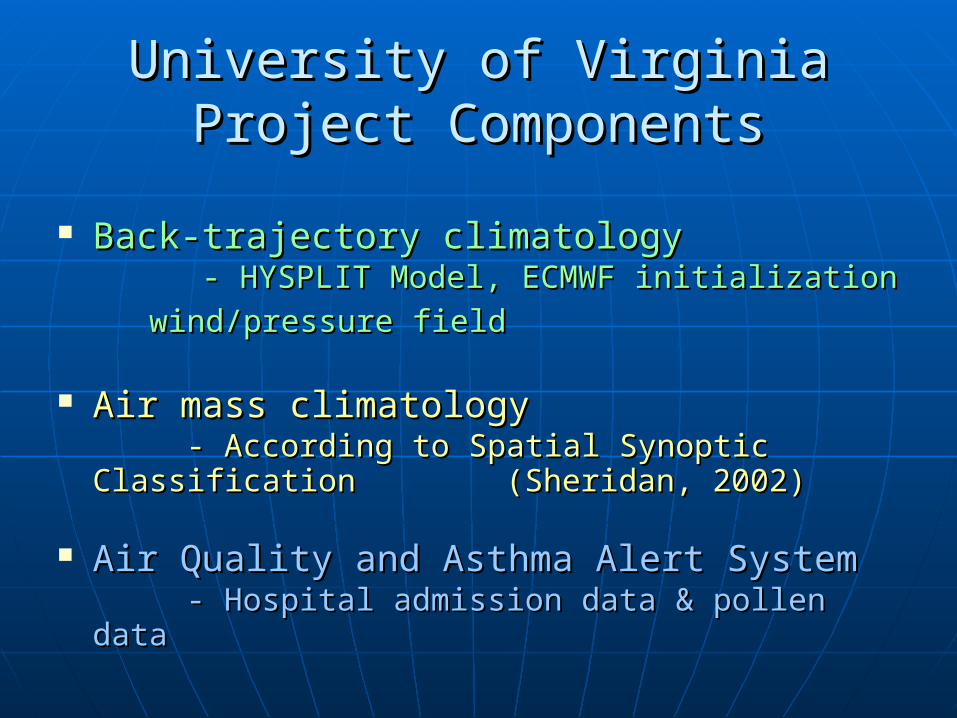
University of Virginia Project University of Virginia Project ComponentsComponents
Back-trajectory climatologyBack-trajectory climatology
- HYSPLIT Model, ECMWF initialization - HYSPLIT Model, ECMWF initialization wind/pressure field wind/pressure field
Air mass climatology Air mass climatology - According to Spatial Synoptic - According to Spatial Synoptic
Classification Classification (Sheridan, 2002) (Sheridan, 2002)
Air Quality and Asthma Alert SystemAir Quality and Asthma Alert System- Hospital admission data & pollen data- Hospital admission data & pollen data
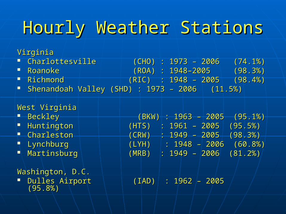
Hourly Weather StationsHourly Weather StationsVirginiaVirginia Charlottesville (CHO) : 1973 – 2006 (74.1%)Charlottesville (CHO) : 1973 – 2006 (74.1%) Roanoke (ROA) : 1948–2005 (98.3%)Roanoke (ROA) : 1948–2005 (98.3%) Richmond (RIC) : 1948 – 2005 (98.4%)Richmond (RIC) : 1948 – 2005 (98.4%) Shenandoah Valley (SHD) : 1973 – 2006 (11.5%)Shenandoah Valley (SHD) : 1973 – 2006 (11.5%)
West Virginia West Virginia Beckley (BKW) : 1963 – 2005 (95.1%)Beckley (BKW) : 1963 – 2005 (95.1%) Huntington (HTS) : 1961 – 2005 (95.5%)Huntington (HTS) : 1961 – 2005 (95.5%) Charleston (CRW) : 1949 – 2005 (98.3%)Charleston (CRW) : 1949 – 2005 (98.3%) Lynchburg (LYH) : 1948 – 2006 (60.8%)Lynchburg (LYH) : 1948 – 2006 (60.8%) Martinsburg (MRB) : 1949 – 2006 (81.2%)Martinsburg (MRB) : 1949 – 2006 (81.2%)
Washington, D.C.Washington, D.C. Dulles Airport (IAD) : 1962 – 2005 (95.8%)Dulles Airport (IAD) : 1962 – 2005 (95.8%)

Shenandoah Valley RegionShenandoah Valley RegionHourly Weather StationsHourly Weather Stations


Back-Trajectory ModelBack-Trajectory Model HYSPLIT (HYbrid Single-Particle Lagrangian Integrated HYSPLIT (HYbrid Single-Particle Lagrangian Integrated
Trajectory) Version 4.8Trajectory) Version 4.8
Downloaded from: Downloaded from: http://www.arl.noaa.gov/ready/hysplit4.htmlhttp://www.arl.noaa.gov/ready/hysplit4.html
Single or multiple (space or time) simultaneous trajectories Single or multiple (space or time) simultaneous trajectories of parcels of parcels
3D particle dispersion 3D particle dispersion
Computations forward or backward in time Computations forward or backward in time
Newer version includes improved advection algorithms Newer version includes improved advection algorithms

Back-Trajectory Data InputBack-Trajectory Data Input
ECMWF initialization wind/pressure fieldECMWF initialization wind/pressure field
ETA 80 km resolutionETA 80 km resolution
1/1/1997 - 12/31/2005 1/1/1997 - 12/31/2005
8 Shenandoah Valley first-order stations:8 Shenandoah Valley first-order stations:
VA : Lynchburg, Richmond, Roanoke, Wash. DullesVA : Lynchburg, Richmond, Roanoke, Wash. Dulles
WV: Beckley, Charleston, Huntington, MartinsburgWV: Beckley, Charleston, Huntington, Martinsburg
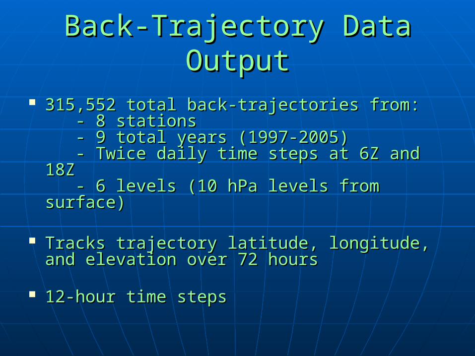
Back-Trajectory Data OutputBack-Trajectory Data Output
315,552 total back-trajectories from:315,552 total back-trajectories from: - 8 stations - 8 stations - 9 total years (1997-2005) - 9 total years (1997-2005) - Twice daily time steps at 6Z and 18Z - Twice daily time steps at 6Z and 18Z - 6 levels (10 hPa levels from surface) - 6 levels (10 hPa levels from surface)
Tracks trajectory latitude, longitude, and Tracks trajectory latitude, longitude, and elevation over 72 hours elevation over 72 hours
12-hour time steps12-hour time steps
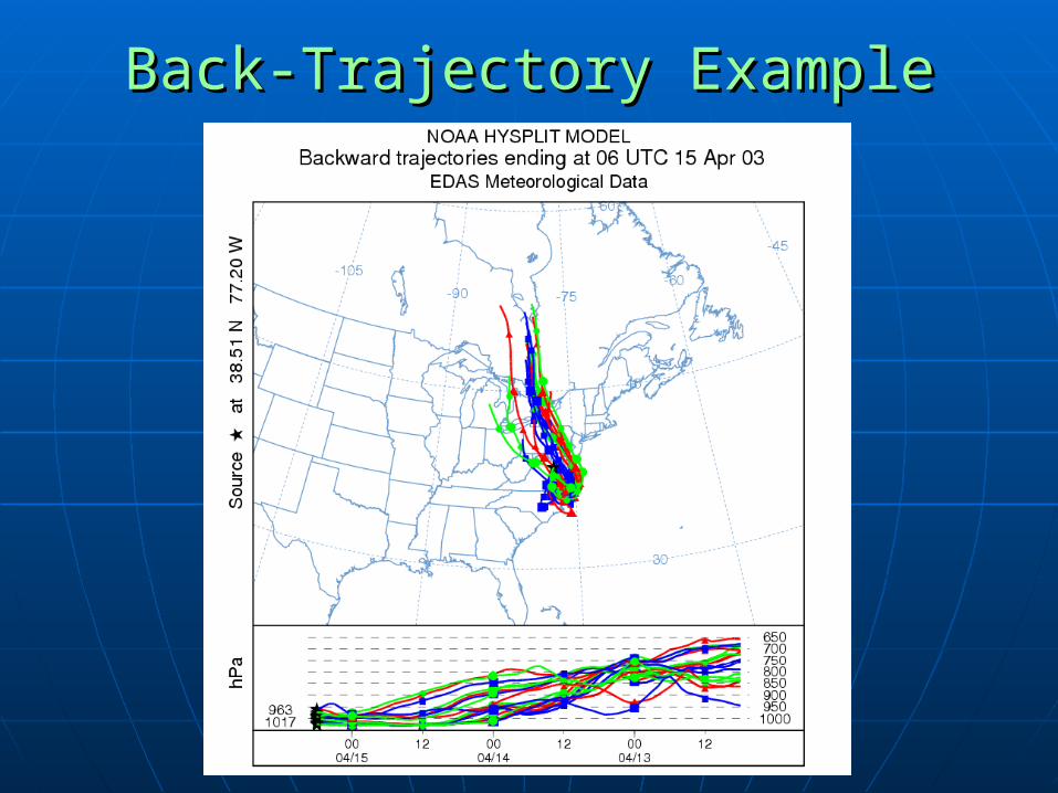
Back-Trajectory ExampleBack-Trajectory Example

Proposed Analysis of Back-Proposed Analysis of Back-TrajectoriesTrajectories
Compass directionCompass direction
Examined for Examined for seasonality, long-term seasonality, long-term trends, and spatial trends, and spatial variabilityvariability

Cluster AnalysisCluster Analysis
Desire to group back-Desire to group back-trajectories according to trajectories according to direction, transport length, direction, transport length, elevation, point of origin, elevation, point of origin, etc.etc.
Clusters examined for Clusters examined for seasonality, long-term seasonality, long-term trends, and spatial trends, and spatial variabilityvariability
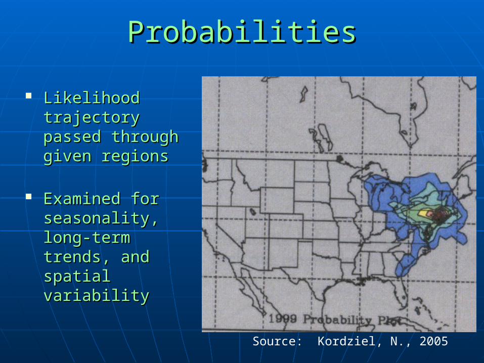
ProbabilitiesProbabilities
Likelihood Likelihood trajectory passed trajectory passed through given through given regionsregions
Examined for Examined for seasonality, long-seasonality, long-term trends, and term trends, and spatial variabilityspatial variability
Source: Kordziel, N., 2005

Development of Air Mass ClimatologyDevelopment of Air Mass Climatology
Spatial Synoptic Classification (SCC) Spatial Synoptic Classification (SCC)
Developed by Sheridan et al., 1996 and 2006Developed by Sheridan et al., 1996 and 2006
““Weather types”Weather types”

Air Mass TypesAir Mass Types1 - Dry Moderate (1 - Dry Moderate (DMDM)) - Often found in east/central - Often found in east/central U.S.U.S. - Mild conditions- Mild conditions - Air warmed/dried over Rockies- Air warmed/dried over Rockies
2 - Dry Polar (2 - Dry Polar (DPDP)) - A.k.a. Continental Polar- A.k.a. Continental Polar - Clear, cool conditions- Clear, cool conditions - Usually advected from Canada- Usually advected from Canada
3 - Dry Tropical (3 - Dry Tropical (DTDT)) - Hottest, driest conditions- Hottest, driest conditions - Advected from SW U.S. or - Advected from SW U.S. or MexicoMexico Santa Anna/Chinook windsSanta Anna/Chinook winds
4 - Moist Moderate (4 - Moist Moderate (MMMM)) - Cloudy, moist mild- Cloudy, moist mild - Frontal overruning- Frontal overruning - Typically appears south of MP- Typically appears south of MP
5 - Moist Polar (5 - Moist Polar (MPMP)) - Cloudy, humid, cool conditions- Cloudy, humid, cool conditions - Air transported inland from - Air transported inland from cool oceancool ocean - Frontal overruning well to - Frontal overruning well to southsouth
6 - Moist Tropical(6 - Moist Tropical(MTMT)) - Warm, very humid- Warm, very humid - Warm sector of frontal cyclones- Warm sector of frontal cyclones - Gulf return-flow of highs in- Gulf return-flow of highs in eastern U.S.eastern U.S.
7 - Transition (7 - Transition (TT)) - Air masses changing on- Air masses changing on given daygiven day
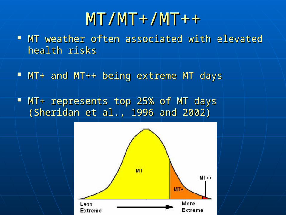
MT/MT+/MT++MT/MT+/MT++ MT weather often associated with elevated health MT weather often associated with elevated health
risks risks
MT+ and MT++ being extreme MT daysMT+ and MT++ being extreme MT days
MT+ represents top 25% of MT days (Sheridan et MT+ represents top 25% of MT days (Sheridan et al., 1996 and 2002)al., 1996 and 2002)

Time Series AnalysisTime Series Analysis
Gaps can be documented/undocumentedGaps can be documented/undocumented
Gaps arise from inhomogeneities: Gaps arise from inhomogeneities: - Change in station location, instumentation, data- Change in station location, instumentation, data acquisition, etc. acquisition, etc. - Actual climate shifts - Actual climate shifts
Employ Menne and Williams (2005) Employ Menne and Williams (2005) Likelihood Ratio Test Likelihood Ratio Test - Ratio test (to detect shift in mean)- Ratio test (to detect shift in mean) - Multi-phase regression- Multi-phase regression - Detection of multiple changepoints in a time series- Detection of multiple changepoints in a time series

Sample Air Mass ResultsSample Air Mass Results
DP frequencies:DP frequencies:
IAD SummerIAD Summer
MT frequencies:MT frequencies:
IAD SummerIAD Summer
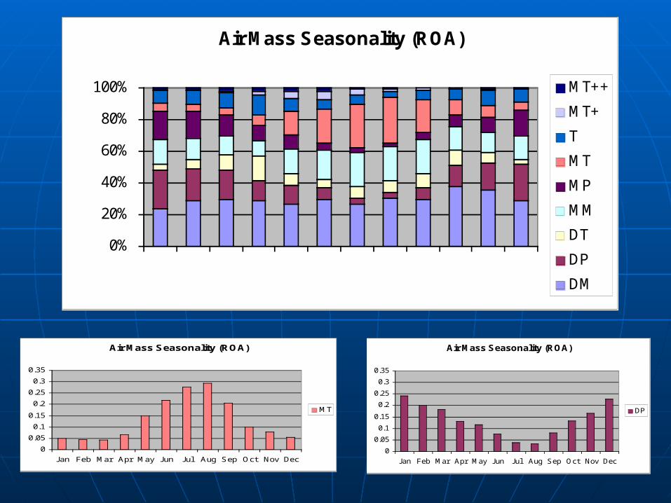
Air Mass Seasonality (ROA)
0%
20%
40%
60%
80%
100%
Jan Feb Mar Apr May Jun Jul Aug Sep Oct Nov Dec
MT++
MT+
T
MT
MP
MM
DT
DP
DM
Air Mass Seasonality (ROA)
0
0.05
0.1
0.15
0.2
0.25
0.3
0.35
Jan Feb Mar Apr May Jun Jul Aug Sep Oct Nov Dec
MT
Air Mass Seasonality (ROA)
0
0.05
0.1
0.15
0.2
0.25
0.3
0.35
Jan Feb Mar Apr May Jun Jul Aug Sep Oct Nov Dec
DP

Air Mass Seasonality (ROA)
0
0.05
0.1
0.15
0.2
0.25
0.3
0.35
Jan Feb Mar Apr May Jun Jul Aug Sep Oct Nov Dec
DP
Air Mass Seasonality (IAD)
0
0.05
0.1
0.15
0.2
0.25
0.3
0.35
Jan Feb Mar Apr May Jun Jul Aug Sep Oct Nov Dec
DP
Asthma DataAsthma Data Solucient, healthcare information provider Solucient, healthcare information provider
Patient-level data Patient-level data
UB-92 form filled out by patients during UB-92 form filled out by patients during payment for treatmentpayment for treatment
Daily admissions to all hospitals in Daily admissions to all hospitals in Shenandoah ValleyShenandoah Valley
1/1/01 – 12/31/051/1/01 – 12/31/05

Pollen DataPollen Data
Surveillance Data, Inc. (SDI)Surveillance Data, Inc. (SDI)- Aerobiological environmental - Aerobiological environmental
consulting firm (1980)consulting firm (1980)
- Supplies “Pollen.com”- Supplies “Pollen.com”
Contacted three specialized Ph.D’s Contacted three specialized Ph.D’s

Next StepsNext Steps Back-trajectories:Back-trajectories:
-Perform cluster analysis to develop -Perform cluster analysis to develop climatologyclimatology
Air mass analysis:Air mass analysis: -Apply Menne and Williams (2005) to-Apply Menne and Williams (2005) to examine datasets for trends andexamine datasets for trends and changepointschangepoints
Asthma analysis :Asthma analysis : -Begin sorting and examining asthma dataset -Begin sorting and examining asthma dataset --
Find adequate pollen dataFind adequate pollen data