serendipitous outcomes in space history: from space
TRANSCRIPT

HAL Id: hal-01758343https://hal.archives-ouvertes.fr/hal-01758343
Submitted on 12 Apr 2018
HAL is a multi-disciplinary open accessarchive for the deposit and dissemination of sci-entific research documents, whether they are pub-lished or not. The documents may come fromteaching and research institutions in France orabroad, or from public or private research centers.
L’archive ouverte pluridisciplinaire HAL, estdestinée au dépôt et à la diffusion de documentsscientifiques de niveau recherche, publiés ou non,émanant des établissements d’enseignement et derecherche français ou étrangers, des laboratoirespublics ou privés.
Serendipitous Outcomes in Space History: From SpacePhotography to Environmental Surveillance
Sebastian Grevsmühl
To cite this version:Sebastian Grevsmühl. Serendipitous Outcomes in Space History: From Space Photography to En-vironmental Surveillance. Simone Turchetti; Peder Roberts. The Surveillance Imperative, Palgrave,pp.171-191, 2014, 978-1-349-49407-1. �10.1057/9781137438744_9�. �hal-01758343�
This chapter was published in: Simone Turchetti and Peder Roberts (eds.), The Surveillance Imperative, New York: Palgrave, 2014, p.171-191
Chapter 8 Serendipitous Outcomes in Space History: From Space
Photography to Environmental Surveillance
Sebastian V. GREVSMÜHL
On February 8, 1962, the US Navy, in collaboration with the US Weather
Bureau and the Canadian government, launched a major observation effort “to
correlate observations of the ice conditions in the Gulf of St. Lawrence made
from surface ships and aircraft with those made from the TIROS [Television
Infrared Observation] satellite.”1 Observation correlation in the context of satel-
lite remote sensing meant two things. First of all, it implied learning how to look
at the images provided by the f irst meteorological satellite program in order to
use them in scientif ic studies. In order to make sense of the pictorial evidence,
these images had to be correlated with other, better know “topographies of
knowledge,”2 such as aerial photography, which had already become fully opera-
tional during World War I. Secondly, observation correlation required coopera-
tion between major Cold War military and civilian organizations, such as the
US Navy and the US Weather Bureau. Their participation thus reveals that these
correlation studies had hidden surveillance ambitions and were sponsored not
just in light of benefits to scientif ic knowledge but also because of a national
security imperative.
Historians of twentieth-century science and technology have yet to fully
explore the history of National Aeronautical and Space Administration’s (NASA)
satellite programs for environmental surveillance. Pamela Mack’s pioneering
study of the Landsat satellite project of the late 1960s and 1970s has shown that
during the Cold War satellites enabled to gain an increasingly global picture
of environmental conditions. Unfortunately, her research was not followed by
many comparable in-depth studies. Probably one of the most notable exceptions
is Erik Conway’s Atmospheric Science at NASA and, to a lesser degree, Henry
Lambright’s NASA and the Environment: The Case of Ozone Depletion.3 By con-
trast, following Ron Doel’s pioneering work, historians have covered the subject
of military patronage of Cold War environmental sciences quite extensively.4
Some scholars have examined the surveillance implications of early space photog-
raphy and satellite imagery.5 National Reconnaissance Off ice (NRO) historian
Cargill Hall contributed particularly strongly to our current understanding of
172 S EB A S T I A N V I N C EN T G R E V S M Ü H L
the close cooperation, yet also the severe tensions that existed between the NRO
and the American space agency all along the Cold War period.6 Clandestine
technology transfer from military to nominally civilian institutions was common
practice in the United States during the Cold War, as John Cloud and Dwayne
Day have shown.7
In this chapter I pay closer attention to the actual mediation processes involved
in producing novel environmental knowledge. I examine how information was
gathered and interpreted and how the conclusions were drawn. One lesson to be
taken from the following ref lections on early missile and satellite technologies is
that from the very beginning NASA managed to attract the attention of very dif-
ferent communities to the usefulness of remote environmental observations. We
also learn that remote sensing imaging proved to be a technology with a far wider
range of applications than those their inventors had in mind. For instance, V-2
photographs were conceived to understand the motion of rockets along their tra-
jectory, but they also quickly attracted the interest of geographers and especially
meteorologists who began to use the images to gain a better understanding of
environmental phenomena. In a quite similar way, images obtained with the f irst
US meteorological satellite TIROS served civilian as well as military goals. They
helped convey new information on cloud coverage and atmospheric systems that
was of interest not only to meteorologists but also to military planners, allowing
for better scheduling of photographic reconnaissance sorties. Moreover, in the
absence of clouds, the satellite images themselves could potentially reveal sensi-
tive terrain information such as snow and ice cover.
This chapter argues that the discovery that these images could be used differ-
ently from what they had been originally designed for was often “serendipitous.”8
I also show that these novel applications of remote sensing imagery marked an
important transition from their use in military research programs, devoted to
improving weapons and surveillance of enemy forces, to their utility in “environ-
mental surveillance”9 studies.
Early Space Photography and Serendipity
One of the most striking elements in early history of space photography is that
at the outset its utility was somewhat narrowly def ined and, eventually, its users
gained new insights on its potential for the advancement of environmental analy-
sis. At the time of the early postwar rocket f lights, leading scientists from both
sides of the Iron Curtain claimed that observation technologies were narrowly
conceived for operational use and “photography was rarely the main purpose of a
f light.”10 For example, early photographs obtained on V-2 f lights during the late
1940s and early 1950s at the US Army Ordnance’s White Sands Proving
Ground in New Mexico were taken in order “to acquire a better knowledge
of various motions executed by the missile in going through the upper atmo-
sphere.”11 The realization was in other words the result of serendipity, as the
rocket camera was not deliberately directed toward the Earth or its features so
as to image them, but rather toward the rocket’s trajectory in order to reveal its
path during the f light.
Various other types of instruments and detectors were also f lown to analyze
other characteristics of the missile system and its interaction with the medium

173 S E R EN D I P I T O U S O U T C O M E S I N S P A C E H I S T O R Y through which it travelled. These included devices to monitor the inf luence of
cosmic rays, disruption to telecommunications due to rocket exhaust, and other
effects due to the missile’s discharge.12 As veritable f lying laboratories, V-2 rock-
ets and especially the so-called Aerobees (the f irst large vector for atmospheric
research in the United States) were also f itted with detection devices and auto-
matic recorders. Photographic equipment was in other words only one of many
onboard sensors used to gather valuable data on the f light. However, when the
routine rocket recording operations returned a wealth of numeric data and other
material artifacts (including photographs), those scientists who had access to
them realized that these could f ind application in other research f ields. Rocket
photographs showed important features of the Earth (including its curvature
and jet streams) and could thus be reutilized in the context of meteorological
research or in studies focusing on the whole Earth.
The success of V-2, Aerobee, and Viking photography is even more remarkable
considering that most of those spectacular images were not only unexpected, but
that missile experts attempted to f ire the rockets during clear weather conditions,
in order to prevent problems during the launch and ensure the safe reception
of valuable information on the missiles’ trajectory upon the vehicle’s reentry.13
What the specialists working at White Sands initially considered a nuisance, that
is, the presence of meteorological systems in proximity of the launching site,
eventually enabled “the most spectacular use of photography in connection with
rocket research.”14 Analysts of the R AND Corporation (the think tank with
close ties to the US Air Force) were also well aware of the accidental nature of
rocket photographs, and R AND’s f irst feasibility study on meteorological satel-
lites openly acknowledged that the new information on cloud formations were
gained “from data which were not originally gathered for this purpose.”15
Photographs were not the only outcome of an operational use that eventually
found different applications. Spectrographs f lown aboard V-2s in the context of
Army Ordnance’s 1946 rocket program are another good example. They excited
not only astronomers interested in solar spectra but also meteorologists and geo-
physicists studying absorption processes in the upper atmosphere. Moreover,
the f irst solar spectrogram captured above the ozone layer provoked even broad
acclaim not only among specialists but also in the national and international
press.16 Yet, as David DeVorkin has shown, it is important to mention that this
considerable success did not rely at the time on the expertise of solar physicists
or any of the leading researchers in atmospheric physics. It was R ichard Tousey, a
National Research Laboratory (NR L) specialist in laboratory optical techniques
and the limits of vision, who designed the V-2 spectrograph. In fact, the vast
majority of US researchers engaged in upper atmosphere research were not part
of “traditional” academic communities. Trained in military laboratories during
World War II, these radio and radar engineers, technicians, and optics special-
ists aligned scientif ic research to a national security agenda by promoting novel
research with the aim of improving defense systems.17
Tousey’s instrument was in other words a component of science experiments
that, while nominally civilian, were tightly aligned to the interests of the US
armed forces in preparing for a nuclear conf lict. Improving ballistic missile tra-
jectories was an imperative in building up reliable missile systems, which was
the ultimate guiding objective of all the V-2 science experiments of the early

174 S EB A S T I A N V I N C EN T G R E V S M Ü H L
Cold War.18 One major “side effect” was the considerable gain in environmental
knowledge. Indeed, as Ron Doel has argued, it is certainly not an exaggeration
to state that the guided missile helped tremendously to “constitute the physical
environmental sciences in the US after 1945.”19
The Mobilization of the First Space Photographs in
the Context of Meteorological Research
Rocket photography had a signif icant impact in the advancement of meteorol-
ogy in the United States and helped its most prominent experts to experiment
with photographic materials blending together a variety of different techniques.
It also made them eager to promote new satellite programs for weather recon-
naissance. Already by the end of the 1940s, the White Sands rocket program
had produced spectacular photographs, including some showing the Earth’s
curvature and a variety of meteorological systems above our planet. Those pic-
tures (disseminated also via the popular press, such as in National Geographic20)
helped to promote rocket imagery well beyond military departments and to
ensure space photography became adopted in the running of other scientif ic
endeavors.21
The photographs seemed to have promise especially for meteorological
research and stimulated plans to launch a satellite mainly devoted to taking
images from space to know more about jet streams and other large-scale atmo-
spheric phenomena and processes.22 Some NASA experts were wary of this solu-
tion due to the enormous complexity of the task ahead.23 But others, such as the
meteorologist Harry Wexler (the US Weather Bureau’s observer on the panel
overseeing the V-2 program at White Sands Proving Ground), were determined
to push the scientif ic exploits to be derived from rocket experiments. Wexler was
one of several US science administrators (also including Joseph Kaplan, Lloyd
Berkner, James Van Allen, Homer Newell, and Fred Singer) who saw the devel-
opment of a satellite as critical to the advancement of meteorology in the United
States.24 Yet they succeeded only when US military agencies offered funding for
the endeavor. This was mainly because of their interest in technologies that dras-
tically improved surveillance and the planning of military operations by provid-
ing up-to-date meteorological information. Already a 1946 report by the R AND
Corporation argued for the feasibility of satellites and noted unambiguously that
“perhaps the two most important classes of observation which can be made from
such a satellite are the spotting of the points of impacts of bombs launched by us,
and the observation of weather conditions over enemy territory.”25
Aware that support existed for his plans, Wexler vigorously campaigned for
a US weather satellite. In May 1954, he presented his views to a large audience
gathered on occasion of the Third Symposium on Space Travel held at Hayden
Planetarium (New York). For the f irst time Wexler’s vision of a satellite Earth
observation program emerged and he used numerous slides of photographs “acci-
dentally” showing meteorological systems obtained with the cameras installed
on the V-2. Two years later, he presented his ideas again at the Third Annual
Conference of the American Astronautical Society. Besides a rather rudimen-
tary photographic mosaic already used during his previous speech, Wexler now
showed a remarkably sophisticated composite image, which Otto E. Berg of

175 S E R EN D I P I T O U S O U T C O M E S I N S P A C E H I S T O R Y
E
A
S
T
SO
UT
H
the Naval Research Laboratory (NR L) had pieced together with the help of
16-mm photographs obtained in October 1954 on one of the Aerobee-Hi rocket f
lights (Figure 8.1). Made out of more than 100 color photographs, enlarged
and mounted on a sphere, Berg’s composite picture was indeed an impressive
visual argument for the need of satellite-based synoptic weather observations.26
Yet the mosaic was a serendipitous outcome of NR L’s missile program and
nobody could anticipate that rocket photographs would be used for this pur-
pose. Few also believed it possible to visualize for instance a tropical storm that,
in fact, was now visible near the Gulf of Mexico in the upper left of the mosaic.
Berg’s photomontage clearly exemplif ied the enormous potential of satellite
photography for meteorological analysis. This is also the reason why the article
that Berg published together with Lester Hubert (US Weather Bureau) on the
mosaic concluded that “[t]he possibilities suggested by this accidental rocket
reconnaissance of a tropical storm are tremendous.”27 In September 1955 the
popular press celebrated Berg’s “portrait of the Earth” and a double color page
was published in the magazine Life.28 The mosaic thus generated interests in
satellite photography well beyond military circles. The serendipitous f inding that
clouds could be continuously photographed from space made Wexler even more
enthusiastic. Presumably drawing on the parlance of military personnel recon-
noitering Soviet forces, he now envisaged that a weather satellite could function
as a “storm patrol.”29
The photographic mosaic, however, also demonstrated the advantages of com-
bining different techniques of analysis of pictorial evidence consisting of com-
posing images and then treating them with a variety of meteorological methods.
Figure 8.1 Black-and-white photomontage of more than 100 individual photographs
obtained during a US Navy Aerobee f light in 1954 and mounted on a sphere by NR L scien-
tist Otto Berg. A large whirlpool of cloud left over from a tropical cyclone above the Gulf of
Mexico, discovered by chance, is visible in the upper left of the image
Source: NOAA image library.
176 S EB A S T I A N V I N C EN T G R E V S M Ü H L
The whole complexity of the synoptic weather situation, especially, as in the
case of Berg’s mosaic, due to the presence of several small vortices, proved to be
undetectable when relying solely on the standard contour analysis traditionally
employed in meteorology. Indeed, as Berg and Hubert point out in their article,
three vortices were “suff iciently small to be overlooked in the routine contour
analysis” as they were below “the detection threshold of [the] data network.”30
The data points that the meteorologists had at their disposal were in other words
still too sparse in order to be able to draw contour lines allowing to reveal the
three circular structures that were however clearly visible in Berg’s mosaic.31
Rocket photographs revealed, in other words, a whole new complexity in the
state of the atmosphere. They also helped visualize new weather systems and
patterns such as for example cyclone structures that explained in Berg’s case the
actual cause of a local high-precipitation phenomenon, as normally known from
the tropical regions, by simply visualizing their presence.32 Yet the photographs
could not represent a goal in their own right. Many elements of the photo-
graphic mosaic could only be of utility if analyzed with traditional meteorologi-
cal methods. Therefore, Berg’s recent mosaic represented a good opportunity to
correlate novel pictorial data with more traditional methods of meteorological
analysis. The example clearly shows that each visualization medium possesses its
own “epistemic limits” according to what I have called elsewhere an “epistemic
topography.”33 Rocket and satellite photographs were breaking new ground in
meteorological work mainly because they enabled the observation of large-scale
meteorological systems from above rather than below, allowing therefore a com-
plete rethinking of the global atmospheric system.
The new epistemic topography called for a new visual language.34 In 1951,
two R AND analysts, Stanley M. Greenfield and William W. Kellogg, argued in a
report for introducing a whole new method of cloud classif ication based on the
visual appearance of clouds in pictorial evidence from rockets. They also stated
that the new visual language ought to replace existing classif ication criteria,
since observing clouds from above dramatically changes shapes and patterns and
they often do not coincide with the traditional view from the ground. In other
words, the inversion of perspective and the broader, synoptic viewpoint created
fundamentally new knowledge that traditional classif ication schemes could not
produce.35 Unsurprisingly, the most experienced scientists involved in V-2 pho-
tographic analysis concluded at the time that “[t]he manner in which clouds or a
cloud formation seen from above and from below coincide is still far from being
def initely known.”36
However, by combining different types of knowledge, by (often literally)
superimposing traditional meteorological analysis and visualization of cloud
cover, it slowly became possible to identify new large-scale phenomena and to
correlate them with better-established local knowledge.37 Indeed, the example
of cloud photography shows very well the necessity of integrating different kinds
of epistemic topographies, which assisted in the development of meteorology all
through the Cold War.38
By experimenting with rocket photographs and correlating visual data with
other techniques Wexler, Berg, and other prominent US meteorologists could
set a new agenda in meteorological studies in the United States, a rationale based
on environmental surveillance. This was an agenda that, quite evidently, drew
177 S E R EN D I P I T O U S O U T C O M E S I N S P A C E H I S T O R Y
on existing Cold War challenges in terms of both method and instruments.
Methodologically, it promoted reconnaissance as a useful way to attack weather
analysis and in terms of instrumentation it advocated reusing equipment origi-
nally developed for military research purposes. Yet Wexler even envisioned the
advantages to be derived from a satellite devoted to meteorology thanks to the
assistance of a professional painter, as we shall now see.
Harry Wexler and the Invention of a First Satellite Icon
The integration of different topographies of knowledge in the f ield of meteorol-
ogy was one of Harry Wexler’s main objectives. Although enthusiastic about
Berg’s photographic mosaic, he was aware that rocket photography was far less
effective than satellite photography. In the long run, only satellite observations
of the atmosphere would allow a synoptic and continuous production of weather
data. Wexler was also aware of the great power pictures could bear on funding
institutions and decision makers. Indeed, as David DeVorkin noted, the off ices
of Wexler superior’s were always “well adorned with photographs of storms and
cloud systems taken from space.”39 In 1954 he thus sought to commission a
painting from an unknown artist who was “stimulated by such chance photos
from research rockets.”40 Also, Wexler was well placed to judge how impressive
the natural power of meteorological phenomena could be. As a former member
of the Meteorology Division in the Army Air Forces, in 1944 he actually f lew
across a hurricane that would later be famously called for its extreme violence the
“Great Atlantic Hurricane.”41
The painting ordered by Wexler shows a hypothetical view of parts of the
Earth and its atmosphere at an altitude of about 6,400 kilometers above Amarillo,
Texas. Due to its circular framing, some cultural historians have referred to the
painting as a precursor of the famous blue marble.42 Yet an observer would have
to travel at least double the distance Wexler had chosen for this hypothetical
view of the Earth’s atmosphere in order to see the curvature of planet Earth
appear in the way that it was portrayed by the Apollo astronauts.43
The painting was realized with the support of numerous new scientif ic insights,
as Wexler explained during his talk at the Third Symposium on Space Travel. On
that occasion the painting acquired a new status as a “truly scientif ic image,”
even if its evident “constructed” character strikes the contemporary observer.44
Most of the depicted weather systems were quite “realistically” anticipated and
showed a truly remarkable correspondence to high-altitude cloud photographs
as data from TIROS and other programs would reveal a few years later.45
All the elements depicted were carefully elaborated on the canvas. For exam-
ple, the continental parts of the painting are represented taking into account
“ref lectivity of sunlight” and the “scattering and depleting effects on the pas-
sage of light through the Earth’s atmosphere.”46 Furthermore, the image is
dominated by very different kinds of clouds, ranging from “a cyclone family of
three storms” to “a hurricane” and cloud streets, to which “albedo values were
assigned [ . . . ] and their brightnesses [sic] computed.”47 Yet the probability for
each of these different cloud types to appear simultaneously was low: “the trade
cumuli could undoubtedly be observed on almost any day and others, such as
the hurricane, seen only rarely.”48

178 S EB A S T I A N V I N C EN T G R E V S M Ü H L
The unknown artist, thanks to Wexler’s guidance, was thus able to unite
in one single picture the greatest possible number of different cloud types and
produce a sort of condensed cloud “atlas.” This explains Wexler’s interest in this
painting as it enabled to establish a veritable visual typology of Earth’s “atmo-
spheric systems” seen from space. Photographic naturalism, even if it had been
at Wexler’s disposition, would never have suff iced to reveal what Wexler wanted
to show to his public.49 Moreover, the choice of a perpendicular perspective—
introducing the theme of the planisphere50 —seems indispensable in underlining
Wexler’s intention to transform the sky illustrations into quantifiable and clearly
identifiable scientif ic objects, reinforcing his message that these instruments
ought soon to be built.
Throughout the 1950s and 1960s, scientists in the United States, but also
the broad public, hoped that these new technologies would one day even allow
eff icient “weather control.”51 It comes therefore as no surprise that Wexler’s
innovative understanding of weather analysis and observation also relied on the
support of military organizations to become reality. If NASA’s TIROS program
was conceived as a “storm patrol,”52 then it was also a means to a Cold War sur-
veillance end, as we shall now see.
Towards an Integration of Data: TIROS, the First
Meteorological Satellite Program
The earliest R AND report on meteorological satellite surveillance unambigu-
ously stated that “in the event of armed conflict there will be large regions of the
world from which it will be impossible to obtain weather information by normal
means. Owing to the fact that the success of any aerial reconnaissance depends,
to a large extent, on [ . . . ] knowledge of the weather conditions over the tar-
get, the lack of this information will be felt more and more as any planned air
offensive progresses. Systematic weather reconnaissance by some unconventional
means must therefore be undertaken.”53 When Wexler’s plans were examined by
prominent military agencies in the United States, what caught their attention
was not the potential of space photography for meteorological research alone,
but also for surveillance operations.
The integration of surveillance technologies, such as photographic and tele-
vision cameras, into the satellite payload seemed to have promise in terms of
boosting the capacity to reconnoiter enemy territories, and was therefore worth
signif icant investments. As a consequence, the US Air Force and the US Army f
inanced research on different satellite observation technologies.54 If military
objectives, such as improving the performance of rockets, gave leeway to devel-
oping important areas of civilian research, including the application of televi-
sion and photography to meteorological programs, then these programs offered
cover for furthering other military projects, including surveillance satellites.
Even knowledge of cloud coverage in itself provided highly relevant intelligence
information. It allowed for better coordination of traditional photographic
reconnaissance f lights, especially since cloud coverage posed a major threat to
their successful accomplishment.
It therefore made sense, at least from the US perspective, to vigorously pro-
mote free access to space to improve the ability to reconnoiter enemy territories.

179 S E R EN D I P I T O U S O U T C O M E S I N S P A C E H I S T O R Y
The International Geophysical Year scientif ic satellite program provided there-
fore the historical and legal basis for what Cargill Hall rightly identif ied as “a
stalking horse to establish the precedent of overf light in space for the eventual
operation of military reconnaissance satellites.”55 Indeed, as Walter McDougall
has shown and as Roger Launius argues in his contribution to this book, US
presidents Dwight D. Eisenhower and John F. Kennedy clearly understood
the multiple benef its to be derived from granting free access to outer space.
Eisenhower’s controversial “Open Skies” proposal and Kennedy’s plea for
“peaceful uses of outer space” both aimed to defuse any possible objections
against satellite reconnaissance.56
In the f ield of meteorology, the off icial and well-known outcome of this strat-
egy was the initiation under the Kennedy administration of discussions with the
Soviet Union on a joint meteorological satellite program, united under the aegis of
the World Meteorological Organization. Approved in 1963 as the World Weather
Watch and still in operation today, the program, with its subsystems, coordinates
meteorological observation efforts to provide weather services in all countries.57
However, the free access to space policy also served military reconnaissance
and surveillance interests. Many scientif ic satellite programs, some similar to
TIROS, offered cover for spy missions. For example, NASA’s Discoverer pro-
gram—officially announced to the public as a research program dedicated to
examining and reporting on the space environment, including most notably bio-
medical experiments with mice and monkeys—carried as its main payload the f
irst US photoreconnaissance satellite camera system used as part of the highly
classif ied CORONA program.58 Also, in the 1960s meteorological research satel-
lites were routinely used as cover for military surveillance. For instance, between
1962 and 1994 the US Air Force Defense Meteorological Satellite Program
(DMSP) deployed a whole set of meteorological satellites, largely identical to
their civil counterparts of the TIROS program.59
The TIROS meteorological satellites were themselves born out of a surveil-
lance satellite program. TIROS had an immediate military precursor known as
US Army project Janus that was initially conceived as a reconnaissance project
developed for spying on Soviet territory.60 The imaging technology was based
on a study from the Radio Corporation of America (RCA), a proposal initially
presented to the US Air Force for their secret reconnaissance program known as
WS-117L. After the bid was lost to Lockheed, RCA sold the idea to the Army
where the work was developed further. Shortly after the NASA was created, the
program (then known as Janus 2) was transferred in April 1959 to the Space
Agency and renamed TIROS. Within the TIROS program, NASA obtained the
overall responsibility for engineering and launch and the US Weather Bureau
had to oversee operation and data interpretation.61
This transfer to nominally civilian institutions is generally considered the
beginning of a clear separation of military and civilian programs. Yet the TIROS
program shows that throughout the Cold War, this distinction is highly ambig-
uous, if not to say artif icial. Indeed, a closer look at Cold War meteorology
efforts erodes our confidence in the distinction between nominally military and
nominally civilian uses. Despite important achievements of the DMSP, for exam-
ple during the Cuban missile crisis in 1962, the Department of Defense also
continued to make use of TIROS imagery. In fact, in order to fully assure DoD’s
180 S EB A S T I A N V I N C EN T G R E V S M Ü H L
need for an operational weather satellite, TIROS’s two read-out sites at Fort
Monmouth and on Hawaii were permanently staffed with “teams composed of
meteorologists from the Weather Bureau and Department of Defense agencies”
and a “Navy meteorologist was stationed at Ft. Monmouth during the entire
operational period of TIROS I.”62 For the same purpose, as documented by the
agreement that off icially transferred the program to NASA, a joint DoD-NASA
advisory group was put in place and substantial DoD funding allocated to the
program in order to assure full cooperation.63
In terms of technology, it is true that the TIROS meteorological satellites
had relatively low-resolution central reconnaissance components because of the
civilian use NASA was supposed to make of them.64 But TIROS’s reduced res-
olution enabled more information to be gained than expected. Both satellite
cameras produced black-and-white images composed of distinct lines, making
the contrast of the vidicon images one of their most important criteria.65 The
imaging technology was designed to better identify and visualize meteorologi-
cal systems, but once the f irst satellite was operational other Earth features also
became discernable.
This is a recurrent theme in the history of remote sensing: observation tech-
nologies produce a “surplus” of information, something not anticipated when
they were designed. Following the reception of the f irst TIROS images, sci-
entists started to become interested in phenomena that had little to do with
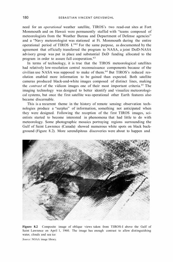
meteorology. Some photographic mosaics portraying regions surrounding the
Gulf of Saint Lawrence (Canada) showed numerous white spots on black back-
ground (Figure 8.2). More serendipitous discoveries were about to happen and
Figure 8.2 Composite image of oblique views taken from TIROS-I above the Gulf of
Saint Lawrence on April 1, 1960. The image has enough contrast to allow distinguishing
water, clouds and sea ice
Source: NOAA image library.

181 S E R EN D I P I T O U S O U T C O M E S I N S P A C E H I S T O R Y
Harry Wexler eventually concluded that those white spots could be sea ice.66 So
in the 1960s, Wexler supervised a group of scientists at the US Weather Bureau
that investigated in greater depth ice surveillance techniques—an application
that touched upon, as I will show now, military, scientif ic, political, as well as
economic questions.67
TIREC: Environmental Satellite Surveillance
during the Cold War
The accidental reconnaissance of sea ice through a satellite designed to produce
pictures of clouds eventually led to project TIR EC. Launched in 1962 project
TIR EC aimed “to correlate observations of the ice conditions in the Gulf of
Saint Lawrence made from surface ships and aircraft with those made from the
TIROS satellite.”68 TIR EC, an acronym for TIROS Ice Reconnaissance, had as
main objective the development of “procedures and techniques for interpreting
satellite readouts of ice formation.”69 It was in many ways an unforeseen by-
product of the f irst American weather satellite program, a serendipitous appli-
cation of remote cloud observation, initially not included in the list of possible
weather satellite uses.
At the end of the f irst two experimental phases, TIR EC confirmed, even
without a ref ined resolution, what Wexler had foreseen. It proved indeed pos-
sible to distinguish clouds from ice and to produce maps of sea ice. The com-
parison of images taken at different times as well as their geometric correction
(for example, image distortion resulting from the lens of the camera had to be
corrected) helped in achieving this task.
“Measurement of ice and snow cover,” as a report to the US Congress in
1962 deliberately vaguely put it, had indeed “also [ . . . ] a military application.”70
Lavishly endowed with military funding, TIR EC eventually helped to more f
irmly establish environmental surveillance as a way to establish control over
polar regions. Sea ice maps obtained through correlation of satellite data allowed
for improved coordination of military and scientif ic logistics in the cold regions.
They also granted otherwise unavailable information on access to strategic sites
via polar transit areas. As one representative of the Canadian Defense Board
noted, sea ice observations were especially important to identify places where
submarines may emerge.71
Ice observations were also of “direct economic interest,” a major motiva-
tion for putting TIR EC in place.72 In a study on the nonmeteorological uses
of TIROS and the Nimbus satellite programs, Fred Singer (better known today
for his global warming skeptic declarations73) argued that meteorological sat-
ellites could have saved Canadian and US administrations, for the year 1961
alone, no less than $1.7 million traditionally put aside for logistical operations
and the planning of navigable waterways, a f igure geologist and geophysicist
Paul Lowman of Goddard Space Flight Center rightly considered “mislead-
ingly conservative” as further savings could be derived from using the same
system in Western Europe, Russia, and especially Antarctica.74 TIROS data also
offered invaluable support to the US Navy in Antarctic exploration and helped
to strengthen its role as principal logistics operator at the South Pole.75

182 S EB A S T I A N V I N C EN T G R E V S M Ü H L
Climate scientists benefitted from satellite-based ice observations and correla-
tion studies too. These proved decisive in establishing local temperature trends
(most notably warming trends), as well as water circulation estimates, all factors
that became important elements of modern climate change interpretations and
predictions.76 For example, synoptic ice observations allowed revealing that the
Antarctic continent doubles its size each winter, growing well beyond Europe’s
surface area by attaining about 34 million square kilometers thanks to the accumu-
lation of sea ice. Indeed, from the 1960s onward, sea ice accumulation as inferred
from satellite images has been routinely used to assess global climatic changes.77
Thus Project TIR EC pioneered Cold War environmental surveillance.
The reasons behind its development were not just scientif ic. Economic, logis-
tic, strategic, and geopolitical ambitions were equally relevant.78 Soon after
Project TIR EC was established, a conference on satellite ice studies was held
in Washington, DC. By looking at the agencies and institutions represented,
one understands how important these studies had now become to civilian and
military organizations alike. Representatives of Canada’s Defence Research
Board and its Joint Photographic Intelligence Center, together with the Royal
Canadian Air Force were present. Among participants from the United States,
the Weather Bureau, NASA, the Department of Transport, and the National
Science Foundation (US Antarctic Program) had all sent delegates. Among the
51 participants, only four can be identif ied as coming from universities and not
holding any off icial military accreditation.79 These numbers show very well that
at the very beginning of satellite ice observations—they coincide practically with
the very birth of the f irst meteorological satellite program—military concerns
clearly went hand in hand with scientif ic and economic interests.
Conclusion
We should think of the example of space photography as shedding new light on
how military patronage made it possible to realize the inner surveillance poten-
tial of a range of imaging technologies—a potential that was not foreseen when
photographic cameras were f irst installed on rockets.
In order to understand the history of satellite imagery we need to recon-
sider the importance that accidental discoveries played in key moments of its
unfolding. The use of satellite photography for meteorological purposes was
the unintended outcome of attempts to monitor the path of ballistic missiles
during their f light. The application of satellite cameras to monitor sea ice was
also unforeseen, as photographs produced to “patrol” storms eventually cap-
tured more details than expected; including sea ice formations. Thus serendipity
proved to be a crucial heuristic element in the contemporary analysis of earth
features such as clouds and polar ice caps. Numerous case studies in history of
science have shown the diverse ways in which instruments and technologies may f
ind new uses, most notably through the exploitation, by chance, of some of
their “hidden” characteristics and properties. Turchetti et al. went a step further
and showed in their case study on radio echo-sounding in Antarctica that “when
accidents and errors become the subject of scientif ic enquiry, they can instigate
a broader analysis of the range of applications associated with the experimental
apparatus in use and in turn favor its adoption more remotely from its cur-

183 S E R EN D I P I T O U S O U T C O M E S I N S P A C E H I S T O R Y
rent domain.”80 Project TIR EC similarly shows that beyond simple exploitation
of hidden properties, systematic analysis of environmental surveillance imagery
favored its adoption in other scientif ic domains.
Closely linked to this accidental discovery is the importance of material cul-
ture linked to the f irst meteorological satellite program at the beginning of the
1960s. The particularities of the visualization technology, most notably the poor
resolution depending directly on the visual contrast, largely guided the use of
satellite images. Within the context of the Cold War, this meant that a “civilian”
observation technology, as soon as it aroused interest from the military, could
more easily attract important funding, favoring the production of environmental
knowledge with immediate utility for national security.
However, the adoption of the new remote sensing techniques that accidental f
indings enabled required much more than just serendipity. The military spon-
sorship of new projects such as TIROS and TIR EC made it possible to realize
what accidents had proven just as a possibility but needed substantial funding to
show its real potential. This chapter has shown that support was given in light
of the benef its to surveillance and military operations to be derived from satel-
lite imagery. The synoptic view of the satellite could easily help decide whether
aerial reconnaissance sorties over enemy territory would be eff icient or not. Yet
there was also a more generally added value of satellite photography in allowing
assessments to be made about accessibility to sea ice covered areas, controlling
navigable waterways and identifying regions which could be potentially used as
hideout for enemy submersibles. So while the opportunity existed to explore
what was serendipitously found through space photography, it was the Cold War
urgency of improved surveillance that enabled to further explore the potential of
these accidental discoveries. New knowledge of key earth features thus emerged
in the search of more sophisticated methods to know about enemy forces.
Moreover the TIR EC project shows that NASA was also actively engaged
in environmental surveillance and continued to pursue it for several years after
TIR EC reached completion. For instance, photographs from the Mercury and
Gemini space missions attracted great interest from a number of experts working
on a number of different scientif ic disciplines. In particular, during the 1960s,
geographers, geologists, and hydrologists took advantage of the new possibilities
that remote sensing offered them and used space photography in a variety of proj-
ects favoring, for instance, a more systematic monitoring of natural resources.
Oceanographers also prof ited from imagery produced during space programs, as
in the case of TIROS, prof iting from the growing spectrum of new technologies
for environmental exploration and surveillance.81 Indeed, it is not an exaggera-
tion to suggest that the interest that space photography generated was a decisive
factor in the adoption of satellite-based environmental remote sensing techniques
in the 1970s, including those aimed to more accurately ascertain the availability
of natural resources and vital aspects of global environmental change.82
Notes
1. Abraham Schnapf, “The TIROS Global System,” Annals of the New York
Academy of Sciences 134 (1965): 149–166, citation 156.
2. Sebastian Vincent Grevsmühl, “Epistemische Topograf ien. Fotograf ische und
radartechnische Wahrnehmungsräume,” in Ingeborg Reichle, Steffen Siegel,
184 S EB A S T I A N V I N C EN T G R E V S M Ü H L
Achim Spelten (eds.), Verwandte Bilder. Die Fragen der Bildwissenschaft (Berlin:
Kadmos, 2007), 263–279.
3. Pamela E. Mack, Viewing the Earth: The Social Construction of the Landsat
Satellite System (Cambridge, M A: MIT Press, 1990); Erik M. Conway,
Atmospheric Science at NASA: A History (Baltimore: Johns Hopkins University
Press, 2008); W. Henry Lambright, NASA and the Environment: The Case of
Ozone Depletion (Washington, DC: NASA, 2005). See also: Pamela E. Mack and
Ray A. Williamson, “Observing the Earth from Space,” in John M. Logsdon
(ed.), Exploring the Unknown: Selected Documents in the History of the U.S. Civil
Space Program, Vol.III: Using Space (Washington, DC: NASA, 1998), 155–177;
John H. McElroy and Ray A. Williamson, “The Evolution of Earth Science
Research from Space: NASA’s Earth Observing System,” in John M. Logsdon,
Stephen J. Garber, Roger D. Launius, and Ray A. Williamson (eds.), Exploring
the Unknown: Selected Documents in the History of the U.S. Civil Space Program,
Vol.VI: Space and Earth Science (Washington, DC: NASA, 2004), 441– 473,
and f inally Erik M. Conway, “Drowning in Data: Satellite Oceanography and
Information Overload in the Earth Sciences,” Historical Studies in the Physical
and Biological Sciences 37 (2006): 127–151.
4. See among others: Ronald E. Doel, “Constituting the Postwar Earth Sciences:
The Military’s Inf luence on the Environmental Sciences in the USA After 1945,”
Social Studies of Science 33 (2003): 635– 666. See in the same issue: Kai-Henrik
Barth, “The Politics of Seismology: Nuclear Testing, Arms Control and the
Transformation of a Discipline,” Social Studies of Science 33 (2003): 743–781.
Jacob D. Hamblin, Oceanographers and the Cold War: The Disciples of Marine
Science (Seattle: University of Washington Press, 2005); Jacob D. Hamblin,
Arming Mother Nature: The Birth of Catastrophic Environmentalism (Oxford:
Oxford University Press, 2013); John Cloud and Keith C. Clarke, “Through
a Shutter Darkly: The Tangled Relationships Between Civilian, Military, and
Intelligence Remote Sensing in the Early U.S. Space Program,” in Judith Repps
(ed.), Secrecy and Knowledge Production, Peace Studies Program Occasional
Paper no. 23 (Ithaca: Cornell University, 1999), 36 –56; John G. Cloud,
“American Cartographic Transformations During the Cold War,” Cartography
and Geographic Information Science 29 (2002): 261–282; Simone Turchetti,
Katrina Dean, Simon Naylor and Martin Siegert, “Accidents and Opportunities:
A History of the Radio Echo-Sounding of Antarctica, 1958–79,” British Journal
of the History of Science 41 (2008): 417– 444.
5. I adopt here a common, although arbitrary def inition of “space imagery,” which
postulates that any activity above 100 kilometers altitude may be considered an
(outer) space activity. Early V-2 f lights (launched around 1947) went beyond 100
kilometers altitude and may be counted therefore amongst the f irst space activity.
For this common def inition, see for example: A lain Dupas, La nouvelle conquête
spatiale (Paris: Odile Jacob, 2010), 95.
6. See for example: R. Cargill Hall, A History of the Military Polar Orbiting
Meteorological Satellite Program (Chantilly, VA: NRO Off ice of the Historian,
2001); R. Cargill Hall, “Origins of U.S. Space Policy: Eisenhower, Open Skies,
and Freedom of Space,” in John Logsdon et al. (eds.), Exploring the Unknown:
Selected Documents in the History of the U.S. Civil Space Program, Vol.I: Organizing
for Exploration (Washington, DC: NASA History Division, 1995), 213–229.
7. For example, NRO reconnaissance technology was secretly transferred to NASA’s
Lunar Orbiter program and the US Geological Survey acquired both CORONA
photography and technologies to best use the photography for mapping purposes.
See especially: John Cloud, Hidden in Plain Sight: CORONA and the Clandestine
185 S E R EN D I P I T O U S O U T C O M E S I N S P A C E H I S T O R Y
Geography of the Cold War, PhD diss. (Santa Barbara: University of California,
1999), 256 –264; R. Cargill Hall, SAMOS to the Moon: The Clandestine Transfer
of Reconnaissance Technology Between Government Agencies (Chantilly, VA: NRO
Off ice of the Historian, 2001); Dwayne A. Day, “Mapping the Dark Side of the
World, Part 1: The K H-5 A RGON Geodetic Satellite,” Spacef light 40 (1998):
264 –269; Dwayne A. Day, “Mapping the Dark Side of the World, Part 2: Secret
Geodetic Programmes After A RGON,” Spacef light 40 (1998): 303–310.
8. “Serendipity” refers to the process of accidental discovery in science. In many
cases, research questions are oriented toward other goals and uses than those that
the actual discovery reveals. See for example: Robert K. Merton and Elinor Barber,
The Travels and Adventures of Serendipity: A Study in Sociological Semantics and
the Sociology of Science (Princeton: Princeton University Press, 2004); Royston
Roberts, Serendipity: Accidental Discoveries in Science (New York: Wiley, 1989).
9. The notion “environmental surveillance” refers to all observation, measurement,
and detection technologies, which allow to describe on a more or less global-scale
environmental phenomena.
10. See on this point: B.V. Vinogradov, “Kosmicheskaya fotograf iya dlya geogra- f
icheskogo izucheniya Zemli,” Izvestiya Vsesoyuznogo Geograficheskogo Obshchestva
98 (1966): 101–111; translation (by NASA): B.V. Vinogradov, Space Photography
for the Geographical Study of the Earth, NASA TT-F-10246 (Washington, DC:
NASA, 1966). The citation is from the Anglo-Canadian geographer Brian
Bird: J. Brian Bird and A. Morrison, “Space Photography and Its Geographical
Applications,” Geographical Review 54 (1964): 463– 486, citation 468.
11. Thor Bergstralh, “Photography from the V-2 at A ltitudes Ranging up to 160
K ilometers,” in Homer E. Newell and Joseph W. Siry (eds.), Upper Atmosphere
Research Report no. IV, NR L report R-3171 (Washington, DC: Naval Research
Laboratory, 1947), 119–130, citation 119; Bergstralh’s chapter is a reprint of a
report that was published beforehand individually as NR L report R-3083, 1947.
12. David DeVorkin cites a large range of applications in his excellent book: David
DeVorkin, Science with a Vengeance: How the Military Created the US Space
Sciences After World War II (New York: Springer, 1992). A few NR L (Naval
Research Laboratory) reports document also very well those efforts; one in par-
ticular will be discussed later.
13. A good overview is given by Homer Newell in his chapter on “High-altitude
Photography,” in Homer E. Newell, High Altitude Rocket Research (New York:
Academy Press, 1953), 283–288, especially 283–284. See also: Robert Poole,
Earthrise: How Man First Saw the Earth (New Haven, CT: Yale University Press,
2008), 64.
14. Newell, High Altitude Rocket Research, 283.
15. Stanley M. Greenf ield and William W. Kellogg, Inquiry Into the Feasibility of
Weather Reconnaissance From a Satellite Vehicle, report no. R-365 (Santa Monica:
R A ND Corporation, 1951), 14.
16. The Washington Post reproduced two of the spectrograms on its front page of its
October 30, 1946, issue. Other newspapers adopted enthusiastically the story,
see: DeVorkin, Science with a Vengeance, 143–144.
17. DeVorkin, Science with a Vengeance, 1– 6.
18. See: ibid., especially Chapter 9. See also: Ronald E. Doel, “Quelle place pour les
sciences de l’environnement physique dans l’histoire environnementale,” Revue
d’histoire moderne et contemporaine 56 (2009): 137–164, here 149.
19. Ronald E. Doel, “Constituting the Postwar Earth Sciences: The Military’s
Inf luence on the Environmental Sciences in the USA After 1945,” Social Studies
of Science 33 (2003): 635– 666, here 638.

186 S EB A S T I A N V I N C EN T G R E V S M Ü H L
20. See: Ryan Edgington, “An ‘A ll-seeing Flying Eye’: V-2 Rockets and the Promises
of Earth Photography,” History and Technology 28 (2012): 363–371.
21. Meteorological analysis derived from rocket imagery, illustrated by V-2 pho-
tographs, was f irst suggested by USA F meteorologist D. L. Crowson, “Cloud
Observations From Rockets,” Bulletin of the American Meteorological Society
(1949): 17–22.
22. Jet stream analysis became next to cyclone tracking one of the major applica-
tion f ields. For an example of visual jet stream analysis, see: US Navy, Weather
Analysis from Satellite Observations (Norfolk: Navy Weather Research Facility,
1960), 30 –31.
23. See: Pamela E. Mack and Ray A. Williamson, “Observing the Earth from Space,”
in Logsdon, Exploring the Unknown Vol.III, 155–177, here 156.
24. See on this point in more detail especially: Roger D. Launius, “What Are Turning
Points in History, and What Were They for the Space Age?” in Steven J. Dick and
Roger D. Launius (eds.), Societal Impact of Spacef light (Washington, DC: NASA
History Division, 2007), 19–39, here 31.
25. Douglas A ircraft Company, Preliminary Design of an Experimental World-
Circling Spaceship, report no. SM-11827 (Santa Monica: Douglas A ircraft
Company, 1946), 11.
26. The original color photomontage is today part of the National A ir and Space
Museum collection, NASM object A19620042000. For a short description
and black-and-white reproduction of the mosaic, see also: Edgar M. Cortright,
Exploring Space with a Camera (Washington, DC: NASA, 1968), 4 –5.
27. For a detailed description, see: Lester F. Hubert and Otto Berg, “A Rocket
Portrait of a Tropical Storm,” Monthly Weather Review 83 (1955): 119–124.
28. See: Anon., “A 100 Mile High Portrait of Earth,” Life Magazine 39 (5 September
1955), 10 –11.
29. See: Harry Wexler, “Observing the Weather from a Satellite Vehicle,” Journal of
the British Interplanetary Society 7 (1954): 269–276, citation 269. The photo-
graphic mosaic also appeared in publications of the US Weather Bureau, promot-
ing the use of satellite vehicles in meteorology. See for example: US Department of
Commerce Weather Bureau, Meteorological Satellites — Global Weather Observers
(Washington, DC: Department of Commerce, 1959).
30. Hubert and Berg, “A Rocket Portrait of a Tropical Storm,” 122.
31. Contouring, in the atmospheric sciences jargon, means connecting data points
of equal value. In general, contour analysis allows to understand how different
geophysical variables change in time and space.
32. See: Hubert and Berg, “A Rocket Portrait of a Tropical Storm,” 122.
33. The notion refers to the nature of instrumental logic which is proper to each visu-
alization technology. Each visualization technology allows to see the world in a
different way and it produces therefore knowledge that is specif ic to the instru-
mentation mobilized. See on this point in more detail: Grevsmühl, “Epistemische
Topograf ien,” 263–279.
34. Martin Rudwick was among the f irst historians who insisted on the importance
of a common visual language in the making of a scientf ic discipline, which was
in his case geology around 1830, see: Martin Rudwick, “The Emergence of a
Visual Language for Geological Science 1760 –1840,” in Martin Rudwick (ed.),
The New Science of Geology: Studies in the Earth Sciences in the Age of Revolution
(A ldershot, Burlington: Ashgate, 2004 [1976]), 149–195.
35. Greenf ield and Kellogg, Inquiry Into the Feasibility of Weather Reconnaissance, 22.
R ichard Hamblyn has shown how Luke Howard introduce in England, in 1802, the
vocabulary (which became general standard) to describe clouds mostly in function

187 S E R EN D I P I T O U S O U T C O M E S I N S P A C E H I S T O R Y
of their appearance—as seen from the ground—and altitude: R ichard Hamblyn,
The Invention of Clouds: How An Amateur Meteorologist Forged the Language of
the Sky (London: Picador, 2001). However, a new descriptive section concerning
specif ically cloud classif ication as seen from above was included only in 1975 in
the standard atlas meteorologist use. The photographic volume accompanying the f
irst, descriptive volume took even longer to prepare—it appeared only in 1987:
World Meteorological Organization, International Cloud Atlas: Manual on the
Observation of Clouds and Other Meteors, WMO-no. 407, vol. 1 (text), vol. 2 (pho-
tographs) (Geneva: WMO, 1987 [1975]). Howard’s classif ication system remains
the main standard for small-scale phenomena. Leopold K letter mentions some of
the new cloud types which may only be observed from a satellite: Leopold K letter,
“Die praktische Auswertung der Bildsendungen der Wettersatelliten,” Schriften des
Vereins zur Verbreitung naturwissenschaftlicher Kenntnisse 110 (1970): 23–35.
36. This point is discussed in more detail, well before the launch of TIROS, in:
William K. Widger and Chan N. Touart, “Utilization of Satellite Observations
in Weather Analysis and Forecasting,” Bulletin of the American Meteorological
Society 38 (1957): 521–533.
37. For a typical example of a mosaic of TIROS photographs superimposed upon
surface analysis and compared with conventional analysis, see: US Navy, Weather
Analysis from Satellite Observations, 44.
38. The question of integration is for example discussed in more detail in a historical
perspective in: Amy Dahan, “Putting the Earth System in a Numerical Box? The
Evolution from Climate Modeling toward Global Change,” Studies in History
and Philosophy of Modern Physics 41 (2010): 282–292. Today, the high level of
integration, which was put into place in climatology, meteorology’s complemen-
tary discipline, is seen with quite some reticence.
39. DeVorkin, Science with a Vengeance, 145.
40. Harry Wexler, “The Satellite and Meteorology,” Technical Session Preprints of the
American Astronautical Society, Preprint no. 104254 (1956): 1–15, citation 8. On
the painting, see especially the important work of Jim Fleming: James R. Fleming,
“A 1954 Color Painting of Weather Systems as Viewed From a Future Satellite,”
Bulleting of the American Meteorological Society 88 (2007): 1525–1527; James
R. Fleming, “Earth Observations from Space: Achievements, Challenges, and
Realities,” in Steven J. Dick (ed.), NASA’s First Fifty Years: Historical Perspectives
(Washington, DC: NASA History Division, 2010), 543–562, especially 548–
549; James R. Fleming, “Polar and Global Meteorology in the Career of Harry
Wexler,” in James R. Fleming, Roger D. Launius and David H. DeVorkin (eds.),
Globalizing Polar Science: Reconsidering the International Polar and Geophysical
Years (New York: Palgrave, 2010), 225–241, here 232. Wexler’s color painting
is also discussed in: P. K rishna Rao, Evolution of the Weather Satellite Program
in the U.S. Department of Commerce—A Brief Outline, NOA A technical report
NESDIS 101 (Washington, DC: Department of Commerce, NOA A, 2001), 8.
41. For biographical information on Wexler, I refer to Wexler’s f ile in the archives of
the International Geophysical Year: National Academy of Sciences, Archives of
the IGY, “Series 13: IGY Personnel—Antarctic: Wexler, Harry, 1955–1957.”
42. A lexander Linke and Dominique Rudin, “The Earth as Seen from Apollo 8 in
Space,” Rheinsprung 11: Zeitschrift für Bildkritik 1 (2011): 147–156.
43. Robert Poole traces this history in great detail in: Robert Poole, Earthrise: How
Man First Saw the Earth (New Haven: Yale University Press, 2008).
44. See: Wexler, “Observing the Weather from a Satellite Vehicle,” 269–276. The
painting is reproduced as supporting document at the end of chapter 2 in:
Logsdon, Exploring the Unknown Vol.III, 177–183.
188 S EB A S T I A N V I N C EN T G R E V S M Ü H L
45. William K. Widger, “Satellite Meteorology—Fancy and Fact,” Weather 16 (1961):
47–55.
46. Wexler, “The Satellite and Meteorology,” 10.
47. Ibid., 10.
48. Ibid., 12.
49. The scientif ic painting is therefore part of a larger historical development that
may be observed all along the age of mechanical objectivity in which the principal
function of the painting could only survive in scientif ic niches where classif i-
cation and typology were indispensable; see: Peter Galison, “Judgment against
Objectivity,” in Caroline Jones and Peter Galison (eds.), Picturing Science,
Producing Art (New York, London: Routledge, 1998), 327–359.
50. The term planisphere refers to the map-like view of the Earth as a result of the
convergence of photography and f light during the ninteenth century, as put into
pratice by early balloonists-photographers such as Nadar. The initial objective of
Nadar’s perpendicular photography was to elaborate maps, one of two common
meanings of the term planisphere. See on this point in more detail: Sebastian
Grevsmühl, La Terre vue d’en haut: l’invention de l’environnement global (Paris:
Seuil, 2014); Sebastian Grevsmühl, A la recherche de l’environnement global: De
l’Antarctique à l’Espace et retour, PhD thesis in history of science (Paris: Ecole des
Hautes Etudes en Sciences Sociales, 2012), 240 –243.
51. Weather control was until the early 1970s a central theme in meteorology, see
for example: Jacob Hamblin, Arming Mother Nature: The Birth of Catastrophic
Environmentalism (New York: Oxford University Press, 2013); James R. Fleming,
Fixing the Sky. The Checkered History of Weather and Climate Control (New York:
Columbia University Press, 2010); Chunglin Kwa, “The R ise and Fall of Weather
Modif ication: Changes in American Attitudes toward Technology, Nature, and
Society,” in Clark A. Miller and Paul N. Edwards (eds.), Changing the Atmosphere:
Expert Knowledge and Environmental Governance (Cambridge, M A: MIT Press,
2001), 135–165.
52. Wexler, “Observing the Weather from a Satellite Vehicle,” 269. Especially
TIROS-III, launched during the US hurrican season, would acquire that reputa-
tion: Leopold K letter, “Meteorologische Satelliten erforschen das Weltwetter,”
Schriften des Vereins zur Verbreitung naturwissenschaftlicher Kenntnisse 103
(1963): 1–17, here 7.
53. Greenf ield and Kellogg, Inquiry Into the Feasibility of Weather Reconnaissance, 1.
See also: Hall, A History of the Military Polar Orbiting Meteorological Satellite
Program as well as: Stephen B. Johnson, “The Political Economy of Spacef light,”
in Steven J. Dick and Roger D. Launius (eds.), Societal Impact of Spacef light
(Washington, DC: NASA History Division, 2007), 141–191, especially 171.
54. Merton E. Davies and William R. Harris, RAND’s Role in the Evolution of
Balloon and Satellite Observation Systems and Related U.S. Space Technology,
R A ND report R-3692-RC (Santa Monica: R A ND Corporation, 1988), 23. A
detailed description of the historical dynamics between government bodies and
the different military members can be found in: Hall, “Origins of U.S. Space
Policy,” 213–229. See also: Dwayne A. Day, “Invitation to Struggle: The History
of Civilian-Military Relations in Space,” in John M. Logsdon (ed.), Exploring the
Unknown: Selected Documents in the History of the U.S. Civilian Space Program.
Vol.II: External Relationships, NASA SP-4407 (Washington, DC: NASA, 1996),
233–270.
55. Hall, “Origins of U.S. Space Policy,” 222.
56. Walter A. McDougall, The Heavens and the Earth: A Political History of the
Space Age (New York: Basic Books, 1985), 117–118, 349–352. See also: Paul N.

189 S E R EN D I P I T O U S O U T C O M E S I N S P A C E H I S T O R Y
Edwards, “Meteorology as Infrastructural Globalism,” Osiris 21 (2006), 229–
250, especially 245. See also Launius in this collection.
57. For a brief historical overview on World Weather Watch, see: James R. Rasmussen,
“Historical Development of the World Weather Watch,” WMO Bulletin 52
(2003): 16 –25.
58. CORONA was the codename of the f irst US photoreconnaissance satellite system
that successfully returned during a period of twelve years (1960 –1972) a large
number of f ilm capsules that were collected midair by specially equipped cargo
planes and subsequently developed and interpreted by a USA F and CIA per-
sonnel. For a concise overview, see: David C. Arnold, “Corona,” in Stephen B.
Johnson (ed.), Space Exploration and Humanity: A Historical Encyclopedia, vol.
2 (Santa Barbara: A BC-CLIO, 2010), 873–875. See also: Dwayne A. Day, “The
Development and Improvement of the CORONA Satellite,” in Dwayne A. Day,
John M. Logsdon and Brian Latell (eds.), Eye in the Sky: The Story of the Corona
Spy Satellites, (Washington, DC: Smithsonian Institution Press, 1998), 48–85,
here 53. Many now declassif ied records relating to the CORONA program and
other formerly secret US photoreconnaissance programs may be accessed on the
NRO website: http://www.nro.gov/FOIA/declass/index.html.
59. For a concise overview, see: James C. Mesco, “Defense Meteorological Satellite
Program,” in Johnson, Space Exploration and Humanity, vol. 2, 873–875.
60. See: Davies and Harris, RAND’s Role in the Evolution of Balloon and Satellite
Observation Systems, 25; Day, “Invitation to Struggle,” 243 and 246.
61. See: NASA, TIROS: The System and its Evolution, NASA technical report NASA-
TM-X-56696 (Washington, DC: NASA, 1965), 4. For an overview, see: David
Leverington et al., “Tiros,” in Johnson, Space Exploration and Humanity, vol. 1,
360 –363.
62. US Navy, Weather Analysis from Satellite Observations, 32.
63. Report to Congress from the President of the United States January 1, to
December 31, 1959, p. 26. See the DoD-NASA agreement in: John M. Logsdon
(ed.), Exploring the Unknown, Vol. III: Using Space, 203–204.
64. RCA deliberately downgraded the TIROS resolution for the simplif ied civilian
version, see: R ichard Leroy Chapman, A Case Study of the United States Weather
Satellite Program: The Interaction of Science and Politics, PhD thesis in politi-
cal sciences (Syracuse: Syracuse University, 1967); cited in Conway, Atmospheric
Science at NASA, 27. Information conf irmed in: NASA, TIROS: The System and
its Evolution, 7.
65. For a more detailed technical description, see the explanation of the TIROS I
television system in the NSSDC Master Catalog: http://nssdc.gsfc.nasa.gov
/nmc/experimentDisplay.do?id=1960 – 002B-01 (accessed October 24, 2013). In
the case of TIROS the term satellite photography can be misleading. The TIROS
imaging system was not based on photography but on vidicon tubes. The vidicon
images were relayed to one of the two ground stations where they were visualized
on a T V-screen that was eventually photographed by a 35mm camera.
66. See the contribution of Robert Popham of the US Weather Bureau to the f irst
conference on sea ice: Maurice D. Baliles and Herbert Neiss (eds.), Conference
on Satellite Ice Studies, Meteorological Satellite Laboratory report no. 20
(Washington, DC: US Weather Bureau, 1963), 23.
67. For the f irst sea ice report, see: David Q. Wark and Robert W. Popham, “Tiros I
Observations of Ice in the Gulf of St. Lawrence,” Monthly Weather Review 88
(1960): 182–186. For an analysis of the f irst scientif ic advances in this young
domain, see: David Q. Wark and Robert W. Popham, “The Development of
Satellite Ice Surveillance Techniques,” in Harry Wexler and James E. Caskey

190 S EB A S T I A N V I N C EN T G R E V S M Ü H L
(eds.), Proceedings of the First International Symposium on Rocket and Satellite
Meteorology (Amsterdam: North-Holland, 1963), 415– 418.
68. Schnapf, “The TIROS Global System,” 156.
69. NASA, Astronautical and Aeronautical Events of 1962: Report of the National
Aeronautics and Space Administration to the Committee on Science and
Astronautics, U.S. House of Representatives, Eighty-eighth Congress, First Session
(Washington, DC: Government Printing Off ice, 1963), 14.
70. Library of Congress, Meteorological Satellites, Staff Report Prepared for the Use of
the Committee on Aeronautical and Space Sciences United States Senate, Eighty-
seventh Congress, Second Session (Washington, DC: Government Printing Off ice,
1962), 39.
71. As in many other cases, the production of reliable maps demanded neverthe-
less the mobilization of traditional aerial reconnaissance. See the report: Defense
Research Board, Project TIREC, February-April 1962, Preliminary report by the
Canadian Participating Agencies, Canada, Defense Research Board, Directorate
of Physical Research (Geophysics), Report No. Misc. G-11, February 1963. A
similar argument is made in the following study: Baliles and Neiss, Conference on
Satellite Ice Studies, 90.
72. Baliles and Neiss, Conference on Satellite Ice Studies, 26.
73. Before becoming climate change skeptic, Fred Singer fought other highly
ambiguous ideological battles, such as the acid rain debate, the ozone depletion
controversy as well as health dangers associated to passive smoking, defending
mostly a position contradicting general scientif ic consensus, see: Naomi Oreskes
and Erik M. Conway, Merchants of Doubt (New York: Bloomsbury Press, 2010).
See also: Naomi Oreskes and Erik M. Conway, “Challenging K nowledge: How
Climate Science Became a Victim of the Cold War,” in Robert N. Proctor and
Londa Schiebinger (eds.), Agnotology: The Making and Unmaking of Ignorance
(Stanford: Stanford University Press, 2008), 55–89.
74. S. Fred Singer and Robert W. Popham, “Non-meteorological Observations from
Weather Satellites,” Aeronautics and Aerospace Engineering, 1 (1963): 89–92;
Paul D. Lowman, A Review of Photography of the Earth from Sounding Rockets
and Satellites, NASA TN D-1868 (Washington, DC: NASA, 1964), 18.
75. From 1961 onward, satellite data played for the US Navy a major role in the
planning of Antarctic logistics, see: NASA Space Applications Program Off ice, A
Survey of Space Applications, NASA SP-142 (Washington, D.C.: NASA, 1967),
90; A lan T. Waterman, “New Horizons for the Atmospheric Sciences,” Annals of
the New York Academy of Sciences, 95 (1961): 688– 696, especially 689. See also:
Radio Corporation of America, TIROS: A Story of Achievement, A ED P-5167A
(Princeton: RCA, February 1964).
76. See for a telling example: David W. J. Thompson and Susan Solomon,
“Interpretation of Recent Southern Hemisphere Climate Change,” Science 269
(2002): 895–899.
77. One may note that law theorists also have analyzed this phenomenon since sea
ice makes it extremely diff icult to establish continental limits and territorial
extension into the sea: Christopher C. Joyner, Antarctica and the Law of the Sea
(Dordrecht: Martinus Nijhoff, 1992), 14 –16. “Sea ice” is therefore, at least from a
law viewpoint, an object incredibly diff icult to def ine.
78. TIR EC was therefore a key source of environmental information in relation to
Cold War concerns in f ields like geophysics, seismology, oceanography, cartogra-
phy and glaciology.
79. See the list of participants in: Baliles and Neiss, Conference on Satellite Ice Studies,
iv–vi.

191 S E R EN D I P I T O U S O U T C O M E S I N S P A C E H I S T O R Y
80. Turchetti et al., “Accidents and Opportunities,” 419.
81. For the large spectrum of applications developed in oceanography from the
very beginning of the Space Age, see the conference report: Gifford C. Ewing
(ed.), Oceanography from Space, Proceedings of the Conference on the Feasibility
of Conducting Oceanographic Explorations from Aircraft, Manned Orbital and
Lunar Laboratories. Held August 24–28 at Woods Hole, Massachusetts, USA, ref.
no.65–10 (Woods Hole: Woods Hole Oceanographic Institution, 1965). For
two examples of very specif ic uses outside of the initial application context, see:
A lastair Morrison and M. Christine Chown, Photography of the Western Sahara
Desert from the Mercury MA-4 Spacecraft, NASA Contractor report CR-126
(Montreal: Quebec, 1964); Paul M. Merif ield and James Rammelkamp, Terrain
in Tiros Pictures, contract no. NAS 5–3390, LR 17848 (Burbank: Lockheed-
California Company, 1964). On scientif ic applications of photographs of the
Gemini program, see for example: Paul D. Lowman, James A. McDivitt, and
Edward H. White, Terrain Photography on the Gemini IV Mission: Preliminary
Report, NASA Technical Note D-3982 (Washington, DC: NASA, 1967).
82. See the contribution of two representative of the US Geological Survey: William
A. Fischer and Charles J. Robinove, “A Rationale for a General Purpose Earth
Resources Observation Satellite,” in Proceedings of University of Washington
Remote Sensing Symposium (Washington, DC: Washington University, 1968), 36.