sequence stratigraphy, cyclic facies, and lagerstätten in ... et al 2009.pdf · sequence...
TRANSCRIPT
Palaeogeography, Palaeoclimatology, Palaeoecology 277 (2009) 9–33
Contents lists available at ScienceDirect
Palaeogeography, Palaeoclimatology, Palaeoecology
j ourna l homepage: www.e lsev ie r.com/ locate /pa laeo
Sequence stratigraphy, cyclic facies, and lagerstätten in the Middle Cambrian Wheelerand Marjum Formations, Great Basin, Utah
Carlton E. Brett a,⁎, Peter A. Allison b, Michael K. DeSantis a, W. David Liddell c, Anthony Kramer a
a Dept. of Geology, University of Cincinnati, Cincinnati OH 45221-0013, United Statesb Dept. of Earth Science & Engineering, Imperial College London, Royal School of Mines, South Kensington Campus, London SW7 2AZ, UKc Dept. of Geology, Utah State University, Logan, Utah 84322-4505, United States
⁎ Corresponding author.E-mail address: [email protected] (C.E. Brett).
0031-0182/$ – see front matter © 2009 Elsevier B.V. Adoi:10.1016/j.palaeo.2009.02.010
a b s t r a c t
a r t i c l e i n f oArticle history:
Recurrent taphofacies, incl Accepted 5 March 2009Keywords:CyclicitySequence stratigraphylagerstättenCambrianTaphofacies
uding conservation lagerstätten, are identified within a spectrum of facies infourth-order sequences in the Middle Cambrian Wheeler, and Marjum formations of the Drum Mountainsand House Range, west-central Utah. These sequences are 3–20 m thick and commence with sharply-basedcompact, oncolitic, oolitic, or pelletal pack- and grainstones with sharply-defined, corroded and mineralizedupper contacts that record drowning discontinuities and early transgressive systems tracts (TSTs). Overlyingintervals of calcareous shale and thin-bedded wacke- to packstones with abundant, disarticulated polymeridand agnostoid trilobites represent late TSTs. These are commonly followed by lavender-gray mudstones richin sponge spicules and comminuted fossil debris that reflect condensed maximum flooding zones. Theoverlying early highstand (HST) intervals of black, fissile shales are typically barren except for indistinct,circular carbonized algae, but in rare instances, include soft-bodied animal remains. A combination of lowerdysoxic–anoxic conditions, with a fluctuating oxycline, and relatively rapid episodic influx of fine-graineddetrital sediment favored repeated burial and preservation of abundant organic detritus and rarely soft-bodied animals. Interbedded dark gray, shales include abundant articulated agnostoid trilobites anddiminutive polymerids (e.g., Jenkinsonia). Overlying platy, calcareous bedding planes covered witharticulated bodies and molts of the polymerid Elrathia indicate rapid blanketing of undisturbed seafloorsby calcareous mud layers. These beds grade upward successively into interbedded, sparsely fossiliferous platyto flaggy shale and thin, pale gray weathering calcisiltites, and burrow-mottled to nodular limestones,recording late HST to falling stage (FSST) carbonate shedding. Thin calcisiltites include fossil debris andarticulated larger polymerid trilobites and the eocrinoid Gogia, preserved by obrutionary deposits. Therepeated recurrence of these patterns provides the rudiments of a predictive model that not only explains thediffering modes of preservation but may also aid in prospecting for new lagerstätten.
© 2009 Elsevier B.V. All rights reserved.
1. Introduction
Sequence stratigraphy provides an important predictive model forthe interpretation of ancient marine environments and links thedisparate disciplines, of sedimentology, taphonomy and paleoecology(Brett, 1995, 1998). Extraordinary fossil assemblages, lagerstätten, inboth concentration and conservation modes may occur in predictablepatterns in sedimentary cycles. It is critical that taphonomic andpaleoecological studies of extraordinary fossil assemblages be placedin a sequence stratigraphic context as this is the only way to gain apredictive understanding of where such biotas may occur.
The Early to Middle Cambrian interval has proven to be the mostprolific for extraordinary preservation of soft and weakly sclerotizedorganisms (conservation lagerstätten). A good deal of research hasbeen directed toward understanding this unusual taphonomic
ll rights reserved.
“window” (Seilacher et al., 1985; Allison, 1986, 1988a,b; Butterfield,1990; Allison and Briggs, 1991, 1993; Pickerill, 1994; Allison and Brett,1995; Butterfield, 1995; Petrovich, 2001; Briggs, 2003; Orr et al., 2003;Powell et al., 2003; Gaines and Droser, 2003, 2005; Gaines et al., 2005;Caron and Jackson, 2006). However, this intense focus on the unusualbiotas has eclipsed more comprehensive investigations of the fullspectrum of Cambrian taphofacies (but see Gaines et al., 2005). It isclearly important to take a comparative approach that contrasts la-gerstätten-bearing deposits with more “normal” types of Cambriantaphofacies. This paper will consider the conditions that were notconducive to extraordinary fossil preservation, as well as those thatwere.
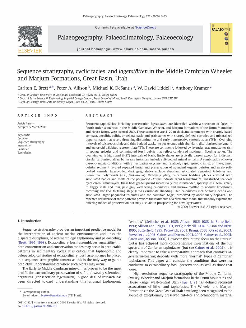
High-resolution sequence stratigraphy of the Middle CambrianSwasey, Wheeler and Marjum formations in the DrumMountains andHouse Range, west-central Utah (Figs. 1, 2) has defined recurrentassociations of litho- and taphofacies. The Wheeler and Marjumformations in the Great Basin of Utah have long been recognized as thesource of exceptionally preserved trilobite and echinoderm material
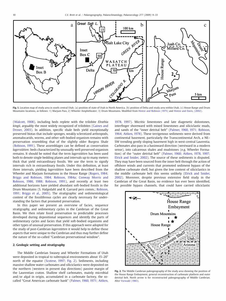
Fig. 1. Location map of study area in south-central Utah. (a) position of state of Utah in North America. (b) position of Delta and study area within Utah. (c) House Range and DrumMountains locations, as follows: 1) Marjum Pass, 2) Wheeler Amphitheater; 3) Drum Mountains. Modified from Hintze and Robison (1975) and Hintze and Davis, (2002).
Fig. 2. The Middle Cambrian paleogeography of the study area showing the position ofthe House Range Embayment, general reconstruction of carbonate platform and outerdetrital belt. North arrow is for reconstructed paleogeography of Middle Cambrian.After Vorwald (1983).
10 C.E. Brett et al. / Palaeogeography, Palaeoclimatology, Palaeoecology 277 (2009) 9–33
(Walcott, 1908), including beds replete with the trilobite Elrathiakingii, arguably the most widely recognized of trilobites (Gaines andDroser, 2003). In addition, specific shale beds yield exceptionallypreserved biotas that include sponges, weakly sclerotized arthropods,anomalocarids, worms, and other soft-bodied organism remains withpreservation resembling that of the slightly older Burgess Shale(Robison, 1991). These assemblages can be defined as conservationlagerstätten: beds characterized by unusually well preserved organismremains. It should be noted that the term lagerstätten has been usedboth to denote single bedding planes and intervals up to many metersthick that yield extraordinary fossils. We use the term to signifyintervals rich in extraordinary fossils. Under this definition, at leastthree intervals, yielding lagerstätten have been described from theWheeler and Marjum formations in the House Range (Rogers, 1984;Briggs and Robison, 1984; Robison, 1984a; Conway Morris andRobison, 1986, 1988; Robison, 1991), and recently at least twoadditional horizons have yielded abundant soft-bodied fossils in theDrum Mountains (S. Halgedahl and R. Garrard pers comm.; Robison,1991; Briggs et al., 2005). The stratigraphic and sedimentologicalcontext of the fossiliferous cycles are clearly necessary for under-standing the factors that promoted preservation.
In this paper we present an overview of facies, sequencestratigraphy, and sedimentary cycles in the Cambrian of the GreatBasin. We then relate fossil preservation to predictable processesdeveloped during depositional sequences and identify the parts ofsedimentary cycles and facies that yield soft-bodied organisms andother types of unusual preservation. If this approach were adopted forthe study of post-Cambrian lagerstätten it would help to define thoseaspects that were unique to the Cambrian and thus may further definethe nature of the so-called “Cambrian preservational window”.
2. Geologic setting and stratigraphy
The Middle Cambrian Swasey and Wheeler Formations of Utahwere deposited in tropical to subtropical environments about 15–20°north of the equator (Scotese, 1997; Fig. 2). Sediments, includingmassive shallow water carbonates and siliciclastics were deposited onthe northern (western in present day directions) passive margin ofthe Laurentian craton. Shallow shelf carbonates, mainly microbialand/or algal in origin, accumulated in a carbonate factory, the so-called “Great American carbonate bank” (Palmer, 1960, 1971; Aitken,
1978, 1997). Micritic limestones and late diagenetic dolostones,interfinger shoreward with mixed limestones and siliciclastic muds,and sands of the “inner detrital belt” (Palmer, 1960, 1971; Robison,1964; Aitken, 1978). These terrigenous sediments were derived fromcontinental basement, particularly the Transcontinental Arch, a NE–SW trending gently sloping basement high in west-central Laurentia.Carbonates also pass in a basinward direction (westward in a modernsense), into calcareous shales and mudstones (e.g. Wheeler Forma-tion) of the “outer detrital belt” (Palmer, 1960; Aitken, 1978, 1997;Elrick and Snider, 2002). The source of these sediments is disputed.Theymay have been sourced from the inner belt through the action ofoffshore winds and currents that promoted sediment bypass of theshallow carbonate shelf, but given the low content of siliciclastics inthe middle carbonate belt this seems unlikely (Elrick and Snider,2002). Moreover, despite previous extensive field study in theCambrian of the Great Basin, no evidence has ever been identified,for possible bypass channels, that could have carried siliciclastic
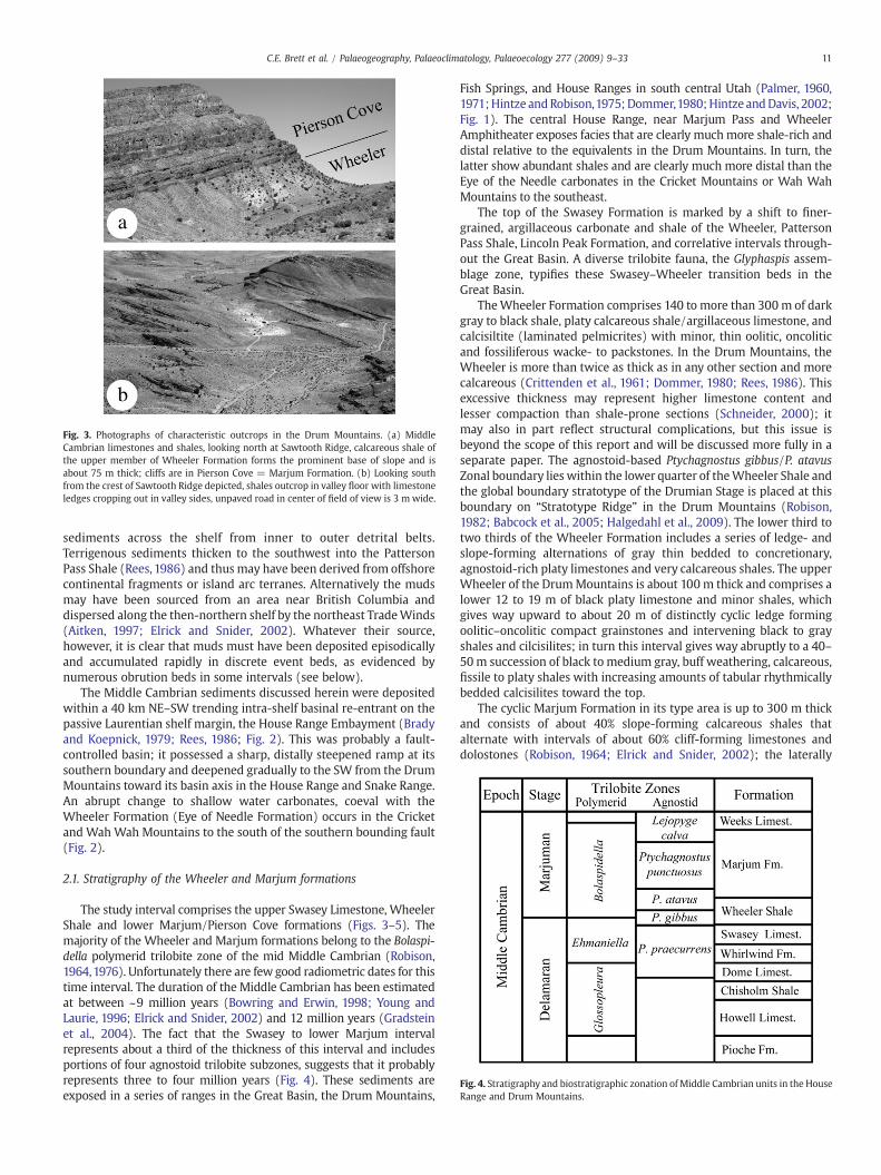
Fig. 3. Photographs of characteristic outcrops in the Drum Mountains. (a) MiddleCambrian limestones and shales, looking north at Sawtooth Ridge, calcareous shale ofthe upper member of Wheeler Formation forms the prominent base of slope and isabout 75 m thick; cliffs are in Pierson Cove = Marjum Formation. (b) Looking southfrom the crest of Sawtooth Ridge depicted, shales outcrop in valley floor with limestoneledges cropping out in valley sides, unpaved road in center of field of view is 3 m wide.
Fig. 4. Stratigraphy and biostratigraphic zonation ofMiddle Cambrian units in the HouseRange and Drum Mountains.
11C.E. Brett et al. / Palaeogeography, Palaeoclimatology, Palaeoecology 277 (2009) 9–33
sediments across the shelf from inner to outer detrital belts.Terrigenous sediments thicken to the southwest into the PattersonPass Shale (Rees, 1986) and thus may have been derived from offshorecontinental fragments or island arc terranes. Alternatively the mudsmay have been sourced from an area near British Columbia anddispersed along the then-northern shelf by the northeast TradeWinds(Aitken, 1997; Elrick and Snider, 2002). Whatever their source,however, it is clear that muds must have been deposited episodicallyand accumulated rapidly in discrete event beds, as evidenced bynumerous obrution beds in some intervals (see below).
The Middle Cambrian sediments discussed herein were depositedwithin a 40 km NE–SW trending intra-shelf basinal re-entrant on thepassive Laurentian shelf margin, the House Range Embayment (Bradyand Koepnick, 1979; Rees, 1986; Fig. 2). This was probably a fault-controlled basin; it possessed a sharp, distally steepened ramp at itssouthern boundary and deepened gradually to the SW from the DrumMountains toward its basin axis in the House Range and Snake Range.An abrupt change to shallow water carbonates, coeval with theWheeler Formation (Eye of Needle Formation) occurs in the Cricketand Wah Wah Mountains to the south of the southern bounding fault(Fig. 2).
2.1. Stratigraphy of the Wheeler and Marjum formations
The study interval comprises the upper Swasey Limestone, WheelerShale and lower Marjum/Pierson Cove formations (Figs. 3–5). Themajority of the Wheeler and Marjum formations belong to the Bolaspi-della polymerid trilobite zone of the mid Middle Cambrian (Robison,1964,1976). Unfortunately there are few good radiometric dates for thistime interval. The duration of the Middle Cambrian has been estimatedat between ~9 million years (Bowring and Erwin, 1998; Young andLaurie, 1996; Elrick and Snider, 2002) and 12 million years (Gradsteinet al., 2004). The fact that the Swasey to lower Marjum intervalrepresents about a third of the thickness of this interval and includesportions of four agnostoid trilobite subzones, suggests that it probablyrepresents three to four million years (Fig. 4). These sediments areexposed in a series of ranges in the Great Basin, the Drum Mountains,
Fish Springs, and House Ranges in south central Utah (Palmer, 1960,1971;Hintze andRobison,1975; Dommer,1980;Hintze andDavis, 2002;Fig. 1). The central House Range, near Marjum Pass and WheelerAmphitheater exposes facies that are clearly muchmore shale-rich anddistal relative to the equivalents in the Drum Mountains. In turn, thelatter show abundant shales and are clearly much more distal than theEye of the Needle carbonates in the Cricket Mountains or Wah WahMountains to the southeast.
The top of the Swasey Formation is marked by a shift to finer-grained, argillaceous carbonate and shale of the Wheeler, PattersonPass Shale, Lincoln Peak Formation, and correlative intervals through-out the Great Basin. A diverse trilobite fauna, the Glyphaspis assem-blage zone, typifies these Swasey–Wheeler transition beds in theGreat Basin.
TheWheeler Formation comprises 140 to more than 300 m of darkgray to black shale, platy calcareous shale/argillaceous limestone, andcalcisiltite (laminated pelmicrites) with minor, thin oolitic, oncoliticand fossiliferous wacke- to packstones. In the Drum Mountains, theWheeler is more than twice as thick as in any other section and morecalcareous (Crittenden et al., 1961; Dommer, 1980; Rees, 1986). Thisexcessive thickness may represent higher limestone content andlesser compaction than shale-prone sections (Schneider, 2000); itmay also in part reflect structural complications, but this issue isbeyond the scope of this report and will be discussed more fully in aseparate paper. The agnostoid-based Ptychagnostus gibbus/P. atavusZonal boundary lies within the lower quarter of theWheeler Shale andthe global boundary stratotype of the Drumian Stage is placed at thisboundary on “Stratotype Ridge” in the Drum Mountains (Robison,1982; Babcock et al., 2005; Halgedahl et al., 2009). The lower third totwo thirds of the Wheeler Formation includes a series of ledge- andslope-forming alternations of gray thin bedded to concretionary,agnostoid-rich platy limestones and very calcareous shales. The upperWheeler of the DrumMountains is about 100 m thick and comprises alower 12 to 19 m of black platy limestone and minor shales, whichgives way upward to about 20 m of distinctly cyclic ledge formingoolitic–oncolitic compact grainstones and intervening black to grayshales and cilcisilites; in turn this interval gives way abruptly to a 40–50m succession of black to medium gray, buff weathering, calcareous,fissile to platy shales with increasing amounts of tabular rhythmicallybedded calcisilites toward the top.
The cyclic Marjum Formation in its type area is up to 300 m thickand consists of about 40% slope-forming calcareous shales thatalternate with intervals of about 60% cliff-forming limestones anddolostones (Robison, 1964; Elrick and Snider, 2002); the laterally
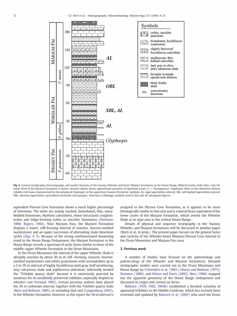
Fig. 5. General stratigraphy, biostratigraphy, and marker horizons of the Swasey, Wheeler and lower Marjum formations in the House Range, Millard County, Utah. Note: only thelower third of the Marjum Formation is shown. Second column shows approximate positions of agnostoid zones; P. = Ptychagnostus; Glyphaspis refers to the distinctive diversetrilobite-rich fauna characterized by the polymerid Glyphaspis, in the uppermost Swasey Formation. Symbols: AL: algal lagerstätten interval; SBL: soft-bodied lagerstätten interval;OBL: obrution lagerstätten (articulated eocrinoids and sponges). Note key to lithologic symbols used in this and all subsequent figures.
12 C.E. Brett et al. / Palaeogeography, Palaeoclimatology, Palaeoecology 277 (2009) 9–33
equivalent Pierson Cove Formation shows a much higher percentageof limestone. The latter are mainly stacked, bioturbated, thin, wavy-bedded limestones, rhythmic calcisiltites, minor intraclastic conglom-erates and ledge-forming oolitic to oncolitic limestones (Dommer,1980; Rogers, 1984). Near Marjum Pass, the Marjum Formationdisplays a lower, cliff-forming interval of massive, burrow-mottledwackestones and an upper succession of alternating shale-limestonecycles (Figs. 4, 5). Because of the strong southwestward deepeningtrend in the House Range Embayment, the Marjum Formation in theHouse Range records a spectrum of cyclic facies similar to those of themiddle–upper Wheeler Formation in the Drum Mountains.
In the Drum Mountains the interval of the upper Wheeler Shale isabruptly overlain by about 30 m of cliff -forming, massive, burrow-mottled wackestones and oolitic grainstones with stromatolites up toa 5 to 30 m interval of highly fossiliferous dark gray, buff weathering,very calcareous shale and argillaceous dolostone, informally termedthe “Trilobite quarry shale” because it is extensively quarried byamateurs for its excellently preserved trilobites, especially Asaphiscuswheeleri (see Vorwald, 1983). Certain previous authors have placedthe 30 m carbonate interval, together with the Trilobite quarry shale(Rees and Robison, 1989), or excluding that unit (Langenburg, 2003),in theWheeler Formation. However, in this report the 30 m interval is
assigned to the Pierson Cove Formation, as it appears to be morelithologically similar to that unit and is a lateral facies equivalent of thelower cycles of the Marjum Formation, which overlie the WheelerShale at its type area in the central House Range.
Details of physical and sequence stratigraphy in the Swasey,Wheeler, and Marjum formations will be discussed in another paper(Brett et al., in prep.). The present paper focuses on the general faciesand cyclicity of the Wheeler-lower Marjum/Pierson Cove interval inthe Drum Mountains and Marjum Pass area.
3. Previous work
A number of studies have focused on the paleontology andpaleoecology of the Wheeler and Marjum formations. Detailedstratigraphic studies were carried out in the Drum Mountains andHouse Range by Crittenden et al. (1961), Hintze and Robison (1975),Dommer (1980), and Hintze and Davis (2002). Rees (1986) mappedout the apparent geometry of the House Range embayment anddiscussed its origin and control on facies.
Robison (1976, 1982, 1984b) established a detailed zonation ofagnostoid trilobites in the Middle Cambrian, which has recently beenreviewed and updated by Babcock et al. (2005) who used the Drum
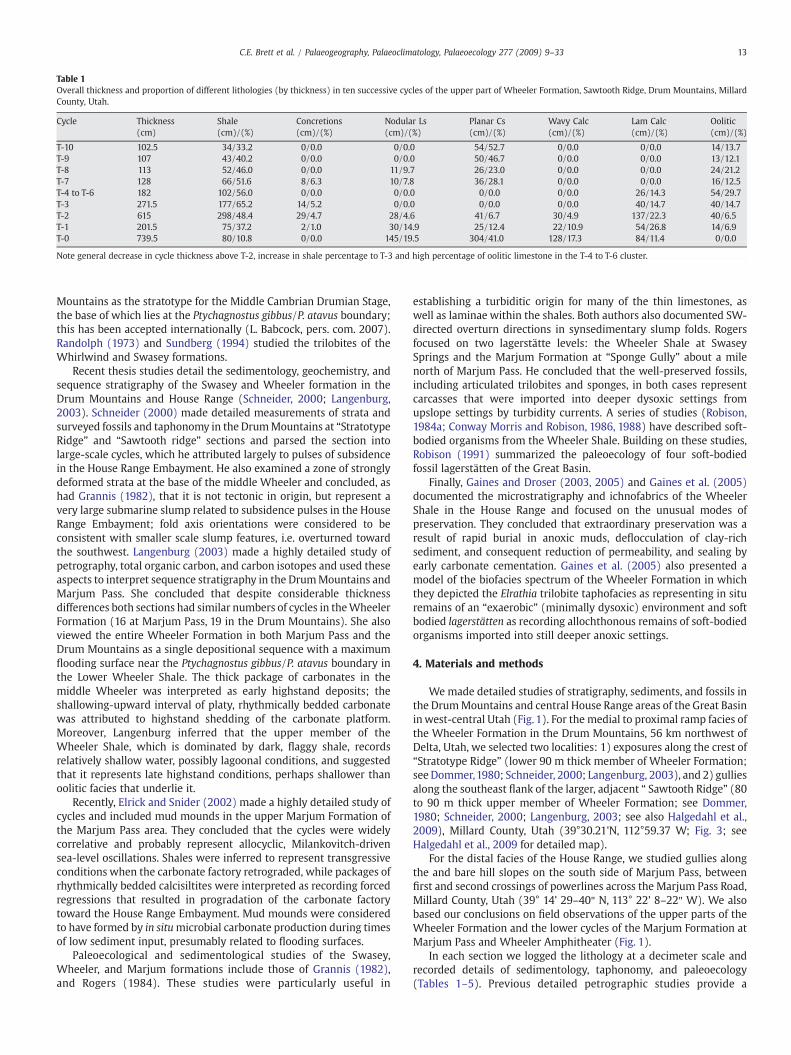
Table 1Overall thickness and proportion of different lithologies (by thickness) in ten successive cycles of the upper part of Wheeler Formation, Sawtooth Ridge, Drum Mountains, MillardCounty, Utah.
Cycle Thickness Shale Concretions Nodular Ls Planar Cs Wavy Calc Lam Calc Oolitic(cm) (cm)/(%) (cm)/(%) (cm)/(%) (cm)/(%) (cm)/(%) (cm)/(%) (cm)/(%)
T-10 102.5 34/33.2 0/0.0 0/0.0 54/52.7 0/0.0 0/0.0 14/13.7T-9 107 43/40.2 0/0.0 0/0.0 50/46.7 0/0.0 0/0.0 13/12.1T-8 113 52/46.0 0/0.0 11/9.7 26/23.0 0/0.0 0/0.0 24/21.2T-7 128 66/51.6 8/6.3 10/7.8 36/28.1 0/0.0 0/0.0 16/12.5T-4 to T-6 182 102/56.0 0/0.0 0/0.0 0/0.0 0/0.0 26/14.3 54/29.7T-3 271.5 177/65.2 14/5.2 0/0.0 0/0.0 0/0.0 40/14.7 40/14.7T-2 615 298/48.4 29/4.7 28/4.6 41/6.7 30/4.9 137/22.3 40/6.5T-1 201.5 75/37.2 2/1.0 30/14.9 25/12.4 22/10.9 54/26.8 14/6.9T-0 739.5 80/10.8 0/0.0 145/19.5 304/41.0 128/17.3 84/11.4 0/0.0
Note general decrease in cycle thickness above T-2, increase in shale percentage to T-3 and high percentage of oolitic limestone in the T-4 to T-6 cluster.
13C.E. Brett et al. / Palaeogeography, Palaeoclimatology, Palaeoecology 277 (2009) 9–33
Mountains as the stratotype for the Middle Cambrian Drumian Stage,the base of which lies at the Ptychagnostus gibbus/P. atavus boundary;this has been accepted internationally (L. Babcock, pers. com. 2007).Randolph (1973) and Sundberg (1994) studied the trilobites of theWhirlwind and Swasey formations.
Recent thesis studies detail the sedimentology, geochemistry, andsequence stratigraphy of the Swasey and Wheeler formation in theDrum Mountains and House Range (Schneider, 2000; Langenburg,2003). Schneider (2000) made detailed measurements of strata andsurveyed fossils and taphonomy in the DrumMountains at “StratotypeRidge” and “Sawtooth ridge” sections and parsed the section intolarge-scale cycles, which he attributed largely to pulses of subsidencein the House Range Embayment. He also examined a zone of stronglydeformed strata at the base of the middle Wheeler and concluded, ashad Grannis (1982), that it is not tectonic in origin, but represent avery large submarine slump related to subsidence pulses in the HouseRange Embayment; fold axis orientations were considered to beconsistent with smaller scale slump features, i.e. overturned towardthe southwest. Langenburg (2003) made a highly detailed study ofpetrography, total organic carbon, and carbon isotopes and used theseaspects to interpret sequence stratigraphy in the DrumMountains andMarjum Pass. She concluded that despite considerable thicknessdifferences both sections had similar numbers of cycles in theWheelerFormation (16 at Marjum Pass, 19 in the Drum Mountains). She alsoviewed the entire Wheeler Formation in both Marjum Pass and theDrum Mountains as a single depositional sequence with a maximumflooding surface near the Ptychagnostus gibbus/P. atavus boundary inthe Lower Wheeler Shale. The thick package of carbonates in themiddle Wheeler was interpreted as early highstand deposits; theshallowing-upward interval of platy, rhythmically bedded carbonatewas attributed to highstand shedding of the carbonate platform.Moreover, Langenburg inferred that the upper member of theWheeler Shale, which is dominated by dark, flaggy shale, recordsrelatively shallow water, possibly lagoonal conditions, and suggestedthat it represents late highstand conditions, perhaps shallower thanoolitic facies that underlie it.
Recently, Elrick and Snider (2002) made a highly detailed study ofcycles and included mud mounds in the upper Marjum Formation ofthe Marjum Pass area. They concluded that the cycles were widelycorrelative and probably represent allocyclic, Milankovitch-drivensea-level oscillations. Shales were inferred to represent transgressiveconditions when the carbonate factory retrograded, while packages ofrhythmically bedded calcisiltites were interpreted as recording forcedregressions that resulted in progradation of the carbonate factorytoward the House Range Embayment. Mud mounds were consideredto have formed by in situmicrobial carbonate production during timesof low sediment input, presumably related to flooding surfaces.
Paleoecological and sedimentological studies of the Swasey,Wheeler, and Marjum formations include those of Grannis (1982),and Rogers (1984). These studies were particularly useful in
establishing a turbiditic origin for many of the thin limestones, aswell as laminae within the shales. Both authors also documented SW-directed overturn directions in synsedimentary slump folds. Rogersfocused on two lagerstätte levels: the Wheeler Shale at SwaseySprings and the Marjum Formation at “Sponge Gully” about a milenorth of Marjum Pass. He concluded that the well-preserved fossils,including articulated trilobites and sponges, in both cases representcarcasses that were imported into deeper dysoxic settings fromupslope settings by turbidity currents. A series of studies (Robison,1984a; Conway Morris and Robison, 1986, 1988) have described soft-bodied organisms from the Wheeler Shale. Building on these studies,Robison (1991) summarized the paleoecology of four soft-bodiedfossil lagerstätten of the Great Basin.
Finally, Gaines and Droser (2003, 2005) and Gaines et al. (2005)documented the microstratigraphy and ichnofabrics of the WheelerShale in the House Range and focused on the unusual modes ofpreservation. They concluded that extraordinary preservation was aresult of rapid burial in anoxic muds, deflocculation of clay-richsediment, and consequent reduction of permeability, and sealing byearly carbonate cementation. Gaines et al. (2005) also presented amodel of the biofacies spectrum of the Wheeler Formation in whichthey depicted the Elrathia trilobite taphofacies as representing in situremains of an “exaerobic” (minimally dysoxic) environment and softbodied lagerstätten as recording allochthonous remains of soft-bodiedorganisms imported into still deeper anoxic settings.
4. Materials and methods
Wemade detailed studies of stratigraphy, sediments, and fossils inthe DrumMountains and central House Range areas of the Great Basininwest-central Utah (Fig. 1). For the medial to proximal ramp facies ofthe Wheeler Formation in the Drum Mountains, 56 km northwest ofDelta, Utah, we selected two localities: 1) exposures along the crest of“Stratotype Ridge” (lower 90 m thick member of Wheeler Formation;see Dommer,1980; Schneider, 2000; Langenburg, 2003), and 2) gulliesalong the southeast flank of the larger, adjacent “ Sawtooth Ridge” (80to 90 m thick upper member of Wheeler Formation; see Dommer,1980; Schneider, 2000; Langenburg, 2003; see also Halgedahl et al.,2009), Millard County, Utah (39°30.21'N, 112°59.37 W; Fig. 3; seeHalgedahl et al., 2009 for detailed map).
For the distal facies of the House Range, we studied gullies alongthe and bare hill slopes on the south side of Marjum Pass, betweenfirst and second crossings of powerlines across the Marjum Pass Road,Millard County, Utah (39° 14' 29–40q N, 113° 22' 8–22q W). We alsobased our conclusions on field observations of the upper parts of theWheeler Formation and the lower cycles of the Marjum Formation atMarjum Pass and Wheeler Amphitheater (Fig. 1).
In each section we logged the lithology at a decimeter scale andrecorded details of sedimentology, taphonomy, and paleoecology(Tables 1–5). Previous detailed petrographic studies provide a
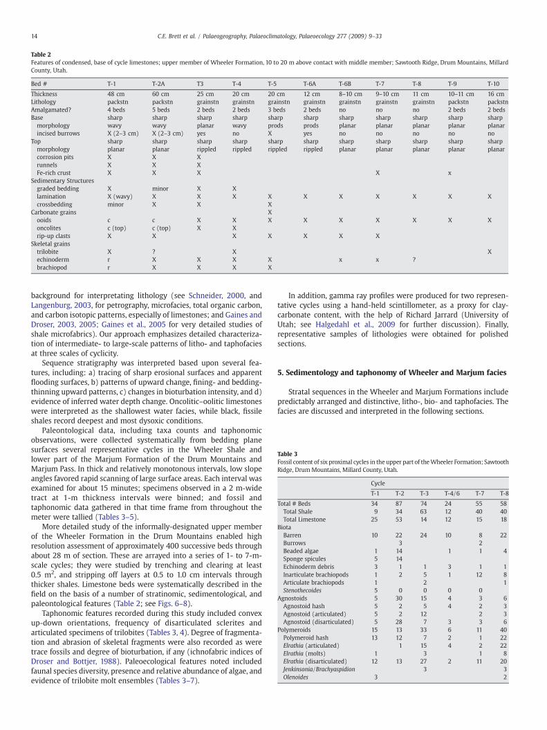
Table 2Features of condensed, base of cycle limestones; upper member of Wheeler Formation, 10 to 20 m above contact with middle member; Sawtooth Ridge, Drum Mountains, MillardCounty, Utah.
Bed # T-1 T-2A T3 T-4 T-5 T-6A T-6B T-7 T-8 T-9 T-10
Thickness 48 cm 60 cm 25 cm 20 cm 20 cm 12 cm 8–10 cm 9–10 cm 11 cm 10–11 cm 16 cmLithology packstn packstn grainstn grainstn grainstn grainstn grainstn grainstn grainstn packstn packstnAmalgamated? 4 beds 5 beds 2 beds 2 beds 3 beds 2 beds no no no 2 beds 2 bedsBase sharp sharp sharp sharp sharp sharp sharp sharp sharp sharp sharpmorphology wavy wavy planar wavy prods prods planar planar planar planar planarincised burrows X (2–3 cm) X (2–3 cm) yes no X yes no no no no no
Top sharp sharp sharp sharp sharp sharp sharp sharp sharp sharp sharpmorphology planar planar rippled rippled rippled rippled planar planar planar planar planarcorrosion pits X X Xrunnels X X XFe-rich crust X X X X x
Sedimentary Structuresgraded bedding X minor X Xlamination X (wavy) X X X X X X X X X Xcrossbedding minor X X X
Carbonate grains Xooids c c X X X X X X X X Xoncolites c (top) c (top) X Xrip-up clasts X X X X X X X
Skeletal grainstrilobite X ? X Xechinoderm r X X X X x x ?brachiopod r X X X X
Table 3Fossil content of six proximal cycles in the upper part of theWheeler Formation; SawtoothRidge, DrumMountains, Millard County, Utah.
Cycle
T-1 T-2 T-3 T-4/6 T-7 T-8
Total # Beds 34 87 74 24 55 58Total Shale 9 34 63 12 40 40Total Limestone 25 53 14 12 15 18
BiotaBarren 10 22 24 10 8 22Burrows 3 2Beaded algae 1 14 1 1 4Sponge spicules 5 14Echinoderm debris 3 1 1 3 1 1Inarticulate brachiopods 1 2 5 1 12 8Articulate brachiopods 1 2 1Stenothecoides 5 0 0 0 0
Agnostoids 5 30 15 4 3 6Agnostoid hash 5 2 5 4 2 3Agnostoid (articulated) 5 2 12 2 3Agnostoid (disarticulated) 5 28 7 3 3 6
Polymeroids 15 13 33 6 11 40Polymeroid hash 13 12 7 2 1 22Elrathia (articulated) 1 15 4 2 22Elrathia (molts) 1 3 1 8Elrathia (disarticulated) 12 13 27 2 11 20Jenkinsonia/Brachyaspidion 3 3Olenoides 3 2
14 C.E. Brett et al. / Palaeogeography, Palaeoclimatology, Palaeoecology 277 (2009) 9–33
background for interpretating lithology (see Schneider, 2000, andLangenburg, 2003, for petrography, microfacies, total organic carbon,and carbon isotopic patterns, especially of limestones; and Gaines andDroser, 2003, 2005; Gaines et al., 2005 for very detailed studies ofshale microfabrics). Our approach emphasizes detailed characteriza-tion of intermediate- to large-scale patterns of litho- and taphofaciesat three scales of cyclicity.
Sequence stratigraphy was interpreted based upon several fea-tures, including: a) tracing of sharp erosional surfaces and apparentflooding surfaces, b) patterns of upward change, fining- and bedding-thinning upward patterns, c) changes in bioturbation intensity, and d)evidence of inferred water depth change. Oncolitic–oolitic limestoneswere interpreted as the shallowest water facies, while black, fissileshales record deepest and most dysoxic conditions.
Paleontological data, including taxa counts and taphonomicobservations, were collected systematically from bedding planesurfaces several representative cycles in the Wheeler Shale andlower part of the Marjum Formation of the Drum Mountains andMarjum Pass. In thick and relatively monotonous intervals, low slopeangles favored rapid scanning of large surface areas. Each interval wasexamined for about 15 minutes; specimens observed in a 2 m-widetract at 1-m thickness intervals were binned; and fossil andtaphonomic data gathered in that time frame from throughout themeter were tallied (Tables 3–5).
More detailed study of the informally-designated upper memberof the Wheeler Formation in the Drum Mountains enabled highresolution assessment of approximately 400 successive beds throughabout 28 m of section. These are arrayed into a series of 1- to 7-m-scale cycles; they were studied by trenching and clearing at least0.5 m2, and stripping off layers at 0.5 to 1.0 cm intervals throughthicker shales. Limestone beds were systematically described in thefield on the basis of a number of stratinomic, sedimentological, andpaleontological features (Table 2; see Figs. 6–8).
Taphonomic features recorded during this study included convexup-down orientations, frequency of disarticulated sclerites andarticulated specimens of trilobites (Tables 3, 4). Degree of fragmenta-tion and abrasion of skeletal fragments were also recorded as weretrace fossils and degree of bioturbation, if any (ichnofabric indices ofDroser and Bottjer, 1988). Paleoecological features noted includedfaunal species diversity, presence and relative abundance of algae, andevidence of trilobite molt ensembles (Tables 3–7).
In addition, gamma ray profiles were produced for two represen-tative cycles using a hand-held scintillometer, as a proxy for clay-carbonate content, with the help of Richard Jarrard (University ofUtah; see Halgedahl et al., 2009 for further discussion). Finally,representative samples of lithologies were obtained for polishedsections.
5. Sedimentology and taphonomy of Wheeler and Marjum facies
Stratal sequences in the Wheeler and Marjum Formations includepredictably arranged and distinctive, litho-, bio- and taphofacies. Thefacies are discussed and interpreted in the following sections.
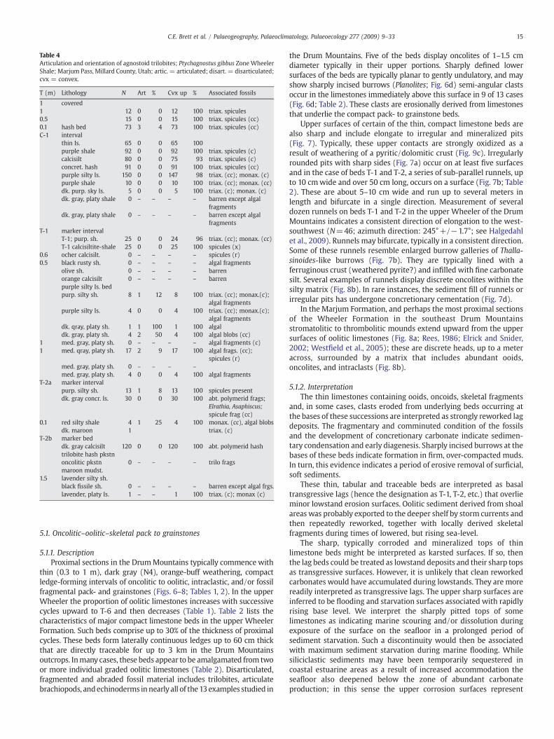
Table 4Articulation and orientation of agnostoid trilobites; Ptychagnostus gibbus Zone WheelerShale; Marjum Pass, Millard County, Utah; artic. = articulated; disart. = disarticulated;cvx = convex.
T (m) Lithology N Art % Cvx up % Associated fossils
1 covered1 12 0 0 12 100 triax. spicules0.5 15 0 0 15 100 triax. spicules (cc)0.1 hash bed 73 3 4 73 100 triax. spicules (cc)C-1 interval
thin Is. 65 0 0 65 100purple shale 92 0 0 92 100 triax. spicules (c)calcisilt 80 0 0 75 93 triax. spicules (c)concret. hash 91 0 0 91 100 triax. spicules (cc)purple silty Is. 150 0 0 147 98 triax. (cc); monax. (c)purple shale 10 0 0 10 100 triax. (cc); monax. (cc)dk. purp. sky Is. 5 0 0 5 100 triax. (c); monax. (c)dk. gray, platy shale 0 – – – – barren except algal
fragmentsdk. gray, platy shale 0 – – – – barren except algal
fragmentsT-1 marker interval
T-1; purp. sh. 25 0 0 24 96 triax. (cc); monax. (cc)T-1 calcisiltite-shale 25 0 0 25 100 spicules (x)
0.6 ocher calcisilt. 0 – – – – spicules (r)0.5 black rusty sh. 0 – – – – algal fragments
olive sh. 0 – – – – barrenorange calcisilt 0 – – – – barrenpurple silty Is. bedpurp. silty sh. 8 1 12 8 100 triax. (cc); monax.(c);
algal fragmentspurple silty Is. 4 0 0 4 100 triax. (cc); monax.(c);
algal fragmentsdk. qray, platy sh. 1 1 100 1 100 algaldk. gray, platy sh. 4 2 50 4 100 algal blobs (cc)
1 med. gray, platy sh. 0 – – – – algal fragments (c)1 med. qray, platy sh. 17 2 9 17 100 algal frags. (cc);
spicules (r)med. gray, platy sh. 0 – – – –
med. gray, platy sh. 4 0 0 4 100 algal fragmentsT-2a marker interval
purp. silty sh. 13 1 8 13 100 spicules presentdk. gray concr. Is. 30 0 0 30 100 abt. polymerid frags;
Elrathia, Asaphiscus;spicule frag (cc)
0.1 red silty shale 4 1 25 4 100 monax. (cc), algal blobsdk. maroon 1 triax. (c)
T-2b marker beddk. gray calcisilt 120 0 0 120 100 abt. polymerid hashtrilobite hash pkstnoncolitic pkstn 0 – – – – trilo fragsmaroon mudst.
1.5 lavender silty sh.black fissile sh. 0 – – – – barren except algal frgs.lavender, platy Is. 1 – – 1 100 triax. (c); monax (c)
15C.E. Brett et al. / Palaeogeography, Palaeoclimatology, Palaeoecology 277 (2009) 9–33
5.1. Oncolitic–oolitic–skeletal pack to grainstones
5.1.1. DescriptionProximal sections in the DrumMountains typically commence with
thin (0.3 to 1 m), dark gray (N4), orange-buff weathering, compactledge-forming intervals of oncolitic to oolitic, intraclastic, and/or fossilfragmental pack- and grainstones (Figs. 6–8; Tables 1, 2). In the upperWheeler the proportion of oolitic limestones increases with successivecycles upward to T-6 and then decreases (Table 1). Table 2 lists thecharacteristics of major compact limestone beds in the upper WheelerFormation. Such beds comprise up to 30% of the thickness of proximalcycles. These beds form laterally continuous ledges up to 60 cm thickthat are directly traceable for up to 3 km in the Drum Mountainsoutcrops. Inmany cases, these beds appear to be amalgamated from twoor more individual graded oolitic limestones (Table 2). Disarticulated,fragmented and abraded fossil material includes trilobites, articulatebrachiopods, andechinoderms innearlyall of the13examples studied in
the Drum Mountains. Five of the beds display oncolites of 1–1.5 cmdiameter typically in their upper portions. Sharply defined lowersurfaces of the beds are typically planar to gently undulatory, and mayshow sharply incised burrows (Planolites; Fig. 6d) semi-angular clastsoccur in the limestones immediately above this surface in 9 of 13 cases(Fig. 6d; Table 2). These clasts are erosionally derived from limestonesthat underlie the compact pack- to grainstone beds.
Upper surfaces of certain of the thin, compact limestone beds arealso sharp and include elongate to irregular and mineralized pits(Fig. 7). Typically, these upper contacts are strongly oxidized as aresult of weathering of a pyritic/dolomitic crust (Fig. 9c). Irregularlyrounded pits with sharp sides (Fig. 7a) occur on at least five surfacesand in the case of beds T-1 and T-2, a series of sub-parallel runnels, upto 10 cmwide and over 50 cm long, occurs on a surface (Fig. 7b; Table2). These are about 5–10 cm wide and run up to several meters inlength and bifurcate in a single direction. Measurement of severaldozen runnels on beds T-1 and T-2 in the upper Wheeler of the DrumMountains indicates a consistent direction of elongation to the west-southwest (N=46; azimuth direction: 245°+/−1.7°; see Halgedahlet al., 2009). Runnels may bifurcate, typically in a consistent direction.Some of these runnels resemble enlarged burrow galleries of Thalla-sinoides-like burrows (Fig. 7b). They are typically lined with aferruginous crust (weathered pyrite?) and infilled with fine carbonatesilt. Several examples of runnels display discrete oncolites within thesilty matrix (Fig. 8b). In rare instances, the sediment fill of runnels orirregular pits has undergone concretionary cementation (Fig. 7d).
In the Marjum Formation, and perhaps the most proximal sectionsof the Wheeler Formation in the southeast Drum Mountainsstromatolitic to thrombolitic mounds extend upward from the uppersurfaces of oolitic limestones (Fig. 8a; Rees, 1986; Elrick and Snider,2002; Westfield et al., 2005); these are discrete heads, up to a meteracross, surrounded by a matrix that includes abundant ooids,oncolites, and intraclasts (Fig. 8b).
5.1.2. InterpretationThe thin limestones containing ooids, oncoids, skeletal fragments
and, in some cases, clasts eroded from underlying beds occurring atthe bases of these successions are interpreted as strongly reworked lagdeposits. The fragmentary and comminuted condition of the fossilsand the development of concretionary carbonate indicate sedimen-tary condensation and early diagenesis. Sharply incised burrows at thebases of these beds indicate formation in firm, over-compacted muds.In turn, this evidence indicates a period of erosive removal of surficial,soft sediments.
These thin, tabular and traceable beds are interpreted as basaltransgressive lags (hence the designation as T-1, T-2, etc.) that overlieminor lowstand erosion surfaces. Oolitic sediment derived from shoalareas was probably exported to the deeper shelf by storm currents andthen repeatedly reworked, together with locally derived skeletalfragments during times of lowered, but rising sea-level.
The sharp, typically corroded and mineralized tops of thinlimestone beds might be interpreted as karsted surfaces. If so, thenthe lag beds could be treated as lowstand deposits and their sharp topsas transgressive surfaces. However, it is unlikely that clean reworkedcarbonates would have accumulated during lowstands. They are morereadily interpreted as transgressive lags. The upper sharp surfaces areinferred to be flooding and starvation surfaces associated with rapidlyrising base level. We interpret the sharply pitted tops of somelimestones as indicating marine scouring and/or dissolution duringexposure of the surface on the seafloor in a prolonged period ofsediment starvation. Such a discontinuity would then be associatedwith maximum sediment starvation during marine flooding. Whilesiliciclastic sediments may have been temporarily sequestered incoastal estuarine areas as a result of increased accommodation theseafloor also deepened below the zone of abundant carbonateproduction; in this sense the upper corrosion surfaces represent
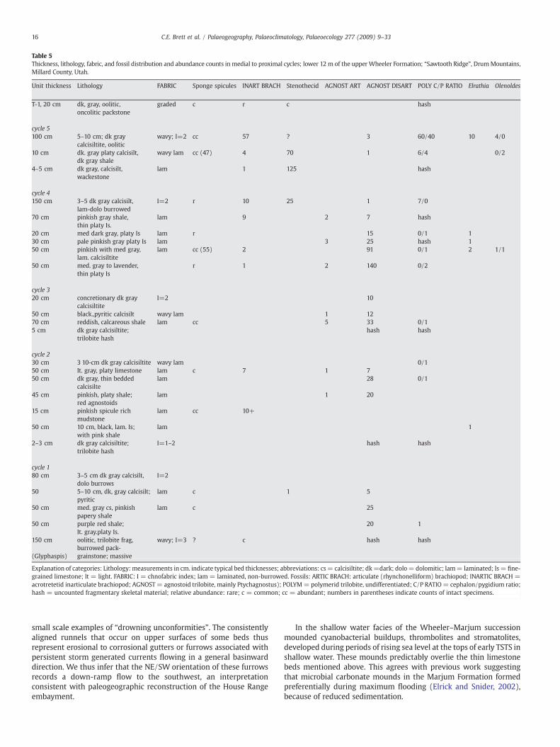
Table 5Thickness, lithology, fabric, and fossil distribution and abundance counts in medial to proximal cycles; lower 12 m of the upper Wheeler Formation; “Sawtooth Ridge”, DrumMountains,Millard County, Utah.
Unit thickness Lithology FABRIC Sponge spicules INART BRACH Stenothecid AGNOST ART AGNOST DISART POLY C/P RATIO Elrathia Olenoldes
T-1, 20 cm dk, gray, oolitic,oncolitic packstone
graded c r c hash
cycle 5100 cm 5–10 cm; dk gray
calcisiltite, ooliticwavy; I=2 cc 57 ? 3 60/40 10 4/0
10 cm dk. gray platy calcisilt,dk gray shale
wavy lam cc (47) 4 70 1 6/4 0/2
4–5 cm dk gray, calcisilt,wackestone
lam 1 125 hash
cycle 4150 cm 3–5 dk gray calcisilt,
lam-dolo burrowedI=2 r 10 25 1 7/0
70 cm pinkish gray shale,thin platy Is.
lam 9 2 7 hash
20 cm med dark gray, platy Is lam r 15 0/1 130 cm pale pinkish gray platy Is lam 3 25 hash 150 cm pinkish with med gray,
lam. calcisiltitelam cc (55) 2 91 0/1 2 1/1
50 cm med. gray to lavender,thin platy Is
r 1 2 140 0/2
cycle 320 cm concretionary dk gray
calcisiltiteI=2 10
50 cm black.,pyritic calcisilt wavy lam 1 1270 cm reddish, calcareous shale lam cc 5 33 0/15 cm dk gray calcisiltite;
trilobite hashhash hash
cycle 230 cm 3 10-cm dk gray calcisiltite wavy lam 0/150 cm It. gray, platy limestone lam c 7 1 750 cm dk gray, thin bedded
calcisiltelam 28 0/1
45 cm pinkish, platy shale;red agnostoids
lam 1 20
15 cm pinkish spicule richmudstone
lam cc 10+
50 cm 10 cm, black, lam. Is;with pink shale
lam 1
2–3 cm dk gray calcisiltite;trilobite hash
I=1–2 hash hash
cycle 180 cm 3–5 cm dk gray calcisilt,
dolo burrowsI=2
50 5–10 cm, dk, gray calcisilt;pyritic
lam c 1 5
50 cm med. gray cs, pinkishpapery shale
lam c 25
50 cm purple red shale;It. gray.platy Is.
20 1
150 cm oolitic, trilobite frag,burrowed pack-
wavy; I=3 ? c hash hash
(Glyphaspis) grainstone; massive
Explanation of categories: Lithology: measurements in cm. indicate typical bed thicknesses; abbreviations: cs= calcisiltite; dk=dark; dolo= dolomitic; lam= laminated; ls= fine-grained limestone; lt = light. FABRIC: I = chnofabric index; lam = laminated, non-burrowed. Fossils: ARTIC BRACH: articulate (rhynchonelliform) brachiopod; INARTIC BRACH =acrotretetid inarticulate brachiopod; AGNOST= agnostoid trilobite, mainly Ptychagnostus); POLYM= polymerid trilobite, undifferentiated; C/P RATIO= cephalon/pygidium ratio;hash = uncounted fragmentary skeletal material; relative abundance: rare; c = common; cc = abundant; numbers in parentheses indicate counts of intact specimens.
16 C.E. Brett et al. / Palaeogeography, Palaeoclimatology, Palaeoecology 277 (2009) 9–33
small scale examples of “drowning unconformities”. The consistentlyaligned runnels that occur on upper surfaces of some beds thusrepresent erosional to corrosional gutters or furrows associated withpersistent storm generated currents flowing in a general basinwarddirection. We thus infer that the NE/SW orientation of these furrowsrecords a down-ramp flow to the southwest, an interpretationconsistent with paleogeographic reconstruction of the House Rangeembayment.
In the shallow water facies of the Wheeler–Marjum successionmounded cyanobacterial buildups, thrombolites and stromatolites,developed during periods of rising sea level at the tops of early TSTS inshallow water. These mounds predictably overlie the thin limestonebeds mentioned above. This agrees with previous work suggestingthat microbial carbonate mounds in the Marjum Formation formedpreferentially during maximum flooding (Elrick and Snider, 2002),because of reduced sedimentation.
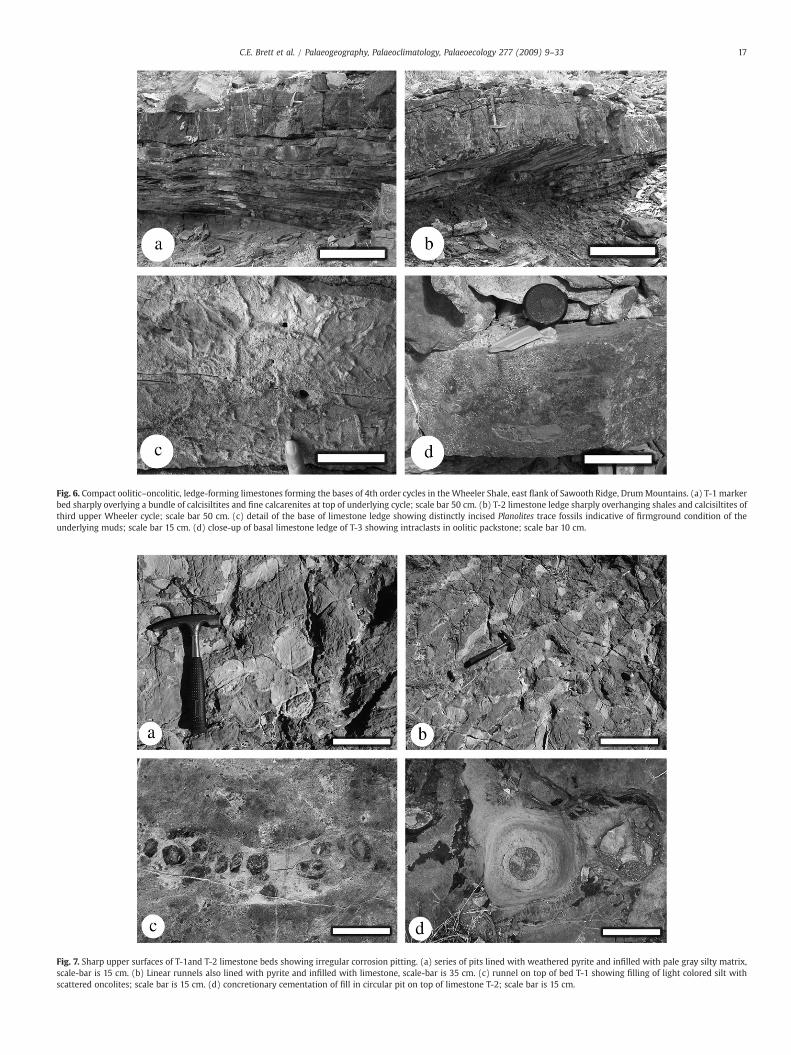
Fig. 6. Compact oolitic–oncolitic, ledge-forming limestones forming the bases of 4th order cycles in the Wheeler Shale, east flank of Sawooth Ridge, DrumMountains. (a) T-1 markerbed sharply overlying a bundle of calcisiltites and fine calcarenites at top of underlying cycle; scale bar 50 cm. (b) T-2 limestone ledge sharply overhanging shales and calcisiltites ofthird upper Wheeler cycle; scale bar 50 cm. (c) detail of the base of limestone ledge showing distinctly incised Planolites trace fossils indicative of firmground condition of theunderlying muds; scale bar 15 cm. (d) close-up of basal limestone ledge of T-3 showing intraclasts in oolitic packstone; scale bar 10 cm.
Fig. 7. Sharp upper surfaces of T-1and T-2 limestone beds showing irregular corrosion pitting. (a) series of pits lined with weathered pyrite and infilled with pale gray silty matrix,scale-bar is 15 cm. (b) Linear runnels also lined with pyrite and infilled with limestone, scale-bar is 35 cm. (c) runnel on top of bed T-1 showing filling of light colored silt withscattered oncolites; scale bar is 15 cm. (d) concretionary cementation of fill in circular pit on top of limestone T-2; scale bar is 15 cm.
17C.E. Brett et al. / Palaeogeography, Palaeoclimatology, Palaeoecology 277 (2009) 9–33
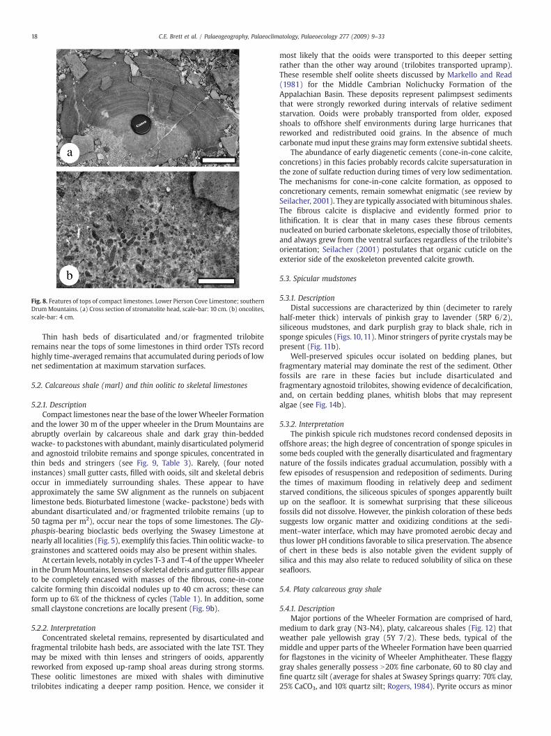
Fig. 8. Features of tops of compact limestones. Lower Pierson Cove Limestone; southernDrumMountains. (a) Cross section of stromatolite head, scale-bar: 10 cm. (b) oncolites,scale-bar: 4 cm.
18 C.E. Brett et al. / Palaeogeography, Palaeoclimatology, Palaeoecology 277 (2009) 9–33
Thin hash beds of disarticulated and/or fragmented trilobiteremains near the tops of some limestones in third order TSTs recordhighly time-averaged remains that accumulated during periods of lownet sedimentation at maximum starvation surfaces.
5.2. Calcareous shale (marl) and thin oolitic to skeletal limestones
5.2.1. DescriptionCompact limestones near the base of the lowerWheeler Formation
and the lower 30 m of the upper wheeler in the Drum Mountains areabruptly overlain by calcareous shale and dark gray thin-beddedwacke- to packstones with abundant, mainly disarticulated polymeridand agnostoid trilobite remains and sponge spicules, concentrated inthin beds and stringers (see Fig. 9, Table 3). Rarely, (four notedinstances) small gutter casts, filled with ooids, silt and skeletal debrisoccur in immediately surrounding shales. These appear to haveapproximately the same SW alignment as the runnels on subjacentlimestone beds. Bioturbated limestone (wacke- packstone) beds withabundant disarticulated and/or fragmented trilobite remains (up to50 tagma per m2), occur near the tops of some limestones. The Gly-phaspis-bearing bioclastic beds overlying the Swasey Limestone atnearly all localities (Fig. 5), exemplify this facies. Thin oolitic wacke- tograinstones and scattered ooids may also be present within shales.
At certain levels, notably in cycles T-3 and T-4 of the upperWheelerin the DrumMountains, lenses of skeletal debris and gutter fills appearto be completely encased with masses of the fibrous, cone-in-conecalcite forming thin discoidal nodules up to 40 cm across; these canform up to 6% of the thickness of cycles (Table 1). In addition, somesmall claystone concretions are locally present (Fig. 9b).
5.2.2. InterpretationConcentrated skeletal remains, represented by disarticulated and
fragmental trilobite hash beds, are associated with the late TST. Theymay be mixed with thin lenses and stringers of ooids, apparentlyreworked from exposed up-ramp shoal areas during strong storms.These oolitic limestones are mixed with shales with diminutivetrilobites indicating a deeper ramp position. Hence, we consider it
most likely that the ooids were transported to this deeper settingrather than the other way around (trilobites transported upramp).These resemble shelf oolite sheets discussed by Markello and Read(1981) for the Middle Cambrian Nolichucky Formation of theAppalachian Basin. These deposits represent palimpsest sedimentsthat were strongly reworked during intervals of relative sedimentstarvation. Ooids were probably transported from older, exposedshoals to offshore shelf environments during large hurricanes thatreworked and redistributed ooid grains. In the absence of muchcarbonate mud input these grains may form extensive subtidal sheets.
The abundance of early diagenetic cements (cone-in-cone calcite,concretions) in this facies probably records calcite supersaturation inthe zone of sulfate reduction during times of very low sedimentation.The mechanisms for cone-in-cone calcite formation, as opposed toconcretionary cements, remain somewhat enigmatic (see review bySeilacher, 2001). They are typically associated with bituminous shales.The fibrous calcite is displacive and evidently formed prior tolithification. It is clear that in many cases these fibrous cementsnucleated on buried carbonate skeletons, especially those of trilobites,and always grew from the ventral surfaces regardless of the trilobite'sorientation; Seilacher (2001) postulates that organic cuticle on theexterior side of the exoskeleton prevented calcite growth.
5.3. Spicular mudstones
5.3.1. DescriptionDistal successions are characterized by thin (decimeter to rarely
half-meter thick) intervals of pinkish gray to lavender (5RP 6/2),siliceous mudstones, and dark purplish gray to black shale, rich insponge spicules (Figs. 10, 11). Minor stringers of pyrite crystals may bepresent (Fig. 11b).
Well-preserved spicules occur isolated on bedding planes, butfragmentary material may dominate the rest of the sediment. Otherfossils are rare in these facies but include disarticulated andfragmentary agnostoid trilobites, showing evidence of decalcification,and, on certain bedding planes, whitish blobs that may representalgae (see Fig. 14b).
5.3.2. InterpretationThe pinkish spicule rich mudstones record condensed deposits in
offshore areas; the high degree of concentration of sponge spicules insome beds coupled with the generally disarticulated and fragmentarynature of the fossils indicates gradual accumulation, possibly with afew episodes of resuspension and redeposition of sediments. Duringthe times of maximum flooding in relatively deep and sedimentstarved conditions, the siliceous spicules of sponges apparently builtup on the seafloor. It is somewhat surprising that these siliceousfossils did not dissolve. However, the pinkish coloration of these bedssuggests low organic matter and oxidizing conditions at the sedi-ment–water interface, which may have promoted aerobic decay andthus lower pH conditions favorable to silica preservation. The absenceof chert in these beds is also notable given the evident supply ofsilica and this may also relate to reduced solubility of silica on theseseafloors.
5.4. Platy calcareous gray shale
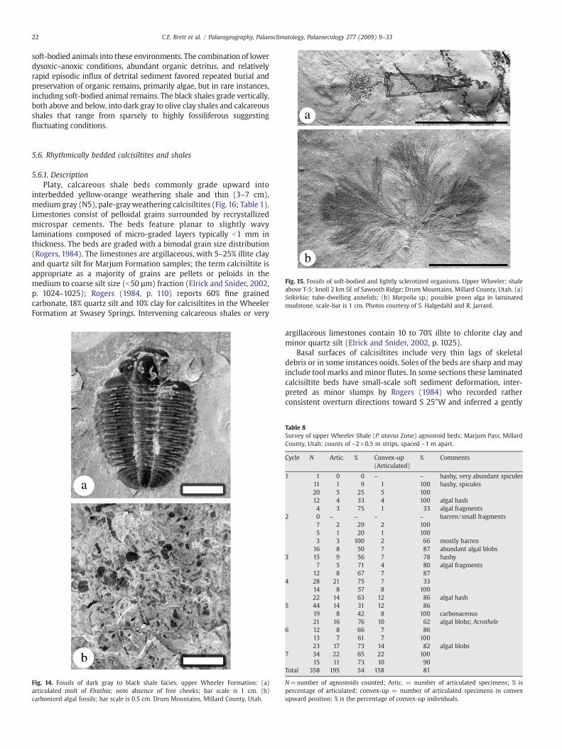
5.4.1. DescriptionMajor portions of the Wheeler Formation are comprised of hard,
medium to dark gray (N3-N4), platy, calcareous shales (Fig. 12) thatweather pale yellowish gray (5Y 7/2). These beds, typical of themiddle and upper parts of the Wheeler Formation have been quarriedfor flagstones in the vicinity of Wheeler Amphitheater. These flaggygray shales generally possess N20% fine carbonate, 60 to 80 clay andfine quartz silt (average for shales at Swasey Springs quarry: 70% clay,25% CaCO3, and 10% quartz silt; Rogers, 1984). Pyrite occurs as minor
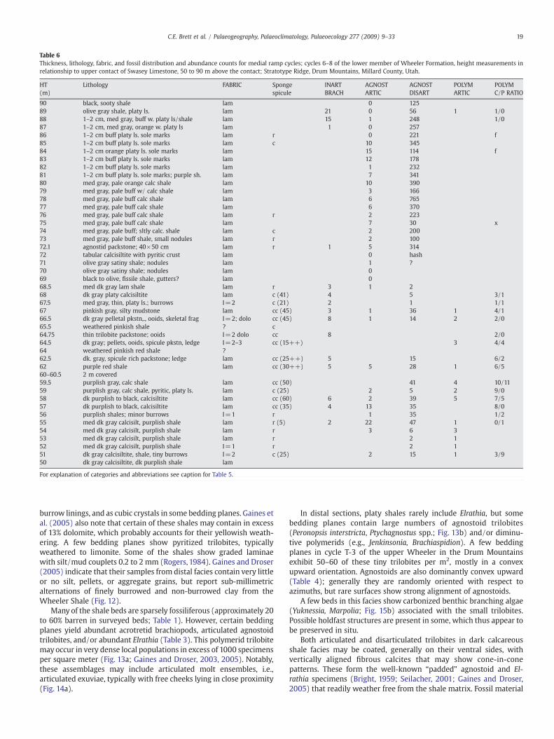
Table 6Thickness, lithology, fabric, and fossil distribution and abundance counts for medial ramp cycles; cycles 6–8 of the lower member of Wheeler Formation, height measurements inrelationship to upper contact of Swasey Limestone, 50 to 90 m above the contact; Stratotype Ridge, Drum Mountains, Millard County, Utah.
HT Lithology FABRIC Spongespicule
INARTBRACH
AGNOSTARTIC
AGNOSTDISART
POLYMARTIC
POLYMC/P RATIO(m)
90 black, sooty shale lam 0 12589 olive gray shale, platy ls. lam 21 0 56 1 1/088 1–2 cm, med gray, buff w. platy ls/shale lam 15 1 248 1/087 1–2 cm, med gray, orange w. platy ls lam 1 0 25786 1–2 cm buff platy ls. sole marks lam r 0 221 f85 1–2 cm buff platy ls. sole marks lam c 10 34584 1–2 cm orange platy ls. sole marks lam 15 114 f83 1–2 cm buff platy ls. sole marks lam 12 17882 1–2 cm buff platy ls. sole marks lam 1 23281 1–2 cm buff platy ls. sole marks; purple sh. lam 7 34180 med gray, pale orange calc shale lam 10 39079 med gray, pale buff w/ calc shale lam 3 16678 med gray, pale buff calc shale lam 6 76577 med gray, pale buff calc shale lam 6 37076 med gray, pale buff calc shale lam r 2 22375 med gray, pale buff calc shale lam 7 30 x74 med gray, pale buff; sltly calc. shale lam c 2 20073 med gray, pale buff shale, small nodules lam r 2 10072.1 agnostid packstone; 40×50 cm lam r 1 5 31472 tabular calcisiltite with pyritic crust lam 0 hash71 olive gray satiny shale; nodules lam 1 ?70 olive gray satiny shale; nodules lam 069 black to olive, fissile shale, gutters? lam 068.5 med dk gray lam shale lam r 3 1 268 dk gray platy calcisiltite lam c (41) 4 5 3/167.5 med gray, thin, platy ls.; burrows I=2 c (21) 2 1 1/167 pinkish gray, silty mudstone lam cc (45) 3 1 36 1 4/166.5 dk gray pelletal pkstn,., ooids, skeletal frag I=2; dolo cc (45) 8 1 14 2 2/065.5 weathered pinkish shale ? c64.75 thin trilobite packstone; ooids I=2 dolo cc 8 2/064.5 dk gray; pellets, ooids, spicule pkstn, ledge I=2–3 cc (15++) 3 4/464 weathered pinkish red shale ?62.5 dk. gray, spicule rich packstone; ledge lam cc (25++) 5 15 6/262 purple red shale lam cc (30++) 5 5 28 1 6/560–60.5 2 m covered59.5 purplish gray, calc shale lam cc (50) 41 4 10/1159 purplish gray, calc shale, pyritic, platy ls. lam c (25) 2 5 2 9/058 dk purplish to black, calcisiltite lam cc (60) 6 2 39 5 7/557 dk purplish to black, calcisiltite lam cc (35) 4 13 35 8/056 purplish shales; minor burrows I=1 r 1 35 1/255 med dk gray calcisilt, purplish shale lam r (5) 2 22 47 1 0/154 med dk gray calcisilt, purplish shale lam r 3 6 353 med dk gray calcisilt, purplish shale lam r 2 152 med dk gray calcisilt, purplish shale I=1 r 2 151 dk gray calcisiltite, shale, tiny burrows I=2 c (25) 2 15 1 3/950 dk gray calcisiltite, dk purplish shale lam
For explanation of categories and abbreviations see caption for Table 5.
19C.E. Brett et al. / Palaeogeography, Palaeoclimatology, Palaeoecology 277 (2009) 9–33
burrow linings, and as cubic crystals in some bedding planes. Gaines etal. (2005) also note that certain of these shales may contain in excessof 13% dolomite, which probably accounts for their yellowish weath-ering. A few bedding planes show pyritized trilobites, typicallyweathered to limonite. Some of the shales show graded laminaewith silt/mud couplets 0.2 to 2 mm (Rogers, 1984). Gaines and Droser(2005) indicate that their samples from distal facies contain very littleor no silt, pellets, or aggregate grains, but report sub-millimetricalternations of finely burrowed and non-burrowed clay from theWheeler Shale (Fig. 12).
Many of the shale beds are sparsely fossiliferous (approximately 20to 60% barren in surveyed beds; Table 1). However, certain beddingplanes yield abundant acrotretid brachiopods, articulated agnostoidtrilobites, and/or abundant Elrathia (Table 3). This polymerid trilobitemay occur in very dense local populations in excess of 1000 specimensper square meter (Fig. 13a; Gaines and Droser, 2003, 2005). Notably,these assemblages may include articulated molt ensembles, i.e.,articulated exuviae, typically with free cheeks lying in close proximity(Fig. 14a).
In distal sections, platy shales rarely include Elrathia, but somebedding planes contain large numbers of agnostoid trilobites(Peronopsis interstricta, Ptychagnostus spp.; Fig. 13b) and/or diminu-tive polymerids (e.g., Jenkinsonia, Brachiaspidion). A few beddingplanes in cycle T-3 of the upper Wheeler in the Drum Mountainsexhibit 50–60 of these tiny trilobites per m2, mostly in a convexupward orientation. Agnostoids are also dominantly convex upward(Table 4); generally they are randomly oriented with respect toazimuths, but rare surfaces show strong alignment of agnostoids.
A few beds in this facies show carbonized benthic branching algae(Yuknessia, Marpolia; Fig. 15b) associated with the small trilobites.Possible holdfast structures are present in some, which thus appear tobe preserved in situ.
Both articulated and disarticulated trilobites in dark calcareousshale facies may be coated, generally on their ventral sides, withvertically aligned fibrous calcites that may show cone-in-conepatterns. These form the well-known “padded” agnostoid and El-rathia specimens (Bright, 1959; Seilacher, 2001; Gaines and Droser,2005) that readily weather free from the shale matrix. Fossil material
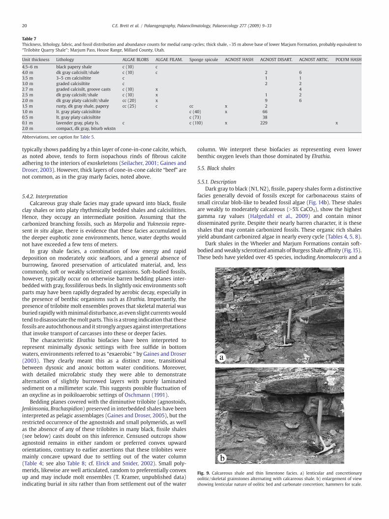
Table 7Thickness, lithology, fabric, and fossil distribution and abundance counts for medial ramp cycles; thick shale, ~35 m above base of lower Marjum Formation, probably equivalent to“Trilobite Quarry Shale”; Marjum Pass, House Range, Millard County, Utah.
Unit thickness Lithology ALGAE BLOBS ALGAE FILAM. Sponge spicule AGNOST HASH AGNOST DISART. AGNOST ARTIC. POLYM HASH
4.5–6 m black papery shale c (10) c4.0 m dk gray cailcisilt/shale c (10) c 2 63.5 m 3–5 cm calcisiltite c 1 13.0 m graded calcisiltite c 2 22.7 m graded calcisilt, groove casts c (10) x 42.5 m dk gray calcisilt/shale c (10) x 1 22.0 m dk gray platy calcisilt/shale cc (20) x 9 61.5 m rusty, dk gray shale, papery cc (25) c cc x 21.0 m lt. gray platy calcisiltite c (40) x 660.5 m lt. gray platy calcisiltite c (73) 380.1 m lavender gray, platy ls. c c (110) x 229 x2.0 m compact, dk gray, biturb wkstn
Abbreviations, see caption for Table 5.
20 C.E. Brett et al. / Palaeogeography, Palaeoclimatology, Palaeoecology 277 (2009) 9–33
typically shows padding by a thin layer of cone-in-cone calcite, which,as noted above, tends to form isopachous rinds of fibrous calciteadhering to the interiors of exoskeletons (Seilacher, 2001; Gaines andDroser, 2003). However, thick layers of cone-in-cone calcite “beef” arenot common, as in the gray marly facies, noted above.
Fig. 9. Calcareous shale and thin limestone facies. a) lenticular and concretionaryoolitic/skeletal grainstones alternating with calcareous shale. b) enlargement of viewshowing lenticular nature of oolitic bed and carbonate concretion; hammers for scale.
5.4.2. InterpretationCalcareous gray shale facies may grade upward into black, fissile
clay shales or into platy rhythmically bedded shales and calcisilitites.Hence, they occupy an intermediate position. Assuming that thecarbonized branching fossils, such as Marpolia and Yuknessia repre-sent in situ algae, there is evidence that these facies accumulated inthe deeper euphotic zone environments, hence, water depths wouldnot have exceeded a few tens of meters.
In gray shale facies, a combination of low energy and rapiddeposition on moderately oxic seafloors, and a general absence ofburrowing, favored preservation of articulated material, and, lesscommonly, soft or weakly sclerotized organisms. Soft-bodied fossils,however, typically occur on otherwise barren bedding planes inter-beddedwith gray, fossiliferous beds. In slightly oxic environments softparts may have been rapidly degraded by aerobic decay, especially inthe presence of benthic organisms such as Elrathia. Importantly, thepresence of trilobite molt ensembles proves that skeletal material wasburied rapidlywithminimal disturbance, as even slight currentswouldtend todisassociate themolt parts. This is a strong indication that thesefossils are autochthonous and it stronglyargues against interpretationsthat invoke transport of carcasses into these or deeper facies.
The characteristic Elrathia biofacies have been interpreted torepresent minimally dysoxic settings with free sulfide in bottomwaters, environments referred to as “exaerobic “ by Gaines and Droser(2003). They clearly meant this as a distinct zone, transitionalbetween dysoxic and anoxic bottom water conditions. Moreover,with detailed microfabric study they were able to demonstratealternation of slightly burrowed layers with purely laminatedsediment on a millimeter scale. This suggests possible fluctuation ofan oxycline as in poikiloaerobic settings of Oschmann (1991).
Bedding planes covered with the diminutive trilobite (agnostoids,Jenkinsonia, Brachaspidion) preserved in interbedded shales have beeninterpreted as pelagic assemblages (Gaines and Droser, 2005), but therestricted occurrence of the agnostoids and small polymerids, as wellas the absence of any of these trilobites in many black, fissile shales(see below) casts doubt on this inference. Censused outcrops showagnostoid remains in either random or preferred convex upwardorientations, contrary to earlier assertions that these trilobites weremainly concave upward due to settling out of the water column(Table 4; see also Table 8; cf. Elrick and Snider, 2002). Small poly-merids, likewise are well articulated, random to preferentially convexup and may include molt ensembles (T. Kramer, unpublished data)indicating burial in situ rather than from settlement out of the water
column. We interpret these biofacies as representing even lowerbenthic oxygen levels than those dominated by Elrathia.
5.5. Black shales
5.5.1. DescriptionDark gray to black (N1, N2), fissile, papery shales form a distinctive
facies generally devoid of fossils except for carbonaceous stains ofsmall circular blob-like to beaded fossil algae (Fig. 14b). These shalesare weakly to moderately calcareous (N5% CaCO3), show the highestgamma ray values (Halgedahl et al., 2009) and contain minordisseminated pyrite. Despite their nearly barren character, it is theseshales that may contain carbonized fossils. These organic rich shalesyield abundant carbonized algae in nearly every cycle (Tables 4, 5, 8).
Dark shales in the Wheeler and Marjum Formations contain soft-bodied andweakly sclerotized animals of Burgess Shale affinity (Fig.15).These beds have yielded over 45 species, including Anomalocaris and a
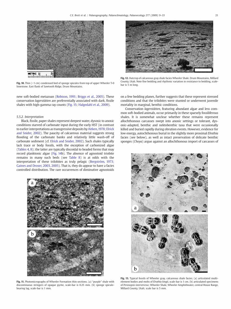
Fig. 10. Thin (b1 cm) condensed bed of sponge spicules from top of upper Wheeler T-0limestone. East flank of Sawtooth Ridge, Drum Mountains.
Fig. 12. Outcrop of calcareous gray shale faciesWheeler Shale. DrumMountains, MillardCounty, Utah. Note fine bedding and rhythmic variation in resistance to bedding, scale-bar is 5 m long.
21C.E. Brett et al. / Palaeogeography, Palaeoclimatology, Palaeoecology 277 (2009) 9–33
new soft-bodied metazoan (Robison, 1991; Briggs et al., 2005). Theseconservation lagerstätten are preferentially associated with dark, fissileshales with high-gamma ray counts (Fig. 15; Halgedahl et al., 2009).
5.5.2. InterpretationBlack, fissile, paper shales represent deepest water, dysoxic to anoxic
conditions starved of carbonate input during the early HST (in contrastto earlier interpretations as transgressive deposits byAitken,1978; Elrickand Snider, 2002). The paucity of calcareous material suggests strongflooding of the carbonate banks and relatively little wash-off ofcarbonate sediment (cf. Elrick and Snider, 2002). Such shales typicallylack trace or body fossils, with the exception of carbonized algae(Tables 4, 8); the latter are typically discoidal to beaded forms that mayrecord planktonic algae (Fig. 14b). The absence of agnostoid triobiteremains in many such beds (see Table 8) is at odds with theinterpretation of these trilobites as truly pelagic (Bergström, 1973;Gaines and Droser, 2003, 2005). That is, they do appear to have a faciescontrolled distribution. The rare occurrences of diminutive agnostoids
Fig. 11. Photomicrographs of Wheeler Formation thin-sections. (a) “purple” shale withdiscontinuous stringers of opaque pyrite, scale-bar is 0.25 mm. (b) sponge spicule-bearing lag, scale-bar is 1 mm.
on a few bedding planes, further suggests that these represent stressedconditions and that the trilobites were stunted or underwent juvenilemortality in marginal, benthic conditions.
Conservation lagerstätten, featuring abundant algae and less com-mon soft-bodied animals, occur primarily in these sparsely fossiliferousshales. It is somewhat unclear whether these remains representallochthonous carcasses swept into anoxic settings or tolerant, dys-oxic-adapted, benthic and nektobenthic taxa that were occasionallykilled and buried rapidly during obrution events. However, evidence forlow energy, autochthonous burial in the slightly more proximal Elrathiafacies (see below), as well as intact preservation of delicate benthicsponges (Choya) argue against an allochthonous import of carcasses of
Fig. 13. Typical fossils of Wheeler gray, calcareous shale facies. (a) articulated multi-element bodies and molts of Elrathia kingii, scale-bar is 1 cm. (b) articulated specimensof Peronopsis interstrictus; Wheeler Shale, Wheeler Amphitheater, central House Range,Millard County, Utah; scale bar is 5 mm.
22 C.E. Brett et al. / Palaeogeography, Palaeoclimatology, Palaeoecology 277 (2009) 9–33
soft-bodied animals into these environments. The combination of lowerdysoxic–anoxic conditions, abundant organic detritus, and relativelyrapid episodic influx of detrital sediment favored repeated burial andpreservation of organic remains, primarily algae, but in rare instances,including soft-bodied animal remains. The black shales grade vertically,both above and below, into dark gray to olive clay shales and calcareousshales that range from sparsely to highly fossiliferous suggestingfluctuating conditions.
Fig. 15. Fossils of soft-bodied and lightly sclerotized organisms. Upper Wheeler; shaleabove T-5; knoll 2 km SE of Sawooth Ridge; Drum Mountains, Millard County, Utah. (a)Selkirkia; tube-dwelling annelids; (b) Marpolia sp.; possible green alga in laminatedmudstone, scale-bar is 1 cm. Photos courtesy of S. Halgedahl and R. Jarrard.
5.6. Rhythmically bedded calcisiltites and shales
5.6.1. DescriptionPlaty, calcareous shale beds commonly grade upward into
interbedded yellow-orange weathering shale and thin (3–7 cm),medium gray (N5), pale-grayweathering calcisiltites (Fig.16; Table 1).Limestones consist of pelloidal grains surrounded by recrystallizedmicrospar cements. The beds feature planar to slightly wavylaminations composed of micro-graded layers typically b1 mm inthickness. The beds are graded with a bimodal grain size distribution(Rogers, 1984). The limestones are argillaceous, with 5–25% illite clayand quartz silt for Marjum Formation samples; the term calcisiltite isappropriate as a majority of grains are pellets or peloids in themedium to coarse silt size (b50 µm) fraction (Elrick and Snider, 2002,p. 1024–1025); Rogers (1984, p. 110) reports 60% fine grainedcarbonate, 18% quartz silt and 10% clay for calcisiltites in the WheelerFormation at Swasey Springs. Intervening calcareous shales or very
Fig. 14. Fossils of dark gray to black shale facies, upper Wheeler Formation: (a)articulated molt of Elrathia; note absence of free cheeks; bar scale is 1 cm. (b)carbonized algal fossils; bar scale is 0.5 cm. Drum Mountains, Millard County, Utah.
argillaceous limestones contain 10 to 70% illite to chlorite clay andminor quartz silt (Elrick and Snider, 2002, p. 1025).
Basal surfaces of calcisiltites include very thin lags of skeletaldebris or in some instances ooids. Soles of the beds are sharp and mayinclude tool marks and minor flutes. In some sections these laminatedcalcisiltite beds have small-scale soft sediment deformation, inter-preted as minor slumps by Rogers (1984) who recorded ratherconsistent overturn directions toward S 25°W and inferred a gently
Table 8Survey of upper Wheeler Shale (P. atavus Zone) agnostoid beds; Marjum Pass, MillardCounty, Utah; counts of ~2×0.5 m strips, spaced ~1 m apart.
Cycle N Artic. % Convex-up(Articulated)
% Comments
1 1 0 0 – – hashy, very abundant spicules11 1 9 1 100 hashy, spicules20 5 25 5 10012 4 33 4 100 algal hash4 3 75 1 33 algal fragments
2 0 – – – – barren/small fragments7 2 29 2 1005 1 20 1 1003 3 100 2 66 mostly barren
16 8 50 7 87 abundant algal blobs3 15 9 56 7 78 hashy
7 5 71 4 80 algal fragments12 8 67 7 87
4 28 21 75 7 3314 8 57 8 10022 14 63 12 86 algal hash
5 44 14 31 12 8619 8 42 8 100 carbonaceous21 16 76 10 62 algal blobs; Acrothele
6 12 8 66 7 8613 7 61 7 10023 17 73 14 82 algal blobs
7 34 22 65 22 10015 11 73 10 90
Total 358 195 54 158 81
N=number of agnostoids counted; Artic. = number of articulated specimens; % ispercentage of articulated; convex-up = number of articulated specimens in convexupward position; % is the percentage of convex-up individuals.
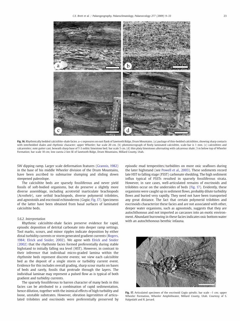
Fig.16. Rhythmically bedded calcisiltite-shale facies. a–c exposures on east flank of Sawtooth Ridge, DrumMountains. (a) package of thin-bedded calcisiltites, showing sharp contactswith interbedded shales and rhythmic character; upper Wheeler; bar scale 20 cm. (b) photomicrograph of finely laminated calcisiltite, scale-bar is 1 mm. (c) calcisiltites andcalcarenites; note gutter cast, beneath sharp base of T-3 oolitic limestone bed; bar scale 5 cm. (d) thin platy limestones alternating with calcareous shale; 3 m below top of WheelerFormation; bar scale 10 cm; low cuesta 2 km SE of Sawtooth Ridge, Drum Mountains, Millard County, Utah.
Fig. 17. Articulated specimen of the eocrinoid Gogia spiralis; bar scale ~1 cm; upperWheeler Formation, Wheeler Amphitheater, Millard County, Utah. Courtesy of S.Halgedahl and R. Jarrard.
23C.E. Brett et al. / Palaeogeography, Palaeoclimatology, Palaeoecology 277 (2009) 9–33
SW dipping ramp. Larger scale deformation features (Grannis, 1982)in the base of his middle Wheeler division of the Drum Mountains,have been ascribed to submarine slumping and sliding downsteepened paleoslope.
The calcisiltite beds are sparsely fossiliferous and never yieldfossils of soft-bodied organisms, but do preserve a slightly morediverse assemblage, including acrotretid inarticulate brachiopods(Acrothele), rare orthid brachiopods, diverse polymerid trilobites,and agnostoids and eocrinoid echinoderms (Gogia; Fig.17). Specimensof the latter have been obtained from basal surfaces of laminatedcalcisiltite beds.
5.6.2. InterpretationRhythmic calcisiltite-shale facies preserve evidence for rapid,
episodic deposition of detrital carbonate into deeper ramp settings.Tool marks, scours, and minor ripples indicate deposition by eitherdistal turbidity currents or storm generated gradient currents (Rogers,1984; Elrick and Snider, 2002). We agree with Elrick and Snider(2002) that the rhythmite facies formed preferentially during stablehighstand to initially falling sea level (HST). However, in contrast totheir inference that individual micro-graded lamina within therhythmite beds represent discrete events; we view each calcisiltitebed as the deposit of a single storm or turbidity current event.Evidence for this includes overall grading, sharp scour marks on basesof beds and rarely, fossils that protrude through the layers. Theindividual laminae may represent a pulsed flow as is typical of bothgradient and turbidity currents.
The sparsely fossiliferous to barren character of many beds in thisfacies can be attributed to a combination of rapid sedimentation,hence dilution, together with the inimical effects of high turbidity andloose, unstable substrates. However, obrution lagerstätten of articu-lated trilobites and eocrinoids were preferentially preserved by
episodic mud tempestites/turbidites on more oxic seafloors duringthe later highstand (see Powell et al., 2003). These sediments recordlate HST to falling stage (FSST) carbonate shedding. The high sedimentinflux typical of FSSTs resulted in sparsely fossiliferous strata.However, in rare cases, well-articulated remains of eocrinoids andtrilobites occur on the undersides of beds (Fig. 17). Evidently, theseorganismswere caught up in sediment flows, probably dilute turbidityflows and buried very rapidly. They need not have been transportedany great distance. The fact that certain polymerid trilobites andeocrinoids characterize these facies and are not associated with other,deeper water organisms, such as agnostoids, suggests that they areautochthonous and not imported as carcasses into an exotic environ-ment. Abundant burrowing in these facies indicates oxic bottomwaterwith an autochthonous benthic infauna.
Fig. 18. Platy calcareous shale and bioturbated calcisiltite facies. (a) platy calcareousshales. (b) heavily bioturbated calcisiltites at top of Wheeler Formation; low cuesta2 km SE of Sawtooth Ridge, Drum Mountains, Millard County, Utah.
Fig. 19. Third-order sequence stratigraphic interpretation of Middle Cambrian Swasey–Wheeler-lower Marjum succession of the central House Range, Millard County, Utah.Abbreviations: SB: sequence boundary; MFS: maximum flooding surface; MSS:maximum sediment starvation surface. Systems tracts (STs): LST: lowstand systemstract; eTST early transgressive; lTST: late transgressive; HST: highstand; FSST: fallingstage.
24 C.E. Brett et al. / Palaeogeography, Palaeoclimatology, Palaeoecology 277 (2009) 9–33
5.7. Bioturbated calcisiltites/calcarenites
5.7.1. DescriptionThe rhythmites pass upward into thin (1–5 cm) burrow mottled
wavy to nodular bedded calcisiltites and fine grained calcarenites withlenticular pack- to grainstones (Fig. 18; Table 1). The latter arecomprised of oolitic, pelletal, and skeletal grains (trilobite fragments,echinoderm debris, orthid brachiopods or stenothecids. Beds showsharp bases with scour features and in a few instances the skeletal andooid grains are concentrated in small-scale gutter casts (Fig. 17c).Fossil material is typically disarticulated, fragmented and concen-trated at the bases of beds. Beds finer than calcarenites are typicallyburrowed (ichnofabric index 2 to 4). Burrows are infilled with buffweathering dolomitic silts, which contrast with the pale to mediumgray color of the calcisiltites and fine calcarenites (Fig. 18b). Burrowedbeds are rather closely stacked with only argillaceous partingsseparating them.
Packages of burrowed calcisiltites and calcarenites are sharply setoff from underlying shales and rhythmically bedded calcilsilites at flatto slightly undulatory boundaries. The tops of these intervals aresharply defined at the bases of the compact calcarenitic limestones.These are coarse, sandy textured, compact pack- to grainstones, withabundant fossil fragments including abundant sponge spicules, largepeloids, and scattered ooids.
5.7.2. InterpretationThe bioturbation of these beds indicates fully oxygenated bottom
water and perhaps relatively lowered rates of sedimentation and/orbypass of fine-grained sediments. The presence of a sharp basal contactto somebundlesof burrowed calcisiltite to calcarenite indicates frequenttouch-down of storm waves in a still relatively low sedimentation
setting. We interpret such surfaces as forced regression surfaces.Bioturbated silty limestones and calcarenites would then record fallingstage deposits, accumulated during amore rapid phase of sea level drop.The presence of gutter casts and graded beds in some of the shallowerportions of this facies strongly suggests stormwave touch down on theseafloor. The FSST deposits are terminated by a sharply erosive sequenceboundary recording maximum lowstand.
More compact, slightly coarser fine-grained calcarenites are inter-preted as reworked lag deposits, analogous to, but slightly deeper than,compact oolitic limestones. These beds are interpreted as initial trans-gressive lag deposits.
6. Cyclicity in the Wheeler and Marjum formations
The Middle Cambrian interval of the Great Basin is divisible intosedimentary cycles at three scales (Schneider, 2000), each with similarmotifs. The largest cycles are of formational scale, 30 to 100m thick, andinterpreted as 3rd order composite depositional sequences or “grandcycles” (Fig. 19). Cycles of 2 to 20 m thickness, generally comprised ofseveral meter-scale cycles, display a typical sequence-like pattern (see
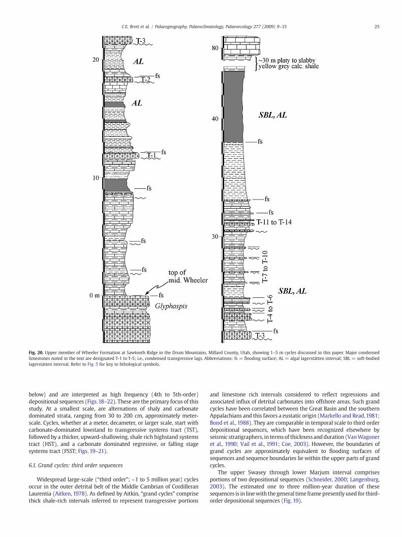
Fig. 20. Upper member of Wheeler Formation at Sawtooth Ridge in the Drum Mountains, Millard County, Utah, showing 1–5 m cycles discussed in this paper. Major condensedlimestones noted in the text are designated T-1 to T-5; i.e., condensed transgressive lags. Abbreviations: fs = flooding surface; AL = algal lagerstätten interval; SBL = soft-bodiedlagerstätten interval. Refer to Fig. 5 for key to lithological symbols.
25C.E. Brett et al. / Palaeogeography, Palaeoclimatology, Palaeoecology 277 (2009) 9–33
below) and are interpreted as high frequency (4th to 5th-order)depositional sequences (Figs.18–22). These are the primary focus of thisstudy. At a smallest scale, are alternations of shaly and carbonatedominated strata, ranging from 30 to 200 cm, approximately meter-scale. Cycles, whether at a meter, decameter, or larger scale, start withcarbonate-dominated lowstand to transgressive systems tract (TST),followed by a thicker, upward-shallowing, shale rich highstand systemstract (HST), and a carbonate dominated regressive, or falling stagesystems tract (FSST; Figs. 19–21).
6.1. Grand cycles: third order sequences
Widespread large-scale (“third order”; ~1 to 5 million year) cyclesoccur in the outer detrital belt of the Middle Cambrian of CordilleranLaurentia (Aitken, 1978). As defined by Aitkin, “grand cycles” comprisethick shale-rich intervals inferred to represent transgressive portions
and limestone rich intervals considered to reflect regressions andassociated influx of detrital carbonates into offshore areas. Such grandcycles have been correlated between the Great Basin and the southernAppalachians and this favors a eustatic origin (Markello and Read,1981;Bond et al., 1988). They are comparable in temporal scale to third orderdepositional sequences, which have been recognized elsewhere byseismic stratigraphers, in termsof thickness andduration (VanWagoneret al., 1990; Vail et al., 1991; Coe, 2003). However, the boundaries ofgrand cycles are approximately equivalent to flooding surfaces ofsequences and sequence boundaries lie within the upper parts of grandcycles.
The upper Swasey through lower Marjum interval comprisesportions of two depositional sequences (Schneider, 2000; Langenburg,2003). The estimated one to three million-year duration of thesesequences is in linewith the general time framepresently used for third-order depositional sequences (Fig. 19).
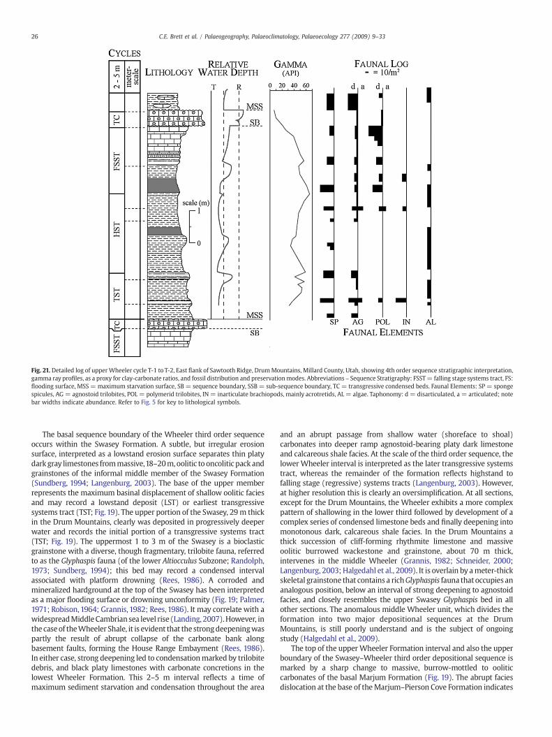
Fig. 21. Detailed log of upper Wheeler cycle T-1 to T-2, East flank of Sawtooth Ridge, DrumMountains, Millard County, Utah, showing 4th order sequence stratigraphic interpretation,gamma ray profiles, as a proxy for clay-carbonate ratios, and fossil distribution and preservationmodes. Abbreviations – Sequence Stratigraphy: FSST= falling stage systems tract, FS:flooding surface, MSS =maximum starvation surface, SB = sequence boundary, SSB = sub-sequence boundary, TC = transgressive condensed beds. Faunal Elements: SP = spongespicules, AG = agnostoid trilobites, POL = polymerid trilobites, IN = inarticulate brachiopods, mainly acrotretids, AL = algae. Taphonomy: d = disarticulated, a = articulated; notebar widths indicate abundance. Refer to Fig. 5 for key to lithological symbols.
26 C.E. Brett et al. / Palaeogeography, Palaeoclimatology, Palaeoecology 277 (2009) 9–33
The basal sequence boundary of the Wheeler third order sequenceoccurs within the Swasey Formation. A subtle, but irregular erosionsurface, interpreted as a lowstand erosion surface separates thin platydark gray limestones frommassive,18–20m,oolitic to oncolitic pack andgrainstones of the informal middle member of the Swasey Formation(Sundberg, 1994; Langenburg, 2003). The base of the upper memberrepresents the maximum basinal displacement of shallow oolitic faciesand may record a lowstand deposit (LST) or earliest transgressivesystems tract (TST; Fig. 19). The upper portion of the Swasey, 29m thickin the Drum Mountains, clearly was deposited in progressively deeperwater and records the initial portion of a transgressive systems tract(TST; Fig. 19). The uppermost 1 to 3 m of the Swasey is a bioclasticgrainstone with a diverse, though fragmentary, trilobite fauna, referredto as the Glyphaspis fauna (of the lower Altiocculus Subzone; Randolph,1973; Sundberg, 1994); this bed may record a condensed intervalassociated with platform drowning (Rees, 1986). A corroded andmineralized hardground at the top of the Swasey has been interpretedas a major flooding surface or drowning unconformity (Fig. 19; Palmer,1971; Robison, 1964; Grannis, 1982; Rees, 1986). It may correlate with awidespreadMiddleCambrian sea level rise (Landing, 2007).However, inthe caseof theWheeler Shale, it is evident that the strongdeepeningwaspartly the result of abrupt collapse of the carbonate bank alongbasement faults, forming the House Range Embayment (Rees, 1986).In either case, strong deepening led to condensationmarked by trilobitedebris, and black platy limestones with carbonate concretions in thelowest Wheeler Formation. This 2–5 m interval reflects a time ofmaximum sediment starvation and condensation throughout the area
and an abrupt passage from shallow water (shoreface to shoal)carbonates into deeper ramp agnostoid-bearing platy dark limestoneand calcareous shale facies. At the scale of the third order sequence, thelower Wheeler interval is interpreted as the later transgressive systemstract, whereas the remainder of the formation reflects highstand tofalling stage (regressive) systems tracts (Langenburg, 2003). However,at higher resolution this is clearly an oversimplification. At all sections,except for the Drum Mountains, the Wheeler exhibits a more complexpattern of shallowing in the lower third followed by development of acomplex series of condensed limestone beds and finally deepening intomonotonous dark, calcareous shale facies. In the Drum Mountains athick succession of cliff-forming rhythmite limestone and massiveoolitic burrowed wackestone and grainstone, about 70 m thick,intervenes in the middle Wheeler (Grannis, 1982; Schneider, 2000;Langenburg, 2003; Halgedahl et al., 2009). It is overlain by ameter-thickskeletal grainstone that contains a richGlyphaspis fauna thatoccupies ananalogous position, below an interval of strong deepening to agnostoidfacies, and closely resembles the upper Swasey Glyphaspis bed in allother sections. The anomalous middle Wheeler unit, which divides theformation into two major depositional sequences at the DrumMountains, is still poorly understand and is the subject of ongoingstudy (Halgedahl et al., 2009).
The top of the upperWheeler Formation interval and also the upperboundary of the Swasey–Wheeler third order depositional sequence ismarked by a sharp change to massive, burrow-mottled to ooliticcarbonates of the basal Marjum Formation (Fig. 19). The abrupt faciesdislocation at the base of theMarjum–Pierson Cove Formation indicates
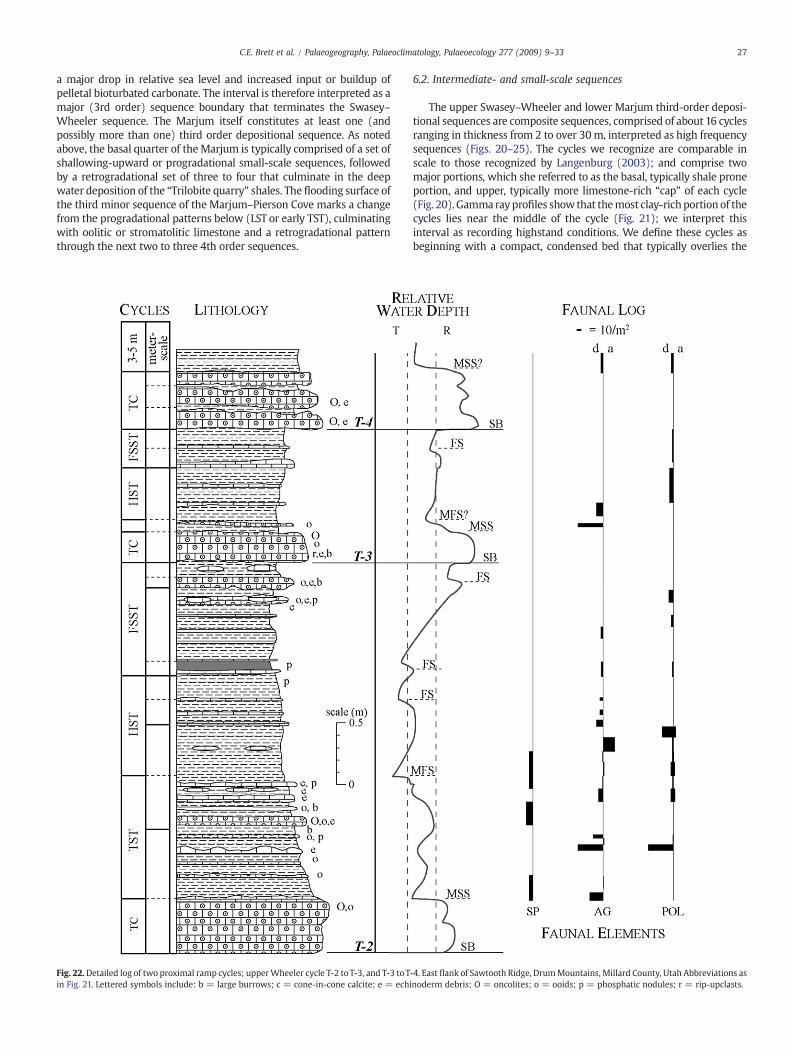
27C.E. Brett et al. / Palaeogeography, Palaeoclimatology, Palaeoecology 277 (2009) 9–33
a major drop in relative sea level and increased input or buildup ofpelletal bioturbated carbonate. The interval is therefore interpreted as amajor (3rd order) sequence boundary that terminates the Swasey–Wheeler sequence. The Marjum itself constitutes at least one (andpossibly more than one) third order depositional sequence. As notedabove, the basal quarter of the Marjum is typically comprised of a set ofshallowing-upward or progradational small-scale sequences, followedby a retrogradational set of three to four that culminate in the deepwater deposition of the “Trilobite quarry” shales. The flooding surface ofthe third minor sequence of the Marjum–Pierson Cove marks a changefrom the progradational patterns below (LST or early TST), culminatingwith oolitic or stromatolitic limestone and a retrogradational patternthrough the next two to three 4th order sequences.
Fig. 22.Detailed log of two proximal ramp cycles; upperWheeler cycle T-2 toT-3, and T-3 toTin Fig. 21. Lettered symbols include: b = large burrows; c = cone-in-cone calcite; e = echi
6.2. Intermediate- and small-scale sequences
The upper Swasey–Wheeler and lower Marjum third-order deposi-tional sequences are composite sequences, comprised of about 16 cyclesranging in thickness from 2 to over 30 m, interpreted as high frequencysequences (Figs. 20–25). The cycles we recognize are comparable inscale to those recognized by Langenburg (2003); and comprise twomajor portions, which she referred to as the basal, typically shale proneportion, and upper, typically more limestone-rich “cap” of each cycle(Fig. 20). Gamma ray profiles show that themost clay-rich portion of thecycles lies near the middle of the cycle (Fig. 21); we interpret thisinterval as recording highstand conditions. We define these cycles asbeginning with a compact, condensed bed that typically overlies the
-4. East flank of Sawtooth Ridge, DrumMountains, Millard County, Utah Abbreviations asnoderm debris; O = oncolites; o = ooids; p = phosphatic nodules; r = rip-upclasts.
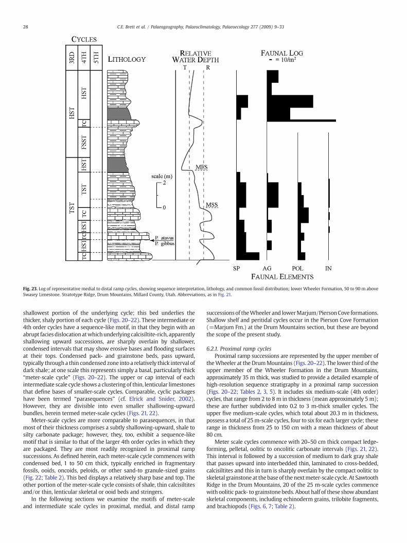
Fig. 23. Log of representative medial to distal ramp cycles, showing sequence interpretation, lithology, and common fossil distribution; lower Wheeler Formation, 50 to 90 m aboveSwasey Limestone. Stratotype Ridge, Drum Mountains, Millard County, Utah. Abbreviations, as in Fig. 21.
28 C.E. Brett et al. / Palaeogeography, Palaeoclimatology, Palaeoecology 277 (2009) 9–33
shallowest portion of the underlying cycle; this bed underlies thethicker, shaly portion of each cycle (Figs. 20–22). These intermediate or4th order cycles have a sequence-like motif, in that they begin with anabrupt facies dislocationatwhichunderlying calcisiltite-rich, apparentlyshallowing upward successions, are sharply overlain by shallower,condensed intervals that may show erosive bases and flooding surfacesat their tops. Condensed pack- and grainstone beds, pass upward,typically through a thin condensed zone into a relatively thick interval ofdark shale; at one scale this represents simply a basal, particularly thick“meter-scale cycle” (Figs. 20–22). The upper or cap interval of eachintermediate scale cycle shows a clustering of thin, lenticular limestonesthat define bases of smaller-scale cycles. Comparable, cyclic packageshave been termed “parasequences” (cf. Elrick and Snider, 2002).However, they are divisible into even smaller shallowing-upwardbundles, herein termed meter-scale cycles (Figs. 21, 22).
Meter-scale cycles are more comparable to parasequences, in thatmost of their thickness comprises a subtly shallowing-upward, shale tosilty carbonate package; however, they, too, exhibit a sequence-likemotif that is similar to that of the larger 4th order cycles in which theyare packaged. They are most readily recognized in proximal rampsuccessions. As defined herein, each meter-scale cycle commences withcondensed bed, 1 to 50 cm thick, typically enriched in fragmentaryfossils, ooids, oncoids, peloids, or other sand-to granule-sized grains(Fig. 22; Table 2). This bed displays a relatively sharp base and top. Theother portion of the meter-scale cycle consists of shale, thin calcisiltitesand/or thin, lenticular skeletal or ooid beds and stringers.
In the following sections we examine the motifs of meter-scaleand intermediate scale cycles in proximal, medial, and distal ramp
successionsof theWheeler and lowerMarjum/PiersonCove formations.Shallow shelf and peritidal cycles occur in the Pierson Cove Formation(=Marjum Fm.) at the Drum Mountains section, but these are beyondthe scope of the present study.
6.2.1. Proximal ramp cyclesProximal ramp successions are represented by the upper member of
theWheeler at the DrumMountains (Figs. 20–22). The lower third of theupper member of the Wheeler Formation in the Drum Mountains,approximately 35 m thick, was studied to provide a detailed example ofhigh-resolution sequence stratigraphy in a proximal ramp succession(Figs. 20–22; Tables 2, 3, 5). It includes six medium-scale (4th order)cycles, that range from 2 to 8m in thickness (mean approximately 5 m);these are further subdivided into 0.2 to 3 m-thick smaller cycles. Theupper five medium-scale cycles, which total about 20.3 m in thickness,possess a total of 25m-scale cycles, four to six for each larger cycle; theserange in thickness from 25 to 150 cm with a mean thickness of about80 cm.
Meter scale cycles commence with 20–50 cm thick compact ledge-forming, pelletal, oolitic to oncolitic carbonate intervals (Figs. 21, 22).This interval is followed by a succession of medium to dark gray shalethat passes upward into interbedded thin, laminated to cross-bedded,calcisiltites and this in turn is sharply overlain by the compact oolitic toskeletal grainstone at the base of the nextmeter-scale cycle. At SawtoothRidge in the Drum Mountains, 20 of the 25 m-scale cycles commencewith oolitic pack- to grainstone beds. About half of these showabundantskeletal components, including echinoderm grains, trilobite fragments,and brachiopods (Figs. 6, 7; Table 2).
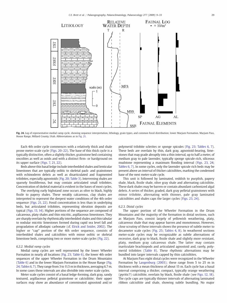
Fig. 24. Log of representative medial ramp cycle, showing sequence interpretation, lithology, grain types, and common fossil distribution; lower Marjum Formation. Marjum Pass,House Range, Millard County, Utah. Abbreviations as in Fig. 21.
29C.E. Brett et al. / Palaeogeography, Palaeoclimatology, Palaeoecology 277 (2009) 9–33
Each 4th order cycle commences with a relatively thick and shaleprone meter-scale cycle (Figs. 20–22). The base of this thick cycle is atypically distinctive, often a slightly thicker, grainstone bed containingoncolites as well as ooids and with a distinct firm- or hardground onits upper surface (Figs. 7, 21, 22).
Beds above this basal ledge include interbedded shales and lenticularlimestones that are typically oolitic to skeletal pack- and grainstoneswith echinoderm debris as well as disarticulated and fragmentedtrilobites, especially agnostoids (Fig. 20; Table 3). Intervening shales aresparsely fossiliferous, but may contain articulated small trilobites.Concentration of skeletal material is evident in the bases of most cycles.
The overlying early highstand zone occurs as olive to black, highlyfissile to papery shales. These weakly calcareous, clay shales areinterpreted to represent the deepest water conditions of the 4th ordersequence (Figs. 21, 22). Fossil concentration is less than in underlyingbeds, but articulated trilobites, representing obrution deposits aretypical (Figs. 13, 14). Higher portions of the sequence are composed ofcalcareous, platy shales and thin micritic, argillaceous limestones. Theyare sharply overlain by rhythmically interbedded shales and thin tabularto nodular micritic limestones formed during rapid sea level fall andprogradation of allodapic carbonate (cf. Elrick and Snider, 2002). Thehigher or “cap” portion of the 4th order sequence, consists ofinterbedded shales and calcisiltites with minor oolitic or skeletallimestone beds, comprising two or more meter-scale cycles (Fig. 22).
6.2.2. Medial ramp cyclesMedial ramp cycles are well represented by the lower Wheeler
Formation in nearly all locations (Fig. 23; Table 6), the lower 4th ordersequences of the upper Wheeler Formation in the Drum Mountains(Table 6) and in the lower Marjum Formation in the House Range (Fig.24; Tables 6, 7). They range from3 to11.5m in thickness, averaging6.7m.In some cases these intervals are also divisible into meter scale cycles.
Meter scale cycles consist of a basal ledge-forming, dark gray, sandytextured, argillaceous pelletal grainstone or calcisilitite; their uppersurfaces may show an abundance of comminuted agnostoid and/or
polymerid trilobite sclerites or sponge spicules (Fig. 23; Tables 6, 7).These beds are overlain by thin, dark gray, agnostoid-bearing, lime-stones thatmay grade abruptly into a thin interval, up to half a meter, ofmedium gray to pale lavender, typically sponge spicule-rich, siliceousmudstone representing a maximum flooding interval (Figs. 23, 24;Tables 6, 7). In some cycles, only the lavender spicule rich beds may bepresent above an interval of thicker calcisiltites, marking the condensedbase of the next meter-scale cycle.
This unit is followed by laminated, reddish to purplish, paperyshale, black, fissile shale, olive gray shale and alternating calcisiltite.These dark shales may be barren or contain abundant carbonized algaldebris. A series of thicker, graded, dark gray pelletal grainstones withminor trilobite, alternating with thinner, pale gray laminatedcalcisiltites and shales caps the larger cycles (Figs. 23, 24).
6.2.3. Distal cyclesThe upper portion of the Wheeler Formation in the Drum
Mountains and the majority of the formation in distal sections, suchas Marjum Pass, consist largely of yellowish weathering, platy,calcareous shale that may appear barren and monotonous. However,close scrutiny of these intervals shows the presence of subtle meter todecameter scale cycles (Fig. 25; Tables 4, 8). In weathered sectionsmeter-scale cycles may be recognizable as subtle alternations ofrecessive, dark gray to black, fissile shale and slightly more resistant,platy, medium gray calcareous shale. The latter may containinarticulate brachiopods and articulated agnostoid and, rarely, poly-merid trilobites (Table 8). These rhythmic alternations may bebundled into larger intervals capped by thin calcisiltites.
At Marjum Pass eight distal cycles were recognized in theWheelerFormation by Langenburg (2003); these range from 5 to 25 m inthickness with a mean thickness of about 15 m. Each cycle has a basalinterval comprising a thicker, compact, typically orange weathering(pyritic?) calcisiltite, overlain by black, fissile shale (see Figs. 12, 18).The cycle caps are typically thinner intervals of alternating laminatedribbon calcisiltite and shale, showing subtle bundling. No major
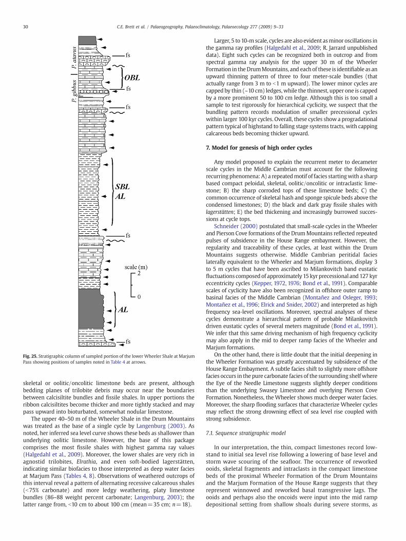
Fig. 25. Stratigraphic column of sampled portion of the lower Wheeler Shale at MarjumPass showing positions of samples noted in Table 4 at arrows.
30 C.E. Brett et al. / Palaeogeography, Palaeoclimatology, Palaeoecology 277 (2009) 9–33
skeletal or oolitic/oncolitic limestone beds are present, althoughbedding planes of trilobite debris may occur near the boundariesbetween calcisiltite bundles and fissile shales. In upper portions theribbon calcisiltites become thicker and more tightly stacked and maypass upward into bioturbated, somewhat nodular limestone.
The upper 40–50 m of the Wheeler Shale in the Drum Mountainswas treated as the base of a single cycle by Langenburg (2003). Asnoted, her inferred sea level curve shows these beds as shallower thanunderlying oolitic limestone. However, the base of this packagecomprises the most fissile shales with highest gamma ray values(Halgedahl et al., 2009). Moreover, the lower shales are very rich inagnostid trilobites, Elrathia, and even soft-bodied lagerstätten,indicating similar biofacies to those interpreted as deep water faciesat Marjum Pass (Tables 4, 8). Observations of weathered outcrops ofthis interval reveal a pattern of alternating recessive calcareous shales(b75% carbonate) and more ledgy weathering, platy limestonebundles (86–88 weight percent carbonate; Langenburg, 2003); thelatter range from, b10 cm to about 100 cm (mean=35 cm; n=18).
Larger, 5 to 10-m scale, cycles are also evident asminor oscillations inthe gamma ray profiles (Halgedahl et al., 2009; R. Jarrard unpublisheddata). Eight such cycles can be recognized both in outcrop and fromspectral gamma ray analysis for the upper 30 m of the WheelerFormation in theDrumMountains, and each of these is identifiable as anupward thinning pattern of three to four meter-scale bundles (thatactually range from 3 m to b1 m upward). The lower minor cycles arecapped by thin (~10 cm) ledges,while the thinnest, upper one is cappedby a more prominent 50 to 100 cm ledge. Although this is too small asample to test rigorously for hierarchical cyclicity, we suspect that thebundling pattern records modulation of smaller precessional cycleswithin larger 100 kyr cycles. Overall, these cycles show a progradationalpattern typical of highstand to falling stage systems tracts, with cappingcalcareous beds becoming thicker upward.
7. Model for genesis of high order cycles
Any model proposed to explain the recurrent meter to decameterscale cycles in the Middle Cambrian must account for the followingrecurringphenomena: A) a repeatedmotif of facies startingwith a sharpbased compact peloidal, skeletal, oolitic/oncolitic or intraclastic lime-stone; B) the sharp corroded tops of these limestone beds; C) thecommon occurrence of skeletal hash and sponge spicule beds above thecondensed limestones; D) the black and dark gray fissile shales withlagerstätten; E) the bed thickening and increasingly burrowed succes-sions at cycle tops.
Schneider (2000) postulated that small-scale cycles in the Wheelerand Pierson Cove formations of the DrumMountains reflected repeatedpulses of subsidence in the House Range embayment. However, theregularity and traceability of these cycles, at least within the DrumMountains suggests otherwise. Middle Cambrian peritidal facieslaterally equivalent to the Wheeler and Marjum formations, display 3to 5 m cycles that have been ascribed to Milankovitch band eustaticfluctuations composed of approximately 15 kyr precessional and127kyreccentricity cycles (Kepper, 1972, 1976; Bond et al., 1991). Comparablescales of cyclicity have also been recognized in offshore outer ramp tobasinal facies of the Middle Cambrian (Montañez and Osleger, 1993;Montañez et al., 1996; Elrick and Snider, 2002) and interpreted as highfrequency sea-level oscillations. Moreover, spectral analyses of thesecycles demonstrate a hierarchical pattern of probable Milankovitchdriven eustatic cycles of several meters magnitude (Bond et al., 1991).We infer that this same driving mechanism of high frequency cyclicitymay also apply in the mid to deeper ramp facies of the Wheeler andMarjum formations.
On the other hand, there is little doubt that the initial deepening inthe Wheeler Formation was greatly accentuated by subsidence of theHouse Range Embayment. A subtle facies shift to slightly more offshorefacies occurs in the pure carbonate facies of the surrounding shelfwherethe Eye of the Needle Limestone suggests slightly deeper conditionsthan the underlying Swasey Limestone and overlying Pierson CoveFormation. Nonetheless, the Wheeler shows much deeper water facies.Moreover, the sharp flooding surfaces that characterize Wheeler cyclesmay reflect the strong drowning effect of sea level rise coupled withstrong subsidence.
7.1. Sequence stratigraphic model
In our interpretation, the thin, compact limestones record low-stand to initial sea level rise following a lowering of base level andstorm wave scouring of the seafloor. The occurrence of reworkedooids, skeletal fragments and intraclasts in the compact limestonebeds of the proximal Wheeler Formation of the Drum Mountainsand the Marjum Formation of the House Range suggests that theyrepresent winnowed and reworked basal transgressive lags. Theooids and perhaps also the oncoids were input into the mid rampdepositional setting from shallow shoals during severe storms, as
31C.E. Brett et al. / Palaeogeography, Palaeoclimatology, Palaeoecology 277 (2009) 9–33
evidenced by discrete sharply bounded and vaguely graded bedsencased in shales, the presence of small gutter fills, rip-up clasts,and subtle hummocky cross stratification in some beds. In theabsence of other sediment input, as well as winnowing and bypassof fines, they accumulated to form lag sand blankets. In more distalsettings, sandy, pelletal limestones occur in analogous position tothe oolitic–oncolitic deposits. These sandy textured beds reflectwinnowing of allodapic carbonates during sea-level drops (Elrickand Snider, 2002), or initial transgression.
Oolitic shoals were preferentially established during early transgres-sive phases in shallow, but rather clear water conditions (see alsoMarkello and Read, 1981). Moreover, their abundant occurrencesuggests that the shallow shelf may have developed under semi-arid,slightly hypersaline conditions typical of the subtropical latitudes of theCambrian northern Laurentian platform.
The sharp, mineralized, runneled, and corrosion/erosion pockedupper surfaces of the limestones formed during periods of near totalsediment starvation associatedwithdrowningof the carbonateplatformandnear-shore sequestrationof siliciclastics in their sourceareas.Hence,rather than being sequence boundaries we infer that these representsurfaces of maximum sediment starvation associated with acceleratedbase level rise. These surfaces are sharply overlain by silts and clay shalesformed during deepening.
Maximum flooding zones are marked, in some cases, by condensedfossil fragmental and, in somewhat deeper water, by spicular siliceousmudstones. Under low sedimentation, but still oxic and relatively deepwater, conditions sponges appear to have thrived and their spicularskeletons accumulated to form a major component of the sediment.During ensuing early highstand the shallow carbonate platform hadretrograded up-ramp and major portions of the shelf may have beenflooded leading to minimal supply of detrital carbonate. At this point inthe cycle siliciclastics were input into the House Range Embayment andsurrounding shelf areas, in greater quantity, perhaps associated withincreased humidity and fluvial input. As noted above, there is noevidence that these siliciclastics were derived from the inner detritalbelt, at least not nearby. Either these muds were supplied from sourcesfurther north (present directions), as suggested by Elrick and Snider(2002), or from offshore terranes. Associated stratification of the watercolumnpromoteddevelopmentof dysoxic to anoxic facies on thedeeperramp and basin. Under such conditions, dark shales accumulated andoccasional burial events entombed organics and fossils. Relatively lowsedimentation enabled organic matter to be somewhat concentrated.The combination of anoxia (at least in the upper sediments) and pulsesof clay deposition favored soft-bodied organism preservation. Black,weakly calcareous shales are most pronounced in the 4th order cyclesthat occur in the late TST to early HST of the 3rd order sequences; forexample, in the lower third of the Wheeler Shale.
A greater carbonate content, relative to black to olive clay shales,occurs in calcareous dark shale facies in higher parts of sequences andsuggests a increased influx of detrital carbonate during highstandconditions. Decreasing accommodation in shelf environments favoredprogradation of the carbonate platform down ramp and allowed theinput of increasing amounts of fine silt-sand sized detrital carbonate, i.e.highstand shedding. This was also associated with deepening of theoxycline, such that low-oxygen adaptedorganisms, suchasElrathia, couldcolonize the seafloor. Dilution and instability of soft, rapidly depositedsubstrates, contributed to an upward decrease in the abundance ofbenthic organisms even as benthic oxygen conditions improved. Theincreasing supply of detrital siliciclastics and carbonate sediments alsomeant more frequent obrution deposits although these are not asrecognizable as in deeper parts of the cycle owing to dilution of organismremains.
Ultimately, seafloor deposition was interrupted by periods ofincreased erosion and bypass during falling stage to lowstand. Stormwave scouring produced sharply erosive surfaces typically with wellincised burrows marking temporary firmgrounds.
7.2. Comparison with other Paleozoic cycles and taphofacies
Cambrian cycles resemble in many ways those of later time such asthose of the Upper Ordovician Kope and Collingwood formations (Brettet al., 2003, 2006, 2008) and even, to a degree, Jurassic cycles in the BlueLias of Great Britain (Allison et al., in press). They are similar in thicknessand motif. In all cases there appears to be a coupling of a sea-levelfluctuationwith changing patterns of sedimentation, and a cyclic changein bottomwateroxygenation.However, Cambrian cycles differ verymuchin the composition of the condensed limestones (ooids, trilobite andsponge fragments, as opposed to brachiopod/mollusk shells, bryozoansand crinoid debris). There is also a greater presence of flat-pebbleintraclasts (see Sepkoski et al., 1991).
Perhaps most importantly, although all cycles may feature dark,organic-rich shales in the middle, early HST portions, only those of theEarly to Middle Cambrian feature much soft-bodied preservation in thisfacies and they show this with every cycle to varying degrees. A numberof hypotheses have attempted to explain the Cambrian lagerstättenwindow, including: an absence of dysoxic infauna (Allison and Briggs,1993; but see Aronson, 1992, 1993; and Pickerill, 1994; Orr et al., 2003),reactive clays (Butterfield, 1995; Orr et al., 1998), early carbonatecementing and porosity reduction (Gaines and Droser, 2005), andunusual chemical conditions that inhibited decay (Petrovich, 2001; butsee Powell, 2003 for counter arguments). Many of these mechanisms,however, should not be unique to the Cambrian.
This window may most closely correspond to the near absence ofburrowing organisms in dysoxic facies (Allison and Briggs, 1991, 1993;Orr et al., 2003; Powell et al., 2003). Middle Paleozoic and even LateOrdovician cycles showabundant small Chondrites and Planolites in darkorganic-rich facies. These are virtually lacking in the Cambrian cycleswehave examined, although small burrows were reported from bedsintercalated with barren layers yielding soft-bodied organisms (Gainesand Droser, 2005).We suggest that at this early time in development ofthe benthic ecosystem, larger infaunal organisms had not yet evolvedthe capacities to survive in low oxygen, hydrogen sulfide rich systems(see also Orr et al., 2003). As such, true exaerobic settings (sensu Savrdaand Bottjer, 1987), may have been muchmore widespread than in latertimes. Benthic epifaunal organisms survived in dysoxic environments inthe absence of a burrowing infauna. In contrast during Ordovician andlater geologic time small shallow burrowing organisms, such as nuculidbivalves and producers of Chondrites traces, became among the mosttolerant of lowbenthic oxygen levels and thusmayhavebeen among thefirst colonizers on dysoxic seafloors.
If burrowers were largely absent in dysoxic seafloors then littleoxygenwould have been introduced into the upper sediments and, onceburied, organism remains, even lightly sclerotized or soft partswould notbe disrupted. Hence, scenarios calling for major importation ofallochthonous remains may be unnecessary. The existence of a fluctuat-ing benthic oxygen regime enabled temporary seafloor colonization oftolerant benthic organisms (Gaines and Droser, 2003, 2005); this,coupled with episodic burial of more or less autochthonous epifaunasor nektobenthic formsmay partially account for soft bodied preservationin the more distal settings (cf. Orr et al., 2003; Powell et al., 2003).Nonetheless, we agree with Gaines and Droser (2005) that additionalmechanisms may also be at play in soft-bodied organism preservation,including deflocculation of clays and early diagenetic carbonate sealing.
In environments with increased oxygenation and some burrowing,excellentpreservationof articulated remainscould still takeplace, but theoccurrence of soft-bodied organisms would be reduced. Burial inrelatively impermeable fine clay rich sediment may have been a furtherfactor of key importance to the preservation of organism bodies near thepeak highstands as suggested by the coincidence of soft bodiedorganisms with high K-gamma ray “hot zones” (Halgedahl et al., 2009).The concatenation of rapid clay burial pulses with low oxygen, and anabsent dysoxic benthic infauna may in the end provide the keyingredients to explain the Early toMiddle Cambrian lagerstättenwindow.
32 C.E. Brett et al. / Palaeogeography, Palaeoclimatology, Palaeoecology 277 (2009) 9–33
8. Conclusions
A) Distinctive taphofacies, including soft-bodied lagerstätten,occur predictably in 10 m scale sequences in the MiddleCambrian Wheeler and Marjum Formations.
B) Compact oolitic and oncolitic and sandy peloidal carbonatebeds formed during initial transgressions following shallowingepisodes.Mounded cyanobacterial buildups are associatedwithperiods of rising sea level at the tops of some early TSTs;otherwise fossils are scarce and poorly preserved in the earlyTST.
C) Skeletal concentratins are represented by spicular and frag-mental trilobite hash beds and associated with the sediment-starved conditions of the later TST.
D) Conservation lagerstätten, featuring abundant algae and soft-bodied animals, occur primarily in the sparsely fossiliferousHST portions of cycles.
E) Obrution lagerstätten of articulated trilobites and eocrinoidswere preferentially preserved by episodic mud tempestites/turbidites on oxic seafloors of the HST to FSST.
F) The integration of sequence stratigraphy, sedimentology andtaphonomy is leading to integrated models that may not onlyexplain the distribution of various fossil groups and modes ofpreservation, but alsomay permit prediction of likely portions ofsedimentary cycles in which to prospect for extraordinarilypreserved biotas in Cambrian silicilcastic/carbonate successions.
Acknowledgements
We gratefully acknowledge the assistance and insights provided bySusanHalgedahl andRich Jarrard of theUniversityof Utah, Salt LakeCity.Rich kindly provided spectral gamma ray data for the T1–T2 cycle in theDrum Mountains. Discussions of various aspects of Cambrian strati-graphy, paleontology, and depositional environments with Loren Bab-cock, Robert Gaines, Allison (Pete) Palmer, and Ed Landing helped clarifyour ideas. Gordon Baird aided in early phases of fieldwork and MelissaMcMullen helped substantially in later field sampling. Initial field workwas funded by a NATO grant to PAA and CB.
References
Aitken, J.D., 1978. Revised models for depositional grand cycles, Cambrian of thesouthern Rocky Mountains. Canadian Bulletin of Petroleum Geology 26, 512–542.
Aitken, J.D., 1997. Stratigraphy of the Middle Cambrian platform succession, southernRocky Mountains. Geological Survey of Canada, Bulletin 396 322 pp.
Allison, P.A., 1986. Soft-bodied animals in the fossil record, the role of decay uponfragmentation during transport. Geology 14, 979–981.
Allison, P.A., 1988a. The decay and mineralization of proteinaceous macrofossils.Paleobiology 14, 139–154.
Allison, P.A., 1988b. Konservat -Lagerstätten: cause and classification. Paleobiology 14,331–344.
Allison, P.A., Briggs, D.E.G., 1991. Preservation of soft-tissues. In: Allison, P.A., Briggs, D.E.G.(Eds.), Taphonomy: releasing the data locked in the fossil record. Plenum Press, NewYork, pp. 26–71.
Allison, P.A., Briggs, D.E.G., 1993. Exceptional fossil record: distribution of soft tissuepreservation rough the Phanerozoic. Geology 21, 605–608.
Allison, P.A., Brett, C.E., 1995. In-situ benthos and paleo-oxygenation within the BurgessShale. Geology 26, 1079–1082.
Allison, P.A., Brett, C.E., Paul, C.R.C., Bilton, J., in press. Taphonomy of ammoniteKonzentrat Lagerstätten in the early Blue Lias Formation of Dorset, UK. Journal ofthe Geological Society of London.
Aronson, R.B., 1992. Decline of the Burgess Shale fauna: ecologic or taphonomicrestriction? Lethaia 25, 225–229.
Aronson, R.B., 1993. Burgess Shale-type biotas were not just burrowed away: reply.Lethaia 26, 185.
Babcock, L.E., Peng, S., Geyer, G., Shergold, J.H., 2005. Changing perspectives onCambrian chonostratigraphy and progress towards subdivision of the Cambriansystem. Geosciences Journal (Seoul) 9, 101–106.
Bergström, J.,1973. Organization, life, and systematics of trilobites. Fossils and Strata 2,1–69.Bond, G.C., Kominz, M.A., Grotzinger, J.P., 1988. Cambro-Ordovician eustasy: evidence
from geophysical modeling of subsidence in Cordilleran and Appalachian passivemargins. In: Kleispaahn, K.L., Paola, C. (Eds.), New Perspectives in Basin analysis.Springer Verlag, New York, pp. 129–160.
Bond, G.C., Kominz, M.A., Beavan, J., 1991. Evidence for orbital forcing of MiddleCambrian peritidal cycles: Wah Wah Range, south-central Utah. In: Franseen, E.K.,Watney, W.I., Kendall, C.G. St.C., Ross, W. (Eds.), Sedimentology Modeling:Computer Simulations and Methods for Improved Parameter Definition. KansasGeological Survey Bulletin, vol. 233, pp. 293–317.
Bowring, S.A., Erwin, D.H., 1998. A new look at evolutionary rates in deep time: unitingpaleontology and high-precision geochronology. GSA Today 8, 1–8.
Brady, M.J., Koepnick, R.B., 1979. AMiddle Cambrian platform-to-basin transition, HouseRange, west central Utah. Brigham Young University Geological Studies 26, 1–17.
Brett, C.E., 1995. Sequence stratigraphy, biostratigraphy, and taphonomy in shallowmarine environments. Palaios 10, 597–616.
Brett, C.E., 1998. Sequence stratigraphy, paleoecology, and evolution: biotic clues andresponses to sea-level fluctuations. Palaios 13, 241–262.
Brett, C.E., Algeo, T.J., McLaughlin, P.I., 2003. The use of event beds and sedimentarycycles in high-resolution stratigraphic correlation of lithologically repetitivesuccessions: the Upper Ordovician Kope Formation of Northern Kentucky andSouthern Ohio. In: Harries, P., Geary, D. (Eds.), High-Resolution StratigraphicApproaches to Paleobiology. Kluwer Academic/Plenum Press, Boston, pp. 315–351.
Brett, C.E., Allison, P.A., Tsujita, C.J., Soldani, D., Moffat, H., 2006. Sedimentology,taphonomy, and paleoecology of meter-scale cycles from the Upper Ordovician ofOntario. Palaios 21, 530–547.
Brett, C.E., Kirchner, B.T., Tsujita, C.J., Dattilo, B.F., 2008. Depositional dynamics recordedin mixed siliciclastic-carbonate marine successions: Insights from the UpperOrdovician Kope Formation of Ohio and Kentucky, USA. In: Pratt, B.R., Holmden, C.(Eds.), Dynamics of Epeiric Seas. Geological Association of Canada, Special Paper,48, 73–102.
Briggs, D.E.G., 2003. The role of decay and mineralization in the preservation of soft-bodied fossils. Annual Review of Earth and Planetary Sciences 31, 275–301.
Briggs, D.E.G., Robison, R.A., 1984. Exceptionally Preserved Non-trilobite Arthropodsand Anomalocaris from the Middle Cambrian of Utah. University of KansasPaleontological Contributions, no. 111. University of Kansas PaleontologicalInstitute, Lawrence.
Briggs, D.E.G., Lieberman, B.S., Halgedahl, S.L., Jarrard, R.D., 2005. A newmetazoan fromthe Middle Cambrian of Utah and the nature of the Vetulicolia. Palaeontology 48,681–686.
Bright, R.C., 1959. A paleoecologic and biometric study of the Middle Cambrian trilobiteElrathia kingi (Meek) [Utah]. Journal of Paleontology 33, 83–98.
Butterfield, N.J., 1990. Organic preservation of non-mineralizing organisms and thetaphonomy of the Burgess Shale. Paleobiology 16, 272–286.
Butterfield, N.J., 1995. Secular distribution of Burgess Shale-type preservation. Lethaia28, 1–13.
Caron, J.B., Jackson, D.A., 2006. Taphonomy of the greater Phyllopod Bed community,Burgess Shale. Palaios 21, 451–465.
Coe, A.L. (Ed.), 2003. The Sedimentary Record of Sea-level Change. CambridgeUniversity Press, Cambridge, UK. 288 pp.
Conway Morris, S., Robison, R.A., 1986. Middle Cambrian priapulids and other soft-bodied fossils from Utah and Spain. University of Kansas PaleontologicalContributions. Paper 117, 1–22.
Conway Morris, S., Robison, R.A., 1988. More soft-bodied animals and algae from theMiddle Cambrian of Utah and British Columbia. University of Kansas Paleontolo-gical Contributions. Paper 122, 1–48.
Crittenden Jr., M.D., Straczek, J.A., Roberts, R.J., 1961. Manganese deposits in the DrumMountains, Millard and Millard County, Utah. United States Geological SurveyBulletin 1082-H, 493–544.
Dommer, M.L., 1980. The geology of the DrumMountains, Millard and Millard Counties,Utah. Brigham Young University Geology Studies 27 (3), 55–72.
Droser, M.L., Bottjer, D.J., 1988. Trends in depth and extent of bioturbationin carbonatecarbonate marine environments. Geology 16, 233–236.
Elrick, M., Snider, A.C., 2002. Deep-water stratigraphic cyclicity and carbonate mudmound development in the Middle Cambrian Marjum Formation, House Range,Utah, USA. Sedimentology 49, 1021–1047.
Gaines, R.R., Droser, M.I., 2003. Paleoecology of the familiar trilobite Elrathia kingii: anearly exaerobic zone inhabitant. Geology 31, 941–944.
Gaines, R.R., Droser, M.L., 2005. New approaches to understanding the mechanics ofBurgess Shale-type deposits: from the micron scale to the global picture.Sedimentary Record 3, 4–8.
Gaines, R.R., Kennedy, M.J., Droser, M.L., 2005. A new hypothesis for organicpreservation of Burgess Shale taxa in the Middle Cambrian Wheeler Formation,House Range, Utah. Palaeogeography, Palaeoclimatology, Palaeoecology 220,193–205.
Gradstein, F.M., Ogg, J.G., Smith, A.G., et al., 2004. A Geologic Time Scale 2004.Geological Survey of Canada Report 86, Ottawa, Ontario. 1 pp.
Grannis, J.L. 1982, Sedimentology of the Wheeler Formation, Drum Mountains, Utah.Unpublished MS Thesis, University of Kansas, Lawrence, Kansas.
Halgedahl, S., Jarard, R., Brett, C.E., Allison, P.A., 2009. Geophysical and geologicalsignatures of relative sea level change in the upper Wheeler Formation, DrumMountains, West-central Utah: a perspective into exceptional preservation offossils. Palaeogeography, Palaeoclimatology, Palaeoecology 277, 34–56.
Hintze, L.F., Robison, R.A., 1975. Middle Cambrian stratigraphy of the House, Wah Wah,and adjacent ranges in western Utah. Geological Society of America 86, 881–891.
Hintze, L.F., Davis, F.D., 2002. Geologic map of Delta Quadrangle, Lynndyl Quadrangle,Millard, Millard, Sanpete, and Sevier Counties, Utah, UGS Map 184 Utah GeologicalSurvey, Utah Department of Natural Resources.
Kepper, J.C., 1972. Paleoenvironmental patterns in the Middle to lower Upper Cambrianinterval in eastern Great Basin. American Association of Petroleum GeologistsBulletin 58, 503–527.
33C.E. Brett et al. / Palaeogeography, Palaeoclimatology, Palaeoecology 277 (2009) 9–33
Kepper, J.C., 1976. Stratigraphic relationships and depositional facies in a portion of theMiddle Cambrian of the Basin and Range. Brigham Young University GeologicalStudies 23, 75–91.
Landing, E., 2007. Ediacaran–Ordovician of east Laurentia geologic setting and controlson deposition along the New York Promontory. In: Landing, E. (Ed.), Ediacaran–Ordovician of east Laurentia. S. W. Ford Memorial Volume. New York State MuseumBulletin, vol. 510, pp. 5–24. 93 pp., 30 figs.
Langenburg, E.S., 2003. The Middle Cambrian Wheeler Formation: sequencestratigraphy and geochemistry across a ramp-to-basin transition. Utah StateUniversity, Logan, Utah, unpub. M.S. thesis, (120 pp).
Markello, J.R., Read, J.F., 1981. Carbonate ramp-to-deeper shale shelf transitions of anUpper Cambrian intrashelf basin: Nolichucky Formation southwest VirginiaAppalachians. Sedimentology 28, 573–597.
Montañez, L.P., Osleger, D.A., 1993. Parasequence stacking patterns, third orderaccommodation events and sequence stratigraphy of Middle to Upper Cambbrianplatform carbonates, Bonanza King Formation, southern Great Basin. In: Loucks, B.,Sarg, J.F. (Eds.), American Association of Petroleum Geologists Memoir, vol. 57, pp.305–326.
Montañez, L.P., Banner, J.L., Osleger, D.A., Borg, L.E., Bosserman, P.J., 1996. Integrated Srisotope stratigraphy and relative sea-level history in Middle Cambrian platformcarbonates. Geology 24, 917–920.
Orr, P.J., Briggs, D.E.G., Kearns, S.L., 1998. Cambrian Burgess Shale animals replicated inclay minerals. Science 281, 1173–1175.
Orr, P.J., Benton, M.J., Briggs, D.E.G., 2003. Post-Cambrian closure of the deep-waterslope-basin taphonomic window. Geology 31, 769–772.
Oschmann, W., 1991. Anaerobic-poikilaerobic-aerobic: a new facies zonation formodern and ancient redox facies. In: Einsele, G., Ricken, W., Seilacher, A. (Eds.),Cycles and Events in Statigraphy. Springer-Verlag, Berlin, pp. 565–571.
Palmer, A.R., 1960. Some aspects of the Upper Cambrian stratigraphy of White PineCounty, Nevada, and vicinity. Intermountain Association of Petroleum Geologists.Eleventh Annual Field Conference, pp. 53–58.
Palmer, A.R., 1971. The Cambrian of the Great basin and adjacent areas, western UnitedStates. In: Holland, C.H. (Ed.), Cambrian of the NewWorld. Wiley Interscience, NewYork, pp. 1–78.
Petrovich, R., 2001. Mechanisms of fossilization of the soft-bodied and lightly armoredfaunas of the Burgess shale and of some other classical localities. American Journalof Science 301, 683–726.
Pickerill, R.K., 1994. Exceptional fossil record: distribution of soft-tissue preservationthrough the Phanerozoic: discussion. Geology 22, 183–184.
Powell, W.G., 2003. Greenschist-facies metamorphism of the Burgess Shale and itsimplications for models of fossil formation and preservation. Canadian Journal ofEarth Sciences 40, 13–25.
Powell, W.G., Johnston, P.A., Collom, C.J., 2003. Geochemical evidence for oxygenatedbottom waters during deposition of fossiliferous strata of the Burgess ShaleFormation. Palaeogeography, Palaeoclimatology, Palaeoecology 201, 249–268.
Randolph, R.L., 1973. Paleontology of the Swasey Limestone, Drum Mountains, west-central Utah. Unpublished MS Thesis, University of Utah, Salt Lake City, 73 pp.
Rees, M., 1986. A fault-controlled trough through a carbonate platform: the MiddleCambrian House Range embayment. Geological Society of America Bulletin 97,1057–1069.
Rees, M., Robison, R.A., 1989. Days 5 and 6: Cambrian stratigraphy and paleoecology ofthe central House Range and Drum Mountains, Utah. In: Taylor, M.E. (Ed.),Cambrian and Early Ordovician Stratigraphy and Paleontology of the Basin andRange Province. IGC Field Trip Guidebook T125. American Geophysical Union,Washington, DC, pp. 59–72.
Robison, R.A., 1964. Upper Middle Cambrian stratigraphy of western Utah. GeologicalSociety of America Bulletin 75, 995–1010.
Robison, R.A., 1976. Middle Cambrian biostratigraphy of the Great Basin. Brigham YoungUniversity Studies in Geology 23, 93–109.
Robison, R.A., 1982. Some Middle Cambrian agnostoids from the from western NorthAmerica. Journal of Paleontology 56, 132–160.
Robison, R.A., 1984a. New occurrences of the unusual trilobite Naraoia from theCambrian of Idaho and Utah. University of Kansas Paleontological Contributions.Paper 112, 1–8.
Robison, R.A., 1984b. Cambrian Agnostida from North America and Greenland: Part 1.Ptychagnostidae. University of Kansas Paleontological Contributions 109, 1–59.
Robison, R.A., 1991. Middle Cambrian biotic diversity: examples from four Utah Lager-stätten. In: A.M. Simonetta, M., Conway Morris, S. (Eds.), The Early Evolution ofMetazoa and the Significance of Problematic Taxa. Cambridge University Press,Cambridge, pp. 77–98.
Rogers, J.C., 1984. Depositional environments and paleoecology of two quarry sites inthe Middle Cambrian Marjum and Wheeler Formations, House Range, Utah.Brigham Young University Geology Studies 31, 97–115.
Savrda, C.E., Bottjer, D.J., 1987. The exarobic zone, a new oxygen-deficient marinebiofacies. Nature 327, 54–56.
Schneider, L.P., 2000. The sequence stratigraphy of the Middle Cambrian WheelerFormation in the Drum Mountains of west central Utah. Utah State University,Logan, Utah, unpub. M.S. thesis, 82 pp.
Scotese, C.R., 1997. PALEOMAP Paleogeographic Atlas. PALEOMAP Progress Report 20.Department of Geology, University of Texas, Arlington.
Seilacher, A., 2001. Concretion morphologies reflecting diagenetic and epigeneticpathways. Sedimentary Geology 243, 41–57.
Seilacher, A., Reif, W.E., Westphal, F., 1986. Sedimentological, ecological and temporalpatterns of fossil Lagerstätten. Philosophical Transactions of the Royal Society ofLondon B311, 5–23.
Sepkoski Jr., J.J., Bambach, R.K., Droser, M.L., 1991. Secular changes in Phanerozoic eventbedding and the biological overprint. In: Einsele, G., Ricken, W., Seilacher, A. (Eds.),Cycles and Events in Statigraphy. Springer-Verlag, Berlin, pp. 298–312.
Sundberg, F.A., 1994. Corynexochida and Ptychopariida (Trilobita, Arthropoda) of theEhmaniella Biozone, Middle Cambrian), Utah and Nevada. Natural History Museumof Los Angeles County, Contributions in Science 446, 1–137.
Vorwald, 1983. Paleontology and paleoecology of the upper Wheeler Formation (lateMiddle Cambrian), Drum Mountains, west-central Utah. Unpublished MS Thesis,University of Kansas, 117 pp.
Walcott, C.D., 1908. Cambrian geology and paleontology, pt.1. Nomenclature for someCambrian Cordilleran formations. Smithsonian Miscellaneous Collections 53, 1–12.
Westfield, I.T., Liddell, W.D., Brett, C.E., 2005. Cambrian microbial communities along abathymetric gradient. Geological Society of America Abstracts with Programs 37(7), 340.
Vail, P.R., Audemard, F., Bowman, S.A., Eisner, P.N., Pérèz-Cruz, C., 1991. The stratigraphicsignatures of tectonics, eustasy and sedimentation: an overview. In: Einsele, G.,Ricken, W., Seilacher, A. (Eds.), Cycles and Events in Stratigraphy. Springer, NewYork, pp. 617–659.
Van Wagoner, J.C., Mitchum, K., Campion, K.M., Rahmanian, V.D., 1990. Siliciclasticsequence stratigraphy in well logs, cores, and outcrops. American Association ofPetroleum Geologists Methods in Exploration Series, No. 7, Tulsa. 55 pp.
Young, G.C., Laurie, R.R., 1996. An Australian Phanerozoic Timescale. Oxford UniversityPress, Melbourne, Australia.