sentinel-2 mission requirements documentmdisney/teaching/teachingnew/3051/pprs_3/... ·...
TRANSCRIPT

a
GMES_Sentinel-2_MRD_issue_2.1_mdru_08032010
D O C U M E N T
document title/ titre du document
prepared by/préparé par ESA Sentinel-2 Team
reference/réference EOP-SM/1163/MR-dr
issue/édition 2
revision/révision 1
date of issue/date d’édition 8/03/2010
status/état Final
Document type/type de document MRD
Distribution/distribution ESA


GMES Sentinel-2 Mission Requirements Document issue 2 revision 1 - 8/03/2010
EOP-SM/1163/MR-dr page iii of iv
C H A N G E L O G
reason for change /raison du changement issue/issue revision/revision date/date
Initial Issue Updated version Revised version
1 2 2
0 0 1
11/11/2004 30/01/2007 8/03/2010
C H A N G E R E C O R D
Issue: 2 Revision: 1
reason for change/raison du changement page(s)/page(s) paragraph(s)/paragraph(s)
Re-structured following release of QMS-PR-MMAN-2050-PM Due to availability from other GMES contributing missiondata, the potential (non systematic) acquisition of given areas for Emergency Services is not required. MR-S2-08 has been removed; MR-S2-11 has been modified accordingly. Introduction of IR instrument has been removed. Reference document RD-28 has been removed. REDD has been introduced. Geographical coverage changed from 83 N to 84 N Table 4 band 10 Lmax updated with new reference levels for observation mode.
all 16 (version 2.0) 24 1 (version 2.0) 29 (in version 2.0) 11 25, 37 28
all Section 3.5 deleted(version 2.0) Section 5.7 changed 5 (version 2.0) Section 5.8, Table 9

GMES Sentinel-2 Mission Requirements Document issue 2 revision 1 - 8/03/2010
EOP-SM/1163/MR-dr page iv of iv
TABLE OF CONTENTS
1 INTRODUCTION ....................................................................................................1 1.1 Scope of the document.....................................................................................................................................1 1.2 Organisation of the Sentinel-2 MRD ...............................................................................................................1 1.3 Applicable and Reference Documents.............................................................................................................1
1.3.1 Applicable Documents (AD).......................................................................................................................1 1.3.2 Reference Documents (RD) ........................................................................................................................1
1.4 Acronyms and abbreviations ...........................................................................................................................3 1.5 Definitions .......................................................................................................................................................5
2 BACKGROUND AND SCIENTIFIC JUSTIFICATION......................................................6
3 USER INFORMATION REQUIREMENTS........................................................................7 3.1 Introduction......................................................................................................................................................7 3.2 User Information Services Overview...............................................................................................................8
3.2.1 Geoland2 .....................................................................................................................................................8 3.2.2 SAFER.......................................................................................................................................................12 3.2.3 G-MOSAIC ...............................................................................................................................................16 3.2.4 GMES fast track SERvices........................................................................................................................18
3.3 Summary of User Information Requirements................................................................................................19
4 MISSION OBJECTIVES.................................................................................................21
5 MISSION REQUIREMENTS AND ELEMENTS .............................................................22 5.1 Introduction....................................................................................................................................................22 5.2 Continuity, Performance and Availability .....................................................................................................22 5.3 Revisit ............................................................................................................................................................23 5.4 Coverage ........................................................................................................................................................23 5.5 Time of Observation ......................................................................................................................................24 5.6 Instantaneous Coverage .................................................................................................................................24 5.7 Timeliness......................................................................................................................................................24 5.8 Geographical Coverage..................................................................................................................................24 5.9 Spectral Sampling..........................................................................................................................................25 5.10 Radiometric Requirements ............................................................................................................................28 5.11 Quantization resolution..................................................................................................................................29 5.12 Spatial Resolution..........................................................................................................................................29 5.13 Geo-location Requirements ...........................................................................................................................30 5.14 Service Data Products....................................................................................................................................31
6 SYSTEM CONCEPT OVERVIEW...........................................................................32 6.1 Mission Overview..........................................................................................................................................32 6.2 Space Segment...............................................................................................................................................33 6.3 Ground Segment and Data Processing...........................................................................................................34 6.4 Operation and Utilisation Concept ................................................................................................................35 6.5 Performance Aspects .....................................................................................................................................36
7 SUMMARY AND CONCLUSIONS.................................................................................36
8 ANNEX A........................................................................................................................38
GMES Sentinel-2 Mission Requirements Document issue 2 revision 1 - 30/01/2007
EOP-SM/1163/MR-dr page 1 of 38
1 0BINTRODUCTION
1.1 8BScope of the document This document is the Sentinel-2 Mission Requirements Document (MRD), the top-level document describing the mission requirements for the Global Monitoring for Environment and Security (GMES) Sentinel-2 mission based on the underlying objectives. The MRD outlines the identified user requirements and transforms these requirements into traceable mission requirements specifying the observational needs and quantitative requirements in terms of geographical coverage, revisit time, spectral, radiometric and geometric performance. The MRD is used for subsequent derivation of the system requirements, specifying in detail the system requirements for all engineering aspects implementing the mission. System requirements are specified in the System Requirements Document (SRD). The Sentinel-2 MRD is managed by the Sentinel-2 mission scientist according to the procedure set out in [AD-1].
1.2 9BOrganisation of the Sentinel-2 MRD In accordance with [AD-1] the Sentinel-2 MRD is organised into the following sections:
1. Introduction (this section) 2. Background and Scientific Justification 3. User Information Requirements 4. Mission Objectives 5. Mission Requirements and Elements 6. System Concept Overview 7. Sentinel-2 traceability matrix to GMES requirements
1.3 10BApplicable and Reference Documents
1.3.1 35BAPPLICABLE DOCUMENTS (AD)
Code Value AD-1 Procedure for Earth Observation Mission Requirements Definition and Management, QMS-
PR-MMAN-2050-EOP
1.3.2 36BREFERENCE DOCUMENTS (RD)
Code Value RD-1 ESA/PB-EO(2004)76, rev.1 RD-2 Martimort et al.: Sentinel-2 – The Optical High-Resolution Mission for GMES Operational
Services, ESA Bulletin 131, August 2007 RD-3 http://www.gmes.info/pages-principales/projects/ RD-4 GMES Fast Track Land Monitoring Core Service (LMCS). Executive summary of the

GMES Sentinel-2 Mission Requirements Document issue 2 revision 1 - 30/01/2007
EOP-SM/1163/MR-dr page 2 of 38
Strategic Implementation Plan. By Prof. Dietmar Gruenreich for the Land Monitoring Core Service Implementation Group. GAC/2007/4.
RD-5 GMES Fast Track Emergency Response Core Service (ERCS). Executive summary of the Strategic Implementation Plan. Prof. Bernardo De Bernardinis for the Emergency Response Core Service Implementation Group. GAC/2007/3.
RD-6 http://www.gmes.info/pages-principales/projects/land-projects/geoland2/ RD-7 GSE Land website: http://www.gmes-gseland.info RD-8 GSE Forest Monitoring website: HUhttp://www.gmes-forest.infoU RD-9 KYOTO INV Website: http://kyoto-inv.pisa.intecs.it/ RD-10 Geoland requirements on EO Space & Ground Segment, issued by the Geoland Executive
Board Members, 10/02/2006, http://www.gmes-geoland.info. RD-11 http://www.gmes.info/pages-principales/projects/emergency-projects/safer/ RD-12 GSE RISK-EOS website: HUhttp://www.risk-eos.comU RD-13 GSE RESPOND website: http://www.respond-int.org/ RD-14 http://www.gmes.info/pages-principales/projects/security-projects/ RD-15 GSE GMFS website: http://www.gmfs.info/ RD-16 GLC2000 website: http://www-gvm.jrc.it/glc2000/ RD-17 CORINE website at the EEA (European Environment Agency):
http://dataservice.eea.europa.eu/dataservice/ RD-18 ESA GMES Web Site http://earth.esa.int/gmes/ RD-19 GMES Products & Services supporting the Implementation of European Directives and
International Policies & Conventions linked to “land cover & Vegetation”, http://www.gmes-geoland.info/project.php.
RD-20 Data User Element Web Site: Hhttp://dup.esrin.esa.it/H. RD-21 GMES Sentinel-2 Spectral Bands Fine-tuning Study, ESA Technical Note S2-TN-ESA-MS-
19 RD-22 Envisat/MERIS Web description: http://envisat.esa.int/instruments/meris/ RD-23 Root R., Zarco-Tejada P., Pinilla C., Ustin S., Kokaly R., Anderson G., and Hager S.
Identification, Classification, and Mapping of Invasive Leaf Spurge Using Hyperion, AVIRIS, and CASI. EO1 Validation Report.
RD-24 MODIS ATBD Atmospheric Correction Algorithm Spectral Reflectances. ATBD-MOD-08. Version 4.0 04/30/1999.
RD-25 MODIS Web Site: http://modis.gsfc.nasa.gov/ RD-26 Landsat Data Continuity Mission (LDCM) Web Site: Hhttp://ldcm.nasa.gov RD-27 VIIRS Web description: HUhttp://www.ipo.noaa.gov/Technology/viirs_summary.htmlU RD-28 Drake, N. A., Mackin, S., Settle, J. J., 1999. Mapping Vegetation, Soils, and Geology in
Semiarid Shrublands Using Spectral Matching and Mixture Modeling of SWIR AVIRIS Imagery. Remote Sensing of Environment, Volume 68, Issue 1, April 1999, Pages 12-25.
RD-29 Mougenot et al., 2000. Applications of VEGETATION data to resource management in arid and semi-arid rangelands. SPOT-VEGETATION Workshop.
RD-30 Zarco-Tejada P. J., Miller, J.R., 1999. Land cover mapping at BOREAS using red edge spectral parameters from CASI imagery. Journal of Geophysical Research, Vol. 104, no. D22, pp. 27,921-27,933.
RD-31 Dash J. & Curran P.J. (2004) Evaluation of the MERIS Terrestrial Chlorophyll Index. Evaluation. ESA Envisat Workshop, Salzburg (Austria), ESA document SP-572.
RD-32 Rast, M., U. Del Bello et al. (2001) SPECTRA – Surface Processes and Ecosystem Changes Through Response Analysis, ESA SP-1257(5), 126 pp
RD-33 Toutin, T. (2004). Review Paper: Gemometric Processing of Remote Sensing Images:

GMES Sentinel-2 Mission Requirements Document issue 2 revision 1 - 30/01/2007
EOP-SM/1163/MR-dr page 3 of 38
Models, Algorithms and Methods, International Journal of Remote Sensing, vol. 25, no. 10, pp 1893-1924(32)
RD-34 Gobron, N., B. Pinty, M. Verstraete, Y. Govaerts, 1999. The MERIS Global Vegetation Index (MGVI): description and preliminary application. International Journal of Remote Sensing. 20 (9). 1917-1927.
RD-35 Data Access Portfolio Requirement Document (DAP/R), GMES-PMAN-EOPG-RD-08-0002, Version 1.1, 15/03/2009
RD-36 Data Access Portfolio Document, i1 r0 : HUhttp://gmesdata.esa.int/web/gsc/dap_documentU
1.4 11BAcronyms and abbreviations Acronym Meaning AD Applicable Document ALI Advanced Land Imager ALOS Advanced Land Observing Satellite AVHRR Advanced Very High Resolution Radiometer AVIRIS Airborne Visible / Infrared Imaging Spectrometer BS Burn Scars Cab Leaf Chlorophyll Content CAP Common Agriculture Policy CASI Compact Airborne Spectrographic Imager CD Crown Density CDM Change Detection Map CDS Coordinated Data Access System CEOS Committee on Earth Observation Satellites Cw Leaf water content CNES Centre National d’Etudes Spatiales CORINE Coordination of Information on the Environment CFSAM Crop and Food Supply Assessment Mission CHRIS-PROBA
Compact High Resolution Imaging Spectrometer – Project for Onboard Autonomy
CMOS Complementary Metal Oxide Semiconductor DAG Data Access Gateway DAIL Data Access & Integration Layer DG Directorate General DUE Data User Element DUP Dater User Programme EC European Commission EEA European Environmental Agency EO Earth Observation ERCS Emergency Response Core Service ESA European Space Agency ESOC European Space Operations Centre EU European Union FA Forest Age FAO Food and Agriculture Organization FAPAR Fraction of Absorbed Photosynthetically Active Radiation

GMES Sentinel-2 Mission Requirements Document issue 2 revision 1 - 30/01/2007
EOP-SM/1163/MR-dr page 4 of 38
FL Fuel Load FM Forest Monitoring FNPAV Fraction of Non-Photosynthetically Active Vegetation FOS Flight Operations Segment FRM Flood Monitoring FTS Fast Track Service FVC Fraction of Vegetation Cover GCM GMES Contributing Missions GCP Ground Control Point GCS GMES Core Service GI Geographic Information GLC Generic Land Cover GMES Global Monitoring for Environment and Security GMFS Global Monitoring for Food Security GSC GMES Space Component GSCDA GMES Space Component Data Access GSE GMES Service Element GSS GMES Service Segment GUS GMES Urban Services HRV High Resolution Visible HyMap Hyperspectral Mapper IDP Internally Displaced People INSCRIT Information Service in Response to Crisis ISP Instrument Source Packets Kompsat-II Korea Multi-Purpose Satellite LAI Leaf Area Index LCM Land Cover Map LDCM Landsat Data Continuity Mission LMCS Land Monitoring Core Service LUT Look-up Table MERIS Medium Resolution Imaging Spectrometer MMU Minimum Mapping Unit MODIS Moderate Resolution Imaging Spectrometer MRD Mission Requirements Document MGVI MERIS Global Vegetation Index MMUS Multi-Mission User-Services MSI MultiSpectral Instrument MTCI MERIS Terrestrial Chlorophyll Index NGO Non-Governmental Organizations NIR Near Infra Red NRT Near Real Time OCHA UN Office for Coordination of Humanitarian Affairs OZA Observation Zenith Angle PDI Product Data Item RD Reference Document REDD Reduced Emission from Deforestation and Degradation in Developing Countries RMS Root Mean Square S2 Sentinel-2
GMES Sentinel-2 Mission Requirements Document issue 2 revision 1 - 30/01/2007
EOP-SM/1163/MR-dr page 5 of 38
SA Surface Albedo SAGE Service for the Provision of Advanced Geo-Information on Environmental Pressure and
State SC Snow Cover SFRI Structural Fire Risk Index SNR Signal to Noise Ratio SPOT Satellite Pour l’Observation de la Terre SRD System Requirements Review STS Spatio-Temporal Synthesis SWIR Short Wave Infra Red TOA Top-Of-Atmosphere TM Thematic Mapper TPM Third Party Missions UN United Nations UNCBD UN Convention on Biological Diversity UNCCD UN Convention to Combat Desertification UNDPKO UN Department of Peace Keeping Operations UNECE UN Economic Commission for Europe UNFCCC UN Framework Convention on Climate Change UNHCR UN High Commissioner for Refugees VENUS Vegetation and Environment monitoring on a New Micro-Satellite VIIRS Visible Infrared Imager Radiometer Suite VNIR Visible to Near Infra Red VPI Vegetation Productivity Indicator WFP World Food Programme
1.5 12BDefinitions UEmergency Unpredictable event that shall be sensed by the satellite and distributed as soon as possible to the user (e.g. civil protection). UGoal The term “goal” denotes a non-mandatory requirement, the implementation of which shall be studied to allow for an assessment of the system impacts. The implementation or not of the goal requirements will be decided by the Agency after proper analysis of the implications. UProduct Level 0 Raw data after restoration of the chronological data sequence for the instrument(s) operating in observation mode, at full space/time resolution with all supplementary information to be used in subsequent processing (e.g. orbital data, health, time conversion, etc.) appended. Level 0 data are time-tagged. The precision and accuracy of the time-tag shall be such that the measurement data may be localized to accuracy compatible with the users’ requirements. UProduct Level 1A Level 0 data with corresponding radiometric, spectral and geometric (i.e. Earth location) correction and calibration computed and appended, but not applied.

GMES Sentinel-2 Mission Requirements Document issue 2 revision 1 - 30/01/2007
EOP-SM/1163/MR-dr page 6 of 38
UProduct Level 1B Level 1a data not re-sampled, quality-controlled and radiometrically calibrated, spectrally characterised, geometrically characterised, annotated with satellite position and pointing, landmarks and preliminary pixel classification (e.g. land/water/cloud mask). The Level 1b product consists of Top of Atmosphere (TOA) radiance (W.m-2.sr-1. m-1). UProduct Level 1C Level 1b data orthorectified, re-sampled to a specified grid. Image re-sampling shall be performed using a selectable re-sampling method including at least bi-cubic convolution interpolation and nearest neighbour (see also Chapter 6.4). UProduct Level 2A Earth located pixel values converted to ground surface reflectance, i.e. after atmospheric corrections. UProduct Level 2b Earth located pixel values converted to geophysical variables (land cover or geo-biophysical variable maps). UProduct Level 3 Spatially and/or temporally re-sampled biophysical variables and land cover maps. USystematic Acquisition Continuous and uniform operation of the instrumentation to allow carpet like uninterrupted acquisition. UThreshold A requirement that is considered compulsory for the mission.
2 1BBACKGROUND AND SCIENTIFIC JUSTIFICATION GMES is a joint initiative of the European Commission (EC) and the European Space Agency (ESA), designed to establish a European capacity for the provision and use of operational monitoring information for environment and security applications. This Capacity is seen to be composed of three modules, which together constitute the functional GMES ‘system’:
The production and dissemination of information in support of EU (European Union) policies for Environment and Security;
The mechanisms needed to ensure a permanent dialogue between all stakeholders and in particular between providers and users;
The legal, financial, organisational and institutional frame to ensure the functioning of the system and its evolution.
Many elements of the modules already exist but have been conceived, designed and managed in isolation, thus limiting interoperability and production of relevant information. The coherence, efficiency and sustainability of a shared information system for Europe will be the added value of GMES. Developing

GMES Sentinel-2 Mission Requirements Document issue 2 revision 1 - 30/01/2007
EOP-SM/1163/MR-dr page 7 of 38
compatibility between the existing elements, establishing cooperation between the organisations and filling the gaps where necessary will achieve this. ESA’s role in GMES is to provide the definition and the development of the space-related system elements. GMES Sentinel-2 mission provides continuity to services of relying on multi-spectral high-resolution optical observations over global terrestrial surfaces [RD-1, RD-2]. Sentinel-2 will capitalise on the technology and the vast experience acquired in Europe and the US with systems such as the SPOT (Satellite Pour l’Observation de la Terre) and Landsat families over the past decades. Sentinel-2 will directly contribute to the Land Monitoring, Emergency Response, and Security. The land surface requirements for low spatial resolution and high revisit optical imaging will be covered by the Sentinel-3 mission. The Sentinel-3 mission will provide continuity to Medium Resolution Imaging Spectrometer (MERIS) , SPOT4-VEGETATION, and Advanced Very High Resolution Radiometer (AVHRR) observations.
3 2BUSER INFORMATION REQUIREMENTS
3.1 13BIntroduction User requirements and their definition are evolving with time; they are formulated in terms of information needs and have to be translated into observational requirements. Matching user requirements and observational capabilities requires the establishment of an interface between system designers and data providers with the user community. As it is not feasible to satisfy all user requirements an order of priorities will have to be established. The choice of initial services to establish the foundations of GMES, is based on three main criteria:
availability and maturity reliability and usefulness long-term sustainability.
These criteria lead to the following choice of priority services for which the Sentinel-2 mission is tailored taking also account of potential new services and service evolutions over time:
Natural hazards management (e.g. floods, forest fires, volcano eruptions, subsidence and landslides) European land use / land cover state and changes (including soil sealing), Forest Monitoring, Food security – Early warning systems, Global change issues, Humanitarian Aid.
The “Forum GMES 2008” held in Lille, France, in September 2008 marked the launch of the first GMES services in pre-operational mode [RD-3]. At that stage, the provision of these first services is ensured through R&D projects funded under the 7th Framework Programme of the European Union, namely (1) Land Monitoring (Geoland2), (2) Ocean Monitoring (MyOcean), (3) Atmosphere Monitoring (MACC), (4) Emergency Response (SAFER) and (5) Security (G-MOSAIC).

GMES Sentinel-2 Mission Requirements Document issue 2 revision 1 - 30/01/2007
EOP-SM/1163/MR-dr page 8 of 38
3.2 14BUser Information Services Overview In 2008, GMES pre-operational services were launched, with the objective to move into the operational phase in 2011. The definition and setting up of these five pre-operational services have been assigned to projects financed through the Research and Development Framework Programmes of the European Union. The aim of this sub-chapter is to briefly describe the different services that have been identified and considered in the definition of the Sentinel-2 mission requirements. These services are included in the following projects relevant for Sentinel-2:
Land Monitoring – Geoland2 Emergency Response – SAFER Security – G-MOSAIC
In addition, the following GMES Core Services (GCS) have been considered: LMCS (Land Monitoring Core Service) and ERCS (Emergency Response Core Service) [RD-4; RD-5]. A detailed overview on the specific requirements from the individual GMES services is given in [RD-35].
3.2.1 37BGEOLAND2
The pre-operational land service of GMES is currently provided through the FP7 project Geoland2 [RD-6]. The project aims at providing geo-information data on the regional, European and global scale and covers a wide range of thematic domains like:
Land use / land cover change Soil sealing Water quality and availability Spatial planning Forest management Carbon storage Global food security
Geoland2 has been based on Geoland, GMES Service Element (GSE) Land and GSE Forest Monitoring (FM).
3.2.1.1 41BGSE Land
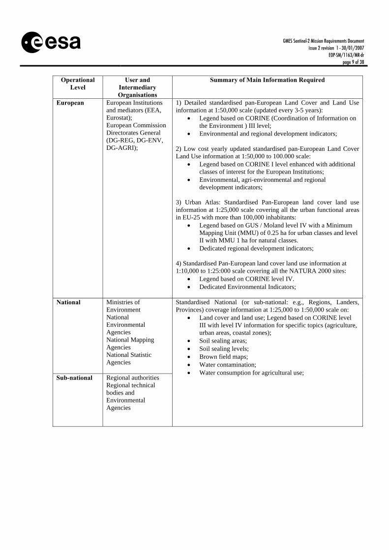
GSE Land is based on the main results related to land issues of the projects SAGE (Service for the Provision of Advanced Geo-Information on Environmental Pressure and State), GMES Urban Services (GUS) and CoastWatch from the GSE consolidation phase. It provides a set of priority information services responding to the main information needs of European users on all levels (DGs, national ministries of environment, regional authorities, municipalities, etc.) with respect to mainly European policies (given priority to Water Framework Directive, Soil Thematic Strategy, Integrated Coastal Zone Management, Urban Environment Thematic Strategy, European Spatial Development Perspective). The GSE Land [RD-7] requirements are summarized in Tab. 1.
GMES Sentinel-2 Mission Requirements Document issue 2 revision 1 - 30/01/2007
EOP-SM/1163/MR-dr page 9 of 38
Operational Level
User and Intermediary Organisations
Summary of Main Information Required
European European Institutions and mediators (EEA, Eurostat); European Commission Directorates General (DG-REG, DG-ENV, DG-AGRI);
1) Detailed standardised pan-European Land Cover and Land Use information at 1:50,000 scale (updated every 3-5 years):
Legend based on CORINE (Coordination of Information on the Environment ) III level;
Environmental and regional development indicators; 2) Low cost yearly updated standardised pan-European Land Cover Land Use information at 1:50,000 to 100.000 scale:
Legend based on CORINE I level enhanced with additional classes of interest for the European Institutions;
Environmental, agri-environmental and regional development indicators;
3) Urban Atlas: Standardised Pan-European land cover land use information at 1:25,000 scale covering all the urban functional areas in EU-25 with more than 100,000 inhabitants:
Legend based on GUS / Moland level IV with a Minimum Mapping Unit (MMU) of 0.25 ha for urban classes and level II with MMU 1 ha for natural classes.
Dedicated regional development indicators; 4) Standardised Pan-European land cover land use information at 1:10,000 to 1:25:000 scale covering all the NATURA 2000 sites:
Legend based on CORINE level IV. Dedicated Environmental Indicators;
National Ministries of Environment National Environmental Agencies National Mapping Agencies National Statistic Agencies
Sub-national Regional authorities Regional technical bodies and Environmental Agencies
Standardised National (or sub-national: e.g., Regions, Landers, Provinces) coverage information at 1:25,000 to 1:50,000 scale on:
Land cover and land use; Legend based on CORINE level III with level IV information for specific topics (agriculture, urban areas, coastal zones);
Soil sealing areas; Soil sealing levels; Brown field maps; Water contamination; Water consumption for agricultural use;

GMES Sentinel-2 Mission Requirements Document issue 2 revision 1 - 30/01/2007
EOP-SM/1163/MR-dr page 10 of 38
Local Local administrations Protected areas managers River and basin authorities
High resolution (1:10,000 to 1:25,000 scale) information for inventorying, assessment and monitoring of protected areas: Base maps; Land cover & land use; Land cover & land use change; Seasonal change analysis (e.g., water cycle); Environmental Indicators;
High resolution (1:10,000 to 1:25,000 scale) information for environmental management of urban areas and spatial planning: Land cover & land use maps; Long and medium term land cover & land use change
identification; Fast change analysis: e.g., for illegal buildings identification and
development control; Sealing levels; Brown fields map; Urban planning support information; Environmental Indicators; Basin wide irrigation information for water management in Mediterranean areas: Land cover & land use; Scale: 1:100,000 to 250,000 Overall thematic accuracy: >80% Geometric accuracy: < 200m Minimum mapping unit 25 – 100 ha
Table 1 User Requirements to GSE Land
The services reflecting these requirements are grouped in four baseline services:
Urban Atlas Service with very high resolution land cover mapping and further downstream services (Urban Atlas Indicators like urban sprawl, environment and regional development indicators and fine-tuning of maps to local needs).
Inland Water Quality Service supported by high resolution regional land cover and agricultural land use mapping and further downstream modelling related to nutrient loss and pesticides.
Impervious Area Service with land-take maps, trend analysis and social-economical impact. Water Abstraction / Irrigation Service with the mapping of arable acreages and the downstream
modelling of irrigation volumes. The mapping services are used for monitoring of urban areas in Europe, covering issues related to urban sprawl, urban planning modelling & forecasting, changes in urban land use, environmental monitoring and enforcement of urban planning discipline. The intention is to implement in the user’s environment products and services derived from satellite data and other sources in close cooperation with mandated users, from local (cities), regional national and European level. The service relies now to a large extent on classification of land cover using optical imagery of the SPOT-High Resolution Visible (HRV) or Landsat-Thematic Mapper (TM) type sensors. These are complemented by very high spatial resolution sensors such as Ikonos and SPOT-5 for mapping of small features (small roads/rivers). Integration of these land cover maps with ancillary data and models lead to the specific downstream services.
GMES Sentinel-2 Mission Requirements Document issue 2 revision 1 - 30/01/2007
EOP-SM/1163/MR-dr page 11 of 38
The water resources services aims at a comprehensive range of products to serve the demands coming from the European Water Framework Directive and the upcoming regulations of the Thematic Strategy on Soil Protection usually referred to as Soil Thematic Strategy. Public and private partners together have established core services addressing basic geo-information needs from the agricultural/environmental community. They mainly address water availability and water stress related issues as well as anthropogenic influence on surface and ground water quality. These services are the basis of customised end-user applications supporting the national and local implementation of the European Water Framework Directive and Soil Thematic Strategy.
3.2.1.2 42BGSE Forest Monitoring
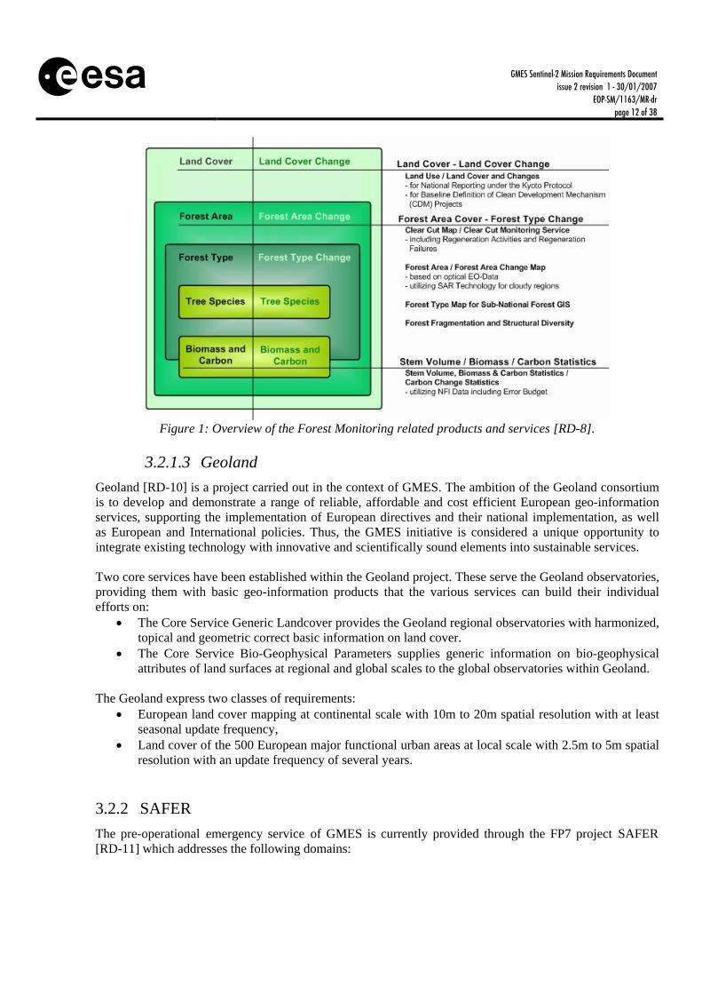
The GSE Forest Monitoring [RD-8] addresses the policy related demands for securing the ecological functions in the forestry and land use sector. Existing infrastructural systems and data sources were reviewed and utilised in order to develop forest monitoring services such as yearly carbon balance information, forest disturbance data, as well as products for practical forest and land use management. For a national coverage cloud free data is needed within one growing season (preferably within 2 months window in Scandinavia). A service portfolio of validated products and services was provided by the monitoring service and delivered standardised spatially referenced, quality products, e.g. maps that are cost effective, readily accessible and transparent to users, thereby promoting key applications and good governance within the forestry sector with sustainability as a paramount consideration. GSE FM is also connected with a partner project named Kyoto Inventory. The Kyoto Inventory (KYOTO INV) [RD-9] is a component of the ESA Data User Programme (DUP). It defines and develops key inputs required for UNFCCC (United Nations Framework Convention on Climate Change) and Kyoto reporting including area assessments and classifications for forests and country-specific land use. Potentially, Sentinel-2 observations could also contribute to the Baseline Mapping Service for the UN Collaborative Programme on Reduced Emissions from Deforestation and Degradation in Developing Countries (REDD). With a post Kyoto agreement in place the whole forested area in the tropical belt shall be covered twice a year representing the wet and dry seasons. To monitor illegal logging monthly coverage is desirable. Figure 1 summarizes the main products and services included in this GSE.
GMES Sentinel-2 Mission Requirements Document issue 2 revision 1 - 30/01/2007
EOP-SM/1163/MR-dr page 12 of 38
Figure 1: Overview of the Forest Monitoring related products and services [RD-8].
3.2.1.3 43BGeoland
Geoland [RD-10] is a project carried out in the context of GMES. The ambition of the Geoland consortium is to develop and demonstrate a range of reliable, affordable and cost efficient European geo-information services, supporting the implementation of European directives and their national implementation, as well as European and International policies. Thus, the GMES initiative is considered a unique opportunity to integrate existing technology with innovative and scientifically sound elements into sustainable services. Two core services have been established within the Geoland project. These serve the Geoland observatories, providing them with basic geo-information products that the various services can build their individual efforts on:
The Core Service Generic Landcover provides the Geoland regional observatories with harmonized, topical and geometric correct basic information on land cover.
The Core Service Bio-Geophysical Parameters supplies generic information on bio-geophysical attributes of land surfaces at regional and global scales to the global observatories within Geoland.
The Geoland express two classes of requirements:
European land cover mapping at continental scale with 10m to 20m spatial resolution with at least seasonal update frequency,
Land cover of the 500 European major functional urban areas at local scale with 2.5m to 5m spatial resolution with an update frequency of several years.
3.2.2 38BSAFER
The pre-operational Hemergency serviceH of GMES is currently provided through the FP7 project HSAFERH [RD-11] which addresses the following domains:

GMES Sentinel-2 Mission Requirements Document issue 2 revision 1 - 30/01/2007
EOP-SM/1163/MR-dr page 13 of 38
Civil protection Humanitarian aid Security crises
HSAFERH addresses potentially all types of disasters or crises: natural disasters (floods, fires, landslides, storms, earthquakes, etc.), technological accidents, humanitarian crises (for instance after a severe drought period), civilian-military crises. In the domain of emergency management, Hnumerous projectsH paving the way towards a pre-operational GMES service have been funded by European institutions over the last years. These include projects such as Respond and RISK-EOS.
3.2.2.1 44BGSE RISK-EOS
All countries are subject to natural hazards of different types, such as forest fires, floods, avalanches, landslides, earthquakes, volcanic eruptions and storms. Recent analyses, such as those ones conducted by re-insurance companies, have shown an increased number of natural disasters and in particular of meteorological events. The increase of the population density and the development of our society have brought in many areas an increase of the threat caused by natural hazards. The topic of natural hazards related to meteorological events has come over the last years to the political agenda of most of the European countries and to the opinion of their citizens, due to a series of major events with large effects such as the repeated floods in Central Europe and the recent devastating forest fires in the Mediterranean countries. These natural hazards are a major cause of loss of life and property, and may also impact some important environmental resources. Hence the need to better manage these hazards through a more efficient use of geo-spatial observations, improving our ability to better predict, monitor, mitigate, and respond to these natural hazards. Reducing the impact of these disasters requires a better integration of observations from various Earth Observing systems, some improved predictive modelling, and the dissemination of timely and accurate information needed by all actors involved the mitigation of these disasters. It is one of the objectives of GMES to set-up a European operational service capacity, taking benefit of Earth Observation capabilities in combination with other data sources and models, to help institutionally mandated organisations to better manage natural hazards, throughout the prevention, anticipation, response and post-response phases Started in 2003, RISK-EOS [RD-12] aims at delivering operational geo-information services to support the management of meteorological hazards such as floods and forest fires and to a minor extent of other natural hazards throughout all phases of the disaster reduction (prevention, early warning, crisis, post crisis). The RISK-EOS services combine the use of satellite observation data (some provided in near real time, NRT) with exogenous data and modelling techniques. They are targeted to serve the needs of all risk management actors at European, National and Regional levels (Civil protections, fire fighting and rescue services, Land planning and risks prevention services, Territorial communities). Figure 2 summarizes the main services covered by GSE RISK-EOS.

GMES Sentinel-2 Mission Requirements Document issue 2 revision 1 - 30/01/2007
EOP-SM/1163/MR-dr page 14 of 38
Figure 2: Summary of the services offered by the GSE RISK-EOS [RD-12].
Amongst the operational services delivered by the RISK-EOS service network, those that shall be supported by Sentinel 2 observations are:
Assets Mapping: yearly mapping of areas subject to natural hazards, to provide regularly updated cartography of urban areas, isolated buildings, infra-structures, and their evolution in time, by using high and very high resolution optical imagery respectively for deca-metric products (5-10 m resolution) and metric products (1-5 m resolution). This multi-risk service aims at maintaining up to date information on assets, improving the knowledge of risk prone areas and the possible impact of natural disasters. This service is intended to be a local service, close to the users in order to be adapted to their local specificities, needs and existing data and standards (e.g. cartographic databases).
Flood Risk Analysis: production and integration of geo-information data to support flood risk management activities. This service aims at providing geo-information about past and potential flood events as well as estimations of potential damages and losses. By integrating these data into management systems such as Flood Information Systems, an efficient and supportive use of flood-related information is enabled. This service is available on user request and builds on Earth Observation data as well as on ancillary data sets and modelling techniques. The delivered geo-information is targeted to support flood prevention and post-crisis management.
Burn Scars Mapping: provision of seasonally (after the summer and winter fire seasons) information products regarding burned areas mapping and environmental loss estimates at high-resolution to support fire fighting planning, environmental and natural resources planning and land conservation planning at regional/provincial levels.
Rapid Mapping: dedicated to the response management of civil protection and rescue services, this service provides rapid mapping products showing the instantaneous extent and impact of natural disasters. First products are needed within 8 h after user request. These products are generated using any available and exploitable Earth Observation (EO) crisis image (high and very high resolution, Optical / Radar). In the case of long duration disasters, daily products are required.
3.2.2.2 45BGSE RESPOND
The objective of this GSE [RD-13] is to increase the efficiency and effectiveness of the European and international humanitarian community through the appropriate and reliable application of geographic

GMES Sentinel-2 Mission Requirements Document issue 2 revision 1 - 30/01/2007
EOP-SM/1163/MR-dr page 15 of 38
information. The main target users of GSE RESPOND are the EC (DG ECHO, DG RELEX, DG ENV/MIC), the United Nations (UN) (for instance the UN Office for Coordination of Humanitarian Affairs (OCHA), the UN High Commissioner for Refugees (UNHCR), UN Department of Peace Keeping Operations (UNDPKO), the Red Cross and Non-Governmental Organizations (NGOs). GSE RESPOND provides a range of services supporting the entire humanitarian intervention cycle (Figure 3). GES RESPOND will provide support to humanitarian organisations throughout the intervention cycle. It will provide information for preparedness activities (pro-active) and for relief activities (reactive). GSE RESPOND supports both slow and fast onset crises (e.g. Famine – Slow, and Earthquake – Fast). Geographic Information (GI) has been proven useful to organisation working in this arena for a large variety of applications from ensuring the rapid deployment of relief following a disaster to planning reconstruction and development activities during long term recovery.
Figure 3: The humanitarian intervention cycle (source: UNITAR).
The GSE Respond service supports:
Pure mapping as well as satellite derived information. Support services – training & in field support. Support to forecasting & alert services.
The intention is to seek to exploit economies of scale and improved information by supplying products to different types of users based on the same data components to provide a reliable and guaranteed service. Pure mapping as well as satellite-derived classification and change detection related information is used for the services, in complementing very high resolution missions as outlined in Table 2. GSE RESPOND supports these activities via 8 key services. These are:
Basic Mapping Service (digital and paper maps and map archive utilising both EO and non-EO data sources and providing the baseline for other services)
Crisis and Damage Mapping Service (digital and paper maps created quickly and detailing the effects of a given crisis)

GMES Sentinel-2 Mission Requirements Document issue 2 revision 1 - 30/01/2007
EOP-SM/1163/MR-dr page 16 of 38
Situation Mapping Service (maps and GIS layers made available to field users for rapid update, these maps particularly rely on field information to ensure update accuracy)
Refugee and Internally Displaced People (IDP) Support Mapping Service (includes both maps and GIS layers, detailing Refugee camps, water sources, health resources etc)
Thematic Mapping Service (basic mapping with additional information such as health mapping, environmental mapping, maps for prevention/reconstruction purposes)
Alert Services (complementing web alert systems with mapping information) Communication / Reporting Services (ad hoc mapping and graphics) In-Field Data Collection and Field Mapping Service (this supports the other services by
providing information from the field; it also serves to train users/potential users during a crisis situation).
A large portion of the RESPOND portfolio of services is concerning emergencies: Crisis/Damage mapping service, Situation maps, Refugee camp monitoring, Alert services, Health mapping services. This is particularly the case with Crisis/Damage mapping services which are in response to either activation of the International Charter Space and Major Disasters or for other (non-Charter) activations e.g. conflicts in the context of humanitarian crisis events. For these services concerning emergencies, timeliness of information supply is of the essence, hence rapid delivery of (fresh and archive) EO data is essential, within hours rather than days. When monitoring such situations a daily (or weekly) re-visit time is often required. Typically, disaster management organisations (e.g. typically European Civil Protection Authorities acting outside Europe, UN OCHA, World Food Programme (WFP), etc.) require background mapping ex-archive within 6 hours (typically 2 hours) and crisis/damage mapping information within 24 hours and on a daily basis. Spatial scale requirements vary between services. In the case of high resolution basic mapping and refugee camp mapping, the primary source of EO data required are optical high and very high resolution imagery (in particular in the case of urban environment) with resolutions of 1-2.5m while for Crisis and damage mapping and situation mapping 2.5-10 m resolutions are required.
3.2.3 39BG-MOSAIC
The pre-operational Hsecurity serviceH of GMES is currently provided through the FP7 project HG-MOSAICH and the FP6 project HLIMESH [RD-14]. These two projects, which combine Earth observation technologies with communication and positioning technologies, address the following domains:
Maritime surveillance: sea border surveillance in and outside Europe, illegal immigration and illegal trafficking surveillance, safety sea lane/piracy/sensitive cargo…
Infrastructure Surveillance: land border surveillance, critical infrastructure (e.g. pipelines)… Support to peace-keeping: population monitoring, resources (water), … Support intelligence and early warning Support crisis management operations
Before HG-MOSAICH and HLIMESH, Hseveral projectsH dealing with different aspects of security have been funded by European institutions, such as Global Monitoring for Food Security (GMFS).

GMES Sentinel-2 Mission Requirements Document issue 2 revision 1 - 30/01/2007
EOP-SM/1163/MR-dr page 17 of 38
3.2.3.1 46BGSE GMFS
The objective of the GSE GMFS [RD-15] is to provide Earth observation based services to support monitoring of food security and related environmental processes (Figure 4). It aims to assist stakeholders, national governments and international organisations to better implement their policies towards sustainable development. The GMFS services are tailored to meet the information requirements of specific core users and currently include two applications:
Continental scale monitoring, aiming at continuous monitoring of vegetation state by analysing long-term Earth observation time-series (usually on a 10 days basis).
National monitoring, mainly aiming at supplying detailed information for major food crops, such as the planting date and the national extent of cultivation. These products are delivered once or twice per growing season.
Additional important parts of the service are the in-situ data collection, including field data used for validation purposes and as input for agro-meteorological modelling.
Figure 4: Schema presenting the role of GMFS in the international context [RD-15].
Specific services addressing these user needs are:
Support to Crop and Food Supply Assessment Missions (CFSAM). The Geo-information packages provided contain a compilation of purely satellite derived data, differing based upon the specific requirements of the Food and Agriculture Organization (FAO) and WFP, the country considered and based upon the available data.
Early warning with the HVegetation Productivity Indicator (VPI)H. Agricultural mapping with the products Hcrop emergence dateH, Hcultivated areaH, Hextent of
cultivationH and aHgricultural productivity. H
Crop Yield assessment realized at (sub-) national level up to the departmental level.

GMES Sentinel-2 Mission Requirements Document issue 2 revision 1 - 30/01/2007
EOP-SM/1163/MR-dr page 18 of 38
3.2.4 40BGMES FAST TRACK SERVICES
These Fast Track Services (FTS) aimed at developing and validating pilot operational services and finished in 2008. Two GMES FTS are particularly relevant for Sentinel-2:
LMCS (Land Monitoring Core Service) [RD-4]. ERCS (Emergency Response Core Service) [RD-5].
3.2.4.1 47BLMCS
LMCS aims at providing reliable, affordable and cost efficient European geo-information services, for supporting the implementation of European and International directives/policies. It is its goal to provide timely, continuous and independent observations about the use of soil and other land resources and the changes of the land environment for responsible and farsighted policy-making at all levels (European to local). Core information services should feed predictive models of climate change, development of resources, impacts of human actions and provide citizens with location-based data for their daily decisions. Land monitoring is a quite complex task since it covers a wide range of resources and variegated policies: soils, water, agriculture, forests, ecology sites, energy and utilities, build-up areas, recreation, infrastructures and transports. It will address a large variety of user requirements related to European policies and international commitments. The European Policy drivers for land monitoring have been already identified in detail in the conclusions of the “GMES User Workshop on a Land Monitoring Service for Europe” of October 2005 as:
Environmental policies, i.e. climate change, nature protection and biodiversity, natural resources, environmental hazards, environmental impact assessment,
Regional policies, territorial cohesion and European spatial development perspectives, Common Transport Policy, Enterprise, EU development policies, Common Agricultural Policy (CAP).
EU agencies and EC offices have mandates for regular information provision related to land, such as:
European Environmental Agency (EEA): land use data centre (core land cover data, CORINE), land and ecosystem accounting
DG-ESTAT: application of aerial survey and remote sensing to agricultural statistics (LUCAS [Land-use change analysis system]for 1999-2007), GISCO (Geographic Information System for the Commission) database
EUSC (EU Satellite Centre): support to EO police/military operations, support to humanitarian missions, event planning, treaty verification
At international level, the EC is a party to many International Environmental Agreements such as the Rio Conventions, requiring data and reporting on land use and land cover changes:
UNFCCC and its Kyoto Protocol UN Convention to Combat Desertification (UNCCD) UN Convention on Biological Diversity (UNCBD) UN Economic Commission for Europe (UNECE) Long Range Transboundary Air Pollution
Deposition

GMES Sentinel-2 Mission Requirements Document issue 2 revision 1 - 30/01/2007
EOP-SM/1163/MR-dr page 19 of 38
and is supporting the:
UN Forum on Forest with the related “FLEGT ” policy whereby EU contributes to the transparency of the international timber market,
UN Millennium Development Goals, where Goal I pledges to improve food and nutrition security.
3.2.4.2 48BEmergency Response Core Service
The objective of the ERCS is to reinforce the European capacity to respond to Emergency situations associated with meteorological driven-hazards (e.g. storms, fire, floods) geophysical hazards (e.g. earthquakes, tsunamis, volcanic eruptions, landslides), deliberate and accidental man-made disasters and humanitarian disasters. Its initial scope is to provide rapid mapping services, including preparatory services to collect and map spatial and socio-economic in areas at risk. In the longer term it will expand beyond the crisis phase to include the crisis prevention and early warning phases, post crisis reconstruction and situation assessments. Two families of rapid mapping services will be provided: “Reference Maps” derived from data available pre-crisis, and “Assessment maps” generated during the crisis. GMES Emergency Response services are world wide; however the following should be considered as priority areas:
For Natural Disasters: all regions where international assistance may be solicited and primarily Central America, Eastern Africa and South-East Asia
For Complex emergencies: all regions where international assistance may be solicited primarily Central Africa and Middle East
3.3 15BSummary of User Information Requirements The user requirements coming from the GMES Fast-Track Services, GSEs and Geoland in terms of applications and associated Level 2/Level 3 products are summarized in Tab. 2. The requirements concerning the GSEs described in this document are traceable to the related GSE End User Requirements surveys.
UService UApplication(s) UEO Level 2/3 product USpatial reso-lution
UGeographical Coverage
UUpdate frequency
Overview reference and damage maps
5-10m Global on demand Emergency Response
Detailed reference and damage maps
1-2.5m Global on demand GMES Fast Track Services
Land Monitoring Land cover map (LCM), land use and geo-biophysical maps
10 – 20m Europe 1 to 5 years
National greenhouse gas reporting
Land cover and forest map 10 m
Europe, parts of Asia, Africa and South-America
every 1 – 5 years
GSE Forest Monitoring Clean Development
mechanisms, monitoring disturbances, inventory update
Land cover and forest map 5-30 m
Europe, , Russia, parts of Asia,
Africa and South-America
every 1 – 5 years

GMES Sentinel-2 Mission Requirements Document issue 2 revision 1 - 30/01/2007
EOP-SM/1163/MR-dr page 20 of 38
Urban Atlas Land cover map with emphasis on urban classes
1-2.5 m European Cities 5 years
Inland Water Quality Land cover and land use map 10-25 m Europe 3 – 5 years Water abstraction pressure by irrigation
Land cover and land use map 100-300
m Europe <= 10 days
Land cover map (national level) 20-30 m Europe 3 – 5 years
GSE Land
Impervious Areas / Soil sealing Land cover map (regional level) 10 m Europe 1 – 3 years
Land cover map on continental and regional scale (vegetation state)
250 – 1000 m
Africa, every
10 days
GSE GMFS Regional applications vegetation monitoring
Land cover map on national and subnational scale (crop/no-crop extent of cultivation, planting date, etc.)
20-30 m Africa, yearly
Assets Mapping urban area detection urban evolution
5-10 m 5-10 m
Europe Yearly
Flood Risk Analysis Past event flood mapping Flood Event Simulation (LCM) Potential Loss Assessment (LCM)
5-10 m 5-10 m 5-10 m
Europe Daily
Annual Annual
Burn Scars Mapping Seasonal burn scar perimeter Seasonal fire damage assessment
10-15 m 10-15 m
Southern Europe (Mediterranean
countries)
before / during/ after
each fire season
Rapid Mapping (flood monitoring)
NRT flood extent rapid mapping NRT flood impact rapid mapping Non NRT flood extent mapping Non NRT max flood extent mapping Non NRT flood damage assessment Non NRT flood duration per area
< 30m < 30m < 10m < 10m < 10 m < 10m
Europe
within 12h within 12h
daily daily daily daily
GSE RISK-EOS
Rapid Mapping (large fires)
NRT fire extent rapid mapping Non NRT fire extent mapping Non NRT fire damage assessment
5-10 m 5-10 m 5-10 m
Southern Europe (Mediterranean
countries)
within 1day2 weeks
after event
Basic mapping at large scale
30-500m (5-15m for data capture)
Global Weekly
Basic mapping at medium scale
10-30m (5-15m for data capture)
Global Weekly
Basic mapping at small scale 1 – 2.5 m Global Weekly Crisis/damage mapping (general case)
2.5m to 10 m
Global Daily
Crisis/damage mapping (Plain Flood Monitoring)
10-30m Global Daily
Situation mapping – medium scale 2-25m Global Weekly Situation mapping – small scale 1-2.5m Global Weekly Refuge support maps- small scale 1-2.5m Global Weekly Refugee / IDP support maps – medium scale
2.5-5m Global Weekly
Thematic mapping (including maps for prevention, reconstruction, health and environmental impact assessment) – small scale
1-2.5m Global Weekly
GSE RESPOND
Mapping, Damage Assessment & Thematic mapping for humanitarian aid and disaster management purposes (including services in rush provision)
Thematic mapping (including maps for prevention, reconstruction, health and environmental impact assessment) – small – medium scale
2.5-5m Global Weekly

GMES Sentinel-2 Mission Requirements Document issue 2 revision 1 - 30/01/2007
EOP-SM/1163/MR-dr page 21 of 38
Thematic mapping (including maps for prevention, reconstruction, health and environmental impact assessment) – medium – large scale
10-20m Global Weekly
Land cover and use map 20m Regional Weekly Geoland
Monitoring of land cover and vegetation Geo-biophysical variables 20m Regional Weekly
Table 2: Summary of the product requirements derived from the main GSEs and Geoland.
The need to assess simple processes and disturbances in vegetation and inland waters postulates the capability to quantitatively retrieve a limited set of vegetation, soil and water variables. They should be estimated at a regional as well as global scale given the appropriate temporal resolution. Two priority main families of products have been identified:
Generic land cover maps (for generic services such as GLC 2000 [RD-16] and CORINE [RD-17]). Maps of geo-biophysical variables (e.g. leaf area index or water content).
Given the temporal variability of terrestrial processes, land cover and associated geo-biophysical variables change rather rapidly. The priority products have therefore to be ensured at a timescale compatible with these processes and associated land cover change. It should be noted that the availability of Sentinel-2 does provide the capability to deliver a range of further services outside of the two priorities listed above. Requirements for these services will be considered as additional capabilities not as driving requirements for the mission.
4 3BMISSION OBJECTIVES GMES will use Sentinel-2 along with other optical satellites to provide complete observations. Conversely, Sentinel-2 will be a member of the land surface imaging constellation of the international Committee on Earth Observation Satellites (CEOS), who will coordinate access to the missions of the same type (especially for Landsat data continuity) to improve the final information for users. Sentinel-2 will ensure European independence while contributing to the global push for improved land imaging. These goals have driven the design towards a dependable multi-spectral Earth-observation system that ensures continuity for Landsat and SPOT observations and improves data availability for users. That, in turn, has identified priority improvements over past satellites. MO-ID Objective MO-S2-01 S-2 shall provide systematic global acquisitions of high-resolution multi-
spectral imagery with a high revisit frequency. MO-S2-02 S-2 shall provide enhanced continuity of multi-spectral imagery provided by
the SPOT series of satellite. MO-S2-03 S-2 shall provide observations for the next generation of operational products
such as land-cover maps, land-change detection maps, and geophysical variables.

GMES Sentinel-2 Mission Requirements Document issue 2 revision 1 - 30/01/2007
EOP-SM/1163/MR-dr page 22 of 38
5 4BMISSION REQUIREMENTS AND ELEMENTS
5.1 16BIntroduction The definition of the Mission Requirements for the Sentinel-2 mission is based on the user information requirements that were summarized in the previous chapter and programmatic constraints. The Mission Requirements cover the end-to-end Earth observation system including high-level instrument requirements, mission operations, data product development and processing, data distribution and data archiving. Mission requirements should be traceable to information requirements defined and agreed with the users. Defining mission requirements would be greatly simplified if the user requirements were less diversified and documented in detail, as they are for instance for meteorological services and sea ice services. Given the variety of terrestrial application-related services, the choice of spatial resolution and spectral bands is difficult to make. In addition, constraints that are not necessarily reflected in the user requirement specifications may also arise. Considering this the Mission requirements as described in the following sections have been identified for the Sentinel 2 mission.
5.2 17BContinuity, Performance and Availability Measurement continuity is needed to guarantee on-going services included in GMES. Continuity of data as provided by these missions is vital to ensure effective exploitation of user investment and any gap in data availability would affect on-going monitoring programs. In this line, continuity is required for services at high spatial resolution such as the ones provided by the SPOT and Landsat satellite systems. Continuity also implies that the performance of the mission services available so far should, as a minimum, be maintained. This means that deviations from technical parameters such as spectral bands for observation and their resolution/sampling and spatial performance should be carefully analysed in order not to jeopardise established applications. Although it may sound trivial it should be noted that an operational mission could only successfully support reliable uninterrupted services if the end-to-end system including space and ground segment is continuously available and robust with back up systems in case of failures. Conflict-free operations are essential. MR-ID Type Value MR-S2-01 Service continuity Start of Operations in a timely manner (target 2013) in
order to ensure continuity to currently existing sensors SPOT and Landsat.
MR-S2-02 Service performance Provide continuity to services provided by exiting sensors (SPOT, Landsat) and enhance them to cover the user information needs expressed in the GSEs (GMES Service Elements) [RD-18], GMES Land Fast Track Services [RD-4] [RD-5], Framework Programme-VI Integrated Project Geoland [RD-19] and DUE (Data User Element) Projects [RD-20] Globcover, Globwetland and Desertwatch.
MR-S2-03 Availability Product availability to the end user shall typically be better than 95%, i.e. the specified products shall provide the specified temporal and spatial coverage, comply with the

GMES Sentinel-2 Mission Requirements Document issue 2 revision 1 - 30/01/2007
EOP-SM/1163/MR-dr page 23 of 38
specified product quality and be delivered to the user within the timeliness specification.
5.3 18BRevisit The geometric revisit time represents the temporal periodicity of systematic acquisition of a given area disregarding cloud cover and under the same viewing direction. The effective revisit time represents the temporal frequency of systematic acquisition of a given area with cloud cover (excluding thin cirrus if thin cirrus clouds can be detected and their effect corrected) below a specified threshold and under the same viewing direction. Based on European cloud cover statistics, a ratio of 3 between the geometric and effective revisits is considered adequate. The revisit requirements here are driven mainly by vegetation monitoring for services included in the GSE GMFS, RISK-EOS and Land. In this context the observing system should be better than SPOT and Landsat as these systems have not high enough revisit frequencies. It should be noted here that revisit requirements may necessitate a system with a constellation of more than one satellite operating at the same time. This would facilitate the satisfaction of the effective revisit requirements for all services relying on land surface classification and vegetation monitoring. MR-ID Type Value MR-S2-04 Geometrical Revisit Not higher than 5 days (goal) / 10 days (threshold) MR-S2-05 Effective Revisit Not higher than 15 days (goal) / 30 days (threshold)
5.4 19BCoverage The geometrical coverage time represents the temporal periodicity of systematic acquisition of a given area disregarding cloud cover and possibly under different viewing directions. The effective coverage time represents the temporal periodicity of systematic acquisition of a given area with cloud cover (excluding thin cirrus if thin cirrus clouds can be detected and their effect corrected) below a specified threshold and possibly under different viewing directions. A weekly to bi-weekly data product update frequency is mainly driven by the GSEs GMFS, Land, and RISK-EOS (Table 2.6.1). MR-ID Type Value MR-S2-06 Geometrical Coverage 3 days (goal) / 5 days (threshold) MR-S2-07 Effective Coverage 9 days (goal) / 15 days (threshold)
MR-ID Type Value MR-S2-8 Deleted. See Change Record.

GMES Sentinel-2 Mission Requirements Document issue 2 revision 1 - 30/01/2007
EOP-SM/1163/MR-dr page 24 of 38
5.5 20BTime of Observation Having an identical or similar observation configuration (i.e. illumination and viewing directions) allows a easier detection of changes on the Earth surface. Considering that the change detection maps is one of the main products required by the user community (e.g. in GSE Land for urban applications or GSE Forest Monitoring), the mission should provide within a period as long as possible observations with identical (or similar) illumination directions (or local solar time) and with an identical (or similar) viewing direction. The periodicity of the identical viewing directions is given by the temporal revisit requirement. The illumination directions of two different acquisitions should be kept as close during the longest possible duration. MR-ID Type Value MR-S2-9
Time of observation Maximize the number of acquisitions with identical (or close) observation configurations (i.e. viewing and illumination directions).
5.6 21BInstantaneous Coverage The monitoring of variables such as vegetation properties associated with Food Security services, catchment properties for hydrological applications as well as the monitoring of natural hazards such as floods and fire risk areas postulates the availability of contextual and synoptic information, which is to a certain extent driving the width of the swath. In the context of instantaneous coverage the influence of directionality on the observed reflectances and derived products should be minimized. For that purpose the observation zenith angle (OZA) should be kept below 15. MR-ID Type Value MR-S2-10 Swath Width 200 km MR-S2-11 OZA 15
5.7 22BTimeliness Timeliness is the temporal span between data acquisition and product delivery to the user. This is an essential requirement for operational services. In this respect, more demanding services are the so-called NRT, which are included in the INSCRIT fast-track services and the GSE RISK-EOS. Requirements for these services correspond to a delivery of the Level 1C products within 3 hours. For the rest of products the delivery time can be relaxed up to 1 day. MR-ID Type Value MR-S2-12 Timeliness Delivery of products up to Level 1C within 3 hours for NRT and 24
hours for the rest.
5.8 23BGeographical Coverage The services provided by the user community include areas all over the world. Although a majority of the applications focus on Europe, still a significant amount of services (e.g. GSE GMFS, GSE RESPOND and Geoland) offer services over all continents.

GMES Sentinel-2 Mission Requirements Document issue 2 revision 1 - 30/01/2007
EOP-SM/1163/MR-dr page 25 of 38
MR-ID Type Value MR-S2-13 Geographical
Coverage All land areas between 56 South latitude (Cape Horn in South America) and 84 North latitude (north of Greenland) including major islands (greater than 100 km2 size), EU islands and all the other small islands located at less than 20 km from the coastline. In addition it is required to acquire the whole Mediterranean Sea, all inland water bodies and all closed seas.
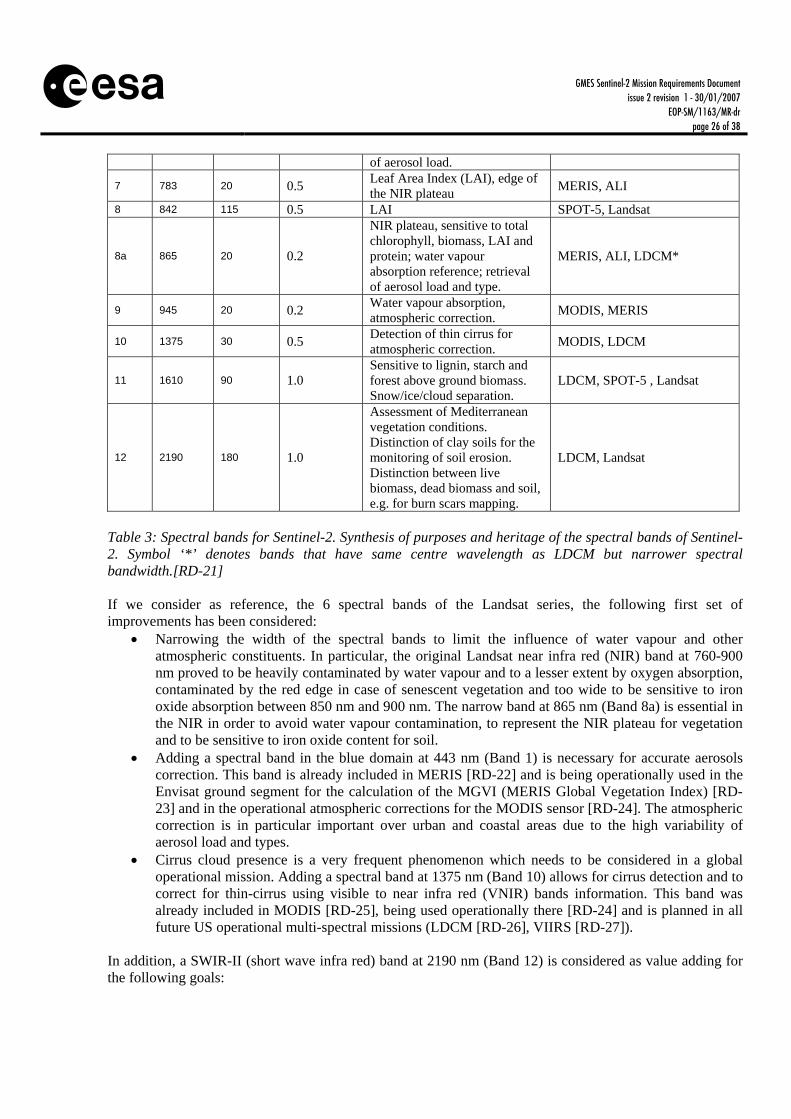
5.9 24BSpectral Sampling The selection of the spectral sampling (i.e width and resolution of the spectral bands) closely depends on the focus of the multi-spectral imaging mission. Whilst for the purpose of merely detecting and mapping land cover/change a more conservative approach is adequate (i.e. a basic set of bands), an improved surface monitoring mission would need a higher amount of spectral bands with narrower widths for an adequate quantification of geo-biophysical variables. Hence, a larger number of bands will enable more accurate classifications, land use change mapping, as well as vegetation status monitoring for agriculture and forestry. To a large extent, the Landsat and SPOT multi-spectral data have been used to develop most of the services included in the GSEs. It is therefore expected that Landsat-5 TM spectral bands would satisfy the current minimum service requirements in areas with extensive regional in-situ information. However, with a view to aspired service advancements in the future, e.g. for improved Land cover/change classification, atmospheric correction, cloud/snow separation and the quantitative assessment of the vegetation status, additional spectral channels are needed. Considering the user information needs for both basic and advanced services, the bands described in Tab. 3 are required to satisfy the mission objectives.
Band #
Center center
(nm)
Spectral width (nm)
Bandwidth knowledge
nm
Purpose Heritage
1 443 20 0.2 Atmospheric correction (aerosol scattering)
MODIS (Moderate Resolution Imaging Spectrometer), ALI (Advanced Land Imager), LDCM (Landsat Data Continuity Mission)
2 490 65 0.5
Sensitive to vegetation senescing, carotenoid, browning and soil background; atmospheric correction (aerosol scattering)
MERIS, LDCM, Landsat
3 560 35 0.5 Green peak, sensitive to total chlorophyll in vegetation.
MERIS, LDCM*, SPOT-5, Landsat
4 665 30 0.5 Max. chlorophyll absorption. MERIS, LDCM*, Landsat
5 705 15 0.2
Position of red edge; consolidation of atmospheric corrections / fluorescence baseline.
MERIS
6 740 15 0.2 Position of red edge, atmospheric correction, retrieval
MERIS
GMES Sentinel-2 Mission Requirements Document issue 2 revision 1 - 30/01/2007
EOP-SM/1163/MR-dr page 26 of 38
of aerosol load.
7 783 20 0.5 Leaf Area Index (LAI), edge of the NIR plateau
MERIS, ALI
8 842 115 0.5 LAI SPOT-5, Landsat
8a 865 20 0.2
NIR plateau, sensitive to total chlorophyll, biomass, LAI and protein; water vapour absorption reference; retrieval of aerosol load and type.
MERIS, ALI, LDCM*
9 945 20 0.2 Water vapour absorption, atmospheric correction.
MODIS, MERIS
10 1375 30 0.5 Detection of thin cirrus for atmospheric correction.
MODIS, LDCM
11 1610 90 1.0 Sensitive to lignin, starch and forest above ground biomass. Snow/ice/cloud separation.
LDCM, SPOT-5 , Landsat
12 2190 180 1.0
Assessment of Mediterranean vegetation conditions. Distinction of clay soils for the monitoring of soil erosion. Distinction between live biomass, dead biomass and soil, e.g. for burn scars mapping.
LDCM, Landsat
Table 3: Spectral bands for Sentinel-2. Synthesis of purposes and heritage of the spectral bands of Sentinel-2. Symbol ‘*’ denotes bands that have same centre wavelength as LDCM but narrower spectral bandwidth.[RD-21]
If we consider as reference, the 6 spectral bands of the Landsat series, the following first set of improvements has been considered:
Narrowing the width of the spectral bands to limit the influence of water vapour and other atmospheric constituents. In particular, the original Landsat near infra red (NIR) band at 760-900 nm proved to be heavily contaminated by water vapour and to a lesser extent by oxygen absorption, contaminated by the red edge in case of senescent vegetation and too wide to be sensitive to iron oxide absorption between 850 nm and 900 nm. The narrow band at 865 nm (Band 8a) is essential in the NIR in order to avoid water vapour contamination, to represent the NIR plateau for vegetation and to be sensitive to iron oxide content for soil.
Adding a spectral band in the blue domain at 443 nm (Band 1) is necessary for accurate aerosols correction. This band is already included in MERIS [RD-22] and is being operationally used in the Envisat ground segment for the calculation of the MGVI (MERIS Global Vegetation Index) [RD-23] and in the operational atmospheric corrections for the MODIS sensor [RD-24]. The atmospheric correction is in particular important over urban and coastal areas due to the high variability of aerosol load and types.
Cirrus cloud presence is a very frequent phenomenon which needs to be considered in a global operational mission. Adding a spectral band at 1375 nm (Band 10) allows for cirrus detection and to correct for thin-cirrus using visible to near infra red (VNIR) bands information. This band was already included in MODIS [RD-25], being used operationally there [RD-24] and is planned in all future US operational multi-spectral missions (LDCM [RD-26], VIIRS [RD-27]).
In addition, a SWIR-II (short wave infra red) band at 2190 nm (Band 12) is considered as value adding for the following goals:

GMES Sentinel-2 Mission Requirements Document issue 2 revision 1 - 30/01/2007
EOP-SM/1163/MR-dr page 27 of 38
Improved assessment of Mediterranean vegetation conditions, as underlined in the GEOLAND Requirements on EO Space & Ground Segment [RD-10].
Distinction of clay soils for the monitoring of soil erosion [RD-28]. Distinction between live biomass, dead biomass and soil [RD-29], e.g. for burn scars mapping.
On top of these additional bands, the characterisation of the vegetation red-edge is considered in the framework of the GMES programme as highly relevant and important for the following applications:
Vegetation classification. An additional number of spectral bands in the red-edge would allow increasing the number of classes and improving the accuracy of the land cover classification. The land cover map is one of the most important products in the GSEs [RD-18] and an improvement of classifications over vegetations would be specially appreciated by the GSEs Forest Monitoring (problems distinguishing forest and grassland using LANDSAT data are mentioned), Land, GMFS and RISK-EOS. Classification improvements using red-edge information have been demonstrated with airborne data (Compact Airborne Spectrographic Imager (CASI; [RD-30]), Airborne Visible Infrared Imaging Spectrometer (AVIRIS), Hyperspectral Mapper (Hymap), etc.) and space borne sensors such as CHRIS-Proba (Compact High Resolution Imaging Spectrometer – Project for Onboard Autonomy) and Hyperion [RD-23].
Determination of the vegetation status and health. Forest and crop biophysical variables are required for some of the GSE applications [RD-18], e.g. National greenhouse gas reporting in GSE Forest Monitoring; Agro-environmental indicators in GSE Land; Regional applications for vegetation monitoring in GSE GMFS; Vegetation monitoring in GSE RISK-EOS.
The use of the red-edge information is already being operationally exploited by the Envisat/MERIS mission and an operational product is being distributed, the so-called “MERIS Terrestrial Chlorophyll Index” (MTCI) [RD-31]. Accurate vegetation characterisation and improved land cover mapping can be reached adding three spectral bands in the red-edge domain (705 nm, 740 nm and 783 nm) plus one band at 945 nm (Band 9) to correct from water vapour absorption effect. A water vapour correction band is already included in operational missions like Envisat/MERIS (located at 900 nm), MODIS or the Visible Infrared Imager Radiometer Suite (VIIRS). Any operational mission requiring multi-temporal data comparisons and aiming at quantitative retrieval of operational land variables needs to produce bottom-of-atmosphere radiometric measurements. This objective can only be reached through a proper atmospheric correction by including the atmospheric correction bands. If these bands to improve classification accuracy and exploit the red-edge information are added, we finally reach a final set composed of 13 spectral bands. The final set of bands (Table 3.10.1) is recommended in order to satisfy a vast majority of the requirements expressed by the users. This set of bands covers the mission needs in terms of land use mapping, land cover change detection and retrieval of geo-biophysical variables. All the proposed spectral bands proposed have been implemented and operationally used (or planned) for the space missions listed in the right column of Table 3.10.1. With a view to the relatively narrow bandwidths, aspired for improved land cover classification and geo-biophysical variable retrievals, high accuracy of position and width of the spectral bands should be ensured.
GMES Sentinel-2 Mission Requirements Document issue 2 revision 1 - 30/01/2007
EOP-SM/1163/MR-dr page 28 of 38
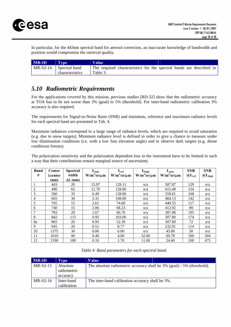
In particular, for the 443nm spectral band for aerosol correction, an inaccurate knowledge of bandwidth and position would compromise the retrieval quality. MR-ID Type Value MR-S2-14 Spectral band
characteristics The required characteristics for the spectral bands are described in Table 3.
5.10 25BRadiometric Requirements For the applications covered by this mission, previous studies [RD-32] show that the radiometric accuracy at TOA has to be not worse than 3% (goal) to 5% (threshold). For inter-band radiometric calibration 3% accuracy is also required. The requirements for Signal-to-Noise Ratio (SNR) and minimum, reference and maximum radiance levels for each spectral band are presented in Tab. 4. Maximum radiances correspond to a large range of radiance levels, which are required to avoid saturation (e.g. due to snow targets). Minimum radiance level is defined in order to give a chance to measure under low illumination conditions (i.e. with a low Sun elevation angle) and to observe dark targets (e.g. dense coniferous forests). The polarization sensitivity and the polarization dependent loss in the instrument have to be limited in such a way that their contributions remain marginal source of uncertainty.
Band #
Center center
(nm)
Spectral width (nm)
Lmin W/m2/sr/m
Lref W/m2/sr/m
Lhigh W/m2/sr/m
Lmax W/m2/sr/m
SNR @Lref
SNR @Lhigh
1 443 20 15.97 129.11 n/a 587.87 129 n/a 2 490 65 11.70 128.00 n/a 615.48 154 n/a 3 560 35 6.49 128.00 n/a 559.01 168 n/a 4 665 30 3.31 108.00 n/a 484.13 142 n/a 5 705 15 2.61 74.60 n/a 449.55 117 n/a 6 740 15 2.06 68.23 n/a 412.92 89 n/a 7 783 20 1.67 66.70 n/a 387.08 105 n/a 8 842 115 0.95 103.00 n/a 307.80 174 n/a 8a 865 20 0.95 52.39 n/a 307.80 72 n/a 9 945 20 0.51 8.77 n/a 232.91 114 n/a 10 1375 30 0.06 6.00 n/a 45.00 50 n/a 11 1610 90 0.40 4.00 32.00 69.78 100 504 12 2190 180 0.10 1.70 11.00 24.60 100 475
Table 4: Band parameters for each spectral band.
MR-ID Type Value MR-S2-15 Absolute
radiometric accuracy
The absolute radiometric accuracy shall be 3% (goal) / 5% (threshold).
MR-S2-16 Inter-band calibration
The inter-band calibration accuracy shall be 3%.

GMES Sentinel-2 Mission Requirements Document issue 2 revision 1 - 30/01/2007
EOP-SM/1163/MR-dr page 29 of 38
accuracy MR-S2-17 Signal-to-
Noise and radiance levels
Signal-to-noise ratio (SNR) and minimum, reference and maximum radiance levels for each spectral band are presented in Table 4.
MR-S2-18 Polarization The polarization sensitivity and the polarization dependent loss in the instrument have to be limited in such a way that their contributions remain marginal source of uncertainty.
5.11 26BQuantization resolution In order to ensure a proper sampling of the radiometric measurement the users require a quantization using at least 12 bits. MR-ID Type Value MR-S2-19 Quantization
resolution Radiometric measurements quantified using 12 bits.
5.12 27BSpatial Resolution The GMES derived User Requirements for spatial resolution varies between 1m and 30m depending on the service required. The applications requiring very high spatial resolution (<10m) are usually associated to low product update frequency and to small geographical areas and can be covered in the frame of national missions e.g. by France (Pleiades, SPOT-5, Venus [Vegetation and Environment monitoring on a New Micro-Satellite]), Germany (RapidEye), UK (DMC) and Spain (Spanish EO satellite), or Third Party Missions (TPM) such as Kompsat-II (Korea Multi-Purpose Satellite II) or ALOS (Advanced Land Observing Satellite). In that respect, Tab. 5 summarizes the features of the main existing and foreseen very-high resolution optical imagers.
Mission name
Pan-chromatic Resolution
(nadir)
Multi-spectral
resolution (nadir)
Swath Time frame Panchromatic Band
Multi-spectral Bands
Pleiades 0.7 m 2.8 m 20 km 2010- 480-830 nm Blue: 430-550 nm Green: 490-610 nm Red: 600-720 nm NIR: 750-950 nm
RapidEye - 6.5 m 78 km 2007-2014 - Blue: 440-510 nm Green: 520-590 nm Red: 630-685 nm Red edge: 690-730 nm NIR: 760-850 nm
Spanish Earth Observation Satellite
2.5 m 10 m 25 km 2014- 593 nm Blue: 451 nm Green: 550 nm Red: 647.5 nm NIR: 872.5 nm
DMC 4 m (optional)
36 m 600 km (MS) 2002- - Red: 520-600nm Green: 630–690nm NIR: 760–900nm
SPOT 5 2.5 m/5 m 10 m 2x60 km 2002- 480-700 nm Green: 500-590 nm Red: 610-680 nm NIR: 780-890 nm SWIR: 1580-1750 nm
LISS-IV on Resourcesat-1
- 5.8 m 23 km (MS) 70 km (MS)
2003- - Green: 520-590 nm Red: 620-680 nm

GMES Sentinel-2 Mission Requirements Document issue 2 revision 1 - 30/01/2007
EOP-SM/1163/MR-dr page 30 of 38
NIR: 770-860 nm Quickbird 0.6 m 2.4 m 16.5 km 2001- 445-900 nm Blue: 450-520 nm
Green: 520-600 nm Red: 630-690 nm NIR: 760-900 nm
Ikonos 1 m 4 m 13 km 2001- 450-900 nm Blue: 450-530 nm Green: 520-610 nm Red: 640-720 nm NIR: 770-880 nm
Table 5: List of current and future very-high resolution multi-spectral sensors satisfying cartographic requirements. For instance, the LMCS [RD-4] and Geoland [RD-19] express two classes of requirements:
European land cover mapping at continental scale with 10 m to 30 m with at least seasonal update frequency,
Land cover of the 500 European major functional urban areas at local scale with 2.5m to 5m with an update frequency of several years.
The second class of products require data from very high resolution sensors. The first class can be covered with a sensor with the spatial resolution features described in Tab. 6. Bands 1, 9 and 10 are sampled at 60m spatial resolution as they are devoted to atmospheric correction purposes. Bands 2, 3, 4 and 8 are sampled at 10m to ensure higher resolution products for some specific applications (e.g. soil sealing mapping, forest mapping for Kyoto Protocol inventory). The rest of bands (5, 6, 7, 8a, 11 and 12) are specified at 20m spatial resolution that is sufficient for the rest of the applications.
Band # 1 2 3 4 5 6 7 8 8a 9 10 11 12 Spatial
Resolution [m]
60 10 10 10 20 20 20 10 20 60 60 20 20
Table 6: Spatial Resolution of the Sentinel-2 spectral bands. MR-ID Type Value MR-S2-20 Spatial Resolution Requirements are described in Table 6.
5.13 28BGeo-location Requirements The process of acquiring remote sensing images introduces a series of distortions coming from the observer (sensor and platform) and the observed (atmosphere and Earth) surface. The data acquired need therefore to be processed in a way to be exploitable by the final user as a geo-located data set, where each pixel can be annotated with its geographical coordinates. The accurate geometric correction of remote sensing images is a key issue in multi-source and multi-temporal data integration, management and analysis [RD-33]. With the advent of GMES, geo-localization will be a central issue. Having a continuous, operational global monitoring concept postulates accurate automatic geo-location in order to reduce/avoid human intervention in the geo-location process.

GMES Sentinel-2 Mission Requirements Document issue 2 revision 1 - 30/01/2007
EOP-SM/1163/MR-dr page 31 of 38
For the VNIR and SWIR domains automatic geo-location accuracy should be better than ±1 pixel of the spatial resolution of the sensor. For multi-temporal observations the co-registration between two images acquired at different times shall be accurate to ±2 pixels. MR-ID Type Value MR-S2-21 Geo-location
accuracy The geo-location accuracy of Level 1C data (i.e. the ortho-rectified image) shall be better than or equal than ±1 pixel rms of the sensor spatial resolution without using ground control points (GCP).
MR-S2-22 Multi-temporal co-registration
The co-registration between two images acquired at different times shall be accurate to ±2 pixels
5.14 29BService Data Products Level 1A, 1B, 1C and a catalogue of Level 2A/2B/3 products shall be made available to the service providers and final users. Service providers are officially recognised entities in charge of elaborating more refined products or products specific for some applications in the frame of the GMES programme. Final users are defined as any generic user benefiting from GMES monitoring data. Definitions of the product levels can be found in chapter 1.5 of this document. The catalogue of potential Level 2A/2B/3 products shall include the products indicated in Table 7. Other identified Level 2B/3 products (indicated in Table 8) will be generated by the service providers and down-stream users.
Abbreviation Name Description Goal
Accuracy Product
Level
ρBOA Bottom-of-Atmosphere Reflectance
Atmospherically-corrected product including cloud screening, and adjacency/slope effects correction.
5% 2A
GLC Generic Land Cover Land cover with a set of basic generic classes compatible with those already used for generic services such as GLC 2000 and CORINE.
TBD 2B
FAPAR Fraction of Absorbed Photosynthetically Active Radiation
Fraction of the radiation in the photosynthetic domain (400-700nm) that is absorbed by leafs. Values range between 0 and 1. Product to provide continuity of MGVI [RD-34]. For Sentinel-2 this index would provide MGVI at high resolution.
RMS=0.05 S/N=21 [RD-34]
2B
LAI Leaf Area Index Map with the green leaf area per unit soil area. 10% 2B
FVC Fraction of Vegetation Cover
% of the land surface covered by vegetation. TBD 2B
Cab Leaf Chlorophyll Content
The amount of chlorophyll per square centimetre. This product would provide continuity of MTCI [RD-31]. For Sentinel-2 this index would provide MTCI at high resolution. This index is directly related to the chlorophyll content of vegetation.
TBD 2B
Cw Leaf Water Content The amount of water in weight (grams) or volume (cubic centimetres) per unit leaf
TBD 2B
GMES Sentinel-2 Mission Requirements Document issue 2 revision 1 - 30/01/2007
EOP-SM/1163/MR-dr page 32 of 38
weight (grams) or volume (cubic centimetres). This parameter can be remotely sensed and is important in estimating the potential of transpiration and the vegetation energy balances.
STS Spatio-Temporal Syntheses of Level 1C or 2A products.
N/A N/A 3
Table 7: List of Level 2A, 2B and Level 3 products required for the Sentinel-2 mission.
Abbreviation Name Description Goal
Accuracy FNPAV Fraction of Non-
Photosynthetically Active Vegetation
Amount of non-photosynthetically active vegetation measured in %.
TBD
SA Surface Albedo Fraction of the incoming radiation reflected by the surface.
TBD
BS Burn Scars Map of the areas affected by fire events. TBD FL Fuel Load Fuel load for wild artificial fires. TBD SFRI Structural Fire Risk Index For more details see Risk-EOS GSE report. TBD CD Crown Density For more details see Forest Monitoring GSE
report. TBD
FA Forest Age For more details see Forest Monitoring GSE report.
TBD
FM Flood Monitoring For more details see Risk-EOS GSE report. TBD
CDM Change Detection Map Product indicating major land use conversion processes.
TBD
SC Snow Cover Fraction of the surface covered by snow. TBD Table 8: List of Level 2B and Level 3 products that will be generated by the GMES core services and down stream users.
MR-ID Type Value MR-S2-23 Data products Users shall have access to Levels 1A, 1B, 1C and a catalogue of Level
2A/2B/3 products to be identified from Table 7.
6 5BSYSTEM CONCEPT OVERVIEW
6.1 30BMission Overview Sentinel-2 satellites will routinely provide high resolution (10–20 m) optical images globally with frequent revisits tailored to the needs of GMES land and emergency services. Sentinel-2 aims at ensuring continuity of SPOT- and Landsat-type multi-spectral data, with improvements to allow service evolution. The first launch is expected in 2013.

GMES Sentinel-2 Mission Requirements Document issue 2 revision 1 - 30/01/2007
EOP-SM/1163/MR-dr page 33 of 38
Frequent revisits and high mission availability require two Sentinel-2 satellites operating simultaneously, which dictates a small, cost-effective and low-risk satellite. The orbit is Sun-synchronous at 786 km altitude (14+3/10 revolutions per day) with a 10:30 a.m. descending node. This local time was selected as the best compromise between minimising cloud cover and ensuring suitable Sun illumination. It is close to the Landsat local time and matches SPOT’s, allowing the seamless combination of Sentinel-2 data with historical images to build long-term time series. The two satellites will work on opposite sides of the orbit.
6.2 31BSpace Segment A compact 1200 kg satellite will be launched on ESA’s Vega (baseline, with Rockot as backup). The satellite is designed for a 7-year lifetime, with propellant for 12 years of operations, including end-of-life de-orbiting. The satellite configuration in deployed and stowed configuration is depicted on Fig. 5. The satellite is controlled in 3-axes via high-rate multi-head star trackers and fiber optics gyroscopes, mounted on the payload structure for better pointing accuracy and stability, and a GNSS receiver. Power comes from high-efficiency gallium arsenide triple junction solar cells and a lithium-ion battery. Images are stored in a 2.4 Tbit solid-state mass memory before down linking at 520 Mbit/s in the X-band. Command and control is performed through an omni-directional S-band antenna.
Figure 5: Sentinel-2 Spacecraft The MultiSpectral Instrument (MSI) features a three-mirror anastigmat telescope with a pupil diameter of about 150 mm; it is the key to the high image quality across the wide field of view of 290 km (Landsat 185 km, SPOT 120 km). The telescope structure and mirrors are made of silicon carbide to minimise thermal deformation. The VNIR focal plane employs monolithic CMOS (complementary metal oxide semiconductor) detectors, while the SWIR uses a mercury-cadmiumtelluride detector hybridised on a CMOS read-out circuit. A dichroic beam-splitter separates the VNIR and SWIR channels. A combination of onboard calibration, using a Sun diffuser, and calibration with ground targets will guarantee high radiometric performance. The detector signals are digitised at high resolution (12-bit), and state-of-the-art lossy data compression reduces the data volume. The compression ratio will be fine-tuned for each spectral band to ensure that there is no significant effect on image quality.

GMES Sentinel-2 Mission Requirements Document issue 2 revision 1 - 30/01/2007
EOP-SM/1163/MR-dr page 34 of 38
6.3 32BGround Segment and Data Processing The Sentinel-2 Ground-Segment is composed of the Flight Operations Segment (FOS) and the PDGS (Payload Data Ground Segment). The FOS is responsible for all flight operations of the Sentinel-2 spacecrafts including satellite tasking, telecommanding and telemetry monitoring, flight dynamics monitoring and orbit control. It will be operated at ESA’s European Space Operations Centre (ESOC) in Darmstadt in Germany during the entire Sentinel-2 mission. The PDGS is responsible for payload and downlink planning, data acquisition and processing of the Sentinel-2 satellite data, while contributing to the overall monitoring of the payload and platform in coordination with the FOS. The PDGS is a distributed ground-system including ground-stations, processing centres and embedding all additional third-party centres falling in the scope of its responsibilities for Sentinel-2 (e.g. auxiliary data providers). The GSCDA (GMES Space Component Data Access) system is not considered part of the Sentinel-2 mission ground segment as providing multi-mission services within the GSC (GMES Space Component) and as such is not strictly dedicated to Sentinel-2 (Fig. 6).
Figure 6: Sentinel-2 Mission Context Level-1C processing comprehensively includes radiometric and geometric corrections including ortho-rectification and spatial registration on a global reference system with sub-pixel accuracy to allow multi-

GMES Sentinel-2 Mission Requirements Document issue 2 revision 1 - 30/01/2007
EOP-SM/1163/MR-dr page 35 of 38
temporal applications. The MSI Level-1C product will provide TOA reflectance measurements with all metadata necessary to convert in radiances. The processing sequence from raw Instrument Source Packets (ISPs) to Level-1C data is outlined below:
Decompression of the source packets and viewing model computation. Level-1A data is output at the term of this step;
radiometric corrections (image deconvolution, denoising, etc); geometric model refinement (image geolocation enhancement). Level-1B data is output at the term
of this step; orthorectification and image resampling in Level-1C geocoded geometry; final product formatting, compression and quicklook generation. Level-1C data is output at the term
of this step.
6.4 33BOperation and Utilisation Concept Access to EO data and services by the GMES Service Segment (GSS) will be ensured already before the Sentinel era [RD-36]. This is being achieved by relying on a set of EO missions capable of satisfying the data requirements from the GSS. The GSC Coordinated Data Access System (CDS) is the pre-operational infrastructure being developed by ESA for providing access to GSC data and services to the GSS before the GMES Sentinels are launched. Although the CDS is initially implemented for the GMES pre-operations phase, it is however designed to support the successive operational phase with the Sentinels. The Sentinels PDGS shall therefore be conceived as being part of the GSCDA as a fully integrated GMES mission. Figure 7 sketches the GSC Data Access System context, the role of the Coordinated Data Access System and its interface with the GMES Service Segment (for gathering data requests and providing coordinated data access and services), and with the Ground Segment of the GCM’s and the Sentinel missions (for coordinating the data provision in response to the requests). The GSCDA data and services provision from the GMES Contributing Missions (GCMs) is regulated through specific agreements with ESA.
GSC SentinelMissions
GSC SentinelMissions
GSC SentinelMissions
•GCM Products•Reports
• Registrations• Data Requests • Subscription
RegistrationsGMES GMES GMES Service Service Service ProjectsProjectsProjects
Long-term EO Data Requirements
GMES GMES GMES Service Service Service ProjectsProjectsProjects
Agreements
GSC ProductsGSC Data Sets
• Data Requests• Subscription Requests
CoordinatedData Access
System (CDS)
DAP Management
DAP Management
GMES ServicesGMES ServicesGMES Services
GSC Data Access
GCM & Sentinel Products
•Products•Reports
• Data Requests• Subscription
Requests
GSCContributing
Missions
GSCContributing
Missions
GSC Contributing
Missions
Figure 7: GMES Space Component Data Access System overview
GMES Sentinel-2 Mission Requirements Document issue 2 revision 1 - 30/01/2007
EOP-SM/1163/MR-dr page 36 of 38
6.5 34BPerformance Aspects For the performance aspects the user is referred to Section 5.
7 6BSUMMARY AND CONCLUSIONS When analysing the current requirements, as established by the GMES Fast Track Services, FP-6 Integrated Project GEOLAND, GSEs, DUE and European Environmental Policies, a multi-spectral imaging capability would be needed to cover all the terrestrial surfaces, and with a relatively high spatial resolution and observation frequency. Given the fact that the current services are based on Landsat- and SPOT-type data, a service satisfaction could to a certain extent be expected by continuing these current mission programmes as a minimum scenario. However, with a view to required service improvements in the near future, however, an enhanced land surface monitoring system in terms of spectral, temporal and spatial coverage would be needed. It therefore appears necessary to implement a system with the mission requirements described in this document. Despite the large diversity of the user information requirements (e.g. in terms of spatial resolution, revisit or spectral sampling), the system concept proposed is a trade-off which satisfies most of the foreseen applications. Indeed, only mapping services requiring very high resolution imagery (higher than 10m spatial resolution) will not be covered by Sentinel-2 but are still ensured in the frame of GMES by other missions (e.g. Pleiades, RapidEye). In addition, the land surface requirements for low spatial resolution and high revisit optical imaging will be covered in the frame of GMES by the Sentinel-3 mission. The stated GMES objectives include ‘the provision and use of operational information for Global Monitoring of Environment and Security’ as well as ‘to ensure the functioning of the system and its evolution’. The mission requirements proposed here give some margin for the evolution of the user information requirement specification. In summary, Sentinel-2 will benefit from the experience and lessons learned from Landsat and SPOT and it constitutes a unique multi-spectral optical imaging mission in the sense that it combines high-spatial resolution, wide swath, dense spectral sampling, systematic geographical coverage and frequent temporal revisit. Mission requirements for Sentinel-2 are summarized in Tab. 9.
MR-ID Type Value MR-S2-01 Service
continuity Start of Operations in a timely manner (target 2013) in order to ensure continuity to currently existing sensors SPOT and Landsat.
MR-S2-02 Service performance
Provide continuity to services provided by exiting sensors (SPOT, Landsat) and enhance them to cover the user information needs expressed in the GSEs (GMES Service Elements) [RD-18], GMES Fast Track Services [RD-4] [RD-5], Framework Programme-VI Integrated Project Geoland [RD-19] and DUE (Data User Element) Projects [RD-20] Globcover, Globwetland and Desertwatch.
MR-S2-03 Availability Product availability to the end user shall typically be better than 95%, i.e. the specified products shall provide the specified temporal and spatial coverage, comply with the specified product quality and be delivered to

GMES Sentinel-2 Mission Requirements Document issue 2 revision 1 - 30/01/2007
EOP-SM/1163/MR-dr page 37 of 38
the user within the timeliness specification. MR-S2-04 Geometrical
Revisit Not higher than 5 days (goal) / 10 days (threshold)
MR-S2-05 Effective Revisit
Not higher than 15 days (goal) / 30 days (threshold)
MR-S2-06 Geometrical Coverage
3 days (goal) / 5 days (threshold)
MR-S2-07 Effective Coverage
9 days (goal) / 15 days (threshold)
MR-S2-9
Time of observation
Maximize the number of acquisitions with identical (or close) observation configurations (i.e. viewing and illumination directions).
MR-S2-10 Swath Width 200 km MR-S2-11 OZA 15 MR-S2-12 Timeliness Delivery of products up to Level-1C within 3 hours for NRT (Near Real
Time) and 24 hours for the rest. MR-S2-13 Geographical
Coverage All land areas between 56 South latitude (Cape horn in South America) and 84 North latitude (north of Greenland) including major islands (greater than 100 km2 size), EU islands and all the other small islands located at less than 20km from the coastline. In addition it is required to acquire the whole Mediterranean Sea, all inland water bodies and all closed seas.
MR-S2-14 Spectral band characteristics
The required characteristics for the spectral bands are described in Table 3.
MR-S2-15 Absolute radiometric accuracy
The absolute radiometric accuracy shall be 3% (goal) / 5% (threshold).
MR-S2-16 Inter-band calibration accuracy
The inter-band calibration accuracy shall be 3%.
MR-S2-17 Signal-to-Noise and radiance levels
Signal-to-noise ratio (SNR) and minimum, reference and maximum radiance levels for each spectral band are presented in Table 4.
MR-S2-18 Polarization The polarization sensitivity and the polarization dependent loss in the instrument have to be limited in such a way that their contributions remain marginal source of uncertainty.
MR-S2-19 Quantization resolution
Radiometric measurements quantified using 12 bits.
MR-S2-20
Spatial Resolution
Requirements are described in Table 6.
MR-S2-21 Geo-location accuracy
The geo-location accuracy of Level-1C data (i.e. the ortho-rectified image) shall be better than or equal than ±1 RMS pixel of the sensor spatial resolution without using ground control points (GCP).
MR-S2-22 Multi-temporal co-registration
The co-registration between two images acquired at different times shall be accurate to ±2 pixels RMS.
MR-S2-23 Data products Users should have access to Levels 1A, 1B, 1C, 2A and a catalogue of Level 2B/3 products which is included in Tables 7 (main) and 8 (secondary/optional).

GMES Sentinel-2 Mission Requirements Document issue 2 revision 1 - 30/01/2007
EOP-SM/1163/MR-dr page 38 of 38
Table 9: List of all Sentinel-2 mission requirements.
8 7BANNEX A The traceability table of GMES service requirements. Requirement Service Compliancy Reference
No. Timeliness 3 h – 24 h SAFER /
RISK-EOS Full MR-S2-12
Spatial coverage Global GMS FTS GSE-RESPOND
Full MR-S2-13
Spatial resolution 1 – 30 m All GSE’s Partly* MR-S2-20 Temporal coverage 5 – 30 days (geometrical)
15 – 30 days (effective) RISK-EOS GSE-GMFS GSE-LAND
Full MR-S2-04 MR-S2-05
Continuity and Availability
Ensure continuity with SPOT and Landsat
FTS All GSE’s
Full MR-S2-01 MR-S2-02 MR-S2-03
Level 2 Service Data Products
LC, CDM, LAI, FVC, FAPAR, Cab, Cw, SC
FTS GSE-FM GSE-LAND GSE-GMFS GEOLAND GSE-RESPOND
Full MR-S2-14
*The GMES derived User Requirements for spatial resolution varies between 1m and 30m depending on the service required. The applications requiring very high spatial resolution (<10m) are usually associated to low product update frequency and to small geographical areas and can be covered in the frame of GMES cooperating missions (see Tab. 5).