senegalo mauritanian basin - international … · senegalo‐mauritanian basin ... techniques...
TRANSCRIPT

SENEGALO‐MAURITANIAN
BASIN
Integrated and Sustainable Management of Shared Aquifer Systems and Basins
of the Sahel Region
RAF/7/011
2017

INTEGRATED AND SUSTAINABLE MANAGEMENT OF SHARED AQUIFER SYSTEMS AND BASINS OF THE SAHEL REGION
EDITORIAL NOTE
This is not an official publication of the International Atomic Energy Agency (IAEA). The content has not undergone an official review by the IAEA. The views expressed do not necessarily reflect those of the IAEA or its Member States. The use of particular designations of countries or territories does not imply any judgement by the IAEA as to the legal status of such countries or territories, or their authorities and institutions, or of the delimitation of their boundaries. The mention of names of specific companies or products (whether or not indicated as registered) does not imply any intention to infringe proprietary rights, nor should it be construed as an endorsement or recommendation on the part of the IAEA.

INTEGRATED AND SUSTAINABLE MANAGEMENT OF SHARED AQUIFER SYSTEMS AND BASINS OF THE SAHEL REGION
REPORT OF THE IAEA-SUPPORTED REGIONAL TECHNICAL COOPERATION PROJECT RAF/7/011
SENEGALO-MAURITANIAN BASIN
COUNTERPARTS:
Mr Mouhamadou Doudou FALL (Senegal)
Ms Ndeye Khoudia Sarr FALL (Senegal)
Mr Brahim Labatt HMEYADE (Mauritania)
Mr Sidi Haiba BACAR (Mauritania)
EXPERT:
Mr Yves TRAVI (France)
Reproduced by the IAEA
Vienna, Austria, 2017

INTEGRATED AND SUSTAINABLE MANAGEMENT OF SHARED AQUIFER SYSTEMS AND BASINS OF THE SAHEL REGION

INTEGRATED AND SUSTAINABLE MANAGEMENT OF SHARED AQUIFER SYSTEMS AND BASINS OF THE SAHEL REGION
Table of Contents 1. INTRODUCTION 1
1.1. Particular water problems in the target basin 1
1.2. Previous studies on isotopes and hydrochemistry in the target area 2
1.3. Objectives of the IAEA-supported project RAF/7/011 in the target basin 4
2. STUDY SITES 4
2.1. Location, overall topography 4
2.2. Climatology 5
2.3. Hydrology 7
2.4. Vegetation types, land use 9
2.5. Geology and hydrogeology 10
2.6. Water supply and water resources management in the basin 14
3. DATA ACQUISITION AND METHODOLOGY USED 15
4. RESULTS AND INTERPRETATION 19
4.1. General chemical and isotopic characterisation 19
4.2. Recharge of the aquifer systems on the two sides of the Senegal River 24
4.3. Salinization: general processes and location of the limit in the Maastrichtian aquifer 30
5. CONCLUSIONS 34
6. REFERENCES 37
ACRONYMS 39
ANNEXES 40

INTEGRATED AND SUSTAINABLE MANAGEMENT OF SHARED AQUIFER SYSTEMS AND BASINS OF THE SAHEL REGION

INTEGRATED AND SUSTAINABLE MANAGEMENT OF SHARED AQUIFER SYSTEMS AND BASINS OF THE SAHEL REGION
1
1. INTRODUCTION
1.1. Particular water problems in the target basin
The onshore Senegal Mauritanian Basin which includes parts of Mauritania, Senegal, Gambia
and Guinea Bissau is the largest of the northwest African Atlantic margin basins, and covers
roughly more than 300 000 km2. It approximately extends between 10° (Southern limit) and
21° Lat N (Northern limit).
Three main aquifer systems providing exploited ground water resources can be distinguished
in the SMB: i) the superficial aquifer system covering and often discontinuously, the whole
SMB, ii) the intermediate aquifer system including Eocene and Palaeocene carbonate
formations and the deeper aquifer system. The later, mainly of Maastrichtian age, almost
covers the whole sedimentary basin, with variable hydro geological potential. It is the only
transboundary aquifer which is shared by Senegal, Gambia, Mauritania and Guinea-Bissau.
The IAEA-supported project RAF/7/011 is the first attempt for solving common
hydrogeological questions.
Unfortunately, despite some contacts and exchanges with Gambia and Guinea Bissau
authorities, it was not possible to establish a joint project with these two countries as they are
not IAEA’s Member States. Therefore, only Senegal and Mauritania are officially involved in
the project. In addition, towards the North, when reaching Mauritania, the Maastrichtian
aquifer displays very poor quality water, and considering also a very low hydraulic
conductivity, it is not really exploited. As a consequence, the project’s main concern is more
to investigate and assess common problems rather than to study and manage the same aquifer.
It is now well known that major hydrological problems of arid or semi-arid zones particularly
include recharge, palaeo recharge and salinization. Recharge may occur through direct
infiltration of rain, lateral seepage of rivers or flood water, and upward leakage from deep
aquifers. All these different cases exist in Senegal and Mauritania, and in this context the
Senegal River, which separate the two countries, can play a major role by replenishing
boundary aquifers for both Senegal and Mauritania sides. Salinization may originate from
present or former sea water intrusion (the case in Mauritania and Senegal) or from mixing
with connate deep water (the case in Senegal) and water can also be concentrated through

INTEGRATED AND SUSTAINABLE MANAGEMENT OF SHARED AQUIFER SYSTEMS AND BASINS OF THE SAHEL REGION
2
evaporation. It has been demonstrated for a long time that Isotope techniques are powerful
tools for tackling these problems, particularly when they are combined with hydrogeological
and hydrochemical data.
1.2. Previous studies on isotopes and hydrochemistry in the target area and their results.
Many studies on isotopes and hydrochemistry have been conducted in Senegal since the 70’s,
but only few in Mauritania. They consist in academic works (Thesis, publications, reports...)
or IAEA/UN projects, sometimes jointly carried out.
Academic Works
For Senegal, among the major works, the following may be mentioned: Gaye theses (1980,
1990), Faye A. Theses (1983, 1994), Diagana thesis (1994), Travi thesis (1988), Sarr thesis
2000, Faye S. thesis 2005, Diaw M. thesis (2008), Madioune Diakher Thesis (2012).
For Mauritania: Semega Thesis (1995), Mohamed thesis (2012).
Previous IAEA, UN or other international supported projects in the target area
-
- Senegal
United States Development Programme (Special fund) Project, SEN 9, 1972 supported by
IAEA for environmental isotopes investigations: “Studies/Establishment of a Master Plan for
Water Supply and Sewerage for the city of Dakar”. This first investigation located near the
City of Dakar, highlighted the heterogeneity of the recharge in shallows aquifer and the role
of barrier played by some fault limiting the “Horst de NDiass” structure.
Research Contract N° 9862/RB : « Etude des isotopes du milieu dans les principaux aquifères
du bassin sédimentaire du Sénégal » (1981-1983). This study was conducted by the
University of Dakar, geology Department. Stable isotopes of water molecule, tritium and
carbon-13/carbon-14 were used for a first global isotope survey. About 130 sites were
sampled in the different aquifers of the Senegal Sedimentary Basin.
The national IAEA supported Projects SEN/002 (1984) and SEN/003 (1987) focussed on
specific sub basins: the western part of the Senegal basin, around the “Horst de Ndiass and the
Casamance sub basin. These 2 projects allow the conditions of recharge of shallow aquifers
INTEGRATED AND SUSTAINABLE MANAGEMENT OF SHARED AQUIFER SYSTEMS AND BASINS OF THE SAHEL REGION
3
(direct recharge from precipitation and upward leakage from the deep Maastricthian aquifer)
to be better clarified.
The national IAEA-supported TC Projects SEN/8/005 and SEN/8/006 (2002-2005)
“Hydrogeological study of the deep aquifer of the Maastrichtian” provided new
hydrochemical and isotopic data that allowed a better understanding of the structure of the
aquifer and of the ground water flow, and their impact on the mineralisation.
The IAEA-supported Regional Project RAF/8/012 (1987-1992) “Développement des
techniques isotopiques en Hydrologie dans les pays du Sahel” involved the participation of
four countries: Senegal, Mali, Niger and Cameroon. It supported the studies carried out under
the previous IAEA-supported project SEN/8/003, extending the investigated zone to hard rock
aquifers in the Eastern part of Senegal and the CT aquifer in the Central Ferlo Plain. The
interconnection between river waters (Senegal River) and local groundwater were also
assessed as well as tracing infiltration of rainwater in the unsaturated zone (UZ).
The Regional Model project RAF/8/022 (phase I) (1995-1998) involved the participation of
four countries, namely Egypt, Ethiopia, Morocco and Senegal. The project aimed to apply
isotope techniques in combination with other hydrogeological investigations to practical
problems in the development and optimum management of groundwater resources. For
Senegal, it aimed to have a significant socio-economic impact on water supply to over 1.5
million people in the Dakar region, mainly around the “Ndiass Horst Aquifers”.
-
- Mauritania
The national IAEA-supported project MAU/8/002 ‘Use of Isotope Hydrology Techniques for
the Study of the Trarza's Aquifer and Discontinued Aquifers in Southern Mauritania’was
conducted from 2007 to 2010. It aimed at characterizing and managing one of the country’s
major aquifers, the Trarza aquifer, located in Mauritania’s coastal basin. The purpose was to
improve available information on water resources in the region, and thereby improve the
ability to make sound decisions on where and how to extract water efficiently. Using
conventional isotope techniques, the project allows differentiating and characterizing the
different aquifer levels (about 100 samples for stable isotope analyses, 60 samples for tritium
and 20 for 14C/13C).

INTEGRATED AND SUSTAINABLE MANAGEMENT OF SHARED AQUIFER SYSTEMS AND BASINS OF THE SAHEL REGION
4
1.3. Objectives of the project RAF/7/011 in the target basin
Considering the hydrogeological situation in the SMB, the objectives of the project must be
divided in two categories: common objectives and specific objectives.
Mauritania is specifically concerned by recharge of shallow aquifers in the Trarza plain,
Boulanouar, Bennichab, Brakna and the problem of salt water probably mainly originating
from present or ancient sea water intrusions.
In Senegal, the western part of the deep aquifer (Maastrichtian) is largely over exploited
leading to groundwater depletion and degradation of groundwater quality and causing serious
problems for Dakar water supply. In this context, the DGPRE (“Direction Générale des
Ressources en Eau”) in charge of groundwater, planned to transfer groundwater from the
West part of the basin toward the West side, and engaged some studies for better defining the
limit between salt water and fresh water in the deep aquifer. In addition to classical
hydrogeological investigation, relevant information was expected from both hydrochemical
and isotopic data. Furthermore, explanation of the origin and evolution of the salt water is an
interesting scientific challenge.
The geographically and practical common interest is situated around the Senegal River which
can replenish the aquifers (Q/CT and Maastrichtian on the Senegal side; Q/CT and Eocene on
the Mauritanian side). The palaeo recharge has already been investigated in the past (Travi,
1988, Faye, 1994) but based stable isotope conclusions remains hypothetic because now only
few boreholes could be sampled for 14C analysis allowing to date the water from the river
toward the basin. New recent boreholes have allowed this question to be revisited by the
project on the two sides of the River.
2. STUDY SITES
2.1. Location, overall topography
The northern limit of the Senegal Basin is the Precambrian Reguibat Shield in Morocco, and
the southern limit is the Bové Basin of Guinea (Fig. 3). The eastern edge of the basin is
separated from the Taoudeni Basin by Precambrian rocks of the Mauritanide Mountains that
were uplifted during the Late Paleozoic Hercynian Orogeny (Bellion, 1987).
INTEGRATED AND SUSTAINABLE MANAGEMENT OF SHARED AQUIFER SYSTEMS AND BASINS OF THE SAHEL REGION
5
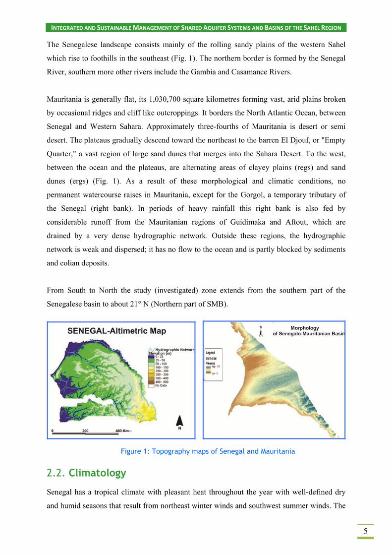
The Senegalese landscape consists mainly of the rolling sandy plains of the western Sahel
which rise to foothills in the southeast (Fig. 1). The northern border is formed by the Senegal
River, southern more other rivers include the Gambia and Casamance Rivers.
Mauritania is generally flat, its 1,030,700 square kilometres forming vast, arid plains broken
by occasional ridges and cliff like outcroppings. It borders the North Atlantic Ocean, between
Senegal and Western Sahara. Approximately three-fourths of Mauritania is desert or semi
desert. The plateaus gradually descend toward the northeast to the barren El Djouf, or "Empty
Quarter," a vast region of large sand dunes that merges into the Sahara Desert. To the west,
between the ocean and the plateaus, are alternating areas of clayey plains (regs) and sand
dunes (ergs) (Fig. 1). As a result of these morphological and climatic conditions, no
permanent watercourse raises in Mauritania, except for the Gorgol, a temporary tributary of
the Senegal (right bank). In periods of heavy rainfall this right bank is also fed by
considerable runoff from the Mauritanian regions of Guidimaka and Aftout, which are
drained by a very dense hydrographic network. Outside these regions, the hydrographic
network is weak and dispersed; it has no flow to the ocean and is partly blocked by sediments
and eolian deposits.
From South to North the study (investigated) zone extends from the southern part of the
Senegalese basin to about 21° N (Northern part of SMB).
Figure 1: Topography maps of Senegal and Mauritania
2.2. Climatology
Senegal has a tropical climate with pleasant heat throughout the year with well-defined dry
and humid seasons that result from northeast winter winds and southwest summer winds. The

INTEGRATED AND SUSTAINABLE MANAGEMENT OF SHARED AQUIFER SYSTEMS AND BASINS OF THE SAHEL REGION
6
dry season (November to April) is dominated by hot, dry, Harmattan wind. Dakar's annual
rainfall of about 600 mm occurs between June and October when maximum temperatures
average 30 °C and minimums 24.2°C; December to February maximum temperatures average
25.7°C and minimums 18°C (64.4 °F). Interior temperatures are higher than along the coast
(for example, average daily temperatures in Kaolack and Tambacounda for May are 30°C and
32.7°C (90.9 F) respectively, compared to Dakar's 23.2°C, and rainfall increases substantially
farther south, exceeding 1,500 mm annually in some areas. The northernmost part of the
country has a near hot desert climate, the central part has a hot semi-arid climate and the
southernmost part has a tropical wet and dry climate (Fig. 2).
In Mauritania, the climate is characterized by extremes in temperature and by meagre and
irregular rainfall. Annual temperature variations are small, although diurnal variations can be
extreme. The harmattan, a hot, dry, and often dust-laden wind, blows from the Sahara
throughout the long dry season and is the prevailing wind, except along the narrow coastal
strip, which is influenced by oceanic trade winds. Mauritania has four ecological zones: the
Saharan Zone, the Sahelian Zone, the Senegal River Valley, and the Coastal Zone. Most rain
falls during the short rainy season (“hivernage”), from July to September, and average annual
precipitation varies from 500 to 600 millimetres in the far south to less than 100 millimetres
in the northern two-thirds of the country.
Figure 2: Senegal and Mauritania climate maps according to Köppen classification (In Madioune et al. 2016 and Upton and Ó Dochartaigh 2016).
The rainfall variability in space and time and climatic parameters are illustrated in Fig. 3.

INTEGRATED AND SUSTAINABLE MANAGEMENT OF SHARED AQUIFER SYSTEMS AND BASINS OF THE SAHEL REGION
7
Figure 3: Meteorological parameters observed at the Rosso, Boutilimit and Bakel stations
2.3. Hydrology
The water resources of the Senegal River Basin (340 000 km2) are shared between Mali,
Senegal and Mauritania. The rainy uplands of Guinea are the source of a major part of the
river water. At the River mouth, close to the city of Saint-Louis, the mean annual flow is
732m3/s, ie a total volume of 23 milliards m3, with large annual fluctuations ranging from 8
to 45 milliards m 3 . Normally the flooding period is situated between July and
October. Then the flow rapidly decreases and become very low (minimum average monthly
discharge of 9 m3/s in May).
A variety of water uses are found on either side of the Valley (Mauritania in the North and
Senegal in the South). Some are traditional and pre-existed the infrastructures. Modern ones
were introduced as part of the overall planning process of water resources development
(commissioning of Manantali and Diama dams).

INTEGRATED AND SUSTAINABLE MANAGEMENT OF SHARED AQUIFER SYSTEMS AND BASINS OF THE SAHEL REGION
8
In Mauritania, the renewable surface water resources are estimated to be about 11 km3/yr,
mainly provided by the Senegal River, and by smal l dams located in the Southern and
Central part of the territory. At the beginning of the twenties, the extracted water volume was
estimated at about 1 700 M m3 (88% irrigation, 9% for domestic use and 3% for industrial
activities).
On the Senegal side, the Senegal River supply the Guiers lake which can store about 500 M
m3 and provide about 120 000 m3/y for Dakar Water supply. The alluvial aquifers are partly
made of clay and fine sands, which represent the Post Nouakchottian deposits, and also coarse
and gravelly alluvium, clayey sand dated from the Ogolian period and the old and middle
Quaternary. The alluvial aquifer is the principal bed of the river and its water flow varies with
the high and low flow stages of the river.
The history of groundwater development/evaluation in the Senegal River Basin could be
summarized in two periods, before and after commissioning of the dams (Fig. 4). During the
early stages of the development of the valley different localized investigations have been
carried out to characterize the hydrodynamics functioning and the recharge mode of the
alluvial aquifer in the valley. The pre-dam situation has been established for the delta
(Audibert, 1970) and for the valley (BRGM, 1964 et 1965; IRAT, 1965 et 1967; Illy, 1973,
Saos et al., 1984), indicating some complex relationship between the Senegal River and the
aquifer system.
Subsequent investigations carried out during the post-dam period (Bonkel, 1989;
USAID/OMVS, 1990, EQUESEN, 1990/1991, Diao. 1992; Diagana, 1994, Dieng, 1997,
Touzi, 1998, Diaw, 2008) have confirmed this inter-relationship and shed some light on the
possible impacts and management issues of surface water resources influencing groundwater
and its sensitivity to the changing climate conditions.

INTEGRATED AND SUSTAINABLE MANAGEMENT OF SHARED AQUIFER SYSTEMS AND BASINS OF THE SAHEL REGION
9
Figure 4: Evolution of the Senegal River before and after the Diama Dam building (1989) (In Mohamed, 2012)
2.4. Vegetation types, land use
In the year 2000, Senegal’s savannas, woodlands, and forests still cover more than two-thirds
of the country (Fig.5)
Figure 5: Vegetation and land use in the Senegalese part of the Basin (Land use/Land cover of West Africa, USGS; In Madioune et al., 2016)
In Mauritania, belts of natural vegetation, corresponding to the rainfall pattern, extend from
East to West and range from traces of tropical forest along the Senegal River to brush and
savannah in the southeast. Only sandy desert is found in the Centre and North of the country.

INTEGRATED AND SUSTAINABLE MANAGEMENT OF SHARED AQUIFER SYSTEMS AND BASINS OF THE SAHEL REGION
10
Sandy surfaces increased from about 46,000 km2 to about 64,000 km2 over Mauritania's
Sahelian and Saharan-Sahelian regions (over 37 percent increase). Severe drought in the
1970s and 1980s played a major role in driving this shift in land cover. Sand dunes and flat
sandy areas previously stabilized by herbaceous and shrub cover have become mobile and
active (Fig.6).
Figure 6: Land use in the Mauritanian part of the Basin (Land use/Land cover of West Africa, USGS 2013)
2.5. Geology and hydrogeology
As indicated above, three main aquifer systems providing exploited ground water resources
can be distinguished in the SMB (Madioune and al., 2016).
1) Shallow aquifer systems (Quaternary and CT) discontinuously cover the whole
sedimentary SMB. It is dominantly made of sand and sandy clay, which vary in proportion
across its extent. The aquifers are intergranular, and the best groundwater potential occurs in
sand layers. It comprises the following aquifers:
INTEGRATED AND SUSTAINABLE MANAGEMENT OF SHARED AQUIFER SYSTEMS AND BASINS OF THE SAHEL REGION
11
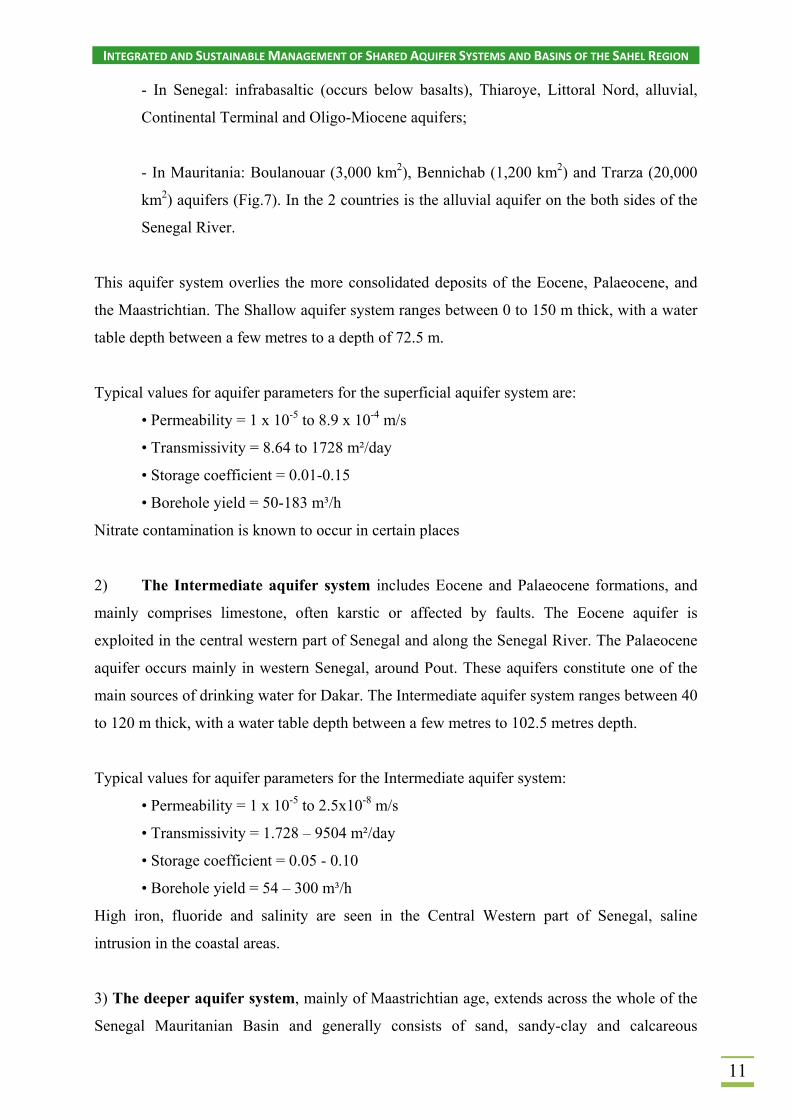
- In Senegal: infrabasaltic (occurs below basalts), Thiaroye, Littoral Nord, alluvial,
Continental Terminal and Oligo-Miocene aquifers;
- In Mauritania: Boulanouar (3,000 km2), Bennichab (1,200 km2) and Trarza (20,000
km2) aquifers (Fig.7). In the 2 countries is the alluvial aquifer on the both sides of the
Senegal River.
This aquifer system overlies the more consolidated deposits of the Eocene, Palaeocene, and
the Maastrichtian. The Shallow aquifer system ranges between 0 to 150 m thick, with a water
table depth between a few metres to a depth of 72.5 m.
Typical values for aquifer parameters for the superficial aquifer system are:
• Permeability = 1 x 10⁻⁵ to 8.9 x 10⁻⁴ m/s
• Transmissivity = 8.64 to 1728 m²/day
• Storage coefficient = 0.01-0.15
• Borehole yield = 50-183 m³/h
Nitrate contamination is known to occur in certain places
2) The Intermediate aquifer system includes Eocene and Palaeocene formations, and
mainly comprises limestone, often karstic or affected by faults. The Eocene aquifer is
exploited in the central western part of Senegal and along the Senegal River. The Palaeocene
aquifer occurs mainly in western Senegal, around Pout. These aquifers constitute one of the
main sources of drinking water for Dakar. The Intermediate aquifer system ranges between 40
to 120 m thick, with a water table depth between a few metres to 102.5 metres depth.
Typical values for aquifer parameters for the Intermediate aquifer system:
• Permeability = 1 x 10⁻⁵ to 2.5x10⁻⁸ m/s
• Transmissivity = 1.728 – 9504 m²/day
• Storage coefficient = 0.05 - 0.10
• Borehole yield = 54 – 300 m³/h
High iron, fluoride and salinity are seen in the Central Western part of Senegal, saline
intrusion in the coastal areas.
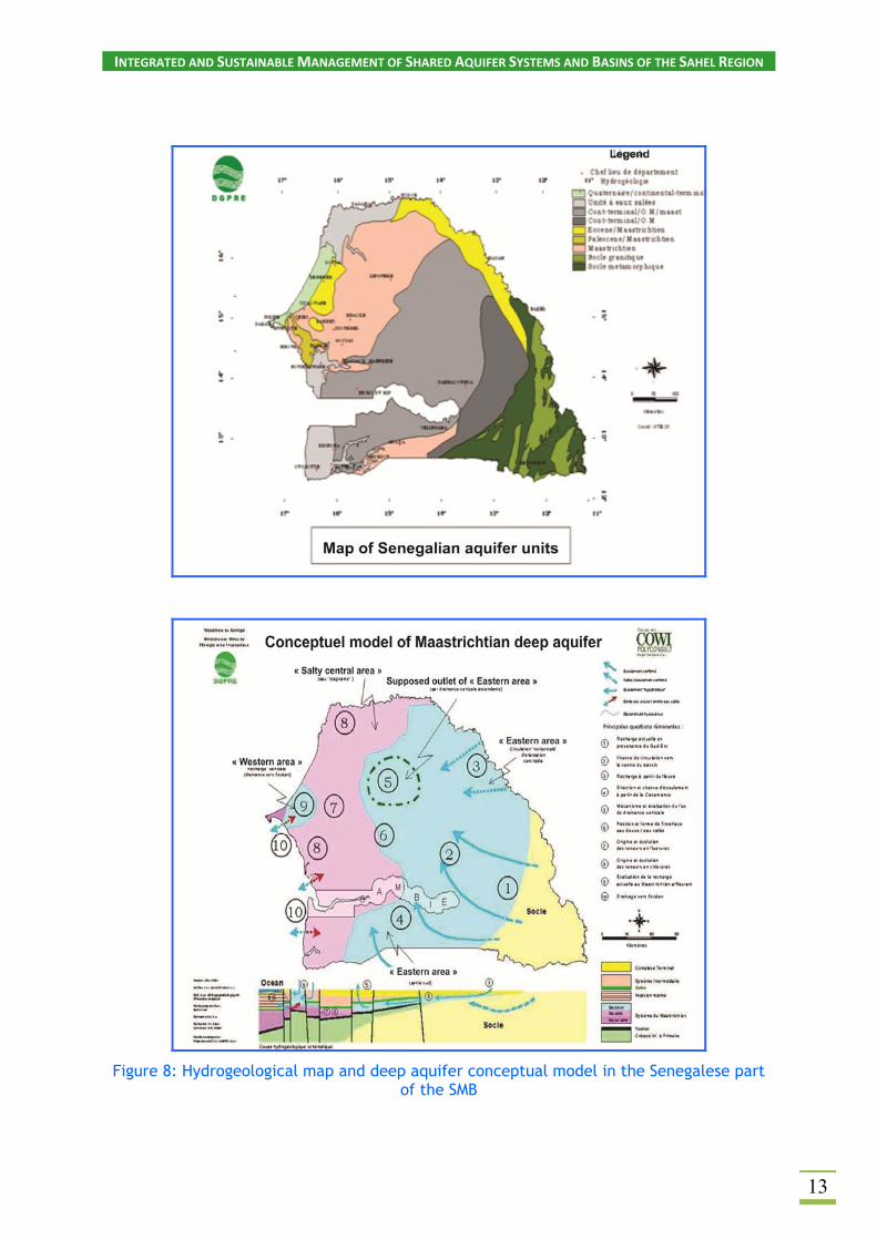
3) The deeper aquifer system, mainly of Maastrichtian age, extends across the whole of the
Senegal Mauritanian Basin and generally consists of sand, sandy-clay and calcareous

INTEGRATED AND SUSTAINABLE MANAGEMENT OF SHARED AQUIFER SYSTEMS AND BASINS OF THE SAHEL REGION
12
sandstone. Groundwater storage and flow are largely intergranular. This aquifer constitutes
the main source of groundwater supply in Senegal. It is a transboundary system but is not
exploited in Mauritania due to low hydraulic conductivity and high salinity. The deeper
aquifer system is about 250 m thick, with a water table depth between a few metres to 140
metres. Typical borehole depth varies between 25 and 680 m. It is typically highly productive,
although aquifer properties vary according to local characteristics (lithology, thickness, etc.)
(Fig.8). Except for the Eastern and Western borders, the aquifer is generally confined.
Typical values for aquifer parameters for the deeper aquifer system are:
• Permeability = 1 x 10⁻⁵ m/s
• Transmissivity = 0.95 – 652578 m²/day
• Storage coefficient = 1 x 10⁻⁴ – 6 x 10⁻⁴ in the Western Central part
• Borehole yield = 80 – 362 m³/h
Recharge occurs from direct rainfall and indirectly from rivers, and is estimated at about 103
x 106 m³/a to the Maastrichtian deeper aquifer system. It is mainly recharged in the Western
part in Diass horst where formations outcrop, and at the contact with the basement formations
and the unconsolidated formations in the South-Eastern part of Senegal.
Figure 7: Hydrogeological map of the Mauritanian part of the SMB and SSW/WNW cross-section
INTEGRATED AND SUSTAINABLE MANAGEMENT OF SHARED AQUIFER SYSTEMS AND BASINS OF THE SAHEL REGION
13
Figure 8: Hydrogeological map and deep aquifer conceptual model in the Senegalese part of the SMB

INTEGRATED AND SUSTAINABLE MANAGEMENT OF SHARED AQUIFER SYSTEMS AND BASINS OF THE SAHEL REGION
14
Groundwater depletion occurs locally due to over abstraction. High iron, fluoride and salinity
are seen in the Central Western part of Senegal. Saline intrusion is observed in the coastal
areas, but high salinity is often attributed to very old sea water (connate water).
2.6. Water supply and water resources management in the
basin
Senegal and Mauritania have significant groundwater resources but the distribution of
availability and demand do not match. This means that some groundwater systems are over
exploited, leading to groundwater depletion: this has been observed in the Palaeocene and
Maastrichtian in the Diass aquifer system. Groundwater and surface water management in
Senegal, including water policy, are the responsibility of the “Direction de la Gestion et de la
Planification des Ressources en Eau (DGPRE)”. Permits are required for drilling and water
abstraction. Currently, there is no legislative protection for groundwater in vulnerable areas,
and water disposal is not controlled. Data show that in 2008 there were at least 7000 recorded
groundwater sources in Senegal, both boreholes and large diameter (hand dug) wells, with
geological log information for about 1400 of the existing boreholes (Table 1). Groundwater
levels are monitored twice a year: before and after the rainy season. This work is funded
through the Ministry of Hydraulics and Sanitation.
Groundwater quality is measured twice per year, before and after the rainy season, funded
by the Ministry of Hydraulics and Sanitation. This work is sometimes extended by NGOs,
researchers or others who want to better understand water quality.
Table 1: Groundwater withdrawal in Senegal. (Source: World Bank)
Annual Freshwater Withdrawal (2013) 2.611 Million m3
Annual Freshwater Withdrawal for Agriculture 92.98%
Annual Freshwater Withdrawal for Domestic Use 4.412%
Annual Freshwater Withdrawal for Industry 2.611%
Rural Population with Access to Improved Water Source 60.3%
Urban Population with Access to Improved Water Source 92.5%
These data are collected and stored by the « Direction de la Gestion et de la Planification des
Ressources en Eau » (DGPRE) and the « Société Nationale des Eaux du Sénégal » (SONES).

INTEGRATED AND SUSTAINABLE MANAGEMENT OF SHARED AQUIFER SYSTEMS AND BASINS OF THE SAHEL REGION
15
In Mauritania, a water point database exists, with entries for nearly 14,000 boreholes and both
traditional and modern wells, but has little supporting information (such as geological logs or
records of groundwater levels). 500 borehole measurements have been provided by SNDE
(“Société Nationale de l’Eau”) in 2005, 400 in Trarza area and 100 in Brakna area (Table 2).
Table 2: Groundwater withdrawal in Mauritania (Source: World Bank)
Annual Freshwater Withdrawal (2013) 1,350 Million m3
Annual Freshwater Withdrawal for Agriculture (2013) 90.6%
Annual Freshwater Withdrawal for Domestic Use (2013) 7.1%
Annual Freshwater Withdrawal for Industry (2013) 2.4%
Rural Population with Access to Improved Water Source (2012) 47.7%
Urban Population with Access to Improved Water Source (2012) 52.3%
3. DATA ACQUISITION AND METHODOLOGY USED
For Mauritania three sampling campaigns have been carried out in 2013, 2014 and 2015.
Samples were collected from Continental Terminal/Quaternary and Eocene aquifers. The
locations of samples are shown in figure 9. A total of 156 groundwater samples, 4 surface
samples and 4 rainfall events (2014 campaign at Nouakchott and Kaedi), has been collected
and adequately conditioned for chemical, stable isotopes and tritium analyses. For such
analyses the samples were sent to the LRAE laboratory of the National Engineer School of
Sfax (ENIS) (Tunisia). Nine samples (2015 campaign) were analysed for 14C in the isotopic
Centre at Groningen).
Data processing has been carried out using the software ArcGis, MapInfo, Diagramme and
Phreeque C; the data of this project have been jointly studied and compared with the former
data of the national IAEA-supported project (MAU/8/002).
INTEGRATED AND SUSTAINABLE MANAGEMENT OF SHARED AQUIFER SYSTEMS AND BASINS OF THE SAHEL REGION
16
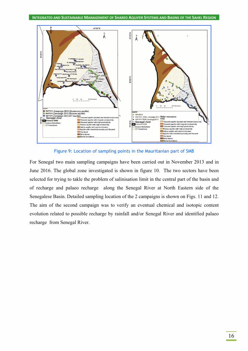
Figure 9: Location of sampling points in the Mauritanian part of SMB
For Senegal two main sampling campaigns have been carried out in November 2013 and in
June 2016. The global zone investigated is shown in figure 10. The two sectors have been
selected for trying to takle the problem of salinisation limit in the central part of the basin and
of recharge and palaeo recharge along the Senegal River at North Eastern side of the
Senegalese Basin. Detailed sampling location of the 2 campaigns is shown on Figs. 11 and 12.
The aim of the second campaign was to verify an eventual chemical and isotopic content
evolution related to possible recharge by rainfall and/or Senegal River and identified palaeo
recharge from Senegal River.

INTEGRATED AND SUSTAINABLE MANAGEMENT OF SHARED AQUIFER SYSTEMS AND BASINS OF THE SAHEL REGION
17
Figure 10: Sampling area in the Senegalese part of the SMB
Figure 11: Sampling points in the Senegalese part of the SMB

INTEGRATED AND SUSTAINABLE MANAGEMENT OF SHARED AQUIFER SYSTEMS AND BASINS OF THE SAHEL REGION
18
Figure 12: Sampling points of the second campaign in the Senegalese part of the SMB
Classical physico chemical parameters (pH, EC and T) were measured in situ. Samples were
prepared for chemical, stable isotope and tritium analyses during the two campaigns, and
carbon-14 analyses during the second campaign. Chemical analyses includes the minor
elements F, Fe (tot) and Br. Trace elements including Li and B have also been analysed for
some samples of the Maastrichtian aquifer, close to the saline limit, for trying to caracterize
connate water. The first campaign samples were sent to the CNESTEN Lab in Rabat
(Morroco), the second one to the LRAE in Sfax (Tunisia). The 14C analyses (26) have been
carried out at the Isotopic Centre, University of Groningen (Nederlands). Data processing has
been carried out using the softwares ArcGis, Diagramme and PhreequeC.

INTEGRATED AND SUSTAINABLE MANAGEMENT OF SHARED AQUIFER SYSTEMS AND BASINS OF THE SAHEL REGION
19
4. RESULTS AND INTERPRETATION
4.1. General chemical and isotopic characterisation
Mauritanian part of the Basin
The distribution of the water points on the Piper diagram (Fig.13) shows mixed sodium-
carbonate waters on the cation side, with a relatively similar evolution for the three aquifer
systems. On the contrary, these aquifer systems are relatively well distinguished on the
anionic side of the diagram. The quaternary points evolved between HCO3- and Cl- end
members and the Eocene water points are more influenced by the SO42-
end member. In the
CT almost all ground water are dominated by Cl- content with a slight influence of SO42-.
Figure 13: Piper Diagram of Mauritanian ground water (first campaign)
Further explanation of chemical processes is necessary considering the samples location and
the flow path directions. Globally quaternary sampling points lie close to the Senegal River,
while CT and Eocene aquifer have been sampled along the River and along lines starting from
the River towards the central part of the Trarza plain.
Calcium and HCO3- evolution clearly indicates saturation with respect to calcite at about 500
mg/L TDS. We may note that Ca increases again especially for Eocene and some Quaternary
samples. Na increases regularly with respect to the TDS evolution, in agreement with what is
observed in the Piper diagram, reflecting more a mixing with sea water or evaporite

INTEGRATED AND SUSTAINABLE MANAGEMENT OF SHARED AQUIFER SYSTEMS AND BASINS OF THE SAHEL REGION
20
dissolution probably enhanced by an evaporative process than a cation exchange process,
(Fig.14).
Figure 14: Relationships between some major elements and TDS (Ca2+, Na+ and HCO3-)
The stable isotope composition of groundwater varies over a relatively wide range, from -6,
5‰ to +1 ‰ for δ18O and -10‰ to -43‰ for δ2H. The stable isotope data presented on the
diagram clearly indicate a significant influence of an evaporative process. This process mainly
affects the ground water of the quaternary aquifer.
The intersect of the evaporation slope with the global meteoric Water line displays a value
about -6,2‰ which seems relatively close to the rainfall input signature as discussed below.
Nevertheless, some Eocene water slightly less depleted and lying close to the Global Meteoric
Water Line could originate from River water.

INTEGRATED AND SUSTAINABLE MANAGEMENT OF SHARED AQUIFER SYSTEMS AND BASINS OF THE SAHEL REGION
21
Figure 15: Stable isotope composition on plot δ18O vs δ2H
Although Fig. 15 clearly indicates a significant influence of evaporative process, the plot Cl-
vs. δ18O (Fig. 16), generally used for characterising salinization processes, does not clearly
indicate a dominant evaporation role. Especially some CT points do not match considering the
two diagrams. This will be discussed more in detail in the salinization paragraph especially
using the Na+/Cl- ratio.
Figure 16: Relationship between δ18O and Cl- contents
Senegalese part of the basin
According to the to the well-known mineralisation process along the flow path (from the
Western recharge zone) in the Maastrichtian aquifer (Travi, 1988; Faye, 1994), the water
points evolve from water Ca2+/ HCO3- dominated towards water Na+/ HCO3
- dominated and
finally Na+/Cl- dominated (Fig. 17).

INTEGRATED AND SUSTAINABLE MANAGEMENT OF SHARED AQUIFER SYSTEMS AND BASINS OF THE SAHEL REGION
22
This chemical evolution reflects the cation exchange process (Ca/Na amplified by calcite
saturation) and the presence of connate water in the western graben zone, where anionic
mineralisation is strongly dominated by Cl-. Some SO42-
water reflects the dissolution of
evaporatic minerals discontinuously present in the Maastrichtian aquifer in the central part of
the basin.
The two plots presented in figure 18, clearly confirm the hydro chemical evolution presented
above, with a regular evolution from the Ca2+/HCO3- type towards the Na+/ HCO3
- type and
the significant shift to NaCl type.
Figure 17: Piper diagram of Senegalese groundwaters (Mainly Maastrichtian aquifer)
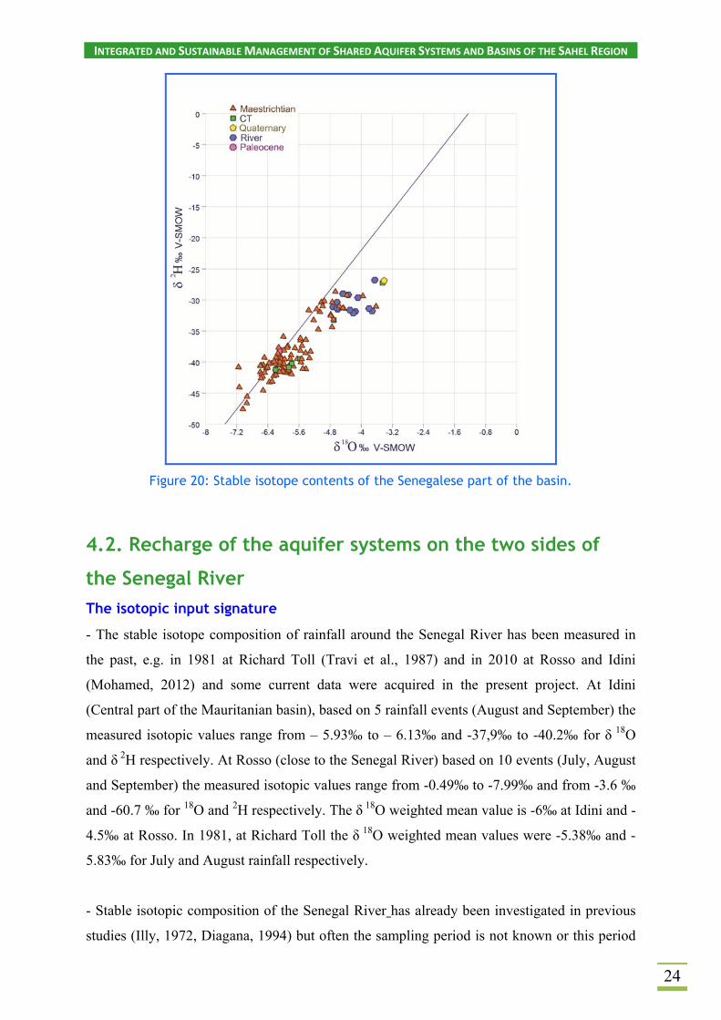
The stable isotope data presented in Figs. 19 and 20 reveals that the δ18O contents vary over a
relative wide range. In addition, Fig. 19 shows a lack of relationship between the two
parameters excluding a significant influence of evaporative process. The more enriched
values corresponding to the eastern and Northern part of the basin seems display the Senegal
River isotopic signature (slightly evaporated) of the flood period (Fig. 20).

INTEGRATED AND SUSTAINABLE MANAGEMENT OF SHARED AQUIFER SYSTEMS AND BASINS OF THE SAHEL REGION
23
Figure 18: Relationship between Ca2+ and HCO3-, and Na+ and Cl-.
Groundwater samples in Central West part of the Basin lie on a trend line below the Meteoric
Water Line, a feature which is typical of old ground water in the Northern part of Africa.
Considering the CT samples position (green points), this graph also strongly suggests a
recharge of the Continental Terminal aquifer by upward leakage from the Maastrichtian
aquifer in the Central part of the basin.
Figure 19: Relationships between δ18O and Cl contents
INTEGRATED AND SUSTAINABLE MANAGEMENT OF SHARED AQUIFER SYSTEMS AND BASINS OF THE SAHEL REGION
24
Figure 20: Stable isotope contents of the Senegalese part of the basin.
4.2. Recharge of the aquifer systems on the two sides of
the Senegal River
The isotopic input signature
- The stable isotope composition of rainfall around the Senegal River has been measured in
the past, e.g. in 1981 at Richard Toll (Travi et al., 1987) and in 2010 at Rosso and Idini
(Mohamed, 2012) and some current data were acquired in the present project. At Idini
(Central part of the Mauritanian basin), based on 5 rainfall events (August and September) the
measured isotopic values range from – 5.93‰ to – 6.13‰ and -37,9‰ to -40.2‰ for δ 18O
and δ 2H respectively. At Rosso (close to the Senegal River) based on 10 events (July, August
and September) the measured isotopic values range from -0.49‰ to -7.99‰ and from -3.6 ‰
and -60.7 ‰ for 18O and 2H respectively. The δ 18O weighted mean value is -6‰ at Idini and -
4.5‰ at Rosso. In 1981, at Richard Toll the δ 18O weighted mean values were -5.38‰ and -
5.83‰ for July and August rainfall respectively.
- Stable isotopic composition of the Senegal River has already been investigated in previous
studies (Illy, 1972, Diagana, 1994) but often the sampling period is not known or this period

INTEGRATED AND SUSTAINABLE MANAGEMENT OF SHARED AQUIFER SYSTEMS AND BASINS OF THE SAHEL REGION
25
is not representative as stable isotope contents display strong variations between dry and wet
season. The aquifers recharge can occur essentially during flooding period. As a consequence,
we only consider the data collected during and just after the rainy season. The Senegalese
staffs involved in the project have sampled the Senegal River in November 2013 and at the
end of June 2016 (see the sampling location in Figs. 11 and 12). The δ18O contents range from
-4.72‰ to -3.34‰, while the δ 2H contents range from 32.1‰ to 22.2‰.
Thus, to investigate possible ground water recharges from rainfall and/or from River Water,
one must consider that rainfall stable isotopic signature is significantly more depleted
compared to Senegal River signature. But we must keep in mind that paleo River water also
could be more depleted compared to the present values, reflecting changes in the isotopic
signature of regional rainfall during the late Pleistocene and early Holocene.
Tritium values have also been measured in the framework of the project. The tritium content
of the Senegal River water sampled at the North east of Senegal basin ranges from 3.2 to
3.4 TU. Rainfall water collected at Kaedi in the same area varies between 2.7 and 6.3 TU.
Groundwater recharge on the Senegalese side of the Senegal River
If we exclude samples close to the Senegal River and the B-202 and B-040 samples, stable
isotope signature does not correspond to the present signature of the Senegal River. It is worth
noting that even the sample B-051 of actual age displays a present-day rainfall signature. The
two samples B-202 and B-040 are of actual age. Their most enriched stable isotopic signature
could be interpreted as a recent recharge from the “Lac de Guiers” probably enhanced since
the commissioning of the Diama dam. This is also supported by a slight evaporated signature
(Fig.21).
At the annual scale, no significant changes can be observed between the first sampling
(November 2013) and the second sampling (June 2016) suggesting that the Senegal River
does not supply significantly the Maastrichtian aquifer in this area (Fig.21).

INTEGRATED AND SUSTAINABLE MANAGEMENT OF SHARED AQUIFER SYSTEMS AND BASINS OF THE SAHEL REGION
26
-80
-60
-40
-20
0
20
40
-10 -8 -6 -4 -2 0
18O (permil)
2 H (
per
mil
)
Senegal
Figure 21: Spatial distribution of the δ18O contents (campaign 1) and plot of δ18O vs δ2H for the 2nd campaign (North eastern side).
The interpretation of 14C activities (Fontes & Garnier model) clearly indicates that almost all
groundwater samples refer to Late Pleistocene recharge (transit time between 20,000 and
35,000 years) and a flow direction toward the North West. Holocene recharge from the
Senegal River in 2 places, formerly suggested (Travi, 1988) probably exists, if we consider
the age estimation of the first points of two profiles (13,000 and 18,000 years) which could
correspond to a mixing between Pleistocene and more recent groundwater. The tritium
contents, under the detection values, suggest a Holocene recharge, as observed in the Western
border of the basin, in the “Horst de Ndiass” area” (Travi, 1988). Nevertheless this
INTEGRATED AND SUSTAINABLE MANAGEMENT OF SHARED AQUIFER SYSTEMS AND BASINS OF THE SAHEL REGION
27
contribution is relatively few and the groundwater flow is mainly driven by the recharge in
the South east along the “Senegal oriental” basement rocks.
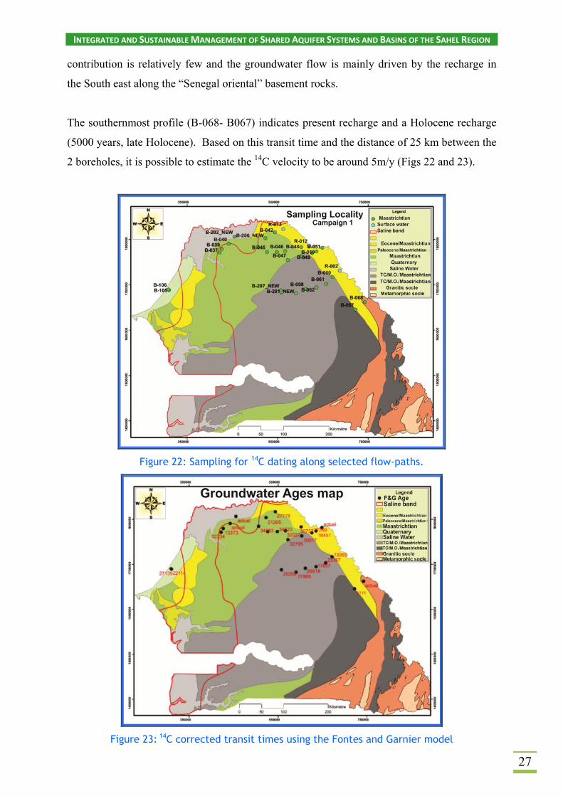
The southernmost profile (B-068- B067) indicates present recharge and a Holocene recharge
(5000 years, late Holocene). Based on this transit time and the distance of 25 km between the
2 boreholes, it is possible to estimate the 14C velocity to be around 5m/y (Figs 22 and 23).
Figure 22: Sampling for 14C dating along selected flow-paths.
Figure 23: 14C corrected transit times using the Fontes and Garnier model

INTEGRATED AND SUSTAINABLE MANAGEMENT OF SHARED AQUIFER SYSTEMS AND BASINS OF THE SAHEL REGION
28
Recharge on the Mauritanian side of the Senegal River
Stable isotopes show a large heterogeneity (Fig.15) and all the quaternary samples show more
or less evaporated water. Some of CT and Eocene groundwater also display evaporative
signature. This indicates infiltration from surface water (oued, lake, small senegal River
tributaries or ponds).
Two evaporation lines seems to be distinguished and the stable isotope values observed on the
plot 18O vs 2H allow, especially for the Eocene aquifer, two input signature to be considered.
This suggest that all the groundwater could originate from rainfall or Senegal River. This is
supported by the tritium contents which show an irregular decrease from the River towards
the centre of the basin (Fig. 24). It is note worthing that the Quaternary aquifer and a part of
the CT aquifer are recharged by present day rain fall or River water (Fig. 25). On the contrary,
the deeper aquifer systems (CT and Eocene) are recharged by more ancient water. A rough
calculation, using a “piston flow” model indicates that 44% of CT groundwater and 40% of
Eocene groundwater have been recharged before 1961, while all the shallow groundwater
(mainly Quaternary Aquifer) are later than 1961.
Figure 24: Tritium content evolution in the Mauritanian part of the SMB

INTEGRATED AND SUSTAINABLE MANAGEMENT OF SHARED AQUIFER SYSTEMS AND BASINS OF THE SAHEL REGION
29
Figure 25: Tritium content vs groundwater depth
Nine radiocarbon measurements have been carried out. They give values between 56 and 76%
modern carbon for CT and Quaternary aquifers (6 samples) and 25 and 52% modern carbon
for Eocene aquifer (3 samples) and δ13C values clearly indicate that carbon dilution has
occurred. Corrected carbon activities, using the Fontes and Garnier model which seems the
most adequate in these aquifer systems, indicate recent recharge except for 2 Eocene aquifer
samples. Estimated groudnwater ages for these two samples are >100 yr and about 2,800 yr,
showing that some ancient groundwater lies in the deeper part of the Eocene aquifer,
recharged during the late Holocene humid period.
An attempt for calculating a recharge rate is by using the simple formula: recharge rate =
porosity x depth / age. In this case, the formula provides very low values of recharge,which is
consistent with other estimates; about 5% of the annual precipitation, Mohamed (2012), using
water balance considerations and hydrodynamic approaches. This finding supports the
hypothesis that an important source of the aquifer recharges is lateral infiltration from the
Senegal River.

INTEGRATED AND SUSTAINABLE MANAGEMENT OF SHARED AQUIFER SYSTEMS AND BASINS OF THE SAHEL REGION
30
4.3. Salinization: general processes and location of the limit in the Maastrichtian aquifer
The plot δ18O vs EC (Fig. 26) confirms the relatively large range of 18O values in the Central
part of the aquifer, already observed before (Figs 19 and 20). In addition, the d-excess
signature confirms the presence of very old groundwater. It may be noted that the stable
isotope contents are relatively enriched compared with values observed in deep groundwaters
of the eastern continental basins. This could be due to the proximity of the Atlantic Ocean and
locally, to a possible mixing with connate water induced by excessive withdrawal.
Figure 26: Plot of δ18O vs EC in the Maastrichtian aquifer
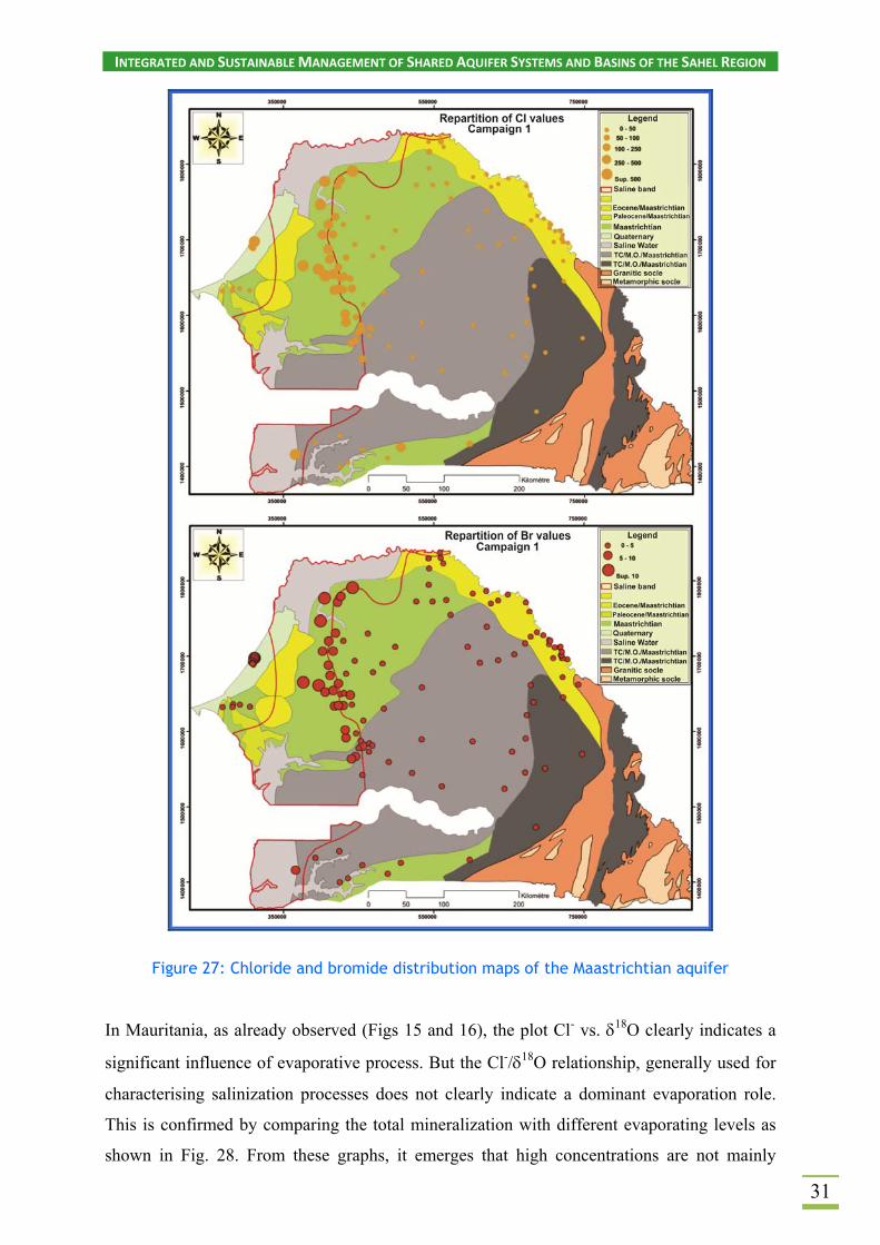
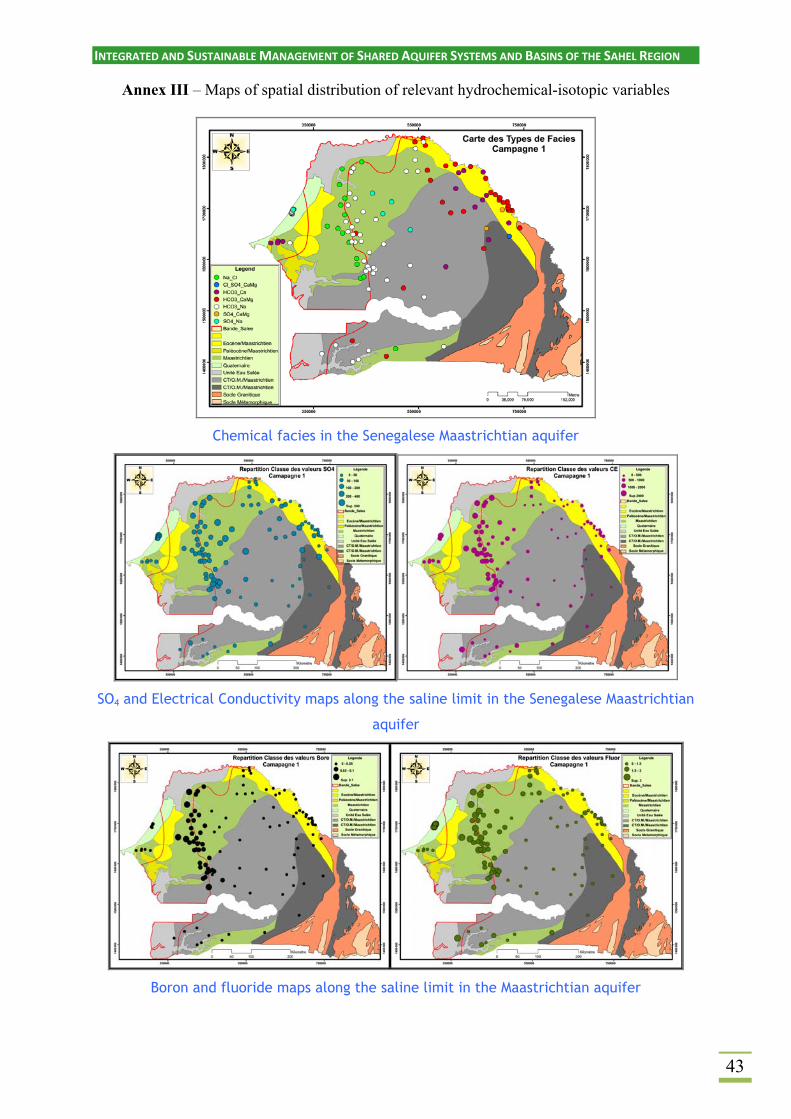
Mapping of the new chemical data allows the limits of the western saline zone to be more
clearly defined. However, Fig. 27 clearly demonstrate that the limit could be better defined
and drawn using mainly chloride and bromide. Finally, boron and fluoride contents, often
considered as good indicators, seem to be more associated, in this case, to marine clays
sediments than the presence of saline groundwater (see map in Annex III).
INTEGRATED AND SUSTAINABLE MANAGEMENT OF SHARED AQUIFER SYSTEMS AND BASINS OF THE SAHEL REGION
31
Figure 27: Chloride and bromide distribution maps of the Maastrichtian aquifer
In Mauritania, as already observed (Figs 15 and 16), the plot Cl- vs. 18O clearly indicates a
significant influence of evaporative process. But the Cl-/18O relationship, generally used for
characterising salinization processes does not clearly indicate a dominant evaporation role.
This is confirmed by comparing the total mineralization with different evaporating levels as
shown in Fig. 28. From these graphs, it emerges that high concentrations are not mainly
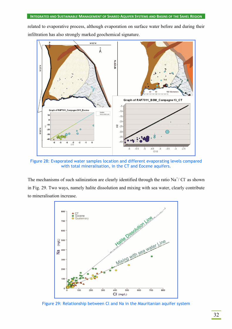
INTEGRATED AND SUSTAINABLE MANAGEMENT OF SHARED AQUIFER SYSTEMS AND BASINS OF THE SAHEL REGION
32
related to evaporative process, although evaporation on surface water before and during their
infiltration has also strongly marked geochemical signature.
Figure 28: Evaporated water samples location and different evaporating levels compared with total mineralisation, in the CT and Eocene aquifers.
The mechanisms of such salinization are clearly identified through the ratio Na+/ Cl- as shown
in Fig. 29. Two ways, namely halite dissolution and mixing with sea water, clearly contribute
to mineralisation increase.
Figure 29: Relationship between Cl and Na in the Mauritanian aquifer system

INTEGRATED AND SUSTAINABLE MANAGEMENT OF SHARED AQUIFER SYSTEMS AND BASINS OF THE SAHEL REGION
33
In Mauritania, it is well known that groundwater quality is largely influenced by the residues
of Quaternary transgressions. However, in the Eocene aquifer it is mainly due to dissolution
of salt deposits rather than mixing with salt water. Thus, in the Quaternary and CT aquifer
systems mixing with sea water is the dominant process, locally enhanced by evaporation. It is
worth noting that such a mixing could regularly occur during marine intrusion along the
Senegal River and its tributaries. This phenomenon has continued up to the present time and
has probably been stopped by the Diama dam construction.

INTEGRATED AND SUSTAINABLE MANAGEMENT OF SHARED AQUIFER SYSTEMS AND BASINS OF THE SAHEL REGION
34
The two main themes addressed by the project were “recharge and salinization”. The major
findings provided by field and laboratory investigations using chemical and isotopic
approaches, as well as interpretations described in this report, could be summarized as follow:
- New major information on recharge and palaeorecharge as well ground water flow in
the Eastern and North Eastern part of the Maastrichtian aquifer, southern side of the
Senegal River (Senegal). Despite a slight contribution during the late Holocene the
Senegal River does not provide a significant recharge.
- New information on conditions and mechanisms of recharge in the shallower
aquifers (Quaternary, CT and Eocene) Northern side of the Senegal River
(Mauritania). Vertical recharge from rain fall and lateral from Senegal River are
clearly differentiated.
- New information on the geographical limit of saline ground water in the Central part
of the Maastrichtian Aquifer in Senegal, which has better been defined using Cl and
Br-tracers. The connate origin of the salinization process is strongly suspected, but
need to be more investigated.
- The two main ways of mineralization, namely evaporate dissolution and mixing with
sea water, are clearly identified. Evaporation significantly enhances the process.
Equally important, the project allowed the chemical and isotopic database in Senegal and
Mauritania to be significantly confirmed and completed. In Senegal, significant amount of
isotopic data was already available, but the new investigation has covered two areas relatively
poorly known:
i) At the East and North East of the basin, ground water of Late Pleistocene age have
been identified proving the major role of rainfall recharge at the far South East limit of
the basin, along the basement rocks boundary. Carbon-14 data also suggests a very
limited recharge from the Senegal River (probably a slight contribution during the late
Holocene);
5. CONCLUSIONS

INTEGRATED AND SUSTAINABLE MANAGEMENT OF SHARED AQUIFER SYSTEMS AND BASINS OF THE SAHEL REGION
35
ii) In the Centre West of the basin the saline limit has been clearly defined using Cl
and Br tracing. Boron and Fluoride, which display significant concentrations in this
area, are not directly linked to saline water but most probably to be related to the
nature of the reservoir (marine clays).
In Mauritania, chemical and isotopic data are scarcer and the project allowed the density of
the network, especially in the Trarza and Brakna aquifer systems to be expanded. Then, the
knowledge base has been significantly improved in terms of recharge and salinization
processes:
- i) Quaternary aquifer and a part of the CT aquifer are recharged from present day
rainfall or from Senegal River. The deeper aquifer systems show relatively more
ancient water and late Holocene water have been identified in the Eocene aquifer.
Stable isotopes and radioisotopes suggested the predominant role of the Senegal River
in affecting recharge.
- ii) Stable isotope data and chemical bivariate plots clearly indicated that the
mineralization increase mainly originates from evaporates dissolution and/or mixing
with sea water, often linked to Quaternary marine invasion. The important evaporative
effect on surface water before and during their infiltration has a strongly marked
geochemical signature.
Recommendations In Senegal, expanding knowledge of the Maastricthian aquifer is the main challenge for water
supply in the future. Its exploitation is significantly increasing without a sound management
plan as available studies are relatively scattered and only give aquifer capacities in localized
zones. There is an urgent need for modelling this aquifer as a whole, considering
palaeohydrological aspects, to assure a suitable groundwater management in the future.
The IAEA-supported project RAF/7/011 project made a significant contribution, but to
achieve this goal some complementary information is needed:
-Reliable information on the present-day aquifer recharge in the Northern limit around
the “Lac de Guiers”, and in the Southern limit in Guinea Bissau.

INTEGRATED AND SUSTAINABLE MANAGEMENT OF SHARED AQUIFER SYSTEMS AND BASINS OF THE SAHEL REGION
36
-Exact nature and evolution of the Central West saline zone.
-Some complementary palaeohydrological information in the Central zone.
For this purpose, the following recommendations are suggested:
- Classical isotope methods (stable isotope, tritium and 14C) should continue to be used
for recharge problem around the “Lac de Guiers”. This requires installing a
piezometric network around the Lake, and to establish one (or two, if possible)
sampling station on the Senegal River (IAEA GNIR Network?) for a better knowledge
of the River isotopic signature.
- The Central zone should be more investigated using other radio isotopes which allow
longer transit time to be determined as well as chemical trace elements (Bore and Lithium
seems to be good indicators of the presence of connate water and could be more used to
study upward leakage from the deep part of the system). Nevertheless, such studies should
benefit from the new overall synthesis of all isotopic data provided, and often partially
interpreted, through the numerous IAEA- supported projects and academic works.
- Finally, collaboration should be initiated with the Guinea Bissau Water Authorities in
order to investigate (stable and radio isotopes) the Southernmost recharge zone of the
Maastrichtian aquifer.
In Mauritania, quantification of the available resources of the Trarza and Brakna aquifers is
fundamental requirement for ensuring a sustainable water supply. This implies modelling
these aquifers after improving the knowledge of the recharge and the extension of saline
water.
As for Senegal, the IAEA-supported project RAF/7/011 made a significant contribution to
this purpose. It is recommended to continue the isotopic investigations, but only if such a
study is associated with a reliable piezometric network since the maximum benefit will be
gained when simultaneous isotope, geochemical and hydrodynamic data are incorporated.
Before starting new projects in the two countries a global assessment of groundwater resource
is strongly recommended using the IWAVE approach.

INTEGRATED AND SUSTAINABLE MANAGEMENT OF SHARED AQUIFER SYSTEMS AND BASINS OF THE SAHEL REGION
37
6. REFERENCES
Audibert M. (1970) : Delta du fleuve Sénégal : Etude hydrogéologique. Projet hydroagricole du bassin du fleuve Sénégal. Tome III : Hydrogéologie. Tome IV : drainabilité, rapport projet AFR/REG-61. FAO/OERS. Bellion Y. (1987). Histoire géodynamique post-paléozoïque de l'Afrique de l'Ouest d'après l'étude de quelques bassins sédimentaires (Sénégal, Taoudéni, Iullemmeden, Tchad). Thèse d'Etat sciences : Univ. d’Avignon et des pays du Vaucluse, 296 p., 126 Fig. et 213 Tab. Bonkel A., 1989 : Etude de la répartition des paramètres hydrochimiques des eaux souterraines de l’aquifère alluvial situé en rive droite du fleuve Sénégal entre Keur-Macène et Dagana. Mémoire IST, UCAD, Dakar. Diao S.M., 1992. - Etude des aquifères alluviaux de la vallée du fleuve Sénégal (Secteur Rosso - Dagana - Lac de Guiers) rapport de DEA Dépt. Géol., Fac. Sci.,Univ. C.ADIOP de Dakar 71 p. Diagana A., 1994 : Etudes hydrogéologiques dans la vallée du fleuve Sénégal de Bakel à Podor : Relations eaux de surface/eaux souterraines. Thèse Doctorat 3ème cycle. FST-UCAD, 127p. et annexes. Diaw M. (2008) Approche hydrochimique et isotopique de la relation eau de surface / nappe et du mode de recharge dans l'estuaire et la basse vallée du fleuve Sénégal, Thèse 3éme cycle, Université de Dakar. 210 p. Dieng B., 1987 : Paléo hydrologie et hydrogéologie quantitative du Sénégal. Essai d’application des anomalies observées. Thèse Ecole des Mines de Paris, 168 p. EQUESEN (1993). Environnement et qualité des eaux souterraines. Projet CEE TS 20198 F EDB - Rapport de synthèse Tome 4. Faye A. (1983). Contribution à l'étude géologique et hydrogéologique du horst de Ndiass et de ses environs (Sénégal occidental). Thèse 3eme cycle Univ. Dakar. 160p, 74fig, 10 tab. Faye A. (1994). Recharge et paléo recharge des aquifères profonds du bassin du Sénégal. Apport des isotopes stables et radioactifs de l’environnement et implication paléo hydrologique et paléo climatique. Thèse Doc. ès-Sciences, Université de Dakar, 185p. Faye S. (2005). Apport des outils géochimiques et isotopiques à l’identification des sources de salinité et à l’évaluation du régime d’écoulement de la nappe du Saloum. Thèse de Doctorat d’Etat, és Sciences, Université Cheik Anta Diop, Dakar, p. Gaye CB. (1980). Etude hydrogéologique hydrochimiques et isotopique de la nappe aquifère infra basaltique de la presqu'île du Cap-Vert (Sénégal). Thèse de 3éme cycle UCAD, 1980; 131p. Gaye CB. (1990). Etude isotopique et géochimique du mode de recharge par les pluies, et de décharge évaporatoire des aquifères libres, sous climat semi – aride au nord du Sénégal. Thèse de doctorat d'état Dépt. Géol., Fac. Sci. Univ. C.ADIOP, Dakar, 243 p. Illy P., 1973 : Etude Hydrogéologique de la Vallée du fleuve Sénégal. Projet hydro agricole du bassin du fleuve Sénégal. Rapport 65061, Dakar, OMVS, 58 p. Madioune, D.H., 2012. Etude hydrogéologique du système aquifère du horst de Diass en condition d’exploitation intensive (bassin sédimentaire sénégalais): apport des techniques de télédétection,

INTEGRATED AND SUSTAINABLE MANAGEMENT OF SHARED AQUIFER SYSTEMS AND BASINS OF THE SAHEL REGION
38
modélisation, géochimie et isotopie. Thèse de doctorat en sciences de l’Ingénieur/Université de Liège/Faculté des Sciences Appliquées, 325p. Madioune D.H., Mall I., Faye S., Crane E., Upton K., Ó Dochartaigh B.É. (2016). Africa Groundwater Atlas. Hydrogeology of Senegal. Mohamed A.S. (2012): Approches hydrodynamiques et géochimique de la recharge de la nappe du Trarza, Sud-ouest de la Mauritanie. Thèse IRD/Université Paris Sud, 148 p. et annexes. OMVS/USAID, 1990: Rapport de synthèse hydrogéologique du delta du fleuve Sénégal. Projet OMVS/USAID 625-0958. Eaux souterraines. Rapport final. Dakar, Sénégal. Volume II, p. 63 et Annexes. Saos J.L., Kane A., Carn M., Gac J.Y. (1984). Persistance de la sécheresse au Sahel : invasion marine exceptionnelle dans la vallée du Fleuve Sénégal. 10 ème réunion annuelle Sci. Terre, Bordeaux, p. 499. Sarr, B. (2000). Contribution à l’étude hydrogéologique des aquifères de l’Ouest du bassin du Sénégal. Thèse Docteur 3éme cycle. Fac Sci. UCAD, 128p + annexes. Semega B.M. (1999). Interaction physico-chimiques des eaux de la nappe côtière du Trarza à Idini et long du littoral sud (Thèse de doctorat). Université de Nice-Sophia Antipolis, 235 p. Upton K., Ó Dochartaigh B.É. (2016). Africa Groundwater Atlas. Hydrogeology of Mauritania. Touzi S. (1998). Formalisation des échanges fleuve-nappe en présence de zones d’inondation : Cas de la de la régularisation des crues du fleuve Sénégal. Mém. DEA « Sci. de l’Eau dans l’Environnement Continental », ENGREF, paris, 100 p. Travi Y., Gac J. Y., Fontes J. C., Fritz B., 1987 : Reconnaissance chimique et isotopique des eaux de pluie au Sénégal. Géodynamique, 2 (1), 43-53. Travi Y., 1988: Hydrogéologie et Hydrochimie des aquifères fluorés du Bassin du Sénégal. Origine et conditions de transport du fluor dans les eaux souterraines. Doctorat ès Sciences thesis. Paris Sud University, 190 p. « Hydrogéologie et Hydrochimie des aquifères du Sénégal, Hydrogéochimie du fluor dans les eaux souterraines », Mém. Sci. Géol., N°95, 1993, 155p.

INTEGRATED AND SUSTAINABLE MANAGEMENT OF SHARED AQUIFER SYSTEMS AND BASINS OF THE SAHEL REGION
39
ACRONYMS
CT: Continental Terminal
EC: Electrical Conductivity
ENIS: National Engineer School of Sfax
GNIR: Global Network of Isotopes in Rivers
IAEA: International Atomic Energy Agency
MAU: Mauritania
Q: Quaternary
SMB: Senegalo-Mauritanian Basin
TDS: Total dissolved salts
DGPRE : Direction de la Gestion et de la Planification des Ressources en Eau (DGPRE)
INTEGRATED AND SUSTAINABLE MANAGEMENT OF SHARED AQUIFER SYSTEMS AND BASINS OF THE SAHEL REGION
40
ANNEXES

INTEGRATED AND SUSTAINABLE MANAGEMENT OF SHARED AQUIFER SYSTEMS AND BASINS OF THE SAHEL REGION
41
Annex I - Field, hydrochemical and isotope data generated in the framework of the IAEA-supported project RAF/7/011. A template with all the
analytical results is separately provided
Annex II - 14C-derived transit time calculation for the North Eastern part of the Senegalese Basin (Diagramme software) Nom T°C pH TAC
(meq/l)
A14C Erreur 13C 13C A14C Matrice brut Tamers Pearson Mook F & G AIEA Evans Olive eg_c d13Ceq
13C A14C
B037 36,1 7,79 6,00 1,27 0,3 -11,250 -19 100 0 0 36095 30622 31762 35480 32334 35416 31291 29228 -8,9 -17,80 -12,49
B039 34,7 7,62 3,80 8,86 0,3 -8,590 -19 100 0 0 20036 14681 13473 17815 13373 17223 12667 13042 -9,1 -15,15 -12,46
B040 34,2 6,94 4,30 9,47 0,3 -2,040 -19 100 0 0 19486 15191 1038 9404 actuel 4822 actuel 11147 -9,1 -7,50 -13,54
B042 35,3 7,96 4,55 2,68 0,3 -12,870 -19 100 0 0 29921 24368 26701 30215 27778 30409 26387 23139 -9,0 -19,58 -12,35
B044 36,8 7,41 4,05 1,16 -12,990 -19 100 0 0 36844 31690 33700 36954 34623 37307 33379 29623 -8,8 -19,15 -12,85
B045 36,9 7,54 4,50 1,24 -13,620 -19 100 0 0 36293 31001 33541 36759 34655 37141 33266 29228 -8,8 -19,91 -12,73
B046 36,4 7,62 4,50 1,35 -11,490 -19 100 0 0 35590 30231 31432 35039 32027 35066 30981 28600 -8,9 -17,90 -12,62
B047 36,9 7,2 4,30 1,38 -12,690 -19 100 0 0 35408 30556 32072 35230 32795 35672 31725 27824 -8,8 -18,54 -13,16
B048 35,9 7,42 3,90 1,62 -11,780 -19 100 0 0 34083 28920 30131 33618 30737 33798 29716 26872 -8,9 -18,04 -12,76
B049 37,4 7,41 5,05 0,94 -5,250 -19 100 0 0 38582 33427 27949 33583 27269 31516 25895 31363 -8,8 -11,36 -12,91
B050 33,8 6,94 3,6 4,52 -8,230 -19 100 0 0 25600 21308 18683 22429 18451 22496 17839 17256 -9,2 -13,72 -13,51
B051 32,1 6,14 0,55 84,6 -4,110 -19 100 0 0 1386 actuel actuel actuel actuel actuel actuel actuel -9,4 -6,37 -16,74
B060 36,1 7,24 3,9 8,98 -8,450 -19 100 0 0 19925 15010 13226 17301 13065 16880 12351 12419 -8,9 -14,43 -13,03
B061 37,9 6,9 3 3,18 -10,320 -19 100 0 0 28507 24286 23461 26639 23387 26995 22845 20059 -8,7 -15,40 -13,92
B062 37 6,6 2,6 9,18 -7,730 -19 100 0 0 19743 16397 12308 15378 11857 15901 11243 9778 -8,8 -11,85 -14,88
B067 39,3 6,34 2,1 32,6 -11,710 -19 100 0 0 9259 6738 5257 7120 5111 8700 4785 actuel -8,5 -14,64 -16,07
B068 33,1 6,48 2,05 93,6 -12,850 -19 100 0 0 549 actuel actuel actuel actuel 1178 actuel actuel -9,3 -16,65 -15,20

INTEGRATED AND SUSTAINABLE MANAGEMENT OF SHARED AQUIFER SYSTEMS AND BASINS OF THE SAHEL REGION
42
B098 37,3 6,9 3 2,1 -10,320 -19 100 0 0 31937 27720 26892 30081 26818 30465 26288 23483 -8,8 -15,45 -13,88
B105 43 8,11 4,7 0,89 -4,970 -19 100 0 0 39034 33426 27948 34084 27139 31158 25234 32309 -8,1 -10,99 -13,06
B106 42 8,25 5,15 1,37 -4,290 -19 100 0 0 35468 29827 23166 29945 22114 26437 19846 28777 -8,2 -10,44 -12,96
B201 37,4 6,69 2,6 1,97 -11,000 -19 100 0 0 32466 28836 27947 30663 27868 31514 27426 23040 -8,8 -15,44 -14,56
B202 32,4 6,81 4,3 51 -7,800 -19 100 0 0 5562 1626 actuel 1763 actuel 2113 actuel actuel -9,4 -12,98 -13,83
B203 36,9 7,7 3,1 1,27 -13,720 -19 100 0 0 36095 30676 33403 36659 34583 37004 33136 29170 -8,8 -20,14 -12,61
B204 37,4 7,24 3,1 1,88 -12,430 -19 100 0 0 32852 27932 29344 32551 30017 32911 28969 25353 -8,8 -18,30 -13,14
B205 34,3 7,64 4,55 5,49 -12,290 -19 100 0 0 23993 18623 20391 23966 21265 24169 20043 17015 -9,1 -18,91 -12,41
B206 37,4 6,86 3,3 1,8 -11,650 -19 100 0 0 33212 29097 29168 32083 29206 32735 28718 24600 -8,8 -16,65 -14,00
INTEGRATED AND SUSTAINABLE MANAGEMENT OF SHARED AQUIFER SYSTEMS AND BASINS OF THE SAHEL REGION
43
Annex III – Maps of spatial distribution of relevant hydrochemical-isotopic variables
Chemical facies in the Senegalese Maastrichtian aquifer
SO4 and Electrical Conductivity maps along the saline limit in the Senegalese Maastrichtian
aquifer
Boron and fluoride maps along the saline limit in the Maastrichtian aquifer