selected mining districts - utah.gov
TRANSCRIPT


SelectedMining
Districtsof Utah
MISCELLANEOUS PUBLICATION 05-5UTAH GEOLOGICAL SURVEYa division ofUtah Department of Natural Resources
by
Carl L. Ege
2005
ISBN 1-55791-726-4
Headframe of Centennial Eureka mine, Tintic mining district.

STATE OF UTAHJon Huntsman, Jr., Governor
DEPARTMENT OF NATURAL RESOURCESMichael Styler, Executive Director
UTAH GEOLOGICAL SURVEYRichard G. Allis, Director
PUBLICATIONScontact
Natural Resources Map/Bookstore1594 W. North Temple
telephone: 801-537-3320toll-free: 1-888-UTAH MAP
website: http://mapstore.utah.govemail: [email protected]
THE UTAH GEOLOGICAL SURVEYcontact
1594 W. North Temple, Suite 3110Salt Lake City, UT 84116telephone: 801-537-3300
website: http://geology.utah.gov
Although this product represents the work of professional scientists, the Utah Department of Natural Resources, Utah Geological Survey, makes nowarranty, expressed or implied, regarding its suitability for any particular use. The Utah Department of Natural Resources, Utah Geological Sur-vey, shall not be liable under any circumstances for any direct, indirect, special, incidental, or consequential damages with respect to claims by usersof this product.
The Utah Department of Natural Resources receives federal aid and prohibits discrimination on the basis of race, color, sex, age, national origin,or disability. For information or complaints regarding discrimination, contact Executive Director, Utah Department of Natural Resources, 1594West North Temple #3710, Box 145610, Salt Lake City, UT 84116-5610 or Equal Employment Opportunity Commission, 1801 L. Street, NW, Wash-ington DC 20507.
Printed on recycled paper 1/05

CCOONNTTEENNTTSSIntroduction . . . . . . . . . . . . . . . . . . . . . . . . . . . . . . . . . . . . . . . . . . . . . . . . . . . . . . . . . . . . . . . . . . . . . . . . . . . . . . . .1
What is a mining district? . . . . . . . . . . . . . . . . . . . . . . . . . . . . . . . . . . . . . . . . . . . . . . . . . . . . . . . . . . . . . . . . . .1How many mining districts are there in Utah and are they still active . . . . . . . . . . . . . . . . . . . . . . . . . . . . . . . .1What mineral resources are mined in Utah’s most productive mining districts . . . . . . . . . . . . . . . . . . . . . . . . .1What are the most common types of ore deposits found in Utah’s mining districts? . . . . . . . . . . . . . . . . . . . . .1What about landownership and safety issues? . . . . . . . . . . . . . . . . . . . . . . . . . . . . . . . . . . . . . . . . . . . . . . . . . . .2
Selected Mining Districts . . . . . . . . . . . . . . . . . . . . . . . . . . . . . . . . . . . . . . . . . . . . . . . . . . . . . . . . . . . . . . . . . . . . .3Gold Hill (Clifton) . . . . . . . . . . . . . . . . . . . . . . . . . . . . . . . . . . . . . . . . . . . . . . . . . . . . . . . . . . . . . . . . . . . . . . . .3Spor Mountain . . . . . . . . . . . . . . . . . . . . . . . . . . . . . . . . . . . . . . . . . . . . . . . . . . . . . . . . . . . . . . . . . . . . . . . . . . .6Bingham (West Mountain) . . . . . . . . . . . . . . . . . . . . . . . . . . . . . . . . . . . . . . . . . . . . . . . . . . . . . . . . . . . . . . . . . .9Ophir . . . . . . . . . . . . . . . . . . . . . . . . . . . . . . . . . . . . . . . . . . . . . . . . . . . . . . . . . . . . . . . . . . . . . . . . . . . . . . . . .12Mercur (Camp Floyd) . . . . . . . . . . . . . . . . . . . . . . . . . . . . . . . . . . . . . . . . . . . . . . . . . . . . . . . . . . . . . . . . . . . .14Tintic . . . . . . . . . . . . . . . . . . . . . . . . . . . . . . . . . . . . . . . . . . . . . . . . . . . . . . . . . . . . . . . . . . . . . . . . . . . . . . . . .16Mountain Lake . . . . . . . . . . . . . . . . . . . . . . . . . . . . . . . . . . . . . . . . . . . . . . . . . . . . . . . . . . . . . . . . . . . . . . . . . .19
Big Cottonwood . . . . . . . . . . . . . . . . . . . . . . . . . . . . . . . . . . . . . . . . . . . . . . . . . . . . . . . . . . . . . . . . . . . . . .21Little Cottonwood . . . . . . . . . . . . . . . . . . . . . . . . . . . . . . . . . . . . . . . . . . . . . . . . . . . . . . . . . . . . . . . . . . . . .23American Fork . . . . . . . . . . . . . . . . . . . . . . . . . . . . . . . . . . . . . . . . . . . . . . . . . . . . . . . . . . . . . . . . . . . . . . .25
Park City . . . . . . . . . . . . . . . . . . . . . . . . . . . . . . . . . . . . . . . . . . . . . . . . . . . . . . . . . . . . . . . . . . . . . . . . . . . . . .26San Francisco . . . . . . . . . . . . . . . . . . . . . . . . . . . . . . . . . . . . . . . . . . . . . . . . . . . . . . . . . . . . . . . . . . . . . . . . . . .29Iron Springs . . . . . . . . . . . . . . . . . . . . . . . . . . . . . . . . . . . . . . . . . . . . . . . . . . . . . . . . . . . . . . . . . . . . . . . . . . . .31Silver Reef (Harrisburg) . . . . . . . . . . . . . . . . . . . . . . . . . . . . . . . . . . . . . . . . . . . . . . . . . . . . . . . . . . . . . . . . . . .33Principal Uranium Districts . . . . . . . . . . . . . . . . . . . . . . . . . . . . . . . . . . . . . . . . . . . . . . . . . . . . . . . . . . . . . . . .35
White Canyon . . . . . . . . . . . . . . . . . . . . . . . . . . . . . . . . . . . . . . . . . . . . . . . . . . . . . . . . . . . . . . . . . . . . . . . .35Lisbon Valley . . . . . . . . . . . . . . . . . . . . . . . . . . . . . . . . . . . . . . . . . . . . . . . . . . . . . . . . . . . . . . . . . . . . . . . .37
Acknowledgments . . . . . . . . . . . . . . . . . . . . . . . . . . . . . . . . . . . . . . . . . . . . . . . . . . . . . . . . . . . . . . . . . . . . . . . . . .38Selected Bibliography . . . . . . . . . . . . . . . . . . . . . . . . . . . . . . . . . . . . . . . . . . . . . . . . . . . . . . . . . . . . . . . . . . . . . . .39Glossary . . . . . . . . . . . . . . . . . . . . . . . . . . . . . . . . . . . . . . . . . . . . . . . . . . . . . . . . . . . . . . . . . . . . . . . . . . . . . . . . . .43
AAPPPPEENNDDIICCEESSAPPENDIX A Descriptive List of Minerals . . . . . . . . . . . . . . . . . . . . . . . . . . . . . . . . . . . . . . . . . . . . . . . . . . . . .45APPENDIX B Generalized Geologic Time Scale . . . . . . . . . . . . . . . . . . . . . . . . . . . . . . . . . . . . . . . . . . . . . . . . .56APPENDIX C Mineral Resources of the Selected Mining Districts . . . . . . . . . . . . . . . . . . . . . . . . . . . . . . . . . . .57

Delta
Fillmore
Richfield
Salina
Manti
Castle Dale
Moab
Monticello
LoaBeaver
Milford
Parowan
Cedar City
St. George
Panguitch
Kanab
Nephi
Eureka
Price
Duchesne
Park City
Sandy
Provo
Tooele
Bountiful
SALTLAKECITY
BrighamCity
Ogden
Logan
Wendover
Vernal
Santaquin
36
89
40
191
30
16
15
15
84 80
84
80
15
15
80
6
191
191
6
191
10
89
89
50
24
50
6
50
6
40
15
15
70
237
70
70
6
19189
130
666
89
15
15
"PonyExpress"
Road
95
56
21
266
174
Hanksville
Leeds
Lehi
Faust
10 0 10 20 30 40 miles
10 0 10 20 30 40 50 kilometers
STATE OF UTAHN
DAVIS
WEBER
MORGAN
WASATCH
UTAH
SUMMIT
DUCHESNE
CARBON
BOX ELDER
TOOELE
JUAB
MILLARD
SALT
LAKE
EMERY
SANPETE
SEVIER
PIUTEBEAVER
IRON GARFIELD
WAYNE
GRAND
UINTAH
SAN JUAN
KANEWASHINGTON
DAGGETT
CACHE
RICHGreat
Salt
Lake
UtahLake
SevierLake
LakePowell
Rive
r
Gre
enCol
orad
o
River
San JuanRiver
BearLake
Lisbon Valley
White CanyonIron Springs
Silver Reef(Harrisburg)
San Francisco
Spor Mountain
Gold Hill(Clifton)
Bingham(West Mountain)
Ophir
Mercur(Camp Floyd)
Tintic
American ForkLittle Cottonwood
Park City
Big Cottonwood
Location of Selected Mining Districts of Utah

WWhhaatt iiss aa mmiinniinngg ddiissttrriicctt??
A mining district is a collection of mines that havebeen located and worked under specific rules andguidelines created by the miners and mine operators.After the Mining Act of 1872, the federal governmenttook over administration of many of the rules and reg-ulations concerning claim staking, property owner-ship, and mining. Some districts have defined politi-cal boundaries, natural boundaries (rivers or ridgecrests), or no specific boundaries at all. A district cancontain hundreds of mines and can include a variety ofdifferent materials from building stone to metallicresources.
HHooww mmaannyy mmiinniinngg ddiissttrriiccttss aarree tthheerree iinnUUttaahh aanndd aarree tthheeyy ssttiillll aaccttiivvee??
Utah has over 150 mining districts. These dis-tricts are in a variety of geographic areas, from themountains of the Wasatch to the deserts of the GreatBasin. Today, many of these districts are inactive, butthey could become active again if mining occurs onany of the properties within the district. Many of thedistricts described here are considered active. The 15
districts in this booklet were selected because theyhave been the most productive districts in Utah.
WWhhaatt mmiinneerraall rreessoouurrcceess aarree mmiinneedd iinn UUttaahh’’ssmmoosstt pprroodduuccttiivvee mmiinniinngg ddiissttrriiccttss??
Economically, the most important mineral re-sources mined in Utah are copper, gold, silver, lead,zinc, and iron. Other mineral resources mined includeberyllium, fluorspar, uranium, vanadium, molybde-num, manganese, tungsten, antimony, bismuth, cobalt,arsenic, and mercury (see appendix C for more infor-mation).
WWhhaatt aarree tthhee mmoosstt ccoommmmoonn ttyyppeess ooff oorree ddee--ppoossiittss ffoouunndd iinn UUttaahh’’ss mmiinniinngg ddiissttrriiccttss??
The most common types of ore deposits found inUtah’s mining districts include (1) bedded replace-ment deposits, (2) vein or fissure deposits, and (3)skarn deposits. These deposits are found in many ofthe mining districts throughout the state and representsome of the most productive deposits for their miner-al value.
INTRUSIVE
IGNEOUS
ROCK
FAU
LT
FAULT
Bedded replacementdeposit in limestone
Skarn deposits inlimestone
Vein or fissure depositin igneous rock
Most Common Types of Ore Deposits in Utah’s Mining Districts
IINNTTRROODDUUCCTTIIOONNWhether you are a geologist, history buff, or rockhound, this booklet will be a helpful
guide to Utah’s mining districts. The booklet is divided up into three parts: the first part pro-vides general information on what a mining district is, how many mining districts are in Utah,types of mineral deposits found at these districts, and landownership issues. The second partincludes individual mining-district discussions containing information on location, produc-tion, history, geology, mineralogy, and current/future operations. The third part includes aglossary of geologic terms and other useful resources in the appendices, such as a descriptivelist of minerals found in the districts, geologic time scale, and a list of mineral resources of themining districts.

Bedded replacement ore deposits result when ris-ing hydrothermal (hot) fluids from a cooling magmabody come into contact with favorable carbonaterocks, such as limestone or dolomite. These fluids aregenerally rich in dissolved metals (gold, silver, lead,copper, or iron) and move upward along breaks orfaults in the Earth’s crust. Chemical reactions be-tween the fluids and the carbonate rock cause the met-als to be brought out of solution, which replace themineral composition of the original rock.
Vein or fissure ore deposits have clearly defined,abrupt margins and are roughly tabular in shape. Theyare considered the product of deposition from fluids inopen fractures or fissures. These deposits also containcrystallized pockets of the vein minerals.
Skarn ore deposits form when cooling magmadeep under the surface contacts limestone. The heatof the magma and fluids from the magma causerecrystallization of the limestone and the formation ofnew minerals such as garnet, diopside, and wollas-tonite. Later, metal-bearing fluids from the intrusiondeposit ore minerals.
WWhhaatt aabboouutt llaannddoowwnneerrsshhiipp aanndd ssaaffeettyyiissssuueess??
If you venture out to any of Utah’s mining dis-tricts, please remember to respect private property andmining claims. Seek permission from the presentlandowner or mine operator before planning a visit toany mining district.
When exploring any mining district, remember tostay out of abandoned mines. There are an estimated20,000 abandoned mine openings in Utah that pose avariety of dangers to the unsuspecting explorer: cave-ins, falls, undetonated explosives, pockets of deadlyair and gases, radioactivity, hazardous waste, waterhazards, and animals. The explorer should also befamiliar with mine-dump toxicity before visiting amining district. Some mine dumps contain elevatedlevels of toxic chemicals, such as uranium, arsenic,and mercury that can be harmful if digested or in-haled.
2 Utah Geological Survey

LLooccaattiioonn:: The Gold Hill mining districtis in the northern part of the Deep CreekMountains of western Utah in TooeleCounty. The district can be reached by
driving west from Salt Lake City along I-80 to Wen-dover, Nevada, then southwest on U.S. Highway 93Afor approximately 27 miles. The town of Gold Hill isto the east via paved and gravel roads. Many minesare visible in the immediate area of the town. The dis-trict can also be reached by traveling south fromTooele along Utah State Highway 36 to the PonyExpress Road (which is a dirt road out of Faust). Turnwest onto the Pony Express Road; several miles pastthe town of Callao, turn right onto a gravel road head-ing north to Gold Hill.
PPrroodduuccttiioonn:: From 1892 to 1961, thedistrict produced approximately 25,900ounces of gold, 832,000 ounces of silver,10.9 million pounds of lead, 3.47 million
pounds of copper, and 20,000 pounds of zinc (Stowe,1975). Values after 1961 are largely unknown and toosmall to warrant a mineral evaluation. Arsenic pro-duction (between 1923 and 1925) is estimated to bevalued at $2.5 million, most originating from the GoldHill and U.S. mines (Nolan, 1935). Only small-scalemining operations were present between 1926 and1940 and no production numbers were recorded.Large-scale mining began during World War II withthe production of 98,800 tons of ore yielding 15.2 per-cent arsenic (El-Shatoury and Whelan, 1970). Most
3Selected Mining Districts of Utah
SSeelleecctteedd MMiinniinngg DDiissttrriiccttss
The Gold Hill mine is one of the largest mines in the Gold Hill district.
U.S. mineGold Hill mine
Alvarado mine
RubeGold mine
CaneSprings
mine
ClimaxmineLucy L.
mine
WilsonConsolidated
mine
YellowHammer
mineReapermine
Gold Hill
OchreSprings
Ochre
Mountain
Roden
hous
eWash
Lucy
LG
ulch
ToOverlandCanyon(Pony Express Rd.)and UT-36
ToPony
ExpressRoad
andUT-36
To93A
Gold
Hill
Was
h
Dutch
Mounta
in
N
km210
mi10Cli f ton
Hil ls
Clifton
Goshute Wash
ToIbapah
Explanation
Approximateboundary ofdistrict
Shaft
Open pit
Adit
Site
GGoolldd HHiillll MMiinniinngg DDiissttrriicctt((CClliiffttoonn))

of the arsenic production came from the U.S. mine.The district was also the largest producer of tungstenin the state. Tungsten production is estimated to bevalued between $100,000 and $120,000 with most ofthe ore coming from the Reaper and Yellow Hammermines (Everett, 1961). Bismuth was never recordedfrom the district, but bismuth minerals are found atseveral of the mines, notably the Wilson Consolidatedand Lucy L mines.
HHiissttoorryy:: The Gold Hill mining districtis one of the oldest in Utah. It was dis-covered around 1857 by travelers head-ing to California through Overland
Canyon, located just 6 miles south of the town of GoldHill (Nolan, 1935). Rich lead-silver surface depositswere discovered and the area was inundated withprospectors and miners. Mining began in 1869 andcontinued until 1875. Following a brief period ofinactivity, mining renewed in 1892, when the firstmills began operating. Production lasted until 1904.Over 50 mines were developed, but fewer than halfshipped any substantial ore (Nolan, 1935). The townsof Gold Hill and Clifton grew in 1917 with the devel-opment of the Deep Creek Railroad, a branch line ofthe Western Pacific Railroad. During this year, pro-duction was greater than in any previous year. In1920, production of arsenic became important, as sig-nificant amounts were mined from the Gold Hill andU.S. mines. Arsenic ore was in great demand for themanufacture of an insect repellant used in the cottonfields of the South. Because of foreign competition,the U.S. arsenic market collapsed in 1925, whichcaused the area to become a virtual ghost town. From1926 to 1940, only small-scale mining operations con-tinued, mainly exploration and rehabilitation. Thedistrict became important during World War II withthe production of arsenic ore from the U.S. mine. Thedistrict also produced tungsten used in electric fila-ments and as a strengthening agent in steel during andafter World War II. Most of the tungsten productioncame from the Reaper, Lucy L, and Yellow Hammermines.
GGeeoollooggyy:: Sedimentary rocksin the district consist of lime-stone, dolomite, shale, and sand-
stone ranging in age from Cambrian (540 millionyears old) to Pennsylvanian (300 million years old).These sedimentary rocks formed from sediments thatwere deposited in a warm, shallow sea that coveredmuch of the present-day western United States. Min-eralization began at Gold Hill approximately 152 mil-lion years ago, with the intrusion of magma into theoverlying marine sedimentary rocks (Robinson,1993). This event created three different types of oredeposits in the district: skarn deposits, replacement-type bodies, and vein deposits. In the Gold Hill min-ing district, skarns are small deposits but contain arich suite of metals that includes copper, iron, tung-sten, gold, and silver. The Cane Springs and Alvar-ado mines are examples of skarn deposits (El-Sha-toury and Whelan, 1970).
Replacement deposits occur along the contact be-tween the cooled magma (granodiorite) and lime-stone. The host rock for the ore deposits are Missis-sippian to Pennsylvanian (360 to 330 million yearsold) limestone from the Ochre Mountain Limestone(Robinson, 1993). The Gold Hill and U.S. mines areexamples of mines in replacement deposits (El-Shat-oury and Whelan, 1970). These deposits are rich insilver, gold, arsenic, copper, and lead.
Vein deposits are found within the granodiorite inthe Lucy L and Climax mines. All of the veins aresmall and represent only a small portion of the oremined from the district.
In the Gold Hill district, a second stage of miner-alization began in the early to middle Tertiary (ap-proximately 38 million years ago) with the intrusionof magma into overlying sedimentary rock. This re-sulted in the creation of replacement and vein depositsrich in silver, lead, copper, gold, and other metals.The host rocks for the ore deposits are Mississippianto Pennsylvanian (360 to 330 million years old) lime-stone, shale, and quartzite from the Prospect Moun-tain Quartzite, Abercrombie Formation, and Ochre
4 Utah Geological Survey
Malachite from the 760-foot level ofthe Gold Hill mine.
Adamite from the 80-foot level of theGold Hill mine. U.S. dime for scale.

Mountain Limestone (Robinson, 1993). Most of theseore deposits are restricted to the area of Dutch Moun-tain, north of the town of Gold Hill.
The final stage of mineralization in late Tertiarytime, approximately 8 million years ago, was assoc-iated with volcanic activity in the region that createdlow-grade beryllium mineralization in RodenhouseWash (Robinson, 1993). The beryllium occurs inquartz-adularia-carbonate veins within granodiorite.
MMiinneerraallooggyy:: The primary ore-bear-ing minerals found at Gold Hill are cop-per, chalcopyrite, bornite, stibnite, tetra-hedrite, tennantite, arsenopyrite, molyb-
denite, powellite, and galena. Secondary ore-bearingminerals include scorodite, malachite, cuprite, smith-sonite, azurite, and cerussite. Common associatedminerals include calcite, quartz, gypsum, barite, andconichalcite. The Gold Hill mining district is knownworldwide for its rare and unusual minerals. At theGold Hill mine, world-class specimens of adamite,austinite, beudanite, carminite, chalcophanite, conich-alcite, juanitaite, cornwallite, mixite, olivenite, scor-odite, pharmacosiderite, philipsburgite, and tyrolitecan be collected on the mine dumps. Austinite and
juanitaite were first found and identified at the GoldHill mine. At the U.S. mine, specimens of pyrrhotite,stibnite, arsenopyrite, cobaltite, erythrite, azurite, andtooeleite have been collected. Tooeleite was firstfound and identified from the U.S. mine. The RubeGold mine produced small quantities of gold in theform of well-developed crystals. Tourmaline, theblack schorl variety, is widespread throughout the dis-trict, generally as black, thin, needle-like crystals sev-eral inches long.
CCuurrrreenntt//FFuuttuurree OOppeerraattiioonnss:: TheClifton Mining Company has explored inthe district and has announced plans torework and develop several mines, suchas the Cane Spring and Yellow Hammer
mines, for gold and silver. Most of the known re-serves are small and could support only small opera-tions. Other, larger resources are low grade and cur-rently uneconomic. No effort has been made, to date,to develop the beryllium in Rodenhouse Wash (Robin-son, 1993). Today (2005), the town of Gold Hill hasonly a few year-round residents. Clifton is now aghost town, and many of the buildings and structurespresent during the town’s glory days are gone.
5Selected Mining Districts of Utah

6 Utah Geological Survey
LLooccaattiioonn:: The Spor Moun-tain mining district is about35 miles northwest of thetown of Delta in central Juab
County. It can be reached from Delta bytraveling northeast on U.S. Route 6 toState Route 174. Turn west on StateRoute 174 and continue northwest onthe paved road for approximately 50miles. The road becomes a well-groomed gravel road and immediatelyforks when it enters the district. Thefluorspar and uranium mines are locatedto the north and the beryllium mines arelocated directly to the west at the fork.
PPrroodduuccttiioonn:: From 1944to 1980, the district yielded350,000 tons of fluorsparore (Bullock, 1981a). Park
(in preparation) reports total productionof 260,000 tons of fluorspar ore from theLost Sheep mine, the district’s largestproducer. Uranium production for JuabCounty from 1948 to 1970 was approxi-mately 105,000 tons of uranium ore (Chen-oweth, 1990a), and over 95 percent orig-inated from the Yellow Chief mine.Beryllium ore production from 1970 tothe end of 1992 was approximately 2million tons (Valiquette, 1993). In 2000,over 100,000 tons of beryllium ore wasmined, but in the past few years, pro-duction has been significantly less due
SSppoorr MMoouunnttaaiinn MMiinniinngg DDiissttrriicctt
The Bell Hill mine with Brush Wellman mine dumps in the background,Spor Mountain mining district.
Sand Pass Road
Lost Sheepmine
YellowChiefmine
Brush Wellmanmines
FluorineQueenmine
Bell Hillmine
Eag
le R
ock
Rid
geTh
eD
ell
ToDelta
To Pony Express Road
Spor
Mountain
TH
OM
AS
R
AN
GE
TopazMountain7,046 ft.
N
StarvationCanyon
km210
mi10
174
Explanation
Approximateboundary ofdistrict
Shaft
Open pit

to lack of demand and the processing of stockpiled ore(Bon and Gloyn, 2002).
HHiissttoorryy:: The Spor Mountain districtexperienced three mining booms for threedifferent commodities: fluorite, uranium,and beryllium. The fluorite boom began
in the late 1930s and continues today. The uraniumboom began in the early 1950s and lasted until theearly 1960s. The beryllium boom began in the 1960sand continues today.
Chad and Ray Spor discovered the district’s firstfluorspar (fluorite ore) in 1936 at Spor Mountain(Staatz and Carr, 1964). Composed of fluoride andcalcium, fluorite is chiefly used as flux in the manu-facture of steel and in making hydrofluoric acid. In1941, George Spor and his sons staked the Florideclaim at Spor Mountain. Ore shipments began in1944. Other claims were located (Fluorine Queen,Bell Hill, and Lost Sheep mines) and produced ore.Albert and Earl Willden staked the Lost Sheep claimin 1948 and began production that year. The LostSheep mine is still active in 2005; it is the largest flu-orite deposit in Utah and has been mined to a depth of372 feet.
In 1953, prospectors using hand-held Geigercounters discovered uranium on the east side of SporMountain. The Yellow Chief group claims wereimmediately located and shallow prospects dug. Nomore work was done for several years until the TopazUranium Company leased the claims. In 1959, thecompany began developing an open pit to uncovermineable ore. When mining ended in 1962, the over-all size of the pit was 1200 feet long, between 300 to500 feet wide, and 150 feet deep.
In 1959, Dr. Norman William, a University ofUtah geology professor, discovered beryllium in min-
eralized volcanic tuffs at Spor Mountain. This dis-covery was made by accident; a fluorspar sample wasunintentionally placed near a beryllometer, a newinstrument designed to detect trace amounts of beryl-lium. Unexpectedly, the beryllometer started clicking,indicating the presence of beryllium. News of the dis-covery spread throughout the west and many individ-uals as well as companies flocked to the area to filemining claims. The Brush Wellman Company wasone of these companies. Brush Wellman, determinedto be a major player in beryllium production, beganacquiring properties, such as the Vitro claims in 1964.Mining began in 1968 and the construction of an off-site mill in Millard County was completed in 1969. In1980, Brush Wellman bought the Anaconda claimsand became the lone producer of beryllium in the SporMountain district. Today, Brush Wellman stillremains the only producer of beryllium in Utah.
GGeeoollooggyy:: The Spor Mountaindistrict consists of faulted andtilted Paleozoic (500 to 360 mil-
lion years old) marine sedimentary rocks overlain byTertiary (42 to 21 million years old) volcanic flowsand volcanic tuffs. For millions of years, large vol-canic eruptions deposited ash flow tuffs (fused vol-canic ash), volcanic breccias (angular volcanic frag-ments fused together), and lava flows. Then, approx-imately 21 million years ago, volcanic eruptions anderosion of the older volcanic material deposited theSpor Mountain Formation (mainly composed of tuff,rhyolite, sandstone, and conglomerate). Mineralizedfluids from an underlying magma body migrated uppreexisting faults, encountered a favorable host rock(the Beryllium Tuff Member of the Spor MountainFormation), and deposited the beryllium ore. TheBeryllium Tuff is a perfect host rock because it is
7Selected Mining Districts of Utah
Close-up view of a fluorspar deposit at the Bell Hill mine. Rock hammer for scale.

8 Utah Geological Survey
porous and contains carbonate fragments, which reactwith the mineralizing fluids to precipitate beryllium.Many of the carbonate fragments were replaced byother minerals, forming nodules having an outer rindrich in beryllium and a core containing fluorite, opal,chalcedony, manganese oxides, and other minerals(Staatz, 1963).
The fluorspar deposits of Spor Mountain alsoformed from mineralized fluids from an underlyingmagma source that moved up pre-existing faults. Thehost rocks are the Ordovician Fish Haven and Fluo-ride Dolomites and the Silurian Bell Hill, Harrisite,Lost Sheep and Thursday Dolomites. Many of thesedeposits are pipe-like in form and contain 60 to 95percent fluorite (Bullock, 1981a).
The uranium deposits on the east side of SporMountain were deposited in the volcanic tuff, sand-stone, and conglomerate of the Spor Mountain For-mation. These deposits were formed either by the ero-sion of a uranium-rich fluorite body and later concen-tration of uranium by ground water, or by precipita-tion from hydrothermal fluids rich in uranium risingup along faults and fractures.
Relatively recent volcanic eruptions (8 to 6 mil-lion years ago) deposited the Topaz Mountain Rhyo-lite in the nearby Thomas Range. Topaz, pseudo-brookite, bixbyite, red beryl, hematite, and garnet arefound in this rhyolite at Topaz Mountain in the south-ern Thomas Range.
MMiinneerraallooggyy:: Primary ore mineralsinclude bertrandite, fluorite, uranophane,and weeksite. Bertrandite is the primaryberyllium-bearing mineral found in the
Beryllium Tuff. Bertrandite cannot be seen with thenaked eye and can only be identified with the aid of anx-ray microscope. The fluorite is rarely crystallizedand tends to occur in earthy masses at many of thefluorspar mines. Small purple fluorite crystals havebeen found in some of the nodules at the Brush Well-man mines. Uranium ore from the Yellow Chief minecontains the minerals uranophane and weeksite. Ura-nophane is a pale to orange-yellow uranium mineralthat fills pore spaces in the sandstone and coats indi-vidual sand grains. Weeksite is a yellow mineral thatoccurs in a limestone conglomerate above the urano-phane mineralization. The Spor Mountain district isnear Topaz Mountain, a wonderful area for the miner-al collector where topaz, red beryl, bixbyite, pseudo-brookite, garnet, and other minerals can be found.
CCuurrrreenntt//FFuuttuurree OOppeerraattiioonnss:: In2004, fluorspar is being mined on the LostSheep mine property. Brush Wellman con-tinues to mine beryllium ore (which isshipped to a treatment facility in Millard
County) and has 50 to 70 years of open-pit ore re-serves remaining.
Nodule containing bertrandite, fluorite,and opal from Brush Wellman property.
Bixbyite from the Topaz Mountain area.

9Selected Mining Districts of Utah
LLooccaattiioonn:: The Bingham mining districtis situated in the central part of the OquirrhMountains about 20 miles southwest ofSalt Lake City. The chief mine is Ken-
necott’s Bingham Canyon open-pit copper mine.Other mines in the district include the BarneysCanyon and Melco gold mines, the U.S. and Larklead-zinc mines, and the Carr Fork copper mine.Many other mines were operating during the early his-tory of the district, but have since been absorbed bythe Bingham pit.
The Bingham copper mine is an active mine, andmining operations can be viewed from a visitors’overlook. The overlook can be reached from exit#301 (7200 South) off of I-15. Travel southwest to7800 South (New Bingham Highway). Turn right(west) and follow the New Bingham Highway (StateRoute 48) up to the mine. A visitor center and over-look (open April through October) provide informa-tion and a view of the mining operations.
PPrroodduuccttiioonn:: From 1864 to 1919, min-ing operations along Bingham Creek pro-duced approximately 72,600 ounces ofgold (Butler and others, 1920). From
1868 to 1972, the underground mines of the districtproduced approximately 2.42 million ounces of gold,4.49 billion pounds of lead, 1.89 billion pounds ofzinc, 143 million ounces of silver, and 832 millionpounds of copper (James, 1973). From 1903 to 2003,the Bingham Canyon mine produced 23 millionounces of gold, 190 million ounces of silver, 890 mil-lion pounds of molybdenum, and 34 billion pounds of
copper (Oberbeck, 2003). Secondary minerals andby-products include platinum group elements, urani-um, selenium, tellurium, bismuth, and sulfuric acid.The cumulative mineral value of Bingham (over $1billion annually) exceeds the total combined produc-tion value of the Comstock Lode (Virginia City, Neva-da), California, and Klondike (northwest Canada)gold rushes. Over two-thirds of all mineral produc-tion in Utah has been from the Bingham Canyonmine. Recently, gold has been mined from the Bar-neys Canyon and Melco mines. Total mineralresources, including production and reserve estimates,
BBiinngghhaamm MMiinniinngg DDiissttrriicctt((WWeesstt MMoouunnttaaiinn))
Kennecott’s Bingham Canyon mine, Bingham mining district. The electric shovel has a98-ton rock capacity scoop. The haulage truck holds 255 to 360 tons of rock.
Butterfieldgroup
Larkmine
Bingham Canyonopen pit mine
Melcoopen pit
mine
BarneysCanyonopen pit
mine
HighlandBoymine
CarrForkmine
U.S. mine
Yosemitemine
Lucky Boymine
Butterfield
Canyon
Canyon
Bingh
am
Copperton
Herriman
10200 South St.
48111
FreemanPeak
8,627 ft.
MarkhamPeak
8,702 ft.
ClipperPeak
9,207 ft.
BarneysPeak
8,242 ft.
CurryPeak
7,466 ft.
0Q
UI
RR
H
M
OU
NT
AI
NS
Canyon
Barneys
SALT
LA
KE
CO
.
TO
OE
LE
CO
.
N
Lark
48
To Magna
Explanation
Approximateboundary ofdistrict
Shaft
Adit
Open pit
Bingham
Creek
West Mtn.9,068 ft.
ToWest Jordan/
Midvale
ToHighway 48
km210
mi10
ToRiverton

indicate that Barneys Canyon is likely to produce496,000 ounces of gold, and the Melco mine is ex-pected to produce 1.21 million ounces of gold withintheir lifetimes (Phillips and Krahulec, in preparation).
HHiissttoorryy:: In 1848, Erastus Binghamand his two sons were the first to discov-er mineralization in Bingham Canyon.Because the Church of Jesus Christ of
Latter-Day Saints (L.D.S. church), of which they weremembers, discouraged mining, the location was for-gotten until 1863, when Colonel P.E. Conner of theU.S. Army stationed at Fort Douglas in Salt Lake Cityand others rediscovered the silver-rich lead ore whilepicnicking in the area. On September 17, 1863,George Ogilvie (a logger who first reported the find),Colonel Conner, and 23 others staked the Jordan claimin Bingham Canyon (Eldredge and Wilkerson, 1990).This claim was the first in the district and the firstrecorded in Utah. In 1863, the West Mountain miningdistrict was officially organized. In 1864, placer goldwas discovered near the mouth of Bingham Canyonby a group of California miners. With this discovery,gold became the first mineral mined in the district.Placer mining recovered approximately 72,600ounces of gold. The largest gold nugget (over 7ounces) ever found in Utah (Boutwell, 1905) was inBingham Canyon. By the early 1870s, placer miningwas declining because the deposit was almost playedout.
Beginning in 1870, mining began on the silver-rich oxidized lead ores at the Highland Boy, Jordan,Last Chance, Brooklin, and Yosemite mines (the Jor-dan, Last Chance, and Brooklin mines have sincebeen consumed by the present-day Bingham Canyonopen-pit mine). By the late 1880s, most of the shal-low silver-rich ore bodies had been exhausted, andbetween 1890 and 1900 many of the mining proper-ties were consolidated. Extensive underground min-ing of the silver, lead, gold, and copper ores began atmines that included the Lark, U.S., Butterfield Group,Highland Boy, and Carr Fork. Underground miningcontinued until 1971 when the Lark and U.S. minesclosed.
In 1885, native copper found growing in organic-rich portions of upper Bingham Creek led to the dis-covery that the creek water contained copper in solu-tion. A small operation began to produce metalliccopper by running creek water over scrap iron, wherethe copper in solution would precipitate onto the iron(Engineering and Mining Journal, 1897). In 1897,Enos Wall noticed copper carbonate mineralization onboth sides of Bingham Canyon and scattered coppermineralization in monzonite in several abandonedmining tunnels. He subsequently staked a number ofclaims, known as the Wall Group (subsequentlyacquired by the Utah Copper Company). About thesame time, Samuel Newhouse, who developed andsold the Highland Boy mine, also was aware of scat-tered copper mineralization and acquired propertysouthwest of the Wall Group for the Boston Consoli-dated Mining Company.
The Boston Consolidated and Utah Copper com-
panies began to mine copper ore in the early 1900s.Both companies started steam-shovel stripping oropen-pit mining in 1906. Utah Copper shipped thefirst ore in 1907, and Boston Consolidated shipped orein 1908. Over the next several years, Utah Copperand Boston Consolidated properties were the leadingproducers of copper in the district. In 1910, UtahCopper merged with Boston Consolidated for 310,000Utah Copper shares valued at nearly $19 million(Spencer and Pett, 1953). In 1936, Kennecott UtahCopper Corporation acquired the mine from the UtahCopper Company. During World War II, Kennecottsupplied one-third of the total amount of copper usedby the allied forces. In 1978, Kennecott Utah Copperwas sold to Standard Oil Company, a subsidiary ofBritish Petroleum. British Petroleum sold its intereststo the Rio Tinto Zinc Corporation in 1987. In the1980s, copper became uneconomical to mine due tohigh labor, haulage, smelting, and refining costs.Over the next several years, Kennecott spent $2 bil-lion modernizing its operations and facilities. As aresult, the mine is now one of the most efficient in theworld. At present (2005), the Bingham Canyon mineis more than a half-mile deep and about 2.5 milesacross from rim to rim.
The Barneys Canyon and Melco gold deposits,located north of the Bingham Canyon mine, were ini-tially found in 1878, but the significance was unrec-ognized. Sampling was conducted in 1968-69 at anold mine dump in Barneys Canyon that returned val-ues of 0.10 to 0.20 ounces of gold per ton. Drilling onthe Barneys Canyon deposit began in 1985 and thedeposit was discovered on the third hole. In 1986,drilling began on the Melco deposit and the ore bodywas discovered on the first hole. Mining began atBarneys Canyon and Melco deposits in 1989 and con-tinued until late 2001.
GGeeoollooggyy:: Approximately 300million years ago (Permian-Pennsylvanian), a shallow sea
covered the region in which a sequence of marinelimestone and sandstone was deposited. During theMiddle Jurassic to early Tertiary (170 to 40 millionyears ago), these sedimentary rocks were folded andfaulted in a mountain-building episode called theSevier orogeny. Approximately 39 to 37 million yearsago, several magma bodies intruded into the overlyingfolded and faulted sedimentary strata forming theBingham stock (Babcock and others, 1997). The old-est magma body formed a rock called monzonite,which was intruded by quartz monzonite porphyry,and younger magma bodies intruded both the mon-zonite and the quartz monzonite porphyry.
The magma bodies solidified into fractured rockand mineral-rich fluids were released. These solu-tions percolated through the fractures in the intrusiverock and adjacent sedimentary rocks. As these solu-tions slowly cooled, copper and other metals weredeposited, forming an ore body known as a porphyrycopper deposit. The copper mineralization occurs assmall grains and veinlets of chalcopyrite and othercopper-rich sulfides dispersed throughout a large area.
10 Utah Geological Survey

The copper deposit shows a crude zonal pattern hav-ing a core containing molybdenum and copper ores,an intermediate shell of rich copper ore, and an outershell of pyrite that has low copper concentrations.Flanking the porphyry are skarn deposits, whichformed when the cooling magma came in contact withlimestone. These skarns are quite rich in copper andare 1,000 to 2,000 feet wide and 9,000 feet long alongthe northern and western edges of the Bingham Stock(Gloyn, 2000a). The most important host rocks forthese skarns are Pennsylvanian (320 to 300 millionyears old) limestones of the Clipper Ridge Member ofthe Bingham Mine Formation (Gloyn, 2000a). Lead-zinc-silver vein and replacement deposits also formedaround the porphyry and skarn deposits. The mostimportant host rocks for these replacement depositsare Pennsylvanian (320 to 300 million years old)limestone of the Butterfield Peaks Formation andLark, Commercial, and Jordan Limestones of theBingham Mine Formation (Gloyn, 2000b). The Bar-neys Canyon and Melco gold deposits are sediment-hosted gold deposits where gold occurs as microscop-ic particles (similar to the Mercur mining district).These low-grade gold deposits occur in faulted andaltered sandstone, quartzite, and dolomite of the Per-mian age (290 to 248 million years old) Freeman PeakFormation, Kirkman Limestone, Diamond CreekSandstone, and Grandeur Member of the Park CityFormation (Gloyn, 1998a & 1998b). Whether thesedeposits have a genetic relationship to the Bingham-Canyon copper porphyry deposit is still debated. Manybelieve that these sediment-hosted gold depositsformed during the last stages of mineralization ap-proximately 38 to 33 million years ago.
MMiinneerraallooggyy:: The primary ore-bear-ing minerals at the Bingham districtinclude gold, silver, copper, pyrite, mar-casite, chalcopyrite, chalcocite, bornite,
covellite, molybdenite, sphalerite, galena, enargite,tetrahedrite, realgar, orpiment, magnetite, arsenopy-rite, stibnite, platinum, palladium, and the sulfosalts(bournonite, pyrargyrite, boulangerite, etc.). Second-ary minerals include azurite, malachite, cuprite,tenorite, chrysocolla, anglesite, cerussite, smithsonite,hematite, melanterite, and chalcanthite. Associatedminerals include quartz, calcite, gypsum, dolomite,siderite, barite, and rhodochrosite. At the Lucky Boymine, a mineral called mallardite was first found andidentified. The U.S. and Lark mines produced well-crystallized pyrite/quartz combinations, tetrahedrite,galena, and enargite. Other minerals found in theBingham Canyon mine include wavellite, vivianite,turquoise, faustite, and apophyllite.
CCuurrrreenntt//FFuuttuurree OOppeerraattiioonnss:: TheBingham Canyon mine is currently (2005)mining ore from open-pit operations. In2002, the mine produced 290,000 shorttons of copper and 11,000 tons of molyb-
denum. Recently, Kennecott announced that open-pitmining operations would continue through 2017 (Niiand Bloomberg News, 2005). No formal decision hasbeen made if the mine will be extended underground.Gold is still being produced from Barneys Canyonand the Bingham Canyon mine. Gold productionfrom these properties in 2002 was nearly 500,000 troyounces. The Barneys Canyon mine exhausted its orereserve in late 2001, but will produce gold from stock-piles at a reduced rate.
11Selected Mining Districts of Utah
Vivianite from the Bingham Canyon mine. Native copper from the Bingham Canyon mine.

LLooccaattiioonn:: The Ophir mining districtin Tooele County is on the west side ofthe Oquirrh Mountains between BaldMountain on the north and the Mercur
(Camp Floyd) district on the south. It can bereached by traveling 14 miles south from Tooele onState Highway 36, and then turning left (east) ontoState Route 73 for 5 miles to Ophir Canyon. Thedistrict includes all of the mines in Ophir Canyon,Lion Hill to the south, and Dry Canyon to the north.
PPrroodduuccttiioonn:: Between 1870 and1972, the Ophir district producedapproximately 16,600 ounces of gold,19.8 million ounces of silver, 46.6 mil-
lion pounds of copper, over 356 million pounds oflead, and 88.2 million pounds of zinc (Tripp andothers, 1990). The Ophir Hill Consolidated minewas the leading producer yielding 10.7 millionounces of silver, 1.65 million pounds of copper,and 10.1 million pounds of lead (Rubright, 1978).
HHiissttoorryy:: Soldiers stationed at FortDouglas in Salt Lake City discoveredthe district in 1865. These soldierswere attracted to the area by stories of
Native Americans finding a metal to help make bul-lets. They found outcroppings of lead ore and locatedthe St. Louis Lode, now known as the Hidden Trea-sure mine. Little work was done in the district untilthe early part of 1870, when the town of Ophir and themining district were organized after silver-rich orewas located on Silveropolis Hill by W.T. Barbee (thesame man who discovered the ore deposits at the Sil-ver Reef mining district). Several days later, addi-tional discoveries were made on nearby Lion Hill.Some of these mines included the Zella (which com-
prised the Zella, Mountain Tiger, Silver Chief, andRockwell claims) and Mountain Lion mines. Approx-imately 2500 mineral occurrences were found, butonly about 150 actually resulted in any mining activi-ty. Many of the mines worked small ore deposits andwere exhausted toward the end of 1880, with theexception of the Ophir Hill Consolidated, HiddenTreasure, and Cliff mines. The Ophir Hill Consoli-dated and Hidden Treasure mines were active until1971 and had major periods of production during1901-27 and 1936-71.
12 Utah Geological Survey
OOpphhiirr MMiinniinngg DDiissttrriicctt
The colorful mine dump of the Hidden Treasure mine, Ophir mining district.
73
HiddenTreasure
mine
Ophir HillConsolidated
mine
Silverado
Canyon
MountainLionmine
Cliffmine
Zellamine
To Fivemile Pass
ToStockton/Tooele
Lion Hill8,487 ft.
OQ
UI
RR
H
MO
UN
TA
IN
S
ToStockton
Dry
Canyo
n
Ophir
Canyon
BaldMountain9,626 ft.
RU
SH
VA
LL
EY
N
Ophir
km210
mi10
Mercur
SharpMountain10,006 ft.
Silveropolis Hill8,487 ft.
Explanation
Approximateboundary ofdistrict
Adit

13Selected Mining Districts of Utah
GGeeoollooggyy:: Sedimentary rocksin the district consist of a se-quence of marine shale, lime-
stone, dolomite, and minor sandstone ranging in agefrom Cambrian (540 million years old) to Mississip-pian (318 million years old). These sedimentary rockswere deposited on a wide, shallow shelf along theeastern edge of a sea. During the Middle Jurassic toearly Tertiary (130 to 50 million years ago), these sed-imentary rocks were folded and compressed formingthe Ophir anticline during the Sevier orogeny. Latertectonic forces created a series of north-northeast-trending normal faults. During the middle Tertiary(30 million years ago), small tabular magma bodiesintruded the overlying sedimentary rocks. As themagma cooled, igneous rocks formed, such as mon-zonite, quartz latite porphyry, and phonolite. Theseintrusions also led to the formation of the ore bodiesfound in the district. The ore bodies consist of (1)bedded replacement deposits, (2) irregular replace-ment deposits, and (3) fissure vein deposits. Many ofthe larger mines of the district (Cliff, Hidden Treasure,and Ophir Hill Consolidated) contained all three typesof ore bodies. Bedded replacement deposits discov-ered in many of the district’s mines contained rich val-ues in silver, gold, lead, zinc, and copper. Limestonerock layers of Lower Cambrian to Upper Mississippi-an (540 to 318 million years old) age, particularly theOphir Formation, Madison Limestone, and Great BlueLimestone below the Long Trail Shale Member, seemto be the most favorable for ore deposition. The bed-ded replacement deposits in the Ophir Hill Consoli-dated mine represented the most productive in the dis-trict. Some of the deposits in the mine reachedlengths of over 2000 feet and thicknesses averaged 6to 10 feet (Gilluily, 1932). Irregular replacementdeposits are pipe-like masses that cut across the bed-ding of several limestone formations. At the HiddenTreasure mine, most of the ore was deposited in thisform. Fissure veins were found in many areas through-
out the district. These deposits are generally small,rarely exceeding a foot in width, 30 feet in height, and300 to 400 feet in length (Gilluily, 1932). Althoughthese fissure veins are small, they contained greatergold concentrations than the other deposits. The Cliffand Hidden Treasure mines are good examples for thistype of ore deposition.
MMiinneerraallooggyy:: The ore bodies at Ophircontain gold, lead, silver, zinc, and cop-per. The primary ore-bearing mineralsconsist of galena, tennantite, chalcopy-
rite, sphalerite, pyrrhotite, and pyrite. The majority ofthe ore is massive, but some good crystal specimenshave been found. Secondary oxidized ore mineralsinclude cerussite, anglesite, argentojarosite, plumbo-jarosite, jarosite, smithsonite, hemimorphite, aurichal-cite, malachite, azurite, rosasite, and hydrozincite.Associated minerals in the district include calcite,quartz, barite, beaverite, melanterite, fluorite, and epi-dote. The Hidden Treasure mine has produced excel-lent specimens of smithsonite, hemimorphite,aurichalcite, barite, calcite, linarite, plattnerite, mime-tite, malachite, and rosasite. The Ophir Hill Consoli-dated mine contains well-crystallized examples ofquartz, pyrite, scheelite, smithsonite, azurite, chryso-colla, aurichalcite, and other associated minerals.Mines in the Lion Hill area intersected cave systemsthat contained delicate branching groups of calcitecrystals and stalactites (Richardson and others, 1993).
CCuurrrreenntt//FFuuttuurree OOppeerraattiioonnss:: Allmining in the district has been suspendeddue to low metal prices or depleted orebodies. Ore is still present in the deeperlevels of the Ophir Hill mine, but will not
likely be developed in the immediate future. Safetyconcerns have prompted reclamation of most of thedistrict’s mines. Recently, many of the patentedclaims were sold and the new landowner plans todevelop the property into residential real estate.
Smithsonite from the Hidden Treasure mine. Aurichalcite from the Hidden Treasure mine.

14 Utah Geological Survey
LLooccaattiioonn:: The Mercur mining dis-trict is in the southern part of theOquirrh Mountains in Tooele Countyabout 32 miles southwest of Salt Lake
City. The principal routes to the district are alongState Route 73 west from Lehi or on State Routes36 and 73 south from Tooele. Mercur Canyon isinaccessible due to private landownership issues.
PPrroodduuccttiioonn:: In Mercur’s 127-yearhistory, over 41 million tons of orewere mined and processed containing2.61 million ounces of gold, 1.18 mil-
lion ounces of silver, and 3,470 flasks (equivalentto about 132 tons) of mercury (Mako, 1999).
HHiissttoorryy:: The initial discovery ofthe Mercur mining district was the“Silver Ledge” in 1869. The CampFloyd district was organized and the
town of Lewiston (known later as Mercur) wasestablished the following year. For a period ofabout 11 years the oxidized silver ore was mined,but by 1881, the rich silver ore was exhausted andthe district was temporarily abandoned. The dis-trict was later reorganized in 1894 after the dis-covery of gold ore.
During the silver mining period in 1879, aBavarian immigrant/prospector named Arie Pine-do found a vein of cinnabar (Blanthorn, 1998),which is a sulfide of mercury. He named his claimMercur after the German word for mercury. Thisname stuck and eventually the mining district and for-mer town site of Lewiston adopted the name of Mer-cur. In 1883, gold was found in an area called theGold Ledge using assay methods. The miners wereconfused by the results because the gold was not visi-
ble to the naked eye and could not be recovered bypanning or other gravitational methods. In 1890, thenewly developed cyanide gold recovery methodenabled the recovery of microscopic gold. In 1898,the Golden Gate mill in Mercur, the largest mill inNorth America at the time, was constructed to process1,000 tons of ore per day. In 1902, the town of Mer-cur was destroyed by a fire and soon afterward be-
MMeerrccuurr MMiinniinngg DDiissttrriicctt((CCaammpp FFllooyydd))
The town of Mercur, with Golden Gate Mill in background, circa early 1900s.Photo courtesy of the Utah State Historical Society.
TooeleArmyDepot(SouthArea)
To Lehi
ToTooele
Mercur
Mercur
Canyon
Barrick Mercuropen pit mine
(reclaimed)
73
UTA
H C
O.
TOO
ELE CO
.
OQ
UI
RR
H
MO
UN
TA
IN
S
N
ExplanationApproximateboundary of districtAbandoned/formertown siteOpen pit
km210
mi10

15Selected Mining Districts of Utah
came a ghost town. The area rejuvenated in 1933when gold prices increased from $20.67 to $35 perounce (Mako, 1999). Gold mining ceased in the dis-trict during World War II after the passage of the Fed-eral Mine Closing Act, which banned all gold miningin the United States during the war. At this time,siliceous ores were mined instead, and used as a fluxagent by smelters. Gold production resumed in thedistrict in 1983 and estimated ore reserves were 15million tons at 0.09 ounces gold per ton of ore. Asmining progressed, additional reserves were discov-ered, but by 1997 all gold deposits were exhaustedand efforts to find additional economic reserves wereunsuccessful. The mine closed after the last of thestockpiled ore was processed for its gold content andheap leaching was completed.
GGeeoollooggyy:: Approximately 360to 300 million years ago (UpperMississippian-Lower Pennsyl-
vanian), a shallow sea covered the region, depositinga sequence of marine limestone and calcareous sand-stone. During the Middle Jurassic to early Tertiary(170 to 50 million years ago), these sedimentary rockswere folded and faulted during the Sevier orogeny.Hydrothermal events thought to be younger than 31.6million years intruded the overlying sedimentary rockcreating a rather unusual ore deposit. The Mercurmining district is considered to be the first discoveryof a Carlin-type mineral deposit. A Carlin-type de-posit is a sediment-hosted, disseminated gold depositin which gold occurs as microscopic particles. Thesediment-hosted mineralization at Mercur is restrictedto the favorable horizons within the Mercur Member(lower member) of the Mississippian Great Blue For-mation deposited approximately 330 million yearsago (Mako, 1999). The more favorable beds for goldmineralization are porous and silty calcareous sed-imentary rock. The mineralization at Mercur isthought to be from hydrothermal (hot) fluids eitherreleased from a deep magma source or mobilizedfrom sedimentary rocks by the heat of a magma body.The mixing of the hydrothermal fluid with waterleaching from the surface created an acidic, silica-sat-urated fluid. This acidic fluid reacted with and altered
sedimentary rocks making them more favorable forgold deposition. Later, less acidic fluids carrying goldmigrated through the altered sandstone and siltstoneof the Mercur Member, where they deposited gold,pyrite, and other minerals. The gold is associated withpyrite, marcasite, orpiment, realgar, thallium miner-als, and organic matter disseminated through the hostrock (Mako, 1999).
MMiinneerraallooggyy:: The primary ore miner-als include gold, silver, realgar, orpi-ment, cinnabar, stibnite, and possiblyarsenopyrite (Gloyn, 1999). Gold occurs
as very small grains not visible to the naked eye.Orpiment and realgar typically occur in a massiveform; however, crystals can sometimes be found incalcite veins. Secondary oxidized ore minerals in-clude chlorargyrite, cerussite, stibiconite, malachite,and azurite. Associated minerals are pyrite, marcasite,fluorite, barite, quartz, calcite, and gypsum. Two newminerals were first found and identified at Mercur:gillulyite (a thallium, arsenic, antimony sulfosalt), anda single specimen of fangite (a thallium, arsenic sul-fosalt).
CCuurrrreenntt//FFuuttuurree OOppeerraattiioonnss:: Futureproduction is unlikely. The site has beenabandoned and reclaimed.
Processed gold from the Barrick Mercur mine.U.S. nickel for scale.

16 Utah Geological Survey
LLooccaattiioonn:: The Tintic min-ing district is situated aroundthe town of Eureka in north-eastern Juab and southwest-
ern Utah Counties. Eureka is locatedon U.S. Highway 6, west of Santaquin.Many mines are visible in the area. Themost famous mines of the district, theBullion Beck, Gemini, Eureka Hill, andCentennial Eureka, are on the south-western outskirts of town. These minesare known as the “Big Four” and theirhead frames can still be seen today.
PPrroodduuccttiioonn:: The districtis well known throughoutthe world for its substantialproduction values of lead,
silver, gold, copper, and zinc. This pro-duction came mainly from an estimated120 large and small mines. From 1869to 1987, the district produced 19.1 mil-lion tons of ore containing 2.77 millionounces of gold, 272 million ounces of silver, 22.8 bil-lion pounds of lead, 450 million pounds of zinc, and254 million pounds of copper (Morris, 1990). Withthese totals, the Tintic mining district is the second-leading non-ferrous metal producer in the state behindthe Bingham mining district. All recent productionhas been from the North Lily mine dump and the Trix-ie and Burgin mines, in the eastern part of the district.
The district is divided into two areas: (1) the MainTintic in Juab and Utah Counties, which includes thearea around the towns of Eureka, Mammoth, and for-mer town site of Silver City; and (2) the East Tintic,also in Juab and Utah Counties, which includes thearea around the former town sites of Dividend andHomansville.
TTiinnttiicc MMiinniinngg DDiissttrriicctt
The Bullion-Beck mine and the Gemini mine in the background, Tintic mining district circa 2002.
ToTooele
ToDelta
To I-15,Santaquin
Ruby
Hollow
To Fairfield
Burriston
Canyon
Gemini mine
Bullion Beckmine Burgin
mine
Trixiemine
Dragonmine
EurekaLily
mine
NorthLily
mine
Grand Centralmine
Mammoth mine
ChiefConsolidated
mine
Eureka Hill mine
CentennialEureka mine
TinticStandard
mine
Gold Chain(Ajax) mine
Northern Spymine
Showers mine
Sunbeammine
Tesora mine
MAIN TINTIC
EAST TINTIC
6
30 36
SilverCity
Mammoth
Dividend
6
EurekaKnightville
PackardPeak
7,828 ft.
UTA
H CO
.
JUA
B CO.
UTAH CO.
JUAB CO.
Silver Pass6,654 ft.
LimePeak
6,986 ft.N
km210
mi10
Homansville
ExplanationApproximateboundary of districtShaftOpen pitAditAbandoned/formertown site

HHiissttoorryy:: The Tintic mining districtwas discovered in 1869 by George Rustwhile returning from a prospectingadventure in the nearby Sheeprock
Mountains. Within a few months, many claims hadbeen staked in the vicinity of his initial discovery. Thefollowing year, the first ores from these propertieswere mined and freighted to reduction facilities inReno, Nevada and Baltimore, Maryland. The exten-sion of the Utah Southern Railroad reached the area in1878 and production increased dramatically. Millsand small smelter furnaces were constructed on ornear the mine sites to process ore to reduce trans-portation costs.
Several rich silver discoveries in the 1880sincreased the importance of the Main Tintic district,making it one of the primary producers of silver in thecountry at the time. In 1882, John Beck found a con-cealed ore body in the Eureka Gulch area by sinkingthe Bullion Beck shaft and postulated that the orebody would continue to the south. This ore zonebecame known as the Gemini ore zone. In 1896, JesseKnight found perhaps one of the richest ore shoots inthe district when he drove an adit 450 feet into lime-stone and encountered an extensive linear ore bodyrich in silver, which developed into the Godiva orezone. In 1905, Knight also discovered the massiveIron Blossom ore zone, a horizontal pipe-like deposit,which was mined continuously for up to 5200 feet inlength (Morris, 1968). In 1909, Walter Fitch, Sr. andJ.R. Finley discovered what was to be the Chief Con-solidated mine after sinking a shaft 1400 feet andencountering rich ore. It was soon realized that therich ore zone extended northward beneath the townsite of Eureka. Consequently, all of the mineral rightsfor each building lot in the town had to be acquiredbefore mining could continue. It was well worth theinvestment, because the mine became the most pro-ductive in the Main Tintic district, grossing over $50million in its lifetime. Most of the mineral productioncame from ore rich in silver, lead, and zinc. With theclosure of the Chief Consolidated mine in 1957, pro-duction ceased in the Main Tintic district.
Ore was first discovered in the East Tintic districtin 1899 near the Eureka Lily shaft, but production waslimited. Mining was difficult due to the hundreds offeet of volcanic rocks that cover the region. Onlythrough extensive drilling and drifting were the oredeposits uncovered. In 1916, rich ore bodies were dis-covered at the Tintic Standard mine. Soon after thediscovery, the Tintic Standard mine became one of themost productive silver mines in the world. In 1924,production was estimated at 4.20 million ounces ofsilver (Shepard and others, 1968). The Tintic Stan-dard mine closed in 1949 and the district remaineddormant for almost a decade. In 1958, rich lead-zincore was discovered by the Bear Creek Mining Co., anexploration company of Kennecott Copper Corpora-tion, and the Burgin mine was established in 1963 tomine this new discovery. The Trixie ore body wasalso discovered around this time and the Trixie minebegan production in 1969.
GGeeoollooggyy:: Sedimentary rocksin the district consist of asequence of marine sandstone,
limestone, and shale ranging in age from Precambrian(900 million years old) to Mississippian (325 millionyears old). These sedimentary rocks were depositedalong the eastern edge of a large ocean. Starting in theMiddle Jurassic (170 million years ago) and extendinginto the Tertiary (40 million years ago), the sedimen-tary rocks were slowly uplifted, faulted, and folded inthe Sevier orogeny. During the middle Tertiary(approximately 35 million years ago), numerous vol-canic eruptions deposited a series of volcanic ashesand tuffs. These volcanic eruptions were terminatedby the intrusion of the Silver City stock (a granite richin augite, biotite, and hornblende) 31.5 million yearsago (Morris and Mogensen, 1978). The rich ore of thedistrict formed when mineral-rich fluids released fromthe cooling stock migrated up fractures in the intru-sive rock and adjacent sedimentary rocks. The orewas deposited in faults and fractures as replacementveins, replacement ore bodies, and fissure veins. Themost important host rocks for ore deposition are Cam-brian to Mississippian (570 to 330 million years old)sandstone, limestone, shale, dolomite, and quartzite ofthe Tintic Quartzite, Ophir Formation, Ajax Dolomite,Bluebell Dolomite, and Deseret Formation (Morrisand Mogensen, 1978).
Replacement deposits are by far the most impor-tant ore bodies discovered in the district, and haveproduced over 90 percent of the ore (Morris, 1968).The five great ore zones in the Main Tintic district -the Gemini, Mammoth, Plutus, Godiva, and IronBlossom - are all replacement deposits. Fissure veindeposits, averaging 2 feet in thickness and some over4000 feet long, were the first discovered and the easi-est to mine due to their close proximity to the surface.Fissure vein deposits were mined in the Sunbeam,Tesora, and Showers mines in the southern part of thedistrict. Ore bodies in the East Tintic district formedin a similar manner to those in the Main Tintic district.Mineral-rich fluids from intrusions formed the richore, but in the East Tintic district later volcanic erup-tions covered much of the ore-bearing rock withapproximately 400 feet of rock. The ore was deposit-ed in faults and fractures as replacement bodies inlimestone beds of the Middle Cambrian Ophir Forma-tion (513 million years old), veins in quartzite of theLower Cambrian Tintic Quartzite (570 million yearsold), and as minor disseminated deposits in conglom-erate and limestone of the middle Tertiary Apex Con-glomerate (35 million years old) (Morris and Lover-ing, 1979).
MMiinneerraallooggyy:: The primary ore-bear-ing minerals found at Tintic are enargite,tetrahedrite, galena, sphalerite, pyrite,marcasite, gold, silver, and copper. Vis-
ible native gold was found at the Centennial Eureka,Mammoth, Grand Central, and Gold Chain (Ajax)mines. The largest amount of gold ore was recoveredat the Apex shoot of the Mammoth mine. Visible sil-
17Selected Mining Districts of Utah
18 Utah Geological Survey
ver wires were found at the Chief Consolidated mine.Secondary oxidized ore minerals include smithsonite,hemimorphite, aurichalcite, malachite, azurite,cuprite, cerussite, anglesite, and hematite. Associatedminerals include quartz, calcite, aragonite, dolomite,barite, and gypsum. Early mining and recent mineralcollecting in the Tintic district uncovered rare mineralspecimens of olivenite, clinoclase, mixite, tyrolite,conichalcite, linarite, scorodite, adamite, mimetite,carminite, cornwallite, jarosite, plumbojarosite, andconnellite. The Centennial Eureka, Bullion Beck,Grand Central, Mammoth, and Northern Spy minesproduced many of these minerals. The district is alsothe type locality (where the mineral was first identi-fied and described) for the minerals argentojarosite,arsenobismite, billingsleyite, crandallite, and tinticite.Recently, the Centennial Eureka mine dumps werereworked for gold, during which micro-size speci-mens of previously unknown copper tellurates werefound, including frankhawthorneite, utahite, juabite,jensonite, leisingite, and mcalpineite (Marty and oth-ers, 1993).
CCuurrrreenntt//FFuuttuurree OOppeerraattiioonnss:: In theEast Tintic district, exploration is ongoingin the hopes of locating other concealedmineral deposits. Some of this explorationhas yielded positive results by intersecting
the extensions of known ore bodies. In 2000, explo-ration at the Trixie mine revealed a high-grade orebody estimated to contain 53,000 oz gold and 350,000oz of silver (Bon and Gloyn, 2000). Several sectionsin recent drill holes showed assays as high as 17.1 ozof gold/per ton of ore. Between January and March of2002, the Trixie mine produced 150 tons of ore perday from this newly discovered ore body. In late
March, the mine experienced a cave-in, terminatingoperations. In the Main Tintic area, some of the oldmine dumps have recently been reprocessed for gold.At the Dragon mine, about 2.5 miles south of Eureka,the Atlas mining company completed drilling in thesummer of 2003 to verify reserve data. Estimatedreserves indicate more than 300,000 tons of halloysiteon the mine property. Many of the mines in the dis-trict still contain ore below the water table, but it is noteconomical to mine due to high costs of pumpingwater and mine maintenance. With cheaper foreignsources of gold and silver, large production from thismining district seems unlikely in the near future.Recently, safety concerns associated with children'selevated lead levels in their blood have prompted theEnvironmental Protection Agency (EPA) to clean upresidential properties and reclaim the Gemini and Bul-lion Beck mines.
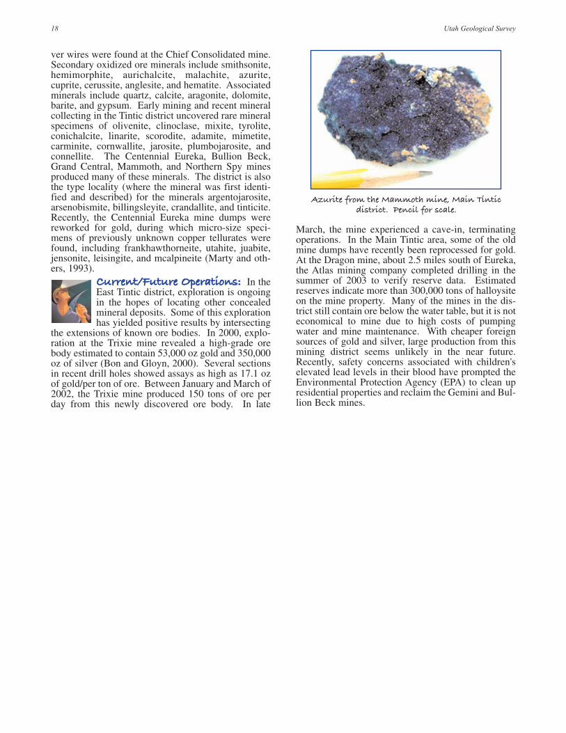
Azurite from the Mammoth mine, Main Tinticdistrict. Pencil for scale.

19Selected Mining Districts of Utah
BBaacckkggrroouunndd:: The Mountain Lake mining districtencompasses an area from Warm Springs (north endof Salt Lake City) to the head of Utah Lake in UtahCounty. Soldiers stationed at Fort Douglas in SaltLake City formally created the district in 1868. Manyof these soldiers already had mining experience fromColorado, Nevada, and California. In 1870, the dis-trict was divided into several separate districts includ-ing Big Cottonwood, Little Cottonwood, and Ameri-can Fork. The location, access, production, history,and current status for each of these districts are dis-cussed separately. The geology and mineralogy of thethree districts are similar and discussed below.
GGeeoollooggyy:: From the Precambri-an (900 million years ago) toMississippian (325 million years
ago), marine sedimentary rocks (sandstone, lime-stone, and shale) were deposited on a shallow shelfalong the eastern edge of a large ocean. In the MiddleJurassic to Tertiary (170 to 40 million years ago),these rocks were folded and faulted during the Sevierorogeny. Approximately 40 to 25 million years ago,magma bodies intruded these fractured marine rocks
forming the quartz monzonite of the Little Cotton-wood stock and granodiorite of the Clayton Peak andAlta stocks. Three types of ore bodies were formed byhydrothermal (hot) fluids from these intrusive rocks:(1) replacement of carbonate rock (limestone), (2)metallic fissure veins, and (3) skarn deposits.Replacement deposits are the most common type ofdeposit and exist throughout the Mountain Lake dis-trict. Limestone rock layers of Middle Cambrian toMississippian (515 to 325 million years old), particu-larly the Maxfield Limestone, Gardison Limestone,Deseret Limestone, and Fitchville Formation, seem tohave been the most favorable for ore deposition(James, 1979). In some replacement deposits, such asthose in the Emma mine, renewed faulting has cutsome of the ore bodies and displaced parts as much asseveral hundred feet. Fissure deposits occur in quartzveins within the Tintic Quartzite and generally persistmany hundreds of feet, notably at the Howell mine(James, 1979). Skarn deposits are generally small andtend to be the most common near the contact of thestocks with carbonate rocks. At the Big Cottonwoodmine, the skarn deposits are located at the contact of
MMoouunnttaaiinn LLaakkee MMiinniinngg DDiissttrriicctt((BBiigg CCoottttoonnwwoooodd,, LLiittttllee CCoottttoonnwwoooodd,, && AAmmeerriiccaann FFoorrkk))
Ore bin at the Cardiff mine, Mill D South Fork, Big Cottonwood district.

20 Utah Geological Survey
the carbonate rocks (Gardison, Deseret, and HumbugFormations) with the Alta and Clayton Peak stocks(James, 1979). All of these ore bodies are found eitheradjacent to the intrusives, within the intrusives, oralong and at the intersection of faults.
MMiinneerraallooggyy:: The major ore bodiesin the Big Cottonwood, Little Cotton-wood, and American Fork districts arevein and replacement deposits contain-
ing variable amounts of lead, zinc, manganese, silver,and copper with associated gold. Some deposits con-tain tungsten- and molybdenite-bearing minerals. Theprimary ore-bearing minerals include galena, sphal-erite, argentite, tetrahedrite, bismuthinite, enargite,molybdenite, scheelite, bornite, pyrite, and gold. Sec-ondary ore minerals include smithsonite, cerussite,malachite, azurite, aurichalcite, wulfenite, pyromor-phite, hemimorphite, plumbojarosite, pyrolusite, andstolzite. Wulfenite and hemimorphite occur as smallwell-developed crystals in the oxidized ores of theMichigan-Utah, Alta Consolidated, and Flagstaffmines (Wilson, 1995). Associated minerals found inthe districts are calcite, rhodochrosite, quartz, mag-netite, epidote, barite, siderite, beaverite, gypsum, andludwigite. Ludwigite, a relatively rare iron borate, is
abundant at the Big Cottonwood mine along withmagnetite, bornite, chalcopyrite, malachite, and otherassociated minerals (Wilson, 1995). Tungstenite (75percent tungsten and 25 percent sulfur) was firstfound and identified from the Emma mine (Calkinsand Butler, 1943). Tungstenite is a rare mineral foundwith pyrite, galena, sphalerite, tetrahedrite, andquartz.
Hemimorphite from the Wasatch mine,Big Cottonwood district.

21Selected Mining Districts of Utah
LLooccaattiioonn:: TheBig Cottonwooddistrict is approx-imately 18 miles
southeast of downtown SaltLake City on both sides ofBig Cottonwood Canyon.Main access to the district isup Big Cottonwood Canyonon State Highway 190.
PPrroodduuccttiioonn::It is impossibleto give accuratemetal produc-tion data for the
Big Cottonwood district,because ores from the dis-trict have been minedthrough tunnels on bothsides of the ridge betweenBig Cottonwood and LittleCottonwood Canyons. Also,historical records havegrouped the Little Cotton-wood and Big Cottonwood districts’ production val-ues together. From 1867 to 1976, the two districtsproduced approximately 30,600 ounces of gold, 17.5million ounces of silver, 18.1 million pounds of cop-per, 252 million pounds of lead, and 4.7 millionpounds of zinc (James, 1979). Of the two districts,Big Cottonwood has produced approximately 60 per-cent of the total combined metal production.
HHiissttoorryy:: In 1870, the Big Cottonwooddrainage basin was designated as the BigCottonwood mining district, separatefrom the Little Cottonwood district to the
south. The Reed and Benson mine, located in Mill DSouth (Cardiff) Fork, was one of the major producersduring the early years of the district. The mine waslocated on high, sheer vertical limestone cliffs where
BBiigg CCoottttoonnwwoooodd MMiinniinngg DDiissttrriicctt
km210
mi10
Prince ofWales mine
Big Cottonwoodmine
Wasatchdraintunnel
Carbonatemine
Wasatchmine
Reed andBenson
mine
Cardiffmine
Maxfieldmine
TarBabymine
Howellmine
Newmantunnel(Blind
Miner'smine)
190
MountRaymond10,241 ft.
GobblersKnob
10,246 ft.
SilverFork
Brighton
Solitude
StormMountain9,524 ft.
Broads ForkTwin Peaks
Dromedary Peak11,107 ft.
LakeLillian
LakeBlanche
LakeFlorence
ToSaltLakeCity
MountWolverine10,795 ft.
LakeMary
LakeMartha
LakeCatherine
Twin LakesReservoir
Alta
AlbionBasin
FlagstaffMountain10,530 ft.
SuperiorPeak
11,050 ft.
Kessler Peak10,403 ft.
ClaytonPeak
10,721 ft.
Mineral
Fork
Fork
Fork
Mill B
South
Broads
Mill B
Norh
Fork
Mill AGulch
But
ler
Fork
Mill
D
For
k
Mill
DSo
uth
For
k
Reed
an
d B
enso
n R
idg
eD
aysF
ork
B IG
COTTONWOOD CANYON
LittleCottonwood
Canyo
n
N
SUMMIT CO.
SALT LAKE CO.
ToParkCity
GuardsmansPass
11,328 ft.
11,330 ft.
Explanation
Approximateboundary ofdistrict
Shaft
Adit
WASATCH CO.
Newman tunnel (Blind Miner’s mine), Big Cottonwood district.

22 Utah Geological Survey
miners had to be roped in to make a trail. A tramway1582 feet long was constructed to transport the orefrom the mine tunnel to the wagon road below (James,1979). By 1872, over 650 claims were staked in thedistrict. The early boom period lasted between 1871and 1885, as production increased in rich oxidized andenriched ore. Major producers during this period in-cluded the Cardiff, Carbonate, Howell, Prince ofWales, Big Cottonwood, Tar Baby, and Maxfieldmines, in addition to the Reed and Benson mine. By1885, the shallow, rich ore bodies had been exhausted,and many of the miners had moved on to other boomareas. The start of the twentieth century brought arenewed interest in many of the mines due to risingsilver prices and new mining/processing technology.Larger mining companies were organized to developthe deep prospects of the region. The largest ore bodyof the district was discovered in 1914 at the Cardiffmine. The ore body was 10 feet thick and continuedhorizontally for more than 300 feet. By the late1920s, metal prices had dropped and only a few of themines remained in op-eration.
In 1929, J.L. (Roy) Newman was almost com-pletely blinded by a blast from a mining accidentwhile working one of his mines. Known ever since asthe “Blind Miner,” he continued to work his mine, theNewman tunnel, for 45 years, driving over 1500 feetof straight tunnel (James, 1979). Roy managed thistask by using a tiny area of sight remaining in the cor-ner of his left eye to sight down the tunnel with alighted lamp and a rock pick (Newman, undated).
In the early 1940s, mining production was brieflyheightened by high metal demands of World War II.During the summer of 1955, the Wasatch Drain Tun-nel was constructed on the other side of the ridge inLittle Cottonwood Canyon to drain water and remove
ore from the Cardiff mine. The tunnel was used until1967. Between 1955 and 1967, approximately 23,000tons of ore were removed from the Cardiff mine thatcontained over 230 ounces of gold, 344,000 ounces ofsilver, 850,000 pounds of copper, 6 million pounds oflead, and 5.7 million pounds of zinc (James, 1979).
CCuurrrreenntt//FFuuttuurree OOppeerraattiioonnss:: Thedistrict is currently inactive and likely toremain so. Metal prices (gold, silver, andlead) have been too low to warrant furthermineral exploration. Minable ore in
known deposits was exhausted by the mid-1960s andother discoveries were small and uneconomic.
The “Blind Miner,” Roy Newman. Photo courtesyof the Utah State Historical Society.

23Selected Mining Districts of Utah
LLooccaattiioonn:: TheLittle Cottonwooddistrict is locatednear the headwaters
of Little Cottonwood Creek,approximately 27 miles south-east of downtown Salt LakeCity. The only access to thedistrict is up Little CottonwoodCanyon on State Highway 210.Travel approximately 8 milesup the canyon to the town ofAlta, which is the center pointfor the district.
PPrroodduuccttiioonn::It is impossibleto give accuratemetal produc-tion data for the
Little Cottonwood district,because ores from the districthave been mined through tun-nels on both sides of the ridgebetween Little Cottonwoodand Big Cottonwood Canyons(James, 1979). Also, historicalrecords have grouped the LittleCottonwood and Big Cotton-wood districts’ production values together. From1867 to 1976, the two districts produced approximate-ly 30,600 ounces of gold, 17.5 million ounces of sil-ver, 18.1 million pounds of copper, 252 million
pounds of lead, and 4.7 million pounds of zinc (James,1979). Of the two districts, the Little Cottonwood dis-trict produced approximately 40 percent of the totalcombined metal production.
LLiittttllee CCoottttoonnwwoooodd MMiinniinngg DDiissttrriicctt
South Hecla mine, Little Cottonwood district circa early 1900s.Photo courtesy of the Utah State Historical Society.
SNOWBIRDSki Resort
Brighton
Alta Michigan-Utahmine
Emmamine
SouthHeclamine
ColumbusRexalltunnel
Flagstaffmine
Sellsmine
AltaConsolidated
mine
Emilymine
Albionmine
Wasatchdraintunnel
Twin LakesReservoir
MountWolverine10,795 ft.
FlagstaffMtn.
10,530 ft.
MountBaldy
11,068 ft.
Li t t leCottonwood
Canyon
Broads ForkTwin Peaks
DromedaryPeak
11,107 ft.
Deaf Smith Canyon
LowerBells Canyon
Reservoir
210
210209ToSandy City
ToSalt Lake City
Bells Canyon NAmerican Fork
Twin Peaks
AlbionBasin
SecretLake
WhitePineLake
Red PineLake
UpperRed Pine
Lake
SuperiorPeak
11,050 ft.
SALT LAKE CO.
UTAH CO.
White
PineF
ork
Maybird
Gulch
Hog
umF
ork
Coalpit
Gulch
11,328 ft.11,330 ft.
11,489 ft.11,433 ft.
km210
mi10
Explanation
Approximateboundary ofdistrict
Shaft
Adit

24 Utah Geological Survey
HHiissttoorryy:: In 1865, the first miningclaims were filed north of today’s townof Alta by Silas Brain. Most of theclaims were long and narrow: 100 feet
wide and 2000 to 3000 feet long. In 1868, J.B. Wood-man and Robert Chusholm discovered silver mineral-ization and created the Emma mine. Productionbegan in 1870, and in the early mining stages the orewas incredibly rich, assaying 100 to 216 ounces of sil-ver per ton (Calkins and Butler, 1943). Much of theore was so rich that it could be shipped to New Yorkvia railroad and then by ship to Liverpool, England tobe processed for a profit. J.E. Lyon, T.W. Park, andH.H. Baxter bought shares of the Emma mine in 1871for $375,000. Probably realizing the ore body wasabout to be played out, production was dramaticallyincreased to trick potential buyers. The sensationalprofits obtained from the increase in productionenabled the promoters to sell the mine in 1872 to aBritish company for a million English pounds. Afterthe sale, the ore body was discovered to suddenly endagainst a post-mineral fault. This created an interna-tional incident, because of the participation by theAmerican foreign minister to London, RobertSchenck (one of T.W. Park’s company board of direc-tors). Extensive court proceedings and a U.S. Con-gressional investigation by the U.S. House of Repre-
sentatives Committee on Foreign Affairs brought outmany of the details, but failed to establish the extentof Schenck’s role. Schenck later resigned his post asthe American foreign minister to London and returnedto the United States. The Emma mine continued toproduce low-grade ore until 1879. For the next 30years, the mine remained idle and the lower workingsfilled with water. The continuation of the ore body onthe other side of the fault was not located until 1916by Joseph J. Beeson, a geologist from Stanford Uni-versity and the University of Utah. Shortly after thediscovery, the Emma mine was dewatered and in 1917the first new shipment of ore left the mine. The minecontinued to operate until 1919.
Other mines that produced ore in the early historyof the district include the Flagstaff, Albion, and Emily.Of these, the Flagstaff mine was the most productive,yielding approximately 100,000 tons of high-gradesilver ore from 1869 to 1880 (Butler and others,1920). Between 1901 and 1940, the largest producersof the district were the Michigan-Utah, South Hecla,Emma, Columbus-Rexall, and Sells (Calkins and But-ler, 1943).
CCuurrrreenntt//FFuuttuurree OOppeerraattiioonnss:: Allmining in the district has been suspendeddue to low metal prices, high cost of min-ing, or depletion of mineable ore bodies.

LLooccaattiioonn:: The American Forkdistrict is located near the head-waters of American Fork Creek,approximately 20 miles north-east of Lehi, Utah County.
PPrroodduuccttiioonn:: From 1870 to1976, the American Fork dis-trict produced approximately2.45 million pounds of copper,
36.4 million pounds of lead, 5.54 millionpounds of zinc, 45,000 ounces of gold, and2.39 million ounces of silver (Perry andMc-Carthy, 1977).
HHiissttoorryy:: In 1869, ore wasfound at a locality referred toas Miller Hill in AmericanFork Canyon. The district was
officially organized in 1870. Little workwas done on the located prospects until theautumn of 1870 when a large ore body wasdiscovered at the Miller mine. This orebody was mined until 1876. Average as-says of ore were 40 to 54 percent lead, 30to 47 ounces of silver per ton, and $2 to $10in gold per ton (Calkins and Butler, 1943).Other properties that produced ore prior to1880 include the Dutchman, Pittsburg, Sil-ver Bell, Yankee, and Whirlwind mines.The district was active until 1963; majorperiods of production occurred during1870-80, 1905-09, 1917-18, 1923-29,1931-41, and 1946-49 (Perry and Mc-Carthy, 1977). Major mines that producedore during these periods include the Miller,Pacific, Pittsburg, Dutchman, Whirlwind,and Yankee.
CCuurrrreenntt//FFuuttuurree OOppeerraattiioonnss:: All of the mines are currently inactive. In 2000, Unico, Inc. re-opened the Silver Bell mine and began restoring the underground workings. In 2003, exploration workcontinued on the property. Safety concerns prompted the cleanup of the Pacific mine tailings by theU.S. Forest Service in the spring of 2003.
25Selected Mining Districts of Utah
AAmmeerriiccaann FFoorrkk MMiinniinngg DDiissttrriicctt
Pacific mine, American Fork district circa 1916. Photo courtesy of Melvin Anderson.
UTA
H C
O.
WA
SATCH
CO
.
SALT L
AKE CO.
UTAH CO.
Wide Hollow
km210
mi10
Pittsburgmine
Dutchmanmine
Yankeemine
Pacific mine
Whirlwindmine
Miller mine
SilverBellmine
Timpanogos CaveNational Monument
92
N
ForestLake
SilverLake
AMERICAN
FO
RK
CA
NY
ON
Major
EvansG
ulch
Mary
Ellen
Gulch
L O N E P E A K
W I L D E R N E S S
A R E A
MineralBasin
PittsburgLake
Miller Hill10,264 ft.
AmericanForkTwinPeaks
WhiteBaldy
11,321 ft.
ToAmericanFork
ToAspen Grove
Box Elder Peak11,101 ft.
11,489 ft.11,433 ft.
Silver Lake Flat Reservoir
FS 085
AlpineScenic
Highway
Tibble ForkReservoir
Explanation
Approximateboundary ofdistrict
Shaft
Adit

26 Utah Geological Survey
LLooccaattiioonn:: The ParkCity mining district isnear Park City in south-western Summit and
northwestern Wasatch Counties.The mines are south of Park City.
PPrroodduuccttiioonn:: From1875 to 1982, the ParkCity mines produced16.7 million tons of
ore recovering 1.45 million ouncesof gold, 253 million ounces of sil-ver, 2.7 billion pounds of lead, 1.5billion pounds of zinc, and 129million pounds of copper (John, inpreparation). With these totals, thePark City mining district is thethird-leading non-ferrous metalproducer in the state (John, in pre-paration).
HHiissttoorryy:: The ParkCity district compris-es three former dis-tricts (Uinta, Snake
Creek, and Blue Ledge), and whomade the first mineral discovery inthe district is unknown. The firstclaims recorded were the YoungAmerica in 1868 and the GreenMonster in 1869 (Boutwell, 1912).A short time later Rufus Walkerlocated the Walker and Webster
PPaarrkk CCiittyy MMiinniinngg DDiissttrriicctt
The Ontario mine, Park City mining district circa 1885.Photo courtesy of the Utah State Historical Society.
JordanelleReservoir
Ontariomine
Daly-Judgemine
Daly Westmine
Silver King mine
Park CityConsolidated
mine
Silver KingCoalition mine
Mayflowermine
Walker andWebster
mine
Flagstaffmine
Green Monster mine
Park-Utahmine
Explanation
Approximateboundary ofdistrict
Shaft
Adit
ParkCity
BaldMountain9,346 ft.
Bald EagleMountain
Th
ayn
es C
an
yon
KeetleyJunction
To Silver Junction
248
224
N
Dee
r V
al l
ey
SUMMITCO.
WASATCHCO.
SALTLAKE
CO.
JupiterHill
9,998 ft.
GuardsmanPass
To Kimball Junction
ToHeberCity
ToSalt Lake City
40
189
248
Clayton Peak10,721 ft.
The CanyonsSki Resort
Brighton
To Midway
SilverLake
BloodsLake
LakeBrimhall
SilverLakeIslet
MidwayReservoir
EmpireCanyon
Park CityMountainSki Resort
DeerValley
SkiResort
Silver Creek
Ont
ario
Cyn
.
km210
mi10

claim and exploration began in earnest. With anincreasing number of discoveries, the Uinta districtwas organized in 1869. The Snake Creek and BlueLedge districts were established in the spring of 1870.The first recorded production of lead-silver ore in thePark City district was from the Flagstaff mine in 1871.The discovery of the Ontario vein in 1872 by RectorSteen, John Kain, and Gus McDowell catapulted thedistrict into prominence (John, in preparation). Thevein was exposed on the surface as a knob, protrudingtwo inches out of the ground. The first ore mined fromthis property averaged $200 dollars of silver per ton.These prospectors subsequently sold the mineralrights to George Hearst and partners in 1872 for theamount of $27,000 (Hampshire and other, 1998).
In 1881, a Cornish pump was installed in theOntario mine to pump out ground water (John, inpreparation). The pump had a wheel that was 30 feetin diameter, weighed 70 tons, and pumped 2560 gal-lons of water per minute. As the mine became deep-er, the Cornish pump became inefficient at handlingthe excessive amount of water.
In 1888, excavation work began on the 3-mile-long Ontario drain tunnel to eliminate water from thelower workings of the mine. The tunnel took six yearsto complete at a cost of $400,000. The tunnel linkedup with the 1500-foot level of the mine and was capa-ble of draining up to 13,000 gallons of water perminute (John, in preparation). In its lifetime, theOntario produced ore worth over $50 million, makingthis property one of the best land purchases of alltime. The Ontario was mined from the surface to adepth of 2000 feet, and was highly productive in theupper 1500 feet. The ore averaged 21 ounces of silverper ton and approximately 3 percent lead (Garmoeand Erickson, 1968). Other major mines in the districtinclude the Daly West, Daly-Judge, Park-Utah,Mayflower, Park City Consolidated, and Silver King.
During World War II, metal production from themines decreased dramatically. Many of the skilled
workers were sent to the war and government restric-tions prevented the search for new mineral deposits.
In 1958, the United Park City Mines, the last sur-viving mining company in Park City, looked closely attheir property for other ways to generate money.Because the silver market was on the downside, thecompany turned to skiing with assistance from thefederal government. With a federal loan of $1.2 mil-lion and land ownership of the surface rights toapproximately 10,000 acres of mountainside, the min-ing company created Park City’s first ski resort. In1963, Treasure Mountain, now known as the ParkCity Mountain Resort, opened to the public.
Mining continued at the Mayflower mine, wherethe ore contained higher gold and copper values perton than any of the other mines in the district. In1966, the Mayflower mine ranked sixth in gold pro-duction in the United States, and in 1967 the mineproduced 72,000 ounces of gold (Quinlan and Simos,1968). The Mayflower mine closed in 1972.
After a period of inactivity, mining resumed at theOntario mine in the spring of 1975. For three years,the Ontario mine produced ore until its closure in1978 (John, in preparation). The Noranda MiningCompany leased the mine from 1979 to 1982. In1995, the Ontario mine was opened for the first timeto tourists. Called the Park City Mine Adventure,tourists could descend 1500 feet underground to viewthe Cornish pump, minerals, and old mine workings.Unfortunately, this latest venture lasted only severalyears.
GGeeoollooggyy:: Sedimentary rocksin the Park City district range inage from Precambrian (1400
million years old) to Jurassic (160 million years old).During the Middle Jurassic to Tertiary (170 to 40 mil-lion years ago), these rocks were folded and faultedduring the Sevier orogeny. During the Tertiary (35 to34 million years ago), six magma bodies intruded theoverlying sedimentary rocks. Hydrothermal (hot) flu-ids associated with the cooling magma migratedupward through pre-existing faults and fractures cre-ating the important ore deposits of the Park City min-ing district. Limestone rock layers of Pennsylvanianto Late Permian (300 to 240 million years old) age,particularly the Humbug and Park City Formationsand the Weber Quartzite, seem to have been the mostfavorable for ore deposition (John, 1997). The ParkCity mining district contains two major types of oredeposits: (1) fissure or lodes that contain the highest-grade silver mineralization, and (2) limestone replace-ments that contain less silver, but higher grades oflead and zinc. The vein or lode deposits were the firstdiscovered, contained the richest ore, and were theeasiest to mine due to their close proximity to the sur-face. The best examples of these ore deposits can befound at the Mayflower and Park-Utah mines. ThePennsylvanian Weber Quartzite is the main host rockfor fissure deposits (John, 1997). After exhaustion ofthe rich lode ores, replacement deposits became themajor source of production. About 75 percent of theore recovered in the district was from replacement
27Selected Mining Districts of Utah
Cornish pump at the Ontario mine. Photo courtesy ofthe Utah State Historical Society.

28 Utah Geological Survey
deposits in Park City Formation (Garmoe and Erick-son, 1968). Major replacement bodies in the districtinclude those exposed in the Silver King, Ontario, andthe Daly West mines (John, 1997).
MMiinneerraallooggyy:: The primary ore-bear-ing minerals in the district are galena,pyrite, sphalerite, gold, stibnite, tetra-hedrite, jamesonite, and boulangerite.Secondary ore minerals include cerus-
site, anglesite, bindhamite, chlorargyrite, argentite,malachite, and azurite. Associated minerals are cal-cite, siderite, quartz, fluorite, barite, and gypsum. Themining district is well known for its fantastic pyritecrystals. Pyrite cubes up to 1 inch were found in someof the mines of the district. One specimen in the UtahMuseum of Natural History mineral collection is a
large cluster of crystals, the largest crystal measuringover 3 inches across.
CCuurrrreenntt//FFuuttuurree OOppeerraattiioonnss:: Thelast ore was produced from the district in1978 from the Ontario mine. All of themines are presently closed or inactive dueto low silver prices and the high cost of
rehabilitation and mining. To generate revenue, sev-eral of the mines sold the water leaking into the minesto ski resorts for their snowmaking machines. Somemines were maintained, such as the Ontario, but inJuly 2003 the United Park City Mining Company soldall interests to Capital Partners LLC. Capital PartnersLLC is a development corporation and is unlikely touse the property for mining. Real estate and skiing arenow the main revenue sources for the area.
Pyrite from the Silver King Coalition mine. Stibnite from the Silver King Coalition mine.U.S. quarter for scale.

29Selected Mining Districts of Utah
LLooccaattiioonn:: The San Franciscomining district is in the southernone-third of the San Franciscomountain range approximately
15 miles west of the town of Milford inBeaver County. The district can be reachedby traveling west from Milford on StateHighway 21 to the ghost town of Frisco.
PPrroodduuccttiioonn:: From 1870 to1976, the San Francisco districtproduced 2.36 million tons ofore that yielded 44,900 ounces
of gold, 19.6 million ounces of silver, 44.1million pounds of copper, 405 millionpounds of lead, 46.8 million pounds of zinc,and 892 pounds of tungsten (Wray, in prepa-ration).
HHiissttoorryy:: In 1870, the Cactusore body was the first metallicmineral deposit discoveredhere, and the district was for-
mally organized in 1871. Four years later,the Horn Silver ore body (the largest lead-silver orebody ever found in Utah) was discovered by JamesRyan and Samuel Hawkes (Butler, 1913). These twoprospectors sunk a shaft 30 feet and encountered chlo-rargyrite or horn silver (a rich silver ore), hence thename, Horn Silver mine. Fearing that the ore depositwould be small, they decided to sell the claim fivemonths later, in 1876, to A.G. Campbell, MatthewCullen, Dennis Ryan, and A. Byram for $25,000.These new owners proceeded to develop the ore body,erect a smelter, and process and sell the ore. Duringthe three-year period from 1876 to 1879, the totalvalue of mine production was $2.54 million, which
included almost 50 percent paid out as dividends. In1879, they sold the greater part of their interest to thenewly incorporated company, Horn Silver Mining, for$5 million. The town of Frisco was established and by1880 had about 800 inhabitants. Drinking water wasbrought to the town via the railroad from Black Rock,Utah about 30 miles to the east, or hauled by wagonfor 10 miles from springs in the Wah Wah Mountainsto the west.
From 1880 to February 12, 1885, the mine was aconstant producer until the upper 800 feet of the orig-inal shaft caved in. The desire for high productionpossibly caused disregard for good mining practice;
SSaann FFrraanncciissccoo MMiinniinngg DDiissttrriicctt
The King David mine, southwest of the former town site of Frisco, San Francisco mining district.
King Davidmine
FriscoContact
mine
Horn Silvermine
BeaverCarbonate
group
Cupricmine
Cactusmine
SquawG
ulch
Carbonate
Gulch
Sa
n
Fr
an
ci
st
o
Mt
ns
.
km210
mi10
ToMilford
ToGarrison,Nevada
Newhouse
SquawPeak
7,212 ft.
N
Frisco
SquawSpring
GrampianHill
21
ExplanationApproximateboundary of districtShaftOpen pitAditAbandoned/formertown site
Wa
h W
ah
Mtn
s.

30 Utah Geological Survey
miners reported the mine creaking and shifting priorto the cave-in. Luckily, the mine collapsed during ashift change and no one was hurt. The cave-in was soviolent that windows shattered 15 miles away in thetown of Milford. This was the beginning of the endfor the Horn Silver mine, town, and district. Miningceased while the underground workings wereimproved and a new 1600-foot-deep shaft (Horn No.1) was constructed east of the old shaft. Mining re-sumed in 1886 and continued until 1952 with a briefperiod of inactivity from 1932 to 1937. From 1875 to1952, the Horn Silver mine produced 834,000 tons ofore yielding 196,000 tons of lead, 17.9 million ouncesof silver, 25,700 ounces of gold, 9,650 pounds of cop-per, and 23,300 pounds of zinc (Wray, in preparation).
Other mines that produced ore in the districtinclude the Beaver Carbonate group, Cactus, KingDavid, Cupric, and the Frisco Contact. Of these, theBeaver Carbonate group (including the Carbonate,Rattler, and Quadmetals mines) was the largest silverproducer. From 1879 to 1942, this group produced anestimated 92,900 tons of ore generating 12 millionpounds of lead and 1.18 million ounces of silver(Wray, in preparation). The Cactus mine was the mostproductive for gold and copper. From 1870 to 1957,the Cactus mine produced 1.40 million tons of oreyielding 13,500 ounces of gold, 34.5 million poundsof copper, and 301,000 ounces of silver (Wray, inpreparation).
GGeeoollooggyy:: Sedimentary rocksin the district consist of lime-stone, dolomite, and shale rang-
ing in age from Late Cambrian (515 million years old)to Late Ordovician (458 million years old). Theserocks formed from sediments that were deposited on awide, shallow shelf along the eastern edge of a largeocean. From the Middle Jurassic to early Tertiary(170 to 40 million years ago), these rocks were uplift-ed, folded, and faulted during the Sevier orogeny.Approximately 35 million years ago, volcanic lavaflows covered the immediate area followed by magmaintrusions 31 to 28 million years ago (Best and others,1989). Hydrothermal (hot) fluids from the coolingmagma bodies migrated upward through pre-existingfaults and fractures creating the ore deposits of thedistrict: (1) replacement deposits, (2) skarns, and (3)breccia pipes. Replacement deposits are the mostimportant type of ore body found in the district. TheHorn Silver ore body is an example of a replacementdeposit that formed along the Horn Silver fault. Themaximum dimensions of the ore body were approxi-mately 700 feet along strike, 100 feet in width, and1000 feet in length (Whelan, 1973). The ore host rockconsists of Cambrian limestone and shale of the OrrFormation (approximately 515 million years old).
Skarns are small deposits found along the contact ofthe intruded rock (quartz monzonite) with carbonaterocks in the district. At the Cupric mine, copper orewas mined from a skarn deposit. Mineral depositswithin the granodiorite in the district are referred to asbreccia pipes or breccia zones. A breccia pipe is apipe-like body composed of angular or rounded rockfragments of the country rock held together by naturalmineral cement. At the Cactus mine, breccia pipesmay have formed from faulting or hydrothermal alter-ation (where soluble material has been partly or com-pletely removed by a hot water solution causing theoverlying rock to collapse).
MMiinneerraallooggyy:: The ore bodies at theSan Francisco district contain gold, lead,silver, zinc, and copper. Primary ore-bearing minerals include chlorargyrite,
galena, sphalerite, wurtzite, chalcopyrite, stibnite,argentite, bornite, pyrite, and hematite. The zinc sul-fides of sphalerite and wurtzite are common in theores of the Horn Silver mine. These zinc minerals willluminate a yellow color when exposed to ultravioletlight (called fluorescence). These minerals will alsospark when scratched with a metallic object. This rareand unusual property is known as triboluminescence.Secondary oxidized ore minerals are cuprite, azurite,malachite, cerussite, smithsonite, scorodite, andwulfenite. Associated minerals include barite, gyp-sum, chalcanthite, beaverite, jarosite, wollastonite,and calcite. Chalcanthite and gypsum coat the wallsof the King David mine. Beaverite, a hydrous sulfateof copper, lead, and iron, was first found and identi-fied from the Horn Silver mine (Butler and Schaller,1911).
CCuurrrreenntt//FFuuttuurree OOppeerraattiioonnss:: Ex-ploration work is presently being conduct-ed by Franconia Minerals Corporation onthe Horn Silver/King David mine proper-ties. All other mines are currently inactive.
Chalcanthite from the King David mine.

31Selected Mining Districts of Utah
LLooccaattiioonn:: The Iron Springsmining district is about 20 mileswest of Cedar City, along StateHighway 56 in Iron County.
The district comprises three areas: TheThree Peaks, Granite Mountain, and IronMountain.
PPrroodduuccttiioonn:: From 1923 to1968, the district produced anestimated 87 million tons ofiron ore (Bullock, 1970). Most
of this production was achieved throughopen-pit mining methods using steamshovels and diesel-powered equipment. Aresource of as much as 500 million tons ofore is proven to still be available, most of itin the Iron Mountain area (Bullock, 1970).
HHiissttoorryy:: Parley P. Prattdiscovered the iron depositsin 1849, while exploringsouthern Utah for the L.D.S.
Church. His discovery led the L.D.S. Church to callfor 120 men, 30 women, and 18 children to volunteertheir services to produce iron from the ore (Larson,1963). In 1852, this area became the first site west ofthe Mississippi River where iron was produced fromnative ores (Larson, 1963). After thousands of workhours, only 25 tons of iron were produced. After thisventure ended in failure, several other unsuccessful
attempts were made to process the iron ore. Duringthe 1920s, new advancements in mining technologyand iron production resulted in profitable miningoperations. From 1923 to 1965, 72.1 million tons ofore were mined (Mackin, 1968). In 1981, miningoperations at the Comstock and Mountain Lion prop-erties were suspended due to increased operating costsand foreign competition. A resurgence in the steel
IIrroonn SSpprriinnggss MMiinniinngg DDiissttrriicctt
The Desert Mound pit, Iron Springs mining district.
The Three Peaks
Neck of the
Desert
AN
TE
LO
PE
RA
NG
E
Stoddard Mtn.
LindsayHill
mine
Excelsiorpit
Blowoutpit
Iron M
ountain
Comstockpit
Mt. Lionpit
Smith mine
Great Westernmine
Grani
teM
ount
ain
S we t t H
i l l s
E i g h t mi l e H
i l l s
DesertMound
pit
N
ToNewcastle
ToNewcastle
IronSprings
56
ToCedar
City
Mt. Claron6,296 ft.
km420
mi20
ExplanationApproximateboundary of districtOpen pitAbandoned/formertown site
Comsto
ck R
d.
Iron Springs Rd.
To Lund
Desert Mound Rd.

32 Utah Geological Survey
industry occurred in 1989 with the reopening of theComstock mine. Mining was suspended in 1995 dueto cheaper foreign sources of iron.
GGeeoollooggyy:: Approximately 170million years ago (Middle Juras-sic), a long, narrow, shallow sea
originating from the north covered the region, intowhich a sequence of marine limestone was deposited.By the Late Jurassic (150 million years ago), the seahad receded. From the Late Jurassic to late Tertiary(150 to 40 million years ago), sandstone, conglomer-ate, shale, and limestone were deposited. Mineraliza-tion began about 20 million years ago with the intru-sion of several magma bodies into the overlying sedi-mentary rock (Hintze, 1988). As the magma cooled,it formed quartz monzonite. Hot fluids released fromthe cooling quartz monzonite migrated upwardthrough fractures in the quartz monzonite and overly-ing sedimentary rock. When these fluids cooled, theimportant iron ore deposits of the district wereformed. Three different types of ore deposits werecreated: massive replacement deposits, breccia fill-ings, and fissure veins. The replacement deposits con-tain most of the iron ore found in the district. Massivereplacement iron ore bodies are found in the MiddleJurassic (approximately 170 million years old) Home-stake Limestone Member of the Carmel Formation(Stokes, 1986). The Lindsay Hill mine is a goodexample of a massive replacement deposit. Brecciafillings are composed of angular broken-up rock frag-ments held together by natural mineral cement. In theIron Springs district, breccias are formed by faultingand later replaced by iron ore, such as at the Blowoutmine. Common in the quartz monzonite, fissure veindeposits were probably some of the first iron oredeposits located in the district. Many of these de-posits were too thin to be mined economically, and
only a small proportion were mined, such as theExcelsior and Great Western fissures where the veinswere quite thick (approximately 12 feet).
MMiinneerraallooggyy:: Magnetite and hem-atite are the primary ore-bearing miner-als. Massive magnetite can be found inall of the mines of the district. Magnetite
crystals or crystal aggregates can be found in fissureveins in some of the mines. Crystals can reach 2 to 3inches across. In some mines, such as the Blowoutand Excelsior, magnetite occurs in a fibrous form.Other minerals that can occur with the magnetiteinclude calcite, fluorapatite, quartz (variety amethystor crystal), chalcedony, pyrite, marcasite, siderite,barite, and epidote. These associated minerals gener-ally occur in open spaces within a vein and usuallyform good crystals.
CCuurrrreenntt//FFuuttuurree OOppeerraattiioonnss:: Al-though large reserves (approximately 500million tons of ore) still exist at the IronMountain mine (Bullock, 1970), the dis-trict is currently inactive. Geneva Steel (in
Utah County) was the main purchaser of ore from thedistrict. Early in 2003, Geneva Steel declared bank-ruptcy and their assets sold to the highest bidder. InFebruary 2004, Geneva Steel sold its equipment toQingdao Iron & Steel, a Chinese company that plansto dismantle, ship, and install the equipment in theChinese province of Shandong (Anderson, 2004). InFebruary 2005, Palladon Ventures Ltd. secured a con-tract to buy an idle iron mine near Cedar City fromGeneva Steel for $10 million (Oberbeck, 2005). Pal-ladon Ventures Ltd. also plans to build a steel milladjacent to the mine that could cost as much as $1 bil-lion. Currently (2005), the Lindsay Hill mine is usedas a landfill for Cedar City.
Fluorapatite on weathered magnetite from the IronMountain area.
Magnetite from The Three Peaks area.

33Selected Mining Districts of Utah
LLooccaattiioonn:: The Silver Reef mining dis-trict is in southwestern Utah, just north ofthe town of Leeds in Washington County.Principal access is approximately 15 miles
north of St. George from the Leeds exit (#23) of Inter-state 15. A museum containing a treasure trove of his-torical information on Silver Reef is located in the oldWells Fargo Bank building in Leeds at the Silver Reeftown site.
PPrroodduuccttiioonn:: The mining district isunique; it is the only major mining dis-trict in the United States that producedsilver ore from sandstone. From 1875 to
1972, the Silver Reef district produced 7.52 millionounces of silver, 665 ounces of gold, and 10.7 millionpounds of copper (Stowe, 1975). The 665 ounces ofgold reported by Stowe is likely in error because dis-trict boundaries were not specific and gold productionfrom other districts was added to the total. The districtalso produced 8400 pounds of uranium oxide from1950 to 1957 (Dasch, 1967). Average grade of the sil-ver ore hoisted was 20 to 50 ounces per ton (Proctorand Brimhall, 1986).
HHiissttoorryy:: John Kemple is credited forthe discovery of silver ore at Silver Reefin 1866. His assayed ore samples werefound to be rich in silver. Many did not
believe the assay numbers because silver ore hadnever before been found in sandstone. Kemple didnot trust his own assay results and set off for other
mining camps in the West. He returned to Silver Reeffor additional prospecting and in 1871 helped organ-ize the Union mining district with L.D.S. church lead-ers and family heads from Harrisburg. All claimswere later abandoned due to L.D.S. church concernsabout the lawless aspect associated with mining andworries that farmers would leave their farms andorchards to become miners. Kemple again returned toSilver Reef and reorganized the district as the Harris-burg mining district in 1874. However, development
SSiillvveerr RReeeeff MMiinniinngg DDiissttrriicctt ((HHaarrrriissbbuurrgg))((OOrriiggiinnaallllyy kknnoowwnn aass tthhee UUnniioonn MMiinniinngg DDiissttrriicctt))
Silver Reef mining district circa late 1880s. Photo courtesy of the Utah State Historical Society.
numerous minesand prospects
SilverReef
To Oak GroveCampground
NExit 23
Tecu
mseh
Hill
BigHill
To St. George
To Salt Lake City
Leeds
15
15
Harrisburg
Quail
Creek
Quail CreekReservoir
Explanation
Approximateboundary ofdistrict
km210
mi10

34 Utah Geological Survey
of the district is credited to William Tecumseh Barbeeafter his 1875 silver ore discovery on Tecumseh Hillalong a wagon road between Quail Creek and Leeds.A wheel from a wagon hauling wood to Leeds dis-lodged a piece of ore-bearing sandstone. The orefrom this outcrop averaged 300 to 400 ounces of sil-ver per ton. Barbee then promoted the district throughglowing newspaper articles in Salt Lake City andPioche, Nevada. Within the next two years, the newtown of Silver Reef had reached a population of 1500.The town had all of the modern amenities, such as apost office, churches, schools, a bank, and a hospital.Most of the silver was produced during a five-yearperiod between 1878 and 1882. Production began todecline in 1880, and by 1888 all of the major com-pany-operated mines had closed. The rich, near-sur-face ores were mined out, ore grade decreased withdepth, mining became more expensive, and groundwater occupied the lower mine workings; all of thesefactors led to the closure of the district (Biek andRohrer, in preparation). Decline can also be attributedto the low price of silver on the international market.In 1877, silver was $1.20 per ounce and when miningended in 1888, it was just $0.94 (Biek and Rohrer, inpreparation). By 1903, Silver Reef was deserted.
The Silver Reef district received renewed interestin the 1950s for its uranium potential. In 1950, West-ern Gold and Uranium Corporation shipped at least2500 pounds of uranium oxide (Biek and Rohrer, inpreparation). In 1979, 5M Corporation acquired theclaims from the Western Gold and Uranium Corpora-tion to process old mine tailings. This venture wasshort lived due to a decrease in silver prices. All thatremains of the former town is a few old foundationsand the Wells Fargo Building that is now a museumthat documents the history of the mining district.
GGeeoollooggyy:: Sedimentary rocksin the Silver Reef mining districtrange in age from Late Triassic
(215 million years old) to Early Tertiary (40 millionyears old). The ore bodies are restricted to the Spring-dale Sandstone Member of the Early Jurassic-ageMoen-ave Formation deposited approximately 200million years ago (Proctor and Brimhall, 1986). TheSpringdale Sandstone represents sediments found pri-marily in braided stream and minor floodplain envi-ronments. The ore bodies were tabular shaped, aver-aging 200 to 300 feet long and 100 to 150 feet wide(Biek and Rohrer, in preparation). Two ideas havebeen suggested for silver deposition in the sandstone:(1) a sedimentary origin where metals accumulated at
the time of deposition or later through the interactionof ground water, and (2) an igneous origin where themetals derived from intrusions associated with theformation of the Pine Valley Mountains to the west.Current models support the sedimentary origin theory.
MMiinneerraallooggyy:: The primary silver-bearing mineral that constituted morethan 90 percent of the ore is chlorargy-rite. Other silver minerals include embo-
lite, native silver, and argentite. Secondary copperminerals are azurite and malachite, which are presentas coatings and replacements of fossilized plant mate-rial. Secondary uranium and vanadium minerals in-clude carnotite, autunite, tobernite, roscoelite, volbor-thite, and montroseite. Associated minerals foundwith the ore are quartz, calcite, and hematite.
CCuurrrreenntt//FFuuttuurree OOppeerraattiioonnss:: Nearlyall of the high-grade ore was mined out bythe late 1800s. Mineral potential still ex-ists, but the remaining deposits would like-ly be small or deeply buried. Recently, a
Canadian company re-evaluated the district for itscopper and silver potential and concluded that explor-ation results were not positive enough to warrant fur-ther exploration or mining. Even if new deposits arefound, it is unlikely that major mining would resumein the district. Much of the area is now residential andany attempt to revive mining would have serious envi-ronmental and social concerns. Safety concerns cou-pled with the population explosion in WashingtonCounty have prompted reclamation on most of thedistrict’s mines.
Malachite that has replaced fossilized plant material.U.S. quarter for scale.

35Selected Mining Districts of Utah
Ores containing uranium were first discovered inUtah around 1900. These deposits were first minedfor their radium content. Radium was used primarilyfor medical purposes in the treatment of cancer. From1910 to 1923, Utah produced between 12 and 15grams of radium (one gram of radium is present inevery 200 to 300 tons of uranium ore) (Chenoweth,1990a). That amount may not seem like much, butduring this period pure radium was worth between$70,000 and $180,000 per gram on the world market!By 1922, mines had closed due to foreign competi-tion. In 1936, mines were reopened for their vanadi-um potential. Vanadium was used as a steel hardener
in the manufacture of machinery before and duringWorld War II. In 1948, the deposits were finallymined for their uranium content, when the U.S. Atom-ic Energy Commission created a guaranteed priceschedule for uranium ore. This price guarantee led tothe great uranium boom on the Colorado Plateau.From 1948 to 1989, the uranium deposits in Utah pro-duced approximately 118 million pounds of uraniumoxide (Chenoweth, 1990a), which was used in thedevelopment of nuclear weapons and atomic energy.The largest and most productive uranium districts inUtah are White Canyon and Lisbon Valley, and arediscussed herein.
PPrriinncciippaall UUrraanniiuumm DDiissttrriiccttss
LLooccaattiioonn:: The White Can-yon mining district is in SanJuan County, 20 to 50 mileswest of Blanding, and can be
accessed by Utah State Highway 95. Thedistrict is approximately 65 miles longand 10 miles wide (Chenoweth, 1993). Itencompasses the following geographicareas: Red Canyon, Fry Canyon, WhiteCanyon, Deer Flat, and Elk Ridge.
PPrroodduuccttiioonn:: The WhiteCanyon district ranks sec-ond in overall uranium pro-duction in the state. From1949 to 1982, 2.26 million
tons of ore containing 11.1 millionpounds of uranium oxide were producedfrom 125 mines (Chenoweth, 1993).
WWhhiittee CCaannyyoonn MMiinniinngg DDiissttrriicctt
261
HappyJackmine
Jomacmine
RadiumKingmine
Maybemine
Hideoutmine
Natural BridgesNational Mon.
FryCanyon
White
Canyon
95
95
Deer
Flat
Cottonwood
Wash
Comb
Ridge
MANTI-LA SALNATIONAL FOREST
Elk
Rid
ge
Stev
ens
Can
yon
Indi
anCr
eek
Explanation
Approximateboundary ofdistrict
Adit
Red C
anyon
km50
mi50
N
ToBlanding
Aerial view of a uranium mine in the White Canyon mining district circa 1950s.Photo courtesy of the Utah State Historical Society.

36 Utah Geological Survey
HHiissttoorryy:: In the summer of 1893, JohnWetherill (one of the discoverers of MesaVerde National Park’s Anasazi ruins)found yellow minerals around a fos-
silized tree stump in White Canyon. Bert Butler of theU.S. Geological Survey identified the minerals as sul-fates of uranium (Chenoweth, 1993). However, themain commodity of interest at the time was copper,not uranium. The district was organized and beganproducing copper ore in 1906-07. When these oreswere processed, it was discovered that they containedlarge amounts of vanadium and uranium. In the1940s, the demand for vanadium caused a prospectingboom in the area. In the late 1940s, hundreds of ura-nium mining claims were staked including the HappyJack mine. The Happy Jack mine quickly became theleading producer in the area and by the time of its clo-sure in 1987 had produced more than 500,000 tons ofore. Nearly 30 percent of the total uranium producedfrom the district came from the Happy Jack mine.Other large producers of ore (>100,000 tons) includedthe Hideout, Maybe, and Radium King mines.
GGeeoollooggyy:: The ore bodies arein Triassic-age (230 to 208 mil-lion years old) river-channel
deposits of the Shinarump Member of the Chinle For-mation. After deposition, uranium-bearing groundwater migrated through and along these channels.When this ground water encountered a reducingagent, such as carbonaceous plant material, uraniumand other elements such as copper and vanadium weredeposited. The ore bodies generally average 3.5 feetin thickness and are tabular with dimensions of 50 to1,000 feet long by 10 to 500 feet wide.
MMiinneerraallooggyy:: Ore consists of urani-nite with associated copper sulfide min-erals (chalcopyrite, bornite, chalcocite,and covellite) and the vanadium mineral
montroseite. Secondary oxidized minerals include an-
dersonite, uranophane, uranopilite, coffinite, meta-autunite, zippeite, azurite, and malachite. The copper-uranium minerals cuprosklodowskite, johannite, andmetatorbernite have also been identified (Chenoweth,1993). Associated minerals include quartz, hematite,gypsum, jarosite, and minor barite. Most of theseminerals are found at the Happy Jack mine along withsphalerite and galena. The Jomac mine is where bla-tonite, a uranium carbonate, was first discovered andidentified as a new mineral in 1997 (Haynes, 2000).
CCuurrrreenntt//FFuuttuurree OOppeerraattiioonnss:: Un-mined uranium ore bodies still exist onseveral properties. Several mills that canprocess the ore are present in the area,including White Mesa to the east near
Blanding, and Shootaring Canyon to the west inGarfield County, but they have been idle due to theweak market for uranium. No mining and milling ofuranium ore is expected until the price of uranium orits by-product vanadium significantly increases.
Johannite (green) and zippeite (orange-yellow) fromthe Happy Jack mine.

37Selected Mining Districts of Utah
LLooccaattiioonn:: The Lis-bon Valley mining dis-trict is 10 miles southof La Sal in San Juan
County. Paved roads lead to thedistrict from Utah State Highway46 and U.S. Highway 191. Muchof the district is on private land solandowner permission is necessaryfor access.
PPrroodduuccttiioonn:: TheLisbon Valley miningdistrict produced moreuranium ore than any
other district in Utah. Overall pro-duction has been estimated atabout 12.8 million tons of ore con-taining 39,000 tons of uraniumoxide, also known as “yellowcake,” mined from the spring of1948 to October of 1988 (Chen-oweth, 1990b).
HHiissttoorryy:: The dis-trict was originallyestablished as the BigIndian mining district
in 1892 following the discovery ofoxidized copper ore (Butler andothers, 1920). Around 1903, cop-per ore was mined in Big Indian
LLiissbboonn VVaalllleeyy MMiinniinngg DDiissttrriicctt((OOrriiggiinnaallllyy kknnoowwnn aass tthhee BBiigg IInnddiiaann MMiinniinngg DDiissttrriicctt))
Ore bins and hauling area for the Mi Vida mine, Lisbon Valley mining district.
Dividemine
Service Berrymine
Velvetmine
Big Buckmine
Mi Vidamine
Small Frymine
Homestakemine
Big IndianCopper
mine
Lisbonmine
Sand
stone
Dra
w
Hook and Ladder Gulch Big Indian Valley
Casa Colorado RockBig
WashIndian
La SalJunction
La SalToMoab
To Paradox
46
191
191
46
M I D D L E
M E S A
L I S BO
N VA
L L EY
DeerneckMesa
ToMonticello
4 km10
2 mi0 1
2 3
N
Explanation
Approximateboundary ofdistrict
Shaft
Open pit
Adit
46

38 Utah Geological Survey
I thank the many people who provided assistanceon this project, in particular the late Bob Gloyn, whoreviewed the manuscript and provided additional in-formation on the history, mineral production data, andgeology for many of the mining districts. Mark Mil-ligan, Sandy Eldredge, Mike Hylland, Kimm Harty
also reviewed the manuscript; their comments aregreatly appreciated. Thanks to Jim Parker, who creat-ed the location maps for each mining district, SharonHamre for the layout and design of the manuscript,and the Utah State Historical Society for allowing useof historical photographs in the text.
Valley. The district became inactive due to low cop-per prices, but was re-established as the Lisbon Valleydistrict in 1913 when the first outcropping of urani-um-vanadium ore was encountered in the area. Thefirst recorded vanadium production came from theDivide and Service Berry mines in 1917. Copper orewas later mined by open-pit methods at the Big Indi-an Copper mine during World War II. In 1948, DanShays of Monticello, Utah found uranium-bearingexposures and located the Big Buck claims. All ofthese mines produced small-scale shipments of oreuntil Charlie Steen’s discovery on July 6, 1952, whenhe located unoxidized uranium ore after drilling 70feet into sandstone. This discovery was made withoutthe aid of a Geiger counter, which detects the radioac-tivity of uranium. All discoveries prior to and afterthis discovery relied heavily on the aid of the Geigercounter. Charlie Steen’s mine, called Mi Vida, pro-duced a total of 6,150 tons of uranium until its closurein 1962. This mine became the largest producer ofuranium in the district, yielding about 16 percent ofthe total production. Other mines in the districtinclude the Homestake, Small Fry, Velvet, and Libsonmines. Low uranium prices and a weak market in theearly 1980s forced many of the mines to cease opera-tions. In late 1988, mining operations in the districtceased with the closure of Rio Alsom’s Lisbon mill,located south of La Sal.
GGeeoollooggyy:: Copper ore bodiesare restricted to the Late Creta-ceous (92 million years old)
Dakota Sandstone as fault and fracture fillings, cavityfillings, and replacements of fossilized plant material(Hampson, 1993). Uranium ore bodies are mostly inTriassic-age (230 to 208 million years old) river-chan-nel deposits of the Moss Back Member of the ChinleFormation. After deposition, these ancient river-chan-nel deposits functioned as pathways for ground-watermigration because of their high porosity. Dissolveduranium ions in the ground water were precipitatedout of solution by a reducing agent. Carbonaceousmaterial, such as plant fragments, is a particularlyeffective reducing agent. As a result, areas that origi-nally contained abundant plant material formed largedeposits of uranium ore. The uranium ore depositsform a mineralized belt 16 miles long and 1 mile wideon the southwestern flank of the Lisbon Valley anti-
cline (Chenoweth, 1990b). Ore bodies average 6 feetthick and are tabular-like masses. Ore deposits arealso found in Permian-age (290 to 245 million yearsold) rocks of the Cutler Group, close to overlying oredeposits of the Moss Back Member and near the Per-mian-Triassic age boundary.
MMiinneerraallooggyy:: The principal uraniumore mineral is uraninite found in pore fill-ings or concentrated areas where it hasreplaced carbonaceous material. Vanadi-
um minerals such as montroseite and doloresite arealso present. Secondary oxidized minerals includemetatyuyamunite, pascoite, and corvusite (Chen-oweth, 1990b). At the Big Indian Copper mine, themost abundant minerals are azurite, malachite,cuprite, copper, and chalcocite.
CCuurrrreenntt//FFuuttuurree OOppeerraattiioonnss:: Littlepotential remains for new deposits to befound in the Moss Back Member, but con-siderable promise exists for new discover-ies in the Cutler Group. Several mines in
the Cutler Group, such as the Velvet mine, still containconsiderable reserves of uranium ore. Until the de-mand for uranium increases and a mill is built, futuremining remains unlikely.
Azurite from the Big Indian Copper mine.U.S. quarter for scale.
AAcckknnoowwlleeddggmmeennttss

39Selected Mining Districts of Utah
Anderson, D., 2004, Goodbye, Geneva: Deseret MorningNews, February 5, p. A1.
Atlas Mining Company, 2003, Atlas Mining Companyupdates shareholders: Online, <atlasmining.com/releases.html#November%2013,%202003>, accessedDec. 31, 2003.
Babcock R.C., Ballantyne, G.H., and Phillips, C.H., 1997,Summary of the geology of the Bingham mining dis-trict, Utah, in John, D.A., and Ballantyne, G.H., edi-tors, Geology and ore deposits of the Oquirrh andWasatch Mountains, Utah: Society of Economic Geol-ogists Guidebook Series, v. 29, p. 113-132.
Barnes, M.P., and Simos, J.G., 1968, Ore deposits of thePark City district with a contribution on MayflowerLode, in Ridge, J.D., editor, Ore deposits in the UnitedStates 1933/1967: American Institute of Mining Engi-neers, Graton and Sales, v. 2, p. 1102-1127.
Best, M.G., Lemmon D.M., and Morris H.T., 1989, Geo-logic map of the Milford quadrangle and east half ofthe Frisco quadrangle, Beaver County, Utah: U.S. Geo-logical Survey Miscellaneous Investigations Series I-1904, 1 plate, scale 1:50,000.
Biek, R.F., and Rohrer J.C., in preparation, Geology, min-ing history, and reclamation of the Silver Reef miningdistrict, Washington County, Utah: Utah GeologicalAssociation Publication.
Blanthorn, O., 1998, A history of Tooele County: Utah StateHistorical Society, Utah Centennial County HistorySeries, 396 p.
Bon, R.L., and Gloyn, R.W., 2000, 2000 Summary of min-eral activity in Utah: Online, <geology.utah.gov/utah-geo/rock mineral/activity/min2000.pdf>, accessed Feb.2, 2005.
Bon, R.L., and Gloyn, R.W., 2002, 2002 Summary of min-eral activity in Utah: Online, <geology.utah.gov/utah-geo/rock mineral/activity/min2002.pdf>, accessedFeb. 2, 2005.
Boutwell, J.M., 1905, Economic geology of the Binghammining district, Utah: U.S. Geological Survey Profes-sional Paper 38, 412 p.
—1912, Geology and ore deposits of the Park City district,Utah: U.S. Geological Survey Professional Paper 77,231 p.
Bowyer, B., 1963, Yellow Chief uranium mine, Juab Coun-ty, Utah, in Sharp B.J., and Williams N.C., editors,Beryllium and uranium mineralization in western JuabCounty, Utah: Utah Geological Society Guidebook tothe Geology of Utah, no. 17, p. 15-22.
Bromfield, C.S., 1989, Gold deposits in the Park City min-ing district, Utah, in Shawe, D.R, Ashley, R.P., andCarter, L.M.H., editors, Gold-bearing polymetallicveins and replacement deposits-Part I: U.S. GeologicalSurvey Bulletin 1857-C, p. C14-C26.
Bromfield, C.S., and Patten, L.L., 1981, Mineral resourcesof the Lone Peak Wilderness study area, Utah and SaltLake Counties, Utah: U.S. Geological Survey Bulletin
1491, 117 p.Brown, C.J., 1996, Someone should remember: Beaver,
Utah, Beaver Print Shop and Spas, 74 p.Bullock, K.C., 1970, Iron deposits of Utah: Utah Geologi-
cal and Mineral Survey Bulletin 88, p. 23-63.—1981a, Geology of the fluorite occurrences, Spor Moun-
tain, Juab County, Utah: Utah Geological and MineralSurvey Special Study 53, 31 p.
—1981b, Minerals and mineral localities of Utah: UtahGeological and Mineral Survey Bulletin 117, 177 p.
Butler, B.S., 1913, Geology and ore deposits of the SanFrancisco and adjacent districts, Utah: U.S. GeologicalSurvey Professional Paper 80, 212 p.
Butler, B.S., Loughlin, G.F., Heikes V.C., and others, 1920,Ore deposits of Utah: U.S. Geological Survey Profes-sional Paper 111, 672 p.
Butler, B.S., and Schaller, W.T., 1911, Some minerals fromBeaver County, Utah: American Journal of Science, v.32, p. 418.
Calkins, C.F., and Butler, S.B., 1943, Geology and oredeposits of the Cottonwood-American Fork area, Utah:U.S. Geological Survey Professional Paper 201, 152 p.
Chenoweth W.L., 1990a, A history of uranium productionin Utah, in Allison, M.L., editor, Energy and mineralresources of Utah: Utah Geological Association Publi-cation 18, p. 113-124.
—1990b, Lisbon Valley, Utah’s premier uranium area, asummary of exploration and ore production: Utah Geo-logical and Mineral Survey Open-File Report 188, 46 p.
—1993, The geology and production history of the uraniumdeposits in the White Canyon mining district, San JuanCounty, Utah: Utah Geological Survey MiscellaneousPublication 93-3, 26 p.
Crawford, A.L., and Buranek, A.M., 1945, Tungstenreserves discovered in Cottonwood - American Forkmining district, Utah: Utah Geological and Mineralog-ical Survey Bulletin 22, 156 p.
Dasch, M.D., 1967, Uranium deposits of northeastern andwestern Utah, in Hintze L.H., editor, Uranium districtsof southeastern Utah: Utah Geological Society Guide-book to the Geology of Utah, no. 21, p. 109-128.
El-Shatoury, H.M., and Whelan, J.A., 1970, Mineralizationin the Gold Hill mining district, Tooele County, Utah:Utah Geological and Mineralogical Survey Bulletin83, 37 p.
Eldredge, S.N., and Wilkerson C.M., 1990, Geologicresources of Salt Lake County, Utah: Utah GeologicalSurvey Public Information Series 5, 32 p.
Engineering and Mining Journal, 1897, Weekly and month-ly magazine.
Evans, M.T., 1957, Ore deposits of the Chief mine, inCook, D.R., editor, Geology of the East Tintic Moun-tains and ore deposits of the Tintic mining districts:Utah Geological Society Guidebook to the Geology ofUtah, no. 12, p. 80-93.
SSeelleecctteedd BBiibblliiooggrraapphhyy

Everett, F.W., 1961, Tungsten deposits in Utah: U.S.Bureau of Mines Information Circular 8014, 44 p.
Fleischer, M., and Mandarino, J.A., 1995, Glossary of min-eral species 1995: The Mineralogical Record Inc., 280 p.
Garmoe, W.J., and Erickson, A.J., 1968, Ore deposits of thePark City district, in Erickson A.J., editor, Park Citydistrict, Utah: Utah Geological Society Guidebook tothe geology of Utah, no. 22, p. 30-39.
Gilluly, James, 1932, Geology and ore deposits of theStockton and Fairfield quadrangles, Utah: U.S. Geo-logical Survey Professional Paper 173, 171 p.
Gloyn, R.W., 1998a, Barneys Canyon gold area: Unpub-lished U.S. Geological Survey Mineral Resources DataSystem (MRDS) report, 7 p.
—1998b, Melco mine: Unpublished U.S. Geological Sur-vey Mineral Resources Data System (MRDS) report, 6 p.
—1999, Mercur sediment-hosted gold district: Unpub-lished U.S. Geological Survey Mineral Resources DataSystem (MRDS) report, 12 p.
—2000a, Bingham Canyon copper skarn: UnpublishedU.S. Geological Survey Mineral Resources Data Sys-tem (MRDS) report, 13 p.
—2000b, Bingham Canyon replacement deposits: Unpub-lished U.S. Geological Survey Mineral Resources DataSystem (MRDS) report, 13 p.
Hampshire, D., Bradley, M.S., and Roberts, A., 1998, A his-tory of Summit County: Utah State Historical Society,Utah Centennial County History Series, 377 p.
Hampson A.G., 1993, Minerals of the Big Indian coppermine, San Juan County, Utah: Rocks & Minerals, v. 68,no. 6, p. 14-22.
Haynes, P.E., 2000, Mineralogy of the Jomac mine, SanJuan County, Utah: Rocks & Minerals, v. 75, no. 4, p.240-248.
Heyl, A.V., 1978, Silver Reef, Utah, ores and the possibili-ties of unoxidized ores at greater depths, in Shaw, D.R.,editor, Guidebook to mineral deposits of southwesternUtah: Utah Geological Association Publication 7, p. 65.
Hintze, L.F., 1988, Geologic history of Utah: BrighamYoung University Geology Studies Special Publication7, 202 p. (Reprinted 1993.)
James, A.H., 1973, Lead and zinc resources in Utah: UtahGeological and Mineral Survey Special Study 44, 66 p.
James, L.P., 1979, Geology, ore deposits, and history of theBig Cottonwood mining district, Salt Lake County,Utah: Utah Geological and Mineral Survey Bulletin114, 98 p.
—1984, The Tintic mining district: Utah Geological andMineral Survey, Survey Notes v. 18, no. 2, 20 p.
James, L.P., and Newman, E.W., 1986, Subsurface charac-ter of mineralization at Silver Reef, Utah and a possi-ble model for ore genesis, in Griffen, D.T., andPhillips, W.R., editors, Utah thrusting and extensionalstructures and mineralization in the Beaver DamMountains, southwestern Utah: Utah Geological Asso-ciation Publication 15, p. 149-158.
John, D.A., 1997, Geologic setting characteristics of miner-
al deposits in central Wasatch Mountains, Utah, inJohn, D.A., and Ballantyne, G.H., editors, Geology andore deposits of the Oquirrh and Wasatch Mountains,Utah: Society of Economic Geologists GuidebookSeries, v. 29, p. 11-33.
John, D.A., in preparation, Geology and mining history ofthe Park City mining district, central Wasatch Moun-tains, Utah: Utah Geological Association Publication.
Kokinos, M., and Wise, W.S., 1993, The Gold Hill mine,Tooele County, Utah: Mineralogical Record, v. 24, Jan-uary-February, p. 11-22.
Krahulec, K.A., 1997, History and production of the WestMountain (Bingham) mining district, Utah, in John,D.A., and Ballantyne, G.H., editors, Geology and oredeposits of the Oquirrh and Wasatch Mountains, Utah:Society of Economic Geologists Guidebook Series, v.29, p. 189-218.
Larson, G.O., 1963, Bulwark of the kingdom - Utah’s ironand steel industry: Utah Historical Quarterly, v. 31, no.3, p. 248-261.
Leith, K.C., and Harder C.E., 1908, The iron ores of theIron Springs district, southern Utah: U.S. GeologicalSurvey Bulletin 338, 102 p.
Lindgren, W., and Loughlin G.F., 1919, Geology and oredeposits of the Tintic mining district, Utah: U.S. Geo-logical Survey Professional Paper 107, 282 p.
Lindsey, D.A., 1998, Slides of the fluorspar, beryllium, anduranium deposits at Spor Mountain, Utah: U.S. Geo-logical Survey Open-File Report 98-0524, 13 p.
Lindsey, D.A., Ganow, H., and Mountjoy, W., 1973, Hydro-thermal alteration associated with beryllium deposits atSpor Mountain, Utah: U.S. Geological Survey Profes-sional Paper 818-A, p. A1-A20.
Loughlin, G.F., 1918, Zinc carbonate and related coppercarbonate ores at Ophir, Utah: U.S. Geological SurveyBulletin 690, pp.1-14.
Mackin, J.H., 1947, Some of the structural features of theintrusives in the Iron Springs district: Utah GeologicalSociety Guidebook to the Geology of Utah, no. 2, 62 p.
—1968, Iron ore deposits of the Iron Springs district, south-western Utah, in Ridge, J.D., editor, Ore deposits in theUnited States 1933/1967: American Institute of MiningEngineers, Graton and Sales, v. 2, p. 992-1019.
Mako, D.A., 1999, A post-mining view of the Mercur golddistrict, Tooele County, Utah, in Dobak, P.J., editor:Geological Society of Nevada Special Publication, no.30, p. 1-49.
Malan, R.C., 1968, The uranium mining industry and geol-ogy of the Monument Valley and White Canyon dis-tricts, Arizona and Utah, in Ridge, J.D., editor, Oredeposits in the United States 1933/1967: AmericanInstitute of Mining Engineers, Graton and Sales, v. 1,p. 790-804.
Marty, J., Jensen, M.C., and Roberts, A.C., 1993, Mineralsof the Centennial Eureka mine, Tintic district, Eureka,Utah: Rocks & Minerals, v. 68, no. 6, p. 46-56.
Morris, H.T., 1968, The Main Tintic mining district, Utah,in Ridge, J.D., editor, Ore deposits in the United States
40 Utah Geological Survey

1933/1967: American Institute of Mining Engineers,Graton and Sales, v. 2, p. 1043-1073.
—1990, Gold in the Tintic mining district, Utah, in Shawe,D.R, Ashley, R.P., and Carter, L.M.H., editors, Gold-bearing polymetallic veins and replacement deposits-Part II: U.S. Geological Survey Bulletin 1857-F, p. F1-F11.
Morris H.T., and Lovering T.S., 1979, General geology andmines of the East Tintic mining district, Utah and JuabCounties, Utah: U.S. Geological Survey ProfessionalPaper 1024, 203 p.
Morris, H.T., and Mogensen, A.P., 1978, Tintic mining dis-trict, Utah: Brigham Young University Geology Stud-ies, v. 25, part 1, p. 33-45.
Nackowski, M.P., 1964, Mining in Salt Lake County, geol-ogy of Salt Lake County: Utah Geological and Miner-alogical Bulletin 69, p. 101-122.
Newell, M., 1996, Charlie Steen’s Mi Vida: Moab, Utah,Moab’s Printing Place, 44 p.
Newman, E.W., undated, The Roy Newman story - a narra-tive account of the accident which blinded my brotherJ.L. (Roy) Newman, and his accomplishments sincethen: Unpublished written narrative, 6 p.
Nii, J.K., and Bloomberg News, 2005, Kennecott is plan-ning expansion: Deseret News, February 5, A1 & A5.
Nolan, T.B., 1935, The Gold Hill mining district, Utah:U.S. Geological Survey Professional Paper 177, 172 p.
Notarianni, P.F., 1982, Faith, hope, and prosperity - the Tin-tic mining district: Tintic Historical Society, 190 p.
Oberbeck, S., 2003, Kennecott changed the face of Utah:The Salt Lake Tribune, June 4, p. E1.
—2005, S. Utah steel mill proposed: The Salt Lake Tri-bune, February 9, p. D1 & D6.
Palache, C., Berman, H., and Frondel, C., 1944, Elements,sulfides, sulfosalts, oxides: Dana’s system of mineral-ogy, seventh edition, v. I, 834 p.
—1951, Halides, nitrates, borates, carbonates, sulfates,phosphates, arsenates, tungstates, molybdates, etc.:Dana’s system of mineralogy, seventh edition, v. II,1124 p.
Palmer, A.R., and Geissman, J., compilers, 1999, 1999Geologic time scale: Geological Society of America,product code CTS004.
Park, G.M., in preparation, Fluorspar, uranium, and berylli-um deposits at Spor Mountain and historical overviewof the discovery and geology of the Topaz Mountains,Utah: Utah Geological Association Publication.
Park City Mountain Resort, 2004, 1963 - Opening day atTreasure Mountain: Online, <parkcitymountain.com/winter/menu_01/10_Park_City_History/>, accessedFeb. 12, 2004.
Perry, L.I., and McCarthy, B.M., 1977, Lead and zinc inUtah, 1976: Utah Geological and Mineral SurveyOpen-File Report 22, p. 490-491.
Phillips C.H., and Krahulec, K.A., in preparation, Geologyand history of the Bingham mining district, Salt LakeCounty, Utah: Utah Geological Association Publica-
tion.
Proctor, P.D., 1953, Geology of the Silver Reef (Harris-burg) mining district, Washington County, Utah: UtahGeological and Mineralogical Survey Bulletin 44, 169 p.
—1959, Economic geology, in Bissell, H.J., editor, Geolo-gy of the southern Oquirrh Mountains and FivemilePass – northern Boulter Mountain area, Tooele andUtah Counties, Utah: Utah Geological Society Guide-book to the Geology of Utah, no. 14, p. 210-226.
Proctor, P.D., and Brimhall, W.H., 1986, Silver Reef miningdistrict, revisited, Washington County, Utah, in Griff-en, B.J., and Williams, N.C., editors, Utah thrustingand extensional structures and mineralization in theBeaver Dam Mountains, southwestern Utah: UtahGeological Association Publication 15, p.149-158.
Quinlan, J.J., and Simos, J.G., 1968, The Mayflower mine,in Erickson, A.J., editor, Park City district, Utah: UtahGeological Society, no. 22, p. 40-55.
Reid, J.E., 1991, Skarn occurrences in Utah and the poten-tial for associated gold mineralization: Utah Geologi-cal Survey Contract Report 91-13, 24 p.
Richardson, P.D., Wilson, J.R., and Wilson, P.N., 1993, Anoverview of recent mineral collecting in Utah: Rocks& Minerals, v. 68, no. 6, p. 23-35.
Roberts, W.L., Rapp, G.R., and Weber, J., 1974, Encyclo-pedia of minerals: New York, Van Nostrand ReinholdCompany, 693 p.
Robinson, J.P., 1993, Provisional geologic map of the GoldHill quadrangle, Tooele County, Utah: Utah GeologicalSurvey Map 140, 16 p., 3 pl., scale 1:24,000.
Rubright, R.D., 1978, Geology of the Ophir district, inShaw, D.R., editor, Guidebook to mineral deposits ofsouthwestern Utah: Utah Geological Association Pub-lication 7, p. 35-40.
Seegmiller, J.B., 1998, A history of Iron County - commu-nity above self: Utah State Historical Society, UtahCentennial County History Series, 454 p.
Shawe, D.R., 1968, Geology of the Spor Mountain berylli-um district, Utah, in Ridge, J.D., editor, Ore deposits inthe United States 1933/1967: American Institute ofMining Engineers, Graton and Sales, v. 2, p. 1148-1161.
Shepard, W.M., Morris, H.T., and Cook, D.R., 1968, Geol-ogy and ore deposits of the East Tintic mining district,Utah, in Ridge, J.D., editor, Ore deposits in the UnitedStates 1933/1967: American Institute of Mining Engi-neers, Graton and Sales, v. 2, p. 941-965.
Spencer, W., and Pett, L.F., 1953, History of Utah copper:Unpublished Kennecott Copper Corporation report, 57 p.
Staatz, M.H., 1963, Geology of the beryllium deposits inthe Thomas Range, Juab County, Utah: U.S. Geologi-cal Survey Bulletin 1142-M, p. 1-36.
Staatz, M.H., and Carr, W.J., 1964, Geology and mineraldeposits of the Thomas and Dugway Ranges, Juab andTooele Counties, Utah: U.S. Geological Survey Pro-fessional Paper 415, 188 p.
Stokes, W.L., 1986, Geology of Utah: Utah Geological andMineralogical Survey Miscellaneous Publication S, 317 p.
41Selected Mining Districts of Utah

42 Utah Geological Survey
Stowe, C.H., 1975, Utah mineral industry statistics through1973: Utah Geological and Mineralogical Survey Bul-letin 106, 121 p.
Stringham, B., 1967, Hydrothermal alteration near the HornSilver mine, Beaver County, Utah: Utah Geologicaland Mineralogical Survey Special Study 16, 35 p.
Thaden, R.E., Trites, A.F., and Finnell, T.L., 1964, Geologyand ore deposits of the White Canyon area, San Juanand Garfield Counties, Utah: U.S. Geological SurveyBulletin 1125, 166 p.
Tripp, B.T., Shubat, M.A., Blackett, R.E., and Bishop, C.E.,1989, Utah mineral occurrence system database for theTooele 1° x 2° quadrangle, west-central Utah: UtahGeological Survey Open-File Report 153, 85p, 3 pl.,scale 1:48,000.
Trites, A.F., and Chew, R.T., 1955, Geology of the HappyJack mine, White Canyon area, San Juan County, Utah:U.S. Geological Survey Bulletin 1009-H, p. 235-248.
U.S. Geological Survey, Utah Geological and Mineralogi-cal Survey, Utah Water and Power Board, and the U.S.Senate Committee on Interior and Insular Affairs,1964, Mineral and water resources of Utah: Utah Geo-logical and Mineralogical Survey Bulletin 73, 275 p.
Valiquette, J.C., 1993, A history of Utah operations 1959-1992: Online, <brushwellmanutah.com/utahhistory.htm>, accessed Jan 21, 1999.
Whelan, J.A., 1973, Mineral resources of the Milford area,Beaver County, Utah, in Hintze, L.F., and Whelan,J.A., editors, Geology of the Milford area 1973: UtahGeological Association Publication 3, p. 1-3.
Whiting, D.L., Grover, J.D., and Benson, W.R., 1992, Geol-ogy and mine reclamation studies, iron mines nearCedar City, Utah, in Harty, K.M., editor, Engineeringand environmental geology of southwestern Utah:Utah Geological Association Publication 21, p. 287-313.
Wilson, J.R., 1995, A collector’s guide to rock, mineral, &fossil localities in Utah: Utah Geological Survey Mis-cellaneous Publication 95-4, 148 p.
Wilson, J.R., and Wilson, P.N., 1990, Occurrence and para-genesis of thallium sulfosalts and related sulfides at theBarrick Mercur gold mine, Utah, in Allison, M.L., edi-tor, Energy and mineral resources of Utah: Utah Geo-logical Association Publication 18, p. 75-81.
Wood, H.B., 1968, Geology and exploration of uraniumdeposits in the Lisbon Valley area, Utah, in Ridge, J.D.,editor, Ore deposits in the United States 1933/1967:American Institute of Mining Engineers, Graton andSales, v. 1, p. 770-789.
Wray, W.B, in preparation, Mines and geology of the SanFrancisco district, Beaver County, Utah: Utah Geolog-ical Association Publication.

43Selected Mining Districts of Utah
adit - a horizontal tunnel used to extract ore from an ore body. anticline – a fold with the middle curved upward.ash flow tuff – tuff deposited by an ash flow from a volcanic eruption.assay – to test an ore sample for mineral composition.breccia – rock composed of angular, broken-up rock fragments held together by natural mineral cement. claim – a section of public land where an individual is granted mining rights.fault – a break or fracture in the Earth’s crust, along which one side has moved relative to the other.fluorescence – the emission of light when a mineral is exposed to ultraviolet light.fold – a curve or bend in the rock layers.formation – a mappable body of rock distinguished by its physical characteristics and age (or stratigraphic posi-
tion).granite – an intrusive igneous rock, commonly pink or gray in color. Composed of quartz, feldspar, hornblende,
and mica.granodiorite – an intrusive igneous rock, similar to granite. Composed of quartz, plagioclase, and potassium
feldspar, hornblende, and mica. host rock – a body of rock containing mineral deposits or other rocks.hydrothermal – generally referring to hot water that has circulated through hot rock or has originated from a cool-
ing magma body.igneous rocks – rocks that formed (solidified) by the cooling of molten material (magma or lava), including rocks
that have solidified within the Earth (intrusive) and those that erupted onto the surface (extrusive).intrusion – igneous process of injecting magma into pre-existing rock strata.magma – molten liquid rock material created within the Earth that can form igneous rocks through intrusive or
extrusive means.member – a rock unit that is a specific part of a formation.metamorphic rocks – rocks that form when existing rocks are buried in the Earth and encounter high tempera-
tures and (or) pressures (such as quartzite, formed from sandstone).mine – an excavation in the Earth for the sole purpose of extracting mineral resources.mineral – a naturally occurring inorganic element or compound, generally solid and crystalline. mining district - a group of mines that have been located and operated under specific regulations and guidelines
created by the miners and mine operators.monzonite – an intrusive igneous rock containing equal amounts of alkali feldspar and plagioclase, little or no
quartz, and augite.open pit mining – a form of mining, in which mineable ore is exposed by the removal of overburden or waste
rock.ore – metalliferous rock that is economical to mine.ore body – a mass of ore of sufficient size and mineral content to be economically feasible to be mined.ore reserves – the grade and total amount of ore that has been established by drilling or other means.orogeny – a mountain-building event.oxidized ore – ore material formed by the alteration of metallic minerals by weathering and the interaction of sur-
face waters. Present at or near the surface, but can also be found at great depths.phonolite – a fine-grained intrusive igneous rock composed of alkali feldspar.placer mining – the extraction of heavy metals by using running water.porphyry – an igneous rock that contains large crystals embedded in a fine-grained groundmass.quartz latite porphyry – an intrusive igneous rock that contains quartz, plagioclase, and potassium feldspar.quartz monzonite – an intrusive igneous rock, similar to granite but contains a different ratio of feldspar and
quartz.sedimentary rocks – rocks that form from sediment, such as sand, mud, or gravel, and then harden into rock.shaft – a vertical excavation made primarily for mining ore bodies.
GGLLOOSSSSAARRYY

44 Utah Geological Survey
skarn - a type of mineral deposit where the mineral composition of the limestone or dolomite host rock is replacedby silicate minerals.
stock – an igneous intrusion that is less than 40 square miles in size.reclamation – the act of cleaning up the land from previous mining activity.replacement – a type of mineral deposit where the mineral composition of the original rock is replaced by an ore
mineral.rhyolite – an extrusive igneous rock that exhibits flow texture and consists of small crystals of quartz and alkali
feldspar. triboluminescence – the emission of light when a mineral is hit with another rock or other object.vein – a type of mineral deposit created from the precipitation/crystallization of mineral-rich fluids in open frac-
tures or fissures.

45Selected Mining Districts of Utah
Adamite: Zn2(AsO4)OH Occurs as individual crystals or rounded aggregates. Adamite is yellow, white, green, or violet in color and has ahardness of 3.5. Found at the Gold Hill mine, Gold Hill (Clifton) mining district and at the Centennial Eurekamine, Tintic mining district.
Andersonite: Na2Ca(UO2)(CO3)3•6H2OOccurs as crystals up to 1 cm, clusters, or veins. Andersonite is bright yellow-green and has a hardness of 2.5.Under ultraviolet light, andersonite fluoresces a bright yellow-green. Found in various mines in the White Canyonmining district.
Anglesite: PbSO4Commonly found as crystals or gray masses that have replaced galena. Anglesite is colorless, white, or gray andhas a hardness of 2.5-3. Found at the Eureka Hill mine, Tintic mining district.
Apophyllite: KCa4Si8O20(F,OH)•8H2OOccurs as tabular or pyramidal crystals and in masses. Apophyllite is colorless, white, or greenish and has a hard-ness of 4.5-5. Found at the Bingham Canyon mine, Bingham (West Mountain) mining district.
Aragonite: CaCO3Occurs as elongated or needle-like crystals. Aragonite is colorless to white and has a hardness of 3.5-4. Found inmany of the mining districts.
Argentite: Ag2SFound as cubic or octahedral crystals, coatings, or as masses. Argentite is black gray to steel gray and has a hard-ness of 2-2.5. Found in various mines in the Park City, Silver Reef, Big Cottonwood, Little Cottonwood, and SanFrancisco mining districts.
Argentojarosite: Ag2Fe6(OH)12(SO4)4Occurs as small, flattened hexagonal crystals, crusts, or masses. Argentojarosite is golden yellow to brown andhas a hardness that has not been determined. First discovered at the Tintic Standard mine, Tintic mining districtand later found in several mines in the Ophir mining district.
Arsenobismite: Bi2(AsO4)(OH)3Occurs as yellowish brown to yellowish green masses and has a undetermined hardness. First found and identi-fied from the oxidized ore of the Mammoth mine, Tintic mining district.
Arsenopyrite: AsFeS2Commonly found as bladed radiating crystals that may have a garlic odor. It is silver gray and has a hardness of5.5-6. Found at the U.S. and Gold Hill mines, Gold Hill (Clifton) mining district and in the Bingham (West Moun-tain) mining district.
Aurichalcite: (Zn,Cu)5(OH)6(CO3)2A secondary zinc and copper mineral commonly found as small scales or tufts of needle-like crystals. Aurichal-cite is pale greenish-blue or sky-blue and has a hardness of 1-2. Found at the Hidden Treasure and Ophir Hill Con-solidated mines, Ophir mining district and the Carbonate mine in the Big Cottonwood mining district.
Austinite: CaZn(AsO4)(OH) Occurs as small crystals or fibrous clusters. Austinite is colorless, white, pale yellow, or bright green and has ahardness of 4-4.5. First found and identified at the Gold Hill mine, Gold Hill (Clifton) mining district.
Azurite: Cu3(CO3)2(OH)2A secondary copper mineral found as well-developed crystals and as aggregates. It is blue and has a hardness of3.5-4. Found in many of the mining districts.
AAPPPPEENNDDIIXX AADDeessccrriippttiivvee LLiisstt ooff MMiinneerraallss

46 Utah Geological Survey
Barite: BaSO4Occurs as curved blades or rose-like crystals. Barite is white, yellow, blue, brown or gray in color and has a hard-ness of 2.5-3.5. Found in many of the mining districts.
Beaverite: Pb(Cu2+,Fe3+,Al)6(SO4)4(OH)12A secondary lead mineral found as crusts or masses. It is yellow and has a undetermined hardness. First found atthe Horn Silver mine, San Francisco district. Also found in the Ophir and Little Cottonwood mining districts.
Bertrandite: Be4Al2Si6O18Occurs as thin tabular crystals or as disseminated masses. It is colorless or pale yellow and has a hardness of 6-7.Found at the Brush Wellman property, Spor Mountain mining district in disseminated quantities in a volcanic tuff.
Beudantite: PbFe3(AsO4)(SO)4(OH)6Occurs as small crystals and masses. It has a yellow to cinnamon-brown color and a hardness of 4. Found at theGold Hill mine, Gold Hill (Clifton) mining district and the Centennial Eureka mine, Tintic mining district.
Billingsleyite: Ag7(As,Sb)S6Occurs as small fine-grained masses. Billingsleyite has a lead-gray color and has a hardness of 2.5. First foundand identified at the North Lily mine, Tintic mining district.
Bindhamite: Pb2Sb2O6(O,OH) Occurs as nodular masses or crusts. Bindhamite is yellow, brown, reddish brown, gray, or white and has a hard-ness of 4-4.5. Found in mines in the Park City mining district.
Biotite: K(Mg,Fe)3AlSi3O10(OH)2Occurs as scales or rarely as crystals that are flexible. Biotite is yellowish to black and has a hardness of 2.5-3.Found in many of the mining districts.
Bismuth: BiOccurs as small grains or in foliated masses. Bismuth is silver white and has a hardness of 2-2.5. Found in theGold Hill (Clifton), Bingham (West Mountain), Ophir, and Tintic mining districts.
Bismuthinite: Bi2S3Occurs as masses or as fibrous acicular crystals. Bismuthinite is gray to white and has a hardness of 2. Found inthe Gold Hill (Clifton), Tintic, and Little Cottonwood mining districts.
Bismutite: Bi2O3Occurs as fibrous crystals or earthy masses. Bismutite is white, green, yellow, or gray and has a hardness of 4.Found in the Gold Hill (Clifton), Bingham (West Mountain), and Tintic mining districts.
Bixbyite: (Mn,Fe)O2Commonly found as well-developed cubic crystals. It is black and has a hardness of 6-6.5. Found at Topaz Moun-tain, east of the Spor Mountain mining district.
Blatonite: UO2CO3•H2OFound as canary-yellow fibers and has a hardness of 2-3. First found and identified at the Jomac mine, WhiteCanyon mining district.
Bornite: Cu5FeS4Occurs in masses, crystals are rarely found. Bornite is reddish-bronze that tarnishes on exposure to iridescent pur-ple and has a hardness of 3. Found in many of the mining districts.
Boulangerite: Pb5Sb4S11Occurs as long crystals or in fibrous masses. Boulangerite is lead gray to bluish gray in color and has a hardnessof 2.5-3. Found in various mines of the Park City mining district.
Bournonite: PbCuSb3Occurs as wheel-shaped or cross-shaped crystals, but can also be massive. It is steel-gray and has a hardness of2.5-3. Found in the Bingham (West Mountain) and Park City mining districts.

47Selected Mining Districts of Utah
Calcite: CaCO3Generally found as nice crystals, but also can be massive. It is the main mineral found in most limestones. Cal-cite is generally white, but can also be colorless, brown, yellow, orange, red, black, gray to black, or blue and hasa hardness of 3. Found in all of the mining districts.
Carminite: PbFe2(AsO4)2(OH)2Occurs as microcrystals or clusters in scorodite-rich boulders. It is red and has a hardness of 2.5-3. Found at theGold Hill mine, Gold Hill (Clifton) mining district and at the Centennial Eureka mine, Tintic mining district.
Carnotite: K2(UO2)2VO4)2•3H2OFound as powdery masses around petrified tree trunks in sandstones of the Colorado Plateau. Carnotite is brightyellow and has a hardness of 1-2. Found in the mines of the Silver Reef (Harrisburg) and White Canyon miningdistricts.
Cerussite: PbCO3A secondary lead mineral commonly found as crystals and masses coating galena. It is white or smoky gray andhas a hardness of 3-3.5. Common mineral found in the Ophir, Tintic, Little Cottonwood, and Park City miningdistricts.
Cervantite: Sb3+Sb5+O4A yellow mineral often found as massive, fine-grained material and has a hardness of 4-5. Found in some of themines in the Park City mining district.
Chalcanthite: CuSO4•5H2OOccurs as blue, fibrous hairs growing on the sides of mine tunnels. It is soluble in water and has a hardness of 2.5.Found at the Gold Hill (Clifton) and San Francisco mining districts.
Chalcedony: (see quartz)
Chalcocite: Cu2SUsually massive and crystals are very rare. It is has a lead gray color that tarnishes to a dull black and has a hard-ness of 2.5-3. Large quantities found at the Bingham Canyon mine, Bingham (West Mountain) mining district andlesser amounts in other mining districts.
Chalcophanite: (Zn,Fe,Mn)Mn3O7•3H2O Occurs as small hexagonal plates and crystals. It is a shiny, black mineral and has a hardness of 2.5. Found at theGold Hill mine, Gold Hill (Clifton) mining district.
Chalcopyrite: CuFeS2Usually massive and crystals are rare. It has a deep golden or yellow color, and has a hardness of 3.5-4. Primarycopper ore found at the Bingham Canyon mine, Bingham (West Mountain) mining district. Lesser amounts foundin other mining districts.
Chlorargyrite: AgClUsually found as masses, often as crusts or coatings. Chlorargyrite is colorless when freshly exposed, but tarnishesto violet-brown on exposure to light. It has a hardness of 2.5. Primary silver-bearing ore mineral mined at the Sil-ver Reef (Harrisburg) mining district, also found in the Gold Hill (Clifton), Ophir, San Fransciso, and Tintic min-ing districts.
Chrysocolla: CuSiO3•2H2OA secondary copper mineral usually found as compact masses or crusts. It is a blue-green mineral that will stickto your tongue, and has a hardness of 2-4. Sometimes mistaken for turquoise because of its color. Found in manyof the mining districts.
Cinnabar: HgS Usually found as masses, crystals are rare. It has a bright scarlet-red color and has a hardness of 2-2.5. Cinnabaris the main ore of mercury. Found at the Mercur (Camp Floyd) mining district.
Clinoclase: Cu3(AsO4(OH)3Commonly found as clusters, bladed single crystals or as rounded aggregates. It is dark blue and has a hardnessof 2.5-3. Found at the Gold Hill mine, Gold Hill (Clifton) district and various mines in the Tintic mining district.

48 Utah Geological Survey
Cobaltite: CoAsSFound as cubic crystals that resemble pyrite or can be massive. Cobaltite is silver-white and has a hardness of 5.5.Found at the U.S. mine, Gold Hill (Clifton) mining district.
Coffinite: U(SiO4)1-x(OH)4xFound as aggregates and well-crystallized masses. Coffinite is black and has a hardness of 5-6.Found in the White Canyon mining district.
Conichalcite: CaCu2+(AsO4)(OH) Occurs as nice crystals or coatings on rock. Conichalcite is apple-green or emerald green in color and has a hard-ness of 4.5. Found at various mines in the Gold Hill (Clifton) and Tintic mining districts.
Connellite: Cu19Cl4(SO4)(OH)32•3H2OOccurs as sprays of crystals or stout hexagonal prisms. Connellite is dark blue and has a hardness of 3. Found atthe Gold Hill (Clifton) mining district and the Grand Central mine, Tintic mining district.
Copper: Cu Occurs in branching forms, masses, or as crystals. Copper is copper-red on a fresh broken surface and quickly tar-nishes to a brown color. It is a soft, malleable mineral and has a hardness of 2.5-3. Found at the Gold Hill minein the Gold Hill (Clifton) mining district, Bingham Canyon mine in the Bingham (West Mountain) mining district,various mines in the Tintic mining district, and the Big Indian mine, Lisbon Valley mining district.
Cornwallite: Cu5(AsO4)2(OH)4•H2OFound as crystalline aggregates and masses. Cornwallite is dark to emerald green and has a hardness of 4.5. Foundat the Gold Hill mine, Gold Hill (Clifton) mining district and at the Centennial Eureka mine, Tintic mining district.
Corvusite: (Na,Ca)(V5+,V4+,Fe2+)8O20•4H2OOccurs as massive material or as very small irregular flakes. Corvusite is brown, bluish black, or greenish blackand has a hardness of 2.5-3. Found in the White Canyon and Lisbon Valley mining districts.
Covellite: CuS Occurs as platy masses that split into thin flakes. It has a dark indigo blue color that is subject to tarnish, and hasa hardness of 1.5-2. Found at the Barneys Canyon and Melco mines, Bingham (West Mountain) mining districtand the Happy Jack mine, White Canyon mining district.
Crandallite: CaAl3(PO4)2(OH)5•H2OOccurs as massive nodules or as tiny crystals. Crandallite is yellow to yellowish white in color and has a hardnessof 5. First found and identified at the Brooklyn mine, Tintic mining district.
Cuprite: Cu2OCommonly occurs as massive aggregates or octahedral crystals. Cuprite is red of various shades or sometimesblack and has a hardness of 3.5-4. Found in the Gold Hill (Clifton), Bingham (West Mountain), Tintic, San Fran-cisco, and Lisbon Valley mining districts.
Cuprosklodowskite: (H3O)2Cu2+(UO2)2(SiO4)•2H2OOccurs as crystals up to 1 cm long or as coatings. Cuprosklodowskite is pale green to emerald green and has ahardness of 4. Found in various mines in the White Canyon mining district.
Diopside: CaMgSi2O6Occurs as fibrous masses or as thin prismatic crystals. Diopside is pale green, blue, white, yellow, or black andhas a hardness of 5-6. Present in many of the mining districts.
Dolomite: CaMg(CO3)2Occurs as nice curved crystals and can also be massive. Dolomite can be brown, white, green, gray, black, or rose-red and has a hardness of 3.5-4. Present in many of the mining districts.
Doloresite: H8V64+O16
Often found as massive material or as tiny crystals. Doloresite is dark brown or black and has a undeterminedhardness. Found in various mines of the White Canyon and Lisbon Valley mining districts.

49Selected Mining Districts of Utah
Embolite: Ag(BrCl)Found as cubic crystals, massive aggregates, or as coatings. Embolite is gray or yellowish-gray and has a hard-ness of 2.5. Found in various mines of the Silver Reef (Harrisburg) mining district.
Enargite: Cu3AsS4Commonly occurs as striated prismatic crystals or masses. It is black and has a hardness of 3. Found at the Bing-ham Canyon mine, Bingham (West Mountain) mining district and in various mines of the Tintic and Big Cotton-wood mining districts.
Epidote: Ca2(Al,Fe)3(SiO4)3(OH)Often found as short to long crystals or as massive material that is course or granular. Epidote is usually yellow-ish green to brownish green and has a hardness of 6-7. Found in the Ophir, Big Cottonwood, Little Cottonwood,and Iron Springs mining districts.
Erythrite: Co3(AsO4)2•8H2OOccurs as small, delicate tufts or prismatic crystals. Erythrite is pink and has a hardness of 1.5-2.5. Found at theU.S. mine, Gold Hill (Clifton) mining district.
Fangite: Tl3AsS4Occurs as crystals with flat surfaces in vugs. Fangite exhibits a deep red to maroon color and has a hardness of 2-2.5. First found and identified at the Barrick Mercur gold mine, Mercur (Camp Floyd) mining district.
Faustite: (Zn,Cu)Al6(PO4)4(OH)8•4H2O Occurs as massive or compact masses. It is apple green and has a hardness of 5.5. Found at the Bingham Canyonmine, Bingham (West Mountain) mining district.
Fluorapatite: Ca5(PO4)3FCommonly found as well-developed six-sided crystals or as small grains. Fluorapatite is yellow-green and has ahardness of 5. Found in the iron mines of the Iron Springs mining district.
Fluorite: CaF2Commonly found in cubes, but also found in masses. It is found in many colors, including purple, yellow, lightgreen, pink, white, or colorless and has a hardness of 4. Primary ore found at the Spor Mountain mining district(in masses) and a common mineral occurring in most mining districts.
Frankhawthorneite: Cu22+Te6+O4)(OH)2
Occurs as isolated crystals or as elongated crystals in groups found in quartz-lined vugs. Frankhawthorneite is leafgreen in color and has a hardness of 3-4. First found and identified at the Centennial Eureka mine, Tintic miningdistrict.
Galena: PbSCommonly occurs as cubic crystals and also in masses. It is a lead-gray mineral that has a hardness of 2.5. Foundin many of the mining districts.
Garnet (almandine): Fe3Al2(SiO4)3Occurs as nice dodecahedral or trapezohedral crystals, sometimes can also be massive. Almandine is deep red tobrownish red and has a hardness of 7-7.5. Found in the rhyolite at Topaz Mountain, east of the Spor Mountainmining district.
Garnet (grossularite): Ca3Al3(SiO4)3Occurs as nice dodecahedral or trapezohedral crystals, sometimes can also be massive. Grossularite is light greento green and has a hardness of 7-7.5. Found in the Gold Hill (Clifton) and San Francisco mining districts.
Gillulyite: Tl2(As,Sb)8S13Occurs as small slender crystals found in masses of barite and in barite or calcite veins. Gillulyite has a deep-redcolor and has a hardness of 2-2.5. First found and identified at the Barrick Mercur gold mine, Mercur (CampFloyd) mining district.
Goethite: FeO(OH)Occurs as prisms often striated, also as scales or masses. Goethite has a yellowish, reddish, or brown color andhas a hardness of 5-5.5. Found in many of the mining districts.

50 Utah Geological Survey
Gold: Au Usually occurs as irregular masses, branches, or as crystals. Gold has a bright golden-yellow color and has a hard-ness of 2.5-3. It is a soft, malleable metal that is commonly mistaken for pyrite and chalcopyrite. Gold was theprimary precious metal recovered from the Barneys Canyon and Melco mines, Bingham (West Mountain) miningdistrict and the Barrick Mercur mine in the Mercur (Camp Floyd) mining district. Found in limited quantities inmany of the other districts.
Gypsum: CaSO4 •2H2OCommonly found as large masses or elongated crystals. Gypsum is colorless, white, gray, yellowish or brownishand has a hardness of 2. Found at all of the mining districts.
Halloysite: Al2Si2O5(OH)4Found as masses and tends to be greasy to the touch. Halloysite is generally white and has a hardness of 2-2.5.Found at the Dragon mine, Tintic mining district.
Hematite: Fe2O3Commonly found as thin tabular crystals or in masses resembling a bunch of grapes. Hematite is steel-gray to ironblack and has a hardness of 5-6. Found in many of the mining districts.
Hemimorphite: Zn4Si2O7(OH)2•H2OCommonly occurs as crystals or aggregates. Hemimorphite is white, green, blue or brown and has a hardness of6.5. Found in many of the mining districts.
Hydrozincite: Zn5(CO3)2(OH)6Found as crusts or massive aggregates. Hydrozincite is white or gray in color and has a hardness of 2-2.5. Some-times fluoresces blue under ultraviolet light. Found in various mines of the Ophir mining district.
Jamesonite: Pb4FeSb6S14Commonly occurs as hair-like crystals or fibrous masses. Jamesonite is a dark gray mineral and has a hardness of2.5. Found in the Park City mining district.
Jarosite: KFe3(SO4)2(OH)6Found as small tabular crystals, rounded aggregates, or crusts. Jarosite is yellow to yellowish brown in color andhas a hardness of 2.5-3.5. Present in many of the mining districts.
Jensonite: Cu3Te6+O6•2H2O Occurs as single crystals or groups of crystals with quartz. Jensonite is emerald green and has a hardness of 3-4.First found and identified at the Centennial Eureka mine, Tintic mining district.
Johannite: Cu(UO2)2(SO4)2(OH)2•8H2OOccurs as tabular crystals, aggregates, or coatings. Johannite is emerald-green to greenish yellow and has a hard-ness of 2-2.5. Found at the Happy Jack mine, White Canyon mining district.
Juabite: Cu5(Te6+O4)2(As5+O4)2•3H2O Occurs as isolated or groups of elongated crystals on quartz. Juabite is emerald green and has a hardness of 3-4.First found and identified at the Centennial Eureka mine, Tintic mining district.
Juanitaite: (Cu,Ca,Fe)10Bi(AsO4)4(OH)10•2H2O Occurs as square plates or as crystallized aggregates. Juanitaite is olive-green to grass green and has a hardnessof 1. First found and identified at the Gold Hill mine, Gold Hill (Clifton) mining district.
Leisingite: Cu(Mg,Cu,Fe,Zn)2Te6+O6•6H2OOccurs as hexagonal thin plates or as masses on quartz. Leisingite is pale yellow to pale orange-yellow and has ahardness of 3-4. First found and identified at the Centennial Eureka mine, Tintic mining district.
Linarite: PbCu(SO4)(OH)2Occurs as deep-blue elongated crystals and is often misidentified as azurite by its color. Linarite has a hardnessof 2.5 and a high specific gravity. Found in the Hidden Treasure mine, Ophir mining district, and mines in the Tin-tic mining district.

51Selected Mining Districts of Utah
Ludwigite: Mg2Fe3+BO5A rare mineral found in radiating, fibrous masses. Ludwigite is blackish-green to black in color and has a hard-ness of 5. Found at the Big Cottonwood mine, Big Cottonwood mining district.
Magnetite: Fe3O4 Commonly occurs in massive form or as large octahedral crystals. Magnetite is black, strongly magnetic, and hasa hardness of 6. Magnetite is the primary iron ore that was mined in the Iron Springs mining district. Also foundin other mining districts.
Malachite: Cu2(CO3)(OH)2A secondary copper mineral, commonly found as small radiating crystals or aggregates resembling a bunch ofgrapes. It is pale green and has a hardness of 3.5-4. Found in many of the mining districts.
Mallardite: MnSO4•7H2OOccurs as masses or crusts. Mallardite is light pink and has a hardness of 2. First found and identified at the LuckyBoy mine, Bingham Canyon (West Mountain) mining district.
Marcasite: FeS2Found as crystals having a cockscomb structure or radiating masses. It is whiter than pyrite on a fresh broken sur-face and has a hardness of 6-6.5. Found in the Bingham (West Mountain) and other mining districts.
Mcalpineite: Cu3TeO6•H2O Occurs as coatings or nodules lining quartz vugs. Mcalpineite is olive-green to dark green to black and has a hard-ness that has not been determined. Found at the Centennial Eureka mine, Main Tintic mining district.
Melanterite: Fe2+SO4•7H2O Commonly occurs as green masses, sometimes as stalactites. It is soluble in water, has a bitter taste, and a hard-ness of 2. Found at the Gold Hill mine, Gold Hill (Clifton) mining district, Ophir Hill Consolidated mine, Ophirmining district, and in the Bingham (West Mountain) district.
Meta-autunite: Ca(UO2)2(PO4)2•2-6H2OA dehydrated form of autunite. Meta-autunite is lemon yellow to greenish yellow and has a hardness of 2-2.5.Found in various mines in the White Canyon mining district.
Metatorbernite: Cu2+(UO2)2(PO4)2•8H2OOccurs as thin tablets or aggregates. Metatorbernite is pale green to dark green and has a hardness of 2.5. Foundat various mines in the White Canyon mining district.
Metatyuyamunite: Ca(UO2)2V25+O8•3H2O
Occurs as small crystalline masses and as thin coatings. It is canary yellow to greenish yellow when freshly bro-ken, but changes to dark green or yellow green on exposure. Metatyuyamunite has a hardness of 2. Found in var-ious mines of the Lisbon Valley mining district.
Mimetite: Pb5(AsO4)3ClOccurs as barrel-shaped crystals, also sometimes rounded or globular in nature. Mimetite is colorless, white, paleyellow, or orange and has a hardness of 3.5. Found in the Ophir and Tintic mining districts.
Mixite: Cu6Bi(AsO4)3(OH)6•3H2OMixite is found as small tufts or clusters. It is bluish-green to green in color and has a hardness of 3-4. Found atthe Gold Hill mine, Gold Hill (Clifton) mining district and the Northern Spy mine, Tintic mining district.
Molybdenite: MoS2Commonly found as foliated masses or scales that have a greasy feel. It is bluish-gray and has a hardness of 1-1.5. Found at the Bingham Canyon mine in the Bingham (West Mountain) mining district, and several mines inthe Little Cottonwood district.
Montroseite: (V3+, Fe3+O)(OH) Occurs as very small black crystals and has an undetermined hardness. Found in various mines in the Silver Reef(Harrisburg), White Canyon, and Lisbon Valley mining districts.

52 Utah Geological Survey
Olivenite: Cu22+(AsO4)(OH)
Commonly found as well-developed prismatic crystals or is fibrous. It is olive-green, pistachio green, and black-ish green and has a hardness of 3. Found in various mines in the Gold Hill (Clifton) and Tintic mining districts.
Orpiment: As2S3Occurs in foliated masses that can be split into thin flakes. It has a lemon yellow color and a hardness of 1.5-2.Found at the Barneys Canyon and Melco mines, Bingham (West Mountain) mining district and the Mercur (CampFloyd) mining district.
Palladium: PdOccurs as small grains, sometimes as crystals in the shape of octahedrons. Palladium is whitish steel-gray and hasa hardness of 4.5-5. Found at the Bingham Canyon mine in the Bingham (West Mountain) mining district.
Pascoite: Ca3V105+O28•17H2O
Commonly occurs as yellowish orange to reddish orange granular crusts on sandstone. Pascoite is soluble in waterand has a hardness of 2.5. Found in the White Canyon and Lisbon Valley mining districts.
Pharmacosiderite: (Na,K,Ba)Fe4(AsO4)3(OH)4•7H2OOccurs as micro-cubic or tetrahedral crystals. Pharmacosiderite is olive, emerald-green, honey yellow, dull orangemineral and has a hardness of 2.5. Found at the Gold Hill mine, Gold Hill (Clifton) mining district.
Philipsburgite: (Cu,Zn)6(AsO4)2(OH)6•H2OOccurs as microrosettes or blades associated with olivenite and mixite. Philipsburgite is emerald-green and has ahardness of 3-4. Found at the Gold Hill mine, Gold Hill (Clifton) mining district and the Centennial Eureka mine,Tintic mining district.
Plagioclase: NaAlSi3O8 – CaAl2Si2O8Occurs as tabular crystals or as large masses. Plagioclase is gray, white, or colorless and has a hardness of 6.0-6.5. Found in many of the mining districts.
Platinum: PtOccurs as small grains, thin scales, or crystals (rare). Platinum is whitish steel-gray and has a hardness of 4-4.5.Found at the Bingham Canyon mine in the Bingham (West Mountain) mining district.
Plattnerite: PbO2Occurs as small crystals or is massive. Plattnerite is iron-black and has a hardness of 5-5.5. Found at the HiddenTreasure mine, Ophir mining district.
Plumbojarosite: PbFe6(OH)12(SO)4Occurs as small tabular crystals or irregular masses. Plumbojarosite is dark to cinnamon brown and has a hard-ness that is undetermined. Found in many of the mining districts.
Powellite: Ca(Mo,W)O4Occurs as massive material, sometimes as small pyramid-shaped crystals. Powellite is yellow, brown, gray, orgreenish and has a hardness of 3.5-4. Fluoresces light blue under long-wave ultraviolet light. Found at the Yel-low Hammer mine, Gold Hill (Clifton) mining district.
Pseudobrookite: (Fe3+,Fe2+)2(Ti,Fe3+)O5Found as tiny elongated crystals that are striated vertically. Pseudobrookite has a black to dark brown and has ahardness of 6. Found at Topaz Mountain east of the Spor Mountain mining district.
Pyrargyrite: Ag3SbS3Commonly found as nice crystals or massive material. Pyrargyrite is a black to grayish black mineral and has ahardness of 2.5. Found in minor amounts in the Bingham (West Mountain) mining district.
Pyrite: FeS2Often found as striated cubes, but can also be massive. Pyrite is a brass-yellow mineral that may tarnish to a blackcolor and has a hardness of 6-6.5. Occurs in many of the mining districts. Pyrite cubes up to 1.5 cm with galenaand sphalerite occur in many of the mines in the Park City mining district.

53Selected Mining Districts of Utah
Pyrolusite: MnO2Commonly massive or concretionary forms, but can also occur as rare crystals. Pyrolusite is steel-gray to iron-gray and has a hardness of 6-6.5. Found in many of the mining districts.
Pyromorphite: Pb5(PO4)3ClOften found as barrel-shaped crystals, can also be fibrous or granular. Pyromorphite is a lime green, yellow,brown, or grayish white mineral and has a hardness of 3.5-4. Found in the Big Cottonwood and American Forkmining districts.
Pyrrhotite: Fe1-xSCommonly found as massive aggregates, crystals are rare. Pyrrhotite is bronze yellow and has a hardness of 4.Found at the U.S. mine, Gold Hill (Clifton) mining district and Ophir Hill Consolidated mine, Ophir mining dis-trict.
Quartz: SiO2Occurs as well-formed hexagonal crystals, irregular masses, or in microcrystalline forms (chalcedony, jasper, flint,or agate). Quartz can be found in a variety of colors and has a hardness of 7. Present in all of the mining districts.
Realgar: AsS Occurs as granular masses or more rarely as crystals. The distinct orange-red color will quickly alter to orpimentif exposed to light. Realgar also has a hardness of 1.5-2. Found at the Barneys Canyon and Melco mines, Bing-ham (West Mountain) mining district and the Mercur (Camp Floyd) mining district.
Red beryl: Be3Al2(SiO3)6Occurs as small hexagonal prisms with flat terminations. Red beryl is pinkish to red in color and has a hardnessof 7.5-8. Found at Topaz Mountain east of the Spor Mountain mining district.
Rhodochrosite: MnCO3Found as nice crystals or in globular masses. Rhodochrosite is pale pink to red and has a hardness of 3.5-4. Foundin small quantities in many of the mining districts.
Rosasite: (Cu,Zn)2CO3(OH)2Occurs as small round balls having a fibrous structure. Rosasite is bluish green to green or blue and has a hard-ness of 4.5. Found at the Hidden Treasure mine, Ophir mining district and in several mines in the Tintic miningdistrict.
Roscoelite: K(V,Al,Mg)3(Al,Si3)O10(OH)2Commonly occurs as small scales. Roscoelite is greenish brown and has a hardness of 2.5. Found in various minesof the Silver Reef (Harrisburg) mining district.
Scheelite: CaWO4Occurs as sharp, well-developed crystals or irregular masses. Scheelite can be colorless, white, gray, yellow, orred and has a hardness of 4.5-5. Fluoresces yellow under long-wave ultraviolet light. Found in the Ophir and Lit-tle Cottonwood mining districts.
Scorodite: FeAsO4•2H2O Occurs as sharp, well-developed crystals or in large masses. It has a blue to bluish-green color and has a hardnessof 3.5-4. Found at the Gold Hill (Clifton), Tintic, and San Francisco mining districts.
Siderite: FeCO3Commonly occurs as curved, rhombohedral crystals. It is reddish-brown, brown, or tan and has a hardness of 4.Common mineral found in the iron mines of the Iron Springs mining district and other mining districts.
Silver (native): AgFound as branching aggregates, masses, scales, or as crystals. It is bright silver-white on fresh broken surfaces andtarnishes to brown or black. Silver is a soft, malleable mineral and has a hardness of 2.5-3. Found at the ChiefNo. 1 mine, Tintic mining district. Many of the mining districts contained mines that recovered ore rich in silver.
Smithsonite: ZnCO3Commonly found as masses or aggregates that resemble a bunch of grapes. It is white, gray-white, pale brown,

54 Utah Geological Survey
green to blue-green, yellow or pink and has a hardness of 4-4.5. Found in many of the mining districts.
Sodium pharmacosiderite: NaFe4(AsO4)3(OH)4• 7H2OGenerally occurs as very small cubic crystals, also can be granular. It is dull orange and has a hardness of 2.5.Found at the Gold Hill mine, Gold Hill (Clifton) mining district.
Sphalerite: ZnS Commonly found as groups of rounded crystals and in masses. It is amber yellow to reddish brown to black, red,green, and colorless and has a hardness of 3.5-4. Found at the Horn Silver and King David mines, San Franciscomining district. Found in other mining districts in lesser amounts.
Stibiconite: Sb3O6(OH)Occurs as massive material or crusts. Stibiconite is chalky white to pale yellow, but can be orange, brown, gray,or black. It has a hardness of 3-7. Found at the Park City and Mercur (Camp Floyd) mining districts.
Stibnite: Sb2S3Occurs as massive material or slender crystals that are striated and twisted. Stibnite is light gray to dark gray incolor and has a hardness of 2. Found at the Silver King mine in the Park City mining district, U.S. mine in theGold Hill (Clifton) mining district, various mines in the Mercur (Camp Floyd) mining district, and Horn Silvermine in the San Francisco mining district.
Stolzite: PbWO4Occurs as pyramidal crystals. Stolzite is a green, brown, or gray mineral and has a hardness of 3. Found in theBig Cottonwood, Little Cottonwood, and American Fork mining districts.
Tennantite: (Cu,Ag,Fe,Zn)12As4S3Commonly found in masses or as tetrahedral crystals. Tennantite is steel-gray to iron black and has a hardness of3-4.5. Found as massive material in quartz at the Gold Hill mine, Gold Hill (Clifton) mining district. Also foundat the Ophir Hill Consolidated mine, Ophir mining district.
Tenorite: CuOCommonly found as black scales with a metallic luster. Tenorite has a hardness of 3-4 and is usually associatedwith chrysocolla, malachite, and cuprite. Present in many of the mining districts.
Tetrahedrite: (Cu,Fe,Ag,Zn)12Sb4S13Commonly occurs as masses, but crystals up to 1 to 3 cm in length have been found. It is generally dark gray toiron-black and has a hardness of 3-4.5. Found at the Tintic Standard mine, Tintic mining district and the Daly-Judge mine, Park City mining district. Found in other mining districts in lesser amounts.
Tinticite: Fe4(PO4)3(OH)3•5H2OOccurs as a dense earthy mass that is white with a yellow-green tint. Tinticite has a hardness of approximately 2.5.First found and identified in a limestone cavern near the Tintic Standard mine, Tintic mining district.
Tooeleite: Fe8(AsO4)6(OH)6•5H2OOccurs as coatings or crystal aggregates. Tooeleite is brown orange to cadmium orange and has a hardness of 3.First found and described from the dumps of the U.S. mine, Gold Hill (Clifton) mining district.
Topaz: Al2(SiO4)(F,OH)2Occurs as nice single crystals or clusters. Topaz can be white, light blue, light green, yellow, pink, red, or yellowbrown, and has a hardness of 8. Found at Topaz Mountain east of the Spor Mountain mining district.
Torbernite: Cu(UO2)2(PO4)2•8-12H2OCommonly found as scaly flakes or aggregates emerald-green in color. Torbernite is radioactive and has a hard-ness of 2-2.5. Found in the Silver Reef (Harrisburg) and White Canyon mining districts.
Tourmaline (schorl): NaFe32+Al6(BO3)3Si6O18(OH)4
Occurs as radiating groups of crystals. Schorl is black or brownish black and has a hardness of 7. Found through-out the Gold Hill (Clifton) mining district and at the Cactus mine, San Francisco mining district.
Tungstenite: WS2Massive with a scaly or feathery appearance. It is lead gray in color and had a hardness of 2.5. Tungstenite was

55Selected Mining Districts of Utah
first found and identified at the Emma mine, Little Cottonwood mining district.
Turquoise: Cu2+Al6(PO4)4(OH)8•4H2O A secondary phosphate mineral commonly found as masses or veins. It is sky-blue, light green, or blue-green incolor and has a hardness of 5-6. Found at the Bingham Canyon mine, Bingham (West Mountain) mining district.
Tyrolite: CaCu52+(AsO4)2(CO3)(OH)4•6H2O
Occurs as flattened scales, crusts, or rarely as crystals. Tyrolite is greenish blue to sky blue in color and has a hard-ness of 2. Found in various mines of the Gold Hill (Clifton) and Tintic mining districts.
Uraninite: UO2Commonly occurs as massive material that has a high specific gravity. It is black, radioactive, and has a hardnessof 5-6. Found in the White Canyon and Lisbon Valley mining districts.
Uranophane: Ca(UO2)2(SiO3(OH))2•5H2O Commonly occurs as hair-like crystals up to 8 mm long, crusts, or massive material. Uranophane is pale yellow,yellowish green, or yellowish orange in color and has a hardness of 2.5. Found at the Yellow Chief mine, SporMountain mining district and in various mines in the White Canyon district.
Uranopilite: (UO2)6(SO4)(OH)10 •12H2OOccurs as crusts, aggregates, or crystals. Uranopilite is bright lemon yellow to straw yellow in color and has ahardness that has not yet been determined. Found in various mines of the White Canyon mining district.
Utahite: Cu5Zn3(Te6+O4)4(OH)8•7H2OOccurs as isolated or groups of crystals with quartz. Utahite is pale blue in individual crystals or blue-green inaggregates and has a hardness of 4-5. First found and identified at the Centennial Eureka mine, Tintic mining dis-trict.
Vivianite: Fe3(PO4)2•8H2O Occurs as small bladed crystals, crusts, or is fibrous. It is colorless when freshly exposed and becomes dark blueon exposure to light. Vivianite has a hardness of 1.5-2. Found at the Bingham Canyon mine, Bingham (WestMountain) mining district.
Volborthite: Cu3(VO4)2•3H2OFound as scaly crusts or in masses. Volborthite is olive green, yellowish green, or yellow and has a hardness of3.5. Found at various mines of the Silver Reef (Harrisburg) mining district.
Wavellite: Al3(OH)3(PO4)2•5H2O Wavellite is commonly found as rounded aggregates. It is white, green, brown or black and has a hardness of 3.5-4. Found at the Bingham Canyon mine, Bingham (West Mountain) mining district.
Weeksite: K2(UO2)2(SiO5)3• 4H2OA yellow mineral found in fibrous clusters in opal veins and replacements in conglomerate and has a hardness ofless than 1. Found at the Yellow Chief mine, Spor Mountain mining district.
Wollastonite: CaSiO3Commonly found as tabular crystals that tend to be fibrous when cleaved. It is white, gray, brown or yellow andhas a hardness 4.5-5. Found at various mines in the Gold Hill and San Francisco mining districts.
Wulfenite: PbMoO4Occurs as square, thin tabular crystals and also as massive material. Its color is highly variable from yellow toorange, brown, or green, and has a hardness of 3. Found in various mines of the Little Cottonwood mining dis-trict and at the Horn Silver mine, San Francisco mining district.
Wurtzite: (Zn,Fe)S Occurs as crystals, crusts, or is massive. Wurtzite is brownish black to orange-brown in color and has a hardnessof 3.5-4. Fluoresces orange under long-wave ultraviolet light. Found in the Horn Silver and King David mines,San Francisco mining district.
Zippeite: K4(UO2)6(SO4)3(OH)10• 4H2OOccurs as crusts and in small aggregates. Zippeite is orange-yellow in color and has a hardness of 2. Fluoresceslemon-yellow to green under ultraviolet light. Found in the Happy Jack mine, White Canyon mining district.

56 Utah Geological Survey
Era Millions of Period Significant Geologic Eventsyears ago
• Lake Bonneville1.8 Quaternary • Erosion exposing mineral deposits
• Basin and Range faultingCenozoic • Volcanic activity
• Precious metals emplaced from numerousigneous intrusions throughout the state
65 Tertiary • End of Sevier orogeny
• Terrestrial sedimentation144 Cretaceous • Eastern half of Utah covered by inland sea
• Start of Sevier orogenyMesozoic 206 Jurassic • Precious metals emplaced from igneous intrusions
• River deposits host the important uranium depositsin southern Utah
248 Triassic • Shallow seas retreat
290 Permian
323 Pennsylvanian
• Warm shallow seas covered western half of Utah354 Mississippian and deposited numerous layers of marine sediment
Paleozoic• Many of these marine rocks become host units
417 Devonian for Utah's mineral deposits (especially lime-stone rock units of Permian, Pennsylvanian,Mississippian, Pennsylvanian, Mississippian,
443 Silurian and Cambrian age)
490 Ordovician
543 Cambrian
Precambrian • Igneous events• Metamorphism
AAPPPPEENNDDIIXX BB
Generalized Geologic Time Scale showing Significant Geologic Events

57Selected M
ining Districts of U
tah
AAPPPPEENNDDIIXX CC
Mineral Resources of the Selected Mining Districts
COMMODITY USES MINING DISTRICT AND OCCURRENCE ORE ASSOCIATED MINERAL METALS
ANTIMONY Alloys, ceramics,plastics, Mercur (Camp Floyd) - replacement/disseminated Stibnite, tetrahedrite, Copper, gold, lead,batteries, tracer bullets, Little Cottonwood - replacement stibiconite, pyrargyrite, silver, and zinc.and glass Big Cottonwood - replacement and jamesonite.
Park City - replacement
ARSENIC Pesticides, herbicides, and Gold Hill (Clifton) - skarn/replacement Arsenopyrite, enargite, Copper, silver, wood preservatives. Bingham (West Mountain) - by-product orpiment, realgar, and gold, lead, and zinc.
Tintic - replacement scorodite.
BERYLLIUM Electrical components, satellite navi- Gold Hill (Clifton) - vein Bertrandite Fluorspar gation systems, and fluorescent lights. Spor Mountain - replacement and manganese.
BISMUTH Ceramics, chemicals, paints Gold Hill (Clifton) - replacement Bismuth, bismutite, Copper, gold, lead, medicine, cosmetics, peptobismol, Bingham (West Mountain) - by-product and bismuthinite. silver, and zinc.and fire extinguishing systems. Little Cottonwood - replacement
Tintic - replacement
COBALT Steel alloys, paint pigment, Gold Hill (Clifton) - replacement Cobaltite and erythrite. Silver and arsenic.magnets, and gas turbine engines.
COPPER Alloys, coinage, construction, Gold Hill (Clifton) - replacement/skarn Copper, enargite, Bismuth, gold, iron, electrical products, plumbing, Bingham (West Mountain) - disseminated/replacement/skarn tetrahedrite, chalcopyrite, lead, molybdenum,automobiles, wood preservatives, Ophir - replacement/vein bornite, malachite, azurite, silver, and zinc.the base metal in brass and Tintic - replacement/vein covellite, chalcocite,bronze. Big Cottonwood - replacement/skarn cuprite, and tennantite.
Little Cottonwood - replacement/veinAmerican Fork - veinPark City - replacement/veinSan Francisco - replacement/skarn/brecciaSilver Reef (Harrisburg) - replacementWhite Canyon - replacementLisbon Valley - replacement
FLUORSPAR Toothpaste, paint pigments, Spor Mountain - replacement Fluorite Uraniumhydrofluoric acid, and making steel.
GOLD Coinage, dentistry, jewelry, Gold Hill (Clifton) - replacement/vein Gold and tellurides. Bismuth, copper, lead,electronics, telecommunications, Bingham (West Mountain) - placer/disseminated/skarn molybdenum, silver,airbags, spacecraft equipment, Ophir - replacement/vein and zinc.lasers optics, car engines, Mercur (Camp Floyd) - disseminatedand ornamental uses. Tintic - replacement/vein
Big Cottonwood - replacement

58U
tah Geological Survey
COMMODITY USES MINING DISTRICT AND OCCURRENCE ORE ASSOCIATEDMINERAL METALS
GOLD (continued) Little Cottonwood - replacementAmerican Fork - replacementPark City - replacement/veinSan Francisco - replacement/breccia
IRON Transportation, construction, Tintic - replacement/vein Magnetite, hematite Copper, lead, and zinc.machinery, cans and containers, Iron Springs - replacement/vein goethite, and pyrrhotite.and appliances.
LEAD Batteries, construction, Gold Hill (Clifton) - replacement/vein Galena, cerussite, anglesite, Bismuth, copper, gold,electrical products, glass, Bingham (West Mountain) - replacement/vein and plumbojarosite. molybdenum, silver,shotgun pellets, paint, Ophir - replacement and zinc.television screens, and Tintic - replacement/veinchemical compounds. Big Cottonwood - replacement
Little Cottonwood - replacementAmerican Fork - replacementPark City - replacement/veinSan Francisco - replacement
MANGANESE Batteries, machinery, Bingham (West Mountain) - by-product Rhodochrosite and Leadsteel alloys, and transportation. Ophir - replacement pyrolusite.
Tintic - replacementBig Cottonwood - veinLittle Cottonwood - veinPark City - replacementSan Francisco - replacement
MERCURY Dental, thermometers, Bingham (West Mountain) - by-product Mercury and cinnabar. Leadpharmaceutical, batteries, Mercur (Camp Floyd) - veinpesticides, and photography.
MOLYBDENUM Missiles, aircraft, chemicals, Bingham (West Mountain) - disseminated Molybdenite and wulfenite. Copper, gold, lead,and automobiles. Little Cottonwood - replacement/vein silver, and zinc.
San Francisco - replacement
SILVER Coinage, alloys, dentistry, Bingham (West Mountain) - replacement/disseminated Silver, chlorargyrite, galena, Copper, gold, lead,jewelry, sterling ware, mirrors, Little Cottonwood - replacement argentojarosite, pyrargyrite and zinc.photography, electrical products, Big Cottonwood - replacement argentite, and tetrahedrite.and electroplating. American Fork - replacement
Tintic - replacement/veinSilver Reef (Harrisburg) - replacementOphir - replacementGold Hill (Clifton) - replacement/vein
Appendix C (continued)

59Selected M
ining Districts of U
tah
COMMODITY USES MINING DISTRICT AND OCCURRENCE ORE ASSOCIATEDMINERAL METALS
SILVER (continued) Mercur (Camp Floyd) - replacementPark City - replacement/veinSan Francisco - replacement/breccia/skarn
TUNGSTEN Lighting, television tubes, Gold Hill (Clifton) - skarn Powellite, scheelite, stolzite, Lead and molybdenum.stained glass, paints, wires, Big Cottonwood - skarn and tungstenite.rods, and aerospace industry. Little Cottonwood - replacement
American Fork - skarn
URANIUM Nuclear power, nuclear weapons, Bingham (West Mountain) - by-product Uraninite, carnotite, Vanadium and copper.age dating of geologic material, Silver Reef (Harrisburg) - replacement and andersonite.and medical applications. White Canyon - replacement
Lisbon Valley (Big Indian) - replacement
VANADIUM Steel alloys, strengthen steel, Silver Reef (Harrisburg) - replacement Calciovolborthite, pascoite, Uranium and copper.and ceramics. Lisbon Valley (Big Indian) - replacement and vanadinite.
ZINC Alloys, brass, architecture Gold Hill (Clifton) - replacement/vein/skarn Sphalerite, wurtzite, Copper, gold, lead,(roofs or facades), electrical, Bingham (West Mountain) - replacement/vein tetrahedrite, smithsonite, and silver.machinery, cameras, coinage, Ophir - replacement/vein hemimorphite, and aurichalcite.water purification, cosmetics, Tintic - replacement/veinand pharmaceuticals. Little Cottonwood - replacement
Big Cottonwood - replacementAmerican Fork - replacementPark City - replacement/veinSan Francisco - replacement/skarn
Appendix C (continued)