seismic vulnerability of vernacular newari buildings in … vulnerability... · seismic...
TRANSCRIPT

1
Seismic vulnerability of vernacular Newari buildings in Nepal:
observations and analysis of damage due to 1934, 1988, 2011, and 2015
earthquakes
1Structural and Earthquake Engineering Research Institute (SERI), Kathmandu, Nepal 5 2School of Engineering, Pokhara University, Kaski, Nepal
Abstract. This paper reports the seismic vulnerability of vernacular Newari buildings based on the damage observations during
four major earthquakes (1934, 1988, 2011 and 2015) that struck Bhaktapur city. Some specific features that contributed to 10
collapse prevention in traditional masonry buildings are also highlighted in this paper. In this paper, we have outlined the
insights of each earthquake using forensic interpretations and the recommendations by various researchers after 1934 and 1988
earthquakes are compared in terms of their implementation. With the help of damage database recorded during 1934, 1988 and
2015 earthquakes, we have created damage probability matrices and empirical fragility functions for traditional masonry
structures. The fragility functions and damage probability matrices derived in this study highlight that most of the vernacular 15
Newari buildings are likely to be collapsed in the case of strong to major earthquakes.
1 Background
Since the recorded history of earthquakes in Nepal that affected Kathmandu valley; Bhaktapur city has been identified as the
area that sustains severer damage than other neighboring towns. As systematic records of earthquake damage are available
since the 19th century only, little is known about the devastating earthquakes historical earthquakes until 18th century. To this 20
end, the available record of 1833 earthquake (ML 7.7) can be considered as the more detailed one although it is not exhaustive.
Bilham (1995) reported that 410 fatalities and more than 4000 buildings were recorded to be damaged in Kathmandu valley
alone due to the 1833 earthquake. Following the 1833 earthquake, notable seismic events from 1834, 1917, 1934, 1936, 1938,
1952, 1953, 1954, 1958, 1959, 1962, 1964, 1966, 1970, 1972, 1973, 1974, 1984, 1986, 1987, 1988, 2007, 2011, 2014 and 2015
have affected Kathmandu valley (Rana, 1935; Gupta, 1988; Fujiwara et al., 1989); however, accounts of building damage are 25
available for 1934, 1988, 2011 and 2015 earthquakes only. Recently, a magnitude 7.8 earthquake struck central on 25 April
2015. Together with notable aftershocks of 25 April 2015, 26 April 2015 and 12 May 2015, Gorkha earthquake destroyed
l498852 buildings whereas other 256697 buildings were partly damaged (NPC, 2015). Consistently, Bhaktapur was the most
affected town in Kathmandu valley during 2015 Gorkha earthquake. Bhaktapur is one of the oldest (13 th century) town in
Dipendra Gautam1, 2, Hugo Rodrigues3
3 RISCO, School of Technology and Management, Polytechnic Institute of Leiria, Leiria, Portugal
Correspondence to: Dipendra Gautam ([email protected])
Nat. Hazards Earth Syst. Sci. Discuss., https://doi.org/10.5194/nhess-2017-435Manuscript under review for journal Nat. Hazards Earth Syst. Sci.Discussion started: 15 January 2018c© Author(s) 2018. CC BY 4.0 License.

2
Kathmandu valley with unique row housing settlements and cultural constructions in the form of vernacular Newari buildings
[locally called as ‘Chhen’]. More than 80% of buildings in the historic town of Bhaktapur are the brick masonry in mud mortar
constructions that are highly vulnerable to earthquake shaking due to lack of several seismic features which will be discussed
in the following sections of the paper. Historical records of 1833 earthquake as depicted by Rana (1935) and Bilham (1995)
suggest the widespread damage of vernacular masonry buildings in Bhaktapur. Similarly, the accounts of Gupta (1988) and 5
Fujiwara et al. (1989) highlight the consistent scenario of building damage in Bhaktapur; that is severer than the neighboring
towns in Kathmandu valley. During 2011 Nepal-Sikkim border earthquake, some brick masonry buildings in Bhaktapur were
damage whereas no notable damage was observed in other areas of Kathmandu valley. During Gorkha earthquake, Bhaktapur
was the most affected town due to widespread collapse and partial damage of brick masonry buildings. This consistent damage
scenario confined to Bhaktapur motivated us to explore the underlying vulnerability of vernacular masonry buildings of 10
Bhaktapur that could be useful in the case of future earthquakes. To fulfill this objective, we interpreted the damage occurrence
for available records along with the field investigations performed after 2011 and 2015 earthquakes. Forensic analysis is used
to highlight the underlying vulnerability of the vernacular buildings. To the best of authors’ knowledge, seismic vulnerability
of such vernacular buildings is not reported till now, so we present the detail accounts of forensically interpreted damage
scenario during several earthquakes. Moreover, seismic vulnerability of vernacular brick masonry buildings is outlined in 15
terms of damage probability matrices and empirical fragility curves.
2 Vernacular Newari buildings in Bhaktapur
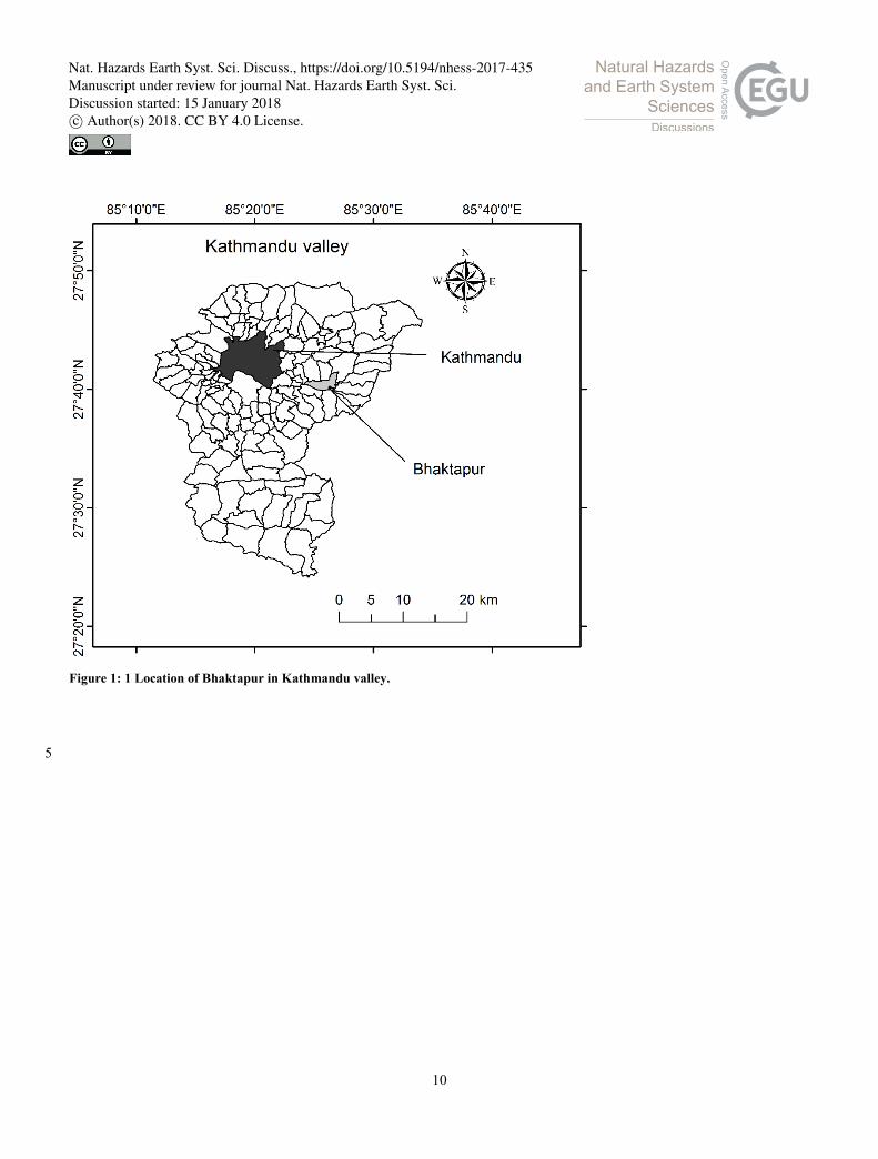
Bhaktapur is a densely populated medieval town situated 12 km east of Kathmandu (Fig. 1). Until 2014, nearly 18600 building
were constructed within 6.88 km2 area and more than 80% of the total buildings were the vernacular brick masonry ones.
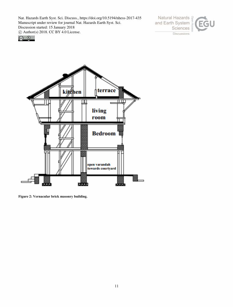
Vernacular Newari buildings are unreinforced brick masonry buildings usually having three to four stories (Fig. 2). A shallow 20
foundation of bricks is provided in vernacular buildings. The first story comprises large openings to run small businesses
whereas the upper stories constitute lesser opening percentage. Vernacular buildings are generally rectangular and constructed
usually in gently sloping terrain. The thickness of brick masonry wall varies between 250 and 600 mm (see Fig. 3). In the third
and fourth stories, timber posts are also provided and wooden staircase is provided for vertical transportation. As shown in
Fig. 2, first floor is used for commercial activities; second floor is used for bedrooms; third floor is used for living rooms; and 25
the fourth floor is used as kitchen. In general, box gable roof is provided in vernacular masonry buildings, meanwhile, roofing
material is dominantly the roof tiles. Upper stories are usually provided with depressed and projected windows whereas the
lower stories comprise dormer or lattice windows. Fig. 3 shows a typical section of vernacular brick masonry building that
comprises mud mortar, brick layer, wooden plank and timber beam. Two types of wall partitioning can be observed in
vernacular buildings: either throughout masonry wall or wooden planks guided one. 30
Nat. Hazards Earth Syst. Sci. Discuss., https://doi.org/10.5194/nhess-2017-435Manuscript under review for journal Nat. Hazards Earth Syst. Sci.Discussion started: 15 January 2018c© Author(s) 2018. CC BY 4.0 License.

3
3 Seismic performance of vernacular Newari buildings during major earthquakes
3.1 Bihar-Nepal earthquake
The 1934 Bihar-Nepal earthquake is the strongest earthquake (MW ~8.4) in the modern history of Nepal. The epicenter of the
earthquake was in eastern Nepal and the effect of earthquake was observed throughout Nepal and northern India. Rana (1935)
reported the focal depth to be ~24-40 miles taking into consideration of public opinion. Rana (1935) reported that the effective 5
shaking was of 2-3 minutes and whereas the total shaking was felt for around 8 minutes. Furthermore, Rana (1935) noted that
the shaking was initially horizontal and then circular. Vertical shaking was also reported to be dominant by Rana (1935) during
Bihar-Nepal earthquake. Rana (1935) estimated the ground peak ground velocity in the range of 285-345 cm/s, although this
estimation comes from Rana’s own experience, however, such figures depict strong ground shaking during the earthquake.
Although, the epicenter of the earthquake was nearly 150km east of Bhaktapur, severe damage was occurred in Bhaktapur. 10
Such intense damage was attributed to site characteristics of Bhaktapur (alluvial deposit), construction technology, building
population and vulnerability of building stocks. Reports of building damage due to Bihar-Nepal earthquake are presented in
the following section.
3.1.1 Reported building damage in Bhaktapur
In total, 6224 residential buildings were damaged due Bihar-Nepal earthquake (Rana, 1935). More than 177 heritage structures 15
were also damaged due to the earthquake. The most common failure mode was reported to be the combination of in plane and
out of plane mechanism as shown in Fig. 4a. Apart from this, poor binding among the masonry units can be observed in
damaged wall section. Fig. 4b depicts the collapse of heavy gable wall as contemporary practices were based on homogenous
walls throughout the building.
Rana (1935) reported that the damage range was between 40-100% for various settlements within the town and outlined the 20
causes of damage as: a) multistoried buildings; b) buildings with higher opening percentage; c) structural pounding in case of
row housing; d) buildings constructed with low quality bricks (unbaked ones) ; e) improper bonding between the brick units;
f) load concentration in the upper stories and gable; g) poor site selection and foundation problem (unleveled); h) buildings
undergone with incremental construction; i) projections; and j) lack of integrity between the orthogonal walls.
Pictures of damage taken by Rana (1935) confirm that the buildings in the corner of row housing settlements were damaged 25
more than the standalones. This may be due to combination of vulnerability as well as additional lateral load imposed by other
structures.
The description presented by Rana (1935) also considered some of the improvement measures for post-earthquake
reconstruction as: a) use well dried and proper dimension bricks with smooth finish for construction; b) Oil mixed and dried
bricks “Chiga: appa” is better than other brick types; c) do not construct more than a story with raw bricks; d) use light roofing; 30
e) limit the height of vernacular buildings to 51 ft.; f) mix cow dung for improved mortar quality; g) use timber posts rather
than brick pillars; h) avoid river banks, land plots beside the ponds for construction; i) provide timber band “Nas” in in masonry
Nat. Hazards Earth Syst. Sci. Discuss., https://doi.org/10.5194/nhess-2017-435Manuscript under review for journal Nat. Hazards Earth Syst. Sci.Discussion started: 15 January 2018c© Author(s) 2018. CC BY 4.0 License.

4
walls; j) reduce weight of gable portion; k) provide sufficient masonry wall in between the openings; l) lime as mortar is
superior than mud mortar or mud with cow dung; m) determine building height and foundation depth per the quality of
construction materials.
3.2 Udaypur earthquake
After the 1934 earthquake, Bhaktapur was hit by several moderate earthquakes until 1988, however, notable structural damage 5
was not reported. Udaypur earthquake (MW 6.8) occurred in 1988 ~150 km southeast of Kathmandu. During this earthquake,
Bhaktapur was the most affected town in Kathmandu valley. The Modified Mercalli Intensity (MMI) for Kathmandu valley
was assigned to be V and peak ground acceleration was estimated to be ~20-50 gals (Fujiwara et al., 1989). The maximum
MMI intensity for Bhaktapur was estimated ~7.40 whereas neighboring towns Kathmandu and Patan were assigned to 6.67
and 6.57 maximum intensity respectively by Fujiwara et al. (1989). Gupta (1988) and Fujiwara et al. (1989) reported that most 10
of the damaged buildings were the survivors of the 1934 earthquakes.
3.2.1 Reported building damage in Bhaktapur
During Udaypur earthquake 274 buildings collapsed and other 1477 buildings observed partial damage throughout Bhaktapur
district. Due to lack of statistical records in localized scale, exact scenario of damage distribution is not possible to outline;
however, the descriptions provided by Gupta (1988), Fujiwara et al. (1989) and Dixit (1991) suggest that the town of Bhaktapur 15
was the most affected. Fujiwara et al. (1989) has reported that the houses partly damaged during 1934 earthquake were used
without any repair and the damage was intense in such structures. The construction practices as highlighted by Gupta (1988)
and Fujiwara et al. (1989) reflect that there were no indications of the improved construction practice per the recommendations
of Rana (1935) after the 1934 earthquake. Gupta (1988) and Fujiwara et al. (1989) identified the causes of building damage
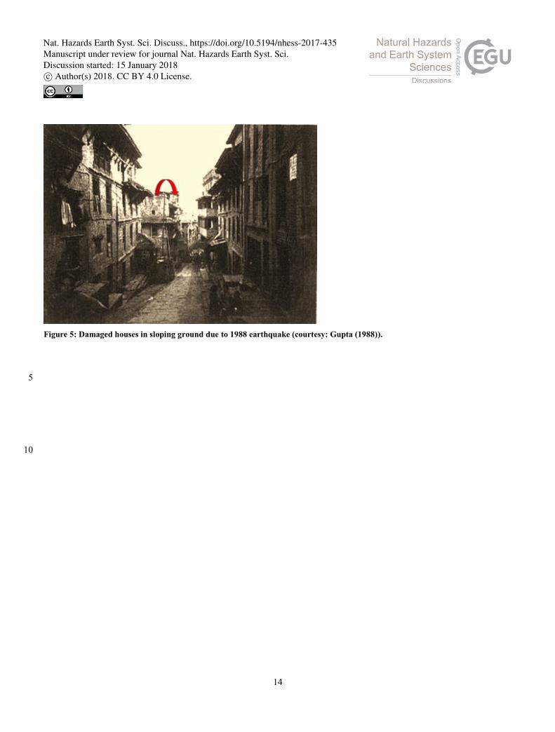
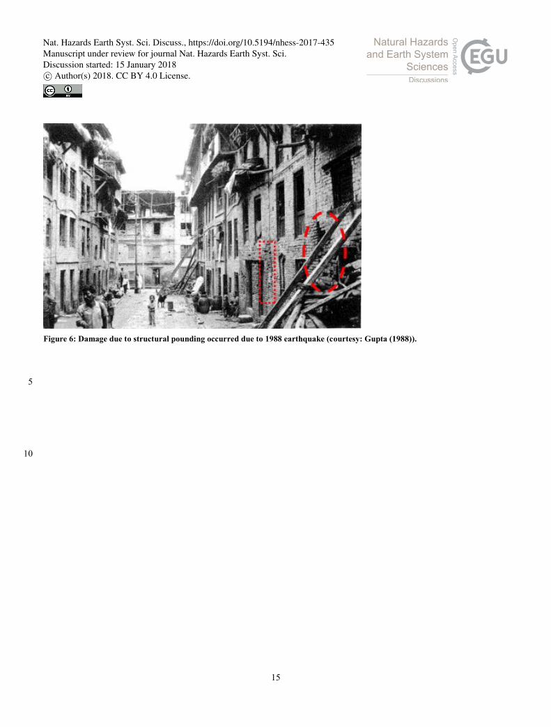
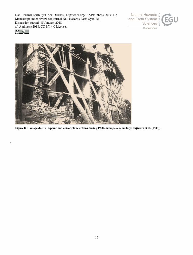
in Bhaktapur as: a) buildings situated in sloping ground (Fig. 5); b) building constructed using mud-mortar; c) buildings 20
constructed up to four to five stories in brick masonry without any earthquake resistant provision (Fig. 5); d) structural
pounding (Fig. 6); e) poor quality of construction material for foundation; f) poor mortar quality; g) separation of masonry
units due to shrinkage in mud-mortar; h) marginal construction in corner joints and joints occurring in between different walls
within the diaphragm; i) non-dried clay bricks used in walls; j) lack of diaphragm action due to improper timber joists; k)
heavy gable construction and roofing (Fig. 7); l) heavy masonry wall (thickness ~500 mm); m) in-plane and out-of-plane 25
mechanisms (Fig. 8); n) improper opening placement (Fig. 9); and o) cantilevered projections.
Following their field investigation, Fujiwara et al. (1989) recommended some measures for earthquake resistant constructions
as: a) lower the overall building weight by avoiding the brick topping on floor level and replacing the heavy roof by corrugated
iron sheets or thatch; b) restrain the gable wall along with the main structural walls below it so that a matchbox type
construction could be developed that assures better structural integrity; c) place horizontal bracing for roof and floor slabs and 30
also provide diagonal bracing at the corners; and d) improve mortar quality.
Nat. Hazards Earth Syst. Sci. Discuss., https://doi.org/10.5194/nhess-2017-435Manuscript under review for journal Nat. Hazards Earth Syst. Sci.Discussion started: 15 January 2018c© Author(s) 2018. CC BY 4.0 License.

5
3.3 Sikkim-Nepal border earthquake
The Sikkim-Nepal border earthquake (MW 6.9) affected primarily eastern Nepal but few cases of vernacular masonry damage
in Bhaktapur were observed during the field reconnaissance. The earthquake occurred ~270 km east of Kathmandu valley at a
focal depth of 19.7 km (USGS 2011).
During the field investigation, it was known that the damaged buildings were the ones already partially damaged due to 1988 5
Udyapur earthquake. Although the accelerometric records in Kathmandu valley show low peak ground acceleration (~0.05g),
some of the buildings in Bhaktapur sustained partial collapse and some others sustained partial damage. Interestingly, some
of the already bulged buildings due to the 1988 Udaypur earthquake remained unaffected in some locations of Bhaktapur.
Notably, two cases of out of plane wall collapse were observed (Fig. 10a) in Bhaktapur. In addition, one case of structural
pounding was noted probably due to sharp variation in dynamic properties among the adjoin buildings (Fig. 10b). Damages in 10
heavy gable wall (Fig. 11a), cracks on masonry walls especially at corner region (Fig. 11b), and damage in heavy roof (Fig.
11c) were identified other observed damage modes during the field reconnaissance. Since1934, the construction strategy was
not found to be changed as the similar failure modes and construction materials and technology were observed during field
reconnaissance.
3.4 Gorkha earthquake 15
The 2015 Gorkha earthquake (MW 7.8) affected the ancient Bhaktapur town heavily that can be roughly compared to the
damage occurred during 1934 earthquake. The epicenter of Gorkha earthquake was located ~78 km N-NE of Kathmandu
valley in Barpak village of Gorkha district. Several factors like local amplification and construction technology responsible
for structural damage and the accounts of building damage in regional scale are presented by Gautam et al. (2016) and Gautam
and Chaulagain (2016). In the case of Bhaktapur, almost 80% building stocks were the vernacular Newari houses and most of 20
remaining buildings were the substandard RC buildings (for details see: Chaulagain et al. (2013). During Gorkha earthquake,
relatively lower value of PGA and short duration of shaking may have altered the damage scenario and hence previous loss
estimation models depicted by Chaulagain et al. (2016) was not able to represent the actual damage scenario.
3.4.1 Report of building damage in Bhaktapur
Although the intensity of earthquake in Kathmandu valley was generally VIII, some areas of Bhaktapur like; Golmadhi, 25
Suryamadhi, Jela, Byasi were destroyed; that leads in greater than VIII intensity. In the follwoign section of the manuscript,
we have assigned IX intensity for Bhaktapur to derive the fragility functions. local scale. Fig. 12 depicts the major collapse
locations within Bhaktapur; destroyed settlements are highlighted by large red bubbles. Apart from this, slight, minor and
heavy damages were observed in all parts of the town. The major damage locations were towards the eastern fringe of the town
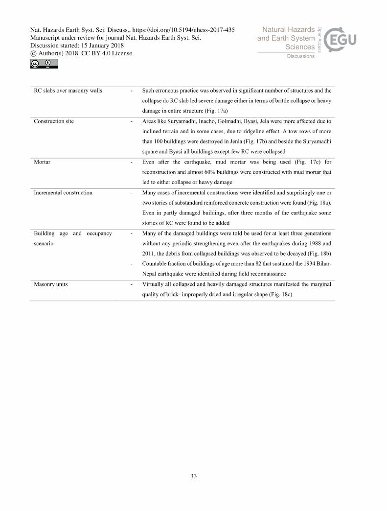
and the settlements located on the sloping ground. The summary of component-wise failure modes is presented in Table 1. 30
Nat. Hazards Earth Syst. Sci. Discuss., https://doi.org/10.5194/nhess-2017-435Manuscript under review for journal Nat. Hazards Earth Syst. Sci.Discussion started: 15 January 2018c© Author(s) 2018. CC BY 4.0 License.

6
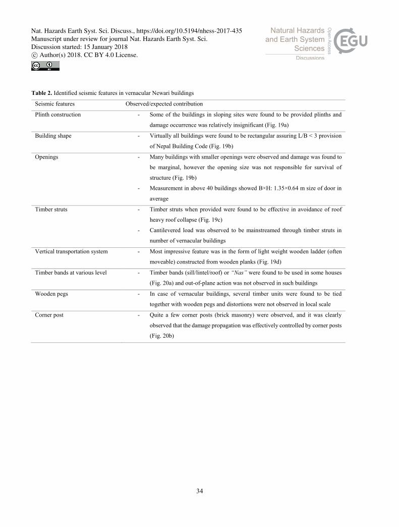
3.4.2 Seismic features in vernacular Newari buildings
During field investigation, apart from the widespread damage, significant survival cases were also identified. We observed
that the buildings consisting some specific features were either lowly damaged or undamaged when compared to the buildings
without such features. We observed that, the features highlighted in Table 2 effectively contributed in collapse prevention and
in many cases life safety should have been facilitated by such components too. Table 2 outlines the identified seismic features 5
in vernacular Newari buildings of Bhaktapur.
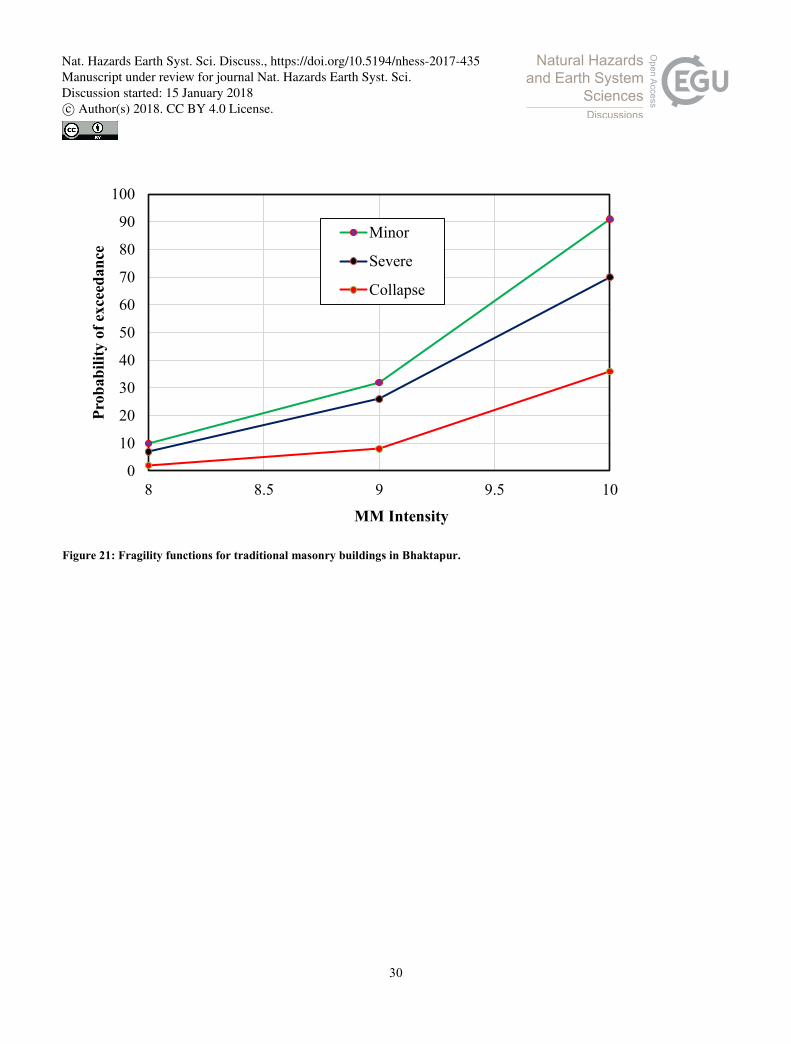
4 Construction of DPM and fragility functions
Seismic vulnerability of buildings is either presented in terms of damage probability matrices (DPM) or fragility functions
(Elnashai and Di Sarno, 2000). Many researchers have formulated fragility functions for buildings worldwide using either
analytical (e.g. Hassan and Sozen, 1997; Erberik and Elnashai, 2004; Rota et al., 2010; Parisi and Sabella, 2017), empirical 10
(e.g. Sabetta et al., 1998; Yamazaki and Murao, 2000; Rossetto and Elnashai, 2003; Gautam, 2017), hybrid (e.g. Kappos et al.
2006; Kappos and Panagopoulos, 2010) or expert opinion (e.g. ATC, 1985; ATC, 1996) approaches. To the best of authors’
knowledge, fragility functions for traditional Newari buildings do not exist, however their vulnerability is important due to
their large population in major urban centers of Kathmandu valley. To address the lack of vulnerability functions or DPM, we
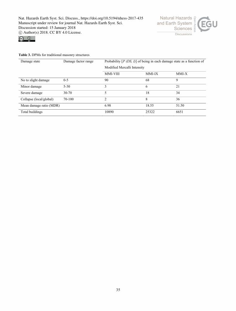
have created DPM as well fragility functions using the database of 1934, 1988 and 2015 earthquakes. To create the DPMs, we 15
first defined the mean damage ratio (MDR) for three intensity levels. The mean damage ratio (MDR) at given intensity level
(I) can be calculated as:
𝑀𝐷𝑅(𝐼) = Σ𝐷𝑆 𝑃(𝐷𝑆, 𝐼)×𝐶𝐷𝑅(𝐷𝑆), (1)
Where MDR(I) is mean damage ratio at given intensity; P (DS, I) is the damage state probability of defined building type; and
CDR(DS) indicates central damage ratio corresponding to the damage state DS. The damage state probability P (DS, I) can 20
be calculated as below:
𝑃 (𝐷𝑆, 𝐼) =𝑁(𝐷𝑆, 𝐼)
𝑁(𝐼), (2)
Where 𝑁(𝐷𝑆, 𝐼)denotes the number of buildings in damage state DS; and 𝑁(𝐼) indicates the total number of buildings
subjected to the earthquake event. DPMs for VIII, IX and X intensity levels were derived based on the damage data available
from historical accounts. The DPMs for traditional masonry buildings is presented in Table 3. The DPMs were subsequently 25
converted into fragility functions by as shown in Fig. 21.
The database was taken from Rana (1935), Gupta (1988), Fujiwara et al. (1989), NPC (2015) and some news outlets. To create
fragility functions, we considered peak ground velocity (PGV) as intensity measure (IM) that was estimated from the Modified
Mercalli Intensity (IMM) using the correlation proposed by Wald et al. (1999) as:
𝐼𝑀𝑀 = 3.47 log(𝑃𝐺𝑉) + 2.35, (3) 30
Nat. Hazards Earth Syst. Sci. Discuss., https://doi.org/10.5194/nhess-2017-435Manuscript under review for journal Nat. Hazards Earth Syst. Sci.Discussion started: 15 January 2018c© Author(s) 2018. CC BY 4.0 License.

7
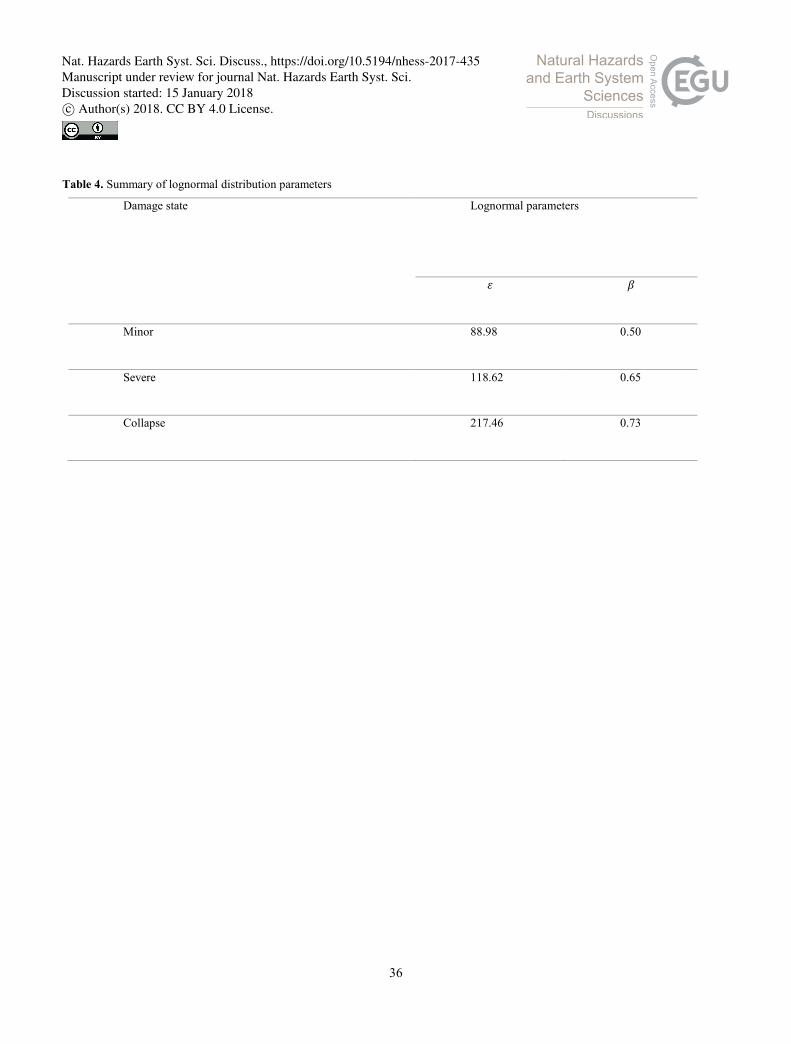
The estimated peak ground velocities from each of the earthquake were employed to calculate the lognormal distribution
parameters as intensity measures (IMs). Several previous studies confirm the lognormal distribution as the representative
statistical distribution (e.g. Porter and Kiremidjian, 2001; Beck et al., 2002; Pagni and Lowes, 2006), accordingly we use the
lognormal distribution in this study. Two-parameter lognormal cumulative distribution function used to define the fragility
functions can be written as: 5
𝐹(𝐶|𝐼𝑀 = 𝑥) = 𝛷 (ln (𝑥/𝜀)
𝛽), (4)
Where 𝐹(𝐶|𝐼𝑀 = 𝑥) indicates the probability that a ground motion with 𝐼𝑀 = 𝑥 will cause the given damage state (minor,
severe, collapse); 𝛷(·) is the standard normal cumulative distribution function; 𝜀 is the median of the fragility function; and 𝛽
is the logarithmic standard deviation. A summary of the estimated lognormal distribution parameters for minor, severe and
collapse damage states is also presented in Table 4 below. Fragility functions for three damage states are derived from the 10
damage data of 1934, 1988 and 2015 earthquakes as shown in Fig. 22.
5 Construction of DPM and fragility functions
Our observations and forensic analysis has led us to conclude that the vernacular Newari buildings are likely to be severely
damaged in the case of strong to major earthquakes (MMI≥VIII). Due to lack of periodic strengthening and repairs after the
earthquakes and unrelenting use, vulnerability of vernacular buildings in Bhaktapur is very high that may lead to collapse even 15
at moderate shaking. We have presented the damage modes from four earthquakes (1934, 1988, 2011 and 2015), and forensic
interpretations confirm that there is not substantial change in the traditional construction practices between 1934 and 2015.
The damage probability matrices and fragility functions created from the damage data depict that the collapse damage state is
more likely than any other in the case of strong to major earthquakes and that may drastically increase the fatality rate. The
upshot of this is the possibility that the damage in Bhaktapur will be greater than any other areas if the vulnerable structures 20
are not strengthened immediately. This research has underlined the importance of identification of local seismic features that
could effectively downscale the building collapse. The most important limitation of this research lies in the use of empirical
database to create fragility functions, so future studies should develop analytical models to create analytical fragility functions.
This is the first step towards enhancing the understanding of seismic vulnerability of vernacular Newari buildings and further
work needs to be done to establish possible low cost strengthening solutions as well as retrofitting strategies. 25
Acknowledgments
Authors are grateful to Ganesh Kumar Bhattarai, Raghu N Prajapati, Jastara Koju, Dhira Phadera, Bharat Chandra Hada, and
many other local from Bhaktapur who assisted in collection of information from various sources.
Nat. Hazards Earth Syst. Sci. Discuss., https://doi.org/10.5194/nhess-2017-435Manuscript under review for journal Nat. Hazards Earth Syst. Sci.Discussion started: 15 January 2018c© Author(s) 2018. CC BY 4.0 License.
8
References
ATC (Applied Technology Council): Earthquake damage evaluation data for California, ATC-13, Applied Technology
Council, California, 1985.
ATC (Applied Technology Council): Seismic evaluation and retrofit of concrete buildings, ATC-40, Applied Technology
Council, California, 1996. 5
Beck, J.L., Porter, K.A., Shaikhutdinov, R., Au, S.K., Mizukoshi, K., Miyamura, M., Ishida, H., Moroi, T., Tsukada, Y., and
Masuda, M.: Impact of seismic risk on lifetime property values, final report, CUREE, Richmond, CA, 2002.
Bilham, R.: Location and magnitude of the 1833 Nepal earthquake and its relation to the rupture zones of contiguous great
Himalayan earthquakes, Current Science, 69(2), 155-187, 1995.
Chaulagain, H., Rodrigues, H., Jara, J., Spacone, E., and Varum, H.: Seismic response of current RC buildings in Nepal: 10
comparative analysis of different design/construction, Engineering Structures, 49:284-294, 2013.
Chaulgain, H., Rodrigues, H., Silva, V., Spacone, E., and Varum, H.: Earthquake loss estimation for the Kathmandu valley,
Bulletin of Earthquake Engineering, 14, 59-88, 2016.
Dixit, A.M.: Geological effects and intensity distribution of the Udaypur (Nepal) earthquake of August 20, 1988, Journal of
Nepal Geological Society, 7:1–17, 1991. 15
Elnashai, A.S., and Di Sarno, L.: Fundamentals of earthquake engineering, Wiley and Sons, West Sussex, United Kindgodm,
2000.
Erberik, M.A., and Elnashai, A.S.: Fragility analysis of flat‐slab structures, Engineering Structures, 26(7), 937–948, 2004.
Fujiwara, T., Sato, T., Murakami, H.O., and Kubo, T.: Reconnaissance report on the 21 August 1988 earthquake in the Nepal-
India border region, Research Report on Natural Disasters, Japanese Group for the Study of Natural Disaster Science, 20
Tokyo, 1989.
Gautam, D.: On seismic vulnerability of highway bridges in Nepal: 1988 Udaypur earthquake (MW 6.8) revisited, Soil
Dynamics and Earthquake Engineering, 99, 168-171, 2017.
Gautam, D., Rodrigues, H., Bhetwal, K.K., Neupane, P., and Sanada, Y.: Common structural and construction
deficiencies of Nepalese buildings, Innovative Infrastructure Solutions, 1: 1. doi:10.1007/s41062 -016-0001-3, 25
2016.
Gautam, D., and Chaulagain, H.: Structural performance and associated lessons to be learned from world earthquakes in
Nepal after 25 April 2015 (MW 7.8) Gorkha earthquake, Engineering Failure Analysis, 68, 222-243, 2016.
Gupta, S.P.: Eastern Nepal earthquake 21 August 1988, damage and recommendations for repairs and reconstruction, Asian
Disaster Preparedness Center, Bangkok, 1988. 30
Hassan, A.F., and Sozen, M.A.: Seismic vulnerability assessment of low‐rise buildings in regions with infrequent earthquakes,
ACI Structural Journal, 94(1), 31–39, 1997.
Nat. Hazards Earth Syst. Sci. Discuss., https://doi.org/10.5194/nhess-2017-435Manuscript under review for journal Nat. Hazards Earth Syst. Sci.Discussion started: 15 January 2018c© Author(s) 2018. CC BY 4.0 License.
9
Kappos, A.J., Panagopoulos, G., Panagiotopoulos, C., and Penelis, G.: A hybrid method for the vulnerability assessment of
R/C and URM buildings, Bulletin of Earthquake Engineering, 4(4), 391-413, 2006.
Kappos, A.J., and Panagopoulos, G.: Fragility curves for reinforced concrete buildings in Greece, Structures and Infrastructure
Engineering, 6(1-2), 39-53, 2010.
NPC (National Planning Commission): Post Disaster Need Assessment Vol. A and B. Kathmandu: Government of Nepal; 5
2015.
Pagni, C.A., and Lowes, L.N.: Fragility functions for older reinforced concrete beam-column joints, Earthquake Spectra, 22,
215-238, 2006.
Parisi, F., and Sabella, G.: Flow type landslide fragility of reinforced concrete framed buildings, Engineering Structures, 131,
28-43, 2017. 10
Porter, K.A., and Kiremidjian, A.S.: Assembly-based vulnerability and its uses in seismic performance evaluation and risk-
management decision-making, Report No. 139, John A. Blume Earthquake Engineering Center, Stanford, CA, 2001.
Rana, B.S.J.B.: The great earthquake of Nepal (Nepalko Mahabhukampa) [in Nepali], Jorganesh Press, Kathmandu, 1935.
Rossetto, T., and Elnashai, A.S.: Derivation of vulnerability functions for European‐type RC structures based on observational
data, Engineering Structures. 25(10), 1241–1263, 2003. 15
Rota, M., Penna, A., and Magenes, G.: A methodology for deriving analytical fragility curves for masonry buildings based on
stochastic nonlinear analyses, Engineering Structures, 32(5), 1312–1323, 2010.
Sabetta, F., Goretti, A., and Lucantoni, A.: Empirical fragility curves from damage surveys and estimated strong ground
motion, Proceedings of the 11th European Conference on Earthquake Engineering, Paris, France, pp. 1-11, 1998.
USGS (United States Geological Survey). 2011. http://earthquake.usgs.gov/earthquakes/eqinthenews/2011/usc0005wg6/ 20
Wald, D.J., Quitoriano, V., Heaton, T.H., and Kanamori, H.: Relationships between peak ground acceleration, peak ground
velocity, and Modified Mercalli Intensity in California, Earthquake Spectra, 15(3), 557-564, 1999.
Yamazaki, F., and Murao, O.: Vulnerability functions for Japanese buildings based on damage data from the 1995 Kobe
earthquake, Implication of Recent Earthquakes on Seismic Risk, Series on Innovation and Construction, Imperial
College Press, vol. 2, pp. 91–102, 2000. 25
Nat. Hazards Earth Syst. Sci. Discuss., https://doi.org/10.5194/nhess-2017-435Manuscript under review for journal Nat. Hazards Earth Syst. Sci.Discussion started: 15 January 2018c© Author(s) 2018. CC BY 4.0 License.
10
Figure 1: 1 Location of Bhaktapur in Kathmandu valley.
5
Nat. Hazards Earth Syst. Sci. Discuss., https://doi.org/10.5194/nhess-2017-435Manuscript under review for journal Nat. Hazards Earth Syst. Sci.Discussion started: 15 January 2018c© Author(s) 2018. CC BY 4.0 License.
11
Figure 2: Vernacular brick masonry building.
Nat. Hazards Earth Syst. Sci. Discuss., https://doi.org/10.5194/nhess-2017-435Manuscript under review for journal Nat. Hazards Earth Syst. Sci.Discussion started: 15 January 2018c© Author(s) 2018. CC BY 4.0 License.

12
Figure 3: A section of the masonry wall.
5
10
Nat. Hazards Earth Syst. Sci. Discuss., https://doi.org/10.5194/nhess-2017-435Manuscript under review for journal Nat. Hazards Earth Syst. Sci.Discussion started: 15 January 2018c© Author(s) 2018. CC BY 4.0 License.

13
Figure 4: (a) Combined in-plane and out-of-plane failure in masonry walls (courtesy: Rana (1935)) (b) Collapse occurred in the
upper story due to mass concentration (courtesy: Rana (1935)).
5
10
Nat. Hazards Earth Syst. Sci. Discuss., https://doi.org/10.5194/nhess-2017-435Manuscript under review for journal Nat. Hazards Earth Syst. Sci.Discussion started: 15 January 2018c© Author(s) 2018. CC BY 4.0 License.
14
Figure 5: Damaged houses in sloping ground due to 1988 earthquake (courtesy: Gupta (1988)).
5
10
Nat. Hazards Earth Syst. Sci. Discuss., https://doi.org/10.5194/nhess-2017-435Manuscript under review for journal Nat. Hazards Earth Syst. Sci.Discussion started: 15 January 2018c© Author(s) 2018. CC BY 4.0 License.
15
Figure 6: Damage due to structural pounding occurred due to 1988 earthquake (courtesy: Gupta (1988)).
5
10
Nat. Hazards Earth Syst. Sci. Discuss., https://doi.org/10.5194/nhess-2017-435Manuscript under review for journal Nat. Hazards Earth Syst. Sci.Discussion started: 15 January 2018c© Author(s) 2018. CC BY 4.0 License.

16
Figure 7: Gable collapse reported by Fujiwara et al. (1989) during 1988 earthquake.
5
10
Nat. Hazards Earth Syst. Sci. Discuss., https://doi.org/10.5194/nhess-2017-435Manuscript under review for journal Nat. Hazards Earth Syst. Sci.Discussion started: 15 January 2018c© Author(s) 2018. CC BY 4.0 License.
17
Figure 8: Damage due to in-plane and out-of-plane actions during 1988 earthquake (courtesy: Fujiwara et al. (1989)).
5
Nat. Hazards Earth Syst. Sci. Discuss., https://doi.org/10.5194/nhess-2017-435Manuscript under review for journal Nat. Hazards Earth Syst. Sci.Discussion started: 15 January 2018c© Author(s) 2018. CC BY 4.0 License.

18
Figure 9: Bulging of wall observed above the doors due to 1988 earthquake (courtesy: Fujiwara et al. (1989)).
Nat. Hazards Earth Syst. Sci. Discuss., https://doi.org/10.5194/nhess-2017-435Manuscript under review for journal Nat. Hazards Earth Syst. Sci.Discussion started: 15 January 2018c© Author(s) 2018. CC BY 4.0 License.
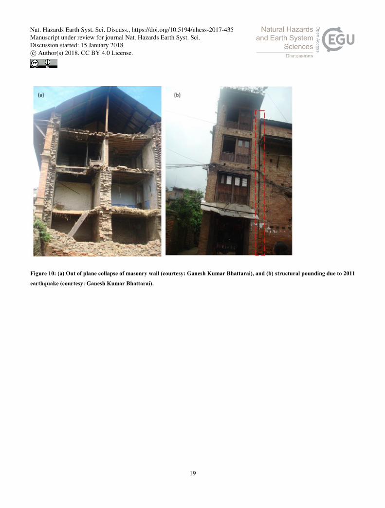
19
Figure 10: (a) Out of plane collapse of masonry wall (courtesy: Ganesh Kumar Bhattarai), and (b) structural pounding due to 2011
earthquake (courtesy: Ganesh Kumar Bhattarai).
Nat. Hazards Earth Syst. Sci. Discuss., https://doi.org/10.5194/nhess-2017-435Manuscript under review for journal Nat. Hazards Earth Syst. Sci.Discussion started: 15 January 2018c© Author(s) 2018. CC BY 4.0 License.

20
Figure 11: (a) Gable collapse occurred in two adjoining buildings (courtesy: Ganesh Kumar Bhattarai), (b) cracks propagated
towards the corners (courtesy: Ganesh Kumar Bhattarai), (c) heavy roof collapse and out of plane failure of brick masonry wall
occurred due to 2011 earthquake (courtesy: Ganesh Kumar Bhattarai).
Nat. Hazards Earth Syst. Sci. Discuss., https://doi.org/10.5194/nhess-2017-435Manuscript under review for journal Nat. Hazards Earth Syst. Sci.Discussion started: 15 January 2018c© Author(s) 2018. CC BY 4.0 License.

21
Figure 12: Major building collapse areas within the ancient settlement of Bhaktapur city (modified from:
https://www.google.com/earth/).
Nat. Hazards Earth Syst. Sci. Discuss., https://doi.org/10.5194/nhess-2017-435Manuscript under review for journal Nat. Hazards Earth Syst. Sci.Discussion started: 15 January 2018c© Author(s) 2018. CC BY 4.0 License.

22
Figure 13: (a) Minor damage on roof (b) out of plane collapse of walls (c) gable collapse occurred due to Gorkha earthquake
sequence.
Nat. Hazards Earth Syst. Sci. Discuss., https://doi.org/10.5194/nhess-2017-435Manuscript under review for journal Nat. Hazards Earth Syst. Sci.Discussion started: 15 January 2018c© Author(s) 2018. CC BY 4.0 License.
23
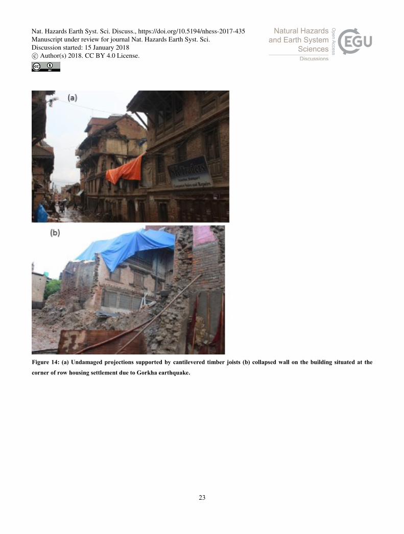
Figure 14: (a) Undamaged projections supported by cantilevered timber joists (b) collapsed wall on the building situated at the
corner of row housing settlement due to Gorkha earthquake.
Nat. Hazards Earth Syst. Sci. Discuss., https://doi.org/10.5194/nhess-2017-435Manuscript under review for journal Nat. Hazards Earth Syst. Sci.Discussion started: 15 January 2018c© Author(s) 2018. CC BY 4.0 License.
24
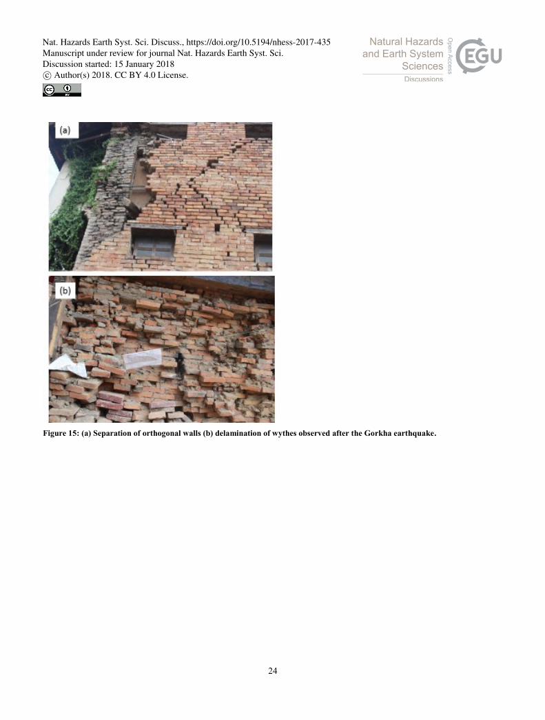
Figure 15: (a) Separation of orthogonal walls (b) delamination of wythes observed after the Gorkha earthquake.
Nat. Hazards Earth Syst. Sci. Discuss., https://doi.org/10.5194/nhess-2017-435Manuscript under review for journal Nat. Hazards Earth Syst. Sci.Discussion started: 15 January 2018c© Author(s) 2018. CC BY 4.0 License.

25
Figure 16: (a) Reentrant corner damage along with structural pounding (b) separated masonry units and the mud-mortar (c)
structural pounding led separation due to variation in dynamic characteristic of jointed buildings observed during Gorkha
earthquake.
Nat. Hazards Earth Syst. Sci. Discuss., https://doi.org/10.5194/nhess-2017-435Manuscript under review for journal Nat. Hazards Earth Syst. Sci.Discussion started: 15 January 2018c© Author(s) 2018. CC BY 4.0 License.
26
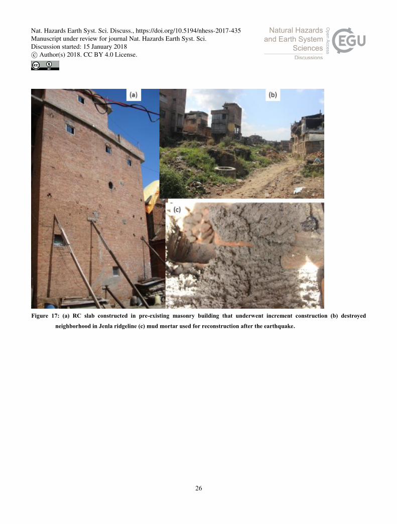
Figure 17: (a) RC slab constructed in pre-existing masonry building that underwent increment construction (b) destroyed
neighborhood in Jenla ridgeline (c) mud mortar used for reconstruction after the earthquake.
Nat. Hazards Earth Syst. Sci. Discuss., https://doi.org/10.5194/nhess-2017-435Manuscript under review for journal Nat. Hazards Earth Syst. Sci.Discussion started: 15 January 2018c© Author(s) 2018. CC BY 4.0 License.

27
Figure 18: (a) Building with one masonry and next RC incremental construction above the vernacular masonry construction (b)
debris reflects decay of construction material (c) irregular size and poor quality of bricks used for structural wall.
Nat. Hazards Earth Syst. Sci. Discuss., https://doi.org/10.5194/nhess-2017-435Manuscript under review for journal Nat. Hazards Earth Syst. Sci.Discussion started: 15 January 2018c© Author(s) 2018. CC BY 4.0 License.

28
Figure 19: Identified seismic features: (a) plinth constructed in sloping ground (b) symmetrical building practice (c) timber struts
for mainstreaming cantilevered load (d) wooden ladder.
Nat. Hazards Earth Syst. Sci. Discuss., https://doi.org/10.5194/nhess-2017-435Manuscript under review for journal Nat. Hazards Earth Syst. Sci.Discussion started: 15 January 2018c© Author(s) 2018. CC BY 4.0 License.
29
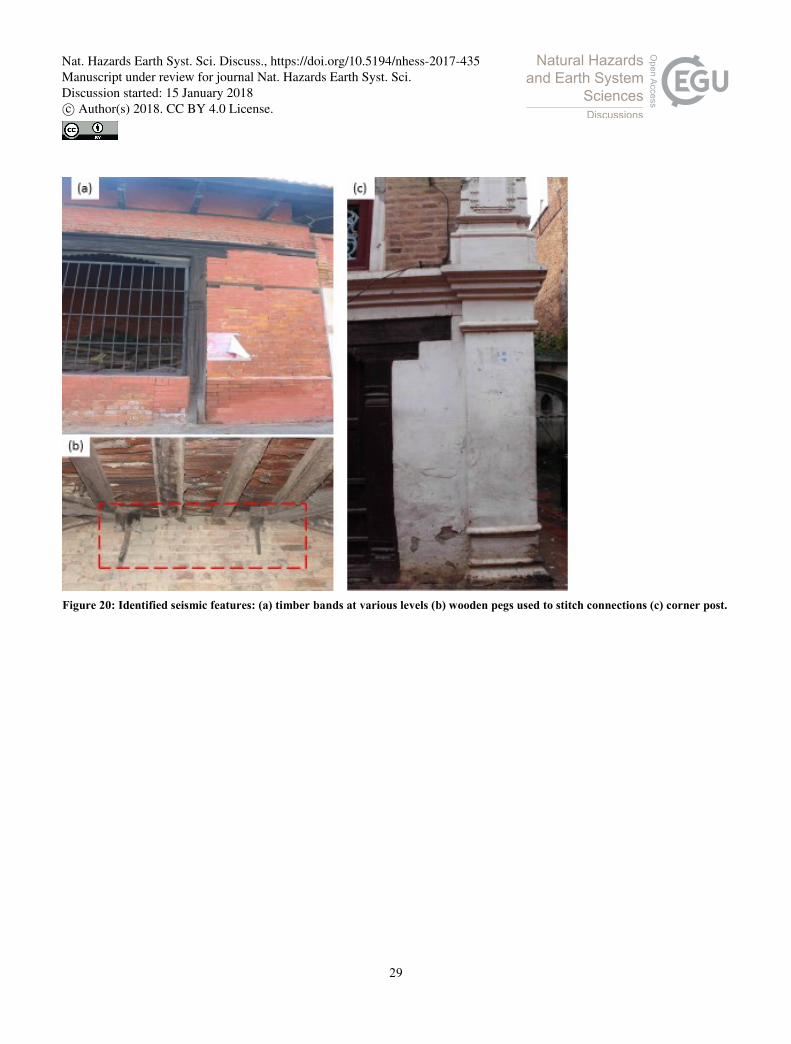
Figure 20: Identified seismic features: (a) timber bands at various levels (b) wooden pegs used to stitch connections (c) corner post.
Nat. Hazards Earth Syst. Sci. Discuss., https://doi.org/10.5194/nhess-2017-435Manuscript under review for journal Nat. Hazards Earth Syst. Sci.Discussion started: 15 January 2018c© Author(s) 2018. CC BY 4.0 License.
30
Figure 21: Fragility functions for traditional masonry buildings in Bhaktapur.
0
10
20
30
40
50
60
70
80
90
100
8 8.5 9 9.5 10
Pro
ba
bil
ity
of
exce
eda
nce
MM Intensity
Minor
Severe
Collapse
Nat. Hazards Earth Syst. Sci. Discuss., https://doi.org/10.5194/nhess-2017-435Manuscript under review for journal Nat. Hazards Earth Syst. Sci.Discussion started: 15 January 2018c© Author(s) 2018. CC BY 4.0 License.

31
Figure 22: Fragility functions for traditional masonry buildings in Bhaktapur.
0
0.1
0.2
0.3
0.4
0.5
0.6
0.7
0.8
0.9
1
0 100 200 300 400 500
Pro
bab
ilit
y o
f ex
ceed
ence
Velocity (cm/s)
Minor
Severe
Collapse
Nat. Hazards Earth Syst. Sci. Discuss., https://doi.org/10.5194/nhess-2017-435Manuscript under review for journal Nat. Hazards Earth Syst. Sci.Discussion started: 15 January 2018c© Author(s) 2018. CC BY 4.0 License.

32
Table 1. Building element/aspect based damage scenario in Bhaktapur during Gorkha earthquake
Damage element/aspect Damage scenario
Roof - Heavy roofs constructed using roof tiles were suffered in terms partial roof
collapse (Fig. 13a)
- Galvanized iron sheets performed well
Gable wall - Out of plane failure was commonly observed (Fig. 13b)
- Majority of the buildings were lacking proper connection between gable and the
masonry wall (Fig. 13c)
Projections - Wooden projections (various forms of windows) performed well (Fig. 14a)
Wall - Out of plane failure was observed as the most prevalent failure mechanism (Fig.
13c)
- Walls on the edge of the settlement suffered progressive collapse in out-of-plane
direction (Fig. 14b)
- Out of plane collapse of heavy wall constructed in upper stories (Fig. 13c)
- Walls were separated due to lack of proper connection and binding between
orthogonal walls as well as the structural and partition walls (Fig. 15a)
- Veneered partition walls performed better than the heavy brick masonry partitions
- Few cases of in-plane wall failures were observed in the buildings having many
openings and relatively larger in size
- Delamination of wythes was observed in some cases (Fig. 15b)
Corner - Reentrant corners were bulged out and large cracks were damaged in the
interaction zone (Fig. 16a)
- Corners were constructed without any special provisions
- Mud mortar was found to be suffered from shrinkage and throughout the
structural system, brick units were observed to be remaining in isolation marring
the structural integrity (Fig. 16b)
Structural pounding - Due to row housing system and intermediate modifications (reconstruction) and
due to high variation in dynamic properties of adjoining structures, many cases
of structural pounding led damaged were observed (Fig. 16c)
- Sometimes single building was found to be separated exactly into two halves and
partial reconstruction done, leading to damage in the remaining portion of
building. Change in slenderness ratio due to division of single building was also
observed in many buildings.
Ground floor - For commercial purpose, usually ground floor was not found to be provided with
structural wall rather shutters (wooden/iron) were prevalent and such buildings
with more height were observed to be damaged (Fig. 16c)
Nat. Hazards Earth Syst. Sci. Discuss., https://doi.org/10.5194/nhess-2017-435Manuscript under review for journal Nat. Hazards Earth Syst. Sci.Discussion started: 15 January 2018c© Author(s) 2018. CC BY 4.0 License.
33
RC slabs over masonry walls - Such erroneous practice was observed in significant number of structures and the
collapse do RC slab led severe damage either in terms of brittle collapse or heavy
damage in entire structure (Fig. 17a)
Construction site - Areas like Suryamadhi, Inacho, Golmadhi, Byasi, Jela were more affected due to
inclined terrain and in some cases, due to ridgeline effect. A tow rows of more
than 100 buildings were destroyed in Jenla (Fig. 17b) and beside the Suryamadhi
square and Byasi all buildings except few RC were collapsed
Mortar - Even after the earthquake, mud mortar was being used (Fig. 17c) for
reconstruction and almost 60% buildings were constructed with mud mortar that
led to either collapse or heavy damage
Incremental construction - Many cases of incremental constructions were identified and surprisingly one or
two stories of substandard reinforced concrete construction were found (Fig. 18a).
Even in partly damaged buildings, after three months of the earthquake some
stories of RC were found to be added
Building age and occupancy
scenario
- Many of the damaged buildings were told be used for at least three generations
without any periodic strengthening even after the earthquakes during 1988 and
2011, the debris from collapsed buildings was observed to be decayed (Fig. 18b)
- Countable fraction of buildings of age more than 82 that sustained the 1934 Bihar-
Nepal earthquake were identified during field reconnaissance
Masonry units - Virtually all collapsed and heavily damaged structures manifested the marginal
quality of brick- improperly dried and irregular shape (Fig. 18c)
Nat. Hazards Earth Syst. Sci. Discuss., https://doi.org/10.5194/nhess-2017-435Manuscript under review for journal Nat. Hazards Earth Syst. Sci.Discussion started: 15 January 2018c© Author(s) 2018. CC BY 4.0 License.
34
Table 2. Identified seismic features in vernacular Newari buildings
Seismic features Observed/expected contribution
Plinth construction - Some of the buildings in sloping sites were found to be provided plinths and
damage occurrence was relatively insignificant (Fig. 19a)
Building shape - Virtually all buildings were found to be rectangular assuring L/B < 3 provision
of Nepal Building Code (Fig. 19b)
Openings - Many buildings with smaller openings were observed and damage was found to
be marginal, however the opening size was not responsible for survival of
structure (Fig. 19b)
- Measurement in above 40 buildings showed B×H: 1.35×0.64 m size of door in
average
Timber struts - Timber struts when provided were found to be effective in avoidance of roof
heavy roof collapse (Fig. 19c)
- Cantilevered load was observed to be mainstreamed through timber struts in
number of vernacular buildings
Vertical transportation system - Most impressive feature was in the form of light weight wooden ladder (often
moveable) constructed from wooden planks (Fig. 19d)
Timber bands at various level - Timber bands (sill/lintel/roof) or “Nas” were found to be used in some houses
(Fig. 20a) and out-of-plane action was not observed in such buildings
Wooden pegs - In case of vernacular buildings, several timber units were found to be tied
together with wooden pegs and distortions were not observed in local scale
Corner post - Quite a few corner posts (brick masonry) were observed, and it was clearly
observed that the damage propagation was effectively controlled by corner posts
(Fig. 20b)
Nat. Hazards Earth Syst. Sci. Discuss., https://doi.org/10.5194/nhess-2017-435Manuscript under review for journal Nat. Hazards Earth Syst. Sci.Discussion started: 15 January 2018c© Author(s) 2018. CC BY 4.0 License.
35
Table 3. DPMs for traditional masonry structures
Damage state Damage factor range Probability [P (DS, I)] of being in each damage state as a function of
Modified Mercalli Intensity
MMI-VIII MMI-IX MMI-X
No to slight damage 0-5 90 68 9
Minor damage 5-30 3 6 21
Severe damage 30-70 5 18 34
Collapse (local/global) 70-100 2 8 36
Mean damage ratio (MDR) 6.98 18.55 51.50
Total buildings 10890 25322 6651
Nat. Hazards Earth Syst. Sci. Discuss., https://doi.org/10.5194/nhess-2017-435Manuscript under review for journal Nat. Hazards Earth Syst. Sci.Discussion started: 15 January 2018c© Author(s) 2018. CC BY 4.0 License.
36
Table 4. Summary of lognormal distribution parameters
Damage state Lognormal parameters
𝜀 𝛽
Minor 88.98 0.50
Severe 118.62 0.65
Collapse 217.46 0.73
Nat. Hazards Earth Syst. Sci. Discuss., https://doi.org/10.5194/nhess-2017-435Manuscript under review for journal Nat. Hazards Earth Syst. Sci.Discussion started: 15 January 2018c© Author(s) 2018. CC BY 4.0 License.