seismic hazard of egypt -...
TRANSCRIPT

Originally published as: El-Sayed, A., Wahlström, R., Kulhánek, O. (1994): Seismic hazard of Egypt. - Natural Hazards, 10, 3, 247-259.

Natural Hazards 10: 247-259, 1994. 247 © 1994 Kluwer Academic Publishers. Printed in the Netherlands.
Seismic Hazard of Egypt
A. E L - S A Y E D , R. W A H L S T R O M , and O. KULHA, NEK Seismological Department, Uppsala University, Box 2101, S-750 02 Uppsala, Sweden
(Received: 1 June 1993)
Abstract. Earthquake hazard parameters such as maximum expected magnitude, Mmax, annual activity rate, A, and b value of the Gutenberg-Richter relation have been evaluated for two regions of Egypt. The applied maximum likelihood method permits the combination of both historical and instrumental data. The catalogue used covers earthquakes with magnitude >3 from the time interval 320-1987. The uncertainties in magnitude estimates and threshold of completeness were taken into account. The hazard parameter determination is performed for two study areas. The first area, Gulf of Suez, has higher seismicity level than the second, all other active zones in Egypt. b-values of 1.2 + 0.1 and 1.0 -+ 0.1 are obtained for the two areas, respectively. The number of annually expected earthquakes with magnitude >3 is much larger in the Gulf of Suez, 39 -+ 2 than in the other areas, 6.1 _+ 0.5. The maximum expected magnitude is calculated to be 6.5 -+ 0.4 for a time span of 209 years for the Gulf of Suez and 6.1 -+ 0.3 for a time span of 1667 years for the remaining active areas in Egypt. Respective periods of 10 and 20 years were reported for earthquakes of magnitude 5.0 for the two subareas.
Key words. Egypt, seismic hazard, maximum expected magnitude, annual activity, b-value.
1. Introduction
The quantitative knowledge of seismic hazard for Egypt is important both from the viewpoint of safety for existing structures as well as of further socioeconomic development of the country. Maamoun and Ibrahim (1978) and Maamoun et al.
(1980) studied both historical and recent earthquakes in Egypt together with focal mechanism solutions of some shocks. They identified two main seismic zones in and around Egypt: the Red Sea-Gul f of Suez seismic zone and the Egypt- Mediterranean coastal zone. They also suggested the existence of three local zones: the Aqaba-Qena zone, Gilf E1 Kebir-Abu Roash zone and Gaghbub-Ryan zone.
The most active zones nowadays are the Gulf of Suez and several local zones such as Aswan and Kalabsha areas. On 31 March 1969 an earthquake with magnitude m b = 6.3, Ms = 6.9 occurred at the entrance of the Gulf of Suez, causing severe damage in Egypt and being strongly felt also in Saudi Arabia (USCGS report). More recently, on 14 November 1981 an earthquake with rnb = 5.3, Ms = 5.6 occurred in the Aswan area. Eleven buildings were damaged and surface faulting was reported in the epicentral area (NEIS report). The most recent damaging earthquake occurred on 12 October 1992, with m b = 5.9, Ms = 5.3 (PDE determination) close to the Cairo area. It was one of the largest earthquakes in Egypt during this century. According to PDE report, at least 54!

248 A. EL-SAYED ET AL.
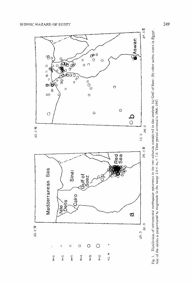
people were killed, 6500 people were injured and 8300 buildings were damaged or destroyed in the Cairo area only. Preliminary estimation of damages indicate losses of about US$300 million. Reports reveal that many historical constructions (i.e., mosques, pyramides and temples) suffered from the earthquake. The 1992 earthquake is not included here since our analysis is limited to data up to 1987. Generally speaking, earthquakes such as those in 1969, 1981, and 1992 can affect sensitive structures and buildings. To establish an idea about the limits of seismic risk in Egypt, seismic hazard analysis was carried out using the method of maxi- mum likelihood of Kijko and Sellevoll (1990). This method combines scattered data of large historical earthquakes with more consistent data of recent, instrumen- tally detected earthquakes. This is a suitable method for Egypt, where earthquake data from different time periods have different degree of homogeneity. In the present analysis, two sets of data covering the major seismic zones were treated separately. The two sets comprise (1) Gulf of Suez and (2) the other active zones in Egypt (Figure 1).
2. Comment on the Method
The applied procedure (Kijko and Sellevoll, 1990) is a maximum-likelihood me- thod for estimating the earthquake hazard parameters, such as maximum magni- tude, M . . . . annual activity rate, A, and b parameter of the Gutenberg-Richter relation. The method allows us to use a catalogue containing different parts: Macroseismic information of strong historical earthquakes as well as instrumental data of more recent events. The former part will hereafter be referred to as the extreme part and the latter as the complete part of the catalogue. The complete part in turn comprises several subparts with different magnitude thresholds of completeness. The method of Kijko and Sellevoll also permits gaps in the data sets, i.e., periods with no reported events. Two values, the upper and the lower magnitude bounds, are given for each event, and this interval is presumed to include the real value.
Actually, the maximum-likelihood procedure is applied when evaluating par- ameters A and b. The basic assumptions behind the probability calculations are the Poisson distribution of earthquakes with an activity rate A and the doubly truncated Gutenberg-Richter distribution of magnitude. Further information has to be utilized for evaluation of Mma×- Here, the evaluation is performed on the basis of earlier experimental results according to which the largest observed magnitude of the data set provides a sufficient evaluation of the largest expected magnitude. The theory is presented in detail in Kijko and Sellevoll (1990).
3. Earthquake Data
A search for earthquake data was made by using ISC, NEIS and other catalogues. Various publications, in particular the work of Maamoun et al. (1984), were
SEISMIC H A Z A R D OF E G Y P T
°
o 8 J c ~ o o 0
o o
0
uJ o
OC~
~o~ 0
0
0 0
o 0
z o
4 ¢rl
0 0
0
0
I " ~ ~ ~ I " I
,I ¢:
o
Od
0
O3 OJ
u.I o
z
('o 0Q
o o 0 0 0 "
7/ ~: ~: ~ ~
8
(D
O fq
O
ctl
249
Z"
m
0 ~
~%
,2d
E
~0
~ 8
Cz~

250 A. EL-SAYED ET AL.
considered as well. Comparison between the available data sets showed that the ISC bulletins are complete for earthquakes of magnitude >3.5, while the Maam- oun et al. (1984) catalogue contains also many smaller events not found in ISC bulletins. The data set we used was derived from the ISC and Maamoun et al.
(1984) catalogues. To homogenize magnitudes from the two catalogues we used a formula by Maamoun et al. (1984). Since earthquakes with small magnitude can be neglected in the context of the present study, our analysis was limited to earthquakes with magnitude I>3. Altogether, 956 such earthquakes are reported to have occurred in Egypt in the time period 1906-1987, many with relatively high magnitudes. The largest and most destructive events were already mentioned above.
A similar search was made in a number of publications concerning the historical earthquakes. These include Gutenberg and Richter (1954), Ambraseys (1975, 1983), Poirier and Taher (1980) and Maamoun et al. (1984). In total, 22 earth- quakes with intensity >~VII and probable magnitude ~>4.5 were found to occur during the time period 320-1906. Another 10 earthquakes had to be ignored because of insufficient information about the magnitude and epicentre location. However, the rest of the earthquakes are well described by Maamoun et al. (1984) who provide areas of maximum damages, probable upper and lower limits of magnitudes and intensities as well as other associated features.
4. Subareas
Due to large differences in seismicity level, the area under study was divided into two subareas, The geographic location of earthquake epicentres in the two sub- areas is shown in Figure 1.
The first subarea is the Gulf of Suez, which represents the most active zone in Egypt. Historically, this area was affected by many earthquakes in the magnitude range 4.0-6.2 (Ismail, 1960; Gergawi and Khashab, 1968; Maamoun et al . , 1984). Recently, Daggett et al. (1986) reported that on average some 25 earthquakes with magnitude 0.7-3.1 occur daily and swarms with some 200 earthquakes occur once per week in this area. The activity in the Gulf of Suez is related to a number of tectonic elements, like the Red Sea rift axis and the moving adjacent Arabian, Sinai and African plates (Courtillot et al. , 1987; Gaulier et al. , 1988; Martinez and Cocheran, 1988). Kulhfinek et al. (1992a, b) showed that the maximum activity is noticed where two or more tectonic elements interact with each other. In total, 688 earthquakes with magnitude >~3 are reported to have occurred in this subarea in the time period 1906-1987.
The second subarea includes the Egypt-Mediterranean coastal zone and all other local zones in Egypt (Figure 1). Historically, many earthquakes with magnitudes 4.5-6.5 have taken place in these areas (Maamoun et al . , 1984). Also recently, several strong earthquakes occurred there. For example, in 1978 and 1981 Gill E1-Kabir and Kalabsha (Aswan) were shaken by earthquakes with magnitudes 5.1

SEISMIC H A Z A R D OF EGYPT 251
and 5.6, respectively. EI-Shazly et al. (1979) and Issawi (1981) studied some of these local zones and concluded that they are structurally controlled by many faults of Miocene-Oligocene age. The distribution of earthquakes epicentres is concentrated along these faults (Kebeasy et al., 1981). More recent studies reveal that there is an on-going reactivation of some of these Miocene-Oligocene faults (E1-Sayed, 1989; Mousa, 1989). Altogether, 268 earthquakes with magnitude ~>3 were reported during the time period 1906-1987 in this subarea.
5. Subcatalogues
The compiled set of data used in the present calculation (all earthquakes with magnitude/>3) was divided into two main parts, the extreme part (historical data) and the complete part (instrumental data).
The time period before 1906 was considered to be the extreme part. Four earthquakes with magnitude ~>5.0 were reported from the Gulf of Suez subarea during the time period 1778-1905. Eighteen earthquakes with probable magnitude />4.5 were reported from the other active zones in Egypt in the time period 320- 1905. Most of these earthquakes occurred in the Egypt-Mediterranean coastal zone and two in the Aswan area (Maamoun et al., 1984). The assigned magnitude uncertainty for each historical event is 0.35 or 0.7 as given by Maamoun et al.
(1984) and as judged by the present authors from uncertainties of macroseismic parameters. The smaller value of uncertainty is ascribed to larger earthquakes with better known geological land features and macroseismic data and the larger value to smaller events with more uncertain data (Maamoun et al., 1984).
The first instrumental data are from 1906, which is here, therefore, chosen as the beginning of the complete part of the catalogue. The complete part was subdivided into two subcatalogues based on the frequency of seismic events (Figure 2). The first subcatalogue corresponds to the period prior to WWSSN operation, i.e., to the interval 1906-1961. In total, 36 earthquakes (magnitude />3) were reported from the Gulf of Suez and 87 earthquakes from the other active zones in Egypt during this time period. Frequency-magnitude diagrams (Figures 3a, 4a) provide reliable indications about the threshold magnitude. As follows from the figures, a magnitude about 5 seems to be a reasonable threshold-magnitude esti- mate for both subareas. An interval of 0.3 was considered as a realistic magnitude uncertainty for earthquakes of this part of the catalogue. This estimate is a compro- mise between the magnitude error of the historical data (0.7 or 0.35) and the magnitude error of the more recent data (0.25). Maamoun et al. (1984) gave the same value (0.3) for events in this time interval.
The second complete subcatalogue covers roughly the period of operation of the WWSSN, i.e., 1962-1987. As can be seen in Figure 2, the seismicity is at a higher level in the mid 1950s but decreases in the late 1950s. Since 1962, the rate of activity is continuously high. Two earthquake swarms were noticed in this time period, the Shadwan swarm in 1969 and Aswan swarm in 1981 (Figure 2). During

252
103
A. EL-SAYED ET AL.
~D
O
E
102
10 ~
10' 1900
a
1910 1920 1930 1940 1950 1960 1970 1980 1990
90
~D
O
"d
80
70
60
50
40
30
20
10
0 1900
b
,/k ^
1910 1920 1930 1940 1950 1960 1970
~ r
1980 1990
Time (years)
Fig. 2. Temporal annual variation of seismic activity, m~, ~> 3.0, based on instrumental data: (a) Gulf of Suez; (b) other active zones in Egypt.

SEISMIC HAZARD OF EGYPT
10 2
253
Z
+ + +
l 0 t
a
+ 4"
4- 4" 4- +
4- + +
+ +
4- +
+
• O I I I I
1 0 3 3.5 4 4.5 5
+
+
+
+
5.5
103
10:
iT'
101
I0 o
+ 4- 4- + i + +
4- +
+ +
+ +
+ +
+ 4-
+
+ 4-
+ + +
+ +
b ÷ +
+
i I I i I ~ . . . . .
3.5 4 4.5 5 5.5 6 6.5
Magnitude m b
Fig. 3. Frequency-magnitude distribution for the Gulf of Suez area and two different time periods: (a) 1906-1961; (b) 1962-1987. Arrows indicate thresholds of completeness.

254
102
A, EL-SAYED ET AL.
0
101
+ + + + 4-
a
+ + + + +
+ 4.
+ + +
+ ÷ + 4"
+
4" +
4"
+
+
+
+ + -I-
I I I l I
1003 3.5 4 4.5 5 5.5 6
10 3
O
+ + + + + + ! + + +
102
101
+ +
+ +
÷
+ +
+ +
+ + +
+ + +
+ +
+ +
+
+ +
+
, I , I I I i , i I I
1012 2.5 3 3.5 4 4.5 5 5.5 6
Magnitude m 13
Fig. 4. Frequency-magnitude distribution for other active zones in Egypt and two different time periods: (a) 1906-1961; (b) 1962-1987. Arrows indicate thresholds of completeness.

SEISMIC HAZARD OF EGYPT 255
Table I. Time period, threshold magnitude (TM), magnitude uncertainty (ME) and number of earthquakes (N) for various subcatalogues
Subcatalogue Time period Gulf of Suez area Other active zones in Egypt
TM ME N TM ME N
Extreme * - * * 4 - ** 18
Complete 1 1906-196l 5.0 0.30 36 5.0 0.30 87 Complete 2 1962-1987 3.5 0.25 652 3.0 0.25 181
* 1778-1905 for the Gulf of Suez; 320-1905 for the other active zones. ** 0.35 or 0.70 (see text).
Table II. Seismic hazard parameters
Parameter Gulf of Suez area Other active zones in Egypt
b 1.2--_0.1 1.0+0.1 A a 39.0 -+ 2.0 6.1 -+ 0.4 Mmax 6.5 ± 0.4 6.1 ± 0.3
a Threshold magnitude of 3.5 for the Gulf of Suez and 3.0 for the other active zones in Egypt.
this period, 652 earthquakes (magni tude/>3) were reported f rom the Gulf of Suez
and 181 f rom the other active zones. To examine the threshold magnitude in
the other active zones, the frequency-magnitude analysis was extended down to magnitudes ~>2. As a result, threshold estimates of 3.5 and 3.0 were obtained for
the Gulf of Suez and the other active zones in Egypt, respectively (Figures 3b, 4b). Maamoun et al. (1984) calculated the threshold magnitude based on all Egyptian ear thquake data to 5.0 and 3.6 for the time periods 1906-1961 and 1962- 1987, respectively, which is in good accordance with our values. A magnitude
uncertainty of 0.25 is taken from Maamoun et al. (1984). Table I summarizes the time periods, threshold magnitudes, magnitude uncer-
tainties and total number of ear thquakes obtained for various subcatalogues.
6 . R e s u l t s
Estimates of b, A and Mmax calculated for the Gulf of Suez and areas containing the other active zones in Egypt are given in Table II. The relative contribution of data provided by the various subcatalogues in the calculation of b and A are given in Table III . An independent test has been done by calculating the b-values for Egypt and the Gulf of Suez using the maximum likelihood method of Aki (1965) and Utsu (1966). Obtained average values of 1.2 (Gulf of Suez) and 1.0 (other
areas) are in excellent agreement with those given by the present method (Table II). EMsa and A1-Shanti (1989) and Rebor to et al. (1992) calculated b for different areas along the Red Sea. For the northern Red Sea area, the lowest values of 0.6 and 0.86 were obtained in the two investigations respectively, for the Gulf of Suez.

256 A. EL-SAYED ET AL.
Table III. Relative contribution (%) of various subcatalogues for computation of b and A
Subcatalogue Gulf of Suez area Other active zones in Egypt
b A b
Extreme 48 0.9 78 7.7 Complete 1 7 0.8 6 7.1 Complete 2 45 98.3 16 85.2
10 4
0
10 3
10 2
101
10 0
10 q
10-2
. ' " ° ' ° ' ~
I ~ I i I i 3.5 4.5 5 5.5 6 6.5
Magnitude m b
Fig. 5. Mean return periods for earthquakes in the Gulf of Suez (solid line) and the other active zones in Egypt (dashed line).
Mean return periods and probabilities of nonexceedance are summarized in Figures 5 and 6, respectively. The annual rate of occurrence and the return period for earthquakes with magnitude 6.0 were also calculated by El-Isa and AI-Shanti (1989) and Reborto et al. (1992) for the Gulf of Suez. Their values of the return period (53 and 70 years respectively) are significantly lower than ours, given in Figure 5. This discrepancy is most likely due to the rather small number of events which they have been using in the calculations.
As shown in Table II, the maximum expected magnitude in the Gulf of Suez is 6.5 -+ 0.4 for a time period equal to the length of the catalogue, i.e., 210 years.

SEISMIC H A Z A R D OF E G Y P T 257
0.5
4 5 6
Gulf of Suez area
0.5
*? r~ o
o
e , ,
Other active zones in Egypt
0 0 j 3 7 4 5 6
/ / J
,I . . . . r ' " , i ,
Magnitude mb Magnitude m b
Fig. 6. Probability of nonexceedance for the two subregions. Solid and dashed lines represent proba- bility of nonexceedance in one and 50 years, respectively.
For the other active zones in Egypt, the maximum expected magnitude is 6.1 + 0.3 for a time span of 1668 years.
7. D i scus s ion
Calculated b-values for different areas reflect the various tectonic situations. The b-value can serve as an indicator of stress concentration, crack density and degree of heterogeneity. As the crustal deformation increases, the b value decreases. For example, in Japan and Taiwan, small b values were observed in areas of high crustal deformation (Mogi, 1962; Welkner, 1967; Wang, 1988). Recent seismic and gravity studies (Bayoumi, 1983; Martinez and Cocheran, 1988; Gaulier et al . ,
1988) show that the Gulf of Suez is highly deformed and has rather heterogeneous crustal structure. Also, E1-Shazly et al. (1979) and Maamoun et al. (1980) showed that, except for some local parts, the whole Egyptian crust is highly deformed. This may explain the relatively low b value deduced for the Gulf of Suez and other active zones in Egypt when compared, e.g., with the area around the Nile Valley.

258 A. EL-SAYED ET AL.
Inspection of the Egyptian earthquake catalogue indicates that the calculated return period for large earthquakes is reasonable. For example, the return period for earthquakes of magnitude ~>5.0 is around 8 years in the Gulf of Suez and 21 years in the other active zones in Egypt (Figure 5). Earthquakes with these magnitudes and which also caused damage were reported in the Gulf of Suez in March 1952, March 1969, April 1972, and June 1983, and in the other active zones in Egypt in December 1956, November 1981 and October 1992.
It should be emphasized that many of the largest recent Egyptian earthquakes occurred in areas of critical or sensitive structures. For example, the earthquakes of 1969 and 1972 took place close to the largest oil field in Egypt, the event of 1981 occurred upstream close to the Aswan High Dam and the disastrous event of 1992 hit the densely populated area of Cairo. To protect the society and sensitive structures from earthquake risk and to implement further smooth economic devel- opment of the country, earthquake hazard parameters should be taken into ac- count in urban planning, large industrial constructions, building of energy re- sources, etc.
A main conclusion of the present study is that the seismic hazard is significantly higher in the Gulf of Suez area than in the other active zones in Egypt. These two areas are expected to be affected by major earthquakes (rob >t 5) on average once in eight and once in 21 years, respectively.
Acknowledgements
This work has been carried out at the Seismological Department, Uppsala Univer- sity, Sweden. The authors would like to thank M. E1-Gamili and I. Korrat, Geology Department, Mansoura University, Egypt, for critically reading the manuscript. Our thanks are due to A. Kijko and E. Skordas for providing the seismic hazard computer program and giving the necessary instructions.
References Aki, K.: 1965, Maximum likelihood estimation of b in the formula Log N = a - bM and its confidence
limits, Bull. Earthquake Res. 43,237-239. Ambraseys, N. N.: 1975, Studies of historical seismicity and tectonics, Geodynamic Today, Royal
Society of London. Ambraseys, N. N.: 1983, A note on historical seismicity, Bull. Seisrnol. Soc. Am. 73, 1917-1920. Bayoumi, A. I.: 1983, Tectonic origin of the Gulf of Suez Egypt as deduced from Gravity data,
Handbook, Geophysics Exploration at Sea, CRC Press, Boca Raton, pp. 417-431. Courtillot, V., Armijo, R., and Tapponnier, P.: 1987, The Sinai triple Junction revisited, Tectonophys-
ics 141, 181-190. Daggett, P. H., Morgan, P., Boulous, F. K., Hennin, S. F., E1-Sherif, A. A., El-Sayed, A. A., Basra,
N. Z., and Melek, Y. S.: 1986, Seismicity and active tectonics of the Egyptian Red Sea margin and northern Red Sea, Tectonophysics 125, 313-324.
El-Isa, Z.H. and AI Shanti, A.: 1989, Seismicity and tectonics of Red Sea and western Arabia, Geophys. J. 97, 449-457.
SEISMIC HAZARD OF EGYPT 259
EI-Sayed, A.: 1989, Geophysical studies on Sinai Peninsula A.R.E. MSc thesis, Mansoura University Egypt.
El-Shazly, E. M., Abdel Hady, A. M., El-Ghawaby, A. M., E1 Kassas, I. A., Khawasik, S. M., EI- Rakaiby, M, M., and Aassy, I. E.: 1979, Structural lineament map of Egypt based on landsat satellite imagery interpretation field and laboratory investigation, Acad. Sci. Res. TechnoL, Cairo.
Gaulier, J. M., Le Pichon, X., Lybris, N., Avedik, F., Geli, L., Moretti, I., Deschamps, A., and Hafez, S.: 1988, Seismic study of the crust of the northern Red Sea and Gulf of Suez, Teetonophysics 153, 55-88.
Gergawi, A. and Khashab, A.: 1968, Seismicity of U.A.R., Helwan Observatory Bull. No. 76. Gutenberg, B. and Richter, C. F.: 1954, Seismicity of the Earth, Princeton University Press New
Jersey. Ismail, A.: 1960, Near and local earthquake of Helwan (1903-1950), Helwan Observatory, Bull. No.
49. Issawi, B.: 1981, Geology of South Western Desert of Egypt. Ann. Geol. Survey Egypt l l , 57-66. Kebeasy, R., Maamoun, M., Albert, R., and Megahed, A. ; 1981, Earthquakes activity and earthquake
risk around Alex, Bull. LIEGE 19, 93-113. Kijko, A. and Sellevoll, M. A.: 1990, Estimation of the earthquake hazard parameters from incomplete
data files, Natural Hazards 3, 1-13. KulMnek, O., Korrat, I., and E1-Sayed, A.: 1992a, Connection of the seismicity in the Red Sea and
Egypt, published abstract, tenth annual meeting of Egyptian Geophysical Society, March 1-3, 1992. Kulh~nek, O., Korrat, I., and E1-Sayed, A.: 1992b, Recent seismic activity and general tectonic
situation in the Red Sea, published abstract, tenth symposium on Quaternary and development in Egypt, E1-Mansoura University Geology Department, 18 April 1992.
Maamoun, M. and Ibrahim, E. M.: 1978, Tectonic activity in Egypt as indicated by earthquakes, Bull. HIAG, No. 170.
Maamoun, M., Allam, A., Megahed, A., and Abu E1-Atta, A.: 1980, Neotectonic and seismic regionalization of Egypt, Bull l lSEE 18, 27-39.
Maamoun, M., Megahed, A., and Allam, A.: 1984, Seismicity of Egypt, H1AG. Bull. B 4. Martinez, F. and Cocheran, J. R.: 1988, Structure and tectonic of the northern Red Sea: Catching a
continental margin between rifting and drifting, Tectonophysics 150, 1-32. Mogi, K.: 1962, Magnitude frequency relation for elastic shocks accompanying fractures of various
materials and some related problems in earthquakes, Bull Earthquake Res. 40, 831-853. Mousa, H.: 1989, Earthquakes activities in Egypt and adjacent regions and its relation to geotectonic
features in A,R.E. Egypt, MSc thesis, Mansoura University, Egypt. Poirier, J. P. and Taher, M.: 1980, Historical Seismicity in the near and Middle East north Africa and
Spain from Arabic documents (VIIth-XVIIth Century), Bull Seismol. Soc. Am. 70, 185-201. Reborto, P., Paolo, L., and Dimitris, D.: 1992, Seismotectonic regionatization of the Red Sea area
and its application to seismic risk analysis, Natural Hazards 5, 233-247. Utsu, T.: 1966, Statistical significance test of the difference in b value between two earthquake groups,
J. Phys. Earth 14, 37-40. Wang, J. H: 1988, b value of shallow earthquake in Taiwan, Bull. Seismol. Soc. Am. 78, 1243-1254. Welkner, P.: 1967, On the space distribution of some parameters in Japan, Part I, Bull. Intl. Inst.
Seismol. Earthquake Eng. 4, 1-18.