sedimentology of lower pliocene to upper pleistocene
TRANSCRIPT

http://journals.cambridge.org Downloaded: 18 Mar 2014 IP address: 130.68.124.68
Antarctic Science 26(2), 183–192 (2014) & Antarctic Science Ltd 2013 doi:10.1017/S0954102013000527
Sedimentology of lower Pliocene to Upper Pleistocene diamictonsfrom IODP Site U1358, Wilkes Land margin, and implications
for East Antarctic Ice Sheet dynamicsNADINE OREJOLA1, SANDRA PASSCHIER1* and IODP EXPEDITION 318 SCIENTISTS-
1Department of Earth and Environmental Studies, Montclair State University, 1 Normal Ave, Montclair, NJ 07043, USA
*Corresponding author: [email protected]
yFor a full list of authors see http://publications.iodp.org/proceedings/318/staff.htm
Abstract: During the early Pliocene a dynamic marine-based ice sheet retreated from the Wilkes Land
margin with periodic ice advances beyond Last Glacial Maximum position. A change in sand provenance is
indicative of a more stable Mertz Glacier system during the Late Pleistocene. East Antarctic Ice Sheet
(EAIS) dynamics were evaluated through the analysis of marine diamictons from Integrated Ocean Drilling
Program (IODP) site U1358 on the Adelie Land continental shelf. The warmer than present conditions of
the early Pliocene coupled with the site’s proximity to the landward sloping Wilkes Subglacial Basin
provided the rationale for the investigations at this site. Based on visual core descriptions, particle size
distributions, and major and trace element ratios, we interpret the origin of lower Pliocene strata by
intermittent glaciomarine sedimentation with open-marine conditions and extensive glacial advances to the
outer shelf. Heavy mineral analyses show that sand-sized detritus in the lower Pliocene strata was sourced
from local intermediate to high-grade metamorphic rocks near Mertz Glacier. In contrast, Pleistocene
diamictons exhibit a larger contribution from a prehnite-pumpellyite greenschist facies suggesting supply
via iceberg rafting from northern Victoria Land. From this sedimentological evidence, we postulate a shift
from a dynamic EAIS margin in the early Pliocene to possible stabilization in the Pleistocene.
Received 23 January 2013, accepted 12 June 2013, first published online 13 August 2013
Key words: continental shelf, geochemistry, heavy minerals, particle size, provenance
Introduction
Integrated Ocean Drilling Program (IODP) ‘‘Wilkes Land’’
Expedition 318 collected seven marine sediment cores from
sites off the Terre Adelie and George V Coast during the
summer of 2010 (Fig. 1). The objective was to reconstruct
East Antarctic Ice Sheet (EAIS) behaviour during climate
fluctuations from the Eocene epoch to present-day as an
analogue for ice sheet behaviour in response to future
global climate changes (Escutia et al. 2011).
Located offshore from the Wilkes Subglacial Basin, the
margin was deemed an ideal location for investigations
of ice sheet dynamics because the ice sheet is grounded below
sea level and therefore possibly sensitive to ocean and surface
warming. On the continental shelf west of Mertz Bank, two
sediment cores from hole U1358 were retrieved using the
rotary core barrel system (RCB). Core U1358B was the more
successful of the two that retrieved marine and glacial
sediment down to 35.6 m below sea floor (b.s.f.) (Expedition
318 Scientists 2011). A multichannel seismic reflection profile
revealed a significant unconformity (WL-U8) at c. 165 m b.s.f.
(Fig. 1), believed to indicate a change in glacial thermal
regime in the mid- to late Miocene (Escutia et al. 2005),
however, WL-U8 was not reached during drilling (Expedition
318 Scientists 2011).
Site U1358 is located in the Mertz trough, between the
Adelie and the Mertz banks, on the continental shelf off the
Adelie Coast at 499 m below sea level (m b.s.l.) (Fig. 1).
The sea floor in the Mertz Trough displays a megaflute
morphology indicative of ice advance by the Mertz Glacier
to an outer shelf position just landward of site U1358 most
likely during the Last Glacial Maximum (LGM) (Domack
1982, Beaman & Harris 2003). Today and in the past, shelf
currents and iceberg scouring in water shallower than
500 m have modified the diamictons outcropping at the sea
floor on the George V shelf (Beaman & Harris 2003).
Seismic profiles show that sometime between the mid–late
Miocene and the LGM the ice sheet oscillated with glacial
advances to the shelf break and extended beyond the LGM
position (Escutia et al. 2005).
IODP site U1358B provides a unique opportunity to
assess a portion of this older record, specifically, to
reconstruct early Pliocene–Late Pleistocene ice sheet
dynamics at an EAIS-proximal site. The objective of this
paper is to: i) observe and describe variations in diamicton
depositional processes using particle size distribution
analysis, ii) investigate diamicton provenance and source
terrains by conducting heavy mineral analyses, and
iii) summarize changes in chemical weathering, sediment
recycling, and biogenic productivity from the early
183

http://journals.cambridge.org Downloaded: 18 Mar 2014 IP address: 130.68.124.68
Pliocene–Late Pleistocene. The compiled data from the
three experiments were used to address the fundamental
questions of ice sheet stability and drainage patterns on the
Wilkes Land margin during this critical time of warming in
the Southern Ocean (Whitehead & Bohaty 2003, Escutia
et al. 2009).
Materials and methods
Cores from hole U1358B were described on-board ship
through visual description of the cut face of the archive half
(Expedition 318 Scientists 2011; Fig. S1, which will be
found at http://dx.doi.org/10.1017/S0954102013000527).
Core 1R consists of unconsolidated light brownish grey
massive clast-rich muddy diamicton with trace abundances
of diatoms. Cores 2R–4R consist of consolidated greenish
grey to grey massive to crudely stratified clast-rich sandy
and muddy diamicton (Fig. 2). A distinct colour change
from greenish grey to grey was observed between cores
2R and 3R. Below 20.45 m b.s.f. the diamicton is sparsely
stratified with planar horizontal to inclined beds and
laminations. The diamictons contain between 5% and 7.5%
clasts up to 24 cm in diameter (Fig. 2). Clast lithologies
include facetted basalt and fine-grained metasediments, and
polished granitic gneiss and quartzite, all with subangular
to subrounded shape. Hole U1358B yielded 23 diamicton
samples that were processed for laboratory analyses at
Montclair State University (Montclair, NJ, USA).
Particle size analysis
A Malvern Mastersizer 2000 laser particle sizer was used
to analyse grain size distributions and to determine the
dominant diamicton sedimentation process on the Wilkes
Fig. 1. Four of the seven Integrated Ocean Drilling Program (IODP) Expedition 318 site locations on the George V continental shelf
and rise. Site U1358 on the continental shelf is the focus of this paper (modified from Beaman et al. 2011). Inset A: simplified bed
topography (after Fretwell et al. 2013), WSB 5 Wilkes Subglacial Basin. The study area is indicated by a red square. Inset B: line
drawing of Oligocene and younger sequences above unconformity WL-U3 in seismic line IFP 107 (cf. Escutia et al. 2005).
184 NADINE OREJOLA et al.

http://journals.cambridge.org Downloaded: 18 Mar 2014 IP address: 130.68.124.68
Land margin continental shelf. Based on the amount of
available sample material, 21 of the 23 samples from hole
U1358B were prepared for sediment particle size analysis
(Konert & Vandenberghe 1997, Sperazza et al. 2004).
Samples were prepared four at a time using 30% hydrogen
peroxide to disaggregate the sediment and then boiled
with deionized (DI) water and 10% HCl on a hot plate to
remove carbonate and organic material. The disaggregated
samples were centrifuged at 1500 rotations per minute
(rpm) for 30 min and the supernatant liquid was removed
from the centrifuge tubes. Sodium pyrophosphate was
added as a dispersant and the samples were heated for
complete dissolution of the dispersant. Once the samples
were cooled, they were analysed on the laser particle
sizer using a laser obscuration of 20–40%. Particle size
distribution histograms were generated and raw data was
utilized in the calculation of fractal dimensions with the
purpose of determining changes in down core diamicton
formation processes (Hooke & Iverson 1995, Licht et al.
1999, Benn & Gemmell 2002, Principato et al. 2005).
Geochemical analysis
Major and trace element geochemical analyses of the
matrix of 20 samples were carried out using a Jobin-Yvon
ULTIMA C inductively coupled plasma optical emission
spectrometer (ICP-OES; HORIBA Jobin Yvon Inc, Edison,
NJ, USA). The fine fraction (, 63 mm) was isolated from
bulk samples through standard wet-sieving with a rubber
spatula and deionized water to break up the matrix. The fine
fraction (, 63 mm) and coarse fraction (63–250 mm) were
placed in ceramic bowls, dried at 758C overnight, and
transferred into vials. Sample preparation for ICP-OES
analysis followed Murray et al. (2000) and was carried out
on the fine fraction (, 63 mm). Approximately 0.1 g of
sample and 0.4 g of Lithium Metaborate flux (LiBO2) were
mixed together and carefully transferred to graphite
crucibles, which were placed in a furnace at 10508C for
30–40 min. When removed from the furnace, samples were
transferred into Teflon beakers with magnetic stir bars and
50 ml of 7% nitric acid and placed on a magnetic stir plate
Fig. 2. Core photographs of representative core sections. Arrows indicate sample locations. Depth in meters below sea floor (m b.s.f.)
for the top of the core intervals are shown. Core numbers and offset in cm can be found at the bottom of each photograph. Of note
are the large rock clast in interval 2R-1, 33–83 cm, the massive and homogenous nature of the diamictons in interval 3R-1, 5–55 cm,
the inclined stratification in 3R-3, 50–100 cm, and the horizontal stratification in interval 4R-1, 52–102 cm.
PLIO-PLEISTOCENE SHELF DIAMICTS IODP SITE U1358 185

http://journals.cambridge.org Downloaded: 18 Mar 2014 IP address: 130.68.124.68
until the sample was dissolved. Once dissolved, it was
poured over a filter into a sample bottle and placed in
a refrigerator. Immediately before measurement on the
ICP-OES, the samples, along with 12 USGS standards for
calibration, were diluted using 2% nitric acid.
The ICP-OES geochemical data (Tables S1 & S2, which
will be found at http://dx.doi.org/10.1017/S0954102013
000527) is represented as element ratios (Fig. 3b). To infer
the degree of chemical weathering, the chemical index of
alteration (CIA) was calculated with a correction for the
presence of biogenic and terrigenous carbonate (Nesbitt &
Young 1982). To assess sediment recycling we used Zr/Sc
ratios, which are high for mature marine sediments on
passive continental margins (McLennan et al. 1993). TiO2/
Al2O3 ratios are primarily controlled by rock provenance
and vary widely in soils developed on mafic vs felsic
igneous source rocks (Nesbitt & Young 1996). We calculated
Ba-excess values to assess marine palaeoproductivity
(Schenau et al. 2001). For the calculation of the Ba-excess
values the lithogenic Ba component was derived from the
average whole-rock composition of clasts collected in
dredges near the Mertz Glacier tongue (Goodge & Fanning
2010). The clasts are probably derived from Mertz Glacier
and are assumed to be a representative sampling of the local
bedrock, which is largely inaccessible due to the presence
of the ice.
Heavy mineral analysis
A Hitachi scanning electron microscope (SEM) S-3400N
with Bruker electron dispersive spectroscopy (EDS) system
was used to determine the mineralogical variety in the
sand fraction of 18 samples that were chosen based on the
amount of available coarse fraction. Heavy minerals
were separated by pouring the entire fine sand fraction
(63–250 mm sieve residue) into 50 ml centrifuge tubes filled
with heavy liquid (sodium polytungstate; 2.89 g c m-3). The
centrifuge tubes were rotated for 15 min at 3000 rpm and
when completed, dry ice was used to freeze the tips of the
tubes to isolate the heavy minerals while pouring the lighter
minerals through a filter. The remaining heavy mineral
grains were filtered out, cleaned with deionized water,
Fig. 3. Downcore distributions of a. lithologies, b. major and trace element geochemistry, c. particle size distributions, and d. heavy
mineral petrology for Integrated Ocean Drilling Program (IODP) hole U1358B. In d. numbers in brackets refer to mineral
assemblages and source terrains reported in Table S3, which will be found at http://dx.doi.org/10.1017/S0954102013000527.
186 NADINE OREJOLA et al.
http://journals.cambridge.org Downloaded: 18 Mar 2014 IP address: 130.68.124.68
dried, weighed, and placed in 18 separate wells drilled in
two lucite discs (nine wells per disc) using tape for the
grains to adhere and prevent extraneous material from
entering the specified wells. The wells were then filled with
a 5:1 ratio of epoxicure resin and hardener. The analytical
sides of the sample discs were diamond polished, then
carbon coated and analysed at 15.0 keV with a c. 10 mm
working distance. Thirty-five grains per sample were
randomly selected for standardless EDS analysis. Electron
dispersion spectra were compared to characteristic mineral
spectra published by Reed (2005). Optical microscope
analysis assisted in the identification of garnet and gedrite
grains (Deer et al. 1992). Major elemental oxide weight
percentages (wt%) with an accuracy of 10% for oxides with
. 2 wt% abundances were determined using Esprit 1.9
software (Bruker). Compositions of pyroxenes and
amphiboles were recalculated back to cation proportions
using mineral formulae recalculation spread sheets from
http://serc.carleton.edu/ and plotted on quadrilateral diagrams.
Results
Particle size distributions
Particle size distributions are variable and both bi-modal
and uni-modal for cores 4R, 2R, and 1R, whereas the
distributions for core 3R are more uniform and uni-modal
(Fig. 3c). Fractal distribution values for all samples
were between 3.0 and 3.5, with r2 between 0.97 and 0.99
(Fig. S2, which will be found at http://dx.doi.org/10.1017/
S0954102013000527). Despite this dominant trend, two
samples from core 4R at 27.4 m b.s.f. and 27.28 m b.s.f.
within stratified diamictons interbedded with mudstones
displayed distinct coarse sand enrichments expressed as
humps in both the fractal plots and the grain-size histograms.
Geochemical analysis
Al2O3/TiO2 ratios vary between 20.43 and 21.96 and
support a uniform intermediate to felsic provenance for the
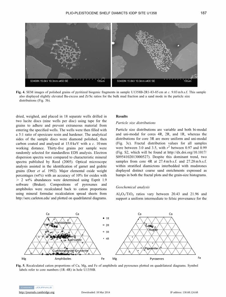
Fig. 4. SEM images of polished grains of pyritized biogenic fragments in sample U1358B-2R1-83-85 cm at c. 9.03 m b.s.f. This sample
also displayed slightly elevated Ba-excess and Zr/Sc ratios for the bulk mud fraction and a sand mode in the particle size
distributions (Fig. 3b).
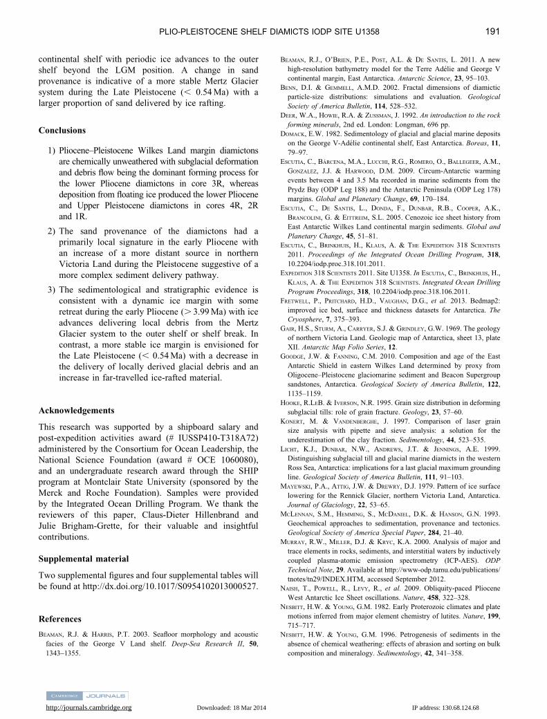
Fig. 5. Recalculated cation proportions of Ca, Mg, and Fe of amphibole and pyroxenes plotted on quadrilateral diagrams. Symbol
labels refer to core numbers (1R–4R) in hole U1358B.
PLIO-PLEISTOCENE SHELF DIAMICTS IODP SITE U1358 187

http://journals.cambridge.org Downloaded: 18 Mar 2014 IP address: 130.68.124.68
fine sediment fraction. Carbonate percentages were
measured shipboard on sediment samples in cores 1R, 3R
and 4R and yielded 2.8, 2.6 and 3.4 wt%. The CIA ranged
between 56 and 62 with one outlier sample in the core
catcher at the base of hole U1358B yielding a CIA of 52
associated with exceptionally high CaO concentration
(3.84 wt%). An outlier in Zr/Sc values was observed for
one sample in core 2R at 9.03 m b.s.f., which also had an
elevated Ba-excess ratio and a slightly elevated CIA of
62. Ba-excess values were the highest, however, in two
samples in core 4R (Fig. 3b).
Heavy mineral analysis
Single mineral grains and minerals of rock fragments were
assigned to consistent petrological assemblages that had been
identified down-core. Pie diagrams were generated to provide
a detailed representation of down-core variations in the
relative abundance of rock types and protoliths in U1358B
(Fig. 3d). Based on their co-occurrence in rock fragments,
nine distinct petrological assemblages are distinguished,
ranging from various grades of metamorphism with mafic/
intermediate and mafic protoliths as well as a mafic
dyke signature and a metamorphosed carbonate signature
(Table S3, which will be found at http://dx.doi.org/10.1017/
S0954102013000527). Other minerals not classified include
monazite and pyritized biogenic clasts (Fig. 4). The
quadrilateral diagrams reveal uniform down-core distribution
of amphiboles such as kaersutite, actinolite, hornblende, and
cummingtonite/grunerite and a few Ca-rich and Fe-rich
pyroxenes (Fig. 5).
Discussion
Depositional model
The grain-size distributions (Fig. 3c) and fractal dimensions
(Fig. S2, which will be found at http://dx.doi.org/10.1017/
S0954102013000527) of all 21 diamicton samples are
characteristic of a source region dominated by glacial
processes with an increase in the production of finer
material through grain slippage and abrasion, and/or
subglacial reworking of pre-existing (glacio) marine
sediments (Hooke & Iverson 1995, Benn & Gemmel
2002). The glacigenic origin for the diamictons recovered
in hole U1358B is confirmed by the bulk major element
analysis, which shows relatively low CIAs (56–62) indicative
of parent rocks that are chemically unweathered (Nesbitt &
Young 1982).
Preliminary shipboard investigations concluded that the
diamictons in the upper , 9 m b.s.f. (core 1R and section
2R-1) and those, which are crudely stratified and interbedded
with muds (below 20.45 m b.s.f.), were deposited from
floating ice (Licht et al. 1999). The stratification in sections
3R-3 and 4R-1 (Fig. 2) did not show evidence of boudinage
or other characteristics typical of glaciotectonic laminations
and were hence attributed to current activity. In agreement
with this, the diamictons in cores 1R, and the upper
portions of cores 2R and 4R show some enrichment
of sand and some sorting (Fig. 3c). The coincidence of
(non-glaciotectonic) planar laminations, mud interbeds, and
unconsolidated diamictons in these intervals suggest that the
primary sand modes are depositional or from winnowing, and
not a reworked signature derived from the source sediment.
Stratification and heterogeneous particle size distributions
with sand enrichments characterize glaciomarine diamicts
elsewhere on high latitude continental shelves (Licht et al.
1999, Principato et al. 2005) and current activity and iceberg
scouring are processes that have affected diamictons
outcropping at the sea floor in this area during the current
interglacial (Beaman & Harris 2003). In support of our
interpretation, the glaciomarine diamictons in section 2R-1
and 4R-1 display elevated Ba-excess values (Fig. 2b)
indicative of increased primary productivity (Schenau et al.
2001). The inclined bedding of the stratified diamicton in
section 3R-3 (Fig. 2) may signal iceberg scouring or a
transition to more ice-proximal conditions, as discussed below.
The massive diamictons between , 9 m b.s.f. and
20.45 m b.s.f. (bottom of core 2R and most of core 3R)
were initially interpreted as subglacial deposits with
possible remobilization by debris flows (Expedition 318
Scientists 2011). The uniform particle size distributions for
the deposits in section 2R-CC and core 3R confirm the
shipboard interpretations of subglacial deformation and
debris flow as the dominant diamicton forming process
(Licht et al. 1999, Passchier et al. 2003, Principato et al.
2005). Contemporaneous, sparse, diatom assemblages
reworked into the tills in core 3R, however, are indicative
of open-marine conditions (Expedition 318 Scientists
2011). Whereas the massive diamictons demonstrate that
ice advanced to the outer shelf or shelf break during
glacials of some part of the early Pliocene, the sparse
diatoms reworked into these diamictons may represent
retreat and open marine conditions during interglacials.
Sediment provenance
In shelf drill-cores, sand provenance studies can reveal
valuable information on major changes in the loci of glacial
erosion. From protolith/rock type pie diagrams (Fig. 3d),
we observe a shift in provenance from a contribution
from metapelitic rocks of the staurolite-sillimanite facies,
and high mafic granulite-amphibolite rocks in samples
from cores 4R and 3R, whereas samples from cores
2R and1R show an increase in the contribution from mafic
greenschist rocks of prehnite-pumpellyite facies. A mafic
igneous component remains constant throughout all sample
intervals. The amphiboles (kaersutite, actinolite, hornblende,
and cummingtonite/grunerite) point to a large contribution
from high/intermediate grade metamorphic rocks (Fig. 5).
188 NADINE OREJOLA et al.

http://journals.cambridge.org Downloaded: 18 Mar 2014 IP address: 130.68.124.68
The presence of cummingtonite and grunerite suggests that
the amphiboles carry a Wilkes Land basement signature
(Oliver & Fanning 2002, Goodge & Fanning 2010).
Pyroxenes, possibly derived from basement granodiorites
and/or the Ferrar Group, were identified throughout the
core but comprise a negligible overall contribution to the
heavy mineral assemblages in the fine sand fraction.
Specific U1358 mineral assemblages (Table S3, which will
be found at http://dx.doi.org/10.1017/S0954102013000527)
are indicative of the Archean metapelites and metagranitoids
found in the region bounded by the Port Martin and Mertz
Shear Zones (Oliver & Fanning 2002, Goodge & Fanning
2010). This cratonic terrane (Fig. 6) also contains mafic dyke
intrusions, mafic granulite/amphibolite metamorphosed rocks,
and marbles. Mineral assemblages, however, also identify a
low-grade metamorphic rock (prehnite-pumpellyite facies),
which resembles rock types found in outcrop far to the east in
the Bowers Terrane of northern Victoria Land and Oates
Fig. 6. a. Geological sketch map of East Antarctica with location of Integrated Ocean Drilling Program (IODP) site U1358 on the
George V continental shelf overlain on bed topography and palaeobathymetry. Geology based on Gair et al. (1969), Wodzicki &
Robert (1986), Oliver & Fanning (2002), and Goodge & Fanning (2010). NVL 5 northern Victoria Land, BT 5 Bowers Terrane,
WT 5 Wilson Terrane, CG 5 Cape Gray, MSZ 5 Mertz Shear Zone, PMSZ 5 Port Martin Shear Zone. Bed topography and
palaeobathymetry was plotted using GeoMap App (http://www.geomapapp.org) based on a data compilation of Ryan et al. (2009).
Green areas are bed topography above sea level, the continental shelf is tan to pink, the continental slope orange, the continental
rise is yellow, and the abyssal plain is blue. Iceberg tracks are based on satellite observations of Stuart & Long (2011). b. Scenario
for sediment delivery during glacial minima during the early Pliocene with more icebergs melting near their source due to warm
ocean temperatures. c. Scenario for sediment delivery during glacial maxima of the early Pliocene with ice extending to the shelf
break supplying sand with local provenance.
PLIO-PLEISTOCENE SHELF DIAMICTS IODP SITE U1358 189

http://journals.cambridge.org Downloaded: 18 Mar 2014 IP address: 130.68.124.68
Coast (Wodzicki & Robert 1986). Wet-based ice discharging
into Rennick Glacier covered this area until the late Miocene,
followed by exposure and soil production (Mayewski et al.
1979, Van de Wateren et al. 1999). A more recent ice
re-advance across this soil mantle led to the Rennick
Glacier grounding line extending c. 43 km northward,
followed by another, still ongoing, thinning and retreat
(Mayewski et al. 1979, Pritchard et al. 2009). Whereas
material from this source area is a subordinate component in
samples of cores 3R and 4R, its relative abundance is
increased in the samples of core 2R. Hence, we postulate a
change in source rock for the fine sand fraction within core 2R
with the loci of sediment delivery through glacial erosion
migrating eastward.
Palaeoclimatological implications
Diatom assemblages provide tentative age control for
hole U1358B (Expedition 318 Scientists 2011; Table S4,
which will be found at http://dx.doi.org/10.1017/S0954
102013000527). Based on the presence of Thalassiosira
antarctica Comber, core 1R, the upper 0.42 m b.s.f., is
assigned to the latest Pleistocene–Holocene (, 0.61 Ma),
with the absence of Actinocyclus ingens Ratray with last
occurrence (LO) at 0.54 Ma possibly constraining this
interval to within the last , 540 ky. A condensed interval
or a hiatus was inferred in core 2R at , 9 m b.s.f. Based on
the presence of Thalassiosira inura Gersonde (2.54–4.74 Ma)
and Thalassiosira torokina Brady (2.24–7.23 Ma), and the
absence of Thalassiosira lentiginosa (Janisch) Fryxell with
first occurrence (FO) at 3.99 Ma and Fragilariopsis curta
(van Heurck) Hustedt (FO at 3.56 Ma), the strata recovered in
the interval below the hiatus ( , 9 m b.s.f in section 2R-1) are
tentatively assigned an early Pliocene age.
The interval of no deposition or hiatus at , 9 m b.s.f.
(. 3.99 Ma to , 0.61/0.54 Ma) in U1358B overlaps with
a widespread erosion surface (pp-12) with tentative age of
3.9–3.6 Ma on the Prydz Bay continental shelf (O’Brien
et al. 2007) and a hiatus (. 4.2 Ma to , 3.4 Ma) within
a diatomite in the AND-1B core marking an erosion or
non-deposition event during full deglaciation of the Ross
Sea (Naish et al. 2009). The age control for the drill-holes
mentioned here, however, is not sufficient to evaluate
whether the erosion surfaces are coeval and the erosion
surfaces are not directly correlated in seismic data.
Interestingly, we observe a significant change in provenance
across the condensed interval or hiatus. Moreover, the
sediment matrix of the diamicton sampled at 9.03 m b.s.f. in
U1358B, which coincides with the hiatus, has an anomalous
major and trace element composition and a bimodal grain-size
distribution with a primary fine-sand mode consistent with
sediment sorting and winnowing. SEM analysis revealed the
presence of abundant biogenic pyritized sediment clasts
suggestive of local scouring and winnowing of a substrate of
biogenic sediments (Fig. 5).
Two different scenarios, or a combination of the two,
explain the observed changes in diamicton sedimentology
and sand provenance. First, variation in sand provenance
may reflect a change in ice-flow direction, with sediment
delivery directly by ice from more easterly sources during
the Pleistocene compared to the Pliocene. Second, the data
may reflect changes in sand delivery via iceberg rafting
during interglacial conditions, with this sand fraction then
being reworked into the diamicton upon glacial advance of
the Mertz Glacier system.
Today, most icebergs follow the counter-clockwise path
of the Antarctic coastal current (Stuart & Long 2011). For
the lower Pliocene glaciomarine strata (core 4R), the local
signature of the sand provenance suggests low iceberg
supply or survival rates from eastern sources, consistent
with a somewhat retreated ice margin (Fig. 6b) and higher
early Pliocene sea surface temperatures in the Southern
Ocean (Whitehead & Bohaty 2003, Escutia et al. 2009).
Diatom assemblages suggest a periodic high-nutrient,
open-water environmental setting, similar to that of the
modern-day Southern Ocean north of the winter sea ice
extent (Expedition 318 Scientists 2011). In contrast, the
local provenance of the ice-contact diamictons in core 3R
is indicative of shelf-wide ice advances by the Mertz
Glacier during the early Pliocene (Fig. 6c). Together, the
sedimentological, diatom, and geochemical evidence
suggests that the ice sheet may have lifted off the bed
and stayed in a more stable retreated position during some
portion of the early Pliocene (core 4R) with advances to
shelf break at a later time in the early Pliocene (core 3R).
For the Pleistocene (cores 2R-1R), the increase in
subglacial transport of sand from as far away as the
Bowers Terrane would require unrealistically long glacial
flow lines parallel to the coast and originating from
Rennick Glacier (Fig. 6a). It is also noteworthy that the
Al2O3/TiO2 ratios for the matrix of the diamictons remain
constant throughout U1358 indicating little change in the
provenance for the mud fraction (Fig. 3b). Given the distant
location, a transport path for the sand fraction via iceberg
rafting during interglacials seems more plausible. The
increase in far-travelled material can be explained by the
Late Pliocene decrease in sea surface temperatures in
the Southern Ocean and an increase in iceberg survival
rates (Whitehead & Bohaty 2003, Escutia et al. 2009).
A Pleistocene configuration (cores 2R and 1R) with sand
transport from the east is roughly in agreement with the
previously predicted path of the last ice advance across the
continental shelf in this area (Domack 1982). However,
based on a further increase in far-travelled sand-sized
detritus originating from the Bowers Terrane, we also infer
interglacial ice-rafting as a probable sediment transport
mechanism for a portion of the sand fraction in the Late
Pleistocene sediments.
In summary, during the early Pliocene a dynamic
marine-based ice sheet retreated from the Wilkes Land
190 NADINE OREJOLA et al.
http://journals.cambridge.org Downloaded: 18 Mar 2014 IP address: 130.68.124.68
continental shelf with periodic ice advances to the outer
shelf beyond the LGM position. A change in sand
provenance is indicative of a more stable Mertz Glacier
system during the Late Pleistocene (, 0.54 Ma) with a
larger proportion of sand delivered by ice rafting.
Conclusions
1) Pliocene–Pleistocene Wilkes Land margin diamictons
are chemically unweathered with subglacial deformation
and debris flow being the dominant forming process for
the lower Pliocene diamictons in core 3R, whereas
deposition from floating ice produced the lower Pliocene
and Upper Pleistocene diamictons in cores 4R, 2R
and 1R.
2) The sand provenance of the diamictons had a
primarily local signature in the early Pliocene with
an increase of a more distant source in northern
Victoria Land during the Pleistocene suggestive of a
more complex sediment delivery pathway.
3) The sedimentological and stratigraphic evidence is
consistent with a dynamic ice margin with some
retreat during the early Pliocene (. 3.99 Ma) with ice
advances delivering local debris from the Mertz
Glacier system to the outer shelf or shelf break. In
contrast, a more stable ice margin is envisioned for
the Late Pleistocene (, 0.54 Ma) with a decrease in
the delivery of locally derived glacial debris and an
increase in far-travelled ice-rafted material.
Acknowledgements
This research was supported by a shipboard salary and
post-expedition activities award (# IUSSP410-T318A72)
administered by the Consortium for Ocean Leadership, the
National Science Foundation (award # OCE 1060080),
and an undergraduate research award through the SHIP
program at Montclair State University (sponsored by the
Merck and Roche Foundation). Samples were provided
by the Integrated Ocean Drilling Program. We thank the
reviewers of this paper, Claus-Dieter Hillenbrand and
Julie Brigham-Grette, for their valuable and insightful
contributions.
Supplemental material
Two supplemental figures and four supplemental tables will
be found at http://dx.doi.org/10.1017/S0954102013000527.
References
BEAMAN, R.J. & HARRIS, P.T. 2003. Seafloor morphology and acoustic
facies of the George V Land shelf. Deep-Sea Research II, 50,
1343–1355.
BEAMAN, R.J., O’BRIEN, P.E., POST, A.L. & DE SANTIS, L. 2011. A new
high-resolution bathymetry model for the Terre Adelie and George V
continental margin, East Antarctica. Antarctic Science, 23, 95–103.
BENN, D.I. & GEMMELL, A.M.D. 2002. Fractal dimensions of diamictic
particle-size distributions: simulations and evaluation. Geological
Society of America Bulletin, 114, 528–532.
DEER, W.A., HOWIE, R.A. & ZUSSMAN, J. 1992. An introduction to the rock
forming minerals, 2nd ed. London: Longman, 696 pp.
DOMACK, E.W. 1982. Sedimentology of glacial and glacial marine deposits
on the George V-Adelie continental shelf, East Antarctica. Boreas, 11,
79–97.
ESCUTIA, C., BARCENA, M.A., LUCCHI, R.G., ROMERO, O., BALLEGEER, A.M.,
GONZALEZ, J.J. & HARWOOD, D.M. 2009. Circum-Antarctic warming
events between 4 and 3.5 Ma recorded in marine sediments from the
Prydz Bay (ODP Leg 188) and the Antarctic Peninsula (ODP Leg 178)
margins. Global and Planetary Change, 69, 170–184.
ESCUTIA, C., DE SANTIS, L., DONDA, F., DUNBAR, R.B., COOPER, A.K.,
BRANCOLINI, G. & EITTREIM, S.L. 2005. Cenozoic ice sheet history from
East Antarctic Wilkes Land continental margin sediments. Global and
Planetary Change, 45, 51–81.
ESCUTIA, C., BRINKHUIS, H., KLAUS, A. & THE EXPEDITION 318 SCIENTISTS
2011. Proceedings of the Integrated Ocean Drilling Program, 318,
10.2204/iodp.proc.318.101.2011.
EXPEDITION 318 SCIENTISTS 2011. Site U1358. In ESCUTIA, C., BRINKHUIS, H.,
KLAUS, A. & THE EXPEDITION 318 SCIENTISTS. Integrated Ocean Drilling
Program Proceedings, 318, 10.2204/iodp.proc.318.106.2011.
FRETWELL, P., PRITCHARD, H.D., VAUGHAN, D.G., et al. 2013. Bedmap2:
improved ice bed, surface and thickness datasets for Antarctica. The
Cryosphere, 7, 375–393.
GAIR, H.S., STURM, A., CARRYER, S.J. & GRINDLEY, G.W. 1969. The geology
of northern Victoria Land. Geologic map of Antarctica, sheet 13, plate
XII. Antarctic Map Folio Series, 12.
GOODGE, J.W. & FANNING, C.M. 2010. Composition and age of the East
Antarctic Shield in eastern Wilkes Land determined by proxy from
Oligocene–Pleistocene glaciomarine sediment and Beacon Supergroup
sandstones, Antarctica. Geological Society of America Bulletin, 122,
1135–1159.
HOOKE, R.LEB. & IVERSON, N.R. 1995. Grain size distribution in deforming
subglacial tills: role of grain fracture. Geology, 23, 57–60.
KONERT, M. & VANDENBERGHE, J. 1997. Comparison of laser grain
size analysis with pipette and sieve analysis: a solution for the
underestimation of the clay fraction. Sedimentology, 44, 523–535.
LICHT, K.J., DUNBAR, N.W., ANDREWS, J.T. & JENNINGS, A.E. 1999.
Distinguishing subglacial till and glacial marine diamicts in the western
Ross Sea, Antarctica: implications for a last glacial maximum grounding
line. Geological Society of America Bulletin, 111, 91–103.
MAYEWSKI, P.A., ATTIG, J.W. & DREWRY, D.J. 1979. Pattern of ice surface
lowering for the Rennick Glacier, northern Victoria Land, Antarctica.
Journal of Glaciology, 22, 53–65.
MCLENNAN, S.M., HEMMING, S., MCDANIEL, D.K. & HANSON, G.N. 1993.
Geochemical approaches to sedimentation, provenance and tectonics.
Geological Society of America Special Paper, 284, 21–40.
MURRAY, R.W., MILLER, D.J. & KRYC, K.A. 2000. Analysis of major and
trace elements in rocks, sediments, and interstitial waters by inductively
coupled plasma-atomic emission spectrometry (ICP-AES). ODP
Technical Note, 29. Available at http://www-odp.tamu.edu/publications/
tnotes/tn29/INDEX.HTM, accessed September 2012.
NAISH, T., POWELL, R., LEVY, R., et al. 2009. Obliquity-paced Pliocene
West Antarctic Ice Sheet oscillations. Nature, 458, 322–328.
NESBITT, H.W. & YOUNG, G.M. 1982. Early Proterozoic climates and plate
motions inferred from major element chemistry of lutites. Nature, 199,
715–717.
NESBITT, H.W. & YOUNG, G.M. 1996. Petrogenesis of sediments in the
absence of chemical weathering: effects of abrasion and sorting on bulk
composition and mineralogy. Sedimentology, 42, 341–358.
PLIO-PLEISTOCENE SHELF DIAMICTS IODP SITE U1358 191

http://journals.cambridge.org Downloaded: 18 Mar 2014 IP address: 130.68.124.68
O’BRIEN, P.E., GOODWIN, I., FORSBERG, C.-F., COOPER, A.K. & WHITEHEAD, J.
2007. Late Neogene ice drainage changes in Prydz Bay, East Antarctica
and the interaction of Antarctic ice sheet evolution and climate.
Palaeogeography, Palaeoclimatology, Palaeoecology, 245, 390–410.
OLIVER, R.L. & FANNING, C.M. 2002. Proterozoic geology east and south-
east of Commonwealth Bay, George V Land, Antarctica, and its
relationship to that of adjacent Gondwana terranes. Royal Society of
New Zealand Bulletin, No. 35, 51–58.
PASSCHIER, S., O’BRIEN, P.E., DAMUTH, J.E., JANUSZCZACK, N., HANDWERGER,
D.A. & WHITEHEAD, J.M. 2003. Pliocene–Pleistocene glaciomarine
sedimentation in eastern Prydz Bay and development of the Prydz
trough-mouth fan, ODP sites 1166 and 1167, East Antarctica. Marine
Geology, 199, 179–305.
PRINCIPATO, S.M., JENNINGS, A.E., KRISTJANSDOTTIR, G.B. & ANDREWS, J.T.
2005. Glacial-marine or subglacial origin of diamicton units from the
southwest and north Iceland shelf: implications for the glacial history of
Iceland. Journal of Sedimentary Research, 75, 968–983.
PRITCHARD, H.D., ARTHERN, R.J., VAUGHAN, D.G. & EDWARDS, L.A. 2009.
Extensive dynamic thinning on the margins of the Greenland and
Antarctic ice sheets. Nature, 461, 971–975.
REED, S.J.B. 2005. Electron microprobe analysis and scanning electron
microscopy in geology. 2nd edition. New York: Cambridge University
Press, 162–178.
RYAN, W.B.F., CARBOTTE, S.M., COPLAN, J.O., et al. 2009. Global multi-
resolution topography synthesis. Geochemistry Geophysics Geosystems,
10.1029/2008GC002332.
SCHENAU, S.J., PRINS, M.A., DELANGE, G.J. & MONNIN, C. 2001. Barium
accumulation in the Arabian Sea: controls on barite preservation in
marine sediments. Geochimica et Cosmochimica Acta, 65, 1545–1556.
SPERAZZA, M., MOORE, J.N. & HENDRIX, M.S. 2004. High-resolution
analysis of naturally occurring very fine-grained sediment through laser
defractometry. Journal of Sedimentary Research, 74, 736–743.
STUART, K.M. & LONG, D.G. 2011. Tracking large tabular icebergs using
the SeaWinds Ku-band microwave scatterometer. Deep-Sea Research
II, 58, 1285–1300.
VAN DER WATEREN, F.M., DUNAI, T.J., VAN BALEN, R.T., KLAS, W., VERBERS,
A.L.L.M., PASSCHIER, S. & HERPERS, U. 1999. Contrasting Neogene
denudation histories of different structural regions in the Transantarctic
Mountains rift flank constrained by cosmogenic isotope measurements.
Global and Planetary Change, 23, 145–172.
WHITEHEAD, J.M. & BOHATY, S.M. 2003. Pliocene summer sea surface
temperature reconstruction using silicoflagellates from Southern Ocean
ODP site 1165. Paleoceanography, 10.1029/2002PA000829.
WODZICKI, A. & ROBERT, R. 1986. Geology of the Bowers Supergroup,
central Bowers Mountains, northern Victoria Land. Antarctic Research
Series, 46, 39–68.
192 NADINE OREJOLA et al.