securing the human rights and livelihoods cambodian ... land of land management urban planning...
TRANSCRIPT
Ministry Land of LandManagementUrbanPlanning
Engaging the
Challenges,
Enhancing the
Relevance
Securing the Human Rights and Livelihoods
Cambodian Indigenous Communities by
Land Registration
BY Mr. SUON SOPHA
Deputy General Director of General Department of Cadastre & Geography(GDCG), Ministry of Land Management Urban Planning & Construction(MLMUPC)
Director of the Land Administration Sub-Sector (LASSP)
CONTENT
1-Introduction
2-Objective of Gove. Policy
3-The 4 Elements for IP Community
3-Land Registration for IC
4-The results of registration of IC’s land and Lesson Learn
5-Challenge
6-Conclusion
XXV International Federation of Surveyors Congress, Kuala
Lumpur, Malaysia, 16 – 21 June 2014
XXV International Federation of Surveyors Congress, Kuala
Lumpur, Malaysia, 16 – 21 June 2014
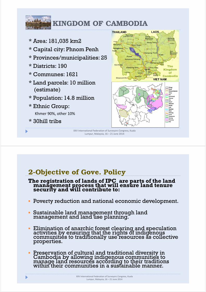
KINGDOM OF CAMBODIA
* Area: 181,035 km2
* Capital city: Phnom Penh
* Provinces/municipalities: 25
* Districts: 190
* Communes: 1621
* Land parcels: 10 million
(estimate)
* Population: 14.8 million
* Ethnic Group:
Khmer 90%, other 10%
* 30hill tribs
2-Objective of Gove. PolicyThe registration of lands of IPC are parts of the land
management process that will ensure land tenure security and will contribute to:
� Poverty reduction and national economic development.
� Sustainable land management through land management and land use planning.
� Elimination of anarchic forest clearing and speculation activities by ensuring that the rights of indigenous communities to traditionally use resources as collective properties.
� Preservation of cultural and traditional diversity in Cambodia by allowing indigenous communities to manage land resources according to their traditions within their communities in a sustainable manner.
XXV International Federation of Surveyors Congress, Kuala
Lumpur, Malaysia, 16 – 21 June 2014
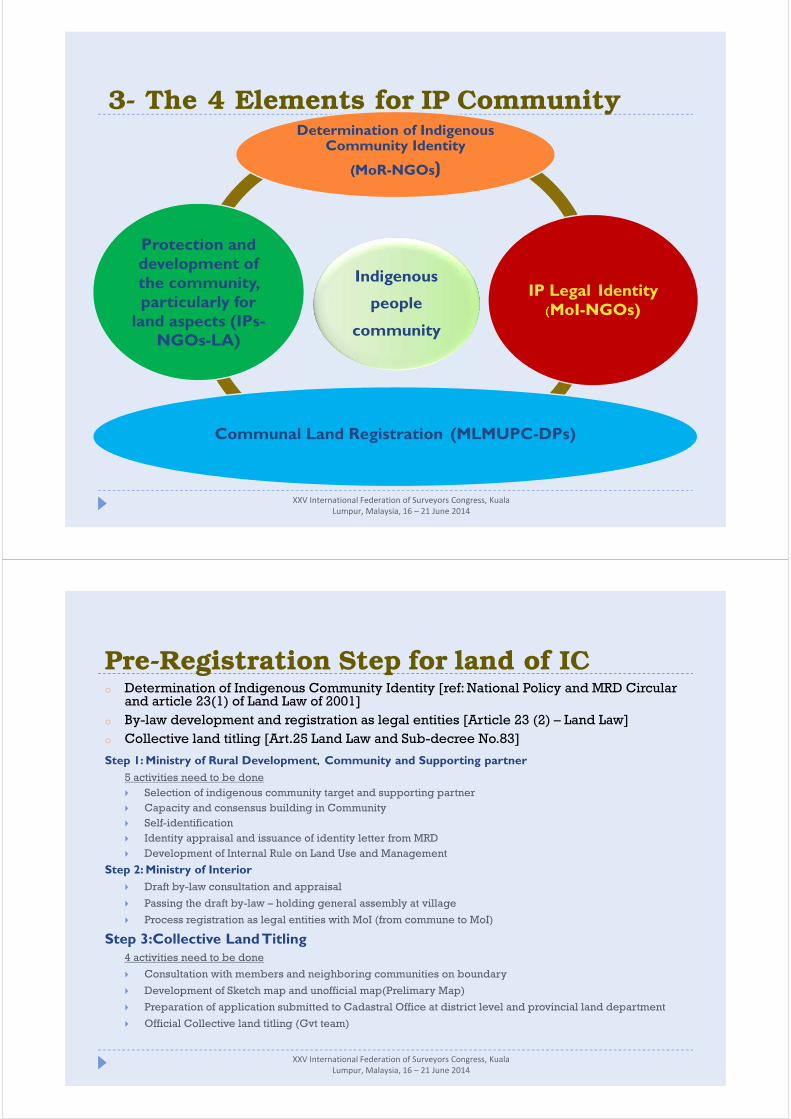
3- The 4 Elements for IP Community
Indigenous
people
community
Determination of Indigenous Community Identity
((((MoR-NGOs)
IP Legal Identity((((MoI-NGOs)
Communal Land Registration (MLMUPC-DPs)
Protection and development of the community, particularly for land aspects (IPs-NGOs-LA)
XXV International Federation of Surveyors Congress, Kuala
Lumpur, Malaysia, 16 – 21 June 2014
Pre-Registration Step for land of ICo Determination of Indigenous Community Identity [ref: National Policy and MRD Circular and article 23(1) of Land Law of 2001]
o By-law development and registration as legal entities [Article 23 (2) – Land Law]
o Collective land titling [Art.25 Land Law and Sub-decree No.83]
Step 1: Ministry of Rural Development, Community and Supporting partner
5 activities need to be done
� Selection of indigenous community target and supporting partner
� Capacity and consensus building in Community
� Self-identification
� Identity appraisal and issuance of identity letter from MRD
� Development of Internal Rule on Land Use and Management
Step 2: Ministry of Interior
� Draft by-law consultation and appraisal
� Passing the draft by-law – holding general assembly at village
� Process registration as legal entities with MoI (from commune to MoI)
Step 3:Collective Land Titling4 activities need to be done
� Consultation with members and neighboring communities on boundary
� Development of Sketch map and unofficial map(Prelimary Map)
� Preparation of application submitted to Cadastral Office at district level and provincial land department
� Official Collective land titling (Gvt team)
XXV International Federation of Surveyors Congress, Kuala
Lumpur, Malaysia, 16 – 21 June 2014

Pre-Registration Step for land of ICConsultation with members and
neighboring communities on boundary
Development
of Sketch map
& unofficial
map
( Prelimary
Map)
XXV International Federation of Surveyors Congress, Kuala
Lumpur, Malaysia, 16 – 21 June 2014
� Legal Framework Required
� Land Policy
� The Land Law (30 August, 2001)
� Policy on Registration of and Right to Use Lands of Indigenous Communities(24 April, 2009)
� Sub Decree No.118 on State Land Management, (07 October, 2005)
� Sub Decree No.83 on Procedures of Registration of Land of Indigenous Communities (09 June, 2009)
� Sub-decree on the sporadic and systematic land registration procedures(31 May, 2002)
XXV International Federation of Surveyors Congress, Kuala
Lumpur, Malaysia, 16 – 21 June 2014
4-Land Registration for IC

Lands eligible for registration as collective ownership of Community:
� State Private Lands include:
o Land on which the community has built houses (residential lands) and
o Land on which the community practices traditional agriculture (land actually cultivated
including rice fields and shifting cultivation land)
� State Public Land include:
o Lands reserve necessary for the sifting of cultivation which are recognized by the administrative authorities and agreed by the neighbors.
o Spiritual forest lands that can be one or more plots for each community
o Burial ground forest lands (cemeteries) that can be one or more plots for each community
Principles of Registration of Land of Indigenous Communities
o The registration of land of IC is the registration of all pieces of land of a community as collective ownership on a single cadastral map.
o The collective ownership certificate which will be issued to community should specify the name and location of the community, reference number to the single cadastral map indicating the location, size, boundary, co-ordinates of the land plot collectively owned and certification of the type of land use and other notes.
o Communities established as a legal entity with registered statute and official recognition can apply for land registration as collective title.
o Community shall be officially established as legal entity which has internal rule stipulating the management and collective land use as well as setting some conditions such as collective land management and land use according to land type and reconciliation at community level in case of conflict over traditional land use.
XXV International Federation of Surveyors Congress, Kuala
Lumpur, Malaysia, 16 – 21 June 2014
4-Land Registration for IC
4-Land Registration for IC
1.Preparation -Application Form-Interim Protection Measure-Information Dissemination
2.Technical Operation
A-Fieldwork
-State land identification
- Demarcation, Surveying and Adjudication
B-Office Work: Data entry , Digitizing,
3.Public Display of the Adjudicated Record
4.Public State Land Conversion to private state land
5.Issuance of Communal Land Title Certificates
XXV International Federation of Surveyors Congress, Kuala
Lumpur, Malaysia, 16 – 21 June 2014
� Land Registration step
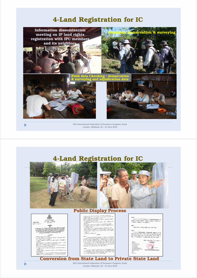
Information dissemination meeting on IP land rights
registration with IPC membersand its neighbors.
Boundary demarcation & surveying
Field data Checking : demarcation & surveying and adjudication data
XXV International Federation of Surveyors Congress, Kuala
Lumpur, Malaysia, 16 – 21 June 2014
4-Land Registration for IC
Conversion from State Land to Private State LandXXV International Federation of Surveyors Congress, Kuala
Lumpur, Malaysia, 16 – 21 June 2014
4-Land Registration for IC
Public Display Process
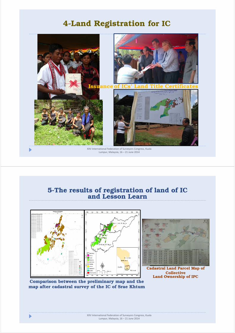
Issuanceof ICs’ Land Title Certificates
XXV International Federation of Surveyors Congress, Kuala
Lumpur, Malaysia, 16 – 21 June 2014
4-Land Registration for IC
Comparison between the preliminary map and the map after cadastral survey of the IC of Srae Khtum
XXV International Federation of Surveyors Congress, Kuala
Lumpur, Malaysia, 16 – 21 June 2014
Cadastral Land Parcel Map of Collective
Land Ownership of IPC
5-The results of registration of land of ICand Lesson Learn

5-The results of registration of land of ICand Lesson Learn
IPC Land Registration result till 2013
No.Province Name
District Name
Commune Name Village Name
Name of Community Family
Land Title
Total Size(ha)Others
1 RattanakiriKon Mum Teun Laeun Tum Pourn 118 47 1218.56O Chum O Chum Laeun Kren Tum Pourn 84 17 723.53
Sub total 2 202 64 1942.09
2 Mondulkiri
Sen MonorumAndong Kraleung
Pnong
112 37 1424.24
Keo Seima
Sre PreasOchra 27 27 526.12Gaty 45 22 482.69
Sre KtumO Ronaa 80 59 648.07Sre Lvi 36 13 383.84Sre Ktum 102 61 1084.47
Sub total 6 402 219 4549.43
Total 8 604 283 6491.52
OutcomeOutcomeOutcomeOutcome October,October,October,October,2013201320132013
�148 ICs have been listed as potential
for collective land titling
�95 ICs received Identity letter from MRD
�77 ICs registered as legal person
�8 ICs received collective land title
�Plan 10 ICs/Year
XXV International Federation of Surveyors Congress, Kuala
Lumpur, Malaysia, 16 – 21 June 2014
Regular M&E andquality control
Sufficient policyand legal
framework
Full andtransparent
financial support
Pilotproject
Officers’ capacity
building
Support form the
Government, the
Development Partners
and the NGOs
Modern technicalequipment
Good participationand cooperation
SUCCESS
5-The results of registration of IC’s land and Lesson Learn
XXV International Federation of Surveyors Congress, Kuala
Lumpur, Malaysia, 16 – 21 June 2014
6-Challenge 1. The community's understanding of the law, regulation and procedures of
registration still limited
2. Remote areas without proper and sufficient infrastructure resulted in difficulties to
undertake the fieldwork during rainy season and to have full participation.
3. Difficulties to demarcate and register as some areas were including many private
parcels.
4. IC land parcels are located sporadically in different villages and communes.
7-ConclutionGranting collective ownership on land to indigenous communities
provides them with a legal right to occupy and use, assures land
tenure security for the purpose of livelihood-support and of
increased agricultural products for the market.
XXV International Federation of Surveyors Congress, Kuala
Lumpur, Malaysia, 16 – 21 June 2014
អរគុណ THANK YOU
XXV International Federation of Surveyors
Congress, Kuala Lumpur, Malaysia, 16 – 21
June 2014