section iii: assessment forest-wide assessmentforestmanagement.co.beltrami.mn.us/portals/0/section...
TRANSCRIPT

Beltrami County Forestry Management Plan Assessment 16
Section III: Assessment
Forest-wide Assessment
Description Beltrami County has a diverse topography, gradually changing from rolling hills and lakes in the south to flat, low areas in the north. A great deal of the County is forested, containing mixed conifers and deciduous trees. Cultivated crop and pasturelands are largely concentrated in an area west and south of Lake Bemidji, across the center third of the County and on the western edge of the northernmost part of the County. A continental divide separates the drainage between the lowest third of the county and the upper two thirds. The area
Map 3-1
Beltrami County Forestry Management Plan Assessment 17
below this divide is a prime amenity area, consisting of recreational lakes, mixed conifer and deciduous forests, and most of the developed uses in the County. This area drains to the south and the Mississippi River. Between the continental divide and Red Lake is generally flatter terrain, providing land for cultivation, agriculture, and deciduous forests.
Most County-managed land is located in the southern part of the County, south of Lower Red Lake. For planning purposes, we will only deal with the management of County f4orest land in that area. Priority is placed on the active management of commercial stands over non-commercial cover types. All planning and operational management decisions are done on a per acre basis. Forest Cover Characteristics Beltrami County has historically been a key part of the timber producing region in northern Minnesota. Owing to this long history of harvest and regeneration, there is a broad array of cover types and age class distributions within the County’s forests. Notable issues within the County’s age class distribution include a disproportionate number of young (<25 year old) aspen stands; a significant number of acres of northern hardwoods in the 60-90 year old age classes; a disproportionate number of young (<25 year old) Norway pine stands; a significant number of mature jack pine stands; and a fairly well balanced age distribution of black spruce, tamarack, and white cedar stands. Additional detail on age class distribution for commercial cover types can be found in Table 3-1. A complete inventory of all county lands, including non-commercial stands, is found in table 3-2. More complete data on cover types and age classes can be found in the NRM databases. Each stand in the County’s forest is identified by its primary cover type, meaning that it is the most prevalent species within that stand. Intra-stand diversity is common in Beltrami County forests, and will continue to be. Forest managers have traditionally provided for and encouraged intra-stand diversity, while setting overall stand management goals based on the primary cover type.
In most cases throughout this document, cover type inventory data are presented for commercial cover types only.

Beltrami County Forestry Management Plan Assessment 18
Table 3-1 - County Acres of Commercial Forest by age class by primary stand cover type
COVER TYPE 1-10 11-20 21-30 31-40 41-50 51-60 61-70
71-90 91-110
111-130 131 + Grand Total
Ash 28 24 128 120 92 203 332 822 718 210 148 2705 Lowland Hardwoods 7 104 24 13 45 298 901 796 490 482 3160 Aspen 10374 15688 6842 2401 2503 4056 5613 3797 7 51281 Birch 5 16 46 19 40 152 491 1472 150 20 2411 Balm of Gilead 319 188 37 58 58 321 532 772 356 2641 Northern Hardwood 57 53 137 41 155 358 1468 5448 785 83 74 8659 Oak 8 4 71 8 11 134 651 153 1040 White Pine 123 38 3 5 84 123 45 421 Red Pine 2290 3828 1940 228 599 143 223 1386 1557 175 12369 Jack Pine 354 637 583 966 483 761 1365 813 1 5963 White Spruce 488 286 83 23 14 16 20 49 18 997 Balsam Fir 24 74 128 221 336 295 388 954 79 2499 Black Spruce 31 114 204 353 85 139 342 1197 1145 600 173 4383 Tamarack 16 191 320 516 308 214 230 1596 769 751 192 4893 Grand Total 14124 21245 10546 4946 4694 6719 11436 19942 6657 1351 365 103422
Important Note: Each stand is identified by its primary cover type, meaning that it is the most prevalent species within that stand. Intra-stand diversity is common in Beltrami County forests, and will continue to be. Forest managers will provide for and encourage intra-stand diversity, while setting overall stand management goals based on the primary cover type.

Beltrami County Forestry Management Plan Assessment 19
Table 3-2 - Inventory of all county lands, including non-commercial stands
Covertype Number Covertype
Acres
1 Ash 2873 9 Lowland Hardwoods 3193 12 Aspen 52978 13 Birch 2560 14 Balm of Gilead 2663 20 Northern Hardwoods 9049 30 Oak 1040 40 Central Hardwoods 7 51 White pine 436 53 Jack Pine 6069 52 Norway pine 12697 54 Scotch pine 1 61 White spruce 997 62 Balsam fir 2573 71 Black Spruce (lowland) 4440 73 White Cedar 5230 75 Stagnant Spruce –SI 22 or less 121 76 Stagnant Tamarack – SI 22 or less 53 77 Stagnant Cedar -- 569 78 Offsite Aspen – SI 34 or less 3 82 Cutover area 3523 83 Lowland Grass 3761 84 Upland Grass 994 85 Lowland Brush 11658 86 Upland Brush 207 91 Agriculture 612 92 Industrial Develop 250 93 Recreation Develop 74 94 Roads 224 95 Rock Outcrop 10 96 Permanent Water 1513 97 Non-permanent Water 5945 98 Marsh 5702 99 Muskeg 398 Total 142423

Beltrami County Forestry Management Plan Assessment 20
Ecological Classifications Descriptions of the County’s ecological classifications can be found in the Ecosystem Unit Analysis subsection. Forester Management Direction Beltrami County Natural Resource Management’s mission is to responsibly manage the approximate 147,000 acres of tax forfeited lands in Beltrami County in a sustainable manner that benefits the citizens of the County. The department is committed to a sustainable harvest and multiple use management of its lands. It also recognizes the impacts its activities can have on aesthetics, wildlife, riparian areas, cultural resources, soils, and water quality. As this is the first long-term County Forest Management Plan, no previous detailed strategic direction for the County’s forest was available to establish a performance baseline. An extensive interview process was undertaken to identify the existing management direction established for each district and the forest as a whole. Each member of the NRM staff was interviewed to identify their understanding of the overall vision, issues and opportunities for the department, as well as their personally-identified desired future forest condition for their district. This section summarizes and analyzes the results of that process for the overall forest. Specific management opportunities and challenges for each district are identified in Section IV. Where appropriate, managers are looking at managing more for natural-type forests and less for homogeneous plantations overall. Benchmarks include managing for a balanced-age forest with a greater diversity of cover type. The County’s capacity for additional silvicultural techniques would increase. Adoption of the County-wide plan will assist in the understanding and cooperation between district managers in growing a healthy forest.
The Forester Management Direction provided here outlines how the County NRM department has operated and managed lands under its care to date. Section IV provides guidance for how the forest will be managed after the adoption of this plan.
Current harvest techniques vary, depending on the existing cover type, the desired regeneration cover type and surrounding stands.

Beltrami County Forestry Management Plan Assessment 21
Immediate management issues include the difficulty of pine plantation regeneration due to the high deer population, as well as beaver control. Recreational use, including
permanent deer stands and motorized vehicle use, is becoming more of an issue. Technology and process improvements within the departmental the information flows within the office, improving the department’s capacity to manage the forest. Overall, NRM staff was of the opinion that the
district management philosophy works well, especially as additional capacity is added to deal with recreation and special use areas. This system works because it provides an opportunity for each forester to take ownership of their particular area, share special expertise with other foresters that helps them deal with their issues, and enhances accountability. Issues with this system focused around the lack of an overall vision for the County’s forest resources to help guide the foresters in any particular direction.
Beaver damage is a major problem for Beltrami County forest managers
Pine forest regeneration techniques in areas of heavy deer predation include bud capping, fencing and repellant sprays.
Map 3-2
Beltrami County Forestry Management Plan Assessment 22
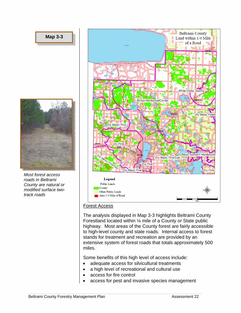
Forest Access The analysis displayed in Map 3-3 highlights Beltrami County Forestland located within ¼ mile of a County or State public highway. Most areas of the County forest are fairly accessible to high-level county and state roads. Internal access to forest stands for treatment and recreation are provided by an extensive system of forest roads that totals approximately 500 miles. Some benefits of this high level of access include: • adequate access for silvicultural treatments • a high level of recreational and cultural use • access for fire control • access for pest and invasive species management
Map 3-3
Most forest access roads in Beltrami County are natural or modified surface two-track roads

Beltrami County Forestry Management Plan Assessment 23
A few of the issues associated with this level of access include: • Illegal activities and uses • Increased incidence of human-caused wild fire • Weed dispersal • Habitat/stand fragmentation • Potential for damage from non-management use • Maintenance costs More information on the impact of roads on the forest ecosystem can be found in the US Forest Service document Roads Analysis: Informing Decisions About Managing the National Forest Transportation System located at http://www.fs.fed.us/eng/road_mgt/DOCSroad-analysis.shtml. District 1 Assessment
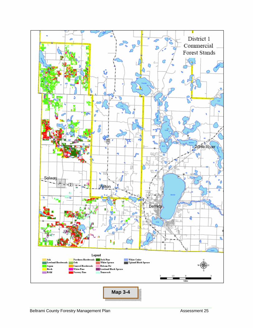
Description District 1 covers the western edge of Beltrami County, including the City of Solway and towns of Debs and Pinewood, with Roosevelt, Buzzle, Lammers, Jones and Grant Valley Townships. This area is sparsely populated, with most development located along U.S. Highway 2 and CSAH 5. This district contains significant portions of the Mississippi and Clearwater Rivers. Recreation and other non-timber issues are important in this district. Forest Cover Characteristics The predominant cover type in this district is Aspen (39%), followed by Norway Pine (20%) and Jack Pine (11%). Notable issues include a fairly young population (<20 years old) of Aspen; and an aging population of Jack Pine.
District 1 Commercial Cover Type
Cover Type Total Acres
Ash 118 Lowland
Hardwoods 653 Aspen 9749 Birch 808
Balm of Gilead 308
Northern Hardwood 893
Oak 261 White Pine 83 Red Pine 5096 Jack Pine 2808
White Spruce 524
Balsam Fir 1009 Black
Spruce Tamarack 1217
White Cedar 10 COA 1765
Grand Total 25302
Important Note: Each stand is identified by its primary cover type, meaning that it is the most prevalent species within that stand. Intra-stand diversity is common in Beltrami County forests, and will continue to be. Forest managers will provide for and encourage intra-stand diversity, while setting overall stand management goals based on the primary cover type.

Beltrami County Forestry Management Plan Assessment 24
Landscape Ecosystems The three landscape ecosystems found in this district include Dry Pine, Dry Mesic Pine, and Dry Mesic Pine/Oak. There are approximately 7874 acres of wetland in this district, which covers over 38,500 acres Current Forester Management Direction Long range efforts include the management of plantations for long term development. This district should look substantially more like a natural appearing landscape promoting a mixture of species and maintaining diversity. Management style includes designing timer sales that mimic a natural disturbance yet achieve forest management goals by removing targeted over-mature trees and implementing wildlife habitat guidelines where practical. Immediate issues include dealing with a jack pine budworm infestation over the past few years. In part due to a significant deer population, there are regeneration issues in pine plantations. There is also a disproportionate amount of older jack pine, without much middle age jack pine.
Wetland Class
District 1
Acres1 32 6663 11004 415 4296 22677 2588 302790 83
Grand Total 7874
Forest Manager
District 1 Acres
City 3.8County 32891.07State 5653.73United States 18.81Grand Total 38567.41
One of the issues in this and other districts is the failure of pine plantations due to deer browse and drought conditions
Beltrami County Forestry Management Plan Assessment 25
Map 3-4
Beltrami County Forestry Management Plan Assessment 26
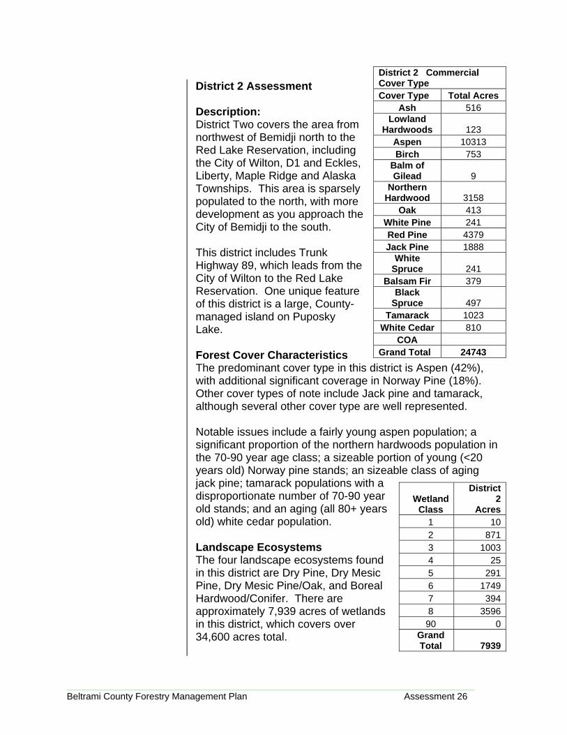
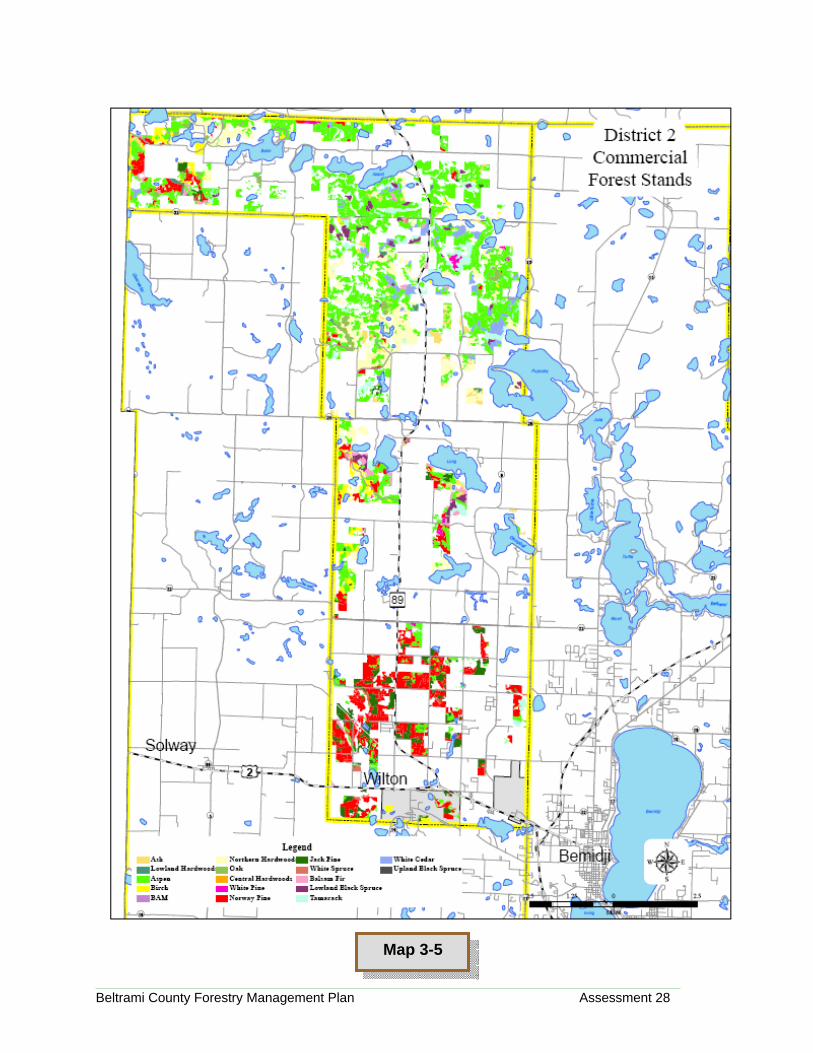
District 2 Assessment Description: District Two covers the area from northwest of Bemidji north to the Red Lake Reservation, including the City of Wilton, D1 and Eckles, Liberty, Maple Ridge and Alaska Townships. This area is sparsely populated to the north, with more development as you approach the City of Bemidji to the south. This district includes Trunk Highway 89, which leads from the City of Wilton to the Red Lake Reservation. One unique feature of this district is a large, County-managed island on Puposky Lake. Forest Cover Characteristics The predominant cover type in this district is Aspen (42%), with additional significant coverage in Norway Pine (18%). Other cover types of note include Jack pine and tamarack, although several other cover type are well represented. Notable issues include a fairly young aspen population; a significant proportion of the northern hardwoods population in the 70-90 year age class; a sizeable portion of young (<20 years old) Norway pine stands; an sizeable class of aging jack pine; tamarack populations with a disproportionate number of 70-90 year old stands; and an aging (all 80+ years old) white cedar population. Landscape Ecosystems The four landscape ecosystems found in this district are Dry Pine, Dry Mesic Pine, Dry Mesic Pine/Oak, and Boreal Hardwood/Conifer. There are approximately 7,939 acres of wetlands in this district, which covers over 34,600 acres total.
District 2 Commercial Cover Type Cover Type Total Acres
Ash 516 Lowland
Hardwoods 123 Aspen 10313 Birch 753
Balm of Gilead 9
Northern Hardwood 3158
Oak 413 White Pine 241 Red Pine 4379 Jack Pine 1888
White Spruce 241
Balsam Fir 379 Black
Spruce 497 Tamarack 1023
White Cedar 810 COA
Grand Total 24743
Wetland Class
District 2
Acres1 102 8713 10034 255 2916 17497 3948 359690 0
Grand Total 7939

Beltrami County Forestry Management Plan Assessment 27
Current Forester Management Direction The goal of this district is to develop a younger, healthier forest. Past practice has been geared towards the regeneration of the existing cover type once a stand has been harvested. Management style has been to operate within the framework of the allowable cut wherever possible while harvesting the worst stands (i.e. unproductive, old “falling apart” stands) first. Within that framework, the forester is trying to reduce edge and create more interior space with larger cuts. Immediate issues include dealing with a jack pine budworm infestation over the past few years. This district has lots of old jack pine stands that need to be regenerated. Road maintenance in the clay soils, deer stands and motorized recreation access are other issues in this district.
Forest Manager
District 2 Acres
City 103.56County 32303.82State 2130.56United States 145.73Grand Total 34683.67
Remnants of old deer stands, including the nails used to attach them, can make otherwise merchantable trees unharvestable
Beltrami County Forestry Management Plan Assessment 28
Map 3-5

Beltrami County Forestry Management Plan Assessment 29
District 3 Assessment
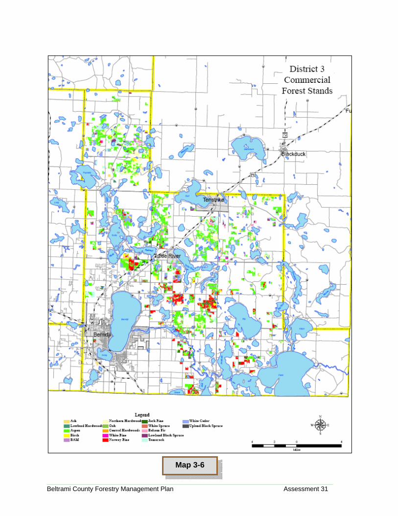
Description: District 3 covers the most heavily populated portions of Beltrami County, including the City of Bemidji, the lakes area north of Bemidji and portions of the Leech Lake reservation and Chippewa National Forest. This area includes Bemidji, Frohn, Ten Lake, Brook Lake, Sugar Bush, Turtle River, Northern, Turtle Lake, Port Hope, Taylor, Durand and Nebish Townships, as well as the Cities of Bemidji, Turtle River, and Tenstrike and the Nebish community. This district contains large portions of the Mississippi and Turtle River corridors in the County. Recreation is a major consideration when managing forests in this district. Forest Cover Characteristics The predominant cover types in this district include aspen (43%) and Northern Hardwood (15%), as well as Norway Pine (11%). Notable issues include a fairly young population (<20 years old) of aspen; a notable population of 60-80 year old northern hardwoods; an uneven age population of Norway pine (high in both <30 age and the 70-80 year old cohorts); and aging populations of tamarack and white cedar. Landscape Ecosystems The four landscape ecosystems found in this district include Dry Mesic Pine/Oak, Boreal Hardwood/Conifer, and small areas of Dry Pine and Mesic Northern Hardwoods. There are approximately 11,331 acres of wetland in this district, which covers
District 3 Commercial Cover Type
Cover Type Total Acres
Ash 349 Lowland
Hardwoods 157 Aspen 11479 Birch 625
Balm of Gilead 198
Northern Hardwood 3927
Oak 363 White Pine 148 Red Pine 2885 Jack Pine 976
White Spruce 301
Balsam Fir 495 Black
Spruce 831 Tamrack 1737
White Cedar 2021 COA 312
Grand Total 26804
Wetland Type
District 3 Acres
1 842 7823 15874 495 6686 29167 4128 482590 8
Grand Total 11331
Beltrami County Forestry Management Plan Assessment 30
over 97,800 acres.
Current Forester Management Direction Past management direction included continuing and improving upon species and age diversity within the forest. Management style included managing harvest activities carefully in the developed areas of the district while providing for a sustainable forest. There was a desire to find ways to better manage longer rotation species. Immediate issues included the management of County parks and recreation lands within the district, which was difficult to accomplish within the natural resources management framework. Regeneration of pine stands is an issue in all areas.
Forest Manager
District 3 Acres
City 145.5 County 37917.28 State 19825.42 United States 39914.22 Grand Total 97802.42
Most of the currently-designated recreation areas in the County are in this district
Beltrami County Forestry Management Plan Assessment 31
Map 3-6

Beltrami County Forestry Management Plan Assessment 32
District 4 Assessment
Description: District four covers the eastern and northern portions of the County, including the Cities of Blackduck, Kelliher and Funkley as well as the edges of the Leech Lake Reservation and Chippewa National Forest. Townships include Moose Lake, Birch, Summit, Hines, Hagali, O’Brien, Langor, Hornet, Quiring, Cormant, and Shooks. The population of this area has been fairly stable for generations, allowing for the establishment of good working relationships between staff and residents. Topography in this area includes more low land and rivers but fewer lakes. This district is the largest aspen producing district in the County. Forest Cover Characteristics The predominant cover type in this district is Aspen (57%). Populations of Elm, Balm of Gilead, black spruce and white cedar can also found in this district. Notable issues include an aging elm population (mostly >60 years old); a young population (<20 years old) of aspen stands; and a balanced but aging population of white cedar. Landscape Ecosystems The landscape ecosystems classification found in this district is Boreal Hardwoods/Conifer, supplemented by White Cedar Swamp and a small area of Dry Mesic Pine/Oak. There are approximately 19,751 acres of wetland in this district, which covers nearly 97,000 acres.
District 4 Commercial Cover Type
Cover Type Total Acres
Ash 1844 Lowland
Hardwoods 2227 Aspen 19788 Birch 225
Balm of Gilead 2126
Northern Hardwood 703
Oak 3 White Pine Red Pine 392 Jack Pine 751
White Spruce 20
Balsam Fir 617 Black
Spruce 1731 Tamarack 1254
White Cedar 2847 COA 354
Grand Total 34882
Wetland Type
District 4 Acres
1 9572 3313 28084 1485 1256 73077 18648 609080 10390 18
Grand Total 19751

Beltrami County Forestry Management Plan Assessment 33
Current Forester Management Direction Long range efforts are geared towards the creation of a better age class distribution over four or five classes, reducing significantly the old aspen population. The natural regeneration of aspen stands provides excellent cover for wildlife.
Management style is geared towards regeneration of aspen so as to create a more even, sustainable age structure across the forest. Significant consideration is given towards production areas for wildlife and game animals. Immediate issues are minimal in this district.
Forest Manager
District 4 Acres
City 524.76County 46601.67State 21104.9United States 28754.45Grand Total 96985.78
Young aspen stands such as this one are a major component of sustainable aspen forest in this district, while providing excellent wildlife habitat

Beltrami County Forestry Management Plan Assessment 34
Map 3-7

Beltrami County Forestry Management Plan Assessment 35
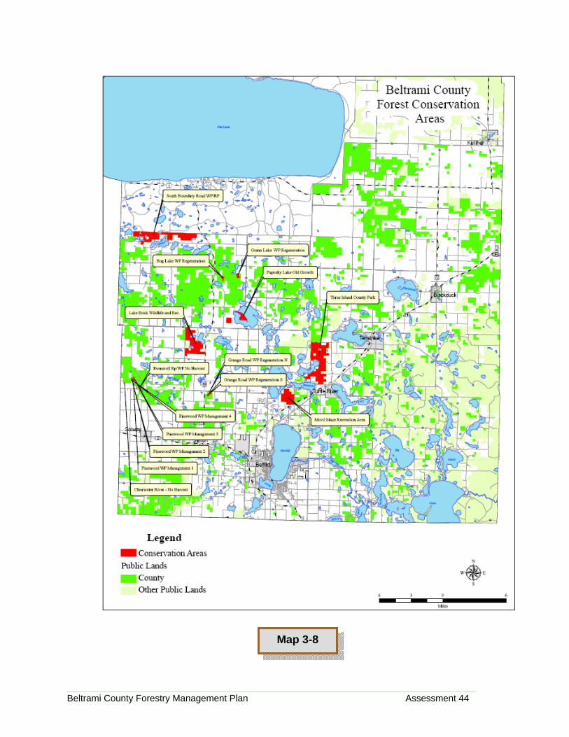
Conservation and Special Management Areas Within County Forestland, there are areas that merit special consideration for management purposes. Some areas are geared for recreational use; some are managed for wildlife production; others have natural attributes that makes them particularly suited for a specific management purpose. These areas are described here briefly. Each area has a more fully developed Conservation Area Management Plan on file in the NRM office. A map is attached identifying these areas. Individual consideration was given to each area in the development of its plan. Conservation Area Puposky Lake Old Growth Site Size 392 Acres Description of Site and Special Attributes This area is dominated by northern hardwood types and lowlands, containing marshes, tamarack, black spruce and ash. The most unique thing about this area is the 200 plus acre island on Puposky Lake which is completely under public ownership. Access to these parcels is limited by either private property or by water and contains no evidence of a trail system. The timber management plan at this time is to do no harvesting of any kind on Puposky Lake Island and to keep the timber stand in the private access area in extended rotation. History of Site and Adjacent Management Activity There is no evidence of any trail system. Management Restrictions Within the Conservation Area There will be no harvesting of timber on Puposky Island, and the stands in Section 35 will be managed on extended rotation. Conservation Area: South Boundary Road Pine Management Study Area Size: 2086 Acres Description of Site and Special Attributes This area is the county managed land along the south boundary of the Red Lake Reservation lying west of Minnesota Highway 89. The land is dominated by several cover types including aspen, northern hardwoods, and white
Conservation Area Description:
Puposky Lake Old Growth Site
Conservation Area Description:
South Boundary Road Pine
Management Study Area
Policy LD-P54 sets a comprehensive and coordinated program to protect areas of special ecological, geological, cultural, historical or social significance.
Beltrami County Forestry Management Plan Assessment 36
and Norway (red) pine. There is a white pine regeneration study area within this corridor to help establish the white pine as a dominant pine within this forest ecosystem. The main objective in this area is to encourage the perpetuation of mature white and Norway pine by the use of extended rotation, reforestation and special reserve areas.
Specific Management Requirements Stands will be pruned, and thinned to perpetuate and encourage large red pine and white pine trees. Management Restrictions Within the Conservation Area The final harvest will be based on perpetuating the long term white and red pine cover types. Conservation Area: Grenn Lake White Pine
Regeneration Study Area Size: 75 Acres Description of Site and Special Attributes Forest cover types of this conservation area are mixed between white pine, northern hardwoods and aspen. With mature white pine scattered throughout this area and two main clusters of white pine to the north and south. The main trail into this area crosses over private land which limits its access to the public. The land is mostly used by local residents for hunting and recreational activities. The county does have a timber management easement to access across private land. History of Site and Adjacent Management Activity There have been occasional forest management activities which have provided younger age classes in the aspen cover type, though the majority of the mature white pine was reserved. Specific Management Requirements Use silvicultural techniques appropriate for white pine management. Conservation Area: Lake Erick Wildlife Recreation Area Size: 1687 Acres Description of Site and Special Attributes This area is dominated by mature birch and northern hardwood types, with a scattering of Norway pine types. This
Conservation Area Description:
Grenn Lake White Pine Regeneration
Study Area
Conservation Area Description:
Lake Erick Wildlife Recreation Area

Beltrami County Forestry Management Plan Assessment 37
area also has a diverse age group of aspen along with other upland and lowland cover types. The terrain is rolling with scattered wetlands throughout this area and is also bordered by two lakes and a wildlife management area. Several recreational trails cross through the forest and onto adjoining private lands with the main trail coming into this area off highway 89. This area is the access point to a primitive boat landing on Lake Erick. It also has evidence of an old homestead that belonged to Ivar A. Rockvog (Liberty Township History, 1898-1998, page 181) along the south shore of Deer Lake.
This parcel has been nominated as a Conservation Area due to its recreation potential, its close proximity to Bemidji, and its access point off a major highway. The main access into this area is from highway 89 up to Lake Erick boat access, with secondary trails leading off the main trail. This area offers a great opportunity for a variety of recreational activities along with forest development projects.
History of Site and Adjacent Management Activity There have been occasional forest management activities which have provided younger age classes. Specific Management Requirements Use silvicultural techniques appropriate for each forest cover type. Management Restrictions Within The Conservation Area Management options will be considered in conjunction with the recreational activities that may be affected or improved. Conservation Area: Clearwater River – No Harvest Site Size: 4 Acres Description of Site and Special Attributes This site is located along the banks of the Clearwater River which is a designated trout stream. The forest inventory indicates a jack pine cover type, but is now predominantly large white pine and red pine greater than 18 inches diameter. It also maintains a strong white pine under story. History of Site and Adjacent Management Activity
Conservation Area Description:
Clearwater River – No Harvest Site

Beltrami County Forestry Management Plan Assessment 38
The adjacent stand was harvested in 1994 and has been regenerated to jack pine. Specific Management Requirements Under story white pine may eventually be pruned and thinned to provide a healthy white pine cover type. Management Restrictions With The Conservation Area There will be no final harvest within this area. Conservation Area: Pinewood White Pine Management 1 Size 21 Acres Description of Site and Special Attributes The forest inventory indicates a jack pine cover type, but is now predominantly large white pine and red pine greater than 16 inches diameter. It also maintains a strong white pine under story. Specific Management Requirements Under story white pine may eventually be pruned and thinned to provide a healthy white pine cover type. Management Restrictions Within The Conservation Area There will be no final harvest within this area. Conservation Area: Pinewood White Pine Management 2 Size: 17 Acres Description of Site and Special Attributes This is a 17 acre white pine plantation that is approximately 15 years old in 2006 and a snowmobile trail runs through the center. Specific Management Requirements Under story white pine will be pruned and thinned to provide a healthy white pine cover type. Management Restrictions Within The Conservation Area There will be no final harvest within this area. Conservation Area: Pinewood White Pine Management 3 Size: 3 Acres
Conservation Area Description:
Pinewood White Pine Management 2
Conservation Area Description:
Pinewood White Pine Management 3
Conservation Area Description:
Pinewood White Pine Management 1
Beltrami County Forestry Management Plan Assessment 39
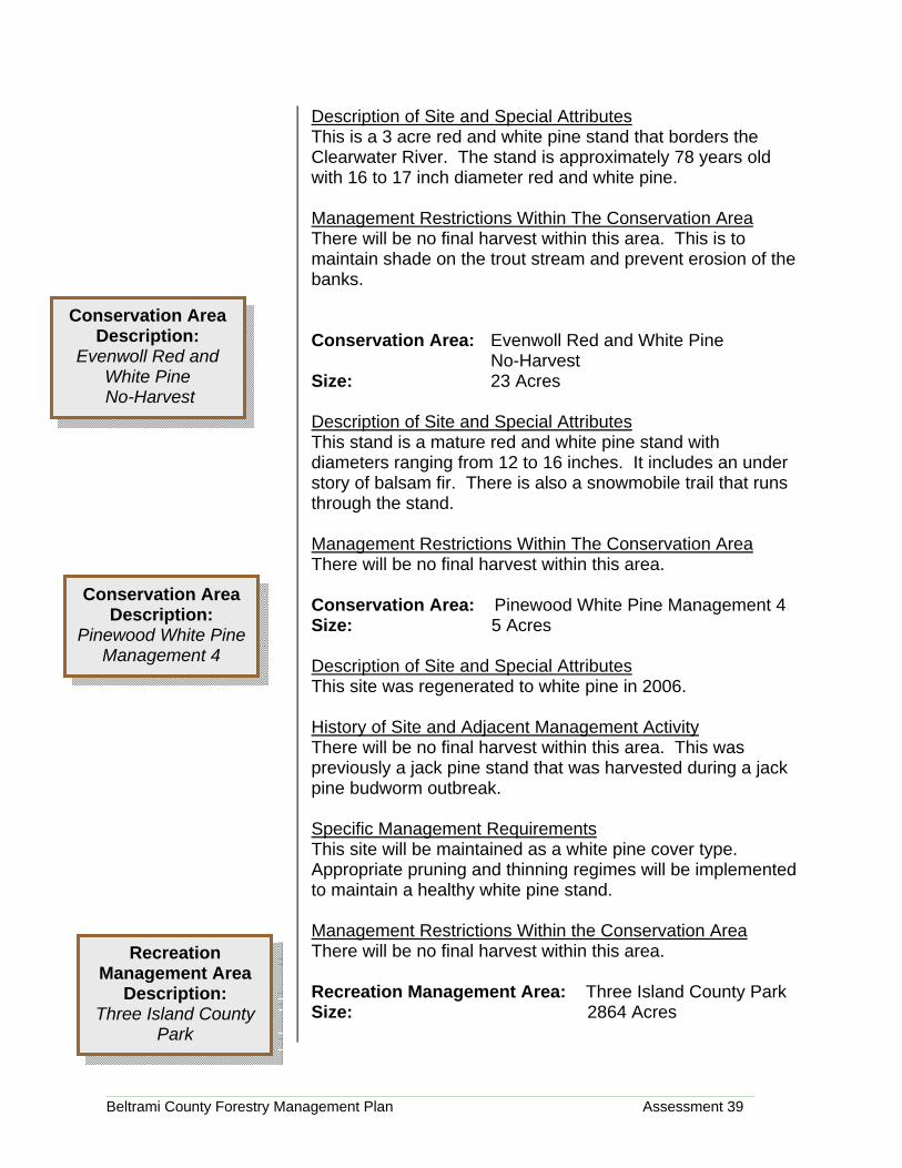
Description of Site and Special Attributes This is a 3 acre red and white pine stand that borders the Clearwater River. The stand is approximately 78 years old with 16 to 17 inch diameter red and white pine. Management Restrictions Within The Conservation Area There will be no final harvest within this area. This is to maintain shade on the trout stream and prevent erosion of the banks. Conservation Area: Evenwoll Red and White Pine No-Harvest Size: 23 Acres Description of Site and Special Attributes This stand is a mature red and white pine stand with diameters ranging from 12 to 16 inches. It includes an under story of balsam fir. There is also a snowmobile trail that runs through the stand. Management Restrictions Within The Conservation Area There will be no final harvest within this area.
Conservation Area: Pinewood White Pine Management 4 Size: 5 Acres Description of Site and Special Attributes This site was regenerated to white pine in 2006. History of Site and Adjacent Management Activity There will be no final harvest within this area. This was previously a jack pine stand that was harvested during a jack pine budworm outbreak. Specific Management Requirements This site will be maintained as a white pine cover type. Appropriate pruning and thinning regimes will be implemented to maintain a healthy white pine stand. Management Restrictions Within the Conservation Area There will be no final harvest within this area. Recreation Management Area: Three Island County Park Size: 2864 Acres
Conservation Area Description:
Evenwoll Red and White Pine No-Harvest
Conservation Area Description:
Pinewood White Pine Management 4
Recreation Management Area
Description: Three Island County
Park

Beltrami County Forestry Management Plan Assessment 40
Description of Site and Special Attributes Three Island County Park is located about fifteen miles northeast of Bemidji, on the east side of Three Island Lake, and is easily accessible from county roads. This are is managed for both its forest and recreational features. The topography, soils, and history are typical for this region of Minnesota, with characteristic northern hardwood, conifer, and aspen types. Wetlands cover about one-third of Three Island County Park. Predominate recreation use has been cross country skiing and snowmobiling in the winter months and hunting in the fall. State of Minnesota grant-in-aid ski trails and snowmobile trails are respectively groomed and maintained by the Bemidji Area Cross Country Ski Club and the North Country Snowmobile Club. Over 15 miles of ski trails lie within the park and are accessed by two parking areas. A snowmobile trail runs north and south through the park. A day-use area, formerly a campground, is located near the dam. Recreation Mangement Area: Movil Maze Recreation Area Size: 906 Acres Description of Site and Special Attributes Movil Maze Recreation Area is located approximately five miles northeast of Bemidji, on the east side of Movil Lake, and is easily accessible from county roads. This area is managed for both its forest and recreational features. The topography, soils, and history are typical for this region of Minnesota, with characteristic northern hardwood, conifer, and aspen types. Predominate recreation use has been cross country skiing and snowmobiling in the winter months and hunting in the fall. State of Minnesota grant-in-aid ski trails and snowmobile trails are respectively groomed and maintained by the Bemidji Area Cross Country Ski Club and the North Country Snowmobile Club. Forest Management Both Three Island County Park and Movil Maze Recreation area provide excellent outdoor recreational opportunities. They will retain their importance as prime recreational areas, but will also continue to be managed as productive forest land. There will be an increase of importance placed on educating the recreational users of forest practices that are essential to maintaining a healthy and productive forest.
Recreation Management Area
Description: Movil Maze

Beltrami County Forestry Management Plan Assessment 41
also critical to manage the forests promote economic viability and community stability.
• All forest management activities will adhere to the same
standards set forth in Beltrami County’s Sustainable Forest Management System as identified in the Sustainable Forest Management Policy (LD-PI) and statement of operational commitments (LD-P2) (County-wide NRM Objective and Policies Section IV Page 73).
o Continually improve performance of the SFMS through regular review and audits.
• All practices shall be considerate of the recreational
activities occurring on the site. • Appropriate silvicultural techniques will be applied to the
major cover types, which include aspen, northern hardwoods, pine, lowland conifers and hardwoods.
• Long term and short term tactical plan will be addressed within Beltrami County’s Forest Planning and Recreational Facilities Planning processes.
• Revenues for timber harvesting are necessary and will be used to support park and recreation development and maintenance.
Hunting and Trapping Hunting and trapping are regarded as an essential forest and wildlife management tool as well as an appropriate form or recreation in Three Island County Park. Minnesota Department of Natural Resources hunting and trapping rules and regulations will apply.
• Only temporary deer stands are allowed with Three
Island County Park and Movil Maze Recreation Area. • Temporary deer stands allowed between September 1
and December 31 depending on their respective hunting season.
• All stands must be removed by the end of their respective hunting seasons.
• Hunters should minimize damage to trees and vegetation.
• Cutting of shooting lanes is prohibited • ATVs/snowmobiles shall be permitted during the
firearms deer season in accordance with DNR regulations and definitions.
Beltrami County’s Sustainable Forest Management Policy (LD-P1) was adopted by the County Board on May 2, 2006. That and other detailed operational policies can be accessed at the NRM offices.

Beltrami County Forestry Management Plan Assessment 42
• During the firearms deer season, other recreation uses will be discouraged for safety reasons. Blaze orange clothing is suggested for all park users.
Access Control • To be evaluated and reviewed in development of Park
and Facilities plan of three Island County Park • As the forest is managed and timber harvested, existing
forest access routes and recreation trails may on occasion have to be realigned or restricted to accommodate forest management activities, including those that are commonly used for informal recreational activities. In these instances NRM staff will seek input from user groups to determine how routes should be altered to accommodate each others needs, with the intent being alignments that accommodate both timber harvesting and recreational use whenever feasible. NRM staff will also communicate any changes to the user groups.
Management Restrictions Within The Conservation Area Considerations for: Forest management and all development activities will identify, enhance and protect to the greatest extent possible the: • Turtle River • Three Island Lake • Historic Dam Site • Trail System • Potential Facility Development Area • Identified Cultural Resources and Natural Heritage
Elements • Ruffed Grouse Management Area
Management Options Within The Area The northern half of Three Island County Park will continue to be managed as a ruffed grouse management area. This will be accomplished through smaller harvest sites in the aspen cover type stand (5-15 acres), cooperation with Minnesota DNR Wildlife, and the Minnesota Ruffed Grouse Society. All trails within this area except the designated ATV/Snowmobile trail are designated as hunter walking trails from May 1 through December 1.
Beltrami County Forestry Management Plan Assessment 43
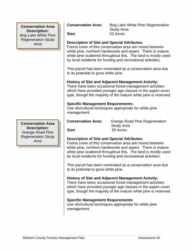
Conservation Area: Bog Lake White Pine Regeneration Study Area Size: 53 Acres Description of Site and Special Attributes: Forest cover of this conservation area are mixed between white pine, northern hardwoods and aspen. There is mature white pine scattered throughout this. The land is mostly used by local residents for hunting and recreational activities. This parcel has been nominated as a conservation area due to its potential to grow white pine. History of Site and Adjacent Management Activity: There have been occasional forest management activities which have provided younger age classes in the aspen cover type, though the majority of the mature white pine is reserved. Specific Management Requirements: Use silvicultural techniques appropriate for white pine management. Conservation Area: Grange Road Pine Regeneration Study Area Size: 55 Acres Description of Site and Special Attributes: Forest cover of this conservation area are mixed between white pine, northern hardwoods and aspen. There is mature white pine scattered throughout this. The land is mostly used by local residents for hunting and recreational activities. This parcel has been nominated as a conservation area due to its potential to grow white pine. History of Site and Adjacent Management Activity: There have been occasional forest management activities which have provided younger age classes in the aspen cover type, though the majority of the mature white pine is reserved. Specific Management Requirements: Use silvicultural techniques appropriate for white pine management.
Conservation Area Description:
Bog Lake White Pine Regeneration Study
Area
Conservation Area Description:
Grange Road Pine Regeneration Study
Area
Beltrami County Forestry Management Plan Assessment 44
Map 3-8