section 5 architecture of a system of … geoss 10-year implementation plan – reference document...
TRANSCRIPT
Draft GEOSS 10-Year Implementation Plan – REFERENCE DOCUMENT IPTT 201-1 Section 5 – ARCHITECTURE OF A SYSTEM OF SYSTEMS S.5
SECTION 5 ARCHITECTURE OF A SYSTEM OF SYSTEMS
2509 2510
5 A System of Systems 2511
2512 2513 2514
2515
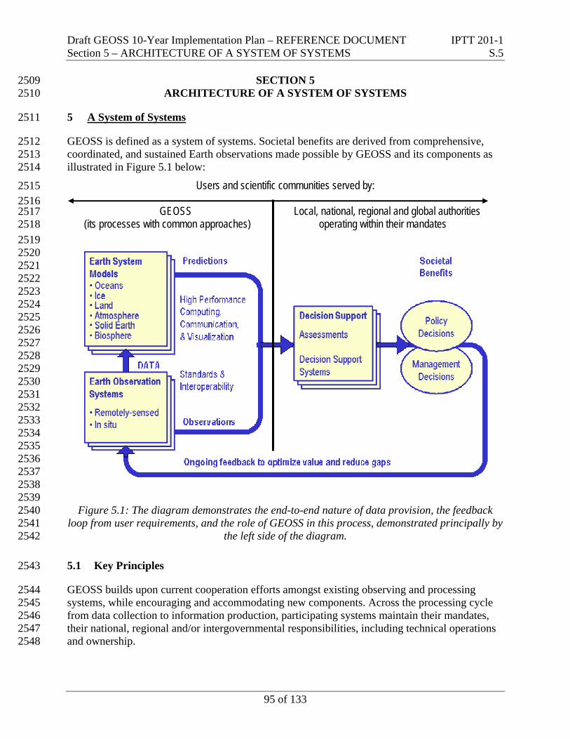
GEOSS is defined as a system of systems. Societal benefits are derived from comprehensive, coordinated, and sustained Earth observations made possible by GEOSS and its components as illustrated in Figure 5.1 below:
Users and scientific communities served by:
GEOSS Local, national, regional and global authorities (its processes with common approaches) operating within their mandates
2516 2517 2518 2519 2520 2521 2522 2523 2524 2525 2526 2527 2528 2529 2530 2531 2532 2533 2534 2535 2536 2537 2538 2539 2540 2541 2542
2543
2544 2545 2546 2547 2548
Figure 5.1: The diagram demonstrates the end-to-end nature of data provision, the feedback loop from user requirements, and the role of GEOSS in this process, demonstrated principally by
the left side of the diagram.
5.1 Key Principles
GEOSS builds upon current cooperation efforts amongst existing observing and processing systems, while encouraging and accommodating new components. Across the processing cycle from data collection to information production, participating systems maintain their mandates, their national, regional and/or intergovernmental responsibilities, including technical operations and ownership.
95 of 133
Draft GEOSS 10-Year Implementation Plan – REFERENCE DOCUMENT IPTT 201-1 Section 5 – ARCHITECTURE OF A SYSTEM OF SYSTEMS S.5
2549 2550 2551 2552 2553 2554
2555 2556 2557 2558
2559 2560 2561
2562 2563
2564 2565
2566 2567
2568 2569 2570
2571 2572
2573 2574 2575
2576 2577
2578
2579
2580 2581
For required new components, GEOSS participants will establish, encourage establishment, or find an organizational entity already existing, to be responsible. GEOSS participants may also possibly need coordination with commercial, academic, and other non-government organizations. Local, national, regional and global authorities, operating within their mandates, may access and utilize GEOSS data and products in the preparation and issuance for guidance resulting in societal benefits.
Section 6 describes how GEOSS component strategies and systems fit together to produce a comprehensive, coordinated, and sustained system of systems that better satisfies overall requirements in the identified societal benefit areas. The GEOSS Implementation Plan addresses not only cost effectiveness and technical feasibility, but also institutional feasibility.
The architectural approach for the GEOSS 10-year Implementation Plan builds on existing systems and historical data, as well as existing documentation describing observational needs in these areas. GEOSS is based on several key principles:
• GEOSS is to be driven by user needs, support a broad range of implementation options, and be able to incorporate new technology and methods;
• GEOSS is to address planned and operational observation systems required for participants to make products, forecasts and related decisions;
• GEOSS is to include observing, processing, and dissemination capabilities interfaced through interoperability specifications agreed and adhered to amongst all participants;
• GEOSS observations and products are to be observed, recorded and stored in clearly defined formats, with metadata and quality indications to enable search and retrieval, and archived as accessible data sets;
• GEOSS is to provide a framework for securing the future continuity of observations and the instigation of new observations; and,
• GEOSS participants and the components they support are to be documented in a catalogue that is publicly accessible, network distributed, and interoperable with major Earth observations catalogues;
• GEOSS will work closely with research initiatives that may use GEOSS data and products as well as improve the effectiveness of future observing systems.
5.2 Functional components
GEOSS is comprised of three types of functional components:
• Components to acquire observations based on existing local, national, regional and global systems to be augmented as required by new observing systems;
96 of 133

Draft GEOSS 10-Year Implementation Plan – REFERENCE DOCUMENT IPTT 201-1 Section 5 – ARCHITECTURE OF A SYSTEM OF SYSTEMS S.5
2582 2583 2584 2585 2586
2587 2588 2589 2590
2591 2592 2593 2594 2595 2596 2597
2598 2599 2600 2601 2602 2603 2604 2605 2606 2607 2608 2609
2610 2611 2612 2613
2614 2615 2616
2617 2618 2619 2620 2621
• Components to process data into useful information, i.e. geo-products that are part of GEOSS, recognizing the value of modeling, integration and assimilation techniques for example global sea-surface temperature fields - such geo-products will be prepared in those modeling centers participating in GEOSS and serve as input to the decision support systems required in response to societal needs; and
• Components required to exchange and disseminate observational data and information including those for archiving. Components are understood to include data management that encompasses issues such as QA/QC (Quality Assessment/Quality Control), access to data, and archiving of data and other resources.
In common with Spatial Data Infrastructures (SDI) and services-oriented information architectures, GEOSS system components are to be interfaced with each other through agreed interoperability specifications. Access to data and information resources of GEOSS will be accomplished through various service interfaces to be contained within the data exchange and dissemination component. The actual mechanisms will include many varieties of communications modes, with a primary emphasis on the Internet wherever appropriate but ranging from very low technology approaches to highly specialized technologies.
A key consideration is that GEOSS catalogues data and services with sufficient metadata information such that users can find what they need and gain access as appropriate. Internet is a primary medium for the mechanism to allow users to access the catalogue of available data and products, with hard copy media to also be available as appropriate. Users searching GEOSS catalogues will find descriptions of participants and the components they support, leading directly to whatever information is needed to access the specific data or service. In this sense, the interoperable GEOSS catalogues form the foundation of a more general clearinghouse. GEOSS data resources can be not only fully described in context, data access can be facilitated through descriptions of whatever analysis tools, user guides, and other services may be useful. Many examples of such clearinghouse facilities already exist in the realm of Earth observations and networked information systems generally, and many of these already employ interoperable interfaces.
GEOSS will develop a common set of guidelines for archiving. GEOSS will emphasize to participants that archive centers must have adequate funding to address data growth and be in a position to ensure the perpetuity of not only incoming data but also data safeguard on aging or obsolete media.
Historical data and data in developing countries are frequently kept on paper records in regional offices and their existence is not well known. The rescue of such data is important to strengthen and broaden the historical records for assessing trends.
GEOSS will promote the use of common mechanisms for the cataloguing of archives, including how to access them. All providers need to ensure that archived data and products provide a statement of the access conditions in terms of the mechanics and policies. There should also be a well-documented statement of the ancillary data needed to understand and use basic data sets and products.
97 of 133
Draft GEOSS 10-Year Implementation Plan – REFERENCE DOCUMENT IPTT 201-1 Section 5 – ARCHITECTURE OF A SYSTEM OF SYSTEMS S.5 5.3 Convergence of Observations 2622
2623 2624 2625 2626 2627 2628 2629
2630 2631 2632
2633
2634 2635 2636 2637 2638
2639
2640 2641
2642 2643
2644 2645
2646 2647
2648
2649 2650 2651 2652
2653 2654 2655 2656
One of the goals of GEOSS is to establish a system of systems that can provide timely data and information for local, national, regional and international policy makers. Participating systems will provide real- or near real-time monitoring, early detection and globally integrated observations. Near real-time observations are required to address specific disaster needs (e.g., submarine seismic and volcanic activity and tsunami propagation) and significant extreme events in Agriculture (e.g., fire, forest conversion, forest concession management and land degradation hotspots).
Topic-specific integration of global observations is required by almost all of the identified societal benefit areas, but each area has a different balance between in situ and satellite observations.
5.4 Opportunities for Synergy
It is expected that there will be a large increase in the volume of Earth observation data. In addition to distributed data archives and integration systems, area-focused data management facilities will be used for diverse and large-volume Earth observation data from inhomogeneous information sources in cooperation with existing data centers that will keep their institutional identity and mandates. Thus, GEOSS will facilitate:
• Life-cycle data management for large volume data from leading-edge storage technology;
• Utilization of advanced database technology that enables multi-layered visualization of various types of data;
• Integration of natural science data and human societal data by standard co-registration techniques for data and geographic information;
• New value-added products resulting from information fusion of diverse and large volumetric Earth observation data;
• Implementation of international information sharing capabilities through an Internet-based service.
5.5 Interoperability Agreements
In order for interoperability to be broad and sustainable, fewer agreements accommodating many systems are preferred over many agreements accommodating few each. Interoperability should focus on interfaces, defining only how system components interface each other and thereby minimizing any impact on affected systems other than interfaces to the shared architecture.
Wherever possible, interoperability agreements must be based on non-proprietary standards, and profiles must be specified when standards are not sufficiently specific. Rather than defining new specifications, GEOSS should adopt standard specifications agreed upon voluntarily and by consensus, with preference to formal international standards such as ISO. All interface
98 of 133

Draft GEOSS 10-Year Implementation Plan – REFERENCE DOCUMENT IPTT 201-1 Section 5 – ARCHITECTURE OF A SYSTEM OF SYSTEMS S.5
2657 2658 2659 2660
2661 2662 2663 2664 2665 2666
2667 2668 2669 2670 2671 2672
2673 2674 2675 2676 2677
2678 2679 2680 2681
2682 2683 2684 2685 2686 2687
2688 2689 2690 2691 2692 2693 2694 2695
implementations should be specified in a platform-independent manner, and verified through interoperability testing and public demonstrations. In the instances cited below, the service standards are widely deployed in commercial products and are also available for free as open source software implementations.
GEOSS interoperability agreements are to be based on the view of complex systems as assemblies of components that interoperate primarily by passing structured messages over network communication services. By expressing interface interoperability specifications as standard service definitions, GEOSS system interfaces assure verifiable and scalable interoperability, whether among components within a complex system or among discrete systems.
GEOSS service definitions are to specify precisely the syntax and semantics of all data elements exchanged at the service interface, and fully describe how systems interact at the interface. At present, participants in GEOSS should agree to use any one of four open standard ways to describe service interfaces (CORBA, Common Object Request Broker Architecture; WSDL, Web Services Definition Language; ebXML, electronic business eXtensible Markup Language, or UML, Unified Modeling Language).
GEOSS participants agree to avoid non-standard data syntaxes in favor of well-known and precisely defined syntaxes for data traversing system interfaces. The international standard ASN.1 (Abstract Syntax Notation) and the industry standard XML (Extensible Markup Language) are examples of robust and generalized data syntaxes, and these are themselves inter-convertible.
It is also important to register the semantics of shared data elements so that any participant can determine in a precise way the exact meaning of data occurring at service interfaces between components. The standard ISO/IEC 11179, Information Technology--Metadata Registries, provides guidance on representing data semantics in a common registry.
A major concern in GEOSS is to agree on standards for archiving of data and other resources that are acceptable to both providers and users. Communities with particular expertise in archiving, such as those data managers associated with the World Data Center program managed by ICSU (International Council for Science) will advise GEOSS in its adoption of standards. Archived data should be well documented, be stored using known and published standards, and be readily transferable to a standard format for data exchange.
Many Earth observations catalogues that require interoperability at the search service have adopted the international standard used for catalogue search (ISO 23950 Protocol for Information Search and Retrieval). This search service is interoperable with the broadest range of information resources and services, including libraries and information services worldwide as well as the Clearinghouse catalogues supported across the Global Spatial Data Infrastructure now implemented in more than 50 nations. This standard search service also has demonstrated interoperability with services registries using either an ebXML metadata model or UDDI (Universal Description, Discovery, and Integration).
99 of 133
Draft GEOSS 10-Year Implementation Plan – REFERENCE DOCUMENT IPTT 201-1 Section 5 – ARCHITECTURE OF A SYSTEM OF SYSTEMS S.5
2696 2697 2698 2699 2700 2701 2702
2703 2704 2705 2706 2707
2708 2709 2710
2711 2712
2713 2714 2715
2716 2717 2718 2719 2720
2721 2722 2723 2724
2725
2726 2727
Data and information resources and services in GEOSS typically include references to specific places on the Earth. Interfaces to discover and use these geospatial data and services are agreed upon through the various Spatial Data Infrastructure initiatives. These include the ISO 23950 search service interface standard, as well as a range of ISO standards covering documentation and representation, and place codes. OGC (OpenGIS Consortium) specifications for Web Mapping Service, Web Coverage Service, and Web Feature Service are examples of publicly available standards on geospatial services.
Services providing access to Earth observations data and products often include significant requirements for assuring various aspects of security and authentication. These range from authentication of user identity for data with restricted access, to notification of copyright restrictions for data not in the public domain, and to mechanisms for assurance that data is uncorrupted. GEOSS will promote convergence on common standards for these various aspects.
5.6 Targets to Enable the Architecture for GEOSS To enable implementation of the GEOSS architecture, certain actions should be undertaken as a first priority as follows:
• Formal commitments for GEOSS contributions must be made including agreement to adhere to GEOSS interoperability specifications;
• GEOSS will draw on existing Spatial Data Infrastructure (SDI) components as institutional and technical precedents in areas such as geodetic reference, common geographic data, and standard protocols;
• GEOSS participants and the components they support are to be catalogued in a publicly accessible, network-distributed clearinghouse maintained collectively under the auspices of GEOSS. The catalogue system will itself be subject to the agreed GEOSS interoperability specifications, including the standard search service and geospatial services;
• With regard to interoperability agreements, a GEOSS process for reaching agreements must be established, sustained, and informed by ongoing dialogue with major international programs and consortia. That process is to be sensitive to the technology and accessibility disparities among GEOSS participants.
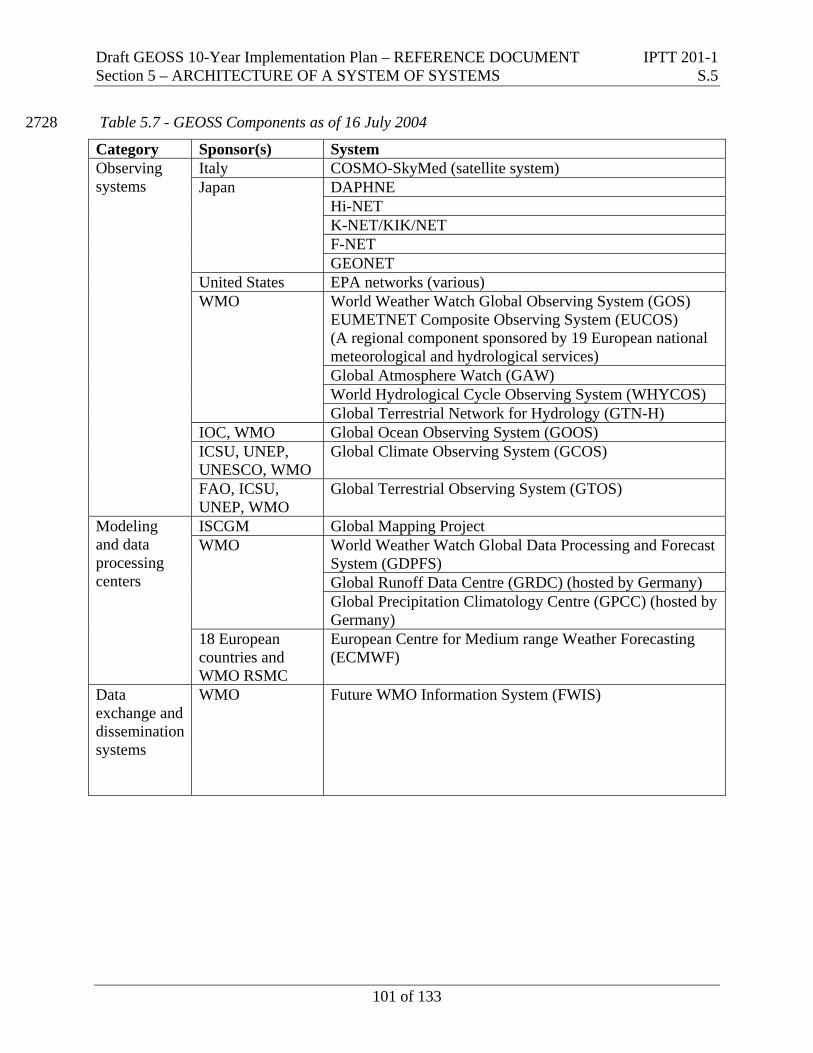
5.7 Initial GEOSS Components
Table 5.7 shows governments and participating organizations that have provided an informal indication to contribute to the initial GEOSS with the noted individual component(s).
100 of 133
Draft GEOSS 10-Year Implementation Plan – REFERENCE DOCUMENT IPTT 201-1 Section 5 – ARCHITECTURE OF A SYSTEM OF SYSTEMS S.5
Table 5.7 - GEOSS Components as of 16 July 2004 2728
Category Sponsor(s) System Italy COSMO-SkyMed (satellite system)
DAPHNE Hi-NET K-NET/KIK/NET F-NET
Japan
GEONET United States EPA networks (various)
World Weather Watch Global Observing System (GOS) EUMETNET Composite Observing System (EUCOS) (A regional component sponsored by 19 European national meteorological and hydrological services) Global Atmosphere Watch (GAW) World Hydrological Cycle Observing System (WHYCOS)
WMO
Global Terrestrial Network for Hydrology (GTN-H) IOC, WMO Global Ocean Observing System (GOOS) ICSU, UNEP, UNESCO, WMO
Global Climate Observing System (GCOS)
Observing systems
FAO, ICSU, UNEP, WMO
Global Terrestrial Observing System (GTOS)
ISCGM Global Mapping Project World Weather Watch Global Data Processing and Forecast System (GDPFS) Global Runoff Data Centre (GRDC) (hosted by Germany)
WMO
Global Precipitation Climatology Centre (GPCC) (hosted by Germany)
Modeling and data processing centers
18 European countries and WMO RSMC
European Centre for Medium range Weather Forecasting (ECMWF)
Data exchange and dissemination systems
WMO Future WMO Information System (FWIS)
101 of 133
Draft GEOSS 10-Year Implementation Plan – REFERENCE DOCUMENT IPTT 201-1 Section 6 – DATA IN THE SERVICE OF USERS S.6
SECTION 6 DATA IN THE SERVICE OF USERS
2729 2730 2731
6 Data In The Service Of Users 2732
2733
2734 2735 2736
2737 2738
2739 2740
2741
2742 2743 2744 2745 2746 2747
2748 2749
2750 2751 2752 2753
2754
6.1 Key Principles
Data sharing is a critical component of GEOSS, without which the societal benefits of Earth observations cannot be achieved. To optimize data sharing, GEOSS participants will need to agree to the following principles:
• GEOSS promotes full and open access to observations, metadata and products, while respecting the different data policies of GEOSS data contributors.
• All such observations and related data should be made available for free or for the cost of reproduction to the research and education communities.
• Data needed for humanitarian purposes should be available free and without restriction.
• GEOSS will encourage access to free metadata, and promote the development and use of flexible, open, and easy to use community standards for metadata. These standards will be interoperable and independent of specific hardware and software platforms. Guidelines for their use will be widely circulated and incorporated into data management training courses. It must be possible to combine seamlessly spatial information from different sources and share it between many users and applications.
• GEOSS will encourage support to appropriate mechanisms for handling intellectual property rights issues.
The following subsections describe several other aspects of data sharing and the overall GEOSS approach in promoting the development of useful information from Earth observations data. These subsections are delineated as: Observations, Products, Dissemination, User Involvement, Research Issues, and Radio Frequency Protection.
6.2 Observations
6.2.1 Collaboration Mechanisms 2755
2756 2757
2758 2759 2760
GEOSS will provide coordination and cost-and-benefit-sharing mechanisms that address several challenges that plague typical international efforts requiring collaboration.
Sampling - Sampling problems emerge wherever Earth system processes operate at scales requiring observations beyond the boundaries of the operating agency, e.g., climate, weather, river basins, migratory species, etc. For instance, an atmospheric carbon dioxide observation
102 of 133
Draft GEOSS 10-Year Implementation Plan – REFERENCE DOCUMENT IPTT 201-1 Section 6 – DATA IN THE SERVICE OF USERS S.6
2761 2762 2763 2764 2765 2766 2767 2768 2769 2770 2771 2772
2773 2774 2775 2776 2777 2778
2779 2780 2781 2782 2783 2784 2785 2786
system is required to satisfy the objectives and protocols of the UN Framework Convention on Climate Change. The observation system must be able to resolve, at the regional scale, net carbon dioxide fluxes into and out of the atmosphere, with sufficient accuracy to verify convention commitments. Given that the atmosphere mixes globally, the accuracy of the example observation system is limited, overall and for particular regions, by the accuracy of the most weakly-sampled region. Thus, adding more samples in the industrialized regions of the northern hemisphere would hardly improve the accuracy there or overall. However, improving the most weakly-sampled region would lead to greater improvements both there, and in all other regions. Clearly, coordination in such situations can minimize the duplication of effort, while also bolstering the credibility and transparency of the sampling program. GEOSS can enhance international coordination of investments in observation systems, observation procedures, and data exchange.
Multi-Use Systems - Another efficiency can be realized by designing Earth observation systems from a multi-use perspective as envisioned in GEOSS. For instance, weather data are necessary inputs to all the societal benefit areas specified in the Framework Document. An optimal observation system for, say, weather forecasting, would not likely be optimal or even sufficient for climate, ecosystems, agriculture or health. But, a mechanism promoting coordination of user requirements can expose opportunities for synergy among users with similar observation needs.
Shared Costs and Benefits - A mechanism for cost and benefit sharing such as GEOSS can often lead to a substantial improvement in an observation network. For instance, the accuracy of weather forecasting models is limited by upper air observations in the southern hemisphere, and particularly over Africa and South America. In the context of many of the developing countries located there, the national benefits of making such observations does not justify the cost, given all the other demands on national resources. Cost sharing can be crucial whenever the principal benefits of a given observation accrue at a scale or location that differs from the jurisdiction of those best placed to make it.
6.2.2 Shared Infrastructure 2787
2788 2789 2790 2791 2792 2793 2794 2795
GEOSS will promote shared infrastructures for Earth observations, leading to cost reductions for participants and providing scientific benefits as well. For example, an oceanographic cruise to sample plankton diversity can simultaneously collect weather data, and a terrestrial network for weather observations can also measure pollution. Similarly, the incremental cost of adding another sensor to a satellite platform with spare capacity is much smaller than building, launching and operating another satellite. In general, sample co-location often yields savings. This is because the costs of single observations are often quite high (especially in remote places), but the incremental costs of taking other observations at the same place are relatively small.
6.2.3 Observation Continuity 2796
2797 2798 2799
GEOSS will address Earth observation continuity, emphasized as a fundamental requirement across the range of societal benefit areas. Continuity is needed for both basic observation networks and intensive observation focused on select areas. Only with assured continuity can
103 of 133
Draft GEOSS 10-Year Implementation Plan – REFERENCE DOCUMENT IPTT 201-1 Section 6 – DATA IN THE SERVICE OF USERS S.6
2800 2801 2802 2803
2804
users invest confidently. The continuity of high- to moderate-resolution optical and SAR observations over land and other critical observations over oceans needs to be assured. Accordingly, contingency plans of observation system operators should be sensitive to how their user communities are affected by interruptions of data and services.
6.3 Products
6.3.1 Common Products 2805
2806 2807 2808 2809 2810
2811 2812 2813 2814
GEOSS will place a high priority on data and information products commonly required across diverse societal benefit areas. Examples of such products include topography, land cover, soil moisture, vegetation, snow cover, wind profile, precipitation, cloud information, water quality, etc. For data with such wide application, it is very important to promote broad convergence on common methods of data classification, representation, calibration and validation.
To understand the interaction of societies with Earth systems, it is critically important to blend socio-economic data with other Earth observation data. Consequently, GEOSS will emphasize promotion of the development and accessibility of socio-economic products, including census data, economic activity, political boundaries, and land ownership records, among many others.
6.3.2 Modeling and Data Assimilation 2815
2816 2817 2818 2819
2820 2821 2822 2823 2824
GEOSS will advocate common methods in the modeling and analysis techniques needed to transform data into useful information. Best practices and up-to-date scientific understanding should be shared broadly. This should include techniques for the estimation and recording of quality indicators, and the representation of uncertainties in models as well as observation data.
In applications such as climate and weather modeling, methodologies known as data assimilation are commonly used. These procedures transform a wide variety of in situ and remotely sensed Earth observations data into parameters that feed into numerical models of physical and chemical processes calculated over time and space. There may be benefit in a targeted effort to enhance sharing across Earth observation areas of operational experience in data assimilation.
6.3.3 Data and Product Quality 2825
2826 2827 2828 2829 2830 2831
GEOSS will advocate that quality assessments be associated with all Earth observations data. It is clear that observations data of known quality from calibrated sensors are essential. For instance, the ability to perform long-term ”traceability” is highly dependent on complete and accurate metadata about precision and accuracy. Calibration must be addressed during product creation and validation is required to ensure the quality of the resulting product. In addition to useful quality descriptions, greater standardization of quality control procedures may be needed.
104 of 133

Draft GEOSS 10-Year Implementation Plan – REFERENCE DOCUMENT IPTT 201-1 Section 6 – DATA IN THE SERVICE OF USERS S.6 6.4 Dissemination 2832
2833 2834 2835 2836 2837 2838 2839 2840 2841
2842 2843 2844 2845 2846 2847 2848 2849
2850
2851 2852 2853 2854 2855 2856
2857
2858 2859 2860 2861
2862 2863 2864 2865 2866 2867 2868
GEOSS will promote data management approaches that encompass a broad perspective of the observations data life cycle, from input through processing, archiving, and dissemination. In some instances, Earth observation systems have met the needs of an immediate user community but lack the documentation or procedural rigor needed for the data to be broadly exchanged with other communities or useful for long-term applications. Data dissemination problems are encountered with restricted and charged data resources as well as with open and free data, and with data archives as well as real-time data sources. Raising the level of data dissemination practice is essential to meet the needs of the many disciplines and varying access requirements of the global Earth observations community.
Improvements in communications management are also important, whether handled as an integral data management function or treated as an outside utility. Earth observation systems utilize many types of communication technologies depending on the particular data, product and timeliness needs of the user. For instance, observation collection systems may involve data exchange among satellites in orbit or floppy disks sent by mail from remote rain forest locations; disaster-warning systems may involve broadcast TV alerts and messages displayed on highways. For many Earth observation applications the medium of choice will be the Internet, but system designers need to think globally when choosing appropriate communications technologies.
6.5 User Involvement
GEOSS will promote the regular involvement of users in reviewing and assessing requirements for Earth observation data, products and services. International organizations, such as FAO, WMO and WHO, are likely to have a key role in connecting users and Earth observation organizations. This may be more challenging in research as distinct from operational institutions. Although GEOSS focuses on global issues, involvement by regional or local regional users is also essential.
6.6 Research Issues
GEOSS will promote more effective transfer into operations of Earth observations technologies that have been proven in the research environment. Research strategic plans should not only address continued investment in the research, but how to turn a successful research system into an operational system.
Because the pace of technological change is rapid, continuous and evolutionary system development is necessary to keep Earth observations systems most effective and efficient. Clearly, the science and practice of Earth observations has a continuing need for improved sensors, sampling strategies, and networks, among many other components. Long-term consistency and sustainability are basic requirements for GEOSS, but new technologies often provide better coverage or precision at lower cost; occasional breakthroughs lead to societal benefits hardly considered possible before.
105 of 133

Draft GEOSS 10-Year Implementation Plan – REFERENCE DOCUMENT IPTT 201-1 Section 6 – DATA IN THE SERVICE OF USERS S.6 6.7 Radio Frequency Protection 2869
2870 2871 2872 2873 2874 2875 2876
2877 2878 2879
2880 2881
2882 2883 2884
2885 2886 2887 2888
2889 2890
2891
2892 2893
2894 2895 2896
2897 2898
In order to enable the various functions that must occur as part of the GEOSS, it is necessary that appropriate frequency allocations exist and are protected. The frequency allocations will be necessary both for telecommunications and for observing systems. In some cases for observations, the required radio frequency will be determined by the physics of atoms and molecules. The full set of GEOSS required radio frequency allocations must take into account national frequency plans as well as those of the International Telecommunication Union (ITU). GEOSS activities should include:
• Review allocations of radio-frequency bands and assignments of radio-frequencies to GEOSS related activities for requirements (telecommunications, instruments, sensors, etc.) and research purposes;
• Coordinate with GEOSS participants to ensure the proper notification and assignment of frequencies, and to determine their future use of the radio spectrum.
• Keep abreast of the activities of the Radio Communication Sector of the International Telecommunication Union (ITU-R), and in particular of the Radio Communication Study Groups;
• Prepare and coordinate proposals and advice to GEOSS participants on radio-regulation matters pertaining to GEOSS activities with a view to ITU Radio Communication Study Groups, Radio Communication Assembly, World Radio Communication Conferences and related regional/global preparatory meetings;
• Facilitate the coordination between GEOSS participants for the use of frequency bands allocated to GEOSS activities with respect to:
• Coordination of frequency use/assignments between countries;
• Coordination of frequency use/assignments between various radio communication services sharing the same band.
• Facilitate the coordination of GEOSS participant with other international organizations which address radio-spectrum planning, including specialized organizations (e.g. CGMS, SFCG) and regional telecommunication organizations (e.g. CEPT, CITEL, APT);
• Assist GEOSS participants, upon request, in the ITU coordination procedure of frequency assignment for radio communication systems sharing a frequency band.
106 of 133