seawifs highlights september 2002 seawifs views development of hurricane isidore these two seawifs...
TRANSCRIPT

SeaWiFS Highlights
September 2002
SeaWiFS Views Development of Hurricane Isidore
These two SeaWiFS images were collected ten days apart. The first was collected on September 18, 2002—before Tropical Storm/ Hurricane Isidore blew through. Part of the cloud field associated with Isidore is visible in the lower right corner of the left-hand frame.
The second image—collected on September 28, 2002—shows a marked increase in the albedo of the coastal waters, particularly in the northern Gulf of Mexico. This is most likely caused by increased wave action associated with the passing storm and increased rain-generated runoff from the land. Both of these processes entrain more suspended sediments in the water column which in turn can make the water reflect a greater percentage of the incoming solar radiation.
The cloud pattern in the lower right corner of the right-hand image is part of Tropical Storm Lili. Lili—reclassified as a hurricane on September 30, 2002—was forecasted to follow a path similar to Isidore's a week before.
POC: 970.2/Gene Feldman

SeaWiFS Views Development of Hurricane Isidore
Sydney
September 18, 2002 September 28, 2002

A Rapidly Shrinking Arctic Perennial Ice Coverfrom Satellite Passive Microwave Data
• From the 1980s to the 1990s, the average area of the perennial ice cover declined by about 10%.
• Sustained decline would lead to its disappearance during this century.
• Reference: Comiso, J. C., A rapidly declining
perennial ice cover in the Arctic, Geophys. Rev. Lett. (2002GL015650, October 2002).

Project Goal: To determine the nature and variability of uncertainties in selected global soil moisture and snow products, measured by the EOS-AQUA AMSR-E sensor on a variety of time scales, and to analyze the effects of these uncertainties on the predictability of the global surface water and energy balance using land surface data assimilation techniques in near real-time.Methodology: 1) Quality check the soil moisture retrieval for all pixels;2) Using Kalman Filters to assimilate soil moisture into one or more land surface models;3) Compare the model output with the original soil moisture retrievals and 4) Investigate the difference to identify any uncertainties in the retrievals.Progresses: 1) Extended Kalman Filter (EKF) installed in Land Data Assimilation System (LDAS);2) The Code is tested with data from the SGP’99 field experiment;3) Daily AMSR-E land products including soil moisture and brightness temperature are being processed in house and will be used in the LDAS-EKF system.
AMSR-E Soil Moisture Product Validation Using Data Assimilation Approach
Xiwu Zhan and Paul R. Houser

AMSR-E Brightness Temperature ofThe 10.7 GHz Band Of North America
Three day composite starting from July 1, 2002
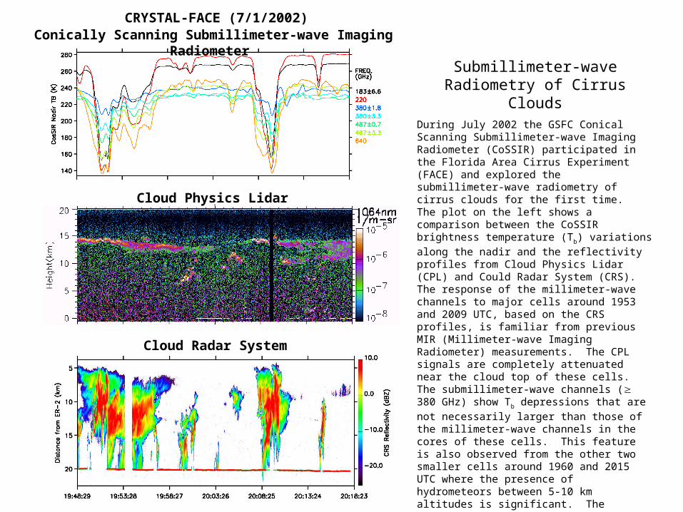
Conically Scanning Submillimeter-wave Imaging Radiometer CRYSTAL-FACE (7/1/2002)
Cloud Physics Lidar
Cloud Radar System
Submillimeter-wave Radiometry of Cirrus Clouds
During July 2002 the GSFC Conical Scanning Submillimeter-wave Imaging Radiometer (CoSSIR) participated in the Florida Area Cirrus Experiment (FACE) and explored the submillimeter-wave radiometry of cirrus clouds for the first time. The plot on the left shows a comparison between the CoSSIR brightness temperature (Tb) variations along the nadir
and the reflectivity profiles from Cloud Physics Lidar (CPL) and Could Radar System (CRS). The response of the millimeter-wave channels to major cells around 1953 and 2009 UTC, based on the CRS profiles, is familiar from previous MIR (Millimeter-wave Imaging Radiometer) measurements. The CPL signals are completely attenuated near the cloud top of these cells. The submillimeter-wave channels ( 380 GHz) show Tb depressions that are not necessarily larger than those
of the millimeter-wave channels in the cores of these cells. This feature is also observed from the other two smaller cells around 1960 and 2015 UTC where the presence of hydrometeors between 5-10 km altitudes is significant. The submillimeter-wave channels dominate the Tb depressions in high cirrus region around 2005
UTC, although O2 and water vapor absorptions
significantly reduce the amplitude of Tb depression for
more opaque channels at 380 and 487 GHz. The 640 GHz channel appears to respond to the thin cirrus between 11-14 km around 2016 UTC, where the millimeter-wave channels ( 220 GHz) show little or no sensitivity.
POC: James R. Wang Tel: (301) 614-5655 Microwave Sensors Branch