seattle design approved commission minutes of … · iain m. robertson anna o’connell nic rossouw...
TRANSCRIPT

APPROVED
MINUTES OF THE MEETING
16 January 2003
Projects Reviewed Convened: 8:30am
Joint Training Facility Charles Street Vactor Storage Building Project Terry Avenue Street Design Terry Avenue Plaza/Schnitzer Development NW Bergen Place Park Southwest Library Expansion Waterfront Planning Effort Monorail Adjourned: 5:00pm Commissioners Present
Jack Mackie, Vice Chair Staff Present Laura Ballock John Rahaim Ralph Cipriani Layne Cubell Cary Moon Brad Gassman Iain M. Robertson Anna O’Connell Nic Rossouw David Spiker Sharon E. Sutton Tory Laughlin Taylor
Seattle Design
Commission
Gregory J. Nickels, Mayor
Donald Royse Chair
Laura Ballock
Ralph Cipriani
Jack Mackie
Cary Moon
Iain M. Robertson
Nic Rossouw
David Spiker
Sharon E. Sutton
Tory Laughlin Taylor
John Rahaim, Executive Director
Layne Cubell, Commission Coordinator
Department of Design, Construction & Land Use
700 5th Avenue, Suite 2000
Seattle, WA 98104-5070 phone 206/233-7911
fax 206/386-4039
printed on recycled paper

Page 2 of 30
SDC 011603.doc 2/19/2003
16 Jan 2003 Project: Joint Training Facility— REVISED Phase: Predesign Previous Reviews: None Presenters: Tony Gale, Fleets and Facilities Martha Turnbull, Fleets and Facilities Joe Chauncey, Boxwood Darrell Turner, Boxwood Attendees: Barbara Goldstein, Seattle Office of Arts and Culture Brian Harris, TCA Architecture and Planning Robin Laughlin, SvR Design Company Brian Mills, Seattle Fire Dept Sue Partridge, Fleets and Facilities Kathy Robertson, SvR Design Company Ken Tiplin, Seattle Fire Dept Time: 1 hour (SDC Ref. # 169 | DC00294)
Action: The Commission thanked the team for coming and for this introduction to an important aspect of the city’s infrastructure, and would like to make the following comments and recommendations.
The Design Commission appreciates the fundamental efforts toward creating a truly sustainable facility, particularly the use of rainwater and stored water to inform the design;
appreciates the team’s early efforts toward addressing the site’s context, including the surrounding areas and neighborhoods, and urges the team to be more active in developing outreach initiatives both on a social and physical level;
recommends the team consider ways to integrate the large expanses of paving into the landscape and topographical design of the project;
suggests the team look at ways to incorporate art into the design in a fundamental and conceptual manner, taking into consideration the nature of the site and the landscape;
would like to see, in the next presentation, a representation and analysis of the surrounding context and an accurate depiction of the site through sections;
recommends the team explore recycled materials applications where possible and consider impervious surfaces; and
recommends approval of the predesign scheme and looks forward to future reviews.
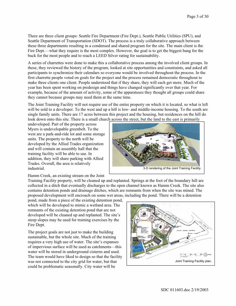
The site for the Joint Training Facility is 12.5 acres in south Seattle, formerly a sand quarry. To the east is SR 509. It is a difficult site with a lot of water and significant slope. The team is looking closely at impacts of their development and is working to keep a light footprint. For the clients’ purposes, the site must have a lot of impervious surface and there are neighborhood concerns regarding this and other aspects of the development.
Context map of the Joint Training Facility.
Page 3 of 30
SDC 011603.doc 2/19/2003
There are three client groups: Seattle Fire Department (Fire Dept.), Seattle Public Utilities (SPU), and Seattle Department of Transportation (SDOT). The process is a truly collaborative approach between these three departments resulting in a condensed and shared program for the site. The main client is the Fire Dept.—what they require is the most complex. However, the goal is to get the biggest bang for the buck for the most people and to reach a LEED Silver rating for sustainability.
A series of charrettes were done to make this a collaborative process among the involved client groups. In these, they reviewed the history of the program, looked at site opportunities and constraints, and asked all participants to synchronize their calendars so everyone would be involved throughout the process. In the first charrette people voted on goals for the project and the process remained democratic throughout to make three clients one client. People understood that if they share, they will each get more. Much of the year has been spent working on predesign and things have changed significantly over that year. For example, because of the amount of activity, some of the apparatuses they thought all groups could share they cannot because groups may need them at the same time.
The Joint Training Facility will not require use of the entire property on which it is located, so what is left will be sold to a developer. To the west and up a hill is low- and middle-income housing. To the south are single family units. There are 17 acres between this project and the housing, but residences on the hill do look down onto this site. There is a small church across the street, but the land to the east is primarily undeveloped. Part of the property across Myers is undevelopable greenbelt. To the west are a park-and-ride lot and some storage units. The property to the north will be developed by the Allied Trades organization and will contain an assembly hall that the training facility will be able to use. In addition, they will share parking with Allied Trades. Overall, the area is relatively industrial.
Hamm Creek, an existing stream on the Joint Training Facility property, will be cleaned up and replanted. Springs at the foot of the boundary hill are collected in a ditch that eventually discharges to the open channel known as Hamm Creek. The site also contains detention ponds and drainage ditches, which are remnants from when the site was mined. The proposed development will encroach on some wet areas, including the pond. There will be a detention pond, made from a piece of the existing detention pond, which will be developed to mimic a wetland area. The remnants of the existing detention pond that are not developed will be cleaned up and replanted. The site’s steep slopes may be used for training exercises by the Fire Dept.
The project goals are not just to make the building sustainable, but the whole site. Much of the training requires a very high use of water. The site’s expanses of impervious surface will be used as catchments—this water will be stored in underground cisterns and used. The team would have liked to design so that the facility was not connected to the city grid for water, but that could be problematic seasonally. City water will be
Joint Training Facility plan.
3-D rendering of the Joint Training Facility.

Page 4 of 30
SDC 011603.doc 2/19/2003
drawn only on an as-needed basis.
As far as structures, the facility program consists of • an emergency vehicle accident prevention driver training area for all three departments; • a six-story drill tower for staging and ladder drills; and • a two-story burn building that is a concrete block structure—inside are burn props used to
practice fire drills.
This facility will be the first in an urban location. Most training facilities use 20–25 acres to accommodate all the necessary elements—at this site they are using 12.5 acres for the same function. In the beginning, the team thought they would need to use more space, but the functional spaces began to overlap.
Key Commissioner Comments and Concerns
Believes that this is an exciting project and would like to know if the fact that the site was formerly a sand quarry presents any seismic challenges.
Proponents stated that that is not the greatest challenge and the high water table presents a bigger challenge. The ground is stable and solid, but the water level fluctuates below the surface, which is one of the reasons the site was moved northward.
Would like to know, because this facility is in an urban area, if the Fire Dept. would have an ongoing blanket exemption on no-burn days so they do not have to stop training.
Proponents stated that because they will use natural gas, it will burn clean and there will be no particulate discharge.
Would like to know if the structure on Spokane St. that the Fire Dept. has will be torn down.
Proponents stated that it will not be because they currently use this building for training and will continue to do so. This building is also on the Historic Register, so it is protected.
Would like to better understand the potential impacts on the neighborhood such as noise, winds blowing odors and smoke, etc. Would like to know if neighborhoods participated in the charrettes along with the client departments. In the conceptual image the perimeter of the site is open and wonders if it will eventually have an enclosure. Would like to know where those being trained can go for assistance should there be an accident.
Proponents stated that there are fire stations in the vicinity that can help if there is an accident. There is established protocol for accidents and a safety officer and ambulance are always presence during training. For something relatively minor, there is a first aid room on site. In addition, there is adequate space on site for a helicopter to land if someone needs to be taken to Harborview.
Proponents stated that there is continual collaboration among the client groups and that the possibility that all departments may want to safely train simultaneously drove the concept design. There was little involvement with the neighborhood in the charrettes because this site will be highly secured with visual and physical exclusion. They may make visible what happens on site through organized tours.
Would like to know then how the team found out about the potential negative impacts in the neighborhoods.

Page 5 of 30
SDC 011603.doc 2/19/2003
Proponents stated that there is the possibility not only of drifting odors, but of light and pollution. They have done traffic and noise studies, which showed that the noise produced on this site will blend with the existing noise level in the Duwamish corridor. The neighbors that are most susceptible to the noise are those on the hill and the team will capitalize on this by providing a buffer.
Proponents stated that the SEPA and MUP process require a process that includes public meetings and the Southwest Fire Station will be used as a model for how to work with the neighborhood. The Department of Neighborhoods will also be involved in the process. The team perceives that one of the big interests will be what happens to Hamm Creek.
Would like to know if the circle drawn around the two-story burn building that overlaps with the road and creek will be setback. Would like to hear about the urban and physical design intentions.
Proponents stated that the staging area for the burn building represented by the circle is not absolute. They got to a point in designing this element where this was the only place it would fit and the Fire Dept. is willing to be flexible and work around it. The team and clients are driven to protecting the creek.
Proponents stated that with regard to urban design, they compressed as many elements as they could and still have safe training. There are areas of intensity and areas of relief. In addition, proponents stated they are trying to incorporate as much green space as possible. Charretting has just begun for the buildings and they hope to do things like have green roofs so the buildings can blend into the hills.
Would like to know, since the green spaces and water is informing site design, how the team decided on the shape of the portion of the stream that will be daylighted.
Proponents stated that it exists in that shape.
Would like to know about the designers’ intentions as they relate buildings and people to this space.
Proponents stated that most people will occupy spaces facing north and east to take advantage of the landscaping area. There may be some interpretive signs that describe how the detention ponds were formed and how the creek was daylighted, etc.
Would like to see, at the team’s next presentation to the Commission, an accurate reflection of the topography to help them understand the site.
Proponents stated that the site is primarily flat in this part because it has been mined. Would like to know if, because of the sand and high groundwater, there is a danger of liquefaction.
Proponents stated that there is no liquefaction.
Believes that with regard to the visual aspect of the site, there is huge flat area with concrete, which will have a big impact. Feels that this is an opportunity for art.
Proponents stated that most of the site people will perceive will be from Myers Way, which is lower than the site. The buffering along Myers Way, the building, and the buffer along the Metro drive is what the vast majority of people will see, not the tarmac.
Feels that perhaps the collapsed building is something an artist can work with.
Proponents stated that it is a premanufactured prop.
Feels that this project is commendable and visible. Acknowledges the amount of work it takes to bring agencies together and without that feels we would see a much higher impact site. Recommends that the team not look at the grade change as a problem, but an opportunity to integrate water systems

Page 6 of 30
SDC 011603.doc 2/19/2003
with the built areas. Does not like the prettification of parking lots with strips of green. If the strips are swales that go to green areas, grade in terms of artistic views and function. Suggests the team work with SvR to make function a part of the art so that functional needs are met through ecologically beneficial methods. Next time, would like to see the larger context including the stream system and neighborhoods.
Commends the team on keeping an open mind on something that has probably become very pro forma.
Key Visitor Comments and Concerns A representative from the Seattle Office of Arts and Culture stated that there are opportunities in this
project for the integration of art and there are three approaches that could be taken, depending on what the partners in the project want:
• on the biggest scale, the work of the facility could be made visible to people and art could be used to help people better understand what is happening here and the sustainability aspects of the site;
• at the next scale down the art could just focus on one aspect of the site like sustainability; and • at the smallest scale, the artist could engage with the architects to incorporate art into the
project.

Page 7 of 30
SDC 011603.doc 2/19/2003
16 Jan 2003 Project: Charles Street Vactor Storage Building Project Phase: Schematic Design Previous Review: None Presenters: Tony Gale, Fleets and Facilities Jay Keiper, Fleets and Facilities Keith Schreiber, Schreiber and Lane Architects Brett Ingham, Schreiber and Lane Architects Attendee: Brian Harris, TCA Architecture and Planning Time: 1 hour (SDC Ref. # 169 | DC00295)
Action: The Commission thanked the team for coming and providing a thorough presentation, and would like to make the following comments and recommendations.
The Design Commission commends the team for working with multiple clients, recognizes the complexity of doing so, and lauds the resolution of that work;
commends the team on the civic responsibility of the project and for looking at the larger context and future development;
supports the proponent’s goal of sustainability and the way in which the building form came about as a result of the functional needs and the reuse of the building footprint;
finds the solution to be an elegant and enticing one that will be an asset to the City;
compliments the team on their presentation document; and clarifies that the project is not in early design, as noted, and recommends
approval of schematic design.
The site for the Vactor Storage Building Project is 10 acres and has been owned by the City for about 30 years. The master plan for the Charles Street Site, if built today, would cost approximately $80 million. Since funding will be appropriated in much smaller amounts, the strategy is to identify individual stand-alone projects rather than phases to match funding as it comes online through the years. Currently, approximately $7 million is appropriated for this particular Charles Street project. Three departments are involved in this project—SPU, Fleets and Facilities, and SDOT. The new development will better facilitate what currently happens on part of the site—primarily storage of crews’ equipment and housing of administrative offices. They have outgrown the existing administrative building and need more space to for fire apparatuses, the paint shop, and the shop to outfit police cars. In addition, many expensive trucks are currently stored outside and are taking up parking (there is no bus service to this site) and are insecure and exposed to the elements. The site now has a two-story structure along Dearborn; the foundation of this structure can handle another story. They are proposing a heavy-vehicle storage garage, development of an administrative building, and a combination of the retail and commercial space at the corner facing the International District. Today, the team is presenting the combination development of the vactor storage at grade, SDOT storage underneath, and Fleets and
Perspective sketch of the Vactor Storage building.

Page 8 of 30
SDC 011603.doc 2/19/2003
Facilities administrative offices above. Building 805 houses vehicle maintenance and is over 50 years old and building 714 they were looking to renovate, but with the budget crunch the funding is gone. The building proponents are presenting today is a condensed version because funding is critical.
The team boiled down what this building needs to address to dirt, trucks, and people and are designing the building to reflect this hierarchy. They also wanted to create something in a human scale that will reflect well to the neighborhood and set a standard. The backdrop of the site is the intersection of two major interstates. Both create noise and I-90 creates a shade zone, which impact the site. The other two edges of the site are 7th, a soft, green edge, and Dearborn. While this project is fairly internally focused, the team is considering future opportunities for expanding the green edge into the site and how to not preclude potential future connections. The surroundings are all one- to two-story buildings and the site slopes down toward Royal Brougham and the corner of Plummer and 7th. The old structure on the part of the site this project is being developed on is a sand bunker. Salt for roads was stored here and has degraded the concrete so this structure is unsafe and needs to come down—this drives the schedule of the project. There will be a lot of early morning activity by this building with trucks moving in and out. Currently, those who dispatch and manage the trucks are not anywhere near what they are directing and trucks’ access to the road is fairly convoluted.
The lowest floor is the “dirt” area and will be almost entirely below grade. The team is reusing the existing foundation and retaining wall of the sand bunker, thus the footprint is set. The bulk of this floor will be for materials storage. There will be four large bins accessible by scoop loaders and a controlled storage area for palettes. The “truck” floor is raised up so it is essentially at grade. It has room for eight vactor trucks. The last bay of this floor provides space for circulation of people. The top floor of the building is the “people” floor. It is an open office space oriented to the north, which maximizes views outward and onto the facility and minimized exposure to the full shade area created by I-90.
Proponents looked for opportunities to achieve the sustainability standards of the City. To this end, the foundation of the sand bunker
is going to be reused and recycled materials such as concrete, steel, and carpet will be employed. It was also important for the building to relate to the human scale at the pedestrian/soft edge, so only the truck and people
Vactor Storage building ground floor plan.
Vactor Storage building first floor plan
Vactor Storage building second floor plan.
Vactor Storage building south elevation. Vactor Storage building section.

Page 9 of 30
SDC 011603.doc 2/19/2003
levels will be visible. The lower two levels will be cast-in-place concrete. The upper level will be lighter with a metal skin that has color and texture variegation. Eventually the site will likely be fenced and they are looking at the undulating brick fence at the substation on 23rd as an example because it has been so well received by the neighborhood. In addition, this kind of fence would help mitigate noise.
Key Commissioner Comments and Concerns
Believes that proponents have gotten further than predesign.
Believes that, in the future to help recover some costs, it might be appropriate in this location to also have some residential space. Recognizes that it’s not appropriate where there are safety concerns so might be more applicable to other buildings to be developed on site. Suggests the team look at a substation in L.A. where the location and views are similar and some space was transformed into residences.
Proponents stated that they are talking with the International District about sharing some parking. The corner of 7th and Dearborn is being considered by the City as potential source of income. This building is more at the internal part of the site, which would be a problem for residential for safety reasons. However, they want to be open to anything around the outside as a possibility.
Feels that one of the most intriguing things about this site is how it works and the interesting interface of people and machines. Would like to know if there is an art budget to perhaps take advantage of this.
Proponents stated that where the trucks go in and out there are few people, mainly just the drivers of the trucks. They would like to add a little green and bring some of the soft edge into the site. There will be vegetation adjacent to the primary pedestrian circulation to provide protection and create softness.
Would like to know if proponents are envisioning visibility between the three layers of the building.
Proponents stated that the three layers do not really interact within the building, but they are trying to design in a way that would not get in the way of future things like that.
Believes that the sand bunker serves as an industrial artifact and would like to know if the team considered preserving it.
Proponents stated that they are going to reuse it—the concrete will be ground up and used. However, the structure itself is falling down and has things like exposed rebar.
Believes this is an elegant solution for a harsh industrial use. In looking at the site plan, would like to know how the vactor trucks will drive in and make such a sharp turn. Would also like to know where office workers will park.
Proponents stated that there is an apron in front that provides enough room for the trucks to turn. Workers will not be walking across where the large trucks are driving when they park—they have a separate parking area.
Feels that it is a lovely surprise for the proponents to reuse what they could and finds it to be an interesting solution at a satisfying scale.
Thanks the team for their good urban context analysis and would like to know if the concrete wall of the existing structure they are keeping will support another story.

Page 10 of 30
SDC 011603.doc 2/19/2003
Proponents stated that they are putting in enough new pilings to take the load. One of the reasons the roof of the larger truck bay is low is because the trucks require a lot of exhaust evacuation, so they need a place to put fans that does not impact the office function. Proponents further stated that they are concerned about noise in the office from the fans and trucks, so the office floor has been isolated and is up on rubber to absorb vibrations from the trucks.
Points out that this project leading the master plan and would like the Commission to keep in mind for the future this analysis and see this as an opportunity to carry it forward other elements of the site. The publication education component of the site was also clearly important to the Commission in their comments from a meeting on the master plan a couple years ago. Feels that is another way to look at the site—how to weave it into the neighborhood.
Recommends that in working on the edge conditions and looking at how to do the wall, the team look and see how different kinds of fences and walls can address different edge conditions. Urges proponents to look at the Harrison St. fence at the Seattle Center as an example.
Page 11 of 30
SDC 011603.doc 2/19/2003
16 Jan 2003 Project: Terry Avenue Street Design Phase: Schematic Design Previous Reviews: 3 October 2002 (Concept Design) Presenters: Lyle Bicknell, CityDesign Tom Berger, Berger Partnership Attendees: Moira Gray, SDOT Michael Jenkins, DCLU Janet Pelz, Pelz Public Affairs Mike Podowski, DCLU Elizabeta Stacishin, Berger Partnership Time: 1 hour (SDC Ref. # 221 | DC00288)
Action: The Commission thanks the team for coming and would like to make the following comments and recommendations.
The Design Commission commends the public and private sector cooperation and is impressed with the team’s follow through in looking at examples in other cities of how to do things better;
recommends approval of the following aspects of the design: • the basic geometries provided in terms of the travel lanes and planting
strip, • the concept of no curbs in places • the proposed use of unit pavers for some pavement surfaces, • the direction the design is moving with respect to types and uses of
pedestrian and street lighting suggests an artist or artists be employed to help in the design details as the
program is implemented in phases; recommends further examination of the relationship between the tree
canopy and the views, particularly at the north end of the avenue; encourages further exploration of the street life and social exchange
opportunities as the city and private sector continue to examine the land use possibilities and potential within this corridor;
encourages recognition of and playing off the uniqueness of the street, especially its location between South Lake Union and downtown;
commends the restraint shown in getting a concept in place, but one that can be responsive to the opportunities that evolve with future development;
encourages the team to develop the design in a way that maintains the industrial character and existing social mix; and
recommends approval of schematic design.
Since the last meeting, the design team has taken a closer look at other cities’ designs of areas with light industrial uses. In Vancouver pedestrian areas are combined with industrials areas like on Granville Island. There are no curbs or major distinctions between street and sidewalk. Oversized industrial-looking canopies provide shelter around some buildings. In Portland’s Pearl District, loading docks have been transformed into patios. Landscaping is informal—without the landscape and furniture, the street would feel abrupt. Unit pavers define the pedestrian area, which will significantly outlast asphalt. In Milwaukee’s Third Ward district brick is used to define pedestrian areas, but it still evokes the industrial

Page 12 of 30
SDC 011603.doc 2/19/2003
character. Details such as pedestrian lighting and bollards also create character and define space.
The portion of Terry Avenue being addressed in this design is from South Lake Union to Denny Way. The street is about 70 feet wide, which is larger than a typical right-of-way. There is significant patchiness of concrete and brick. The problem is how to capture the character and re-present it if the whole street has to be torn up without Disneyfying it? The team is proposing to use different unit pavers to define the functional elements of the right-of-way. The existing brick will be used to define the streetcar alignment and unit pavers will be used for the pedestrian areas. Not much of the brick can be used as is, but the brick that is being taken where buildings are being renovated now can be stored and cleaned and reused. One goal of this project is to not have a universal design take over, but to allow flexibility with development as it comes in.
The general design principles for this project are as follows:
• Urban design elements should be utilitarian/industrial in character rather than ornate.
• Make Terry a pedestrian responsive street that joins and engages adjacent open space.
• Retain historical components wherever possible. If not possible reuse materials inventively.
• The street/plaza furniture and lighting should be pedestrian in scale, and reflect the historical and social character of the South Lake Union Neighborhood.
• Give consideration to surface water harvesting contributing to the Lake Union watershed.
• Vistas of Lake Union should be preserved and enhanced.
The prototypical plan shows that traffic would be two-way, with one lane going in each direction. The southbound lane incorporates the streetcar. Parallel parking would be accommodated at intervals on both sides. A 15–16-foot pedestrian zone on the east side would have informal plantings and room for outdoor café space. This area is flexible to allow for a variety of uses. The east side has a 10-foot sidewalk. There
is a curb along at the northwest along Terry Ave, but the intersection of Harrison and Terry is curbless; bollards are used to separate the pedestrian zone. The east side of the street would be curbless with a swale for water collection.
The team is integrating sustainability aspects into the design, as well. Because of the wider right-of-way, the east side of Terry Ave. will have a 25-foot pedestrian area and as much as 15–16 feet of this could be planted. This could also allow a continuous canopy all the way from South Lake Union Park to Denny Way with both shade trees and understory
Terry Avenue section.
Terry Avenue intersection detail.

Page 13 of 30
SDC 011603.doc 2/19/2003
trees. One the west side of the street there will be trees, but not every 30–40 feet. These will be in traditional vessels and planters. In addition, there will be areas for stormwater cleaning and infiltration. Currently, all of the runoff from this area goes to the Westpoint Treatment facility. With this project, the team hopes to set an environmental precedent and capture 70 percent of the stormwater, clean it, and have it run into Lake Union. Water from the buildings can be piped to the street, along which it will be treated. With a lighting demonstration, the proponents found that low-mount 15-foot inductive pedestrian lights at 40 feet on center achieve a suitable amount of light. In addition, the light created is in the blue-green spectrum, which is better for seeing people and objects, and therefore better for safety.
With lighting, sending runoff to South Lake Union Park, and canopy diversity, this project offers a unique opportunity. Proponents feel that much can be accomplished over a short time because everyone is on board and different stakeholders have been involved early.
Key Commissioner Comments and Concerns
Would like to know if there will be overhead lights for power sources for the trolley and how this would impact the street.
Proponents stated that it works with the light standards; the light standard system and the power source for the streetcar work in conjunction.
Feels that you need to see more overall context to really appreciate this project.
Proponents stated that the impact of changes to Mercer and Valley are not defined enough for them to know what the effect will be yet. The unit pavers at the intersection function uniquely. Westlake will be the main retail and pedestrian street—it will serve as the “Main Street” for this area. Terry is a unique pedestrian zone with a distinct character that is carried over into South Lake Union Park. There are three to four continuous design elements like the interlocking pavers and planting corridor that will be present throughout. A couple of vacated streets provide opportunities to create some open space.
Would like to know how the swales are influencing the character of the street and what kind they will be.
Proponents stated that the swales will clean the water. They will be almost identical to what is happening now, which is a brick runnel. Unit pavers will be used to line water-collecting areas; this water will run into a planting area for cleaning. Stormwater from the buildings will be piped to South Lake Union Park for treatment.
Would like to know what the relationship is between the trees and the views and between Terry Ave. and South Lake Union.
Proponents stated that they want to use an overstory tree along with understory trees. These will impact the width of the view, but will not block it. The trees will actually frame the view on the east side. Between Republican and Mercer, the view corridor can perhaps be widened.
Applauds the team on this project and feels that it is good research with good ideas and a great example of public and private sector collaboration. Recommends having an artist or small or young firm design the planters, lights, and other details to get some edginess. Would like to know the plan for how different parts of this get funded over time.
Proponents stated that there is an LID that would impact Terry Ave. and there is some
Page 14 of 30
SDC 011603.doc 2/19/2003
funding designed for infrastructure that will apply to parts of this. Because this project is a demonstration, there are opportunities in federal funding for water harvesting and lighting. There are also multiple sources for the rest of the project including transportation money, money for the streetcar, development funds, and CIP.
Believes that progress has been made in materials, lighting, etc. Would like to know what kinds of social life the team intends the project to promote.
Proponents stated that they see people relaxing, waiting, eating, meeting, shopping, learning, and so on.
Would like to know how the design supports the above activities.
Proponents stated that the east side gives opportunities for people to gather, for example at sidewalk cafes. They are also relying on the population—the buildings proposed for the area have day populations, however more and more development in South Lake Union will also provide 24-hour occupation. Proponents further stated that they hope the design is flexible enough that it will take on activities of its own as people present them. Retail may make this area a destination and with South Lake Union Park people will walk through the area to get to it.
Would like to know if the team expects even activity throughout or if they are patting areas for more use.
Proponents stated that currently housing is not permitted, but they are hoping to create a pattern that can respond to a number of different land uses. They hope that the zone is defined as it goes, allowing for those different functions.
Advocates for randomness in the paving pattern and feels that one way to make the area successful is to let fate take over.
Believes that proponents have shown a lot of examples of other places. Urges the team to keep in mind that designing for this area is not just designing for Seattle, but very specifically for South Lake Union.
Key Visitor Comments and Concerns A South Lake Union community member stated that she thinks the design holds a lot of potential and
likes the highlighting of the utilitarian/industrial character because it is an area steeped in history. Believes the alley grid is interesting and would like to know if there is any thought to enhancing the alleys to enliven and make them more pedestrian-friendly. The community member further stated that there is a potpourri of different uses and housing types which creates a diversity of people who converge here, also adding character.
Proponents stated that they intend, as in the Pearl District of Portland, to preserve the interesting social mix.

Page 15 of 30
SDC 011603.doc 2/19/2003
16 Jan 2003 Project: Terry Avenue Plaza/Schnitzer Development NW Phase: Alley Vacation Follow-Up Previous Reviews: 7 March 2002 (Alley Vacation), 7 February 2002 (Alley Vacation), 15 February
2001 (Alley Vacation), 7 September 2000 (Alley Vacation Briefing), 19 October 2000 (Briefing)
Presenter: Tom Berger, Berger Partnership Attendees: Lyle Bicknell, CityDesign Sharon Coleman, Vulcan Colleen Dooley, Cascade Neighborhood Council Moira Gray, SDOT Michael Jenkins, DCLU Jack McCullough, McCullough, Hill, Fikso, Kretschmer, Smith Suzi Morris, Schnizter Northwest Trisha Quigley, Schnitzer Northwest Janet Pelz, Pelz Public Affairs Mike Podowski, DCLU Buster Simpson Elizabeta Stacishin, Berger Partnership Time: 0.5 hours (SDC Ref. # 170 | DC00164)
Summary: The Commission appreciates the project update and looks forward to future reviews of design details as they are developed. The Commission would like to know more about the process for artist selection and requests that they have an opportunity to review the RFQ for the artist. They also suggest that proponents contact the Seattle Office for Arts and Cultural Affairs and the King County Arts Commission for their rosters of qualified artists. The Commission asks that the team recognize the importance of Boren as well as Terry in the site design as it progresses. They commend the designer and owner for their responsiveness to the multiple issues that have been raised as part of the alley vacation requirements that have been placed on the project. The Commission requests that, when the proponents return, the full team is present including the architects so they might review the elevations that face onto the plaza.
Proponents’ petition for an alley vacation was approved in September. They are now gathering information for further development. Recently, the team met with a CPED officer to discuss security and they are working on incorporating those ideas. A short list of artists has been created and an RFQ to choose the artist is being developed. An artist will be selected by the end of March. The team would also like to incorporate a school from the area such as Bridgewater or Pilchuk. A meeting at the end of January will provide the community with a forum to share their thoughts and provide ideas. They are working with Vulcan to arrange this open house and do neighborhood outreach. In addition, the team is getting the Seattle Parks and Recreation Dept. involved to help program events.
Key Commissioner Comments and Concerns
Would like to know the process for selecting the artist and how the team came up with the short-listed group.

Page 16 of 30
SDC 011603.doc 2/19/2003
Proponents stated that the people selected for the short list were nominated by Bergen who also got suggestions from the Vulcan artistic director for artist who might suit the project goals. They are looking for someone who has dealt with multiple levels of participation—someone who has previously worked in design teams, in civic circumstances, etc.
Suggests that the team contact Seattle Office for Arts and Cultural Affairs and that King County Arts Commission has a list of public artists, as well.
Would like to know how the question of safety came about.
Proponents stated that as people looked at the design, they saw potential safety hazard spots.
Would like to know if the team is then considering reconfiguration.
Proponents stated that there probably would not be any material reconfiguration.
Feels that the team is focusing on the way the drawing is oriented and urges them not to forget about Boren Ave.
Proponents stated that their point is to take the guidelines from Terry Ave to further design this area.
Commends the designer and owner on their responsiveness to issues raised.
Recommends that next time proponents come in they bring the full team.
Page 17 of 30
SDC 011603.doc 2/19/2003
16 January 2003 Commission Business
ACTION ITEMS A. TIMESHEETS
B. MINUTES FROM 12 DECEMBER AND 19 DECEMBER
2002— APPROVED
DISCUSSION ITEMS C. PUBLIC OUTREACH—CUBELL
D. ANNUAL DEBRIEFING FOLLOW-UP—CUBELL
E. DC RETREAT FOLLOW-UP—CUBELL

Page 18 of 30
SDC 011603.doc 2/19/2003
16 Jan 2003 Project: Bergen Place Park Phase: Design Development
Previous Reviews: 19 September 2002 (Conceptual Design) Presenters: Jeff Benesi, Hewitt Architects Kris Snider, Hewitt Architects Cathy Tuttle, Seattle Parks and Recreation Attendees: Jen Dixon, Artist Katy McNabb, Department of Neighborhoods Michael Shiosaki, Seattle Parks and Recreation Adam Richter, Ballard News-Tribune Dennis Ross Time: 1 hour (SDC Ref. # 169 | DC00287)
Action: The Commission thanks the design team for their responsiveness to comments from the last presentation, and would like to make the following comments and recommendations.
The Commission recognizes the challenges of incorporating different voices and working with a limited budget;
would like proponents to continue to define the park through the site’s geometry and, while the experiential feeling of the site is strong internally, the iconic feeling of the site and its urban design context could be further clarified through the perimeter elements identified for public art;
encourages further exploration of how the conceptual diagram of the five triangles within the main triangle can be integrated and become an expression of the nationalities represented in the neighborhood and serve as significant places in the park;
urges the team to continue to look at subtle grade changes as a way to create comfortable social spaces in the park while maintaining visual connections;
supports the direction in which the design is going and believe it would be hindered by creating additional access from Leary Way;
realizes this is a modest project on a tight schedule and do not need to see the project again, but would like the team to share their drawings when the plan is further along; and
approves design development.
This is a small parks improvement project with a construction budget of less than $200,000. The site is an isolated triangle at the corner of Leary Way, 22nd Ave., and Market St Since the last presentation, the team has gotten artist Jen Dixon on board who they selected through the new artists roster. There is incredible public interest in this project among Ballard residents. The park currently has a mural on the far wall and a lot of stuff in the park, probably in hopes of activating the space. However, it has made it aesthetically too busy and visually confusing. Last time the team presented, the Commission’s message was to:
• understand the uses and users • celebrate symbolism of location • simplify, clarify, define the space • engage the geometry of the site

Page 19 of 30
SDC 011603.doc 2/19/2003
Hewitt Architects and Parks staff also met with the community who said they would like to see the following:
• a living room for Ballard • increased safety through lighting • increased visibility and accessibility • multipurpose space—both active and calm • a Scandinavian connection; the community did not feel a need to keep the existing items (flag
poles, mural, five swans) that try to convey this, but would like some sort of connection • an urban garden—colorful • concessionaires/events accommodations • kinetic sculpture • water
The client’s (Seattle Parks and Recreation) vision for the space included: • no water features • low maintenance, i.e. durable materials • staying on budget—constraints • minimize work in the right-of-way • access from Leary into the corner plaza
The project team sees: • location—powerful but isolated; looking to neighbors to get more eyes on the street • adjacent buildings—lack of integration of the park • grade is an opportunity • Leary Way and the other streets have both positives and negatives • sun, sky opportunities • existing trees are not a positive • cluttered space
Proponents would like to take this space and make a connection to 22nd Ave. and create a gateway into the Ballard historic district, while supporting the neighborhood plan. They propose to make a space that embraces the visitor using landscape to soften and define the space. The community wants the park to have a soft core and the Commission felt that the park needed a strong edge. These could help make the space more understandable. The park will have a clearly defined plan with multiple smaller, more intimate spaces supporting multiple uses.
They are keeping the poles that hold the blue awning at the edge, but removing the awning itself. The artist will create something for the poles the helps define the edge and possibly provides a cultural connection. Pedestrian-scale lighting around the edge of the park will help create a safer space. The team is creating a two-level buffer along Leary Way using shrubs and an elevation change. Along 22nd Ave., the edge will be open so people can freely wander in and out. They are also hoping, for visual access, to pull the edge along 22nd Ave. back and widen the sidewalk, which will allow people to see down the street to the corner of the historic Sunset Hotel. For visual interest at the Market St. edge proponents are hoping to create a window into a glass-blowing studio. Proponents would also like to make a connection to Marvin Gardens across the way. At the tip of the triangle, the team is considering something at grade and another vertical element to provide a terminal piece. With all of these changes, there will be no dark corners in the park.
The park will be furnished with wood benches, the style of which is reminiscent of Danish furniture with soft curves. The outside of the park will be a more urban edge while the interior will be softer and

Page 20 of 30
SDC 011603.doc 2/19/2003
landscaped. The artist is considering how rainwater might creatively be used. The team is hoping to put a concessionaire where the kiosk currently sits. However, they like the kiosk and will relocate it to a more appropriate place on site until a concessionaire is identified.
Key Commissioner Comments and Concerns
Would like to know how the space will work for festivals.
Proponents stated that they generally close the street off for festivals, so the whole area can be a celebration area. The festivities spill out into 22nd Ave.
Would like to know what the paving materials are.
Proponents stated that they are retaining the existing brick along Leary Way and adding another piece along 22nd Ave. to define the pedestrian space.
Would like clarification because the plan shows a continuous row of street trees along 22nd Ave. and the model does not. Feels that the continuous row of trees reinforces the definition of the triangle.
Proponents stated that they have considered having a continuous row of street trees and will continue to explore that idea. They would like to also leave some breathing room because it is a relatively small space.
Points out that the trees are west-facing and would produce a lot of shadow in the park.
Recommends the team look at this intersection in L.A. where there is a line of palm trees that announce the intersection and make it recognizable to all. Suggests that in selecting trees, proponents consider defining the location with trees that contribute to the identity of the space and define the space from a distance.
Feels that the park works well on the human scale with the benches and the screening landscaping. However, believes that at the larger scale, such as for those driving by, the icon at the corner needs to be pushed further. Seems like there are a lot of good details, but the site is lacking punch. People are talking about trees providing this, but feels it does not necessarily need to be trees.
Points out the hospital further down Market St. that has structure and vertical trees (poplars), which make a statement as you drive by, but once you are in you do not see that.
Is concerned that this is a small space and if trees were put in they might overwhelm the microenvironment. Would like to know what the gray triangles in the model represent.
Proponents stated that they do not really know yet, but they think it will be something that is punched up a little—perhaps for a sitting space. In addition, what are shown are just place holders and the end result may not look like that.
Would like to know what the issues with the grading were.
Proponents stated that at first the community felt that plaza was too sunken down and that it would feel like it was in a hole.
Feels that the grade gives the space protection from Leary Way.
Suggests that maybe the vegetative buffers could be mounded, although it might then need to be wider.

Page 21 of 30
SDC 011603.doc 2/19/2003
Proponents stated that the community wants to be able to walk through and see the other side of the park.
Feels that this project is a huge success, especially with such a tricky site. Believes that having a more car-scale icon is still possible with this scheme, as long as the artist is on board with that idea and motivated by it. Feels that, with regard to the seating, the team has created a comfortable social space and has the right idea of materials and tactile qualities. Likes the edge treatment in the park and likes the mysteriousness of the concrete triangles.
Believes that this scheme is moving in the right direction, but the question of the overall geometry is not quite there yet. Recommends that the team look at how to play up the idea of the five nations and in doing so look at the example of the Berlin embassy project. Suggests that the pieces could start to take over more green and become a secondary rather than tertiary part of the system. Likes idea of these elements being low enough to sit on.
Feels that this is a great scheme. Wants the corner pole to become more and different from the rest and suggests perhaps light could be integrated here and have this become an icon.
Recommends that the team not hesitate to raise the platform in back to make the space more intimate. Would like to know if it is in the maintenance budget to take the awning down now. Feels that this could be a community event and opportunity.
Proponents stated that this question has come up, however in order to alter what is there they need a new design. It would increase the cost of the project to do it now because there would then be two separate demolitions.
Believes that there is still some fussiness around the edges that needs to be resolved and getting the kiosk into the right spot is one of those things. Feels that there is still a little clutter.
Proponents stated that the kiosk is a tough issue because it is beautifully made, but difficult to integrate.
Would like to know if the team needs the Commission to comment on having access through the park along Leary Way.
Proponents stated that that would be helpful.
Feels that the site is already cut up enough and another access point would make it worse.
Key Visitor Comments and Concerns A representative from Seattle Parks and Recreation stated that as a festival space, this is for smaller
scale gatherings for small events because there will be a much larger civic space built just to the north.

Page 22 of 30
SDC 011603.doc 2/19/2003
16 Jan 2003 Project: Southwest Library Expansion Phase: Scope Briefing
Previous Review: None Presenters: Rick Sundberg, Olson Sundberg Kundig Allen Architects Attendees: Jess Harris, DCLU Justine Kim, Seattle Public Libraries Olivier Landa, Olson Sundberg Kundig Allen Architects Dennis Ross Matthew Stannard, Olson Sundberg Kundig Allen Architects Time: 1 hour (SDC Ref. # 221 | DC00099)
Action: The Commission thanked the team for coming early in the design process and would like to make the following comments and recommendations.
appreciates the willingness of Libraries to find an innovative approach to parking issues and delivering library services without negatively impacting the neighborhood;
appreciates the modest approach of the preferred scheme with a 2-story addition to the west and the fact that it adds seismic reinforcement to the existing building, but is concerned with the true cost once all considerations are factored in;
points out the difficulty of adding onto an existing building, both programmatically and architecturally, on such a constrained site;
recognizes that one of the main challenges of the project as a renovation is how it connects to the existing building and urges that a clear connection between new and old be expressed;
supports the investigation of how to get more outdoor space for social activity;
would like the review process to proceed as if this were a new building, given that it’s a substantial expansion;
would like to hear the design principles at the next presentation and how the team is approaching joining the new and old structures, if it happens that proponents are not able to keep the old one, wants to understand how its good qualities will be emulated; and
approves predesign.
Note: Commissioner Cipriani recused himself from this discussion.
This library is in the very southwest part of Seattle at the cusp of the West Seattle and Delridge communities at 35th Ave. and Henderson St. The headwaters for Longfellow Creek is four blocks away. Surrounding the library is a multicultural community of one-story houses with pockets of retail and some apartment buildings. Directly across the street are a small retail building, two- to three-story apartments, and a gallery. In front is a small piece of art by Charles Smith. The existing library is tucked into a 20,000 ft2 lot, so it is a congested site. The building has a small entry court, a garden on the south side, and some small pieces of landscape. This project is an addition that will approximately double the size of the library
Page 23 of 30
SDC 011603.doc 2/19/2003
building and has $2.6 million budget. The existing library was built in the late 1950s and early 1960s by Durham, Anderson, and Freed and is a modest steel and brick structure. There are no seismic components to the building. It is a light and airy building with steel columns. The community likes the building’s transparent entry and the openness of the buildings interior. There is nothing threatening about the building. However, the community does not like the poor acoustics and unpleasant fluorescent lighting. For the addition, the community is concerned with dignity and acknowledgement of the importance of libraries; these will play into how the team frames their design principles.
There is currently space for 24 cars to park and with the addition, 41 parking spaces would be needed according to code. There is a loading dock on the 35th Ave. side of the building. The existing library is essentially one big room with the collection. It is about 15,000 ft2 in size and the addition will be 7500 ft2. A multipurpose room will be added and will function so that it can be isolated from the rest of the building to be used for events that take place when the library itself is closed. The team looked at several configurations for the new addition to the library. The least expensive option is to keep the existing building, but with some demolition, and create a two-story addition to its front. In this scenario, existing parking would be retained. In other more expensive schemes, the team tried shifting the buildings around, but it did not lead to much gain in parking space. The most optimal and most expensive scheme entails a new one-story building with underground parking. However, the community was concerned with safety in the parking garage and this option was far outside the budget. The design team does feel that the parking that is there now appears to be defensible, but really is not that safe. Another scheme places a new, separate building to the north. The team also looked at the option of a completely new two-story building with surface parking, as well. The preferred alternative is the most affordable and is relatively close to budget. In this choice, the existing building is left as is and the addition gets the building out to the street edge. The added piece will have a two-story façade, which will also give it presence on the street. The entrance is on the corner with parking adjacent.
Key Commissioner Comments and Concerns
Would like to hear more about the basic disposition of space in the preferred alternative.
Proponents stated that they are taking the collection, which is what needs to be expanded, and having it take up all the original building and a little of the addition. Most of the public things will be moved to the multipurpose room. Book drops and any things that can have glass will be placed on the street edge of the building to activate that space. So, the multipurpose room and display spaces will be along 35th Ave., and these spaces can also be isolated from collections. Back room operations will be upstairs.
Would like to know if this scheme is the only one with parking at the surface.
Proponents stated that it is.
Believes that in other libraries, Seattle Public Libraries has been adamant that all parking required by code is accommodated and the building is only one story.
A representative from Seattle Public Libraries stated that they always try to provide as much parking as possible and that is a priority. However, in this situation, the site is so tight that that creates different problems. In any given project, they try to make the building one story, but sometimes if the site is constrained they have to make exceptions.
Would like to know where the nearest bus stop is and how many people arrive by different modes of transport like cars, buses, walking, etc.

Page 24 of 30
SDC 011603.doc 2/19/2003
Proponents stated that a bus stop is right out front. They are currently doing the study to find out how people get to the site.
Would like to know if a study of the seismic function of the building has been done because believes it will affect the affordability of the scheme.
Proponents stated that the building is definitely loose.
Would like to know what the character of the trees out front is and whether there is a way to maximize the light.
Proponents stated that they are mature deciduous trees, but they do not know what species they are off hand. The building is set back so far that the trees dominate the streetscape. Barbara Swift is going to be the landscape architect on the project.
Feels that it is almost unheard of that the preferred option is the cheapest.
Proponents stated that it is important to have stewardship over public funds and they think they can pull this off. They like the bones of the space and feel they can manipulate it to create a successful outcome.
Believes this project is similar to the Northeast Branch Library. Agrees with keeping the existing building there, but is concerned that with further study the team will find that retrofitting it to make the building stable will increase the cost.
Proponents stated that they will then have to come back to the Commission.
Realizes that the money is for a renovation, but would like to know what will happen if the stability study finds this option not viable. Also feels that this is more substantial than a typical renovation and is more like rebuilding.
Proponents stated that if there is a substantial change they will have to go back to the Board and find out how viable it is.
Would like to know what other parts of the library the team is keeping.
Proponents stated that they do not really know yet. They would like to keep the whole collection piece and the big gable end that reads pretty flat is very nice. Everything might be taken off the front of the existing building and the little area that bumps out with the bathrooms, storage, etc. will be taken out. Proponents further stated that by the time they get everything in the existing building up to code it will be a lot of money anyway.
With the open floor plan and the collection area being essentially one big open room, feels that it is a programmatic challenge to double its size. You cannot just add an extension to one side. The existing library has a pleasant quality, but encourages proponents to try and figure out why that is. Feels that some of the openness now is a product of the fluorescents and that it was probably originally a darker interior space. Believes that putting an addition on one side will change the open, light quality.
Proponents stated that originally there was a large skylight, which they might look into, but agree that is not a total solution.
Feels that cutting of the little bump out part and adding one big space or taking it all away are really the only solutions.
Thinks the preferred solution has potentially—the addition essentially buttresses three sides of the building. Believes that from an economic standpoint maybe the team has done what they can and feels it is a matter of how the new addition works with the palate of the old design.
Page 25 of 30
SDC 011603.doc 2/19/2003
Supports whatever parking the team feels is necessary given the small the site. Suggests the team consider a gathering space at the entry to give the building more of a civic presence on the street.
Supports the team’s direction of making the corner of Henderson St. and 35th Ave. the civic presence and is excited to see what they do there and how it is landscaped. Believes that calling this a renovation is sliding under the line and sees it more as new construction and suggests the team look at it that way to see how that might change the project. Feels that proponents should follow a new building process because so much will change.
Stated that there are three categories of projects—renovation, addition, and new building.
Feels that this does fundamentally change the way the building interacts with the street.
Recommends the team look closely at how the addition will affect the large trees there.
Agrees and recommends the team look at the possibility of them going away.
Would like to know if the team considered an option with an addition to the north of the existing parking because that would help with the solar access problem.
Proponents stated that they did and that puts parking all along the front.
Would like to know what the next choice option is if the preferred alternative doesn’t work.
Proponents stated that they do not know. If it becomes an option to tear the existing building down they could look into one- and one-half story of parking.
Key Visitor Comments and Concerns
A representative from DCLU stated that he is not familiar with the neighborhood and a parking study has not been done yet, so they do not know what kind of parking the library will need. Believes that not adding any parking will not be taken lightly because it is a significant number of spaces.
Would like to know if the team could look at parking on surrounding streets.
A representative from DCLU stated that they will look at that in addition to whether the building is in close proximity to public transit and how people get there. Stated that because this library is in a commercial zone it will be, process-wise, less cumbersome to deal with because a parking waiver is an administrative decision.
A representative of the southwest community stated that parking is a very sensitive issue in West Seattle and recommends the team look at ways to provide the parking rather than mitigating for a lack of it.

Page 26 of 30
SDC 011603.doc 2/19/2003
16 Jan 2003 Project: Waterfront Planning Effort Phase: Staff Briefing Presenters: John Rahaim, CityDesign Dennis Meier, CityDesign Attendees: Scott Dvorak John Eskelin, Dept. of Neighborhoods Steve Pearce, Seattle Dept. of Transportation Time: 0.75 hours (SDC Ref. # 169 | DC00289)
Summary: The Commission thanked the team for coming and always appreciates contributing and dialoguing about plans for the waterfront, and would like to make the following comments and recommendations.
The Commission supports the phasing, schedule, products, and first steps that proponents have outlined;
encourages the team to think about how to get more visionary thinking into the stakeholder public process in the early stages and hopes the team moves toward a consensus and vision in which the public has contributed in the early stages;
encourages the team to think about having an educational component built into the public outreach to help people conceptualize and contribute to the foundational ideas;
recommends that the team produce graphics up front to help give physical definition to the site and show the enormous scale change that Pier 46 represents; and
believes that it is key to get the Port to help in the planning process and listen to the public will.
The key and challenge to the waterfront planning process is to get the decision parts coordinated and keep pace with the Viaduct because upon the design freeze date, they will stop looking at alternatives and analyze these. The goal is to have a broad enough range of options for the EIS to consider because there are aspects of the waterfront plan that go beyond the Viaduct. There are two physical zones—what the City and State actually rebuild and the zones of influence around those. For the process to be successful they need to juggle being strategic about getting things done while accommodating public process.
The first major outcome of planning the process was to come up with an advisory group of stakeholders with policy expertise and technical expertise. The team hopes different interest groups will help develop alternatives the guidelines to help focus that. The Design Commission and Planning Commission’s will have a strategic role in the process and provide oversight. The entire process is divided into three stages. Phase 1 begins the public involvement process. In phase 2, some planning aspects are tackled in an effort to keep the momentum going. For example, they will explore opportunities for connections with the upland areas and how their development influences waterfront activity. In the final stage (2006), specific implementation measures will be proposed and a design program and understanding of real goals for the waterfront will be developed. This stage then leads to the design competition.
Key Commissioner Comments and Concerns
Likes phasing, products, and sequence, but is concerned with designer’s involvement timeframe.

Page 27 of 30
SDC 011603.doc 2/19/2003
Would like to see the smartest design professionals thinking early, alongside the public and stakeholder process.
Believes that all the public outreach needs to also have an educational component. The purpose of participation is to increase awareness and build political support and if the team wants people to think conceptually about the future of the waterfront, there needs to be examples and instruction on how to achieve that.
Feels that it is important to look at scale and context—Terminal 46 just to the north is very large, about 80 acres and then the site comes to a squeeze point. Believes there is a conceptual warp that needs to be addressed and that they need to visually think about and show downtown as a thin wedge.
Page 28 of 30
SDC 011603.doc 2/19/2003
16 Jan 2003 Project: Monorail Phase: Briefing Presenters: Ethan Melone, Seattle Dept. of Transportation Leslie Bain, Urban designer Attendees: Lyle Bicknell, CityDesign Scott Dvorak John Eskelin, Dept. of Neighborhoods Kristian Kofoed, DCLU/CPCR Vince Lyons, DCLU Eileen Norton, Seattle Monorail Project Adam Richter, Ballard News-Tribune Time: 1 hour (SDC Ref. # 219 | DC00231)
Summary: The Commission thanked the team for bringing a lot together and recognizes that they are working with a tight timeframe, a new situation, a huge project, and a “new language,” and would like to make the following comments and recommendations.
The Commission appreciates the team presenting an overall framework and clarity of roles and interrelationships in this process and values their continuing help in seeing opportunities to influence the design;
asks for the team’s help in comprehending how the Commission integrates into this process and wants to get beyond the mechanics to see where to most appropriately weigh-in;
would like to get to the underlying substantive urban design issues and feels that means, in a project of this scale and schedule, that the Commission’s most critical role may be very immediate and with a different working process than usual;
pledges to, most immediately, put together some larger concerns that the Commission would like to see addressed in the EIS;
is very open to reinventing how the Design Commission works given the uniqueness of this situation and would like to integrate with other commissions as appropriate in the interest of time and resources; and
does not want to sacrifice excellence to a time schedule and puts first its obligation to provide the best design advice to the citizens and City Council.
The Executive has articulated goals for its efforts to support implementation of the Seattle Monorail Project, based on the “City Intent” resolution proposed by the Mayor and approved by Council last year, which are to provide timely and reasonable input and decisions and guide the integration of the monorail into the transportation system and urban environment. The City has the regulatory role while the Monorail Project is the customer because the City has experience in how to shape Seattle and will provide leadership in terms of urban design and the environment. The Monorail Implementation Team is a matrix-managed, interdepartmental staff team. The team reports, through the Monorail Program Manager, to a steering committee comprised of the Deputy Mayor and directors of DCLU, Transportation, and Finance. The framework for the organization of the staff team consists of three major groups: urban design and planning, traffic management, and civil and infrastructure. The team leads will be co-located to facilitate cooperative problem solving across these disciplines. The Design Commission and Planning

Page 29 of 30
SDC 011603.doc 2/19/2003
Commission’s role in the process is to advise all involved parties including the Council, Mayor, Monorail Steering Committee, and the Monorail Implementation Team.
In the urban design analysis, several things are being looked examined. • Streetscape issues: aesthetics, character and integration of system into existing fabric • Land use: how can they take advantage of city-shaping opportunities? • Transportation system: parking policies, intermodal issues
The City’s urban design and planning role extends beyond the scope of the monorail project, but it must inform key monorail project decisions at various points during environmental review and project decision making. For example, the urban design must keep pace with the EIS project proposal, which is due April 2.
With regard to the review process, this project comes under the Commission’s jurisdiction because it is in the right-of-way. Parts will be reviewed elsewhere such as special review districts like Pioneer Square where the Pioneer Square Preservation Board will review the project. In addition, some elements will be in mixed-use developments subject to review by neighborhood Design Review Boards. If the Design Commission alone were to review it, it would take up incredible amounts of time and just isn’t possible. CityDesign will propose a new model based on the Light Rail Review Panel, taking into account unique characteristics of the monorail project, and made up of people from both the Planning and Design Commissions.
Key Commissioner Comments and Concerns
Would like to know if the EIS just deals with alignment and not other design issues.
Proponents stated that the design process is started now and will continue. Just alignment and station locations will be in the project proposal.
Stated that the DCLU planning team is involved in developing the scope for the station integration team. It will be a more focused effort than station area planning and they are hoping to include light urban design work.
Feels that there is not enough time for some of the big picture things to happen. Would like to know who will deal with the overarching design issues.
Proponents stated that they feel good about the extent to which that is being dealt with and VIA is focused on that aspect.
Feels that a piece is missing and would like to see something more proactive happening such as parameters or design guidelines.
Proponents stated that in meetings last year the Planning and Design Commissions felt there should be some overriding system image and because this is a continuous element it has potential to be a great piece of civic architecture in and of itself.
Would like to give input for the EIS on February 6.
Feels that the quick timeframe really limits the Commission’s ability to participate and advise.
Feels that there are different ways to conceive of such a large project such as whether it should be obtrusive or fit in. Because of the scale of the monorail, believes this must be obtrusive and we must celebrate the structure as a piece of civic architecture. Feels that the approach for stations should be

Page 30 of 30
SDC 011603.doc 2/19/2003
different than that for the guideway.
Believes that it is imperative since this project is on the fast track and is huge to try and lay out a work program for the Design Commission that focuses on big things that no one else in the city is talking about.