sea level rise projection in indonesia - 9th eas high … · · 2013-01-29results of the study...
TRANSCRIPT

The Makassar Case Study
Ministry of the Environment - Indonesia Regional Environmental Management Center for Sulawesi Maluku dan Papua
Ridwan D. Tamin, MS(R)
Climate Vunerability and Adaptation Optionfor Coastal dan Delta Cities:
Sea Level Rise Projection in INDONESIA
Year The area Inundated (km2)
Sea Level Rise(m)
2010 7,408 0.4
2050 30,120 0.56
2100 90,260 1.1
Source: Susandi, et all. 2008
Sea Level Rises: Certain Regions of the Country Inundated in the Year of 2100
115 Islands
Source : Susandi, et all. 2008
MoE Regional Office for Sumapapua
MakassarSulawesi
Maluku
Papua
North Sumatera : Pulau BatuWest Sumatera : Pulau Sipora, Pulau Bagai Utara, Pulau Bagai Selatan Riau Islands : Pulau Singkep, Pulau Sebangka, Pulau Lingga, Pulau Abang Besar, Pulau Panuba, Pulau Benuwa, Pulau
Tambelan, Pulau PinangseribuBangka Belitung : Pulau Belitung West Kalimantan : Pulau Karimata ; Kalimantan Selatan : Pulau Laut, Pulau SebukuEast Jawa : Pulau Giliraya, Pulau Gili-genteng, Pulau Puteran, Pulau Sapudi, Pulau Raas, Pulau KangeanBali : Pulau Nusa Penida; NTB: Pulau Giligede,Sangeang; NTT: Pulau Solor, Pulau Pantar, Pulau AdonaraSulawesi Selatan : Pulau Selayar, Pulau Tanah Pulau Lampea, Pulau Bonerate, Pulau KaloatoaSoutheast Sulawesi: Pulau Tukang Bes; Sulawesi Tengah: Pulau BanggaiNorth Maluku : Pulau Mangole, Pulau Tubulai, Pulau Obi, Pulau Obilatu, Pulau Damar, Pulau GebeMaluku : Pulau Watubela, Pulau Wetar, Pulau Tanibar, Pulau Babar, Pulau KaiWest Papua : Pulau Rumberpon, Pulau Gag
Pasal 28 G ayat 1 UUD 1945 Every person has the right to pursue happiness, home, and obtain a good and healthy environment and the right to health services"
Pasal 33 ayat 4 UUD 1945 National economy carried out based on economic democracy using the principals of collectiveness, justice efficiency, sustainable, environmentally friendly, self reliance and preserving progress balance and national economic unity.
Basic Principals for the Environment

Constitution of 1945, Law 32/2009, Law 26/2007, Law 32/2004, Law No. 31/2004, Law 27/2007, Law 17/2004 Right on Healthy and Clean Environment &Sustainable Development, Environmental Protection & Management, Spatial Planning, Local Governance, Fisheries, Coastal and Small Island Management, Ratification of Kyoto Protocol
Coastal Protected Area:Law 5/1990, Law 5/1994,
Reg. 26/2008, President Decree 32/90
Coastal Pollution & Degradation Control: . 38/2007,
.27/1999, MoE Decrees: 04/2001, 51/2004, 200/2004, 2001/2004, 12/2006, 3/2007
Coastal Flora-Fauna Preservation & Utilization: Law 7/1999, Law 8/1999, President Decreee 43/1978 & 1/1987 (Cites)
TThhee GGoovveerrnnmmeenntt PPoolliiccyy oonn CCooaassttaall ZZoonnee:: NNaattiioonnaall,, RReeggiioonnaall aanndd LLooccaall
The Local Regulation of Makassar (PERDA) No. 06/2006 Spatial Planning for Makassar
The Spatial Planning for Makassar 2005-2015
The Local Govt. Reg. No. 6 of 2006: Spatial Planning for Makassar (RTRW Kota Makassar).
The Makassar Newport
Center point of Indonesia
Trans Studio
Revitalization of Losari Beach
SLR Impact in Makassar
Submerged land 22.9 ha
Impact on population 5,840 household
Impact on buildings 4,168 buildings
Sea level rise-SLR is expected to rise by 90 cm in 2100 based on the study: IMPACT EVALUATION OF SEA LEVEL RISE ON INDONESIAN COASTAL CITIES, KOBAYASHI, Hideyuki (2004) in Makassar:
KOBAYASHI, Hideyuki (2004)
Sea Level Rise in Indonesia
Average rise inMean Sea Level
(mm/year)Monitoring
StationSource

Sea Level Rise in Indonesia
90
95
100
105
110
115
120
125
130
135
140
1990
1991
1992
1993
1994
1995
1997
1998
1999
2000
2001
150
160
170
180
190
200
210
220
230
84 85 86 87 88 89 90 91 92 93 94 95 96 97 98 99 0
50
60
70
80
90
100
110
1993
1994
1995
1996
1997
1998
1999
2000
2001
MSL Semarang
Tanjung Priok
MSL JeparaSource: Sutisna S., et al., 2002Variation and trend for MSL (Cm) from three permanent monitoring station 1984 s/d 2002. Average rise : 8 mm/year
0
50
100
150
200
250
300
350
400
19961997
19981999
Batam
0
50
100
150
200
250
1991
1992
1993
1994
1995
1996
1997
1998
1999
Biak
100
120
140
160
180
200
220
240
92 93 94 95 96 97 98 99
Kupang
Sea Level Rise in Indonesia
Source: Sutisna S., et al., 2002Variation and trend for MSL (Cm) from three permanent monitoring station 1984 s/d 2002. Average rise : 8 mm/year
Indonesia
A Study Area of Climate Vulnerability and Adaptation Assessment Option for Makassar
Tomini Bay: The Heart of Coral Triangle
Makassar
Tallo River
Makassar : A Word Class Waterfront City
Area Inundated in the Year of 2100
Area Inundated in the Year of 2100
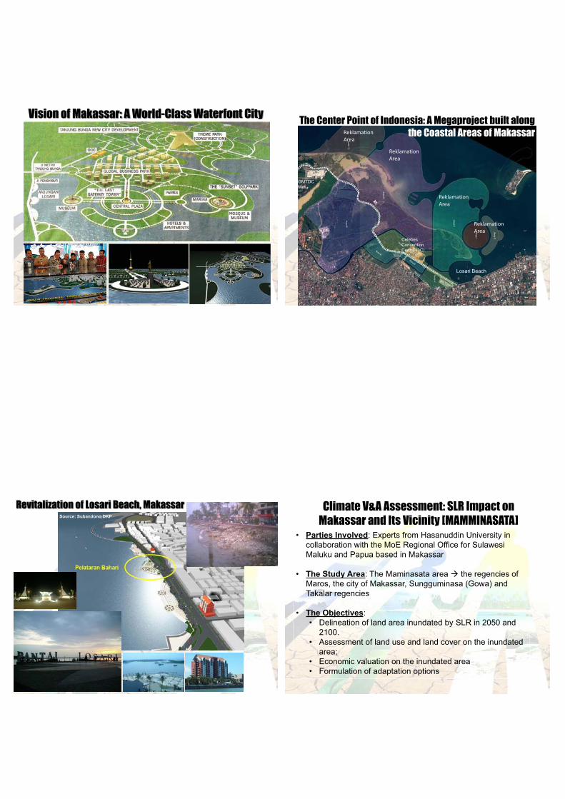
Vision of Makassar: A World-Class Waterfont CityThe Center Point of Indonesia: A Megaproject built along
the Coastal Areas of Makassar
Reklamation Area
Reklamation Area
Reklamation Area
Reklamation Area
Losari Beach
GMTDC Mall
Celebes Convention Centre (3C)
Revitalization of Losari Beach, MakassarSource: Subandono,DKP
Climate V&A Assessment: SLR Impact on Makassar and Its Vicinity [MAMMINASATA]
Parties Involved: Experts from Hasanuddin University in collaboration with the MoE Regional Office for Sulawesi Maluku and Papua based in Makassar
The Study Area: The Maminasata area the regencies of Maros, the city of Makassar, Sungguminasa (Gowa) and Takalar regencies
The Objectives:Delineation of land area inundated by SLR in 2050 and 2100.Assessment of land use and land cover on the inundated area;Economic valuation on the inundated areaFormulation of adaptation options

Results of the Study
Source: Amran Achmad (UNHAS) & PPLH Regional Sumapapua, 2009
Inundated sea water for year 2050 dan 2100 within the Mamminasata area
No. RegencyInundated Area (ha)
Total56 cm 110 cm1. Maros 1.143 933 2.0762. Makassar 908 2.010 2.9183. Gowa 32 202 2334. Takalar 1.131 1.467 2.598
Total 3.214 4612 7.825
Estimated inundated area within Mamminasata by year 2050 & 2100
Makassar Strait
Poatere Port
The Fishermen Village
SLR Impact on Tallo River & its Vicinity, Makassar in the Year of 2050 & 2100Source: Amran Achmad & PPLH Regional Sumpapua KLH, 2009
SLR of 56 cm (2050)
SLR of 110 cm (2100)
Makassar Strait
Poatere Port
The Fishermen Village
SLR Impact on Tallo River & its Vicinity, Makassar in the Year of 2050 & 2100Source: Amran Achmad & PPLH Regional Sumpapua KLH, 2009
SLR Impact on the Fishermen Village, Makassar in the Year of 2050 & 2100
The Fishermen Village
SLR of 56 cm (2050)
SLR of 110 cm (2100)
Makassar Strait
Source: Amran Achmad & PPLH Regional Sumpapua KLH, 2009

SLR Impact on the Area along the Makassar Highway & Its Vicinity in the Year of 2050 & 2100
SLR of 56 cm (2050)
SLR of 110 cm (2100)
Makassar Strait
Source: Amran Achmad & PPLH Regional Sumpapua KLH, 2009
SLR of 56 cm (2050)
SLR of 110 cm(2100)
Makassar Strait
Poatere Port
SLR Impact on Poatere Port & Its Vicinity, Makassar in the Year of 2050 & 2100Source: Amran Achmad & PPLH Regional Sumpapua KLH, 2009
PT Eastern Flour Mill
Pertamina
SLR of 56 cm (2050)
Makassar StraitMassar Port
Pantai Gapura Hotel
Makassar Golden Hotel
Karebossi
SLR Impact on Makassar Port & Its Vicinity, Makassar in the Year of 2050 & 2100Source: Amran Achmad & PPLH Regional Sumpapua KLH, 2009
Makassar Strait
Losari Beach
SLR Impact on Losari Beach, Makassar in the Year of 2050 & 2100Source: Amran Achmad & PPLH Regional Sumpapua KLH, 2009
Makassar Golden Hotel
Imperial Arya Duta Hotel

Makassar Strait
SLR of 56 cm (2050)
SLR of 110 cm (2100)
Trans Studio
Center Point of Indonesia
Celebes Convention Centre (3C)
GMTDC MallAkkarena
BeachTanjung Bunga Housing
SLR Impact on Tanjung Bunga, Makassar in the Year of 2050 & 2100Source: Amran Achmad & PPLH Regional Sumpapua KLH, 2009
Losari Beach
No. Land useMaros Regency Gowa Regency Takalar RegencyArea (ha)
Price (mill Rp.)
Area (ha)
Price (mill Rp.)
Area (ha)
Price (mill Rp.)
1. Settlement 8 520 1 65 177 115.0502. Fish farm 37 20.350 172 94.600 867 476.8503. Rice field - - 91 102.3754, Mixed
catchcrop- 8 6.400 51 4.080
5. Submergedarea
210 115.500 13 7.150 835 459.250
Total 136.370 108.215 1.157.605
Estimated comunity land loss within the Maminasata area due to inundation by 2100
Source: Amran Achmad & PPLH Regional Sumpapua KLH, 2009
Adaptation to Sea Level Rise
Relocate: option chosen if economic and environmental impact are huge, i.e. large floods Makassar with its business centers and infrastructures along the coast would be difficult to relocate..
Accomodate: carried out through reclamation, raising buildings or shifting to aquaculture. Bugis villagers have been developing traditional houses (platform house above land), suitable for adaptation to SLR. Housing developers should be inspired by their traditional technology .
:Protect: hard structure such as breakwater or seawalls and soft structure such as in re-vegetation of mangrove or beach nourishment.
working with nature
Adaptation to Sea Level Rise
Planning: The regional planning process sponsored by the Dept. of Interior (Musrenbang process). Revised spatial plan, designing new coastal protective areas
Public Awareness: Raising awareness on sea level rise and its potential impact, community capacity in dry land agriculture management techniques, community capacity in aquaculture management
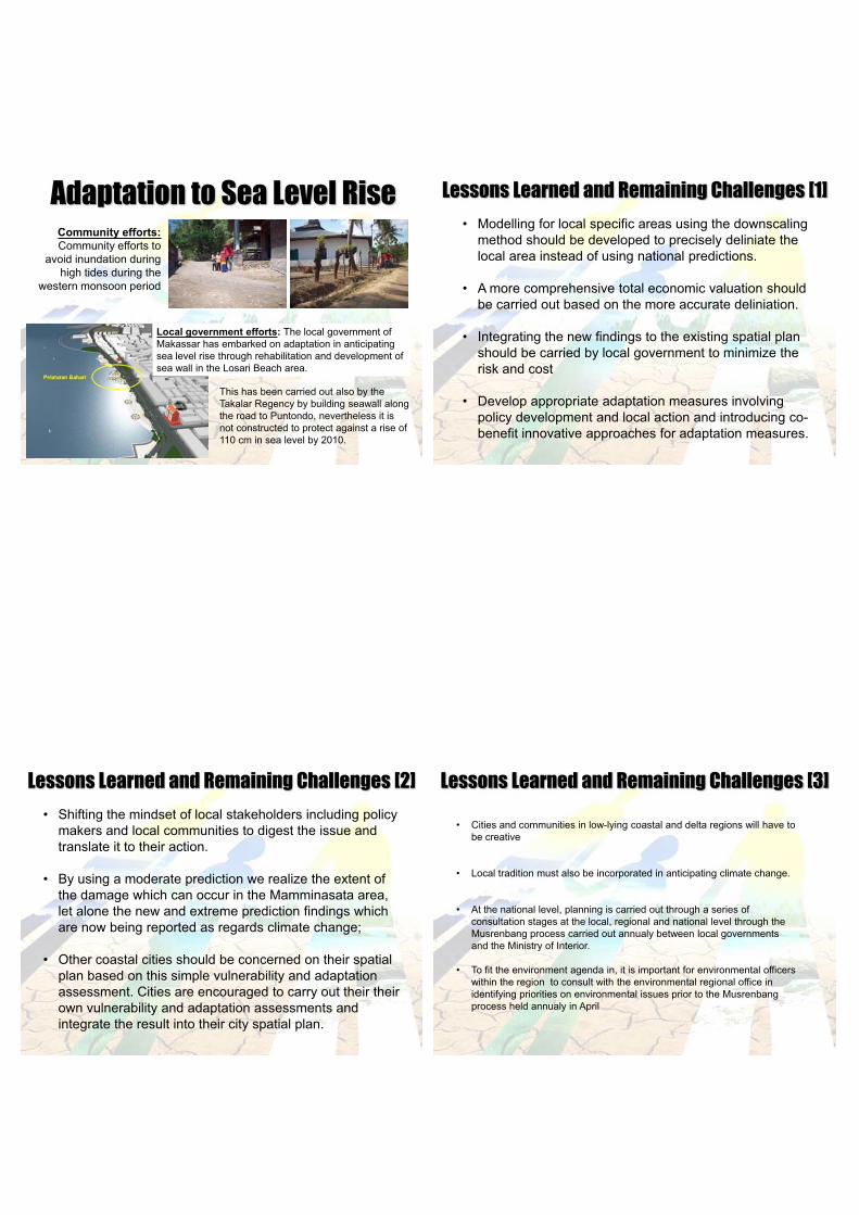
Adaptation to Sea Level RiseCommunity efforts:Community efforts to
avoid inundation during high tides during the
western monsoon period
Local government efforts: The local government of Makassar has embarked on adaptation in anticipating sea level rise through rehabilitation and development of sea wall in the Losari Beach area.
This has been carried out also by the Takalar Regency by building seawall along the road to Puntondo, nevertheless it is not constructed to protect against a rise of 110 cm in sea level by 2010.
Lessons Learned and Remaining Challenges [1]
Modelling for local specific areas using the downscaling method should be developed to precisely deliniate the local area instead of using national predictions.
A more comprehensive total economic valuation should be carried out based on the more accurate deliniation.
Integrating the new findings to the existing spatial plan should be carried by local government to minimize the risk and cost
Develop appropriate adaptation measures involving policy development and local action and introducing co-benefit innovative approaches for adaptation measures.
Shifting the mindset of local stakeholders including policy makers and local communities to digest the issue and translate it to their action.
By using a moderate prediction we realize the extent of the damage which can occur in the Mamminasata area, let alone the new and extreme prediction findings which are now being reported as regards climate change;
Other coastal cities should be concerned on their spatial plan based on this simple vulnerability and adaptation assessment. Cities are encouraged to carry out their their own vulnerability and adaptation assessments and integrate the result into their city spatial plan.
Lessons Learned and Remaining Challenges [2] Lessons Learned and Remaining Challenges [3]
Cities and communities in low-lying coastal and delta regions will have to be creative
Local tradition must also be incorporated in anticipating climate change.
At the national level, planning is carried out through a series of consultation stages at the local, regional and national level through the Musrenbang process carried out annualy between local governments and the Ministry of Interior.
To fit the environment agenda in, it is important for environmental officers within the region to consult with the environmental regional office in identifying priorities on environmental issues prior to the Musrenbang process held annualy in April

Ministry of the Environment - IndonesiaRegional Environmental Management Center
for Sulawesi Maluku and Papua
Jl. P. Kemerdekaan Km. 17 Sudiang Makassar 90243Telp. +62-411-555 701, 555 702, Fax. +62-411-555 703
http://www.menlh.go.id/
Thank You