scwildlands drecp review...
TRANSCRIPT

SC Wildlands Comments on Draft EIR/EIS for DRECP Page 1
SC Wildlands Science & Collaboration for Connected Wildlands
P.O. Box 1052, Fair Oaks, CA 95628 (877) Wildland www.scwildlands.org
Via email only February 23, 2015 California Energy Commission Dockets Office, MS-4, Docket No. 09-RENEW EO-01 1516 Ninth Street Sacramento, CA 95814-5512 [email protected] RE: SC Wildlands’ comments on the Draft EIR/EIS for the DRECP SC Wildlands’ mission is to protect and restore systems of connected wildlands that support native species and the ecosystems upon which they rely. SC Wildlands was engaged by the Alliance for Desert Preservation to review, critique and comment on the DRECP and to make recommendations for improvements to the Reserve Design specifically in the Pinto Lucerne Valley and Eastern Slopes Ecoregion. Comments herein are focused on the Preferred Alternative. Enhancing connectivity and linking natural landscapes has been identified as the single most important adaptation strategy to conserve biodiversity during climate change (Heller and Zavaleta 2009). All of California’s climate adaptation strategies (CNRA 2009, 2014), frameworks (Gov. Brown, CEPA, ARB 2014), and action plans (CDFG 2011; CNRA, CDFA, CEPA 2014) identify maintaining connectivity as one of the most important adaptation strategies to conserve biodiversity and support ecological functions during climate change, with statutory authority and legislative intent found in AB 2785 (2008). Meeting renewable energy production goals is essential to help combat climate change, but the vast scale of Development Focus Areas (DFA) being proposed for renewable energy developments in the California deserts are likely to impact habitat connectivity, alter essential ecosystem functions, and eliminate opportunities for species to shift their ranges in response to climate change. The potential impacts, specifically to wildlife and their ability to move across the landscape, are enormous. Strategically conserving and restoring functional connections between habitat areas is an effective countermeasure to the adverse effects of habitat loss and fragmentation, and it is an essential mitigation measure for climate change. A Linkage Network for the California Deserts (Penrod et al. 2012), commissioned by the Bureau of Land Management and The Wildlands Conservancy, was intended to provide more information to natural resource agencies and the general public concerning where and how to maintain connectivity and sustain ecological functions in a changing climate. The study area encompassed the entire DRECP planning area with a buffer into the neighboring Sierra Nevada and South Coast Ecoregions. The Desert Linkage Network was designed to help meet the following Biological Goals and Objectives of the DRECP “At the landscape-level, the Plan-wide
DOCKETEDCalifornia Energy Commission
FEB 23 2015
TN 74777
09-RENEW EO-1

SC Wildlands Comments on Draft EIR/EIS for DRECP Page 2
BGOs address creating a DRECP-wide, connected, landscape-scale reserve system consisting of large habitat blocks of all constituent natural communities. The reserve system maintains ecological integrity, ecosystem function and biological diversity, maintains natural patterns of genetic diversity, allows adaptation to changing conditions (including activities that are not covered by the Plan), and includes temperature and precipitation gradients, elevation gradients, and a diversity of geological facets to accommodate range contractions and expansions of species adapting to climate change”. The Desert Linkage Network (Penrod et al. 2012) was developed in part based on the habitat and movement requirements of 44 different focal species (Table 1) that are sensitive to habitat loss and fragmentation. These focal species were selected to represent a diversity of ecological interactions and are intended to serve as an umbrella for all native species and ecological processes of interest in the region. These 44 focal species capture a diversity of movement needs and ecological requirements and include area-sensitive species, barrier-sensitive species, less mobile species or corridor-dwellers, habitat specialists, and ecological indicator species. Seven of these focal species are also Covered Species under the DRECP, including Bighorn sheep, Mohave ground squirrel, pallid bat, burrowing owl, Bendire’s thrasher, desert tortoise and Mojave fringe-toed lizard, and 3 of these species (bighorn sheep, desert tortoise and Mohave ground squirrel) were also used as “Reserve Drivers”. In addition to linkages designed for focal species, the Desert Linkage Network (Penrod et al. 2012) was also designed to be robust to climate change. As climate changes the focal species’ distributions and the land cover map is likely to change; indeed it is likely that many land cover types (vegetation communities) will cease to exist as the plant species that define today’s vegetation communities shift their geographic ranges in idiosyncratic ways (Hunter et al. 1988). We used the land facet
Mountain lion Puma concolor
Badger Taxidea taxus
Kit fox Vulpes macrotis
Bighorn sheep Ovis canadensis
Mule deer Odocoileus hemionus
Ringtail Bassariscus astutus
Mojave ground squirrel Spermophilus mohavensis
Round-tailed ground squirrel Spermophilus tereticaudus
Desert pocket mouse Chaetodipus penicillatus
Little pocket mouse Perognathus longimembris
Southern grasshopper mouse Onychomys torridus
Pallid Bat Antrozus pallidus
Burrowing owl Athene cunicularia
Loggerhead shrike Lanius ludovicianus
Cactus wren Campylorhynchus brunneicapillus
Black-tailed gnatcatcher Polioptila melanura
LeConte's thrasher Toxostoma lecontei
Bendire's thrasher Toxostoma bendirei
Crissal thrasher Toxostoma crissale
Greater roadrunner Geococcyx californianus
Desert Tortoise Gopherus agassizii
Chuckwalla Sauromalus obesus obesus
Rosy boa Lichanura trivirgata
Speckled ratt lesnake Crotalus mitchellii
Mojave ratt lesnake Crotalus scutulatus
Mojave fringe-toed lizard Uma scoparia
Collared lizard Crotaphytus bicinctores
Desert spiny lizard Sceloperus magister
Desert night lizard Xantusia vigilis
Red spotted toad Anaxyrus punctatus
Joshua tree Yucca brevifolia
Blackbrush Coleogyne ramosissima
Desert willow Chilopsis linearis
Arrowweed Pluchea sericea
Cat claw acacia Acacia greggii
Mesquite Prosopis glandulosa
Mojave yucca Yucca schidigera
Big galleta grass Pleuraphis rigida
Paperbag bush Salazaria mexicana
Yucca moth Tegeticula synthetica
Desert green hairstreak Callophrys comstocki
Bernardino dotted blue Euphilotes bernardino
Desert ("Sonoran") metalmark Apodemia mejicanus
Ford's swallowtail Papilo indra fordi
Mammals
Birds
Herpetofauna
Plants
Invertebrates
Table 1. Desert Linkage Network Focal Species (Penrod et al. 2012)

SC Wildlands Comments on Draft EIR/EIS for DRECP Page 3
approach (Brost and Beier 2010) to design climate-robust linkages. A land facet linkage consists of a corridor for each land facet, plus a corridor for high diversity of land facets. Each land facet corridor is intended to support occupancy and between-block movement by species associated with that land facet in periods of climate quasi-equilibrium. The high-diversity corridor is intended to support short distance shifts (e.g. from low to high elevation), species turnover, and other ecological processes relying on interaction between species and environments. The focal species linkages and land facet linkages were combined and then refined (e.g., adding riparian connections, removing redundant strands) to delineate the final Desert Linkage Network.
The Desert Linkage Network encompasses 4,229,184 acres. At the time the report was released in 2012, approximately 68% (2,932,291 acres) of the linkage network enjoyed some level of conservation protection (Table 2) mostly in land overseen by the Bureau of Land Management, National Park Service, California State Lands Commission, California Department of Fish and Wildlife, US Fish and Wildlife Service, and The Wildlands Conservancy. An additional 9% (366,394 ac) of the Linkage Network is administered by the Department of Defense, providing some level of conservation for these lands, though not included in DRECP. Thus, the Linkage Network includes substantial (78%) public ownership under the No Action Alternative. We applaud the DRECP for delineating 1,804,000 acres of the Desert Linkage
Network as BLM LUPA Conservation Designations (ACEC, NLCS, or Wildlife Allocation; Table IV.7-71) under the Preferred Alternative, which together with the Existing Conservation Areas and Conservation Planning Areas, would conserve 71% (2,612,000 acres) of Total Available Lands (3,682,000) in the Desert Linkage Network. However, we firmly believe that the other 1,070,000 acres of the Desert Linkage Network is essential to achieving Goal L1: “Create a Plan-wide reserve design consisting of a mosaic of natural communities with habitat linkages that is adaptive to changing conditions and includes temperature and precipitation gradients, elevation gradients, and a diversity of geological facets that provide for movement and gene flow and accommodate range shifts and expansions in response to climate change”. The first page of the Executive Summary uses the word “transparent” to describe the DRECP’s approach but the document is chock full of black box assumptions and analyses that fail to fully and accurately disclose impacts. Section I.3.4.4.3 says, “the reserve design envelope was developed from a systematic and objective approach (Margules and Pressey 2000; Carroll et al.
Table 2. Land Ownership in the Linkage Network (Penrod et al. 2012) Acres Bureau of Land Management 2,663,847 Department of Defense 366,394 National Park Service 109,475 California State Lands Commission 82,517 California Department of Fish and Game 19,664 United States Fish and Wildlife Service 16,322 The Wildlands Conservancy 13,894 California Department of Parks and Recreation 9,943 United States Forest Service 8,801 Special Districts 3,230 Other Federal 2,148 Cities 1,076 Friends of the Desert Mountains 818 Riverside Land Conservancy 313 Counties 242 Private Lands 930,500 Total Desert Linkage Network 4,229,184
SC Wildlands Comments on Draft EIR/EIS for DRECP Page 4
2003; Moilanen et al. 2009) using several independent methods that were iteratively evaluated and refined”. The Evaluation and Refinement is described as “exhaustive interactive GIS comparisons in collaborative mapping sessions,” which isn’t too terribly systematic or objective. This section also says that, “Important areas for desert tortoise, Mohave ground squirrel, and bighorn sheep were based on REAT agency interpretations of the species distribution models and recent occurrence data for these species, which correspond to the BGOs for these species”; also not systematic or objective, especially since most occurrence data is gathered when developments are proposed and thus cover only a portion of these species ranges. This section also says that “quantitative GIS analyses were conducted periodically throughout the evaluation and refinement process to quantitatively track and assess the capture of the species, natural communities, and landscape elements/processes”. In order to fully and accurately disclose impacts, the actual results of those GIS analyses should be in Volume IV rather than after the results have been put through the mysterious acreage calculator. The Impact Analyses and reported acreages are completely nebulous. As described in Section IV.7.1.1, “the reported impact acreage (e.g., acres of impact to natural communities or Covered Species habitat) is based on the overlap of the DFAs and the resource (e.g., mapped natural community or modeled Covered Species habitat) times the proportion of the impacts from Covered Activity development anticipated with the DFA”. The results of the impact analyses are reported in an onerous number of tables with relatively meaningless acreages based on assumptions about proportions of DFAs that will actually be impacted. There are NO maps showing the overlap of the DFA’s and the resource (e.g., mapped natural community or modeled Covered Species habitat). In Volume IV: Environmental Consequences/Effects Analysis, Section IV.07 Biological Resources, there is only ONE Figure, Figure IV.7-1 Subunits, in the entire section. While there is a whopping total of 311 tables associated with this same section, Tables IV.7-1 through IV.7-311. These 311 tables slice and dice the “Conservation Analyses” and “Impact Analyses” in various ways, generally starting with Plan-Wide and then breaking it down by BLM LUPA, NCCP, GCP, Subregions, Covered Species, etc. The various Conservation Analysis tables report actual acreages while the Impact Analysis tables report Total Impact Acres generated by the mysterious black box. For example, the Plan Wide Preferred Alternative includes 2,024,000 acres of DFAs and transmission corridors but says only about 177,000 acres will actually be impacted. Nowhere does the document report actual acreages of how the 2,024,000 acres of DFAs and transmission corridors in the Preferred Alternative overlap for example, habitat for the 37 Covered Species or the Desert Linkage Network. Instead, all of the impact analysis tables associated with the Preferred Alternative relate to the 177,000 acres of reported “Total Impact Acreage”. All tables in Volume IV should add a column to report actual acreage of DFA overlap with resources alongside the reported “Total Impact Acreages”. Maps must be included to show where the DFAs coincide with these resources. And, please do not answer in the Response to Comments that the Data Basin Gateway is serving this purpose; it is an excellent supplemental resource but should not replace basic disclosure of impacts. As currently written, the DRECP approach to impact analysis is anything but transparent. Section I.3.4.4.3 says the Desert Linkage Network was one of several inputs to a focal species, natural communities, and processes approach, which created “an initial reserve design envelope using better information with less uncertainty”. Section I.3.4.4.3 (I.3-26 ) Reserve Design Methods and Appendix D, D.3.6., refers to a composite map of KEY covered species, natural

SC Wildlands Comments on Draft EIR/EIS for DRECP Page 5
communities and processes as “reserve drivers” (i.e., desert tortoise, Mohave ground squirrel, bighorn sheep, microphyll woodland, dunes and sand resources, flat-tailed horned lizard, hydrologic features, and West Mojave corridors, rare natural communities, and environmental gradients), which were selected because they are “important to the overall DRECP conservation strategy and generally occur across a range of ecoregion subareas and habitats of the Plan Area, such that conserving the areas important for the reserve drivers would also conserve areas important for the other Covered Species and natural communities”. There is no figure for this “Composite Map of Key Reserve Drivers” in the document and it is NOT one of the 500+ data layers available for public review on the Data Basin Gateway. While it is clear from ES Figure 5 that landscape connectivity was one of the reserve drivers for many of the conservation designations, Table D-2 in Appendix D Reserve Design Development Process and Methods, indicates that the data generated by Penrod et al. (2012) was only used as a “Reserve Driver” in the Western Mojave, which is ironic because the Western Mojave is particularly hard hit with DFAs that could sever connectivity or significantly reduce functional habitat connectivity. The 37 Covered Species were selected (Appendix B) because they are ALL “important to the overall DRECP conservation strategy. How well do the “Reserve Drivers” (I.3.4.4.3 Reserve Design Methods and Appendix D, D.3.6) capture modeled habitat for all of the “Covered Species”? A quick review of the species distribution models in relation to the Development Focus Areas (DFA) show that several covered species are NOT so well covered by the Key Reserve Drivers (e.g., gila woodpecker, greater sandhill crane, mountain plover, tricolored blackbird, Swainson’s hawk, willow flycatcher, Yuma clapper rail, Alkali mariposa lily). For example, a quick GIS analysis for tricolored blackbird revealed that 60% of its habitat falls within DFAs. Further, another 9% of the tricolored blackbird modeled habitat is Undesignated and available for “disposal (Table 3). This analysis did not even factor in transmission lines. Maps should be included for each of the 37 Covered Species showing their modeled habitat, recorded occurrences and when applicable designated critical habitat in relation to DFAs, FAAs, Table 3. Tricolored blackbird habitat overlap with integrated Preferred Alternative Designation - Preferred Alt Integrated Acres % BLM ACECs 7,910.17 3% BLM ACECs and NLCS 2,243.56 1% BLM Wildlife Allocation 2,694.56 1% Conservation Planning Areas 47,566.51 17% Development Focus Areas 165,526.27 60% Future Assessment Areas 114.79 0% Impervious and Urban Built-up Land 8,361.00 3% Legislatively and Legally Protected Areas 11,525.35 4% Military 6,597.31 2% Military Expansion Mitigation Lands 133.95 0% Open OHV Areas 34.64 0% Tribal Lands 40.09 0% Undesignated 25,125.55 9% Total Modeled Tricolored Blackbird Habitat 277,873.76 100%

SC Wildlands Comments on Draft EIR/EIS for DRECP Page 6
SAAs, and Undesignated land. This is the type of disclosure of impacts this is required under the legal framework provided under 1.2. Currently, the only maps for ALL 37 Covered Species are buried in Appendix C to Appendix Q, Baseline Biology Report. All 37 Covered Species should be Reserve Drivers. Currently, Table IV.7-47 Plan-Wide Impact Analysis for Covered Species Habitat – Preferred Alternative is the closest the Plan gets to disclosing impacts to ALL of the 37 Covered Species. The tricolored blackbird analysis above shows 60% (165,526 acres) of the species habitat falls within DFAs, while Table IV. 7-47 reports only 8,000 acres of Total Impact for this species. There is NO reason why both of these acreages cannot be reported in Table IV.7-47. Table IV.7-57, Plan-Wide Conservation Analysis for Covered Species Habitat – Preferred Alternative is the closest the Plan gets to disclosing how poorly the 37 Covered Species are actually covered by the plan - only 19 of the 37 species have 50% or more or their habitat conserved under the Preferred Alternative. Not even all of the Reserve Drivers are very well “Covered” by the Preferred Alternative. Which begs the question – how well does the reserve design capture the needs of the 123 “Non-Covered” special status species? I.3.4.4.5 DRECP Plan-Wide Reserve Design Envelope for Each Alternative The following standards and criteria were used to develop the Interagency Plan-Wide Conservation Priority Areas (and Conceptual Plan-Wide NCCP Reserve Design):
tant habitat areas that also provide habitat linkages for the movement and interchange of organisms within the Plan Area and to areas outside the Plan Area. o Important habitat linkage areas were included in the NCCP Conceptual Plan-Wide Reserve Design using species-specific linkage information for key Covered Species, including desert tortoise (Gopherus agassizii), Mohave ground squirrel (Xerospermophilus mohavensis), and desert bighorn sheep (Ovis canadensis nelsoni). o Landscape-scale, multispecies habitat linkage information was used to identify movement corridors between habitat blocks inside and outside the Plan Area. o Species-specific threats and stressor information was incorporated to identify the linkage areas critical for inclusion in the NCCP Conceptual Plan-Wide Reserve Design. One of the DRECP Planning Goals in section 1.2 of the Executive Summary is to “Preserve, restore, and enhance natural communities and ecosystems including those that support Covered Species within the Plan Area”. However, it appears that several “fuzzy logic” models of intactness were the primary drivers used to identify the DFAs, regardless of whether the DFAs make up the majority of a given Covered Species habitat. “In order to minimize habitat fragmentation and population isolation, DFAs were sited in less intact and more degraded areas. Based on the terrestrial intactness analysis developed for the DRECP area, approximately 87% of the DFAs in the Preferred Alternative are characterized by low or moderately low intactness. Therefore, a majority of the DFAs are in locations with existing habitat fragmentation and population isolation such that development of Covered Activities in these areas would not appreciably contribute to additional effects”. Yet, habitat loss and fragmentation is precisely why many of the 37 Covered Species and 123 Non-Covered Species are listed as threatened, endangered or sensitive in the first place!

SC Wildlands Comments on Draft EIR/EIS for DRECP Page 7
The California Desert Connectivity Project (Penrod et al. 2012) is briefly described in III.7.7-246. This is the ONLY place in the entire document that refers to “23 crucial linkage planning areas within the Plan Area”. Actually, there were 22 linkage planning areas but nowhere are these crucial linkages actually identified by name. And nowhere are the 22 crucial linkages actually analyzed by linkage. Instead, baseline conditions of the Desert Linkage Network and impacts to the linkage network are analyzed by Ecoregion Subareas, which is relatively meaningless in the context of landscape connectivity since several of the linkages span more than one Ecoregion Subarea. Further, Figures III.7-26 through 7-36 do not label any of the Landscape Blocks intended to be served by the 22 crucial linkages. The discussion in Vol. III Pages 7-248 through 7-271 provides virtually NO information beyond what is already summarized in Tables III.7-69, 7-82, and 7-96 other than vague geographical references, like “providing connectivity between mountain ranges within the ecoregion subarea”. Of particular note, is that none of the targeted Landscape Blocks outside of the Plan Area (e.g., Sierra Nevada, San Gabriel Mountains, San Bernardino Mountains) are labeled or depicted in Figure III.7-26 or in the subareas maps, or in any other maps in the entire document. Yet, several areas of the DRECP refer to the importance of maintaining connectivity beyond the Plan boundary. The DRECP repeatedly refers readers to Penrod et al. 2012 but that document was analyzed and organized by linkage not Ecoregion Subareas, so it is impossible to evaluate and compare baseline conditions or impacts as described in the DRECP to the Desert Linkage Network. The ENTIRE Section, III.7.8 Landscape Habitat Linkages and Wildlife Movement Corridors (III.7 7-245 to 7-248), is VERBATIM to what is provided in Appendix Q on this topic. There is a serious overuse of the Copy/Paste function throughout the document. Typically, an Appendix provides the reader with more relevant information related to the topic being discussed, beyond just the literature cited section. This section of the DRECP alone refers to Appendix Q 23 times! Why not just include the references within the section and consolidate the numerous literature cited sections? The Preferred Alternative estimates a Plan-Wide Total Impact Area for the Desert Linkage Network of 28,000 acres (Table IV. 7-52) based on the overlap of the DFAs with the Desert Linkage Network times the proportion of the impacts from Covered Activity development anticipated with the DFA (IV.7-263). However, based on a GIS analysis of the overlap of the Integrated Preferred Alternative with the Desert Linkage Network, the actual acreage of the DFAs that overlap the Desert Linkage Network is 205,650 acres – which must be disclosed! There is also an additional 198,177 acres in the Linkage Network identified as Undesignated in the Preferred Alternative. Undesignated areas are described in the glossary as BLM-administered lands that do not have an existing or proposed land allocation or designation. These areas would be open to renewable energy applications but would not benefit from the streamlining or CMA certainty of the DFAs. Page II.3-381 under II.3.2.3.4.2 states: “In non-designated lands (i.e. lands not covered by the specific CMAs below), make lands available for disposal through exchange or land sale”. Does this mean that nearly 200,000 acres of the Desert Linkage Network would be “available for disposal”? Shouldn’t this be factored into the “Impact Analysis”? And fully disclosed in the Total Impact Acreage? Additionally, Future Assessment Areas cover 37,377 acres and Special Analysis Areas cover another 29,342 acres of the Desert Linkage Network. Between the DFAs, Undesignated, FAAs and SAAs areas, over 470,547 acres of the Desert Linkage Network could be open to renewable energy applications. There are NO maps that show

SC Wildlands Comments on Draft EIR/EIS for DRECP Page 8
how the DFAs, FAAs, SAAs, Variance Lands, or Undesignated Lands in the Preferred Alternative coincide with the Desert Linkage Network, not to mention transmission corridors! Volume IV is the Environmental Consequences / Affects Analysis yet this section repeatedly refers to maps in Volume III, “Affected Environment Figures III.7-26 through III.7-36 in Chapter III.7 of Volume III shows the desert linkage network for the Plan Area and in each ecoregion subarea”. Maps must be included in Vol. IV for the entire Desert Linkage Network and each of the six subareas that would be impacted. As Figure 1 shows, several linkages are completely severed or severely constrained by DFAs, FAAs and Undesignated land. Undesignated Lands: II.3-9 Table II.3-1 Interagency DRECP Plan-Wide Preferred Alternative identifies 1,323,000 acres of Undesignated lands (i.e., BLM Unallocated Land), 709,000 acres of which is within BLM LUPA (Table II.3-42). This 1.3 million acres of BLM land is NOT clearly depicted in FIGURE II.3-1 Interagency Preferred Alternative but instead appears to be lumped with Impervious and Urban Built-up Land (5,547,000 acres in Table II.3-1), which the legend describes as “Existing Developed Areas”. This is EXTREMELY misleading. These Undesignated lands overlap several areas of high conservation value, including but not limited to habitat for Covered Species, “Reserve Drivers” (e.g., bighorn sheep mountain habitat, bighorn sheep intermountain habitat, desert tortoise intact habitat and fragmented habitat in the Desert Tortoise TCA Habitat Linkages), and numerous areas of the Desert Linkage Network. Further, while much of the Mojave River itself is designated as Conservation Planning Areas in the Preferred Alternative, Undesignated lands or DFAs are located in the uplands along most of the Mojave River. II.3-381 One of the bullets under II.3.2.3.4.2 Conservation and Management Actions states: “In non-designated lands (i.e. lands not covered by the specific CMAs below), make lands available for disposal through exchange or land sale”. Is Undesignated, BLM Unallocated and “non-designated lands” synonymous? Does this mean that over 1.3 million acres of existing public land administered by BLM will be available for “disposal”? Where is the impact analysis regarding these lands? There is no mention of Undesignated, BLM Unallocated, or Non-designated lands in Volume III Environmental Setting/Affected Environment, not in III.13 BLM Lands and Realty - Land Use Authorizations and Land Tenure or III.7 Biological Resources. This is a serious oversight that must be addressed. IV.7-281 is the only place that mentions Undesignated Areas, “Approximately 471,000 acres were not designated as Reserve Design Lands under the Preferred Alternative that were identified in the conceptual reserve envelope, which is primarily comprised of BLM-administered lands in the Plan Area without BLM LUPA conservation designations over them”. What about the other 852,000 acres of Undesignated lands mentioned in Table II.3-1? IV.13 only mentions Undesignated Lands in reference to FAA, SAA, and DRECP Variance lands but Undesignated Lands cover a far greater area than what is included in these designations. Maps must be included in Volumes III and IV that clearly depict ALL Undesignated lands. The entire discussion describing the six different subareas of the Desert Linkage Network that “could be adversely impacted in DFAs and transmission corridors” is inadequate (IV.7-264 and 7-265). Each subarea is allocated one poorly written paragraph that vaguely describes impacts, e.g., “there are DFAs in a portion of the desert linkage network”. Impacts should be analyzed and described in reference to the 22 crucial linkages delineated by Penrod et al. (2012) and further

CALIFORNIA DESERT CONNECTIVITY PROJECTCALIFORNIA DESERT CONNECTIVITY PROJECT
0 30 60Miles
0 25 50 75Kilometers
1:2,138,961Ü
Figure 1. Desert Linkage Network Conflicts
Desert Linkage Network (Penrod et al. 2012)
Previous Linkage Designs (SC Wildlands)
Targeted Wildland Blocks
Preferred Alternative IntegratedDevelopment Focus Areas
Future Assessment Areas
Special Analysis Areas
Undesignated
SC Wildlands Comments on Draft EIR/EIS for DRECP Page 9
evaluated by the focal species and land facet linkage networks, rather than ecoregional subareas. The DRECP should disclose where DFAs completely sever or significantly constrain a linkage, not just provide acreages and describe proportions of subareas. As the lead author in Penrod et al. (2012), I should not have difficulty deciphering the descriptions of impacts to the linkage network. Further, this entire discussion is meaningless without maps that include detailed annotation of all the areas referenced in the text. Lead biologists, Cartographers and Copy Editors should work together to ensure that geographical and locational references in the text are included on the maps (see bold type in following paragraph). Typically, zoomed in maps have more annotation. The maps must clearly and accurately show where DFAs, FAAs, SAAs, Variance Lands and Undesignated lands and Transmission Corridors coincide with the Desert Linkage Network. This is an example of one of the six poorly written paragraphs allocated to discussing Plan-Wide conservation of and impacts to the Desert Linkage Network (IV.7-264), “In the Pinto Lucerne Valley and Eastern Slopes subarea, there are DFAs in a portion of the desert linkage network that connects the Grapevine Canyon Recreation Lands to the Granite Mountains in Lucerne Valley; however, no DFAs are located in the habitat linkage between the Ord Mountains and the Granite Mountains across the Highway 18 east of Apple Valley. There are also DFAs in the linkage that connects Black Mountain to the Mojave River. DFAs under the Preferred Alternative are sited to avoid and minimize impacts to wildlife movement in this subarea by maintaining movement corridors between the San Bernardino Mountains and the Mojave Desert, including in the Ord Mountains to Granite Mountains linkage area and in the Bighorn Mountain area that connects to Johnson Valley and the Morongo Basin. General terrestrial wildlife movement may be affected locally by the development of Covered Activities in these DFAs; however, the siting of DFAs, the reserve design, and the CMAs related to wildlife movement and Covered Species would offset the impacts on general terrestrial wildlife movement”. The linkages in the Desert Linkage Network in the vicinity of the Apple Valley and Lucerne Valley DFAs are the Twentynine Palms Newberry Rodman-San Bernardino Connection and the Twentynine Palms Newberry Rodman-San Gabriel Connection (Penrod et al. 2012), incorrectly described above as “connects Grapevine Canyon Recreation Lands to the Granite Mountains in Lucerne Valley”. These connections connect the San Bernardino and San Gabriel Mountains of the South Coast Ecoregion to the Newberry Rodman Mountains in the Mojave, not Grapevine Canyon to Granite Mountains, which is only a portion of those linkages. Then it says, “No DFAs are located in the habitat linkage between the Ord Mountains and the Granite Mountains” but the DRECP neglects to say that this linkage, which most closely resembles the San Bernardino-Granite Connection (Penrod et al. 2005) is entirely encompassed within the landscape level connection described in the first part of that sentence! Penrod et al. (2005) was a focal species based connectivity assessment and the Desert Linkage Network (Penrod et al. 2012) used improved methods to make the linkages robust to climate change (i.e., land facet analyses). As currently proposed, the Granite Mountain Corridor ACEC is not sufficiently wide to provide live-in and move-through habitat for the target species or support range shifts in response to climate change. Disruption of landscape connections for species movements and range changes is one of the greatest stressors to ecosystems, especially under climate change. In order to achieve Goal L1 - NO DFAs should be sited within the Desert linkage Network, desert tortoise linkages, bighorn

SC Wildlands Comments on Draft EIR/EIS for DRECP Page 10
sheep intermountain habitat and Mohave ground squirrel linkages. All of these species-specific linkages and landscape linkages should automatically be included in the Reserve Design, either as ACEC, NLCS, Conservation Planning Areas, or SAAs. No Undesignated (i.e., BLM Unallocated) land within these linkages should be “disposed of” but should also be automatically included as ACEC, NLCS, SAAs, or Conservation Planning Areas in the Reserve Design.
Objective L1.1: Conserve Covered Species habitat, natural communities, and ecological processes of the Mojave and Sonoran deserts in each ecoregional subarea in the Plan Area in an interconnected DRECP reserve. COMMENT: Must include desert tortoise Ord-Rodman to Joshua Tree and Fremont Kramer Linkages. Objective L1.2: Design landscape linkage corridors to be 3 miles wide where feasible, and at least 1.2 miles wide where a greater width is not feasible. COMMENT: Several landscape linkages designed by Penrod et al. 2012 are greater than 3 miles wide and viable. For instance, it is feasible and desirable to design a linkage more than 1.2 miles wide for the proposed Granite Mountain Wildlife Linkage ACEC with revisions to the Apple Valley and Lucerne Valley DFAs.
Objective L1.3: Protect and maintain the permeability of landscape connections between neighboring mountain ranges to allow passage of resident wildlife by protecting key movement corridors or reducing barriers to movement within intermountain connections, including: o Chuckwalla-Little Chuckwalla-Palen connections o Bristol-Marble-Ship-Old Woman connections o Old Woman-Turtle-Whipple connections o Bullion-Sheephole-Coxcomb connections o Clark-Mesquite-Kingston connections o Big Maria-Little Maria-McCoy connections o Soda-Avawatz-Ord-Funeral connections o Clark-Mesquite-Kingston-Nopah-Funeral connections o Rosa-Vallecitos-Coyote connections o Panamint-Argus connection o Palo Verde-Mule-Little Chuckwalla connections o Palo Verde-Mule-McCoy connections o Chuckwalla-Eagle-Coxcomb connections o Eagle-Granite-Palen-Little Maria connections o Granite-Iron-Old Woman connections o Big Maria-Little Maria-Turtle connections o Northeast slope of the San Bernardino Mountains between Arrastre Creek and Furnace Canyon, including Arctic and Cushenbury canyons, Terrace and Jacoby springs, along Nelson Ridge. COMMENT: Why is this objective restricted to the list of “connections” above? The majority of the mountain ranges listed above are in the Eastern Mojave and Sonoran regions and therefore not consistent with creating a Plan-wide reserve design (Goal L1). These are not the landscape linkages identified in the Desert Linkage Network (Penrod et al. 2012), nor are they the desert tortoise linkages identified in Figure C-34. Where did this list come from? I did not see it referenced in the document.

SC Wildlands Comments on Draft EIR/EIS for DRECP Page 11
Feature Landscape stressors and threats: Goal L3: Reduce, relative to existing conditions, adverse impacts from human activities to natural communities and Covered Species in the Plan Area. Step-Down Biological Objective L3-A: Through the DRECP planning process, establish Development Focus Areas (DFAs) for Covered Activities in locations that would not disrupt or degrade the function of habitat linkages. COMMENT: Figure 1 clearly shows that DFAs would completely sever and disrupt and degrade the function of several linkages. Please see recommended revisions to the Reserve Design for the Pinto Lucerne Eastern Slopes below. I wish I had time to conduct this level of detailed review for the entire Desert Linkage Network! H.2.3 Wildlife Linkages and Connectivity: Figures (H-1 & H-2) depict the wildlife linkages where Covered Activities will be configured to avoid and minimize adverse effects to wildlife connectivity and the function of the wildlife linkage. Figure H-2 Landscape-level Linkage CMA depicts the ENTIRE Desert Linkage Network and SCML Linkages that fall within the DRECP boundary and we wholeheartedly agree that Covered Activities should avoid and minimize impacts to these linkage. Figure H-2 is specifically referenced in the Section II.3.1.2.5.3, Landscape-Level Avoidance and Minimization CMAs, under the CMA AM-LL-1.
AM-LL-1: The siting of projects along the edges of the linkages identified in Appendix H (Figures H-1 and H-2) will be configured (1) to maximize the retention of microphyll woodlands and their constituent natural communities and inclusion of other physical and biological features conducive to species’ dispersal, and (2) informed by existing available information on modeled Covered Species habitat and element occurrence data, mapped delineations of natural communities, and based on available empirical data collected under the MAMP or other sources, including radio telemetry, wildlife tracking sign, and road-kill information. Additionally, Covered Activities will be sited and designed to maintain the function of Covered Species connectivity and their associated habitats in the following linkage and connectivity areas: o Within a 5-mile-wide linkage across Interstate 10 centered on Wiley’s Well Road to connect the Mule and McCoy mountains. o Within a 3-mile-wide linkage across Interstate 10 to connect the Chuckwalla and Palen mountains. o Within a 1.5-mile-wide linkage across Interstate 10 to connect the Chuckwalla Mountains to the Chuckwalla Valley east of Desert Center. o The confluence of Milpitas Wash and Colorado River floodplain within 2 miles of California State Route 78. In addition to these specific landscape linkages identified above, the Riparian and Wetland Natural Communities and Covered Species CMAs will contribute to maintaining and promoting habitat connectivity and wildlife movement (see RIPWET under Section II.3.1.2.5.4). The Covered Species CMAs provide additional avoidance and minimization actions for important species-specific habitat linkages (see Section II.3.1.2.5.4). The DFA configuration of the Preferred Alternative should avoid landscape linkages (Penrod et al. 2012) and species-specific linkages all together in order to minimize impacts to Covered Species under existing habitat conditions and provide ample landscape level connectivity in an uncertain climate. This CMA must be implemented throughout the Desert Linkage Network!
SC Wildlands Comments on Draft EIR/EIS for DRECP Page 12
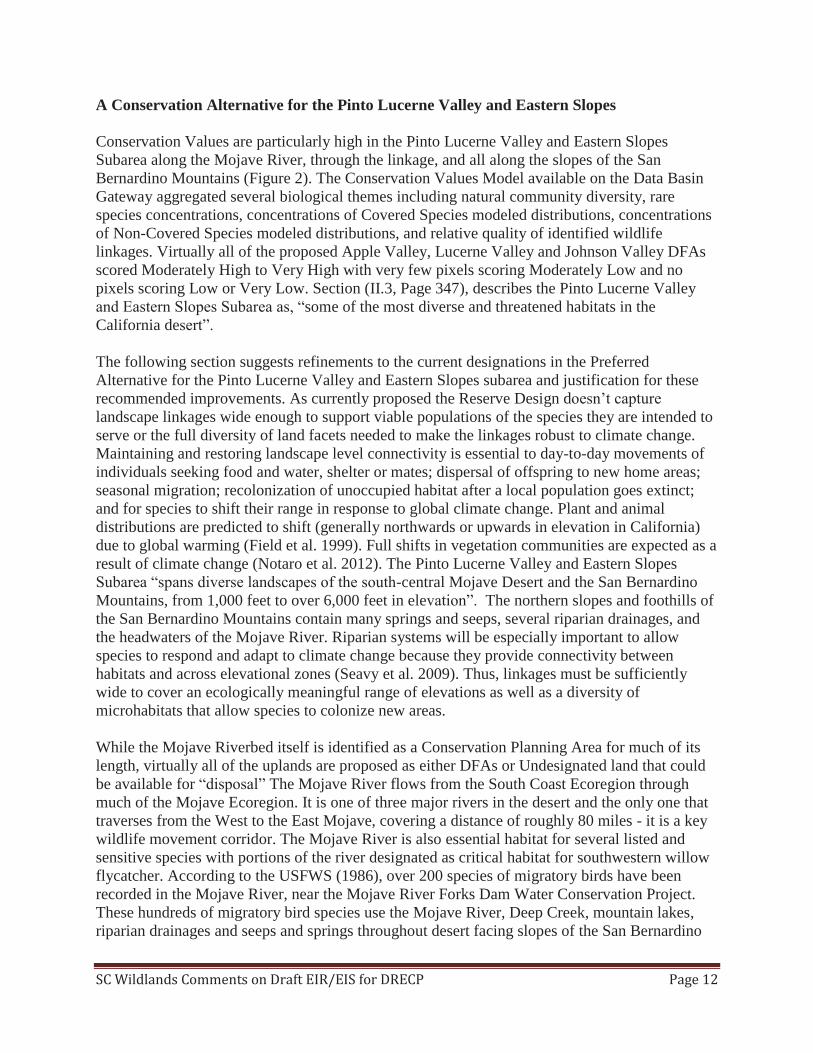
A Conservation Alternative for the Pinto Lucerne Valley and Eastern Slopes Conservation Values are particularly high in the Pinto Lucerne Valley and Eastern Slopes Subarea along the Mojave River, through the linkage, and all along the slopes of the San Bernardino Mountains (Figure 2). The Conservation Values Model available on the Data Basin Gateway aggregated several biological themes including natural community diversity, rare species concentrations, concentrations of Covered Species modeled distributions, concentrations of Non-Covered Species modeled distributions, and relative quality of identified wildlife linkages. Virtually all of the proposed Apple Valley, Lucerne Valley and Johnson Valley DFAs scored Moderately High to Very High with very few pixels scoring Moderately Low and no pixels scoring Low or Very Low. Section (II.3, Page 347), describes the Pinto Lucerne Valley and Eastern Slopes Subarea as, “some of the most diverse and threatened habitats in the California desert”. The following section suggests refinements to the current designations in the Preferred Alternative for the Pinto Lucerne Valley and Eastern Slopes subarea and justification for these recommended improvements. As currently proposed the Reserve Design doesn’t capture landscape linkages wide enough to support viable populations of the species they are intended to serve or the full diversity of land facets needed to make the linkages robust to climate change. Maintaining and restoring landscape level connectivity is essential to day-to-day movements of individuals seeking food and water, shelter or mates; dispersal of offspring to new home areas; seasonal migration; recolonization of unoccupied habitat after a local population goes extinct; and for species to shift their range in response to global climate change. Plant and animal distributions are predicted to shift (generally northwards or upwards in elevation in California) due to global warming (Field et al. 1999). Full shifts in vegetation communities are expected as a result of climate change (Notaro et al. 2012). The Pinto Lucerne Valley and Eastern Slopes Subarea “spans diverse landscapes of the south-central Mojave Desert and the San Bernardino Mountains, from 1,000 feet to over 6,000 feet in elevation”. The northern slopes and foothills of the San Bernardino Mountains contain many springs and seeps, several riparian drainages, and the headwaters of the Mojave River. Riparian systems will be especially important to allow species to respond and adapt to climate change because they provide connectivity between habitats and across elevational zones (Seavy et al. 2009). Thus, linkages must be sufficiently wide to cover an ecologically meaningful range of elevations as well as a diversity of microhabitats that allow species to colonize new areas. While the Mojave Riverbed itself is identified as a Conservation Planning Area for much of its length, virtually all of the uplands are proposed as either DFAs or Undesignated land that could be available for “disposal” The Mojave River flows from the South Coast Ecoregion through much of the Mojave Ecoregion. It is one of three major rivers in the desert and the only one that traverses from the West to the East Mojave, covering a distance of roughly 80 miles - it is a key wildlife movement corridor. The Mojave River is also essential habitat for several listed and sensitive species with portions of the river designated as critical habitat for southwestern willow flycatcher. According to the USFWS (1986), over 200 species of migratory birds have been recorded in the Mojave River, near the Mojave River Forks Dam Water Conservation Project. These hundreds of migratory bird species use the Mojave River, Deep Creek, mountain lakes, riparian drainages and seeps and springs throughout desert facing slopes of the San Bernardino

Bullio
n M
ount
ains
B
¬ «247
01
23
40.
5K
ilom
eter
s
1:30
9,14
4
App
le
Valle
y
Luce
rne
Valle
y
DFA
s G
ener
aliz
edVe
ry H
igh
Hig
hM
oder
atel
y H
igh
Mod
erat
ely
Low
Low
Very
Low
San
Ber
nard
ino
Nat
iona
l For
est
Hyd
rolo
gy
Ord
-Rod
man
DW
MA
Ord
-Rod
man
DW
MA
Sa
n B
ern
ard
ino
S
an
Be
rna
rdin
o
Na
tio
na
l F
ore
st
Na
tio
na
l F
ore
st
John
son
Valle
y
Figu
re 2
. Cos
erva
tion
Valu
es a
re H
igh
in th
e Pi
nto
Luce
rne
Valle
y Ea
ster
n Sl
opes
Eco
regi
on S
ubar
ea

SC Wildlands Comments on Draft EIR/EIS for DRECP Page 13
and San Gabriel Ranges. No DFAs should be sited within the 500 year flood plain and all Undesignated areas along the Mojave River should be included in the Reserve Design to ensure wildlife have access to this essential resource, which will be even more indispensible with climate change. The hydrology of the northern slopes of the San Bernardino Mountains is not just an essential resource for the flora and fauna. It is also extremely important to recharging groundwater basins in Apple, Lucerne and Johnson Valleys. Massive renewable energy projects use enormous amounts of water both in construction and maintenance, which could further exacerbate already severely distressed overdraft conditions in these groundwater basins. As currently proposed the Apple Valley, Lucerne Valley and Johnson Valley DFAs present significant conflicts with habitat and climate change connectivity for Reserve Drivers such as bighorn sheep, desert tortoise, Mojave fringe-toed lizard and the Desert Linkage Network, as well as several other Covered Species, in addition to 31of the 44 focal species addressed by Penrod et al. (2012). There is an approximately 7 mile wide Conservation Planning Area designated between the San Gabriel Mountains and Edwards Air Force Base (AFB), though Military lands are not specifically covered by the DRECP. The essential ecoregional connection between the south-central Mojave Desert and the San Bernardino Mountains (i.e., connectivity to areas outside the plan area) warrants the same consideration, especially since this linkage serves to connect vast areas with conservation designations (e.g., NLCS, ACEC and USFS). It is feasible and desirable to conserve functional landscape-level connectivity here. Here we suggest refinements to the Apple Valley and Lucerne Valley DFAs and complete removal for the Johnson Valley DFA. We created our own Composite Map of Key Reserve Drivers, referred to but not provided in I.3.4.4.3 and Appendix D, D.3.6. The primary data used to create this composite map of Key Reserve Drivers include Desert Tortoise TCA and Linkages (Averill-Murray et al. 2013), Bighorn sheep mountain habitat and intermountain habitat (CDFW 2013), Mohave ground squirrel (Inman et al. 2013, UCSB 2013), and the Desert Linkage Network (Penrod et al. 2012), which were used to make proposed refinements to the Reserve Design (Figure 3). We queried the areas removed from the Apple Valley and Lucerne Valley DFAs and the Johnson Valley DFA using the Site Survey Composite for the Preferred Alternative (i.e., DRECP_Composite_Ecological _Basline_Preferred_Alternative_v5, GIS data downloaded from Data Basin) to identify other Covered Species that would benefit from the proposed changes to the Reserve Design (Table 4). In addition to providing essential habitat for these Reserve Drivers, several other Covered Species will benefit from these refinements including Bendire’s thrasher, burrowing owl, golden eagle, Swainson’s hawk, least Bell’s vireo, southwestern willow flycatcher, yellow-billed cuckoo, tricolored blackbird, mountain plover, pallid bat, Townsend’s big-eared bat, alkali mariposa lily, Little San Bernardino linanthus, Mojave monkeyflower, and Parish’s daisy. These refinements would benefit 18 of the Covered Species. According to the DRECP Composite Ecological Baseline, each pixel in the refinements to the Apple Valley DFA (573 pixels) benefit 4 to 11 Covered Species (MEAN 6.9 species), with a total species count of 3,959 in the 573 pixels. Each pixel in the refinements to the Lucerne Valley DFA (787 pixels) benefit 2 to 10 Covered Species (MEAN 6.45 species), with a total species count of 5,080 in the 787
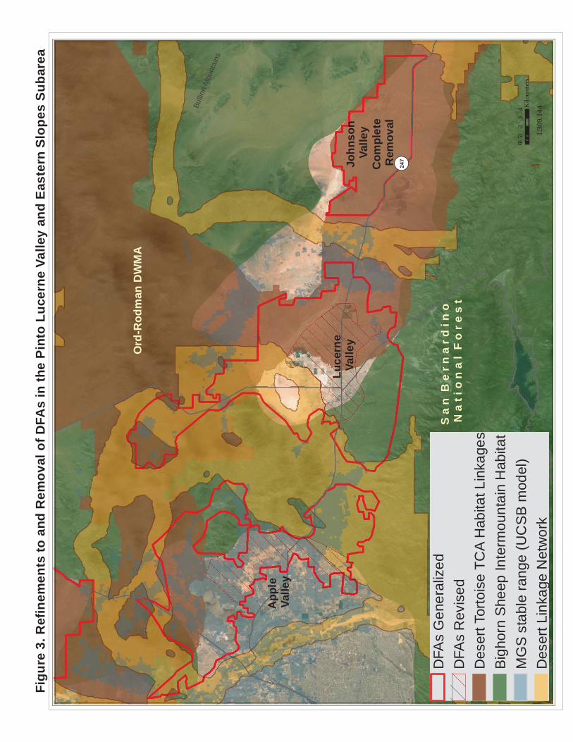
Bullio
n M
ount
ains
B
¬ «247
01
23
40.
5K
ilom
eter
s
1:30
9,14
4
App
le
Valle
y
Luce
rne
Valle
y
DFA
s G
ener
aliz
edD
FAs
Rev
ised
Des
ert T
orto
ise
TCA
Hab
itat L
inka
ges
Big
horn
She
ep In
term
ount
ain
Hab
itat
MG
S s
tabl
e ra
nge
(UC
SB
mod
el)
Des
ert L
inka
ge N
etw
ork
Ord
-Rod
man
DW
MA
S a
n B
e r
n a
r d i
n o
N
a t
i o n
a l
F o
r e
s t
John
son
Valle
yC
ompl
ete
Rem
oval
Figu
re 3
. Ref
inem
ents
to a
nd R
emov
al o
f DFA
s in
the
Pint
o Lu
cern
e Va
lley
and
East
ern
Slop
es S
ubar
ea

SC Wildlands Comments on Draft EIR/EIS for DRECP Page 14
pixels. Each pixel in the Johnson Valley DFA (428 pixels) benefit 4 to 7 Covered Species (MEAN 5.48 species), with a total species count of 2,346 in the 428 pixels. Natural communities in the areas removed from the Apple and Lucerne Valley DFAs and the Johnson Valley DFA are extremely diverse and include but are not limited to, Californian montane conifer forest, Central and South Coastal Californian coastal sage scrub, Great Basin Pinyon /Juniper Woodland, Inter-Mountain Dry Shrubland, Intermontane deep or well-drained
Table 4. Summary of Benefits to Covered Species Using Site Survey Composite for the Preferred Alternative (i.e., DRECP Composite Ecological Basline Preferred Alternative v5, GIS data downloaded from Data Basin).
Covered Species Apple Valley (573 pixels)
Lucerne Valley (787 pixels)
Johnson Valley (428 pixels)
Alkali mariposa lily 0 133 0 Bendire's thrasher 518 564 75 Bighorn sheep 194 139 0 Burrowing owl 559 774 428 desert tortoise 408 719 428 Golden eagle 361 484 353 Least Bell's vireo 80 50 7 Little San Bernardino linanthus 0 84 210 Mohave ground squirrel 253 159 0 Mojave monkeyflower 155 113 0 Mountain plover 7 0 0 Pallid bat 570 756 428 Parish's daisy 108 310 0 Southwestern willow flycatcher 4 7 0 Swainson's hawk 29 0 0 Townsend's big-eared bat 567 775 417 Tricolored blackbird 14 14 0
Yellow-billed cuckoo 3 0 0
Total Species Count in Pixels 3959 5080 2346 # of Covered Species per Pixel 4 to 11 2 to 10 4 to 7
Average # Covered Species per Pixel 6.9 6.45 5.48 soil scrub, Intermontane seral shrubland, California Annual and Perennial Grassland, Lower Bajada and Fan Mojavean /Sonoran desert scrub, Mojave and Great Basin upper bajada and toeslope, Mojavean semi-desert wash scrub, Shadscale/saltbush cool semi-desert scrub, North American Warm Desert Alkaline Scrub, Herb Playa and Wet Flat, Sonoran-Coloradan semi-desert wash woodland/scrub, Madrean Warm Semi-Desert Wash Woodland/Scrub, Mojavean semi-desert wash scrub, North American warm desert dunes and sand flats, North American Warm Desert Alkaline Scrub and Herb Playa and Wet Flat, and, Southwestern North American salt basin and high marsh. In addition, there are several unique plant assemblages in this area due to its location at the juncture of the Mojave and South Coast ecoregions. Here, oak woodlands

SC Wildlands Comments on Draft EIR/EIS for DRECP Page 15
intermingle with Joshua tree and Pinyon-Juniper woodlands amid spectacular rocky outcrops. Ecotones are particularly high in biodiversity and contact zones for evolution. The Twentynine Palms Newberry Rodman-San Gabriel Connection and the Twentynine Palms Newberry Rodman-San Bernardino Connection of the Desert Linkage Network (Penrod et al. 2012) overlap one another in the area of the proposed Apple Valley and Lucerne Valley DFAs. Figure 4 of the Desert Linkage Network in this region also includes the Focal Species Linkage Union (blue) to show the area of the linkage network that was delineated by the land facet analyses (orange). The Proposed Granite Mountain Wildlife Linkage ACEC was designed to connect SBNF with the Bendire’s Thrasher ACEC, while the Northern Lucerne Wildlife Linkage is expected to connect the Bendire’s Thrasher ACEC to Ord-Rodman DWMA. As proposed, the Granite Mountain Wildlife Linkage ACEC is reduced to about 1.2 miles wide for much of its length south of State Route 18 and more closely follows the linkage design for the San Bernardino-Granite Connection (Penrod et al. 2005), which did not include land facet analyses. Several land facets corridors were delineated between these ranges (see Figures 18 and 19 in Penrod et al. 2012), which are expected to support species movements during periods of climate instability. DFAs are proposed to either side of these proposed ACECs that would constrain the linkage for a distance of roughly 20 miles. Species are then expected to make a hard right to follow Stoddard Ridge around the arm of the DFA proposed in the Northern Lucerne Valley. Objective L1.2 is to “Design landscape linkage corridors to be 3 miles wide where feasible, and at least 1.2 miles wide where a greater width is not feasible”. We believe that a greater width is feasible and desirable for the proposed Granite Mountain Wildlife Linkage ACEC. No DFAs should be sited within these areas. The northern arm of the Lucerne Valley DFA bisects both the focal species and land facet linkage and should be reconfigured to avoid the Desert Linkage Network through this area. The FAA should be included as part of the Newberry Rodman ACEC and NLCS due to its high conservation value (e.g., landscape connectivity, bighorn sheep, intact desert tortoise habitat). In fact, 31 of the 44 focal species evaluated by the Desert Linkage Network are expected to be served by this linkage. The westernmost strand of the Desert Linkage Network that follows the Mojave River for a distance and then arcs to the east toward Newberry Rodman is the corridor with high interspersion of land facets which is expected support species movements during periods of climate instability. The northern part of the Apple Valley DFA bisects this part of the linkage between the Mojave River and the Silver Mountains area of a proposed ACEC and should be included in that ACEC and removed from the DFA. Figure 5 depicts Desert Bighorn Sheep - Intermountain & Unfiltered Core Habitat (California Department of Fish and Wildlife, April 2013 Draft, A Conservation Plan for Desert Bighorn Sheep in California) in relation to the Preferred Alternative in this subarea. The Desert Bighorn Sheep Mountain Habitat identifies historic, current, and potential core habitat, while the Intermountain Habitat represents the intermountain, lower slope, valley bottom habitat used by desert bighorn sheep to move between mountain habitat. CDFW, also the lead agency on the NCCP, mapped an intermountain connection between San Bernardino National Forest (SBNF) and Ord-Rodman that has a minimum width of roughly 7.8 miles. Bighorn sheep mountain habitat and intermountain habitat largely overlap with the Desert Linkage Network. The upper arm of the Lucerne Valley DFA disrupts intermountain bighorn habitat and should be

Bullio
n M
ount
ains
B
¬ «247
01
23
40.
5K
ilom
eter
s
1:30
9,14
4
App
le
Valle
y
Luce
rne
Valle
y
Des
ert L
inka
ge N
etw
ork
Foca
l Spe
cies
Lin
kage
Uni
onTa
rget
ed W
ildla
nd B
lock
sD
FAs
Gen
eral
ized
DFA
s R
evis
edH
ydro
logy
Ord
-Rod
man
DW
MA
Ord
-Rod
man
DW
MA
Sa
n B
ern
ard
ino
Na
tio
na
l F
ore
st
Sa
n B
ern
ard
ino
Na
tio
na
l F
ore
st
John
son
Valle
y
Figu
re 4
. Des
ert L
inka
ge N
etw
ork
Con
flict
s in
the
Pint
o Lu
cern
e Va
lley
East
ern
Slop
es E
core
gion
Sub
area
!(
!(!(!(
!(!(!(
!(!(
!(!(!(
!(!(
!(!(
!(!(
!(!(
!(!(!(!(
!(!(
!(!(
!(!(!(!(
!(!(!(
!(!(
!(!(
!(!(
!(!(
!(!(!(!(
!(!(
!(!(!(
!(!(
! (!(
!(!(
!(!(
!(!(
!(!(
!(
!(!(
!(!(
!(!(
!(!(
!(
!(
!(!(!(!(
!(!(!(
!(
!(
!(
!(
!(!(
!(!(
!(
!(!(
Bullio
n M
ount
ains
B
¬ «247
01
23
40.
5K
ilom
eter
s
1:30
9,14
4
App
le
Valle
y
Luce
rne
Valle
y
Big
horn
She
ep M
ount
ain
Hab
itat
Big
horn
She
ep In
term
ount
ain
Hab
itat
Futu
re A
sses
smen
t Are
asO
pen
OH
V A
reas
Und
esig
nate
dD
FAs
Gen
eral
ized
DFA
s R
evis
ed!(
Spr
ings
and
See
ps, D
RE
CP
Hyd
rolo
gy
Ord
-Rod
man
DW
MA
Ord
-Rod
man
DW
MA
Sa
n B
ern
ard
ino
Na
tio
na
l F
ore
st
Sa
n B
ern
ard
ino
Na
tio
na
l F
ore
st
John
son
Valle
y
Figu
re 5
. Big
horn
She
ep C
onfli
cts
in th
e Pi
nto
Luce
rne
Valle
y Ea
ster
n Sl
opes
Eco
regi
on S
ubar
ea

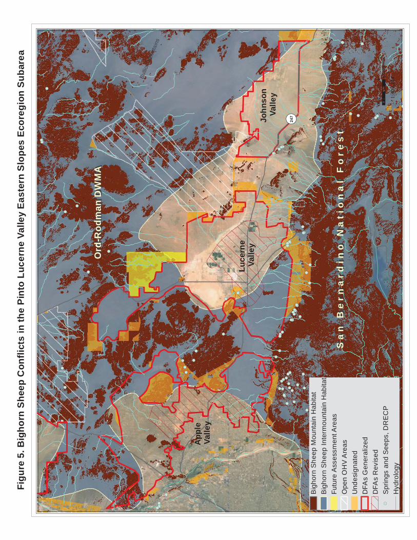
SC Wildlands Comments on Draft EIR/EIS for DRECP Page 16
reconfigured. Further the FAA includes bighorn sheep mountain habitat in close proximity to mountain habitat in the Granite Mountain Linkage and should be included in the Newberry Rodman ACEC and NLCS. Finally, several areas of bighorn sheep mountain habitat are identified as Undesignated and available for “disposal”. Bighorn mountain habitat along the perimeter of the proposed Granite Mountain and Northern Lucerne Wildlife Linkage ACECs should be included in the Reserve Design. Further, Undesignated land on the Ridgeline and slopes of the San Bernardino Mountains between the Juniper Flats NLCS and the Carbonate Endemic Plants NLCS (roughly 15 additional miles is the Grapevine Canyon Recreation Area also known as Juniper Flats by the BLM) should also be included in the Reserve Design, consistent with Step-Down Biological Objective DBSH-B and because there are many springs, seeps, significant riparian canyons, alluvial fans (i.e. rare piedmont fans), and washes in this area essential for bighorn sheep and numerous other species. This area is currently designated as Undesignated in the Preferred Alternative. This land known as the Juniper Flats subregion by the BLM encompasses 101,000 acres on the northern slopes of the San Bernardino Mountains and stretches from the Mojave River to the Cushenbury Grade. The area is continuous with the San Bernardino National Forest, which encompasses over 600,000 acres and boasts over 600 significant cultural sites. There are several unusual and unique plant assemblages here, with oak woodlands intermixed with pinyon-juniper and Joshua trees and spectacular rock outcroppings. The area is extremely close to the Pacific Crest National Scenic Trail and Deep Creek, which has been nominated as a National Wild and Scenic river as part of the Feinstein Bill. The Juniper Flats area has been submitted to the BLM for consideration for NLCS designation and over 25 NGO’s and individuals have endorsed this effort. SC Wildlands strongly supports an NLCS designation for this remarkable area. Goal DBSH1: Conserve the desert bighorn sheep Sonoran–Mojave desert metapopulation) across the DRECP area within well-distributed habitat areas in mountain ranges and intermountain linkages. Emphasize conservation in areas where herds are most likely to be adaptive and resilient in response to the effects of changes within their metapopulations, including, range shifts, contractions, expansions, local extirpation, and recolonization, as well as environmental changes in climate, temperature, and precipitation. Comment: We expect that the Twentynine Palms Newberry Rodman-San Bernardino Connection will be especially important to the Cushenberry Herd of bighorn sheep in a warming climate for access to water resources (e.g., seeps, springs, riparian habitats). Step-Down Biological Objective DBSH-B: Protect, maintain, and manage for the duration of the NCCP on BLM LUPA conservation designation lands and prioritize for conservation on non-BLM lands substantial representative desert bighorn sheep habitat in the following areas: o Newberry, Ord, and Rodman Mountains o North San Bernardino Mountains o El Paso Mountains o Corridors between the North San Bernardino Mountains and Newberry Mountains o Corridors between the San Gorgonio Wilderness Area and the western extremity of the Little San Bernardino Mountains o Portions of the valley habitats between the Palen-McCoy Mountains, Chuckwalla Valley between the Eagle Mountains and the Chuckwalla Mountains
SC Wildlands Comments on Draft EIR/EIS for DRECP Page 17
o Portions of the valley habitats between the Little Chuckwalla Mountains, Palo Verde Mountains, McCoy Mountains, Mule Mountains Comment: The Granite Mountains Wildlife Linkage ACEC as currently proposed is a “corridor” to the south of SR-18 but with our proposed modifications to the DFAs it will be a landscape-level linkage. Conservation and Management Actions for bighorn sheep are pretty slim and the DRECP says, “Within DFAs on BLM-administered lands Desert Bighorn Sheep CMAs would be implemented to the extent feasible and allowable under existing permits, leases, and allotment plans”. Why only to “the extent feasible” rather than to the maximum extent possible? Does this mean CMAs would not be implemented on lands not administered by BLM within the DFAs?
AM-DFA-ICS-34: Access to, and use of, designated water sources will not be affected by Covered Activities in designated and new utility corridors.
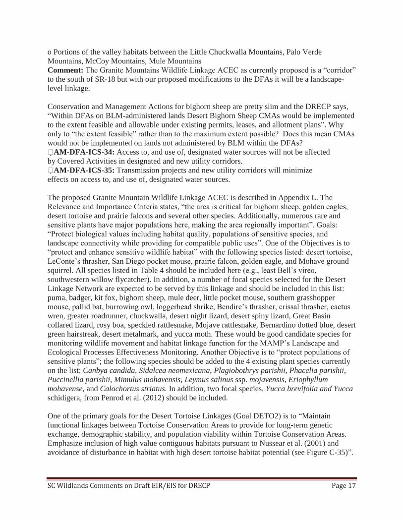
AM-DFA-ICS-35: Transmission projects and new utility corridors will minimize effects on access to, and use of, designated water sources. The proposed Granite Mountain Wildlife Linkage ACEC is described in Appendix L. The Relevance and Importance Criteria states, “the area is critical for bighorn sheep, golden eagles, desert tortoise and prairie falcons and several other species. Additionally, numerous rare and sensitive plants have major populations here, making the area regionally important”. Goals: “Protect biological values including habitat quality, populations of sensitive species, and landscape connectivity while providing for compatible public uses”. One of the Objectives is to “protect and enhance sensitive wildlife habitat” with the following species listed: desert tortoise, LeConte’s thrasher, San Diego pocket mouse, prairie falcon, golden eagle, and Mohave ground squirrel. All species listed in Table 4 should be included here (e.g., least Bell’s vireo, southwestern willow flycatcher). In addition, a number of focal species selected for the Desert Linkage Network are expected to be served by this linkage and should be included in this list: puma, badger, kit fox, bighorn sheep, mule deer, little pocket mouse, southern grasshopper mouse, pallid bat, burrowing owl, loggerhead shrike, Bendire’s thrasher, crissal thrasher, cactus wren, greater roadrunner, chuckwalla, desert night lizard, desert spiny lizard, Great Basin collared lizard, rosy boa, speckled rattlesnake, Mojave rattlesnake, Bernardino dotted blue, desert green hairstreak, desert metalmark, and yucca moth. These would be good candidate species for monitoring wildlife movement and habitat linkage function for the MAMP’s Landscape and Ecological Processes Effectiveness Monitoring. Another Objective is to “protect populations of sensitive plants”; the following species should be added to the 4 existing plant species currently on the list: Canbya candida, Sidalcea neomexicana, Plagiobothrys parishii, Phacelia parishii, Puccinellia parishii, Mimulus mohavensis, Leymus salinus ssp. mojavensis, Eriophyllum mohavense, and Calochortus striatus. In addition, two focal species, Yucca brevifolia and Yucca schidigera, from Penrod et al. (2012) should be included. One of the primary goals for the Desert Tortoise Linkages (Goal DETO2) is to “Maintain functional linkages between Tortoise Conservation Areas to provide for long-term genetic exchange, demographic stability, and population viability within Tortoise Conservation Areas. Emphasize inclusion of high value contiguous habitats pursuant to Nussear et al. (2001) and avoidance of disturbance in habitat with high desert tortoise habitat potential (see Figure C-35)”.

SC Wildlands Comments on Draft EIR/EIS for DRECP Page 18
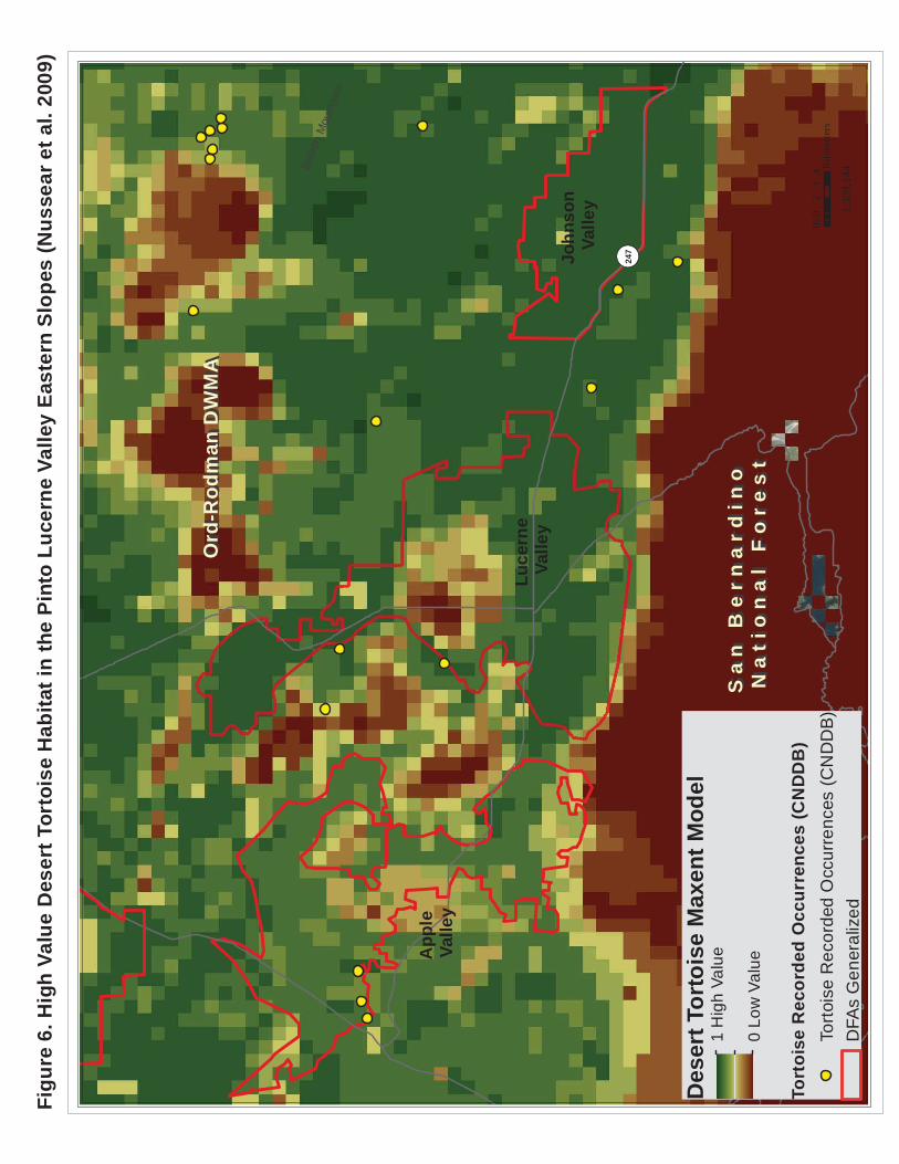
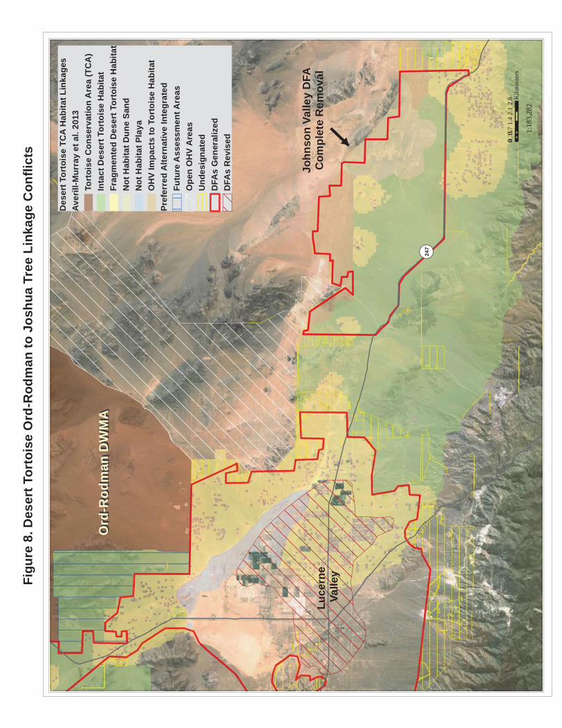
It is Nussear et al. 2009, not 2001. Nussear et al. (2009) identifies much of the Apple Valley, Lucerne Valley and Johnson Valley DFAs as highly suitable habitat for tortoise (Figure 6). There are several areas where the Lucerne Valley and Johnson Valley DFAs conflict with two desert tortoise linkages in the Western Mojave Recovery Unit, Fremont-Kramer to Ord-Rodman Linkage and the Ord-Rodman to Joshua Tree linkage (Figure 7). The upper arm of the Lucerne Valley DFA coincides with intact desert tortoise habitat in the Fremont Kramer to Ord-Rodman Linkage and the FAA that is sandwiched between this DFA and the Ord-Rodman TCA is made up almost entirely of intact desert tortoise. This area of the Lucerne Valley DFA and the FAA is also in conflict with the Desert Linkage Network, Bighorn sheep intermountain habitat, and other Covered Species (e.g., Bendire’s thrasher, burrowing owl, golden eagle). In addition, the Lucerne Valley DFA as currently proposed completely severs the northern segment of the Ord-Rodman to Joshua Tree Linkage and would severely compromise the function of this linkage (See AM-DFA-ICS-6 Comment). The great majority of the Johnson Valley DFA is also intact desert tortoise habitat that falls within the Ord-Rodman to Joshua Tree Linkage. These DFAs must be reconfigured to AVOID these Desert Tortoise Linkages. In addition, the southern segment of the Ord-Rodman to Joshua Tree Linkage to the southeast of the Johnson Valley DFA is also identified as “Fragmented Desert Tortoise Habitat” (Figures C-35 and C-36) and much of it is delineated as “Undesignated” land, which would be available for “disposal”. While there are ACEC and NLCS lands proposed on the western fringe of the desert tortoise linkage, these proposed designations do not capture the most permeable route for the tortoise. While the raster data for the least-cost corridor analyses was not available on Data Basin as part of the Desert Tortoise TCA and Linkages data, I know this analysis well enough to know how it looks when converted to a shapefile. BLM has checkerboard ownership in this segment of the linkage and several of the adjacent parcels are NOT developed that would allow for the design and implementation of a “landscape linkage corridor…at least 1.2 miles wide” (Objective L1.2). As such, this segment of the linkage should be identified as a Conservation Planning Area. All desert tortoise linkages should be included in the Reserve Design in order to achieve Goal DETO2 (Desert Tortoise Linkages), “Maintain functional linkages between Tortoise Conservation Areas to provide for long-term genetic exchange, demographic stability, and population viability within Tortoise Conservation Areas”. The Western Mojave Recovery Unit and the associated linkages may be especially important to allow the tortoise to adapt to climate change, as indicated in Section III.7.4, “According to climate change models, conditions currently present in parts of the Colorado/Sonoran Desert are expected to expand to other parts of the Plan Area (Allen 2012), with an associated shift in vegetation (Notaro et al. 2012). AM-DFA-ICS-5 Comment: If “Covered Activities, except for transmission projects in existing transmission corridors, will avoid the desert tortoise conservation areas (TCAs) and the desert tortoise linkages identified in Appendix H”, why are ANY DFAs sited in TCAs and linkages? Further, why are any areas of the tortoise linkages “Undesignated” and therefore “available for disposal”? As one of the Reserve Drivers, all desert tortoise TCAs and linkages in ALL Recovery Units should be included in the Reserve Design! AM-DFA-ICS-6 Comment (1): A population viability analysis (PVA) should have been conducted Plan-Wide for desert tortoise as part of the DRECP process. This information should
Bullio
n M
ount
ains
B
¬ «247
01
23
40.
5K
ilom
eter
s
1:30
9,14
4
App
le
Valle
y
Luce
rne
Valle
y
Des
ert T
orto
ise
Max
ent M
odel
1
Hig
h Va
lue
0 Lo
w V
alue
Tort
oise
Rec
orde
d O
ccur
renc
es (C
ND
DB
)To
rtois
e R
ecor
ded
Occ
urre
nces
(CN
DD
B)
DFA
s G
ener
aliz
ed
Ord
-Rod
man
DW
MA
Ord
-Rod
man
DW
MA
Sa
n B
ern
ard
ino
S
an
Be
rna
rdin
o
Na
tio
na
l F
ore
st
Na
tio
na
l F
ore
st
John
son
Valle
y
Figu
re 6
. Hig
h Va
lue
Des
ert T
orto
ise
Hab
itat i
n th
e Pi
nto
Luce
rne
Valle
y Ea
ster
n Sl
opes
(Nus
sear
et a
l. 20
09)
Bullio
n M
ount
ains
¬ «247
01
23
40.
5K
ilom
eter
s
1:30
0,00
0
App
le
Valle
y
Luce
rne
Valle
yD
eser
t Tor
tois
e TC
A H
abita
t Lin
kage
sAv
erill
-Mur
ray
et a
l. 20
13To
rtoi
se C
onse
rvat
ion
Are
a (T
CA
)In
tact
Des
ert T
orto
ise
Hab
itat
Frag
men
ted
Des
ert T
orto
ise
Hab
itat
Not
Hab
itat D
une
Sand
Not
Hab
itat P
laya
OH
V Im
pact
s to
Tor
tois
e H
abita
tTo
rtois
e R
ecor
ded
Occ
urre
nces
(CN
DD
B)
Pref
erre
d A
ltern
ativ
e In
tegr
ated
Futu
re A
sses
smen
t Are
asO
pen
OH
V A
reas
Und
esig
nate
dD
FAs
Gen
eral
ized
DFA
s R
evis
ed
Ord
-Rod
man
DW
MA
Ord
-Rod
man
DW
MA
Sa
n B
ern
ard
ino
Na
tio
na
l F
ore
st
Sa
n B
ern
ard
ino
Na
tio
na
l F
ore
st
John
son
Valle
y D
FAC
ompl
ete
Rem
oval
Figu
re 7
. Des
ert T
orto
ise
TCA
Lin
kage
Con
flict
s in
the
Pint
o Lu
cern
e Va
lley
East
ern
Slop
es

SC Wildlands Comments on Draft EIR/EIS for DRECP Page 19
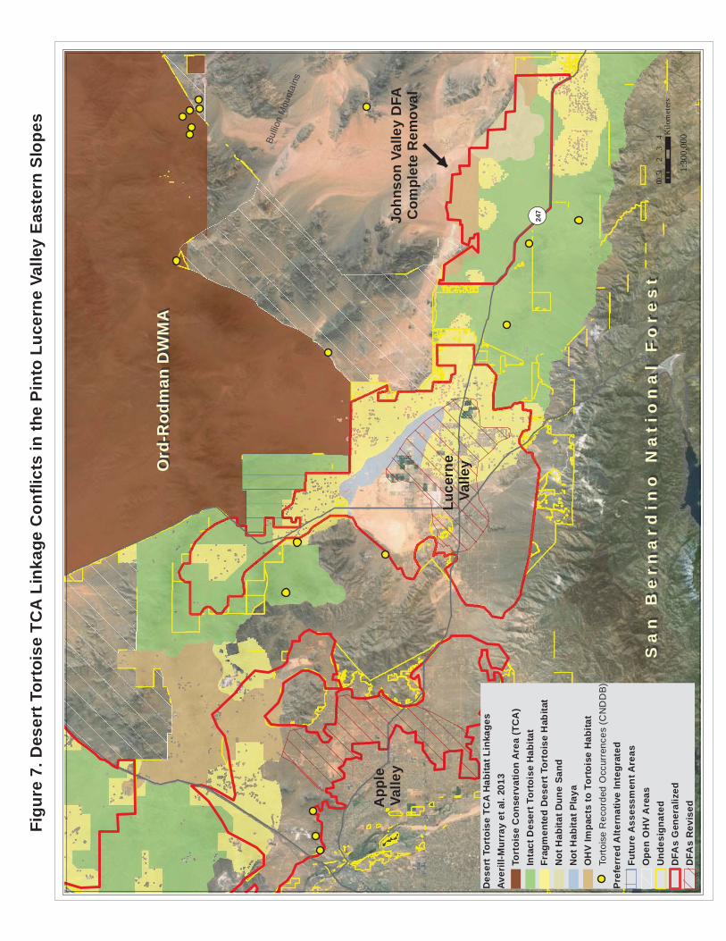
have been presented in Vol. III to assess existing recovery efforts under baseline conditions and in Vol. IV to compare the potential impacts of habitat loss proposed under each Alternative. AM-DFA-IC-6 refers to “the maintenance of long term viable desert tortoise populations within the affected linkage”. While each of the desert tortoise linkages identified in Figure H-7 provide live-in and move-through habitat, these linkage are intended to provide connectivity between the TCAs to maintain the viability of the entire population. As stated in Section III.7.6.1.1, “ Linkage habitat are important areas identified by Recovery Implementation Teams, such as important genetic linkages identified by Hagerty et al. 2010 (cited in USFWS 2011a) that are important to maintaining the species’ distribution throughout its range”. A PVA for a “linkage population” doesn’t make sense. AM-DFA-ICS-6 Comment (2): “Covered Activities that would compromise the viability of a linkage population or the function of the linkage, as determined by the DRECP Coordination Group, are prohibited and would require reconfiguration or re-siting”. AM-DFA-ICS-7: Covered Activities will be sited in lower quality desert tortoise habitat in desert tortoise linkages and the Ord-Rodman TCA, identified in Appendix H. COMMENT: Identified where? Figure H-6 Desert Tortoise Survey Areas? Figure H-7? Neither of these maps depict “lower quality desert tortoise habitat”. If Figure H-6, is the “lower quality desert tortoise habitat in the “No Survey Areas” identified in the legend, or in the “No Survey Areas” and “Clearance Survey Only Areas”. If so, that would imply that the “Protocol Survey Areas” are higher quality desert tortoise habitat, which would reinforce comments made above for AM-DFA-ICS-5 and AM-DFA-ICS-6. Figure H-7, Desert Tortoise Conservation Areas, identifies the majority of the Apple, Lucerne, Johnson Valley DFAs as Protocol Survey Areas with some smaller areas identified as Clearance Survey Areas. The Lucerne Valley DFA as currently proposed completely severs the northern segment of the Ord-Rodman to Joshua Tree Linkage (Figure 8) and would severely compromise the function of this linkage (AM-DFA-ICS-6). The analyses conducted by USFWS (Averill-Murray et al. 2013) indicate that this area is relatively permeable to tortoise movement and this entire area is identified as highly suitable in the desert tortoise Maxent model (Nussear et al.2009). This area of the linkage is identified as Fragmented Desert Tortoise Habitat in Attachment B to Appendix D but an evaluation of aerial imagery in this area reveals that existing rural development here is relatively sparse and the majority of residential properties in this area are unfenced. This area of the linkage should not be written off, especially since one of the overarching Biological Goals is to, “Preserve, restore, and enhance natural communities and ecosystems including those that support Covered Species within the Plan Area”. The distance between the Ord-Rodman TCA and the Intact Desert Tortoise Habitat in the Old Woman Springs Wildlife Linkage ACEC is roughly 7 miles, fully within the movement capability of an individual tortoise. Sazaki et al. (1995) estimated dispersal distance for pre-breeding male tortoises to be between 6.21-9.32 miles. This DFA must be reconfigured to completely avoid this linkage. Further, the playa habitat to the west of the tortoise linkage, although not tortoise habitat, could buffer the tortoise linkage from Covered Activities in the remaining DFA, while also providing habitat for other Covered Species (e.g., burrowing owl, pallid bat, Townsend’s big-eared bat) .
Bullio
n M
ount
ains
¬ «247
00.
71.
42.
12.
80.
35K
ilom
eter
s
1:18
3,28
2
Luce
rne
Valle
y
Des
ert T
orto
ise
TCA
Hab
itat L
inka
ges
Aver
ill-M
urra
y et
al.
2013
Tort
oise
Con
serv
atio
n A
rea
(TC
A)
Inta
ct D
eser
t Tor
tois
e H
abita
tFr
agm
ente
d D
eser
t Tor
tois
e H
abita
tN
ot H
abita
t Dun
e Sa
ndN
ot H
abita
t Pla
yaO
HV
Impa
cts
to T
orto
ise
Hab
itat
Pref
erre
d A
ltern
ativ
e In
tegr
ated
Futu
re A
sses
smen
t Are
asO
pen
OH
V A
reas
Und
esig
nate
dD
FAs
Gen
eral
ized
DFA
s R
evis
ed
Ord
-Rod
man
DW
MA
Ord
-Rod
man
DW
MA
John
son
Valle
y D
FAC
ompl
ete
Rem
oval
Figu
re 8
. Des
ert T
orto
ise
Ord
-Rod
man
to J
oshu
a Tr
ee L
inka
ge C
onfli
cts
SC Wildlands Comments on Draft EIR/EIS for DRECP Page 20
The Johnson Valley DFA as currently proposed (Figures 7 and 8) would severely compromise the function of the Or-Rodman to Joshua Tree linkage. This proposed DFA is roughly 27,258 acres, much of it Intact Desert Tortoise Habitat as identified in Attachment B to Appendix D and Figures C-35 and C-36. The area of intact habitat in the linkage currently ranges in width from roughly 5 to 8 miles wide. The proposed Johnson Valley DFA would reduce the width of the linkage to about 3 miles wide in this stretch of the linkage. The average home range size for desert tortoise in the Western Mojave Recovery Unit is 125 acres (USFWS 1994, Boarman 2002). Would this significant reduction of intact habitat allow for “the maintenance of long-term viable desert tortoise populations within the affected linkage (AM-DFA-ICS-6)”? This entire DFA is identified as highly suitable in the desert tortoise Maxent model (Nussear et al.2009) and the great majority of it is BLM land. This linkage must not be written off, especially since one of the overarching Biological Goals is to, “Preserve, restore, and enhance natural communities and ecosystems including those that support Covered Species within the Plan Area”. We recommend complete removal of this DFA to avoid this linkage in order to “maintain functional linkages between Tortoise Conservation Areas to provide for long-term genetic exchange, demographic stability, and population viability within Tortoise Conservation Areas” and meet the intent of Goal DETO2 (Desert Tortoise Linkages).
Objective DETO2.1a (Desert Tortoise Linkages): Protect, manage and acquire desert tortoise habitat within the following linkages (see Figure C-34) with special emphasis placed on areas of high habitat potential and areas identified as integral to the establishment and protection of a viable linkage network (see Figure C-36). Ensure the long-term connectivity of Tortoise Conservation Areas by maintaining desert tortoise habitat that is of sufficient size and contiguity for maintenance of viable populations within each linkage. o Ord-Rodman to Superior-Cronese to Mojave National Preserve o Superior-Cronese to Mojave National Preserve to Shadow Valley to Death Valley National Park Linkage o Joshua Tree National Park and Pinto Mountains Desert Wildlife Management Area (DWMA) to Chemehuevi Linkage o Death Valley National Park to Nevada Test Site DETO2.1a COMMENT: Figure C-34 depicts 9 different desert tortoise linkages yet only 4 are listed here, all of which occur in the Eastern Mojave Recovery Unit and the Colorado Desert Recovery Unit. Why are none of the linkages associated with the Western Mojave Recovery Unit included here? For example, the Ord-Rodman to Joshua Tree Linkage includes a contiguous, fairly wide strand that is either intact desert tortoise habitat or fragmented tortoise habitat with High Habitat Potential (C-36). As a “Reserve Driver” Covered Species and Non-Covered but Addressed Species associated with the Western Mojave are reliant and at the mercy of the agencies to create a VIABLE PLAN-WIDE Linkage Network for ALL native species and ecological process of interest in the DRECP Region.
Objective DETO2.1b (Desert Tortoise Linkages): Protect, maintain, and acquire all remaining desert tortoise habitat within linkages already severely compromised, specifically the following (see Figure C-34): o Ivanpah Valley Linkage o Chemehuevi to Chuckwalla Linkage

SC Wildlands Comments on Draft EIR/EIS for DRECP Page 21
o Pinto Wash Linkage DETO2.1b COMMENT: Why is the Ord-Rodman to Joshua Tree Linkage not included here? Or, the Fremont Kramer to Ord-Rodman Linkage? This objective should read: Protect, maintain and restore all remaining desert tortoise habitat within linkages already severely compromised, specifically the following (see Figure C-34 through C-36): o Ivanpah Valley Linkage o Chemehuevi to Chuckwalla Linkage o Pinto Wash Linkage *ADD Ord-Rodman to Joshua Tree Linkage *ADD Fremont Kramer to Ord-Rodman Linkage
Objective DETO2.1c (Desert Tortoise Linkages): Protect intact habitat (see Figure C-35) within the following linkages to enhance the population viability of the Ord-Rodman Tortoise Conservation Area. o Ord-Rodman to Joshua Tree Linkage o Fremont Kramer to Ord-Rodman Linkage DETO2.1c COMMENT: The DRECP refers the reader to Figure C-35 Desert Tortoise Biological Goals and Objectives but the LEGEND on this map refers to Objective DETO2.1d in relation to the Ord-Rodman to Joshua Tree Linkage and the Fremont Kramer to Ord-Rodman Linkage but DETO2.1d doesn’t exist under Goal DETO2 (Desert Tortoise Linkages). However, Figure C-36 Desert Tortoise Biological Goals and Objectives and Habitat Potential does identify DETO2.1c for these two desert tortoise linkages. There is no explanation for the legend in Figure C-36 but one must assume that the High and Low following the BGOs relate to High Habitat Potential and Low Habitat Potential. The “Fragmented Habitat” in both of these linkages identified in Figure C-35 is also identified as having High Habitat Potential in Figure C-36. Protecting only “intact habitat” in the Ord-Rodman to Joshua Tree Linkage will do nothing to enhance the population viability of the Ord-Rodman Tortoise Conservation Area if ALL of the habitat within the linkage between the TCA and the intact habitat is entirely within a DFA! Shouldn’t the tortoise linkages enhance the population viability of all of the TCAs (e.g., Joshua Tree, Fremont Kramer)? Step-Down Biological Objective DETO-B: Protect, maintain, and manage for the duration of the NCCP on BLM LUPA conservation designation lands and prioritize for conservation on non-BLM lands substantial representative areas of desert tortoise habitat in the following areas: O Desert Tortoise Research Natural Area O Fremont-Kramer Desert Wildlife Management Area and Critical Habitat Unit O Ord-Rodman Desert Wildlife Management Area and Critical Habitat Unit o Portions of the Superior-Cronese Desert Wildlife Management Area and Critical Habitat Unit o Portions of the Chuckwalla Desert Wildlife Management Area and Critical Habitat Unit o Portions of intact desert tortoise habitat in the Colorado Desert o Fremont Kramer to Ord-Rodman Linkage o Chemehuevi to Chuckwalla Linkage o Portions of the Ord-Rodman to Joshua Tree Linkage – WHY only portions?
SC Wildlands Comments on Draft EIR/EIS for DRECP Page 22
Step-Down Biological Objective DETO-C: Establish long-term conservation to protect, manage, and enhance habitat value for 266,000 acres of desert tortoise habitat that contributes to the DRECP NCCP reserve design in and around the following areas: Desert Tortoise Research Natural Area, Fremont-Kramer Desert Wildlife Management Area and Critical Habitat Unit, Ord-Rodman to Joshua Tree Linkage, Fremont Kramer to Ord-Rodman Linkage, Pinto Wash Linkage, and Chemehuevi to Chuckwalla Linkage. COMMENT: FAA just outside of Ord-Rodman ACEC/NLCS is intact desert tortoise habitat, mountain and intermountain habitat for bighorn sheep, part of land facet linkages and habitat for numerous focal species in the Desert linkage Network, and other Covered Species (e.g., golden eagle, burrowing owl). In the Overview of the Preferred Alternative II.3.1.1., it says “The current known value of these areas for ecological conservation is moderate to low”. The current known value of this FAA for ecological conservation is very high.
Step-Down Biological Objective DETO-D: Maintain and manage for resource values on BLM LUPA conservation designation lands habitat for desert tortoise in the following areas: o Remainder of the Ord-Rodman to Joshua Tree Linkage o Fremont Kramer to Ord-Rodman Linkage
Figure 9 shows areas of the Apple and Lucerne Valley DFAs that conflict with the Mohave ground squirrel. While the Pinto Lucerne Valley and Eastern Slopes Subarea is outside of the Mohave Ground Squirrel Conservation Area, there are historical recorded occurrences in this subarea and specifically in the Apple Valley and Lucerne Valley DFAs. This subarea lies at the southernmost extent of this species distributional range (Inman et al. 2013) and several areas in this subregion are expected to remain relatively stable (Davis et al. in press) under an uncertain climate. We trust that the above discussion of Reserve Drivers provides sufficient evidence and justification for modification to the Reserve Design in the Pinto Lucerne Valley and East Slopes Ecoregion Subarea. We have also included a composite figure for the other species listed in Table 4 that are also expected to benefit from these modifications to the Apple and Lucerne Valley DFAs and the removal of the Johnson Valley DFA (Figures 10). Summary: Under the current pace of development, natural resource agencies need to make near-term decisions in the face of existing land use pressures as well as long-term change. The one thing that is certain about climate change is that it is highly uncertain. Penrod et al. (2012) did not design corridors using complex models of future climate and biotic responses to climate change. Such an approach uses 4 models, with outputs of each model used as input to the next model. Specifically modeled future emissions of CO2 (1st model) drive global circulation models (2nd) which are then downscaled using regional models (3rd) to predict future climate. Then climate envelope models (4th) are used to produce maps of the expected future distribution of species. We avoided this approach for two reasons: (1) Each of the 4 models involves too much uncertainty, which is compounded from model to model and from one predicted decade to the next. In 1999 the IPCC developed 7 major scenarios of possible CO2 emissions during 2000-2011. The total emissions over the century vary by a factor of 6 among scenarios. Actual emissions during 2000-2010 were higher than the most pessimistic scenario. For a single emission scenario, different air-ocean global circulation models produce markedly different climate projections (Raper & Giorgi 2005). Finally climate envelope models may perform no
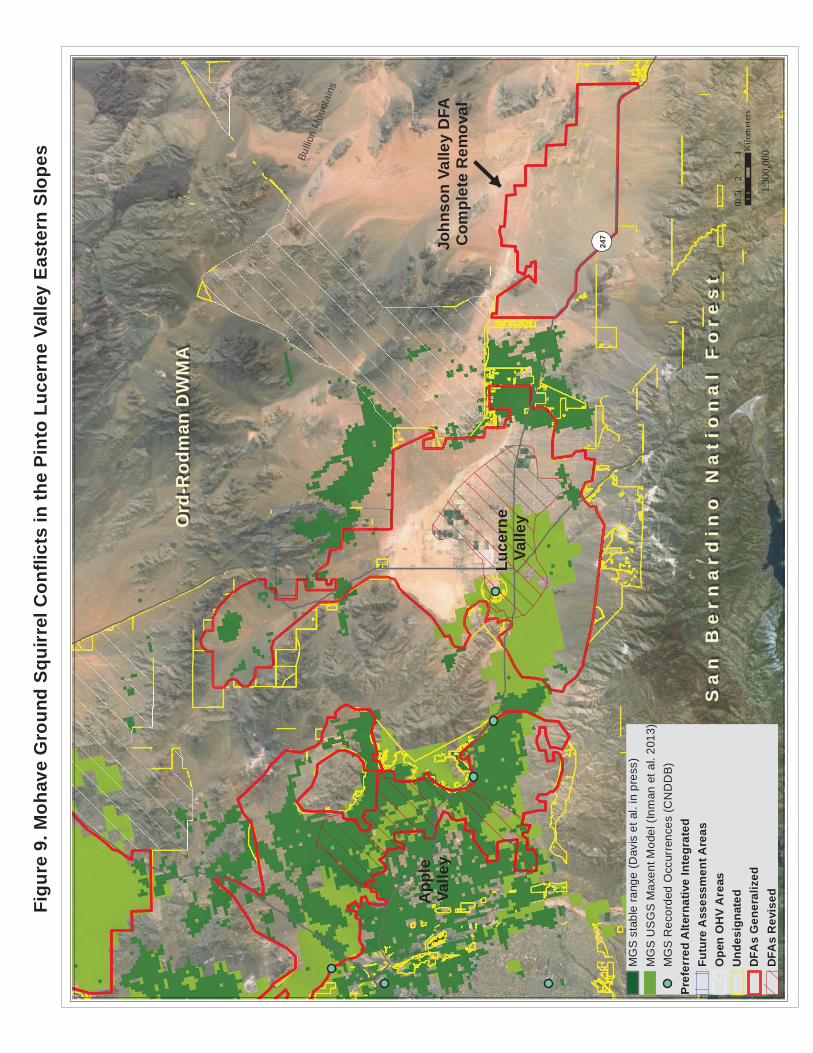
Bullio
n M
ount
ains
¬ «247
01
23
40.
5K
ilom
eter
s
1:30
0,00
0
App
le
Valle
y
Luce
rne
Valle
y
MG
S s
tabl
e ra
nge
(Dav
is e
t al.
in p
ress
)M
GS
US
GS
Max
ent M
odel
(Inm
an e
t al.
2013
)M
GS
Rec
orde
d O
ccur
renc
es (C
ND
DB
)Pr
efer
red
Alte
rnat
ive
Inte
grat
edFu
ture
Ass
essm
ent A
reas
Ope
n O
HV
Are
asU
ndes
igna
ted
DFA
s G
ener
aliz
edD
FAs
Rev
ised
Ord
-Rod
man
DW
MA
Ord
-Rod
man
DW
MA
Sa
n B
ern
ard
ino
Na
tio
na
l F
ore
st
Sa
n B
ern
ard
ino
Na
tio
na
l F
ore
st
John
son
Valle
y D
FAC
ompl
ete
Rem
oval
Figu
re 9
. Moh
ave
Gro
und
Squi
rrel
Con
flict
s in
the
Pint
o Lu
cern
e Va
lley
East
ern
Slop
es
Bullio
n M
ount
ains
¬ «247
01
23
40.
5K
ilom
eter
s
1:30
7,38
0
App
le
Valle
y
Luce
rne
Valle
y
DR
ECP
Ecol
ogic
al B
asel
ine
Com
posi
teSp
ecie
sCou
nt0
- 34
- 56 7
- 910
- 14
TES
Spe
cies
Occ
urre
nces
(CN
DD
B)
Pref
erre
d A
ltern
ativ
e In
tegr
ated
Futu
re A
sses
smen
t Are
asU
ndes
igna
ted
DFA
s R
evis
edD
FAs
Gen
eral
ized
Ord
-Rod
man
DW
MA
Ord
-Rod
man
DW
MA
Sa
n B
ern
ard
ino
Na
tio
na
l F
ore
st
Sa
n B
ern
ard
ino
Na
tio
na
l F
ore
st
John
son
Valle
y C
ompl
ete
Rem
oval
Figu
re 1
0. C
over
ed S
peci
es C
ount
in th
e Pi
nto
Luce
rne
Valle
y Ea
ster
n Sl
opes

SC Wildlands Comments on Draft EIR/EIS for DRECP Page 23
better than chance (Beale et al. 2008). Because these sophisticated models have not simulated the large shifts during the last 100,000 years of glacial oscillations, Overpeck et al. (2005:99) conclude the “lesson for conservationists is not to put too much faith in simulations of future regional climate change” in designing robust conservation strategies. (2) These models produce outputs at a spatial resolution too coarse to support decision making in the California desert. The downscaled climate projections have minimum cells sizes measured in square kilometers. Penrod et al. (2012) used an alternative “land facets” approach to design climate-robust linkages that maximize continuity of the enduring features (topographic elements such as sunny lowland flats, or steep north-facing slopes) that will interact with future climate to support future biotic communities. Enduring features reflect the stable state factors, namely topography, geology, and time. The uncertainties of the land facets approach are almost certainly less than the 6-fold uncertainty in emission scenarios multiplied by the uncertainty in general circulation models multiplied by the uncertainty in regional downscaling multiplied by the uncertainty in climate envelope models. The Desert Linkage Network (Penrod et al. 2012) was designed to accommodate species movements, range shifts, and continued ecological functions during climate change. The Plan Wide Preferred Alternative includes 2,024,000 acres of DFAs and transmission corridors but says only about 177,000 acres will actually be impacted. If 177,000 acres is all that is truly needed to meet renewable energy goals, then ALL areas of the Desert Linkage Network (Penrod et al. 2012), Desert Tortoise TCA and Linkages (Averill-Murray et al. 2013), Bighorn sheep mountain habitat and intermountain habitat (CDFW 2013), and Mohave ground squirrel important habitat (Inman et al. 2013, UCSB 2013) should be included in the Reserve Design. Strategically conserving and restoring functional connections between large wildlands is an effective countermeasure to the adverse affects of habitat loss and fragmentation, and it is an essential mitigation measure for climate change. In Volume 1 Chapter 1.2, Legal Framework, the DRECP says, “To approve the DRECP as an NCCP, CDFW must find, based upon substantial evidence in the record, that the NCCP:
4. Develops reserve systems and conservation measures in the Plan Area that provide for, as needed for the conservation of species, all of the following: (a) conserving, restoring, and managing representative natural and seminatural landscapes to maintain the ecological integrity of large habitat blocks, ecosystem function, and biological diversity; (b) establishing one or more reserves or other measures that provide equivalent conservation of Covered Species within the Plan Area and linkages between them and adjacent habitat areas outside of the Plan Area; (c) protecting and maintaining habitat areas large enough to support sustainable populations of Covered Species; (d) incorporating a range of environmental gradients (such as slope, elevation, and aspect) and high habitat diversity to provide for shifting species distributions due to changed circumstances; and (e) sustaining the effective movement and interchange of organisms between habitat areas in a manner that maintains the ecological integrity of the habitat areas within the Plan Area”. CDFW cannot approve the DRECP as an NCCP because there is NOT substantial evidence in the record that “ALL” of the above conditions have been met.
SC Wildlands Comments on Draft EIR/EIS for DRECP Page 24
Thank you for the opportunity to provide comments on the DRAFT EIR/EIS for the DRECP. SC Wildlands is available to consult with the natural resource agencies to ensure that connectivity is adequately and accurately addressed in the DRECP. Respectfully Submitted, Kristeen Penrod Director, SC Wildlands [email protected] Direct line: 206/285-1916 Literature Cited
Averill-Murray, R.C., C.R. Darst, N. Strout, and M. Wong. 2013. Conserving population linkages for the Mojave desert tortoise (Gopherus agassizii). Herpetological Conservation and Biology 8(1):1-15. Beale, C. M., J. J. Lennon, and A. Gimona. 2008. Opening the climate envelope reveals no macroscale associations with climate in European birds. Proceedings of the National Academy of Sciences 105:14908-14912. Beier, P., and B. Brost. 2010. Use of land facets to plan for climate change: conserving the arenas, not the actors. Conservation Biology 24:701-710.
Boarman, W. I. 2002. Desert tortoise (Gopherus agassizii). In Boarman, W. I. and K. Beaman (eds), The sensitive plant and animal species of the Western Mojave Desert. U. S. Geological Survey, Western Ecological Research Center, Sacramento, Ca. California Department of Fish and Wildlife, April 2013 Draft, A Conservation Plan for Desert Bighorn Sheep in California
California Natural Resources Agency. 2014. Safeguarding California: Reducing Climate Risk An update to the 2009 California Climate Adaptation Strategy. California Natural Resources Agency. 2009. 2009 California Adaptation Strategy: A Report to the Governor of the State of California in Response to Executive Order S-13-2008 Davis, F. et al. In Press. Cumulative Biological Impacts Framework for Solar Energy in the California Desert. Field, C.B., G.C. Daily, S. Gaines, P.A. Matson, J. Melack, and N.L. Miller. 1999. Confronting climate change in California: ecological impacts on the Golden State. Union of Concerned Scientists and Ecological Society of America, Washington D.C. Heller, N. E. and E. S. Zavaleta. 2009. Biodiversity management in the face of climate change: a review of 22 years of recommendations. Biological Conservation 142:14-32. Hunter, Jr., M. L., G. L. Jacobson, Jr., and T.Webb, III. 1988. Paleoecology and the coarse-filter

SC Wildlands Comments on Draft EIR/EIS for DRECP Page 25
approach to maintaining biological diversity. Conservation Biology 2:375-385.
Inman, RD, Esque TC, Nussear KE, Leitner P, Matocq MD, Weisberg PJ, Diltd TE, Vandergast AG. 2013. Is there room for all of us? Renewable energy and Xerospermophilus mohavensis. Endang Species Res 20:1-18.
Notaro, M., A. Mauss, and J.W. Williams. 2012. “Projected Vegetation Changes for the American Southwest: Combined Dynamic Modeling and Bioclimatic-Envelope Approach.” Ecological Applications 22:1365–1388. Nussear, K.E., T.C. Esque, R.D. Inman, L. Gass, K.A. Thomas, C.S.A. Wallace, J.B. Blainey, D.M. Miller, and R.H.Webb. 2009. Modeling habitat of the desert tortoise (Gopherus agassizii) in the Mojave and parts of the Sonoran Deserts of California, Nevada, Utah, and Arizona. U.S. Geological Survey Open-File Report 2009-1102. Overpeck, J., J. Cole, and P. Bartlein. 2005. A ‘paleoperspective’ on climate variability and change. Pages 91-108 in T. E. Lovejoy and L. Hanna, editors. Climate change and biodiversity. Yale University Press, New Haven, Connecticut. Penrod, K., P. Beier, E. Garding, and C. Cabañero. 2012. A Linkage Network for the California Deserts. Produced for the Bureau of Land Management and The Wildlands Conservancy. Produced by Science and Collaboration for Connected Wildlands, Fair Oaks, CA www.scwildlands.org and Northern Arizona University, Flagstaff, Arizona http://oak.ucc.nau.edu/pb1/. Penrod, K., C. Cabañero, P. Beier, C. Luke, W. Spencer, and E. Rubin. 2005. South Coast Missing Linkages Project: A Linkage Design for the San Bernardino-Granite Connection. South Coast Wildlands, Idyllwild, CA. www.scwildlands.org.
Raper, S. C. B., and F. Giorgi. 2005 Climate change projections and models. Pages 199-210 in T. E. Lovejoy and L. Hanna, editors. Climate change and biodiversity. Yale University Press, New Haven, Connecticut. Sazaki, M., W. I. Boarman, G. Goodlet, and T. Okamoto. 1995. Risk associated with long distance movements by desert tortoises. Proceedings of the 1994 Desert Tortoise Council Symposium 1995:33-48.
Seavy, N.E., T. Gardali, G.H. Golet, F.T. Griggs, C.A. Howell, R. Kelsey, S.L. Small, J.H. Viers and J.F. Weigand. 2009. Why Climate Change Makes Riparian Restoration More Important than Ever: Recommendations for Practices and Research. Ecological Restoration 27(3): 330-338.
U.S. Fish and Wildlife Service. 1994. Desert tortoise (Mojave population) recovery plan. Portland, Oregon. UCSB. 2013. Mojave ground squirrel Species Distribution Models.

SC Wildlands Comments on Draft EIR/EIS for DRECP Page 26
DRECP APPROACH Margules and Pressey 2000; Carroll et al. 2003; Moilanen et al. 2009
U.S. Fish and Wildlife Service. 2011. Revised recovery plan for the Mojave population of the desert tortoise (Gopherus agassizii). U.S. Fish and Wildlife Service, Pacific Southwest Region, Sacramento, California. 222pp.
1986. USFWS. Fish and Wildlife Coordination Act Report Mojave River Forks Dam Water Conservation Project. Prepared for Army Corps of Engineers. Prepared by Ray Bransfield, US Fish and Wildlife Service.