scour of rock at bridge piers and abutments
TRANSCRIPT

Scour of Rock at Bridge Piers and Abutments
Scour of Rock at Bridge Piers and Abutments
Tony L. Beckham Former Research Geologist
Geotechnology Section University of Kentucky Transportation Center College of Engineering
Tommy C. Hopkins Former Research Engineer
Program Manager
Geohazards 2009

http://www.ktc.uky.edu/Reports/KTC_99_57_ SPR_157_94.pdf

I 95 bridge collapse over Schoharie Creek Amsterdam, New York--April 5, 1987
Focused national attendance on bridge scour
Ten Fatalities

I 95 bridge collapse -- Causes
Pier 3-- bearing on erodible soil.
“Layers of gravel, sand and silt, interbedded with folded and tilted till.”
High velocity floodwaters penetrated “bearing stratum.”

Lessons Learned
• Periodic Bridge inspections
• Erosion protection measures
• Selecting critical storm
• Locating design footings “deep”enough to avoid loss of support
• Understanding the geology and mechanical properties of bearing stratum
Importance of:

…. expansion of I 75 from 4 lanes to 6 lanes in Fayette Co., Ky…...
….What else motivated this study?
…required new bridge over the Ky river..

Place pier foundation deep into bedrock to avoid scour failure?
Limestone
Depth?
Place pier foundation on or near top of rock?
Depth?

..Ky ---1100 miles of navigable streams-- 2nd only to Alaska…..
..and thousands of miles of small streams, or tributaries….

Scourability of Rock? Guidelines?Scourability of Rock? Guidelines?
http://www.fhwa.dot.gov/engineering/hydraulics/ policymemo/rscour.cfm
Hardest of rocks can scour
No single index property generally can be used to assess the potential for rock scour
FHWA MEMORANDUM HNG-31
July 19, 1991 (Last revised 11/22/2005)

FHWA MEMORANDUM HNG-31 July 19, 1991 (Last revised 11/22/2005)
Scourability Potential, Sp MethodRQD < 50% Soil-like – Scourable
> 50% Rock-like – Sp Decreasing
Uc < 250 psi Soil-Like - Scourable> 250 psi Rock-like - Sp Decreasing
Soundness: 12 % Na 18% Mg
SDI< 90 % Soil-Like -- Sourable
LA Abrasion Loss % < 40 Scourable
Threshold Loss rate < Sourable

Scourability of Rock?Scourability of Rock?• Subsurface Investigation –
ID rock type/
discontinuties/recovery
• Geological Formation—Rock Type
• Rock Quality Designation (RQD)
ASTM D6032-08
• Unconfined Compression Test• Slake Durability Index• Soundness• Abrasion • Observation of Past History and Performance

OBJECTIVESOBJECTIVES
If necessary, recommend revisions in design practices
Define the scope of the problem in KY
Observe the erosional nature of geological rock units in KY at selected bridge sites
General Assessment of the need to locate bridge foundations deep into bedrock General Assessment of the need to locate bridge foundations deep into bedrock
Examine the potential relationship between rock scour and Rock Quality Designation (RQD)

Majority of bridges in KY are small bridges
Perspective: About 92 % of the KY’s roadways are 2-lane roads; low traffic volume
Norway: total length = 3314 ft.
Scour---Large Bridges
Ohio River

Geology and Soils in Kentucky
Sedimentary KY Geology
Limestone, dolostone, sandstone, siltstone, shale (hard and clayey- like), coal
Soils in Kentucky are residual (90% clays and silty clays)
Depth to bedrock is generally shallow --- 0 to 30 feet (Exception: Along major streams and in far Western KY)

IllinoisanIce Sheet
No glaciers advanced into KY
Ohio River
Kentucky
Ice SheetsPre-Illinoisan
Illinoisan Wisconsin

KY
Older GlaciationsOlder Glaciations
Illinoisan

Ordovician- 500 mil.
Cretaceous135 mil.
Mississippi 345 mil.
Pennsylvanian 310 mil.
Generally, ages of bedrock range from 310 to 500 million years
Devonian 405 mil.
Tertiary (12 thou.) & 12 Quaternary (10-65 mil.)
Alluvium
Silurian 425 mil.
Many streams cut down to a quasi-scour resistant layer ????

Rock Scour
2 B
illio
n Ye
ars
Permian
Pennsylvanian
Mississipian
Older Precam.
Devonian
Younger Precam.
Cambrian Grand Canyon
Ord
ovic
ian-
500
mil.
?Si
luri
an 4
25 m
il.?

ROCK SCOUR HAZARD RATING SYSTEM
(Numerical rating system)
Identify locations where rock scour may bea hazard
provide a means of evaluating rock scour
establish a priority list for remediation
locate sites for detailed rock scour studies

County: Geology Description: Rt. # Stream/River: Bridge # Date: Photo #’s
Proximity:
Low/None 3 Point assesment:
Far 9 notes:
Near 27
Adjacent 81
Penetration, dp :None 3 Point assesment: Up to 2" 9 notes:Up to 6" 27 > 6" 81
Depth, dc: None 3 Point assesment: Exposed Footer 9 notes:Exposed to bottom of Footer 27Footer Fully Exposed 81
ds: None 3 Point assesment: Up to 2" 9 notes:Up to 6" 27> 6" 81
AADT: 400 3 Point assesment: 800 9 notes:1,200 27 1,600 81
Total Score: Low: 0-125
Rock Scour Catego ry: Moderate: 126 - 300High: 301 - 500
Comments:
Far F
Low, or No Scour
Far From Footer
Near Footer
Adjacent to Footer
3 points
9 points
27 points
81 points
>3'
< 3'
100 points under foter
Scour Coding SheetExponential Scoring
3 9 27 81
•Scour Proximity
• dc (above footer bottom)
• dp (penetration under footer)
• ds (depth below footer bottom)• AADT (average annual daily traffic)

Scour
Scour Coding Sheet
Low, or No Scour
Far From Footer
Near Footer
Adjacent to Footer
3 points
9 points
27 points
81 points
>3'
< 3'
100 points under foter
Rock Scour Proximity
Under Footer 100 points

None or slight rock scour
Small hole next to footer

Apparently footer bottom is not exposed
Scour depth at the bottom of footer

Scour depth below bottom of footer
Erosion penetration under footer bottom

http://www.fhwa.dot.gov/BRIDGE/mtguide.pdf

Preliminary visual ratings (A,B, and C) of 394 bridges: 34 bridges – high scour --- A or B
Detailed numerical rating high: 8 bridges


First pass through by a consultant: 2,877 Bridges — all Hwy districts
Another survey Hwy D-10 and D-12: 777 Bridges
Another 5400 bridges inspected: no ratings received

About 50 % of bridges surveyed initially by UKTC were single span
Perspective-Typical Bridges Viewed
Over 8000 bridges & culverts in KY
92 % of KY roadways are 2-lane roads
Rock
SoilFillExposed footer
Exposed rockstreambed

Two-Span Pier / Abutments on rock
Two-Span
Pier on Rock
Abutment on Pt- bearing Piles

Three-Span
Piers on Rock
Abutments on Pt-bearing Piles
Unstable Approach Embankment with Toe Erosion

RQD –
Rock Quality DesignationRQD –
Rock Quality Designation
RQD -- Indicator of:
• Relative frequency of discontinuities in rock mass
• Compressibilty of rock mass
FHWA MEMORANDUM HNG-31 July 19, 1991 (Last revised 11/22/2005)
RQD < 50% Assume soil-like--scour potential
• Indirectly may be used as a measure of scourability of rock mass
RQD > 50% Rock-like

RQD –
Rock Quality Designation --
ExampleRQD –
Rock Quality Designation --
ExampleCore Run = 60 inches (152.4 cm)
Core Recovery (in) Modified Core Recovery (in)10 -------------------------- 101 < 4 in-------------------- 03 < 4 in-------------------- 05 ---------------------------- 56 ----------------------------- 64 ----------------------------- 42 < 4 in --------------------- 03 < 4 in --------------------- 0 4 ----------------------------- 47 ----------------------------- 74 ----------------------------- 4
49 in.
Core Recovered = 49/60 = 82 %
40 in. RQD = 40/60 = 67 %
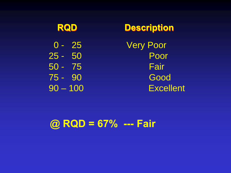
RQD DescriptionRQD Description
0 - 25 Very Poor 25 - 50 Poor50 - 75 Fair75 - 90 Good90 – 100 Excellent
@ RQD = 67% ---
Fair

Lawrence CountyKY 707 Long Branch Creek
Shale highly weatheredwith 1" - 3" sltstone layers
RQD
5
0
0
Scour Rating = 401
10
0Shale highly weathered with siltstone layers
5 Ft. Penetration Scour3 Ft. Scour Below Footer
Constructed 1930 - 1933?
Conemaugh Shale and Siltstone
Bridge # 64-B00035
Depth (ft.) …..Few Examples….

ds = 36”
Age = 70 yrs
RQD = 0
dp = 60”

Bath CountyUS 60 Hurricane Creek
Limestone with numerous clay shale seams
0
65
RQD0
7.5
Depth
Scour Rating = 458
Bridge Replaced in 1996
1.5
Limestone, weathered with clay shale seams
2 Ft. Penetration Scour Below Footer
Constructed 1925Bridge # 6-B00023

Age = 75 yrs
ds = 24”
d p= 2
4”
RQD = 0

Washington CountyCR 1243 Road Run Branch
Scour Rating = 327
0.0'-
5.0'Limestone,grey, coarse grained, 2 -
4 inches layers with clay shale seams 2 -
4 inches
Constructed 1935
7
RQD0
Depth
5.0
Lower Memberof Grant Lake Limestone
Bridge # 115-C00026
1 Ft. Vertical Scour, 3 Ft. Penetration Scour at Pier

Age = 65 yrs
RQD = 7
ds = 12”
Washington Co. CR 1243
dp = 36”

Harrison CountyCR 1006 Mouth of Cedar Creek
Scour Rating = 403
0.0'-
5.0'Limestone,grey, coarse grained, 2 -
4 inches layers with clay shale seams 2 -
6 inches
Constructed 1981
17
RQD0
Depth
5.0
Tanglewood Memberof Lexington Limestone
Bridge # 49-C00006

ds = 12”
Age = 19 yrs
dp =12”
RQD = 17

Jessamine CountyElm Fork Road Hickman Creek
Limestone with numerous clay shale partings
17
25
RQD0
10
Depth
5
Scour Rating = 377
0.5 Feet Scour below Abutment Footer2 Ft. Penetration Scour
Built 1987?Deck Only 1987?
Lexington Limestone
Bridge # 57-C00029 New Deck

ds = 6”
RQD = 17
dp =24”
Age>6
0 yr
s?

Cumberland CountyKY 704 Pine Branch
Leipers LimestoneLimestone with clay shale seams @ 0.2, 0.4, 0.7, 1.0, 1.1, 1.5 - 1.7, 2.0,2.2, 2.6, 2.7, 3.9,and 4.4 ft.
Scour Rating = 3072 Ft. Penetration Scour > 0.5 Ft. Scour below Footer
Constructed 1987?Deck Only?
Bridge # 29-B00055
22
RQD
1.5
6.5
Depth0
67
New Deck

ds = 8-10”
Age = 77 yrs
dp = 24”RQD = 22


Age = 22 yrs
RQD = 44
Owen Co. Ky 607
dp = ds = 0 ?

Adair CountyKY 704 Burns Creek
63
RQD
5
10
Depth
0
50
Bridge # 1-B00028
Scour Rating = 106Small (1 in.) Penetration Scour at Corner of Pier Footer2 in. Scour Below Footer
Constructed 1952
Chattanooga ShaleBlack Shale with fractures @ 1.9, 3.1, 3.5, 5.0, 5.7, 6.2, 6.6, 7.0,7.3, 8.7, and 9.0 ft.Mud seams @ 3.2, 5.1, and 9.2 ft.
Pyrite 1.9 - 3.1, and 4.9 ft.

dp = 1”
Age = 48 yrs
ds = 2”
RQD = 63-50

Bullitt CountyUS 31E Hough Run Creek
1.0 - 5.0 Limestone with clay shale seams@ 2.0,2.2,3.2,3.3,4.0
67
RQD0Depth
Scour Rating = 365
Route being reconstructed in 1996, 1997
0-1.0 Limestone, weathered with clay shale seams
1 Ft. Vertical Scour at Pier
Constructed 1924
5.04.7-4.8 Grey Clay shale4.8-5.0Grey Limestone
Bridge # 15-B00007
Age = 76 yrs
RQD = 67

ds = 12”
Age = 76 yrs
RQD = 67

Jackson Co.Age = 62 yrs
Rock Scour

Ds = dc = 14”RQD = 68

0100200300400500
0 20 40 60 80 10
Scou
r Sco
re,S
s
RQD
Ss = 422 -
4.9(RQD) +0.0277(RQD)2

0
10
20
30
40
0 10 20 30 40 50 60 70 80 90 100
ds
= 20.46 –
(2.94) Ln(RQD) 0.01 ≥
RQD ≤
92
Dep
th o
f Roc
k S
cour
, ds
RQD
FHWA KY*
KY* Modified RQD –
4-in pieces not included if it can be broken by hand

dp = 53.855e-0.069RQD
R2 = 0.61
010203040506070
0 20 40 60 80 100
Rock Quality Designation (RQD) %
Pe
ne
tra
tio
n S
co
ur,
dp
(in
.)

CONCLUSIONSCONCLUSIONS
Hundreds of bridge foundations are located on exposed rock in KY
Very Approximate relationships between RQD and rock scour depth and horizontal penetration were obtained
Very Approximate relationships between RQD and rock scour depth and horizontal penetration were obtained
FHWA guideline…RQD…appears reasonable

CONCLUSIONSGenerally, rock scour around bridge piers
and abutment footings is not a serious problem in KY
Current practices concerning locating depths of footers in bedrock appear sound following current guidelines of the KTC and FHWA
Periodic inspections of all KY bridges and their foundations should continue