scoping report for the esia albania (in english)
TRANSCRIPT


TAP TAP-FEED-AL-EIA-REP-7028
a
INDEX
EXECUTIVE SUMMARY I
1 INTRODUCTION 1
1.1 OVERVIEW OF THE PROJECT 1
1.2 ESIA PROCESS 3
1.2.1 Introduction 3
1.2.2 Approach to Scoping 5
1.3 SCOPING REPORT STRUCTURE 6
2 REGULATIONS AND GUIDELINES 7
2.1 ALBANIAN LEGAL FRAMEWORK ON EIA 7
2.2 EBRD PERFORMANCE REQUIREMENTS ON ENVIRONMENTAL AND SOCIAL
IMPACT ASSESSMENT 8
2.3 ESIA RELATED INTERNATIONAL CONVENTIONS/AGREEMENTS 9
3 DESCRIPTION OF SELECTED OPTIONS 10
3.1 INTRODUCTION 10
3.2 ONSHORE 10
3.2.1 Background 10
3.2.2 Methodology 12
3.2.3 Findings of Alternatives Assessment 12
3.2.4 Compressor Stations 13
3.3 OFFSHORE AND LANDFALL 14
3.3.1 Introduction 14
3.3.2 Route Selection Process and Results 15
3.3.3 Landfalls 15
4 PROJECT DESCRIPTION 17
4.1 INTRODUCTION 17
4.1.1 General Description 17
4.1.2 Safety 18
4.2 ONSHORE 18
4.2.1 Introduction 18
4.2.2 Pipeline Construction 19
4.2.3 Pre-Commissioning 24
4.2.4 Operation 24
4.2.5 Decommissioning 25
4.3 OFFSHORE 25
4.3.1 Introduction 25
4.3.2 Pipeline Construction 26
4.3.3 Pre-Commissioning 29
4.3.4 Operation 29
4.3.5 Decommissioning 29

TAP TAP-FEED-AL-EIA-REP-7028
b
5 BASELINE CONDITIONS 30
5.1 ONSHORE 30
5.1.1 Introduction 30
5.1.2 Environment 30
5.1.3 Socio Economic 36
5.1.4 Cultural Heritage 37
5.2 OFFSHORE 37
5.2.1 Environment 37
5.2.2 Socio Economic 40
5.2.3 Cultural Heritage 43
6 POTENTIAL IMPACTS AND MITIGATION MEASURES 44
6.1 INTRODUCTION 44
6.2 ONSHORE 46
6.2.1 Construction 46
6.2.2 Operation 55
6.3 OFFSHORE 59
6.4 MAIN FINDINGS OF PRELIMINARY ASSESSMENT 63
7 TERMS OF REFERENCE FOR ESIA 64
7.1 INTRODUCTION 64
7.2 ESIA OBJECTIVES 64
7.3 ESIA STEPS 65
7.4 SPECIALIST STUDIES 65
7.4.1 Desktop Studies 65
7.4.2 Field Studies 65
7.5 STAKEHOLDER ENGAGEMENT 66
7.5.1 Baseline Consultation 66
7.5.2 ESIA Report Disclosure and Consultation 67
7.6 STRUCTURE OF THE ESIA REPORT 67
7.7 PROVISIONAL ESIA SCHEDULE 68
8 STAKEHOLDER ENGAGEMENT 69
8.1 INTRODUCTION 69
8.2 STAKEHOLDER ENGAGEMENT PHASES FOR TAP PROJECT 69
8.2.1 Overview 69
8.2.2 Pre-scoping Consultation 70
8.3 SCOPING PHASE STAKEHOLDER ENGAGEMENT 72
8.3.1 Objectives 72
8.3.2 Stakeholder Engagement Activities 73
8.4 GRIEVANCE MECHANISM 75
8.5 RESOURCES AND RESPONSIBILITIES 75
8.6 PUBLIC COMMENTS AND SUGGESTIONS 75

TAP TAP-FEED-AL-EIA-REP-7028
c
LIST OF APPENDICES
APPENDIX A – Maps
APPENDIX B – Comments Form
APPENDIX C – List of Stakeholders
APPENDIX D – ESIA Action Plan
APPENDIX E - References
LIST OF TABLES
Table 1.1 Summary of the ESIA Process 4
Table 2.1 Albanian Legal Framework on Environmental Impact Assessment 8
Table 2.2 International Conventions and Agreements Signed/Ratified by Albania 9
Table 6.1 Potential Environmental Impacts and Mitigation Measures Related to
Onshore Construction and Pre-Commissioning 46
Table 6.2 Potential Socioeconomic Impacts and Mitigation Measures related to
Onshore Construction and Pre-Commissioning 51
Table 6.3 Potential Cultural Heritage Impacts and Mitigation Measures related to
Onshore Construction and Pre-Commissioning 54
Table 6.4 Potential Environmental Impacts and Mitigation Measures related to
Onshore Operation 55
Table 6.5 Potential Socioeconomic Impacts and Mitigation Measures related to
Onshore Operation 56
Table 6.6 Potential Cultural Heritage Impacts and Mitigation Measures related to
Onshore Operation and Decommissioning 58
Table 6.7 Potential Environmental, Socioeconomic and Cultural Heritage Impacts and
Mitigation Measures related to Offshore Construction 59
Table 6.8 Potential Environmental, Socioeconomic and Cultural Heritage Impacts and
Mitigation Measures Related to Offshore Operation 61
Table 7.1 Proposed EIA Report Structure 67
Table 7.2 ESIA and Stakeholder Consultation Schedule 68
Table 8.1 ESIA Stakeholder Engagement Phases 70
Table 8.2 Summary of Alternative Assessment Disclosure Issues 71
Table 8.3 Key Stakeholder Groups for ESIA Phase Engagement 72
Table 8.4 Scoping Meetings 73

TAP TAP-FEED-AL-EIA-REP-7028
d
LIST OF FIGURES
Figure 1.1 TAP in Albania (onshore) 2
Figure 1.2 TAP in Albania (offshore) 2
Figure 1.3 Schematics of the ESIA Process 4
Figure 3.1 Optional CS3 Locations 14
Figure 3.2 Landfall Alternatives 16
Figure 4.1 Regular Working Strip 20
Figure 4.2 Reduced Working Strip 20
Figure 4.3 Compressor Station - Typical Layout 21
Figure 4.4 Tunnel 23
Figure 4.5 Standard Shallow Water Pipe Lay Barge 26
Figure 4.6 Typical Pipe Laying Technique 27
Figure 4.7 Schematics of a Suction Dredging Operation 28
Figure 5.1 Fishery Production by Capture in Albania between 1970 and 2007 41
Figure 5.2 Shipping Lanes in the Adriatic and Ionian Sea 42

TAP TAP-FEED-AL-EIA-REP-7028
e
ACRONYMS AND ABBREVIATIONS Alt. 1 Alt. 2 Alt. 3 Alt. 4 Alt. 5 Alt. 6 AOXASCIsBAP BATBCMBODBV(S)CEPCLOCODCoNISMa CORINE CSCSDDESFADOEBEEBRDENTERMESDESIAESMPESMP FEED EUGFCMGIS GPS HSEIBC ICH ILF INSTAT IUCN KpMARPOLmasl MEFWAMETENCEASNGO PAHPCBsPIG QRARAPREAsROVRoWSEPSSSTAPTAPTOCTOMTPHTSHDUXO
Alternative 1 Alternative 2 Alternative 3 (EBE) Alternative 4 Alternative 5 Alternative 6 Absorbable Organic Halides Areas of Special Conservation Interest Biodiversity Action Plan Best Available Technique Billion Cubic Meters Biological Oxygen Demand Block Valve (Station) Community Engagement Plan Community Liaison Officer Chemical Oxygen Demand Consorzio Nazionale Interuniversitario per le Science del Mare Coordination of Information on the Environment Compressor Station Cutter Suction Dredger Hellenic Gas Transmission System Operator Dissolved Oxygen Extended Basic Engineering European Bank for Reconstruction and Development E.ON New Build & Technology GmbH Environmental Resources Management ESIA Scoping Document Environmental and Social Impact Assessment Environmental and Social Management Plan Environmental and Social Management Plan Front End Engineering Design European Union General Fisheries Commission for the MediterraneanGeographic Information System Global Positioning System Health, Safety and Environment International Building Code Intangible Cultural Heritage ILF Consulting Engineers Statistical Institute of Albania International Union for Conservation of Nature Kilometre Point International Convention for the Prevention of Pollution From Ships Meters Above Sea Level Ministry of Environment, Forest and Water Management Ministry of Economy, Telecommunications and Energy National Centre for Ecological Analysis and Synthesis Nongovernmental Organisations Polycyclic Aromatic Hydrocarbons Polychloro Byphenils Pipe Inspection Gauges Quantitative Risk Assessment Resettlement Action Plan Regional Environmental Agencies Remotely Operated Vehicle Right of Way Stakeholder Engagement Plan Side Scan Sonar Trans Adriatic Pipeline ClientTotal Organic Carbon Total Organic Matter Total Petroleum Hydrocarbons Trailing Suction Hopper Dredger Unexploded Ordinance
TAP TAP-FEED-AL-EIA-REP-7028
I
1 EXECUTIVE SUMMARY
1.1 INTRODUCTION
The Trans Adriatic Pipeline (TAP) is a proposed pipeline in the Southern Gas
Corridor that will bring gas from new sources in the Caspian region to
Western and South Eastern Europe.
The 520 km pipeline will connect to existing gas networks and start in Greece,
cross Albania and the Adriatic Sea and come ashore in southern Italy,
allowing gas to flow directly from the Caspian basin into European markets.
TAP’s shareholders are Swiss EGL (42.5%), Norwegian Statoil (42.5%) and
German E.ON Ruhrgas (15%).
TAP will contribute to the security and diversity of Europe’s energy supply by
providing the necessary infrastructure to transport gas from the Shah Deniz II
field in Azerbaijan via the most direct route to Southern Europe once
production begins in early 2017. As more gas becomes available, TAP will
have the capacity to cater for an additional 10 bcm per annum of new gas,
expanding to 20bcm as required.
TAP is supported by financially stable/strong shareholders. TAP will require
no funding from subsidies or from any of the governments of the host
countries. TAP can deliver substantial benefits in terms of significant
investment and employment to the countries which it passes through. The
European Union recognized the project under the so-called TEN-E (Trans-
European Energy Networks) guidelines as a Project of Common Interest for
the European Union’s overall energy policy objectives.
The pipeline system through Albania would initially consist of an
approximately 200 km long onshore pipeline, an approximately 60 km long
offshore pipeline and a compressor station near Fier (also referred to as CS3)
with a capacity of 10 Billion Cubic Meters (BCM) of natural gas per year
(around 1.520.000 cubic metres per hour). In line with international best
practice, block valve stations will be installed approximately every 30km of
the onshore pipeline to interrupt the gas flow in case of maintenance or
emergency. At a later stage a second compressor station (CS2) will be build
near Miras, close to the Greek border, to increase the throughput capacity of
the pipeline from 10 to 20 BCM per year (from 1.520.000 to 3.040.000 cubic
meters per hour).
Figure 1.1 shows the onshore TAP route in Albania whilst Figure 1.2 shows the
offshore section.

TAP TAP-FEED-AL-EIA-REP-7028
II
Figure 1.1 TAP in Albania (onshore)
Figure 1.2 TAP in Albania (offshore)
Base CaseAlternatives
Italy/Albanian Offshore Border COMPRESSOR STATION CS3
Fier

TAP TAP-FEED-AL-EIA-REP-7028
III
The base case route of the TAP in Albania is defined as a 2 km wide corridor
at this stage of the project (red line in Figures 1.1 and 1.2). The corridor has
been selected following an extensive and thorough alternatives route
assessment process performed by TAP in 2009/2010 with the aim to select a
technically feasible pipeline route with the least environmental, socioeconomic
and cultural heritage impacts (please see Section 3 of main report).
The route refinement process has been completed for most of the base case
route with the exception of an approximately 30 km long section between the
Albania/Greek border and Vithkuq and the westernmost section of the route
between Fier and the coastline (see yellow lines in Figure 1.1). Similarly, the
exact location of the compressor station near the coast (CS3) and the landfall
alternatives are currently still under investigation (see Section 3 for the location
of the options).
1.2 PURPOSE OF THIS REPORT
A project of these characteristics is subject to a process of Environmental
Impact Assessment (EIA) according to Albanian Regulations. Furthermore,
TAP has voluntarily adopted the most stringent International Practice for this
project, in the form of compliance with EBRD (European Bank of
Reconstruction and Development) requirements.
One of the requirements of the EIA process (from now on called
Environmental and Social Impact Assessment (ESIA) in line with EBRD
terminology) is to carry out a Scoping Study. This is a process by which
stakeholders are consulted to contribute to the identification of key issues to
be investigated as part of the ESIA itself. This Scoping Document is prepared
in application of this requirement and the requirements of the EU EIA
Directive. The primary output of the scoping process will be the final scope
and contents of the full ESIA, taking in account the input from relevant
stakeholders, and the specific requirements of the Albanian Authorities and
other stakeholders.
1.3 PROJECT DESCRIPTION
1.3.1 Overview
The onshore pipeline will be 48 inches (1.219 m) in diameter whilst the
diameter of the offshore pipeline will be reduced to 42 inches (1.067 m). The
pipeline will be made of welded steel pipe sections which will be
approximately18 m long. The steel pipe sections will be coated outside. Some
of the pipeline sections will be additionally coated with reinforced concrete to
protect the pipe from external damage. The entire pipeline will be protected
against corrosion by a cathodic protection system.
The onshore section of the pipeline will be buried underground for the entire
length with a minimum soil cover of 1 m. Greater depth will be required when
crossing existing infrastructure. The offshore section will be laid on the seabed

TAP TAP-FEED-AL-EIA-REP-7028
IV
with the exception of the shallow water section (up to 10 m depth) which will
be buried at depths exceeding 2 m. At the landfall burial depth is expected to
be up to 4 m. The TAP pipeline will be designed for a technical life time of 50
years.
1.3.2 Onshore Pipeline
The onshore TAP project in Albania consists of the following main
components; onshore pipeline, 6-7 block valve stations, compressor stations
(CS3 and CS2) and associated facilities required during construction (access
roads, camps, yards, etc.). TAP will need 7 temporary stock yards for the
pipes, 5 temporary storage areas for equipment and 5 worker camps. TAP
will upgrade approximately 90km of existing road, establish around 40km of
new roads and rehabilitate all roads and land to the pre-project status.
The onshore pipeline will be assembled in a conventional way by a
construction spread that follows along the pipeline corridor. The construction
strip requires a width of approximately 40 m, as it must provide room for
pipeline fabrication, and for simultaneous vehicle movements. TAP aims to
reinstate the construction strip to its original condition. The main limitations
on land use above the pipeline will be a narrow corridor of maximum 10 m in
which the growing of deep routing trees will be restricted, a corridor of
maximum 60 m in which the construction of houses will be restricted and a
corridor of maximum 200 m in which the establishment of cluster of houses
and/or industrial infrastructure is limited. The preferred route was selected to
accommodate this criteria and allows sufficient space also for future
developments of neighbouring communities.
To enhance pipeline safety, the pipeline will have block valve stations, with
which any segment of the line can be isolated for maintenance work or in case
of a rupture or leak. The block valves will be unmanned and will cover a total
surface area of approximately 500 m2. The main equipment of such station
will be installed underground.
The compressor stations are required to transport the gas by increasing the
pressure. The compressor stations will mainly comprise facilities for gas
treatment, metering, compression and cooling. The size of the land plot
required for the compressor station is estimated to be approximately 100 ha.
The surface area required for the buildings of the compressor station is
approximately 2 ha. The remaining portion of the 100 ha area will remain
empty as the compressor station will be positioned within this plot to ensure
sufficient distance from other buildings or infrastructure
During operation the pipeline will be monitored and controlled from a central
control room at a location yet to be confirmed. During operation, continuous
measurements of pressure and flow rates at inlet and outlet of the pipeline
will be performed. If in the unlikely event of a leak is detected, emergency
shutdown procedures will be implemented. To allow internal inspection of
the pipeline, pigging facilities will be installed.
TAP TAP-FEED-AL-EIA-REP-7028
V
1.3.3 Offshore Pipeline
The offshore pipeline route is approximately 60 km in length from the
Albanian coast to the mid point between Albania and Italy in the Strait of
Otranto (Adriatic Sea). The pipeline then continues towards the Italian coast.
The offshore pipeline will be installed using a lay-barge, which is a typical
vessel used for pipe laying. Pipe sections are welded together on the barge
and the pipeline is laid down to the seabed as the barge moves along the
route. Near shore trenching will be completed using dredging techniques.
The dredged sediments are temporarily stocked in proximity of the trench and
then backfilled once the pipe has been laid in the trench. For shallower water
depths the trench may also include a graded rock/gravel armour layer to
stabilise the pipeline.
Dredging is also involved in landfall construction, which will typically
comprise the trench excavation and cofferdam construction (a cofferdam is an
enclosure within a water environment constructed to allow water to be
pumped out to create a dry work environment), pulling the pipe into the
trench via winches, cofferdam removal and replacement of the excavated soils
and backfilling with material such as gravel and rock. Operational activities
will be integrated with the onshore section as one single system. The external
condition of the sub-sea pipeline, including the condition of the cathodic
protection system, will be monitored on a regular basis.
1.4 BASELINE CONDITIONS
1.4.1 Onshore Section
The eastern section route is divided by the Morava Mountains which run on a
north-south axis and rise to over 1800 m at their highest point. The
coniferous and broadleaved forests of this eastern section are important
habitats for large mammals and carnivores. This section of the route is
characterised by small settlements, only three have a population of over 400.
Forest and shrub are the main habitats within the corridor. This land, along
with the land designated for grazing, is used by settlements for livestock and
seasonal crop production.
The central section of the route crosses an area characterised by a
mountainous reliefs, broken terrain and high contrasts. The main areas of
vegetation and floral interest of the route are found in this central part section,
including mature or old growth forests, sub alpine natural grasslands and
river habitat of the Osumi River. Land use is characterised by forested and
mountainous areas with small areas of agricultural land surrounding
settlements, a combination of crop production and animal husbandry a high
proportion of which is undertaken at a subsistence level. Çorovode is the main
town in the area. The rest of the settlements are relatively small with
populations typically ranging between 100 – 400 inhabitants.

TAP TAP-FEED-AL-EIA-REP-7028
VI
The western section crosses a range of different geographies from the
mountainous area, through foothills and onto the flat coastal plain. There are
two main watershed river systems, the Semani-Osumi River and the Vjosa
River watershed systems. Natural habitats are more scarce within this section
due to greater exploitation (mainly agricultural). The stream/river habitats
and wetlands are the ones of high ecological interest. The district of Berat is
hilly with a mosaic of seasonal and permanent crop production and grazing.
The district of Fier is flatter and more uniformly used for seasonal crop
production. The close proximity of the cities of Berat and Fier, in addition to
the area of oil extraction in Roskovec commune, results in a more diversified
economy than the other sectors.
The route does not pass through any currently protected areas. In the eastern
section the closest protected area is the Hotova Fir-Dangelli National Park,
approximately 3 km to the south. In the central section, the route passes at 1
km distance to the Bogova Managed Nature Reserve. In the western section
the closest site to the route is the Crown Forest of the River Semani Nature
Monument which is approximately 3 km to the north of the route.
1.4.2 Offshore Section
Water depth along the proposed route ranges from the coast down to around
800 m. Sediment supply arrives mainly from the materials transported by the
rivers, the nearest mouths to the landfall site is the river Semani to the north.
Seabed along the proposed route is therefore covered by soft sediments,
formed mainly by fine sands and muds. The area is characterised by low
seabed species richness, attributable to the significant input of terrigenous
sediments discharged by the numerous rivers of the Albanian coast. These
conditions also result in the absence of seagrasses.
The fish fauna of the area is composed of both demersal (fish that live near the
seabed) and pelagic species (fish usually found inhabiting the water column in
the pelagic zone). The most important commercial fish species include
European hake, seabass, sardine (pilchard) and seabreams. Three turtle
species have been recorded in the Adriatic Sea, namely the loggerhead turtle,
the green turtle and the leatherback turtle, the latter being considered as a rare
visitor. Concerning the marine mammals, despite the absence of specific
studies, five species can be confirmed as inhabitants of Albanian waters:
sperm whale, Cuvier’s beaked whale, bottlenose, striped and common
dolphins.
The off-shore boundary between Albania and Italy on the continental shelf
was defined by an Agreement signed in 1992. Fishing and navigation are open
to other countries as long as no Fishing Reserve or Economic Exclusion Zones
is defined, which is the case between Albania and Italy. The fishery sector in
Albania is still a relatively minor sector for the country as a whole. The fishing
fleet of Albania is very limited. Fish trade in Albania is mainly concentrated in
areas near the four main harbours. The pattern of trading is quite simple due

TAP TAP-FEED-AL-EIA-REP-7028
VII
to the low number of operators. The port of Durres, which is the primary
harbour of Albania and is situated approximately 75 km the north of the
landfall, hosts the highest number of fishing vessels in Albania. The coast of
Fier region has a medium-high potential for tourism development. There are
presently very little organized tourism infrastructure.
1.5 POTENTIAL IMPACTS AND MITIGATION MEASURES
The project’s environmental and socioeconomic impacts have been identified
and preliminarily assessed during the scoping process. The assessment has
been based on the project information currently available, the baseline
information collected to date and the experience gained in similar projects
constructed in similar environmental and socioeconomic contexts. Mitigation
and management measures have also been preliminarily identified for each
impact. The likelihood, magnitude and significance of the impacts identified
during the scoping process will be further assessed in the detailed ESIA.
Major environmental, socioeconomic and cultural heritage impacts have been
avoided by means of an extensive route assessment which had the aim of
selecting a route with the least impacts.
Construction impacts of a pipeline and associated facilities are typically
temporary in nature and localised. The main permanent impacts are related to
associated facilities. Construction impacts include temporary noise and air
emissions from construction machinery, impacts on land use,
loss/disturbance of natural habitats (flora and fauna), landscape and
temporary impacts to water quality and aquatic habitats during river
crossings and near shore marine works. The magnitude and significance of
construction impacts will depend on the local conditions. Typically
construction impacts can be managed and mitigated efficiently.
The onshore pipeline will be buried and the land will be re-instated to its pre-
construction status. The main limitations on land use above the pipeline will
be a narrow corridor of maximum 10 m in which the growing of deep routing
trees will be restricted, a corridor of maximum 60 m in which the construction
of houses will be restricted and a corridor of maximum 200 m in which the
establishment of cluster of houses and/or industrial infrastructure is limited.
The preferred route was selected to accommodate this criteria and allows
sufficient space also for future developments of neighbouring communities.
The operation of the compressor stations will generate air emissions and noise
and will have an impact on the landscape. The magnitude and significance of
these impacts are comparable to those of small co-generation gas power
plants. Best practice and mitigation measures will be adopted to minimise
operational impacts. Landscape impacts will be managed through the
restoration of the original landscape along the pipeline route and through
vegetation screening of the permanent structures where required.

TAP TAP-FEED-AL-EIA-REP-7028
VIII
1.6 TERMS OF REFERENCE FOR ESIA
TAP will commission a detailed, integrated Environmental and Social Impact
Assessment to be conducted in accordance with Albanian requirements on
Environmental Impact Assessment and EBRD Environmental and Social
Policy (2008). The main ESIA steps include:
Update and finalise the technical project description as further
engineering details become available;
Conduct additional consultation and further refine the scope of the ESIA
as necessary;
Collect additional baseline data through desktop research and field
studies to complete a comprehensive description of the environmental,
social and cultural heritage conditions;
Assess the impacts
Develop mitigation and enhancement measures and outline an
Environmental and Social Management Plan (ESMP) including an
approach for monitoring;
Report findings in a comprehensive ESIA report which will be submitted
to the authorities.
To develop a complete understanding of the existing environmental and social
conditions of the project’s area of influence and assess the impacts, further
desktop and field studies will be carried out. These tasks will be performed
by an interdisciplinary team of local Albanian and international qualified
specialists.
Field studies will include sampling and analyses of soil samples, surface and
groundwater, river sediments, marine sediments, air quality and ambient
noise levels. In addition environmental (flora, fauna, habitats, vegetation),
socioeconomic (stakeholder engagement, household surveys, etc.) and cultural
heritage surveys will be performed. Specific offshore surveys will also be
performed.
1.7 STAKEHOLDER ENGAGEMENT
Consultation and engagement with stakeholders is an integral part of the
Environmental and Social Impact Assessment (ESIA) process. In line with this,
TAP has prepared a Stakeholder Engagement Strategy whose overall aim is to
ensure that a consistent, comprehensive, coordinated and culturally
appropriate approach is taken for consultation and project disclosure. The
approach taken by TAP is in full compliance with Albanian EIA Regulations,
EBRD Performance Requirements, as well as relevant policies of the IFC and
World Bank. TAP intends to undertake a process of stakeholder engagement
through project planning, construction, operation and decommissioning. The
plan for this engagement, including identification of stakeholders (i.e. people
and organisations who have a role in the project or could be affected by the
project or who are interested in the project) and disclosure of information,
consultation, and handling of suggestions, comments and concerns, is
TAP TAP-FEED-AL-EIA-REP-7028
IX
documented in the Albania Stakeholder Engagement Plan which will be
posted on the Project’s webpage. This plan will be updated as required as the
project progresses.
The Project’s ESIA and Stakeholder Consultation Schedule is reported in Table
1.1 below.
Table 1.1 ESIA and Stakeholder Consultation Schedule
Activity Timing
Start Finish
Scoping Document November 2010 March 2011
Scoping Disclosure to stakeholders end of March 2011 April 2011
Ongoing Stakeholder Engagement
(including Household Surveys)
April 2011 August 2011
Specialist Field Surveys April 2011 Mid June 2011
ESIA Report Drafting May 2011 September 2011
Submission of Draft Final ESIA to
Authorities
September 2011
Public Consultation and Disclosure
of Draft ESIA
September 2011 November 2011
Authority Review of Draft ESIA September 2011 June 2012
Final ESIA Production June 2012 August 2012
1.8 PUBLIC COMMENTS AND SUGGESTIONS
An important objective of the ESIA Scoping disclosure process is to allow
stakeholders to provide feedback on the Project. In this regard, TAP has
envisaged a process that allows stakeholders to address their comments and
suggestions in writing to TAP after the scoping meetings have taken place.
In this regard, TAP would like to invite all stakeholders involved in the
scoping process, including local communities and the general public, to
submit in writing their comments and suggestion concerning the Albanian
section of the Trans Adriatic Pipeline (TAP) until 30th June 2011.
Appendix B presents a standard form to facilitate the submission of comments
and suggestions in both English and Albanian. Participants to the scoping
meetings as well as the general public interested in the project are invited to
submit comment forms either via mail or E-mail to the following address:
Trans Adriatic Pipeline AG – Albania (Branch Office)
Torre Drin, Abdi Toptani Street
Phone: + 355 44 308 770
Fax: + 355 42 265 685
Tirana, Albania
www.trans-adriatic-pipeline.com

ERM TAP-FEED-AL-EIA-REP-7028
1
1 INTRODUCTION
1.1 OVERVIEW OF THE PROJECT
The Trans Adriatic Pipeline (TAP) is a proposed pipeline in the Southern Gas
Corridor that will bring gas from new sources in the Caspian region to
Western and South Eastern Europe.
The 520 km pipeline will connect to existing gas networks and start in Greece,
cross Albania and the Adriatic Sea and come ashore in southern Italy,
allowing gas to flow directly from the Caspian basin into European markets.
TAP’s shareholders are Swiss EGL (42.5%), Norwegian Statoil (42.5%) and
German E.ON Ruhrgas (15%).
TAP will contribute to the security and diversity of Europe’s energy supply by
providing the necessary infrastructure to transport gas from the Shah Deniz II
field in Azerbaijan via the most direct route to Southern Europe once
production begins in early 2017. As more gas becomes available, TAP will
have the capacity to cater for an additional 10 bcm per annum of new gas,
expanding to 20bcm as required.
TAP is supported by financially stable/strong shareholders. TAP will require
no funding from subsidies or from any of the governments of the host
countries. TAP can deliver substantial benefits in terms of significant
investment and employment to the countries which it passes through. The
European Union recognized the project under the so-called TEN-E (Trans-
European Energy Networks) guidelines as a Project of Common Interest for
the European Union’s overall energy policy objectives.
The pipeline system through Albania would initially consist of an
approximately 200 km long onshore pipeline, an approximately 60 km long
offshore pipeline and a compressor station near Fier (also referred to as CS3)
with a capacity of 10 Billion Cubic Meters (BCM) of natural gas per year
(around 1.520.000 cubic metres per hour). In line with international best
practice, block valve stations will be installed approximately every 30km of
the onshore pipeline to interrupt the gas flow in case of maintenance or
emergency. At a later stage a second compressor station will be build near
Miras, close to the Greek border, to increase the throughput capacity of the
pipeline from 10 to 20 BCM per year (from 1.520.000 to 3.040.000 cubic meters
per hour).
Figure 1.1 shows the onshore TAP route in Albania whilst Figure 1.2 shows the
offshore section.

ERM TAP-FEED-AL-EIA-REP-7028
2
Figure 1.1 TAP in Albania (onshore)
Figure 1.2 TAP in Albania (offshore)
Base CaseAlternatives
Italy/Albanian Border COMPRESSOR STATION CS3
Fier

ERM TAP-FEED-AL-EIA-REP-7028
3
The base case route of the TAP in Albania is defined as a 2 km wide corridor
at this stage of the project (red line in Figures 1.1 and 1.2). The corridor has
been selected following an extensive and thorough alternatives route
assessment process performed by TAP in 2009/2010 with the aim to select a
technically feasible pipeline route with the least environmental, socioeconomic
and cultural heritage impacts (please see Section 3). The route refinement
process has been completed for most of the base case route with the exception
of an approximately 30 km long section between the Albania/Greek border
and Vithkuq and the westernmost section of the route between Fier and the
coastline (see yellow lines in Figure 1.1). Similarly, the exact location of the
compressor station near the coast (CS3) and the landfall alternatives are
currently still under investigation (see Section 3 for the location of the options).
This report presents the outcomes of the Environmental and Social Impact
Assessment (ESIA) Scoping Process performed for the TAP Project. The
overall ESIA process adopted by TAP and details of the scoping approach are
presented in the following sections.
For the purpose of this scoping report the project comprises the base case
route, the two route alternatives, the landfall options and the optional
locations for CS3. Once the route refinement has been completed the detailed
ESIA will be performed on the selected options only.
1.2 ESIA PROCESS
1.2.1 Introduction
TAP’s overall approach to ESIA will be in compliance with Albanian
regulations and will be performed in line with the requirements of the
European EU Directive and applicable international standards, as embodied
in the European Bank for Reconstruction and Development (EBRD)
Performance Requirements (PR1-10) (see Section 2.2).
The first step in TAP’s ESIA process was to conduct an assessment of the
possible route alternatives across Albania. The alternatives assessment
commenced in early 2009 and ended in 2010 with the selection of a preferred
alternative. The assessment was based on technical, environmental,
socioeconomic and cultural heritage criteria with the aim to identify a
technically feasible alternative with the least environmental, socioeconomic
and cultural heritage impacts. Once the preferred alternative had been
identified and validated and endorsed by all stakeholders in late 2010, TAP
commenced the Scoping process with the aim to define the required scope of
the ESIA. This report presents the findings of this activity.
Since the commencement of the alternatives assessment process TAP has
engaged with stakeholders with the aim to seek the views of interested parties
so that these can be taken into account in the project design and

ERM TAP-FEED-AL-EIA-REP-7028
4
implementation. This process continued throughout the scoping process (see
Section 8) and will continue throughout the Project life cycle.
Figure 1.3 graphically presents the ESIA process. The scoping phase and ESIA
activities are briefly described in Table 1.1.
Figure 1.3 Schematics of the ESIA Process
Table 1.1 Summary of the ESIA Process
Step Description
Screening In the Albanian EIA screening is required to determine the project
requires a summary EIA or a detailed EIA (see Section 2.1)
Scoping Scoping identifies the key issues to be addressed in the ESIA.
Scoping, as presented in this report, will ensure that the process is
focused on the potentially significant environmental and social
impacts which may arise from the project. It will take into account
the results of consultations undertaken to date on the project.
Ultimately scoping defines the scope of work of the ESIA, including
stakeholder engagement.
Baseline Studies For the key issues identified in scoping, available information on the
existing environmental and social conditions (also referred to as
baseline conditions) will be gathered. This will be supplemented by
field studies and surveys where necessary. The future development

ERM TAP-FEED-AL-EIA-REP-7028
5
Step Description
of the baseline conditions in the absence of the project will also be
considered.
Impact assessment and
mitigation measures
This stage is focused on predicting environmental and social
changes from the baseline as a result of the project’s activities
(considering the entire lifecycle of the project). Each impact will
then be evaluated to determine its significance for the environment
and society. Where necessary measures will be proposed to mitigate
significant impacts.
Environmental and
social management
plans
The various mitigation measures will be presented in an
Environmental and Social Management Plan (ESMP), describing
how measures will be implemented throughout the different project
phases. The ESMP will detail the resources and responsibilities for
implementation, the timing and monitoring and audit plans to
ensure all the mitigation commitments are met. It will also identify
any requirements for training and other capacity building. The
ESMP will include a Livelihood Restoration Plan and a Resettlement
Action Plan detailing how land acquisition and easment will be
managed in accordance with TAP policy and international good
practice.
Stakeholder
Engagement and
Consultation
During the ESIA studies the team will seek the views of interested
parties so that these can be taken into account in the assessment and
reflected in the proposals for mitigation. Once complete, the ESIA
Report will be subject to public disclosure and consultation.
Comments will be taken into account in revising the final ESIA
Report and ESMP.
1.2.2 Approach to Scoping
Scoping for this project has been approached as a communication, disclosure
and consultation process, in which the project proponent, its consultant and
different stakeholders exchange information with the aim of mutual
understanding and setting up of the ESIA process and subsequent steps as
outlined above.
It must be noted that since the early stages of inception and design of the
project, up to the present stage, several activities involving communication
and information exchange with different stakeholders have already taken
place, which are part of the mentioned Scoping process. These activities are
further detailed in subsequent sections of this report and will continue
throughout the life cycle of the project.
This Scoping Document is part of the formal process of Scoping and its
objective is twofold:
a) Serve as a basic documentation for the scoping process, compiling and
summarising relevant and available project information at the time of
formalising the process. The timing of Scoping must find a balance
between having sufficient information as to make it meaningful, and
being early enough so that it can influence project design, if necessary.
ERM TAP-FEED-AL-EIA-REP-7028
6
The Document will be distributed amongst stakeholders so that they can
issue informed comments.
b) The primary output of the scoping process will be a final Scoping Report,
which will refer and include all the comments made by the different
consultees and determine the final scope and contents of the full ESIA
itself, taking in account the input from all stakeholders, and the specific
requirements of the Albanian Authorities.
1.3 SCOPING REPORT STRUCTURE
The remainder of this report is structured as follows:
Section 2 -Regulations and Guidelines: provides a brief overview of the relevant
Albanian and International ESIA regulatory framework and
international best practice with regards to scoping;
Section 3 –Description of Selected Options: summarises the alternatives route
assessment performed by TAP in order to select the ‘base case’
route;
Section 4 –Project Description: describes the main components of the project and
the main construction, pre-commissioning, operation and
decommissioning activities;
Section 5 –Baseline Conditions: provides an overview of the baseline
environmental, socioeconomic and cultural heritage characteristics
of the Study Area;
Section 6 –Potential Impacts and Mitigation Measures: summarises potential
significant environmental, socioeconomic and cultural heritage
impacts and provides an indication of potential mitigation and
management measures;
Section 7 –Terms of Reference of the ESIA: presents the proposed terms of
reference, the structure of the detailed ESIA and a tentative
schedule of the ESIA activities;
Section 8 –Stakeholder Engagement: presents the proposals for consultation with
identified external stakeholders, including affected communities,
who may have an interest in the project during scoping. The section
also summarises the consultation activities undertaken earlier in the
ESIA process.
Appendix A-Maps: Maps 1-5 represent the main technical, landuse,
environmental, socioeconomic and cultural heritage characteristics
of the onshore base case route respectively. Map 6 represents the
offshore routes and Map 7 represents all the onshore route
alternatives.
Appendix B- Comments Form – form to be used to provide comments and
feedback on the scoping report.
Appendix C –List of stakeholders
Appendix D- ESIA Action Plan – presents the list of studies (baseline and
modeling) to be performed during the ESIA and the timing of the
activities.
Appendix E- References
ERM TAP-FEED-AL-EIA-REP-7028
7
2 REGULATIONS AND GUIDELINES
2.1 ALBANIAN LEGAL FRAMEWORK ON EIA
The legal framework for Environmental Impact Assessment (EIA)1 procedure
in Albania is based on Law No. 8990 on Environmental Impact Assessment,
approved on January 23, 2003. The complete legal framework is provided in
Table 2.1.
The procedure for the Environmental Impact Assessment in Albania can be
summarised in the following three phases:
Screening: the applicant shall provide a preliminary description of the
project to the Regional Environmental Agencies (REAs), in order to define
whether the project requires a summary EIA or a detailed EIA;
Local Consultation Phase: aimed at the acquisition of the formal “no
objection” statement by the local government (Municipalities and
Communes). This process includes the following steps:
The proponent sends a non technical summary of the EIA and the
preliminary authorisation by METE to the local governments
The Commune/ Municipality organises a Public Consultation
event
The Council of the Commune/ Municipality expresses an opinion
on the project.
Approval by the Ministry of Environment, Forests and Water
Administration (MEFWA):
The application for the EIA permit is submitted to the National
Centre for Licensing which forwards the documents to the
Directorate of Environmental Permitting and Licensing at MEFWA
MEFWA forwards the documents to the REAs who evaluate the
documents, perform field surveys and prepare their opinion on the
project including specific permitting requirements
In consideration of the opinion of the REAs, the MEFWA issues the
permit and sends it to the NCL which then transmits it to the
applicant.
(1) 1 The Albanian legislation refers to EIA and not ESIA. If references are made to the Albanian procedure the acronym
EIA will be used. If references are made to TAP’s broader approach the acronym ESIA will be used.

ERM TAP-FEED-AL-EIA-REP-7028
8
Table 2.1 Albanian Legal Framework on Environmental Impact Assessment
Reference Year
Law no. 8990, dated 23.1.2003 "On environmental impact assessment" as
amended by Law no.10050, dated 24.12.2008;
2003
DCoM no. 249 dated 24.4.2003 "On the approval of the documentation for an
environmental permit and environmental permit elements";
2003
Order No.6, dated 27.12.2006, “On the approval of methodology for the
preliminary environmental impact assessment of an activity”
2006
DCoM no.538, dated 26.05.2009 "On the licenses and permits handled by / or
through the National Licensing Centre";
2009
Order of Minister no.429, date 17.11.2009 “On the rules and procedures for
environmental permit”
2009
Instruction of Minister no.1, dated 03.03.2009 “For the duties of
environmental entities to ensure the public participation and environmental
NGO’s in the process of environmental impact assessment”
2009
Instruction of Minister No. 2, dated 29.6.2010 “On the necessary
documentation to request an environmental permit“
2010
2.2 EBRD PERFORMANCE REQUIREMENTS ON ENVIRONMENTAL AND SOCIAL
IMPACT ASSESSMENT
TAP has adopted EBRD Performance Requirements (PRs) as the international
reference standard for their social and environmental strategies.
The TAP project should be classified as Category A according to EBRD
criteria, and as such a special formalised participatory assessment process is
required according to EBRD Standards. The process should include:
A comprehensive Environmental and Social Impact Assessment in
compliance with PR 1 Environmental and Social Appraisal Management
and PR 10 Information Disclosure and Stakeholder Engagement1.
An examination of the technically and financially feasible alternatives and
the rationale for the alternative selection.
Also addressing PRs 2 and 4 the ESIA should identify the issues related to
potential risks related to community health, safety and security, as well as
labour and working conditions
An assessment of involuntary resettlement issues according to PR 5 Land
Acquisition, Involuntary Resettlement and Economic Displacement
The sustainable use of the natural resources and the protection of
biodiversity will have to be considered as instructed by PR 6
An assessment of impacts on cultural heritage according to PR 8 Cultural
Heritage.
Also the following PRs can be mentioned at this stage:
1EBRD’s definition of Stakeholder: Individuals or groups who (i) are affected or likely to be affected (directly or indirectly)
by the project (“affected parties”), or (ii) may have an interest in the project (“other interested parties”)

ERM TAP-FEED-AL-EIA-REP-7028
9
PR2 - Labour and Working Conditions: This PR applies more to organizational
and operational issues, however in so far as some aspects are an integral part
of an ESIA, they will be addressed in all relevant sections of the ESIA, and in
particular in the ESMP.
PR3 - Pollution Prevention and Abatement: This PR has and is permeating
TAP engineering design, and thus, will be feeding all the ESIA process
With respect to the Albanian requirements for the ESIA, the application of
EBRD standards requires the following additional processes:
Scoping: a process by which stakeholders are consulted to contribute to
the identification of key issues to be investigated as part of the ESIA. This
Scoping Document is prepared in application of this requirement.
Stakeholder Engagement Plan: a comprehensive approach to the
communication and consultation with the identified stakeholders
throughout the whole project lifecycle.
Focus on Social Issues: whereas the Albanian legislation mainly refers to
environmental impacts the EBRD approach also focuses on the
identification of impacts on the impacted communities and subsequent
definition of necessary mitigation measures.
2.3 ESIA RELATED INTERNATIONAL CONVENTIONS/AGREEMENTS
In relation to ESIA process, Albania has ratified both Aarhus and Espoo
international conventions (see Table 2.2). Compliance with public
participation requirements defined by Aarhus convention will be fully
covered by TAP through the compliance with Albanian legislation and EBRD
standards.
The approach to compliance with Espoo convention will be defined through
collaboration with the three involved States (Albania, Greece and Italy).
Table 2.2 International Conventions and Agreements Signed/Ratified by Albania in
Relation to the ESIA Process
Convention name Ratified by Albania
Espoo Convention (1991): Convention on
Environmental Impact Assessment in a
Transboundary Context
12/05/2006
Aarhus Convention (Convention on Access to
Information (1998) Public Participation in Decision-
making and Access to Justice in Environmental
Matters
27/06/2001

ERM TAP-FEED-AL-EIA-REP-7028
10
3 DESCRIPTION OF SELECTED OPTIONS
3.1 INTRODUCTION
The route of the TAP in Albania has been selected following an extensive and
thorough alternatives route assessment process performed by TAP with the
aim to select a technically feasible pipeline route with the least environmental,
socioeconomic and cultural heritage impacts. As a result of the assessment
process, Alternative 6 was selected as the preferred corridor (see Section 3.2).
Upon the selection of the preferred route (or ‘base case’) a process of route
refinement commenced with the aim to optimise the route, particularly
through those sections which present greater technical, environmental,
socioeconomic and cultural heritage challenges. The route refinement process
of the base case has been completed for most of the route with the exception of
an approximately 30 km long section between the Albania/Greek border and
Vithkuq and the westernmost section of the route between Fier and the
coastline (see yellow lines in Figure 1.1). Similarly, the exact location of the
compressor stations CS3 and CS2 and the landfall alternatives are currently
still under investigation. Currently there are 4 optional landfall locations still
being investigated (Landfalls A – D, see Figure 3.2) and three locations for CS3
(Options 3, 5 and 6 – see Figure 3.1). Due to the presence of unexploded
ordinance dumping grounds and slope instability the southern route of the
offshore alternatives was chosen as the base case route. The offshore base case
route currently makes landfall at Landfall C, however the refinement of the
landfall route is still ongoing and as such the nearshore section may be re-
routed once the preferred landfall is selected.
3.2 ONSHORE
3.2.1 Background
A Feasibility Study of the TAP was first performed between 2003 and 2005
with the objective of identifying a best suitable corridor from south-eastern
Europe to Italy. The starting point of TAP was identified in Thessaloniki in
Greece as the eastern most point within the Balkan region. The landfall of the
offshore crossing of the Adriatic Sea was initially foreseen to be north of the
city of Vlore.
Based on initial stakeholder consultations during the Basic Engineering Phase
(July’06- April’07) the landfall on the Albanian Adriatic coast was shifted
further northwards to the Hoxhara plain, west of the city Fier. Accordingly the
route corridor branched off from the initially foreseen corridor near
Kalivac/Shkoza towards northwest following mainly the Vjosa River (see
Appendix A – Map 7). This phase resulted in the confirmation of the route

ERM TAP-FEED-AL-EIA-REP-7028
11
corridor evaluated previously during the Feasibility phase. This route crossed
the Hotova Fir-Dangelli National Park1.
While technically feasible, this route would run for 27 km through the
National Park, 7 km through its core zone, and require the construction of 25
km of new access roads within the National Park.
Following conditions set forth by the Albanian government (CRTRA
Decision 1, 14/8/2007) and international best practice2, TAP reviewed its
routing in 2008 and conducted in 2009-2010, in line with the Albanian
Environmental Impact Assessment Law (No. 8990, 23/1/20033), an
Assessment of Alternatives. The findings of the alternatives assessment study
performed between 2008 and 2010 are reported in Alternatives Assessment
Albania and its appendices (ref. 1, Appendix E).The objective of this process
was threefold:
Identify the optimal route;
Identify options and measures to avoid and/or minimise residual
environmental, social and cultural heritage impacts; and
Engage with national, regional and local authorities and the populations at
large.
Desktop studies started to assess technically feasible alternative route
corridors in the Hotova Region (see Appendix A – Map 7). The aim of the
studies was to identify an alternative route that would avoid the National
Park and would have the least environmental, socio-economical and cultural
heritage impacts. The limiting factors in identifying technically feasible
alternatives in the Hotova Region were the extensive geological instabilities
(mainly landslides) and the morphological restrictions (small ridges, narrow
valleys, high mountains).
During 2009 a total of 6 alternative corridors were identified in the Hotova
Region. Two of the six alternatives (Alternatives 5 and 6) were designed to
completely bypass the National Park to the North. Another technically feasible
route (Alternative 3) was identified by-passing the core zone of the National
Park but still crossing the Sustainable/Traditional Use Zones of the National
Park (see Appendix A – Map 7).
1 This park is also known as the Hotova’s National Park and Bredhi Hotovës National Park. and is often referred to in the
text as ‘National Park’
2 EU Habitat Directive (92/43/CEE) Article 6 specifies that to be allowed to impact on a protected area, a project “must
document that the alternative put forward for approval, is the least damaging for habitats, for species and for the integrity
of the site etc., regardless of economic considerations, and that no other feasible alternative, exists that would not affect the
integrity of the site.” In addition, TAP’s Policy on Corporate Social Responsibility contains the commitment that TAP will
“assure that adverse impacts on people, their rights, livelihoods, culture and environment are avoided or, where avoidance
is not possible, minimised, mitigated, offset and/or compensated”.
3 Art. 9 of the Law 8990/2003 requires to include in the Environmental Impact Assessment Report “Procedures and reasons
of selection of site where project will be implemented, description of at least two additional options of location of project”
as well as “Potential negotiations plan with local government organs, the public and environmental non-for profit
organisations during the phases of planning, review and implementation of the project”.

ERM TAP-FEED-AL-EIA-REP-7028
12
Subsequently routes to the east and west of the Hotova Region for Alternative
3 and 6 were studied, completing the assessment for the entire onshore
Albania. The alternatives were assessed within a 2 km wide corridor (1km at
either side of the central line). The outcomes of the interdisciplinary
alternatives assessment study in Albania lead to the identification of two
technically feasible route alternatives for which the main environmental,
socioeconomic and cultural heritage aspects were identified. The alternatives
are (Appendix A – Map 7):
The northern route Alternative 6;
The southern route Alternative 3.
Environmental, socioeconomic and cultural heritage aspects and constraints
associated with the logistic sites (yards, camp sites, etc.) and access roads
proposed for Alternative 3 and 6 were also included in the appraisal. The
information was drawn from a desk top study performed in a stand alone
document called Logistic Study Albania (Ref. 2 – Appendix E).
3.2.2 Methodology
The technical, environmental, socioeconomic and cultural heritage baseline
characterisation and appraisal of the alternatives was conducted through a
combination of desk top studies and field surveys. For each alternative a 2 km
wide corridor (1 km either side of the proposed route) was investigated.
Once the technical, environmental, socioeconomic and cultural heritage
characteristics of each Alternative were established, ‘impact indicators’ for
each discipline were used to highlight the key potential features of the
alternatives that could be related to key potential impacts of a standard gas
pipeline project and also on the specificities of the study area (i.e. based on the
findings of the desk study and field survey). The use of these indicators
ultimately allowed the comparison and the identification of relevant
differences and similarities among the Alternatives under study.
3.2.3 Findings of Alternatives Assessment
Of the 6 alternatives, the following 4 were discarded due to the following
reasons:
Alternative 1 was found not to be feasible from a construction perspective
as it crosses several active landslides.
Alternative 2 was found to be unable to avoid impacts on the core zone of
the National Park as it would need to be built partly along the borders of
the core zone where construction and new access roads would cause
irreversible changes to the protected and sensitive landscape and forest
habitats.
Alternative 4 aimed to avoid the core zone and reduce the overall impacts
on the National Park while using the most direct connection between the
Albanian highlands and the Vjosa Valley. The assessment concluded that

ERM TAP-FEED-AL-EIA-REP-7028
13
this routing was technically not feasible as it crosses some active landslides
and follows for 8 km the bed of the Osumi River.
Alternative 5 had the objective to provide a routing completely outside the
National Park, but field investigations concluded that this route is
technically not feasible due to a large number of active landslides and the
need to follow the Osumi river in its bed for 8 km.
Consequently, only Alternative 3 and 6 were considered as the preferred
alternatives and were subject of a more detailed assessment. Both alternatives
were found to be technically feasible and face similar challenges in view of
safety, social and cultural heritage impacts. Alternative 6 faces fewer
challenges in terms of environmental impacts and interferences with official
planning zones. On the other hand, the construction of Alternative 3 would
not be able to comply with Albanian and EU legislation due to its impacts on
the Hotova National Park as it crosses the Park’s Sustainable/Traditional Use
Zones for 18 km.
As a result of the outcomes of the alternatives assessment, TAP decided to use
Alternative 6 as the base case routing for its further planning and approval
process in Albania.
3.2.4 Compressor Stations
Six optional locations have been identified for CS3. Of these six, three
locations were positioned on the Ardenica hill to ensure the soil’s bearing
capacity and stability (CS3 Options 1, 2 and 4). Due to technical (extensive
earthworks and lack of space), environmental (area of high landscape value)
and socioeconomic (permanent crops) aspects the three sites were discarded.
Currently three options are still under investigation: CS3 Options 3, 5 and 6
(see Figure 3.1).

ERM TAP-FEED-AL-EIA-REP-7028
14
Figure 3.1 CS3 Optional Locations
3.3 OFFSHORE AND LANDFALL
3.3.1 Introduction
An iterative review process was used for the selection of the offshore route,
which can be characterised as a review of one or more potential pipeline
corridors. The selection process was primarily performed through the
evaluation of constraints, the bathymetry of the area and the desire to
establish the shortest possible connection between the starting and the end
points (landfalls).
During this process each alternative corridor was reviewed in a series of
desktop and site investigations during which the constraints along the routes
were identified and evaluated, against the evaluation of options of
appropriate design and construction methods. The following aspects have
been taken into account for offshore routing:
Protected Areas
Marine habitats of high ecological value (e.g. seagrass);
Archaeological sites;
Military areas;
Fishing areas;
Anchorage areas;
Geo-hazards (e.g. sub-sea landslides);

ERM TAP-FEED-AL-EIA-REP-7028
15
Landfall constraints;
Touristic areas;
Existing offshore installations (e.g. platforms, pipelines, sub-sea wells,
cables).
3.3.2 Route Selection Process and Results
The offshore route selection process initially led to the identification of three
macroscopic route corridors for connection between Albania and Italy. The
onshore route selection process in Albania was the main driver for both the
landfall and the offshore corridor. Ultimately the location of the onshore route
determined the approximate location of the Albanian landfall and thus the
offshore corridor.
The next step in the route selection process was analysing the constraints for
the selected corridor. The main constraint for the offshore routing was the
dumping grounds of unexploded ordinance resulting from the end of 2nd
World War which were disposed of on the seabed e.g. torpedoes, sea mines,
bombs, etc. (also referred to as UXO) (see Map 6 - Appendix A). From an
assessment of the constraints it becomes evident that the offshore route needs
to go either north or south of the dumping grounds.
Several alternatives were thus generated, both north and south of the
dumping grounds. Due to slope stability differences on the Albanian side,
expected to be better on the southern route, and the landfall location
alternatives in Italy, the southern route was chosen as the preferred corridor
by TAP.
3.3.3 Landfalls
The route selection process in Albania was driven by the technical feasibility
of both onshore and offshore sections as well as the shortest and shallowest
crossing point of the Adriatic Sea between Albania and Italy. Once the area
around Fier was identified a selection of suitable landfall sites was carried out
using multi-disciplinary criteria with the aim of avoiding interferences with:
Protected Areas
Areas of high ecological value (onshore and offshore);
Known cultural heritage sites;
Areas of high archaeological potential;
Military areas;
Touristic areas;
Fishing grounds;
Areas with known contaminated sediments;
Villages/towns/settlements.
All landfall alternatives identified and assessed are presented in Figure 3.2.

ERM TAP-FEED-AL-EIA-REP-7028
16
Figure 3.2 Landfall Alternatives
The desk top and field investigations determined that Alternatives F and E fall
within the extended boundaries of the Karavasta Lagoon protected area
(Ramsar Site) and as such were discarded. Alternatives A, B and C are in
proximity of the Hoxara channel which is characterised by oil contamination
from the oil fields around Fier. During the field surveys visible signs of
contamination were observed on the beaches close to the channel. As a result
alternatives A, B, C and D are still under investigation.

ERM TAP-FEED-AL-EIA-REP-7028
17
4 PROJECT DESCRIPTION
4.1 INTRODUCTION
4.1.1 General Description
The TAP in Albania will consist of an approximately 200 km onshore section
from Greece/Albanian border to the Adriatic coast and an approximately 60
km offshore pipeline from the coast to mid Adriatic Sea. The onshore pipeline
will be 48 inches (1.219 m) in diameter whilst the diameter of the offshore
pipeline will be reduced to 42 inches (1.067 m).
The pipeline will be made of welded steel pipe sections which will range
between 8 and 18 m in length. The steel pipe sections will be coated both
inside and outside. The internal coating will be an epoxy resin which reduces
friction, whilst the external coating will be 3-layer polyethylene to protect the
pipeline from corrosion Some of the pipeline sections will be additionally
coated with reinforced concrete to protect the pipe from external damages.
The entire pipeline will be protected against corrosion by a cathodic protection
system.
The onshore section of the pipeline will be buried underground for the entire
length. For safety reasons and in order to minimise impacts to existing land
uses (e.g. agricultural) the buried pipeline will have a soil cover of minimum 1
m. Greater depth will be required when crossing existing infrastructure (see
Section 4.2.1). The offshore section will be laid on the seabed with the
exception of the shallow water section (between 0 and 10 m depth) which will
be buried at depths exceeding 2 m. At the landfall burial depth is expected to
be up to 4 m.
The pipeline transportation capacity may be increased from an initial
throughput of 10 BCM/year to 20 BCM/year. For the 10 BCM phase only two
Compressor Stations (CS1 in Greece and CS3 in Albania) are required. The
third Station (CS2) shall be added to increase the throughput from 10 BCM to
20 BCM.
The TAP pipeline will be designed for a technical life time of 50 years. The
design life for equipment and piping of the stations is 20 years. The design
shall assure that the gas transport system fulfils all safety requirements of the
base European Codes and Standards.
The onshore section of the pipeline shall have a design pressure of 95 barg
(bars above atmospheric pressure), which shall be sufficient for the TAP
capacity base case of 10 BCM/y and potential future extension of the TAP
System capacity to 20 BCM/y. The final design pressure will be defined after
finalisation of an iterative engineering process considering all relevant
parameters.

ERM TAP-FEED-AL-EIA-REP-7028
18
Compressor stations and block valve stations shall be designed to European
codes, except where specific equipment is designed to other standards
nominated in the respective functional specifications. Design and
construction of civil structures and buildings shall be according to National
Codes, the Eurocodes, European Standards and TR1827. Fire design and
protection of structures shall be according to the International Building Code
(IBC).
Project details will be further developed and defined in the next steps of the
design. The following Sections 4.2 and 4.3 provide information on the
construction, pre-commissioning, operation and decommissioning methods
that will be used for the onshore and offshore section of the project.
4.1.2 Safety
A preliminary risk assessment of the onshore pipeline route was performed
with the aim of verifying the pipeline safety. Approximately 20% of the route
crosses populated regions. The preliminary assessment determined that the
route was feasible with respect to safety of the pipeline and the nearby
population. In a few denser populated sections a potential for route
optimisation was identified in order to further reduce proximities to
settlements. Furthermore, the most populated sections identified are relatively
short, enabling efficient technical risk mitigation to be applied where needed
or required.
For the offshore pipeline section a risk assessment has been performed to
confirm safe operation in accordance with the safety policy established by
TAP. The risk assessment focused on damage to the offshore pipeline by
external impacts (anchors, geohazards, etc.) and the resulting risk related to
third parties (persons onboard ships operating in the vicinity of the pipeline).
4.2 ONSHORE
4.2.1 Introduction
The onshore TAP project in Albania consists of the following main
components:
Approximately 200 km onshore pipeline;
6-7 Block Valve Stations (depending on final layout);
2 Compressor Stations CS2 and CS3;
A 2.5km long tunnel of approximately 4 m in diameter;
Associated facilities required during construction (access roads, camps,
yards, etc.).

ERM TAP-FEED-AL-EIA-REP-7028
19
4.2.2 Pipeline Construction
The onshore pipeline will be assembled in a conventional way by a
construction spread that follows along the pipeline corridor. First, the top soil
is stripped away and stored separately, and then a trench is excavated.
Individual 8 to 18 m long joints of pipe are then welded to the pipeline string
which is subsequently lowered into the trench. The soil is placed back into the
trench and the landscape reinstated while the construction spread moves
forward.
In flat soft terrain the average construction progress will be up to 600 m/day,
in hilly or mountainous regions the average progress will be between 300 and
450 m/day whilst in difficult sections like steep slopes and rock the average
progress could be as low as 50m/day.
For communication and data exchange during operation, a fibre optic cable
will be laid alongside the pipeline within the pipeline trench. Specialised
techniques will be used for crossing of roads and railways. The crossing of
main roads/highways, railways and larger channels may require the use of
trenchless methods (e.g. horizontal drilling). Whether performing an open-cut
or a trenchless installation, the pipeline shall be installed at least 2-3m below
the existing infrastructure to be crossed.
The standard onshore pipeline construction, applicable along most parts of
TAP, has the following main elements:
The working strip requires a width of approximately 40 m. The fertile top
soil (typically 0.3-0.5 m thick) will be stripped off over a width
approximately 22-24 m. The top soil is temporarily stored on one end of
the working strip (see Figure 4.1).
The non-fertile “sub-soil” obtained from the pipeline trench excavation
will be stored on the opposite side of the working strip. Fertile top soil
must be re-deposited on top of the non fertile soil to assure adequate crop-
or vegetation growth.
The width of the working strip must provide room for pipeline fabrication
(pipe stringing and welding, protective coating and quality testing of the
fabricated pipeline section, lowering into the trench), and for simultaneous
vehicle movements, both to happen in a safe manner.
In areas where there are construction constraints (e.g. environmental or land
use constraints) and in general where limited room is available, the working
strip may be reduced from 40 m to 30 m (see Figure 4.2).

ERM TAP-FEED-AL-EIA-REP-7028
20
Figure 4.1 Regular Working Strip
Figure 4.2 Reduced Working Strip
The main limitations on land use above the pipeline will be a narrow corridor
of maximum 10 m in which the growing of deep routing trees will be
restricted, a corridor of maximum 60 m in which the construction of houses
will be restricted and a corridor of maximum 200 m in which the
establishment of cluster of houses and/or industrial infrastructure is limited.
The preferred route was selected to accommodate this criteria and allows
sufficient space also for future developments of neighbouring communities.
The pipeline crosses 1 highway, 7 major roads, 30 secondary roads, 228
carriage ways and tracks and 1 railroad. In addition, it requires 26 river
crossings, including 14 major rivers. Where necessary, construction methods
that avoid interferences or visible long term impacts will be used in order to
minimise impacts on traffic and the environment.

ERM TAP-FEED-AL-EIA-REP-7028
21
Block Valve Stations
To enhance pipeline safety, the pipeline will have 6 block valve stations. With
these valves the operator can isolate any segment of the line for maintenance
work or isolate a rupture or leak. The block valves are unmanned and contain
a small building with a fence around them to avoid any interference, covering
a total surface area of approximately 20x30m. In line with international best
practice, these stations will be installed in regular intervals of around 30km
and the main equipment of such station will be installed underground.
Compressor Stations CS2 & CS3
The compressor stations are required to transport the gas by increasing the
pressure. In the specific case of the compressor station near Fier, the diameter
reduction for the offshore section from 48” to 42” (from 1.219 m to 1.067 m)
requires an additional pressure increase.
A typical compressor station consist of: 1 – Pipe Inspection Gauges (Pig) traps;
2 – Filters; 3 – Fuel gas heaters; 4 – Turbine-Compressor buildings; 5 – Gas
coolers; 6 – Control building and 7 – Maintenance building & Warehouse (see
Figure 4.3).
Figure 4.3 Compressor Station - Typical Layout
CS3
The compressor station will mainly comprise facilities for gas treatment (filter
separators), metering, compression and cooling. The size of the land plot
required for the compressor station is estimated to be approximately 100 ha.
The surface area required for the buildings of the compressor station is
approximately 2 ha. The remaining portion of the 100 ha area will remain
empty as the compressor station will be positioned within this plot to ensure
sufficient distance from other buildings or infrastructure.

ERM TAP-FEED-AL-EIA-REP-7028
22
Filter separators will be used to clean the gas from deposits with might occur
in the pipeline upstream of the metering runs. After cleaning and metering the
gas will be compressed to the required pressure. For the pressure increase the
installation of gas turbine driven turbo compressors is planned. For the 10
BCM/y case gas turbines of the 15 MW class will be used. In case of extension
to 20 BCM/y, compressors with gas turbines of the 25 MW class will be
added. The fuel for the gas turbines is natural gas taken from the gas pipeline.
Exhaust gas from each gas turbine will be discharged to the atmosphere via a
dedicated stack per gas turbine of approximately 40 m height. A venting stack
of approximately 70 m is also envisaged. After compression the gas will be
cooled down to 50 °C via air cooled heat exchangers. Filter separators,
metering runs and a gas cooler will be installed as free standing facilities,
whereas the compressors and gas turbines are installed in buildings.
Currently buildings each with two compressors are foreseen. Further
additional buildings are required, such as control, electrical, workshop and
administration buildings.
Power consumption of the compressor station is approximately 2,000 kW with
medium voltage. The electrical connection of the compressor station will be
considered in the site selection of the station. Independently from this, each
station will be equipped with a diesel engine to provide the power in case of
loss of energy from the external source. Currently the installation of a
combination of gas turbine and steam turbine driven turbo compressors is
under investigation. In this case the lost heat from gas turbine driven
compressors will be used to produce steam. This steam will then be used to
drive one or more steam turbines connected to a turbo compressor for gas
compression. Within this alternative the gas turbine driven compressors will
be equipped with a heat recovery boiler. Furthermore a water treatment plant
and steam recovery cooler are required.
CS2
The compressor station will mainly comprise facilities for gas treatment (filter
separators) and metering. However the size of the plot shall give the
opportunity to install also compression and cooling facilities which are
required to transport 20 BCM/y gas. Like CS3 the size of the plot of land
required by the metering/compressor station is estimated to be approximately
100 ha. The surface area required for the buildings of the compressor station is
approximately 2 ha. The remaining portion of the 100 ha area will remain
empty.
For the 10 BCM/y no compression units are required within this location. In
case of extension to 20 BCM/y, compressors with gas turbines of the 25 MW
class will be added. In case of this extension the details of fuel, exhausts, heat
exchangers, filters, buildings, etc. are the same as those reported for CS3
above.

ERM TAP-FEED-AL-EIA-REP-7028
23
Tunnel
A 2.5km long tunnel will cross the highest point of the route to avoid pipe
laying in horizontal side slopes (see Figure 4.4 and Appendix A – Map 1). The
tunnel has a diameter of around 4 m and is only accessible for inspection and
maintenance. Due to its remote location, the tunnel will be established with
the traditional drill and blast method and is expected to proceed with around
6 m/day, which results in a total construction time of ~24 month incl. the
construction of access roads and re-establishment of temporary used areas
such as the camp sites and the landfill areas. Due to this long duration, the
tunnel construction needs to start one year before the work on the pipeline.
For a tunnel length of 2.5 km a total amount of approximately 31,000 m3 of
rock material will be excavated. The excavated material cannot be recycled
and will be disposed at an adequate site as close as possible to the portals to
avoid long transport distances.
Figure 4.4 Tunnel
The tunnel will be accessed from the east via existing roads passing through
the villages Vithkuq and Stylla. These roads presently used for public
transport and logging, will be upgraded and around 7 km of new roads will
need to be established on the flat ridges after Stylla to reach the eastern portal
of the tunnel. On the west the roads between Corovode and Potom will be
upgraded and around 7 km of new roads established to approach the west
portal of the tunnel. This road will follow the ridges and also be used as
construction corridor of the pipeline. An additional 3km road will connect the
two portals and could be used if desired after the end of construction to
connect Corovode with Korça.
Associated Facilities
For the storage and handling during construction, TAP will need 7 temporary
stock yards for the pipes, 5 storage area for equipment (trucks etc.) and 5
worker camps (see Appendix A – Map 1). The selection of the location of
associated facilities was conducted on the basis of access to the construction
sites and RoW. A desk-top assessment of the environmental, socioeconomic

ERM TAP-FEED-AL-EIA-REP-7028
24
and cultural heritage impacts of the sites and roads was performed with the
aim to minimise interferences.
Pipe yards sizes will range between 15000 m² - 24000 m² with capacities
ranging between 1260 – 2772 pipes. Regular pipes of diameter 48” will be
stacked in three layers, concrete coated pipes (e.g. for river crossings) will be
stacked in two layers maximum.
Workers camps will range between 20000 m2 (200 x 100 m) and 50000 m2 (200
x 250 m) and will accommodate between 80 and 200 workers. The pipe yards
and workers camps are expected to be operating for approximately 1 year
during the construction phase.
The main point of entry for the pipes and those equipment that cannot be
purchased in Albania will be the port of Durres, the main pipe yard will be
situated around 15-20 km south of this town to avoid impacts on tourism and
urban populations. In order to transport the 15,000 pipes to the right location,
TAP will upgrade approximately 90km of existing road, establish around
40km of new roads and rehabilitate all roads and land to the pre-project
status.
4.2.3 Pre-Commissioning
Once the pipeline has been installed a number of activities will be required to
ensure that the pipe meets the operational requirements. The primary
objective of these activities is to verify that the line has been laid without
significant defects and that it is in a suitable condition to be filled and
pressurised with the export gas. The pre-commissioning equipment will be
used for cleaning, hydrotesting and gauge pigging of the installed pipeline.
The equipment will be mainly located at the compressor stations CS2 and CS3
and the block valve stations, so that it can be used to pre-commission the
pipeline in sections.
The water required for hydrotesting shall be fresh and clean water which will
be drawn from (and discharged to) water sources along the route (rivers,
reservoirs, lakes). A detailed concept and assessment for the proposed
hydrotesting activities and water resources to be used will be defined in detail
in the ESIA based on detailed studies. The maximum length of a test section
shall be limited to 10 km horizontal. The length of vertical sections will
depend on the final pipe design. Special sections such as main river crossings
shall be tested individually.
4.2.4 Operation
Detailed operating procedures for the pipeline system will be developed.
These procedures will be in place ahead of pipeline operation. The operating
procedures will typically address the following:

ERM TAP-FEED-AL-EIA-REP-7028
25
An administration system covering legal considerations, work control and
safety;
Clear and effective emergency procedures and operating instructions;
Adequate and regular training of all personnel involved in operational
and maintenance issues;
A comprehensive system for monitoring, recording and continually
evaluating the condition of the pipeline and auxiliary equipment;
A system to control all development or work in the vicinity of the
pipeline;
Effective corrosion control and monitoring;
A system to collect and collate information on third party activities;
Monitoring of restoration, and the undertaking of remedial work as
necessary.
The pipeline will be monitored and controlled from a central control room at a
location yet to be confirmed. During operation, leak detection will be by
continuous measurements of pressure and flow rates at inlet and outlet of the
pipeline. If a leak is detected, emergency shutdown procedures will be
implemented. To allow internal inspection, pigging facilities will be installed.
The pipeline system has been designed to allow use of instrumented pigs, if
necessary.
4.2.5 Decommissioning
The expected service lifetime of the pipeline is 50 years. Decommissioning of
the onshore pipeline will be undertaken in accordance with the legislation
prevailing at that time, in liaison with the relevant regulatory authorities. The
eventual decommissioning requirements will be taken into account in the
design stage by ensuring that all possible options will be available. The
pipeline will carry only processed gas and therefore it is unlikely that the
disposal of spent cleaning fluid will be of concern.
4.3 OFFSHORE
4.3.1 Introduction
The landfall location is the point at which the onshore pipeline is tied-in with
the offshore pipeline. The currently preferred landfall location at the Albanian
coast is located near the city Fier. From that point, the route is approximately
60 km in length until the mid point between Albania and Italy in the Adriatic
Sea (see Appendix A- Map 6).
That base case foresees a nearly straight route, crossing the steeper areas of the
Strait of Otranto in perpendicular direction, avoiding potential sub-sea
landslide areas. The pipeline leaves Albanian territory in the middle of the
Strait of Otranto. The pipeline would then continue towards the Italian coast
from that point, but that section will be treated in other documents. The route
crosses six cables in total, 4 in the Albanian side. A Fibre Optic Cable (FOC)

ERM TAP-FEED-AL-EIA-REP-7028
26
will be laid in parallel to the offshore pipeline to provide the necessary data
communication between the relevant pipeline stations at both sides of the
Adriatic Sea.
4.3.2 Pipeline Construction
Offshore Section
The offshore pipeline will be installed using a laybarge, which is a typical
vessel used for pipe laying. Pipe sections are welded together on the barge
and the pipeline is laid down to the seabed as the barge moves along the
route. Special measures will need to be employed (i.e. protecting existing
elements with concrete mattressing) at crossings such as cables, within the
surveyed corridor. The pipe-lay operation will be performed on a 24-hour
basis to ensure minimal navigational impact on other users and to maximise
efficient use of suitable weather conditions and vessel and equipment time.
Notifications will be issued in accordance with statutory procedures to ensure
navigational and operational safety. In addition to the installation vessel(s),
additional support, supply and guard vessels will be involved in the
operation.
It is likely to be the case that two different lay barges are used – one for the
shallow water sections and one for deeper water. Figure 4.5 shows a standard
shallow water laybarge.
Figure 4.5 Standard Shallow Water Pipe Lay Barge
Offshore pipe-laying is accomplished by the sequential alignment, welding
and lowering of pipe from the installation vessels. Pipe sections (typically 8 to
18 m long) are transported to the installation vessels pre-coated. Following
alignment, the sections are joined together using automatic welding
techniques and lowered under tension to the seafloor.

ERM TAP-FEED-AL-EIA-REP-7028
27
Figure 4.6 presents a schematic drawing of a typical pipe laying method.
Figure 4.6 Typical Pipe Laying Technique
In shallow waters the pipeline will be buried to provide on-bottom stability
and as a safety measure to avoid damage and interaction with respect to third
parties’ infrastructure (for example, trawling gear and anchors) and to
minimise the risk of the pipeline “free spanning” over gaps, causing pipeline
fatigue.
The pipeline will be buried at depths exceeding 2 m. At the landfall burial
depth is expected to be up to 4 m. Currently it is expected that the pipeline
will be buried below the seabed for the first 2 km offshore, until reaching a
depth of approximately 10 meters below sea level.
In soft sediments there are two basic methods to bury a pipeline:
Dredging and backfilling;
Post-trenching.
Dredging and Backfilling
Near shore trenching will be completed using dredging techniques. Figure 4.7
below presents a side-on view of typical dredging operations, dredged
material is suctioned and stored in compartments on the vessel itself, before
being disposed of in a permitted location.

ERM TAP-FEED-AL-EIA-REP-7028
28
Figure 4.7 Schematics of a Suction Dredging Operation
Dredging vessels can not be used in very shallow water and in these cases a
backhoe dredger is used. Backhoe dredgers use a crane-mounted fixed bucket
and are designed for use in shallow inland and near-shore waterways.
Dredged material is loaded onto an independent barge adjacent to the
backhoe. In general, the dredged trench will be backfilled using the previously
stockpiled materials. For shallower water depths the trench may also include
a graded rock/gravel armour layer to stabilise the pipeline.
Post lay trenching
Post lay trenching is achieved by laying the pipeline onto the seabed and
removing the material from beneath it, allowing it to sink into the trench (this
second method is known as post-lay burial). Post-lay burial can be achieved
using a number of different types of devices, including jetting systems (using
high pressure jets of water) and ploughs.
Shore Approach and Landfall
Dredging is also involved in landfall construction. Usually construction
design is based on the open cut method, subject to environmental constraints,
as this uses proven technology with minimal construction risk. Open cut
construction at the landfall site will typically comprise the following:
Trench excavation and cofferdam construction (a cofferdam is an
enclosure within a water environment constructed to allow water to be
pumped out to create a dry work environment);
Pulling the pipe into the trench via winches located onshore or offshore;
Cofferdam removal and replacement of the excavated soils with
reinforced materials to limit erosion; and
Premature backfilling with material such as gravel and rock in order to
provide suitable pipeline mechanical protection and on-bottom stability.
The cofferdam will protect the trench, avoiding the backfilling of the trench
with sediments.

ERM TAP-FEED-AL-EIA-REP-7028
29
4.3.3 Pre-Commissioning
The pre-commissioning equipment is planned to be located at the landfall site
in Italy. The first operation will be to flood, clean and gauge the pipeline in
one pigging operation starting from Italy and ending in Albania.
Hydrotesting will then immediately follow with pumps located on the same
site in Italy. Dewatering of the pipeline will be done by running a pig train
from Italy to Albania. Discharge of the untreated seawater (approximately of
170 000 m3) used for the hydrostatic testing will be in Albania. Drying of the
pipeline will most likely be done with dry air.
The aim is to do the pre-commissioning of the pipeline in one continuous
operation which is likely to last 1.5 – 2 months.
4.3.4 Operation
The pipeline will be brought into service by the introduction of gas from
Albania, only after all control and monitoring systems have been
commissioned at both ends of the pipeline. Operational and decommissioning
activities were summarised in Sections 3.2.3-4.
The external condition of the sub-sea pipeline, including the condition of the
cathodic protection system, will be monitored on a regular basis. To allow
internal inspection, pigging facilities will be installed. The pipeline system has
been designed to allow use of instrumented pigs, if necessary.
4.3.5 Decommissioning
Decommissioning of the offshore pipeline will be undertaken in accordance
with the legislation prevailing at that time, in liaison with the relevant
regulatory authorities (see Section 4.2.5). The potential environmental effects of
decommissioning related to the disturbance of the seabed are similar to those
described for the construction phase.
ERM TAP-FEED-AL-EIA-REP-7028
30
5 BASELINE CONDITIONS
5.1 ONSHORE
5.1.1 Introduction
The environmental, socioeconomic and cultural heritage baseline
characterisation presented in the following sections has been focussed on a 2
km wide corridor (1 km either side of the proposed centre line) along the
entire length of the onshore route. The 2 km wide corridor is also referred to
as study area.
To facilitate the description of the baseline characteristics, the route has been
subdivided in the following sections:
Eastern section: section between the Greek/Albanian border and north of
the town of Mollas;
Central section: section between the town of Mollas and the town of
Polican;
Western section: section between the town of Polican and the coastline.
Maps 2-5 in Appendix A represent the main landuse, environmental,
socioeconomic and cultural heritage characteristics of the onshore base case
route respectively.
5.1.2 Environment
Climatic Conditions
Albania has a variety of climatic conditions, being situated in the transition
zone between the typical Mediterranean climate in the west and the moderate
continental in the east. The average annual temperature is 15° C. Rainy
winters (with frequent cyclones) and dry, hot summers are typical of the
coastal plain. Inland temperatures are affected more by differences in
elevation than by latitude or any other factor. Low winter temperatures in the
mountains are caused by the continental air mass that dominates the weather
in Eastern Europe and the Balkans.
Annual precipitation ranges from about 1000 mm on the coast, with the higher
levels in the north, to more than 2500 mm in the mountains, in some northern
areas. Nearly 95 percent of the rain falls in the winter. Summer rainfall is more
abundant in the mountainous interior. The south-western part of the country
suffers from summer droughts.
Geography
The eastern section is divided by the Morava Mountains which run on a
north-south axis and rise to over 1800 m at their highest point. There are large

ERM TAP-FEED-AL-EIA-REP-7028
31
open valleys formed by large tributaries of the Devollit and Osumi Rivers on
either side of the mountains, which drop to around 900 m within the study
area. These two rivers form the main watershed river systems within this
portion of the route. The Osumi River flows in a southerly and westerly
direction whilst the Devolli River watershed collects water from the north and
east of the study area and the river flows northwards before heading west
towards Albania’s Adriatic Sea coast.
The central section crosses an area characterised by a mountainous reliefs and
broken terrain, with altitudes varying from 200 masl to above 2000 masl. The
highest elevations are found near Ostrovice (2383 masl) and Rungaja
Mountains (1945 masl).
The western section crosses a range of different geographies from the
mountainous area in the east, through foothills and onto the flat coastal plain
in the west. The highest elevations are around 200 m and drop to sea level at
the landfall location. There are two main watershed river systems, the
Semani-Osumi River (and its tributaries) and the Vjosa River watershed
system. Both of these river systems initially cut their way through low hills
along narrow valleys which widen gradually before opening out on the flat
coastal plane.
Geology
The route crosses a variety of different bedrock units and overlying soft rock
deposits. In summary, these units comprise:
Flysch-dominated bedrock sequences, at the eastern section and central
sections.
Ophiolithes and carbonate-dominated bedrock units, at the eastern-
central section;
Holocene soft rocks, mainly at the western section up to the landfall
There are of 43 known or assumed active faults along the route, the majority
on the eastern and western sections.
It is important to note the Mali I Ostrovices, which is a steep and rugged
limestone massif, made of rugged rock walls above the more gently inclined
Flysch-slopes, and which poses a morphological major constraint due to the
steepness and elevation of the slopes. This constraint will be by-passed with a
tunnel (see Section 4.2.2). The western section (around Fier and the landfall) is
characterised by widely spread alluvium, i.e. delta deposits of the rivers
Osumit and Vjosa. The area is potentially exposed to flooding, earthquakes
and liquefaction areas.
Vegetation and Flora
The forest habitats found in the eastern section of the route include beech
forest (F. sylvatica), mixed broadleaved forest dominated by oak (Quercus sp.)
and coniferous forests dominated by pine (Pinus nigra) or fir (Abies alba). The

ERM TAP-FEED-AL-EIA-REP-7028
32
areas of transitional woodland-scrub are generally dominated by oriental
hornbeam (Carpinus orientalis). The presence of highly valuable old growth
forests is expected but present typically in relatively small patches. The upper
catchment of the Devolli river is considered of special interest.
The areas of main vegetation and floral interest of the route are found in the
central part of the route. These include mature mixed broadleaves (Quercus
sp.) or old growth forests near Çorovoda city, sub alpine natural grasslands
above 1,500 m s.l. with a number of protected species, river habitat of the
Osumi river with patches of old growth riparian forest and river habitat near
Çorovoda city dominated by Platanus orientalis, Salix alba.
The forested areas along the western section of the route are at various stages
of development. The majority of forests habitats belong to evergreen
sclerophyllous scrubs/forests dominated by Arbutus unedo. Natural habitats
are more scarce within this section due to greater exploitation (mainly
agricultural). A water reservoir is present within the 1 km buffer zone and the
stream/river habitats and wetlands are of high ecological interest. Before
reaching the coast the route passes through coastal saltmarsh and lagoon
habitat. The route also crosses a small area of the Marinez oil field close to
Jagodine.
Fauna
The coniferous and broadleaved forests of the eastern section are important
habitats for large mammals and carnivores. These include species such as the
brown bear (Ursus arctos) and the wolf (Canis lupus) but also a number of birds
(woodpeckers, finches, tits, thrushes, tree creepers, nuthatches). Subalpine
natural grasslands in the area are also important habitats for a number of
mammals (moles, voles and mice) and birds (partridges, larks, buntings,
crows, and birds of prey including vultures, eagles and falcons). The only
wetland habitats identified in the area is the Gjançi water reservoir, which has
a good potential for the presence of otter (Lutra lutra).
In the central section of the route two types of habitats are considered of high
importance for fauna: old growth forests and wetlands. The route passes
through areas of sensitive wetland habitat along the Osumi River north of
Corovode. This habitat is suitable for riverine species such as otter. The areas
of undisturbed old growth beech and oak forests are of importance for large
mammals and a range of specialist forest species. The known bear range in
Albania covers the route from the east of the study area up to Corovode.
In the western section the coastal lagoons and salt marshes are important
habitats for waterbirds, especially for the wintering bird community
composed of waders, ducks, grebes, gulls, terns, divers and birds of prey.
Coastal lagoons as well as drainage channels offer breeding and feeding
grounds for a number of fish species and amphibians. Other important areas
for fauna along the route are sections along the Osumi river between Polican

ERM TAP-FEED-AL-EIA-REP-7028
33
and Berat which support relatively sensitive riparian habitat suitable for a
range of fish species and in places otter.
Protected Areas
Protected areas within the study area are presented in Map 3 in Appendix A
and are listed below:
Bredhi i Drenoves National Park: Bredhi i Drenoves National Park lies
approximately 3 km north of the Alternative 6 route corridor in the eastern
study area. The National Park was first proclaimed in 1966 (The Decision
of the Council of Ministers No. 96, date 21.11.1966) (MoEFWA6 2008). The
area protected is 1,380 ha in size and supports a range of mountain
habitats including coniferous Pinus nigra forest and ash (Fraxinus sp.)
forest as well as mountain streams, upland meadows and pastures. The
habitat within the national park is suitable for large mammals such as wolf
and bear.
Hotova Fir-Dangelli National Park: the park is located in the central section
of the route, approximately 10 km south of the route. The park was first
established in 1996 to protect the Hotova Fir forest, one of the best
preserved and most continuous Macedonian fir forests (Abies borisii-regis)
in the country. In 2008 the Hotova National Park was enlarged to a
general surface of 34,361 hectares, and renamed to ‘Hotova Fir-Dangelli
National Park’. With this decision Hotova National Park became the
largest protected area in Albania today.
Karavasta Lagoon National Park: the lagoon is located in the western section
of the route, approximately 3 km north of the route of proposed Landfall
D. The lagoon is the largest in Albania and one of the largest in the
Mediterranean Sea. The Keravasta National Park (Divjake-Karavasta
National Park) extends beyond the lagoon to the south until the Semani
river and to the East to the Gungage village approximately. The lagoon is
also designated as a Ramsar site (wetland of international importance).
Nature Reserves: The nature reserves located within the 2 km corridor (1
km either side of the route) include the Bogove Managed Nature Reserve
(IUCN Category IV).
Nature Monuments: Although there is a list of Natural Monuments
included in the Albanian governmental decision No. 676, 20/12/2002, an
official map with the location and perimeter of the sites does not exist.
The exact location and distances from the alternative centreline of all of the
Natural Monuments within the study area is therefore currently not
known. The known natural monuments located within the 2 km corridor
(1 km either side of the route) include: St. Peter Forest, Fir of Vishja, Forest
of Markeza, Voskop Spring and Symizë. In addition, the only Natural
Monument with a defined perimeter is the Crown Forest of the River Semani

ERM TAP-FEED-AL-EIA-REP-7028
34
Nature Monument (Kurora e lumit të vjetër, Seman -Libofshë-Adriatik)
which is located approximately 3 km to the north of the route.
Protected Landscapes:
o Nikolice Protected Landscape Area: The Nikolice protected area (IUCN
category V) is approximately 4.5 km south of the route in the eastern
study area. The area was proclaimed in 1996 (The Decision of the
council of Ministers no.102, date 15.01.1996) (MoEFWA 2008). The area
protected is 510 ha in size and supports a range of habitats including
mature broadleaved mixed Quercus sp. woodland with areas of
coniferous Pinus nigra woodland.
Proposed sites based on the Biodiversity Strategy Action Plan (BSAP):
o Cangonji – Drenova’s Fir –Nikolice – Gramoz Landscape Protected Area (also
known as Morava): The BSAP sets out its vision for a national network
of protected areas and plans for an enlarged landscape protected area
which incorporated the Nikolice Protected Landscape Area, the Bredhi
i Drenoves National Park, the Canjonji Managed Reserve and a
number of Nature Monuments. In addition the site would also be part
of a transboundary protected area with Greece.
o Protected Landscape of the Mountain massifs that include Ostrovica
mountain, Vithkuqi and Rungaja
Emerald Network Sites: The Emerald network is a Pan European system of
protected areas designed to fulfil some of the requirements established in
the Bern Convention. In non-EU countries, such as Albania, the
designation of Emerald Sites is done at the national level and directly
submitted to the Council of Europe for acceptance. In the EU countries, the
sites are designated and submitted to the Council of Europe through the
Natura 2000 network (i.e. the Natura 2000 network constitute the
protected areas designed in the EU countries to be included in the Emerald
Network). Albania already has several Emerald sites but is working on the
designation and establishment of Emerald sites. In 2009 (Council of
Europe) a list of 25 Proposed Emerald Sites was published (all Emerald
Sites are by definition considered as Areas of Special Conservation Interest
(ASCIs) throughout the country.
The route does not pass through any currently protected areas. In the eastern
section the two closest protected areas to the route are the Bredhi i Drenoves
National Park (approximately 3 km to the north of the proposed route) and
the Nikolice landscape protected area (approximately 4.5 km to the south).
Four National Monuments are located within the 2 km wide corridor along
the route: St. Peter Forest, Fir of Vishja, Forest of Markeza and Voskop Spring.
In addition the route crosses the proposed Cangonji – Drenova’s Fir –Nikolice
– Gramoz Landscape Protected Area (also known as Morava). This area has
been proposed as a protected area at national level but also as part of the
Emerald European network. The Albanian Ministry of the Environment
ERM TAP-FEED-AL-EIA-REP-7028
35
clarified that routing a pipeline through this area does not conflict with their
conservation strategy for this region and could be accommodated in the
management plan of a landscape protected area.
In the central section the route crosses the Vithkuq proposed Landscape
Protected Area. Currently there is no detailed information available on the
status of the proposed landscape protected area, its potential relevance to the
Emerald network or on the specific location and borders of the area (only the
BSAP 2000 provides a rough reference map). Further north, the route passes
close to the Bogova Managed Nature Reserve part of which falls within the 2
km wide corridor. One Natural Monument has been identified within the
corridor, a forest area called Symizë, close to Backe.
In the western section the closest site to the route is the Crown Forest of the
River Semani Nature Monument (Kurora e lumit të vjetër, Seman (Libofshë-
Adriatik) which is approximately 3 km to the north of the route. The extended
perimeter of the Karavasta lagoon National Park is located approximately
3 km to the north of the proposed Landfall D (still under investigation – see
Section 3.3.3).
Other Areas of Ecological Interest
A number of CORINE Biotopes have been identified within the study area.
CORINE biotopes are areas that have been identified as ‘major nature sites’
across Europe by the European Environment Agency and include sensitive or
rare habitats. These areas, however, do not have any protection status (neither
national nor international) but are considered an important reference to
identify sites of regional environmental interest.
The CORINE Biotopes crossed by the proposed route are:
The Cangonj – Bredhi Drenoves – Nikolice CORINE Biotope;
The Vithkuq-Ostrovice Biotope;
The Grykederdhja Semanit-Pishe Poro (Fier) Biotope.
Landscape
The eastern section (especially to the east of the village of Floq) is
characterised by high landscape values. The route crosses areas that include a
combination of natural environments and traditional land uses such as
pastures, agricultural lands, etc. The central section of the route crosses
sparsely vegetated upland landscapes around Ostrovice Mountain. It then
continues west through upland scrub and sparsely vegetated hilly landscapes
with occasional areas of wooded landscapes to Corovode. Here it descends
into the open Osumi river valley which it follows north through the valley and
along ridges on its western side to Polican. The western section of the route
passes through several areas planted with olive groves, some of which, mainly
around Berat, are ancient trees, likely to be over 100 years old. Most of the

ERM TAP-FEED-AL-EIA-REP-7028
36
ground crossed is relatively flat and there are no sections of the route which
have a gradient of over 30o.
5.1.3 Socio Economic
Introduction
Albania is composed of 12 regional administrative divisions (Qarku or
Prefekturë), which are divided into 36 districts (Rrethe), each of which has a
capital city. Regions are subdivided in local government units which are
municipalities and communes. The route crosses three Regions: Korça, Berat,
Fier and 23 municipalities/communes.
The Albanian economy is heavily reliant on agriculture, which in 2008
accounted for an estimated 21% of GDP (at current prices). The farming sector
has been dominated by small private holdings since the collapse of the
communist state in 1991, when the collective farms were disbanded.
Agriculture remains thus the most important sector of employment in Albania
accounting for almost 60% of total employment in the country. In recent years
an increase in small businesses, mainly in construction and manufacturing,
has created many new jobs. The public sector also remains an important
employer in terms of number of employees.
Socioeconomic Context
The eastern section of the route is characterised by large areas of high altitude
forests areas and pockets of lowland areas used for seasonal crop production.
There are 11 settlements within the 2 km wide corridor for a total of 5,465
inhabitants. These settlements range in population from 80 inhabitants (Sinice,
Miras Commune) to 2,387 inhabitants (Miras, Miras Commune). The
settlements of Cete and Miras, closest to the Greek border, and Kamenice are
the only settlements with a population of over 400. Almost 90% of the
population living within the study area is concentrated in these three
settlements. Forest and shrub land is the main land use within the 2 km
corridor and represents 70% of all land use. This land, along with the land
designated for grazing, is used by settlements for livestock. Seasonal crop
production is the second largest land use accounting for 28% of land within
the corridor. Permanent crop production is only found in the commune of
Mollaj and accounts for 1% of all land use. It is considered likely that the
economy of the area around Miras is more diversified.
In the central section of the route the land use is characterised by forested and
mountainous areas with small areas of agricultural land surrounding
settlements. Çorovode is the main town in the area with a population of 8,907.
The rest of the settlements are relatively small with 5,033 people distributed in
15 settlements. The dominant economic activity of the mountainous rural
settlements is agricultural production consisting of a combination of crop
production and animal husbandry; a high proportion which is undertaken at a
subsistence level.

ERM TAP-FEED-AL-EIA-REP-7028
37
The western section of the route crosses the district of Berat which is hilly with
a mosaic of seasonal and permanent crop production and grazing. The route
also crosses the district of Fier which is flatter and more uniformly used for
seasonal crop production. The route crosses an area of oil extraction between
the communes of Roskovec and Mbrostar. The main livelihood for almost half
of all communes is seasonal and permanent crop production. 29% of
communes are reliant on a mix of crop production and animal husbandry. The
close proximity of the cities of Berat and Fier, in addition to the area of oil
extraction in Roskovec commune, results in 24% of communes having a
diversified economy.
5.1.4 Cultural Heritage
Areas of cultural heritage interest found along the route include the:
Devolli river valley near Miras;
Area around Vithkuq village;
Area between Floq, Kamenicë, Pulahë and Bellovodë;
Villages of Osojë, Jaupas, Vojakë, Mbrakull, Shën Tod, Peshtan, Vodicë,
Berat, Lapardha, Zharrëz, Mbrostar, Petovë, and Topojë;
Eastern portion of the coastal plain.
The heritage sites identified are of the Prehistoric, Late Roman, Classical, Late
Classical and Medieval periods. The most common types of sites found are
burial mounds, open air sites, hilltop fortifications, historic architecture,
churches/monasteries, bridges and Hellenistic fortifications and structures.
5.2 OFFSHORE
5.2.1 Environment
Bathymetry and Water Movement
Water depth along the proposed route ranges from the intertidal down to
around 800 m. The continental shelf extends along 25 km of the proposed
route from the Albanian coast, reaching a depth of around 200 m.
Currents in the Adriatic Sea are characterised by the presence of a large
counter clockwise current gyre in its centre. This large gyre sometimes breaks
into two smaller gyres. In both scenarios, the general current flow is
northwards along the eastern shores of the Adriatic Sea (Eastern – South
Adriatic Current), which correspond to the study area, and southward along
the western shores. The gyres and the coastal currents are stronger in the
summer and fall (Poulain, 2001). Tides in the area have a maximum variation
of around 45 to 50 cm.

ERM TAP-FEED-AL-EIA-REP-7028
38
Seabed Sediment
In general terms the Adriatic Sea is a Molasse basin, which is fed by sediments
from the surrounding land masses. Sediment supply arrives mainly from the
materials transported by the rivers in the area. The nearest river mouths to the
landfall site are the river Semani to the north, and the river Vjose to the south.
The seasonality of discharge of sediments is influenced by the Mediterranean
conditions, with high floods during the winter (November - April) and low
water levels from June to August. The seabed along the proposed route is
therefore covered by soft sediments, formed mainly by fine sands and muds.
Near the coast some belts of coarse sands and gravel can also be found.
Sediments in proximity of the Hoxhara channel are expected to be
contaminated by hydrocarbons from the extensive oil contamination deriving
from the oil fields around Fier. During the field surveys along the beaches
near the Hoxhara channel visible signs of oil contamination were observed.
The extent of the contamination is currently unknown.
Benthic Habitats and Biological Communities
A marine environmental survey was performed in 2006 along the offshore
base case route (Ref.3, Appendix E). The survey focussed mainly on the
nearshore section of the route making landfall at Landfall A (see Figure 3.2)
and included the following activities:
Video/photographic surveys to determine presence/absence of sea
grasses along the route;
Seabed sediment sampling to collect benthic organisms that live within the
top layers of the soft sediment.
The area is characterised by low species richness, attributable to the significant
input of terrigenous sediments discharged by the numerous rivers of the
Albanian coast.
This continuous discharge of fine and fluid sediments together with a certain
quantity of organic matter originate an environment characterised by soil
instability and turbidity. These conditions result in the absence of marine
phanerogams, such as Posidonia oceanica but also more tolerant species as
Cymodocea nodosa and Zostera spp.
Depths down to 14 meters along the route are dominated by the biological
community of Fine Well-Sorted Sands (SFBC) (Pérès & Picard, 1964), which is
formed mainly by bivalve boring molluscs such as Acanthocardia paucicostata,
Tellina donacina and T. nitida, gastropods as Natica ebrea and the annelid
Arenicola marina. This biological community is tolerant to salinity changes and
is typical of estuaries.

ERM TAP-FEED-AL-EIA-REP-7028
39
Within this biological community the depth interval between 6 and 14 m
revealed the increasing presence of species very tolerant to periodic burial by
sediment deposition phenomena. The species included, among others the
bivalves Nucula nucleus and N. sulcata, the gasteropod molluscs Natica filosa
and Nassarius pygmaeus, the scaphopod Antalis inaequicoasttus, the polychaete
annelids Heteromastus filiformis and Cirratulus cirratus, the Decapod
crustaceans Alpheus glaber and Jaxea nocturna, the stomatopod Squilla mantis
and the echinoderms Amphiura chiajei and Brissopsis lyrifera.
In addition some belts of the biological community of Coarse Sands and Fine
Gravels Stirred up by Waves (SGBV) (Pérès & Picard, 1964) were found in
depths below 14 m.
In depths between 15 and 75 m appears the biological community of Coastal
Terrigenous Muds (VTC) (Pérès & Picard, 1964). Among the zoobenthic
species observed characterising the biological community are the annelid
Sternapsis scutata and the mollusc Turritella communis.
Further offshore, down to approximately 170 m deep an extensive area
characterised by the abundant presence of Neopycnodonte cochlear dead shells
can be observed. The presence of this bivalve suggests the probable pre-
existence inshore of richer and more diversified benthic communities than
those currently observed, evidently subjected over time to a phenomenon of
gradual burial due to the high rate of sedimentation of fine material carried by
the numerous water courses present along the coast.
Deeper waters in the area are less know, however, two marine surveys
conducted in the region by an Italian research institue, the CoNISMa
(Consorzio Nazionale Interuniversitario per le Scienze del Mare) showed that
in the batial zone (200 – 1000 m) the species diversity and abundance reduces
significantly when compared to those of the circalittoral area (40 – 200 m).
Plankton
The existing data on phyto and zoo plankton within the project area are
limited. In the samples collected in October 2000 by CoNISMa, copepods were
the predominant group, followed in terms of number of individuals by
Chaetognatha, Ostracoda, Appendicularia, eggs of invertebrates, Doliolida,
Cladocera and other taxa.
Ichtyofauna
The ichthyofauna of the area is rich in both demersal (fish that live near the
seabed) and pelagic species (fish usually found inhabiting the water column).
Sea turtles and Marine Mammals
Three turtle species have been recorded in the Adriatic Sea, namely the
loggerhead turtle (Caretta caretta), the green turtle (Chelonia mydas) and the

ERM TAP-FEED-AL-EIA-REP-7028
40
leatherback turtle (Dermochelys coriacea), the latter being considered as a rare
visitor.
Concerning the marine mammals, despite the absence of specific studies, five
species can be confirmed as inhabitants of Albanian waters: Physeter
macrocephalus (sperm whale), Ziphius cavirostris (Cuvier’s beaked wahle)
Tursiops truncatus (bottlenose dolphin), Sternella coeruleoalba (striped dolphin)
and Delphinus delphis (common dolphin)
5.2.2 Socio Economic
Introduction
Albania has a 300 km coastline along the Adriatic and Ionic Seas. The off-shore
boundary between Albania and Italy on the continental shelf was defined by
an Agreement signed on the 18th December 1992. Fishing and navigation are
open to other countries as long as no Fishing Reserve or Economic Exclusion
Zones is defined. No Fishing Reserve nor Economic Exclusion Zone exists
between Albania and Italy.
Fisheries
Fishing within territorial waters (12 nautical miles) in the Mediterranean is
reserved to national vessels. Outside the territorial waters no such limitation
exists. The number of employees in the fishery sector in Albania was
estimated to be 5,200 in 2002 (FAO data).
The fishery sector in Albania reached the highest levels of productivity in the
late 1980s up to 1990. An abrupt drop of productivity marked the ‘90s,
corresponding with the drastic changes in the country and the start of the
transition to a market economy. Towards the end of the decade the production
started to grow again. The capture productivity trend (fish catches landed in
Albania), is shown in Figure 5.1.
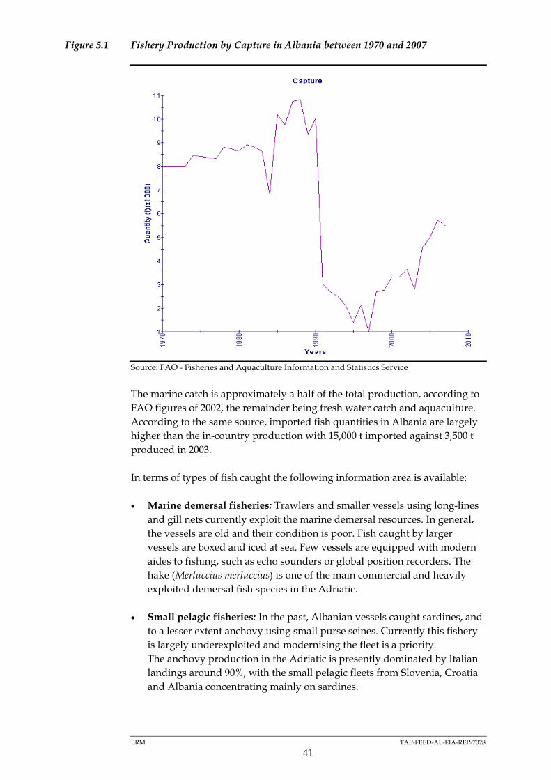
ERM TAP-FEED-AL-EIA-REP-7028
41
Figure 5.1 Fishery Production by Capture in Albania between 1970 and 2007
Source: FAO - Fisheries and Aquaculture Information and Statistics Service
The marine catch is approximately a half of the total production, according to
FAO figures of 2002, the remainder being fresh water catch and aquaculture.
According to the same source, imported fish quantities in Albania are largely
higher than the in-country production with 15,000 t imported against 3,500 t
produced in 2003.
In terms of types of fish caught the following information area is available:
Marine demersal fisheries: Trawlers and smaller vessels using long-lines
and gill nets currently exploit the marine demersal resources. In general,
the vessels are old and their condition is poor. Fish caught by larger
vessels are boxed and iced at sea. Few vessels are equipped with modern
aides to fishing, such as echo sounders or global position recorders. The
hake (Merluccius merluccius) is one of the main commercial and heavily
exploited demersal fish species in the Adriatic.
Small pelagic fisheries: In the past, Albanian vessels caught sardines, and
to a lesser extent anchovy using small purse seines. Currently this fishery
is largely underexploited and modernising the fleet is a priority.
The anchovy production in the Adriatic is presently dominated by Italian
landings around 90%, with the small pelagic fleets from Slovenia, Croatia
and Albania concentrating mainly on sardines.

ERM TAP-FEED-AL-EIA-REP-7028
42
Fishing Fleet of Albania
The distribution of the fishing fleet of Albania is in the major ports of Durres
and Vlore. The port of Durres hosts the highest number of trawlers in Albania,
with 98 registered vessels against 45 in Vlore1.
Tourism
Figures on travellers and reasons for travel provided by the national statistics
institute (Instat, Albania in Figures 2007) show that tourism is increasing. The
majority of visitors are of Albanian nationality but the number of international
visitors is also growing at a significant rate. The coast of Fier region has a
medium-high potential for tourism development. There are presently very
few marinas and touristic port structures along the coast.
Navigation and Maritime Transport
The whole of the Adriatic Sea is a public shipping zone where shipping traffic
is intense. Figure 5.2 provides and indication of the areas where shipping
traffic concentrates represented by a higher density of black lines.
Figure 5.2 Shipping Lanes in the Adriatic and Ionian Sea
Source: National Centre for Ecological Analysis and Synthesis, NCEAS
Durres is the primary harbour of Albania and is situated to the north. Durres
provides linkages with the Italian ports of Ancona, Bari, Brindisi and Trieste.
Vlore, the closest port to the south, provides linkage with the Italian ports of
Bari and Brindisi.
Ferries to the Albanian ports generally arrive in the morning and depart in the
afternoon. Between August and September, and the Christmas season are
peak periods for ferry traffic. Both freight and ferry traffic is scheduled to
(1) 1 : Ministry of Environment Forests and Water Administration, 2008

ERM TAP-FEED-AL-EIA-REP-7028
43
operate all year round, although it can be disrupted over the winter months,
particularly in November and December due to bad weather.
5.2.3 Cultural Heritage
Marine Archaeology
Linking the western Balkans and the East with Western Europe, Albanian
waters were busy with shipping since ancient and mediaeval times. The
likelihood of archaeological findings of those ages is higher in areas close to
the coast than in off-shore areas, since ships usually stayed near the shore to
maintain visual contact with land.
Given the available information on neighbouring regions specially Vlore south
of the immediate area of influence, the presence of marine archaeological
remains of the Greek, Roman and Illiryan periods, as well as remains of the 1st
and 2nd World Wars can not be discarded. There is no specific published
information about the likelihood of the presence of these remains in the area.
ERM TAP-FEED-AL-EIA-REP-7028
44
6 POTENTIAL IMPACTS AND MITIGATION MEASURES
6.1 INTRODUCTION
Tables 6.1 – 6.8 present a list of the main potential environmental,
socioeconomics and cultural heritage impacts for the onshore section (Table 6.1
– 6.6) and offshore section (Table 6.7 and 6.8) of the TAP in Albania. The tables
present the following information:
Impact Area: list of impact areas intended as the environmental,
socioeconomic and cultural heritage component potentially affected by
the project’s activities;
Potential Impacts of Significance: list of types of impact or sources of
impacts that could occur from the project on the basis of information
currently available (project and baseline). The magnitude and significance
of the impacts will need to be ascertained during the detailed impact
assessment;
Area of Influence: the geographical area which could be potentially
affected by the impact. The definition of the area of influence is to be
intended as indicative. The extent of the area of influence will need to be
ascertained during the detailed impact assessment;
Mitigation Options: list of types of mitigation and control measures that
may be considered where significant impacts are identified during the
assessment.
With regards to the Area of Influence the following criteria has been adopted:
Local – impacts that affect local environmental, socioeconomic or cultural
heritage resources or are restricted to a single habitat/biotope, a single
(local) administrative area or a single community. Although considered
local, the geographical extent of each impact within this category can be
variable, depending on the impact type and location. Local impacts may
be restricted to the Right of Way (RoW, 10-20 m wide), the working strip
(approximately 40 m wide) and areas directly affected by associated
facilities (e.g. access roads, workers camps and pipe yards), however there
will be local impacts that extend beyond but are still within the local
context (e.g. within hundreds of meters or kilometric distances from the
RoW). Orders of magnitude of distances for each local impact are
presented in the following tables.
Regional/Provincial – impacts that affect regional environmental,
socioeconomic or cultural heritage resources or are felt at a regional scale
as determined by habitat type, administrative boundaries or community.

ERM TAP-FEED-AL-EIA-REP-7028
45
Tentatively the geographical extent of regional impacts will be up to tens
of kilometres.
National – impacts that affect national environmental, socioeconomic or
cultural heritage resources or affect an area that is nationally protected/
important. Tentatively the geographical extent of national impacts will be
up to hundreds of kilometres.
Trans-boundary/International/Global – impacts that are experienced in
one country (or several countries) as a result of activities in another, which
could reach to planetary level in some occasions (e.g. global warming).
Construction, pre-commissioning, operational and decommissioning impacts
are organised according to the following impact areas:
Displacement of Land Uses, Property and People;
Resources and Waste;
Geology, Soils and Contaminated land;
The Water Environment;
Air Quality and Climatic factors;
Noise and Vibration;
Biodiversity and Nature Conservation;
Landscape and Visual Impacts;
Socio-Economic Impacts;
Community Health and Safety;
Working Conditions;
Archaeology and Built Heritage.

ERM TAP-FEED-AL-EIA-REP-7028
46
6.2 ONSHORE
6.2.1 Construction
Table 6.1 Potential Environmental Impacts and Mitigation Measures Related to Onshore Construction and Pre-Commissioning
Impact Area Potential Impact/Source Area of Influence Potential preventive/mitigation measures
Resources and waste Use of large quantities of construction material
Disposal of construction waste
Transportation of construction material and
waste
Consumption of fuel by vehicles and machinery
Sewage (black and grey water) management and
disposal
Use of water for construction activities, camps,
yards
Use of water for pre-commissioning
(hydrotesting)
Local to Regional, depending on impact
and specific location of waste disposal
sites and origin of construction material
and fuel
Materials to be sourced and disposed of with sustainable
procurement principles and from as close as possible to the
project so as to minimise impacts of production and transport.
Identify beneficial uses or opportunities for recycling
construction spoil and other wastes wherever possible.
Waste management plan and system to be implemented
Environmental and social management plan
Evaluation/assessment of water sources for hydrotesting so as
to minimise impacts to other water users and aquatic habitats
Geology, Soils and
Contaminated land Excavation works during construction including
off-site quarrying where needed (compressor
stations, block valve stations, landfall site and
tunnel)
Clearance of working strip, logistic sites (yards,
camp sites) and access roads will affect top soil
with the risk of resource loss
Physical damage through soil compaction and
accidental contamination should also be
considered (see also resources and waste).
Contaminated sediments from past activities
Local, within working strip (40 m) and
the footprint of associated facilities
(compressor and block valve stations)
Impacts from contaminated sediments
will be Local or Regional depending on
the location of the waste disposal sites
Construction site management plan
Preservation of topsoil
Reinstatement of topsoil following completion of construction
activities
Oil & Chemicals Spill Contingency Prevention & Planning
Detailed route investigations to avoid contaminated areas

ERM TAP-FEED-AL-EIA-REP-7028
47
Impact Area Potential Impact/Source Area of Influence Potential preventive/mitigation measures
Impacts to aquatic habitats, water quality & river
morphology from river crossings of the right of
way and access roads
Impacts to river morphology will be
local and typically within the working
strip (40 m). Impacts to water quality
will depend on the river/channel to be
crossed but could be up to hundreds of
meters upstream of the crossing (e.g. in
tidal rivers/channels) and between
hundreds of meters and a kilometre
downstream. Same would apply to
river crossings of new access roads.
Minimise number of river crossings
Select crossing locations in order to minimise impacts to
riparian vegetation and to the river channel and habitat
Select working window to minimise impacts on aquatic species
(winter)
Monitoring of water quality – Environmental Monitoring Plan
Reinstate channel, banks and riparian vegetation to pre-
construction status
Audit management and reinstatement
Alternative construction techniques to open cut trenching and
backfilling (e.g. Horizontal Directional Drilling)
Sediment plumes from working strip, yards,
camps and access roads due to rainwater runoff
Local, specific distances depend on
local conditions. Could be up to a
kilometre downstream of the discharge
location
Management of working strip, access roads, yards and camps
to minimise sediment runoff into water courses (silt fences, silt
traps, vegetation of stockpiles and of marginal areas, etc.)
Monitoring of water courses/water bodies - Environmental
Monitoring Plan
Oil & chemical contamination from machinery
on working strip, yards, camps and access roads
Local, typically within working strip
(40 m). Specific distances depend on
local conditions. Could be up to a
kilometre downstream of the accidental
release.
Fuelling/bunkering procedure for machinery, generators, etc.
Bunded or contained oil/fuel storages
Oil & Chemicals Spill Contingency Prevention & Planning
Chemical handling procedures
Oil & Chemical spill response kit on sites
HSE Training of all on-site personnel on environmental
awareness (including managing erosion and siltation on site
and waste management) and oil & chemical spill prevention
and response. This mitigation measure is valid for all impacts.
Water Environment
Generation of waste water and solid waste (from
camps, working strip)
Local, specific distances depend on
local conditions. Could be up to a
kilometre downstream of the discharge
location
Treatment of waste water prior to discharge in any water body
Locate yards and camps away from water courses/water
bodies
Waste management plan

ERM TAP-FEED-AL-EIA-REP-7028
48
Impact Area Potential Impact/Source Area of Influence Potential preventive/mitigation measures
Impacts from discharge of aqueous effluents
derived from the tunnel construction (e.g. slurry
from tunnel boring activities – depending on
method selected) and hydrotesting
Local, between hundreds of meters and
a kilometre downstream. Specific
distances depend on local conditions.
Management of aqueous effluents on site (on-site collection
and treatment of effluents prior to discharge into water courses
and water bodies).
Waste management plan
Monitoring of water courses/water bodies - Environmental
Monitoring Plan
Evaluation/assessment of water sources and discharge
locations
Impacts from dust generated from earth
movements, excavation, vehicles movement,
stockpiles, unpaved surfaces, etc. along the
working strip, access roads, yards and camps.
Receptors will include residential population,
workers, fauna and flora species, cultural,
historic, water quality, etc.
Local, typically vicinity of working
strip of pipeline (within 100 m) and
associated facilities (new roads, yards,
camps). Specific distances depend on
local conditions and could be up to
hundreds of metres in certain
unfavourable meteorological situations
Good construction site management practices such as covering
of loose materials, vehicle speed limits, watering dusty
surfaces in dry weather, sheeting of trucks, etc.
Environmental and social management plan
Air Quality and Climatic
factors
Impacts from emissions to the atmosphere from
machinery and vehicles (i.e. generators,
excavators, bulldozers, side booms, trucks, cars,
compressors for hydrotesting etc.). Receptors
will include residential population, workers,
fauna and flora species, water quality, etc.
Local, typically vicinity of working
strip of pipeline (within 100 m) and up
to hundreds of meters. Specific
distances depend on local conditions.
Global - Greenhouse gases (e.g. CO2)
Maintenance of equipment and vehicles
Routing of construction traffic away from sensitive areas
Training of operators and drivers
Avoiding construction traffic from crossing densely populated
areas or historic centres
Traffic management plan
Use of low sulphur fuels if available
Modelling of pollutant dispersion from main emission sources
(generators, compressors)
Monitoring of main emission sources (generators,
compressors) - Environmental Monitoring Plan
Environmental and social management plan.

ERM TAP-FEED-AL-EIA-REP-7028
49
Impact Area Potential Impact/Source Area of Influence Potential preventive/mitigation measures
Noise and Vibration Impacts from noise and vibration from
machinery, construction vehicles, blasting of
rocks (if required) and compressors for
hydrotesting. Noise receptors will include
residential population (and sensitive receptors
like schools and hospitals), workers, fauna,
cultural/historical buildings, etc.)
Local, specific distances depend on
local conditions and source:
o Machinery and construction
vehicles. Typically between working
strip (40 m) and up to hundreds of
meters.
o Blasting. Up to 10 km
Good construction site management
Limiting working hours close to sensitive receptors
Using specific mitigation on noisy equipment (acoustic
shielding)
Locating noisy equipment (e.g. generators, compressors) away
from noise sensitive receptors
Speed limits for vehicles
Adequate Personal Protective Equipment (PPE) for workers
Modelling of main noise emission sources (generators,
compressors)
Monitoring of main emission sources (generators,
compressors) - Environmental Monitoring Plan
Environmental and social management plan.
Biodiversity and Natural
HabitatsImpacts from habitat loss. The impacts will be
both temporary and long term/permanent.
Temporary impacts will arise from the working
strip, camps and yards which will be reinstated
to pre-construction conditions once construction
is completed.
Local, working strip (40 m) and
footprint of associated facilities
Route and associated infrastructure location selection
Alternative construction techniques to open cut trenching and
backfilling (e.g. Horizontal Directional Drilling)
Minimise footprint wherever possible (e.g. narrower working
strip)
Restore pre-construction conditions as far as possible (e.g. re-
vegetation of working strip) - Vegetation/Landscape
Restoration Plan.

ERM TAP-FEED-AL-EIA-REP-7028
50
Impact Area Potential Impact/Source Area of Influence Potential preventive/mitigation measures
Impacts to fauna and flora species of nature
conservation interest from the project’s activities
(e.g. noise, aqueous discharges, sediments
plumes, uptake of water for hydrotesting,
greater human pressure to previously
inaccessible areas) during construction and pre-
commissioning works with particular reference
to sensitive areas such as nesting places, old
growth forests, wetlands, rivers, riparian
vegetation and areas identified as rich in
endemic and protected species.
Local, specific distances depend on
source of impact and local conditions.
Typically immediate vicinity of
working strip of pipeline (40 m) and
associated facilities (new roads, yards,
camps). Specific distances depend on
local conditions and could be up to
hundreds of metres in certain
unfavourable conditions. Impacts to
water quality and aquatic habitats
could be up to a kilometre depending
on the impact and the conditions.
As above for water quality, air quality noise & vibration
impacts
Management of dust, air emissions, aqueous discharges and
waste to minimise impacts on flora, fauna and ecosystems (e.g.
locating fixed machinery as far as possible from sensitive
habitats)
Restrict construction during certain periods/seasons at certain
areas
Monitor impacts on flora and fauna at sensitive locations -
Environmental Monitoring Plan
Environmental and Social Management Plan
Biodiversity Action Plan (BAP) to be designed for the life of the
project. Action Plans for specific important species (e.g. bear)
and habitats/environments should be developed.
Relocate endemic/rare plant species to suitable nearby habitats
Landscape and Visual
Impacts Temporary and permanent landscape and visual
impacts from land take and above-ground
structures. The impacts will be temporary for the
working strip, camps and yards which will be
reinstated to pre-construction conditions once
construction is completed. Sections with
potentially significant landscape impacts include
mountain ridges or elevated terrain and old
growth and mature forests.
Local, specific distances depend on
local conditions. Up to 10 km in certain
circumstances (Regional)
Minimise footprint wherever possible (e.g. narrower working
strip)
Restore pre-construction conditions as far as possible (e.g. re-
vegetation of working strip) - Vegetation/Landscape
Restoration Plan.
Visual mitigation measures where deemed necessary
(compressor stations)
Location of new roads, temporary accesses and camps away
from sensitive landscape locations

ERM TAP-FEED-AL-EIA-REP-7028
51
Table 6.2 Potential Socioeconomic Impacts and Mitigation Measures related to Onshore Construction and Pre-Commissioning
Impact Area Potential Impact/Source Area of Influence Potential preventive/mitigation measures
Displacement of Existing
Land Uses, Property and
People
Temporary impacts on land uses. Temporary
impacts will arise from the working strip which
will be re-instated following the completion of
the construction activities returning the land to
its original use. Impacts on annual crops will
also be temporary along the working strip along
which annual crops can be grown once re-
instated.
Local, working strip of pipeline (40 m)
and associated facilities (new roads,
yards, camps) and areas to be occupied
by compressor stations, block valve
stations and associated permanent
facilities.
Implement a Resettlement Action Plan (RAP) to set out how
resettlement for permanent and temporary acquisition of land
will be managed and mitigated in line with TAP’s Strategy for
the Acquisition of Land and Easement.
Implement a land restoration plans to ensure previous use and
users returning on completion of construction.
Increased government revenues (e.g. permit &
construction fees and levies)
Local, Regional and National, Early engagement with national government stakeholders
Impacts to local livelihoods and loss of
household income as a result of construction
works (e.g. temporary and long term occupation
of agricultural land).
Site clearing and opening of access roads in
mountainous areas could affect the collection of
forest products and animal grazing.
Local, working strip of pipeline (40 m)
and associated facilities (new roads,
yards, camps) and areas to be occupied
by compressor stations, block valve
stations and associated permanent
facilities. Land plots and areas affected
by decreased accessibility due to the
presence of construction sites.
Ensure that the Resettlement Action Plan (RAP) includes a
strategy for land acquisition based on compensation for loss of
livelihoods (i.e. Livelihoods Restoration Plan) as stated in
TAP’s Strategy for the Acquisition of Land and Easement.
Community Engagement Plan (CEP) as part of TAP
stakeholder engagement strategy.
Engage a team of Community Liaison Officers (CLOs) to
manage and monitor TAP’s community relations.
Socio-Economic Impacts
Economic benefits to households and to the local
economy as a result of direct/indirect job
creation during construction works.
Benefit to the local community and economy as a
result of local procurement of materials for
construction and other services to supply the
project.
Local and Regional (communes and
districts) benefitting from employment
and procurement opportunities.
Develop an Employment and Procurement Strategy to ensure
maximisation of opportunities for local people and businesses.
Maximise local employment during construction and provide a
fair and transparent recruitment process and to enhance local
skills base through training provided by TAP
As far as possible, procure goods from local suppliers through
sub-contracts to local firms (subject to availability, quality and
cost) and purchasing of goods from local retailers (TBC).

ERM TAP-FEED-AL-EIA-REP-7028
52
Impact Area Potential Impact/Source Area of Influence Potential preventive/mitigation measures
The presence of workers on the site during
construction works could have an impact on
social infrastructures (water, electricity, roads,
health centres)
While there might be a temporary pressure on
these infrastructures in the short term, there may
be also a positive impact on infrastructure
development in the medium to long term.
Local, typically vicinity of working strip
of pipeline (40 m) and associated
facilities (new roads, yards, camps) and
areas around compressor stations, bock
valve stations and associated facilities.
Ensure provision of social infrastructure to workforce.
Facilitate access of local communities to new infrastructures, in
particular new access roads.
The presence of workers on the site and the
money they earn and spend may cause changes
to local customs and norms.
Impacts on local livelihoods (e.g. farming and
herding) from project construction could also
impact on social institutions and cohesion of the
local community since livelihoods and social
institutions are often closely bound with each
other.
Local, typically vicinity of working strip
of pipeline (40 m) and associated
facilities (new roads, yards, camps) and
areas around compressor stations, bock
valve stations and associated facilities
Implementation of a Community Engagement Plan (CEP) as
part of TAP stakeholder engagement strategy.
Engage a team of Community Liaison Officers (CLOs) to
manage and monitor the satisfactory implementation on
effectiveness of all community relation procedures.
Develop a Workers Code of Conduct that will include
disciplinary measures for those that break the Code
requirements.
Safety risks for communities as a result of
construction works.
Increased traffic loads on roads adjacent to the
project
Local, communities currently using and
living along the roads to be transited by
the project’s vehicles, including
mountain roads. Communities along
transportation routes
Develop a community Safety Management Plan to address
safety risks for communities, including traffic related risks.
Provide traffic awareness training at local schools and at
community level to raise the awareness of communities
regarding avoidance of road related accidents.
Community Health and
Safety
The project has the potential to impact on
neighbouring communities through changes in
noise and air quality, water quality, water
resources, visual impact and changes in
accessibility (see above), but also by causing
severance between people’s homes and places
they want to visit or go to work to (such as
agricultural land and grazing areas).
Local, communities located in the
vicinity of construction sites (up to 10
km in certain circumstances)
Impacts of severance will be mitigated by provision of
replacement crossing points.
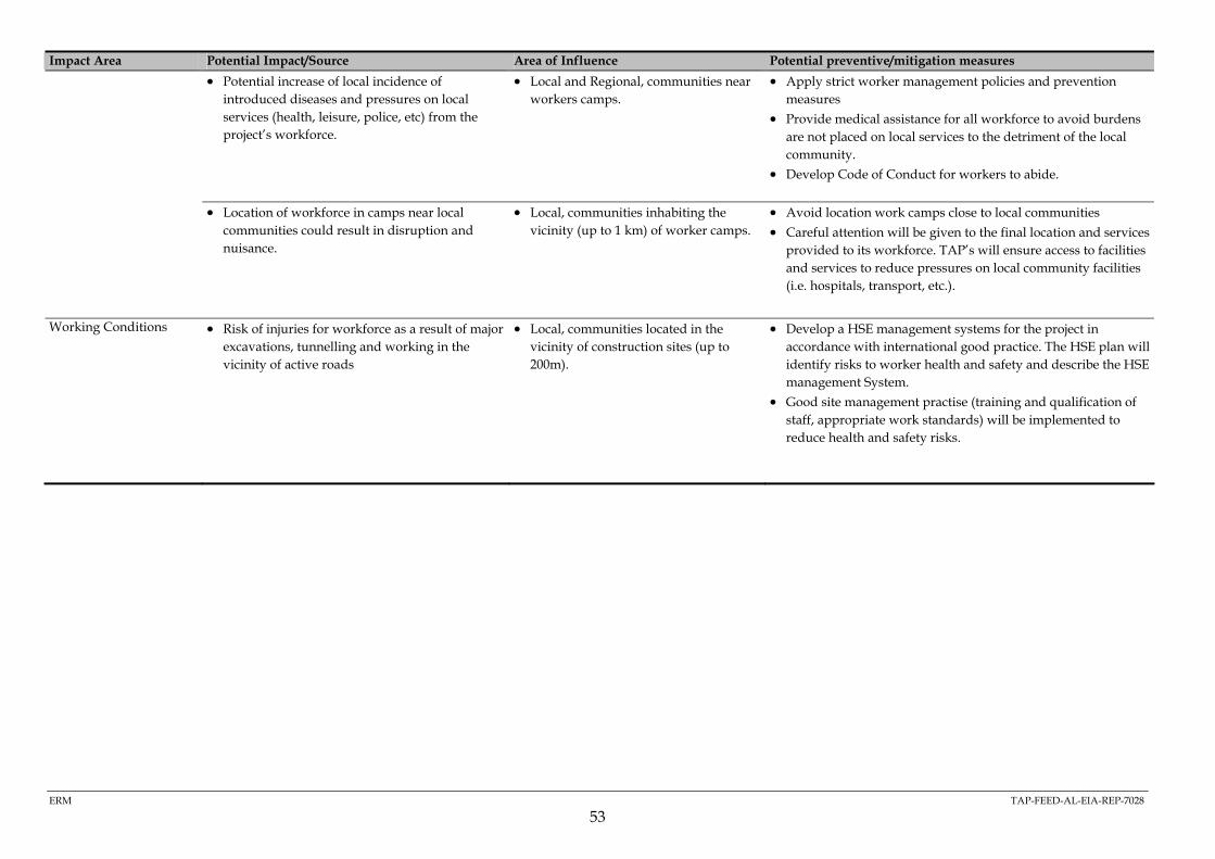
ERM TAP-FEED-AL-EIA-REP-7028
53
Impact Area Potential Impact/Source Area of Influence Potential preventive/mitigation measures
Potential increase of local incidence of
introduced diseases and pressures on local
services (health, leisure, police, etc) from the
project’s workforce.
Local and Regional, communities near
workers camps.
Apply strict worker management policies and prevention
measures
Provide medical assistance for all workforce to avoid burdens
are not placed on local services to the detriment of the local
community.
Develop Code of Conduct for workers to abide.
Location of workforce in camps near local
communities could result in disruption and
nuisance.
Local, communities inhabiting the
vicinity (up to 1 km) of worker camps.
Avoid location work camps close to local communities
Careful attention will be given to the final location and services
provided to its workforce. TAP’s will ensure access to facilities
and services to reduce pressures on local community facilities
(i.e. hospitals, transport, etc.).
Working Conditions Risk of injuries for workforce as a result of major
excavations, tunnelling and working in the
vicinity of active roads
Local, communities located in the
vicinity of construction sites (up to
200m).
Develop a HSE management systems for the project in
accordance with international good practice. The HSE plan will
identify risks to worker health and safety and describe the HSE
management System.
Good site management practise (training and qualification of
staff, appropriate work standards) will be implemented to
reduce health and safety risks.

ERM TAP-FEED-AL-EIA-REP-7028
54
Table 6.3 Potential Cultural Heritage Impacts and Mitigation Measures related to Onshore Construction and Pre-Commissioning
Impact Area Potential Impact/Source Area of influence Potential
preventive/mitigation
measures
Archaeology (known and
potential) and Built
Heritage including
“intangible cultural
heritage” (ICH)
Ground disturbing construction activities
including permanent and temporary
occupations (i.e. working strip, compressor
stations, pipe yards, workforce camps, tunnel
portals, landfills/land takes and accesses).
Local, working strip of pipeline (40 m) and
associated facilities (new roads, yards,
camps) and areas to be occupied by
compressor stations, block valve stations
and associated permanent facilities.
Cultural Heritage Management Plan (including ICH):
Detailed reconnaissance survey of known monuments, ICH
and archaeological sites.
Implementation of archaeological monitoring and a “chance
finds” procedure with special focus on high potential
archaeological areas.
Avoidance of certain and likely impacts by project redesign for
archaeological site, monuments and ICH.
Use of low special impact construction techniques where
complete avoidance (e.g. re-routing) is not feasible.
Removal of resources by rescue excavations and associated
studies.
ESMP within the ESIA to outline the Cultural Heritage
Management Plan.

ERM TAP-FEED-AL-EIA-REP-7028
55
6.2.2 Operation
Table 6.4 Potential Environmental Impacts and Mitigation Measures related to Onshore Operation
Impact Area Potential Impact/Source Area of influence Potential preventive/mitigation measures
Resources and waste Waste and wastewater generated by stations
during maintenance. This includes waste
generated by pigging operations (tailings,
sludge).
Local, specific distances depend on local
conditions
Waste management plan
Air Quality and Climatic
factorsImpacts from air emissions from the
compressor station (turbines)
Non-routine events such as emergency
venting (and depressurisations for
maintenance) at the compressor station or
pipe failure have a higher potential to reduce
air quality.
Local, specific distances depend on local
conditions, typically hundreds of meters,
but could be up to a kilometre in certain
unfavourable meteorological conditions.
Greenhouse gases, Global
Maintenance and monitoring
Air quality monitoring
Location of compressor station away from sensitive receivers
Adoption of Best Available Techniques (BAT) for the
abatement of air pollutants
Noise and Vibration Impacts from noise emissions during the
normal operation of the compressor stations
(e.g. compressors, turbine engines). Non-
routine events such as emergency venting.
Noise receptors will include residential
population (and sensitive receptors like
schools and hospitals), workers, fauna,
cultural/historical buildings, etc.
Local, specific distances depend on source
of impact, local conditions, and location of
sensitive receptors.
Compressor noise from 200 m to more than
a kilometre in certain unfavourable
meteorological conditions.. Over a
kilometre for noise generated during
emergency venting (typically for short
periods of time).
Maintenance and monitoring
Noise emission monitoring
Location of compressor station away from sensitive receivers
Modelling of main noise emission sources (generators,
compressors)
Monitoring of main emission sources (generators,
compressors) - Environmental Monitoring Plan
Using specific mitigation on noisy equipment (acoustic
shielding)
Locating noisy equipment (compressors) away from noise
sensitive receptors

ERM TAP-FEED-AL-EIA-REP-7028
56
Impact Area Potential Impact/Source Area of influence Potential preventive/mitigation measures
Biodiversity and Nature
Conservation Impact to fauna from the noise emissions
from the compressor stations
Impacts to flora and fauna from the routine
maintenance/clearance of the inner safety
corridor (maximum 10 m wide) where no
deep routed vegetation will be allowed to
avoid interference with pipeline.
Local, RoW (20 m) from 200 m to more than
a kilometre in certain unfavourable
meteorological conditions in the
surroundings of the compressor stations.
Noise emissions, as above
Restore pre-construction conditions as far as possible (e.g. re-
vegetation of working strip) and maintain vegetation -
Vegetation/Landscape Restoration Plan.
Monitor impacts on flora and fauna at sensitive locations
Environmental and Social Management Plan
Biodiversity Action Plan (BAP) to be designed for the life of
the project. Action Plans for specific important species (e.g.
bear) and habitats/environments to be developed.
Landscape and Visual
Impacts Impacts to landscape due to permanent land
take for the compressor stations and block
valve stations.
Impacts to landscape from routine
maintenance of the RoW.
Local, RoW (20 m) and accesses for
maintenance clearance, other specific
distances in terms of the permanent
structures (block valve and compressor
stations) depend on local conditions
See above
The Vegetation/Landscape Restoration Plan should pose
special attention to areas with high visibility or where special
re-vegetation techniques should be established (e.g. slope
stabilisation techniques on mountain slopes).
Table 6.5 Potential Socioeconomic Impacts and Mitigation Measures related to Onshore Operation
Impact Area Potential Impact/Source Area of Influence Potential preventive/mitigation measures
Displacement of Existing
Land Uses, Property and
People
Permanent land acquisition/easement
during operation
Permanent changes to land uses in particular
agricultural land for permanent crop
production (e.g. olive trees, fruit orchards,
vineyards).
Local, RoW (20 m) and areas to be occupied
by compressor stations and other
permanent infrastructures.
Develop a Resettlement/Livelihood Restoration Action Plan
setting out how resettlement for permanent and temporary
acquisition/easement of land will be managed and mitigated
during operation and decommissioning.
Implement a land restoration plans to ensure previous use
and users returning after decommissioning of the project.
Develop a Community Engagement Plan (CEP) as part of
TAP stakeholder engagement strategy.
Engage a team of Community Liaison Officers (CLOs) to
manage and monitor TAP’s community relations and
restoration plans

ERM TAP-FEED-AL-EIA-REP-7028
57
Impact Area Potential Impact/Source Area of Influence Potential preventive/mitigation measures
Increased government revenues as a result of
tariffs on gas transport.
National, RegionalSocio-Economic Impacts
Economic benefits to households and to the
local economy as a result of direct/indirect
job creation during operation (e.g.
compressors stations).
Local and regional (provincial, communes
and districts) benefitting from employment
and procurement opportunities.
Develop an Employment and Procurement Strategy to ensure
maximisation of opportunities for local people and
businesses.
Maximise local employment during operation and provide a
fair and transparent recruitment process and to enhance local
skills base through training provided by TAP
As far as possible, procure goods from local suppliers
through sub-contracts to local firms (subject to availability,
quality and cost) and purchasing of goods from local
retailers.
Land use restriction for safety reasons (built
permanent and semi permanent , such as
greenhouses, infrastructures)
To assure the integrity of the pipeline, the
construction of houses will be restricted in
a corridor of maximum 60 m and the
establishment of cluster of houses and/or
industrial infrastructure in a corridor of
maximum 200 m
The preferred route was selected to accommodate the safety
criteria (see area of influence) and allows sufficient space also
for future developments of neighbouring communities
Community Health and
SafetySafety risks for communities as a result of
project operation activities, in particular
those related to traffic operations.
Local, communities currently using and
living along the roads to be transited by the
project vehicles, including mountain roads.
Communities along transportation routes
Develop a Community Safety Management Plan to address
safety risks for communities, including traffic related risks.

ERM TAP-FEED-AL-EIA-REP-7028
58
Impact Area Potential Impact/Source Area of Influence Potential preventive/mitigation measures
The project has the potential to impact on
neighbouring communities through changes
in noise and air quality, visual impact and
changes in accessibility (see above), but also
by causing severance between people’s
homes and places they want to visit or go to
work to (such as agricultural land and
grazing areas).
Local, communities Impacts of severance will be mitigated by provision of
replacement crossing points.
Working Conditions Risk of injuries for workforce as a result of
routine project operation activities like
maintenance
Local, communities currently using and
living along the roads to be transited by the
project vehicles, including mountain roads.
Develop a HSE management systems for the project in
accordance with international good practice. The HSE plan
will identify risks to worker health and safety and describe
the HSE management System.
Good site management practice (training and qualification of
staff, appropriate work standards) will be implemented to
reduce health and safety risks.
Table 6.6 Potential Cultural Heritage Impacts and Mitigation Measures related to Onshore Operation and Decommissioning
Impact Area Potential Impact/Source Area of influence Potential preventive/mitigation measures
Archaeology (known and
potential) and Built
Heritage including
“intangible cultural
heritage” (ICH)
No specific impacts or risks are expected
during the operation (land take and earth
works limited to construction phase)
Ground disturbing removal and restoration
activities during decommissioning
Local, RoW (20 m) footprint of associated
decommissioning activities
Cultural Heritage Management Plan (including ICH)

ERM TAP-FEED-AL-EIA-REP-7028
59
6.3 OFFSHORE
Table 6.7 Potential Environmental, Socioeconomic and Cultural Heritage Impacts and Mitigation Measures related to Offshore Construction
Impact Area Potential Impact/Source Area of influence Potential preventive/mitigation measures
Resources and waste Consumption of fuel by vessels and
machinery
Sewage (black and grey water) management
and disposal.
Solid waste production and disposal.
Local to National, depending on impact
and specific location of waste disposal and
origin of construction material and fuel, for
example
Operation under international standards (MARPOL)
Maintenance and monitoring
Waste management plans
Seabed Temporary and permanent alteration of the
seabed in areas where trenching or other
intervention works may be required.
Local, footprint of intervention works,
typically up to 40 m.
Routing of the pipeline.
Design and construction management to minimise alteration
Water Quality Sediment plumes (potentially including
contaminants) causing smothering or other
detrimental effects to benthos and fish.
Vessel operations wastewater discharges
Disposal of the water from hydro-testing
Potential oil spills and leaks form machinery
and vessels.
Local, specific distances depend on local
conditions. Typically hundreds of meters
but could be up to several kilometres as a
result of certain unfavourable metocean
conditions (e.g. strong currents)
Operation under international standards (MARPOL)
Bunkering procedures
Oil & Chemicals Spill Contingency Prevention & Planning
Design and construction management
Technical solutions to minimise sediment plumes e.g. closed
buckets for backhoe dredgers, silt screens (if necessary)
Use of untreated water for hydro-testing
Use of diffusers for hydro-testing discharge
Air Quality and Climatic
factorsExhaust fumes from vessel and machinery. Local, specific distances depend on local
conditions, typically hundreds of meters,
but could be up to a kilometre in certain
unfavourable meteorological conditions.
Greenhouse gases, Global
Maintenance and monitoring

ERM TAP-FEED-AL-EIA-REP-7028
60
Impact Area Potential Impact/Source Area of influence Potential preventive/mitigation measures
Biodiversity and Nature
Conservation Direct effects on coastal/benthic/intertidal
communities/habitats along the pipeline
route and landfall during construction (e.g.
dredging, trenching, pipe lay, excavation, use
of barges and anchors).
Indirect effects of suspended sediments
(smothering, reduced penetration of light)
and hydro-testing/wastewater discharges
Disturbance to coastal fauna (birds)
Subsea noise generation.
Accidental releases of chemicals, fuel
Alien invasive species from construction
vessels (e.g. introduced through the release
of ballast water)
Local, footprint of intervention works ,
other specific distances depend on source
of impacts and local conditions:
Suspended sediment plume,
discharge of hydrotest water:
Typically, tens to hundreds of
meters. In certain temporary
unfavourable metocean conditions,
could reach up to several kilometres;
Underwater noise effects on fauna.
Variable distance depending on
sources (e.g. type of vessel/activity),
species and location. Typically, tens
to hundreds of meters, but in certain
temporary unfavourable conditions,
could reach up to several kilometres
for some especially sensitive species.
Avoidance of sensitive marine habitats (e.g. local re-routes)
Oil & Chemicals Spill Contingency Prevention & Planning
Design and construction management
Technical solutions to minimise sediment plumes e.g. closed
buckets for backhoe dredgers, silt screens (if necessary)
Use of untreated water for hydro-testing
Use of diffusers for hydro-testing discharge
Evaluation/assessment of hydrotest water discharge location
Seasonal timing of works.
Operation under international standards (MARPOL)
Socio-Economic and
community Health and
Safety Impacts
Increased government revenues as a result of
tariffs on transport.
Temporary disruption to vessel traffic.
Temporary limiting access to commercial
fishermen.
Potential risk of collision with other sea
users, or interference with other users which
can involve safety issues.
Temporary disruption of tourism activities
Indirect effects from construction activities
(see onshore)
Local to National, depending on origin of potentially impacted element
Where feasible minimise impacts to fishing/shipping areas through local re-routing
Information to authorities/fishermen/mariners. Navigational warnings
Lights, radio communications and other safety devices.
Stakeholders engagement, potential compensation.

ERM TAP-FEED-AL-EIA-REP-7028
61
Impact Area Potential Impact/Source Area of influence Potential preventive/mitigation measures
Archaeology and Built
HeritageDirect physical damage, e.g. from pipe
laying, excavation, anchoring or dredging;
Indirect effects (e.g. through rock placement
or dredging respectively), leading to
deterioration, loss, or loss of access to,
cultural heritage.
Local, footprint of intervention, other
specific distances depend on local
conditions, typically not more than
hundreds of meters
Cultural Heritage Management Plan (including ICH):
Detailed route survey
Implementation of archaeological monitoring and a “chance
finds” procedure
Use of low special impact construction techniques where
complete avoidance (e.g. re-routing) is not feasible.
Removal of resources by rescue excavations and associated
studies.
ESMP within the ESIA to outline the Cultural Heritage
Management Plan.
Table 6.8 Potential Environmental, Socioeconomic and Cultural Heritage Impacts and Mitigation Measures Related to Offshore Operation
Impact Area Potential Impact/Source Area of influence Potential preventive/mitigation measures
Resources and waste,
water quality Solid waste production and disposal
(pipeline maintenance activities).
Local to National, depending on impact
and specific location of waste disposal
Maintenance and monitoring
Waste management plans
Biodiversity and Nature
Conservation Modification of hydrodynamics, with
subsequent effects on seabed features and
distribution and abundance of organisms,
Introduction of permanent artificial substrate
(e.g. pipeline, seabed tie-in facilities, rock
armour, concrete mattresing) on the seabed,
leading to colonisation by epifauna
(including the potential for invasive species).
Local, specific distances depend on local
conditions, typically within tens of metres
from pipeline
Maintenance and monitoring
Waste management plans
Socio-Economic and
community Health and
Safety Impacts
Interaction with fishing gear and risk to
fishing vessels if pipeline becomes exposed
or spans develop in the pipeline;
Vessel anchor impact, emergency anchoring
or dragged anchoring in the vicinity of the
pipeline.
Local to National or International
depending on origin of fishing vessel
Monitoring/surveillance of pipe
Agreements for proven damage compensation

ERM TAP-FEED-AL-EIA-REP-7028
62
Impact Area Potential Impact/Source Area of influence Potential preventive/mitigation measures
Pipeline
integrity/GeohazardsSeismic activity, faults, slope instability,
which constitute a menace for the pipeline
integrity.
Local or Regional, depending on the extent
of the event
Safety design studies.
Route refining (during routing phase)
Archaeology and Built
HeritageModification of hydrodynamics, with
subsequent effects on seabed features
scouring, exposure and deterioration of
archaeological resources such as wrecks.
Local, specific distances depend on local
conditions, , typically not more than
hundreds of metres
Routing, salvage

ERM TAP-FEED-AL-EIA-REP-7028
63
6.4 MAIN FINDINGS OF PRELIMINARY ASSESSMENT
The preliminary assessment presented in the tables above has been based on
the project information currently available, the baseline information collected
to date and the experience gained in similar projects constructed in similar
environmental and socioeconomic contexts.
The likelihood, magnitude and significance of the impacts will be further
assessed in the detailed ESIA. However the preliminary assessment highlights
that construction impacts of a pipeline and associated facilities are typically
temporary in nature and localised. These include temporary noise and air
emissions from construction machinery, impacts on land use,
loss/disturbance of natural habitats (flora and fauna), landscape and
temporary impacts to water quality and aquatic habitats during river
crossings and near shore marine works. The magnitude and significance of
construction impacts will depend on the local conditions. Typically
construction impacts can be managed and mitigated efficiently.
The onshore pipeline will be buried and the land will be re-instated to its pre-
construction status. The main limitations on land use above the pipeline will
be a narrow corridor of maximum 10 m in which the growing of deep routing
trees will be restricted, a corridor of maximum 60 m in which the construction
of houses will be restricted and a corridor of maximum 200 m in which the
establishment of cluster of houses and/or industrial infrastructure is limited.
The preferred route was selected to accommodate this criteria and allows
sufficient space also for future developments of neighbouring communities.
The operation of the compressor stations will generate air emissions and noise
and will have an impact on the landscape. The magnitude and significance of
these impacts are comparable to those of small co-generation gas power
plants. Best practice and mitigation measures will be adopted to minimise
operational impacts. Landscape impacts will be managed through the
restoration of the original landscape along the pipeline route and through
vegetation screening of the permanent structures where required.

ERM TAP-FEED-AL-EIA-REP-7028
64
7 TERMS OF REFERENCE FOR ESIA
7.1 INTRODUCTION
A key outcome of the scoping process is the definition of the Terms of
Reference (or ToR) of the detailed ESIA study. The findings of the ESIA study
will presented in an ESIA report (or EIA report in line with Albanian
Regulations) which will be prepared in compliance with National Albanian
standards and regulations as well as international standards. As for all
previous ESIA steps performed by TAP (Alternative Routes Assessment and
Scoping) TAP has selected the more stringent EBRD standards as the
international standards benchmark for the ESIA report.
The following sections present the Terms of Reference of the detailed ESIA
which will be performed for TAP. The section is structured as follows:
Overview of activities to complete the ESIA process;
Specialist studies;
Stakeholder engagement;
Outline structure for the final ESIA report; and
Provisional schedule for the ESIA process.
7.2 ESIA OBJECTIVES
TAP recognises that comprehensive planning and management of
environmental and socio-economic issues are essential to the execution of any
successful project and, therefore, intends to fully integrate environmental and
socio-economic considerations into the life cycle of the proposed Project.
To support this, TAP will commission a detailed, integrated Environmental
and Social Impact Assessment (hereafter referred as an ESIA) to be conducted
in accordance with the following Albanian requirements:
Law No. 8990 on Environmental Impact Assessment (January 23, 2003)
In addition, the ESIA will be prepared in line with the EBRD’s Environmental
and Social Policy (2008) including Performance Requirements (PR).
The purpose of the ESIA is to assess the potential impacts of the project and
project-related activities on the environment (including biophysical and socio-
economic resources) and, where applicable, to design mitigation or
enhancement measures to avoid, remove or reduce negative impacts to the
environment.

ERM TAP-FEED-AL-EIA-REP-7028
65
7.3 ESIA STEPS
Following on from the scoping phase of the project, the ESIA will:
Update and finalise the technical project description as further
engineering details become available, working closely with project
engineers to confirm details such as the final layout of associated facilities
(in particular compressor stations and block valve stations), final locations
and layout of temporary infrastructures (pipe yards and worker camps),
and construction and operation plans;
Conduct additional consultation and further refine the scope of the ESIA
as necessary;
Collect additional baseline data through desktop research and field
studies to complete a comprehensive description of the environmental,
social and cultural heritage conditions;
Develop mitigation and enhancement measures and outline an
Environmental and Social Management Plan (ESMP) including an
approach for monitoring;
Report findings in a comprehensive ESIA report.
7.4 SPECIALIST STUDIES
To develop a complete understanding of the existing environmental, social
and cultural heritage conditions (resources and receptors) in the project area
of influence, further desktop, bibliographic and field studies will be carried
out as summarised Appendix D. Any modeling studies required for the
assessment of impacts in the ESIA and an outline of an approximate
timeframe of the activities is also reported in Appendix D.
7.4.1 Desktop Studies
Desktop studies will include additional research to identify existing
documentation that contains information relevant to key resources present in
the project environment. Potential sources include publicly available
literature with relevance to the project site and general area.
Finally, project engineering studies will be reviewed for quantitative
information on environmental elements. Studies that may provide useful data
would include geotechnical investigations, bathymetric and seabed
investigations, process and operations water source investigations, surface
water drainage studies, air emission studies and any other studies of
relevance.
7.4.2 Field Studies
Planned Studies
Primary data will be collected by field studies carried out by environmental,
socio-economic and cultural heritage specialists. Specialist with qualifications
in the particular resource area and knowledgeable of the local conditions will
ERM TAP-FEED-AL-EIA-REP-7028
66
be used. International specialists will be used to provide technical guidance
and quality assurance.
Determination of Seasonal Variations
For the TAP project primary sampling will be conducted between spring and
summer. Within this timeframe, for any particular resource, selection of the
specific sampling period will consider:
when sampling will be most representative of the existing conditions;
when ‘worst case’ conditions exist (e.g. when noise levels are the lowest,
when traffic levels are the heaviest); and
if seasonal variations would have significant effect on determination of
potential impacts and significance
Where relevant and necessary, specific autumn surveys will also be conducted
and incorporated in the final version of the ESIA
The specialists will adopt scientifically accredited and recognised sampling
methodologies.
7.5 STAKEHOLDER ENGAGEMENT
Having completed initial scoping consultation and disclosure, the subsequent
steps will be undertaken:
Baseline consultation;
ESIA report disclosure and consultation.
7.5.1 Baseline Consultation
Engagement activities carried out later on in the ESIA Study stage include
consultations designed to inform local stakeholders about project design, to
obtain their key concerns and high level issues and to inform the development
of mitigation for the project. This consultation will enable the ESIA team to
refine the ESIA analysis by generating additional feedback on the ESIA
approach, key issues and analysis of potential impacts (such as assessment of
their relative significance).
Consultation will be carried out with local community leaders and small
groups of key stakeholders in the communities, the land of which is located
within the 2 km study corridor. These will be undertaken alongside the social
baseline study that will be carried out to better understand these stakeholders.

ERM TAP-FEED-AL-EIA-REP-7028
67
7.5.2 ESIA Report Disclosure and Consultation
The draft ESIA will be publicly disclosed and comments and suggestions will
be collected from stakeholders and the public. The disclosure and consultation
will be organised at national, regional and local level under the supervision of
the Ministry of Environment Forests and Water Administration and the
Regional Environmental Agencies. All administrative levels from the region to
the communes and village representatives will be invited to engage as well as
the local communities, NGOs and other interested parties.
The notification of the public hearings will be announced through media and
the hearings will be open to the public. After 30 days from notification and
disclosure of the ESIA report, TAP will hold Public Hearings (dates and
locations will be identified and disclosed).
Comments and suggestions of the public hearings will be considered and the
ESIA report finalised accordingly.
7.6 STRUCTURE OF THE ESIA REPORT
An outline of the proposed contents of the ESIA report is provided in Table 7.1.
The content may altered during the evolution of the project or based on the
findings of on-going consultation, however it is anticipated that the contents
of the ESIA report will accord broadly within the suggested framework.
Table 7.1 Proposed EIA Report Structure
Chapter Number Contents Heading Explanatory Note
Front Piece Title page, acknowledgements, authors and
contributors, table of contents (including lists of
figures, tables, and maps)
Executive
Summary
Summary of the entire ESIA report.
1 Introduction This Chapter will outline the development and structure
of the ESIA report including the background, scope,
terms of reference and declaration.
2 Project Justification This Chapter will include discussion of the Project
background, objectives, need for the project, value of
the project, envisioned sustainability, alternatives
considered (including no project alternative),
development options considered and site selection.
3 Legislative and
Policy Framework
This Chapter will outline the policy, legal and
institutional framework within which the ESIA has
been conducted. National regulations will be
summarised along with relevant international
agreements and conventions to which Albania is party,
as well as applicable international best practice
guidelines and project standards.
4 Project Description This Chapter will provide a concise description of the
project and its geographical and temporal context. It
will include a site description, an overview of the
Pipeline Project design and details of project inputs and
outputs.
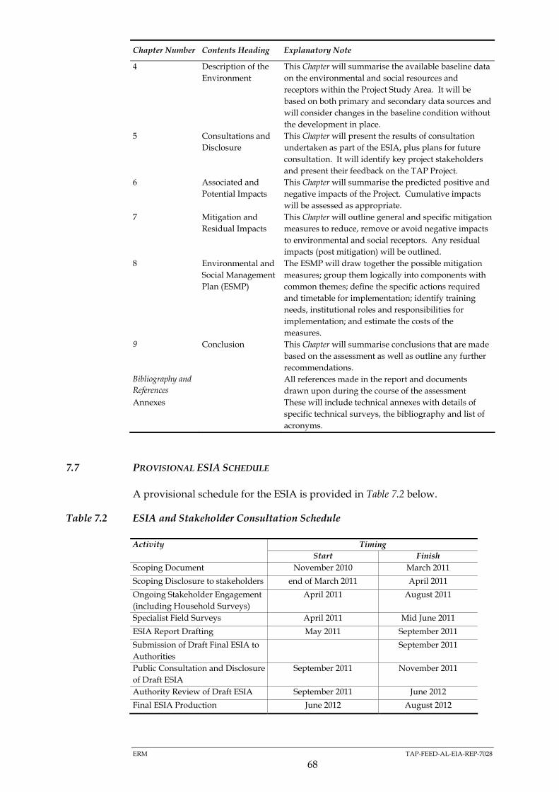
ERM TAP-FEED-AL-EIA-REP-7028
68
Chapter Number Contents Heading Explanatory Note
4 Description of the
Environment
This Chapter will summarise the available baseline data
on the environmental and social resources and
receptors within the Project Study Area. It will be
based on both primary and secondary data sources and
will consider changes in the baseline condition without
the development in place.
5 Consultations and
Disclosure
This Chapter will present the results of consultation
undertaken as part of the ESIA, plus plans for future
consultation. It will identify key project stakeholders
and present their feedback on the TAP Project.
6 Associated and
Potential Impacts
This Chapter will summarise the predicted positive and
negative impacts of the Project. Cumulative impacts
will be assessed as appropriate.
7 Mitigation and
Residual Impacts
This Chapter will outline general and specific mitigation
measures to reduce, remove or avoid negative impacts
to environmental and social receptors. Any residual
impacts (post mitigation) will be outlined.
8 Environmental and
Social Management
Plan (ESMP)
The ESMP will draw together the possible mitigation
measures; group them logically into components with
common themes; define the specific actions required
and timetable for implementation; identify training
needs, institutional roles and responsibilities for
implementation; and estimate the costs of the
measures.
9 Conclusion This Chapter will summarise conclusions that are made
based on the assessment as well as outline any further
recommendations.
Bibliography and
References
All references made in the report and documents
drawn upon during the course of the assessment
Annexes These will include technical annexes with details of
specific technical surveys, the bibliography and list of
acronyms.
7.7 PROVISIONAL ESIA SCHEDULE
A provisional schedule for the ESIA is provided in Table 7.2 below.
Table 7.2 ESIA and Stakeholder Consultation Schedule
Activity Timing
Start Finish
Scoping Document November 2010 March 2011
Scoping Disclosure to stakeholders end of March 2011 April 2011
Ongoing Stakeholder Engagement
(including Household Surveys)
April 2011 August 2011
Specialist Field Surveys April 2011 Mid June 2011
ESIA Report Drafting May 2011 September 2011
Submission of Draft Final ESIA to
Authorities
September 2011
Public Consultation and Disclosure
of Draft ESIA
September 2011 November 2011
Authority Review of Draft ESIA September 2011 June 2012
Final ESIA Production June 2012 August 2012

ERM TAP-FEED-AL-EIA-REP-7028
69
8 STAKEHOLDER ENGAGEMENT
8.1 INTRODUCTION
TAP considers consultation and engagement with stakeholders an integral
part of the Environmental and Social Impact Assessment (ESIA) process. In
line with the development of the Albanian section of the proposed Trans-
Adriatic Pipeline, TAP has developed a Stakeholder Engagement Strategy the
overall aim of which is to ensure that a consistent, comprehensive,
coordinated and culturally appropriate approach is taken for stakeholder
consultation and disclosure. The approach taken by TAP is in full compliance
with Albanian EIA Regulations, EBRD Performance Requirements, as well as
relevant policies of the IFC and World Bank.
TAP intends to undertake a process of stakeholder engagement through
project planning, construction, operation and decommissioning phases. The
plan for this engagement, including identification of stakeholders (i.e. people
and organisations who have a role in the project or could be affected by the
project activities or who are interested in the project) and disclosure of
information, consultation, and handling of suggestions, comments and
concerns, is documented in the Albania Stakeholder Engagement Plan. This
plan will be updated as required as the project progresses.
In Section 8.2 an overview of stakeholder engagement phases planned
throughout the project is presented. The engagement activities planned
during the scoping phase are further detailed in Section 8.3
8.2 STAKEHOLDER ENGAGEMENT PHASES FOR TAP PROJECT
8.2.1 Overview
To fulfil the objectives of stakeholder engagement, the TAP Project has
developed a plan for engagement with stakeholders through Project life-cycle.
The plan lays out a process for consultation and disclosure through five
stages, each having slightly different objectives. These stages are described in
Table 8.1.
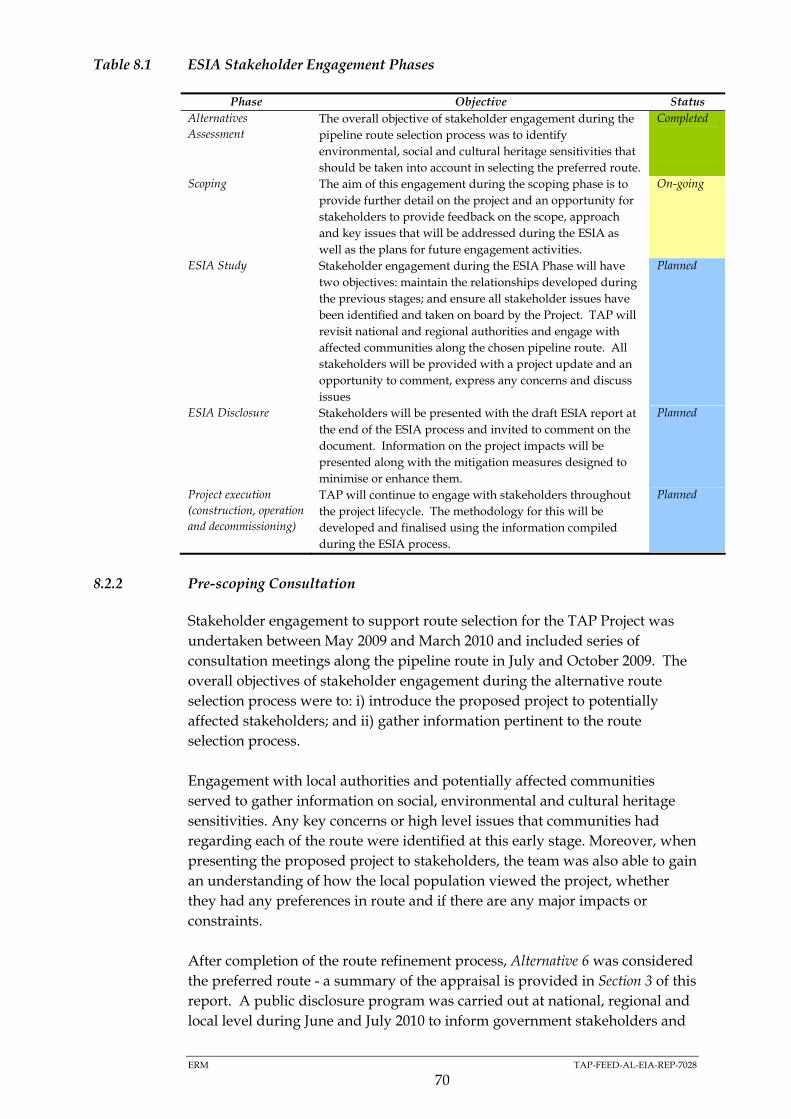
ERM TAP-FEED-AL-EIA-REP-7028
70
Table 8.1 ESIA Stakeholder Engagement Phases
Phase Objective Status
Alternatives
Assessment
The overall objective of stakeholder engagement during the
pipeline route selection process was to identify
environmental, social and cultural heritage sensitivities that
should be taken into account in selecting the preferred route.
Completed
Scoping The aim of this engagement during the scoping phase is to
provide further detail on the project and an opportunity for
stakeholders to provide feedback on the scope, approach
and key issues that will be addressed during the ESIA as
well as the plans for future engagement activities.
On-going
ESIA Study Stakeholder engagement during the ESIA Phase will have
two objectives: maintain the relationships developed during
the previous stages; and ensure all stakeholder issues have
been identified and taken on board by the Project. TAP will
revisit national and regional authorities and engage with
affected communities along the chosen pipeline route. All
stakeholders will be provided with a project update and an
opportunity to comment, express any concerns and discuss
issues
Planned
ESIA Disclosure Stakeholders will be presented with the draft ESIA report at
the end of the ESIA process and invited to comment on the
document. Information on the project impacts will be
presented along with the mitigation measures designed to
minimise or enhance them.
Planned
Project execution
(construction, operation
and decommissioning)
TAP will continue to engage with stakeholders throughout
the project lifecycle. The methodology for this will be
developed and finalised using the information compiled
during the ESIA process.
Planned
8.2.2 Pre-scoping Consultation
Stakeholder engagement to support route selection for the TAP Project was
undertaken between May 2009 and March 2010 and included series of
consultation meetings along the pipeline route in July and October 2009. The
overall objectives of stakeholder engagement during the alternative route
selection process were to: i) introduce the proposed project to potentially
affected stakeholders; and ii) gather information pertinent to the route
selection process.
Engagement with local authorities and potentially affected communities
served to gather information on social, environmental and cultural heritage
sensitivities. Any key concerns or high level issues that communities had
regarding each of the route were identified at this early stage. Moreover, when
presenting the proposed project to stakeholders, the team was also able to gain
an understanding of how the local population viewed the project, whether
they had any preferences in route and if there are any major impacts or
constraints.
After completion of the route refinement process, Alternative 6 was considered
the preferred route - a summary of the appraisal is provided in Section 3 of this
report. A public disclosure program was carried out at national, regional and
local level during June and July 2010 to inform government stakeholders and
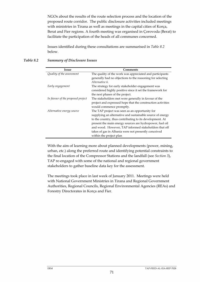
ERM TAP-FEED-AL-EIA-REP-7028
71
NGOs about the results of the route selection process and the location of the
proposed route corridor. The public disclosure activities included meetings
with ministries in Tirana as well as meetings in the capital cities of Korça,
Berat and Fier regions. A fourth meeting was organised in Çorovoda (Berat) to
facilitate the participation of the heads of all communes concerned.
Issues identified during these consultations are summarised in Table 8.2
below.
Table 8.2 Summary of Disclosure Issues
Issue Comments
Quality of the assessment The quality of the work was appreciated and participants
generally had no objections to the reasoning for selecting
Alternative 6.
Early engagement The strategy for early stakeholder engagement was
considered highly positive since it set the framework for
the next phases of the project.
In favour of the proposed project The stakeholders met were generally in favour of the
project and expressed hope that the construction activities
would commence promptly.
Alternative energy source The TAP project was seen as an opportunity for
supplying an alternative and sustainable source of energy
to the country, thus contributing to its development. At
present the main energy sources are hydropower, fuel oil
and wood. However, TAP informed stakeholders that off
takes of gas in Albania were not presently conceived
within the project plan
With the aim of learning more about planned developments (power, mining,
urban, etc.) along the preferred route and identifying potential constraints to
the final location of the Compressor Stations and the landfall (see Section 3),
TAP re-engaged with some of the national and regional government
stakeholders to gather baseline data key for the assessment.
The meetings took place in last week of January 2011. Meetings were held
with National Government Ministries in Tirana and Regional Government
Authorities, Regional Councils, Regional Environmental Agencies (REAs) and
Forestry Directorates in Korça and Fier.

ERM TAP-FEED-AL-EIA-REP-7028
72
8.3 SCOPING PHASE STAKEHOLDER ENGAGEMENT
8.3.1 Objectives
The objective of engagement during the scoping phase is to provide further
detail on the project and an opportunity for stakeholders to provide feedback
on the scope, approach and key issues that will be addressed during the ESIA
study phase as well as the plans for future engagement activities.
The main emphasis of the scoping phase engagement is to present the project
to government agencies, NGOs and other key groups as well as to community
leaders. These organisations are listed in Table 8.3 below. Information will
also be disseminated to local communities and to the general public and
channels will be opened to receive their feedback.
Table 8.3 Key Stakeholder Groups for ESIA Phase Engagement
Stakeholder Group Stakeholder
National Government
Stakeholders
Ministry of Environment, Forest and Water Administration
Ministry of Agriculture, Food and Consumer Protection
Ministry of Economy, Trade and Energy (METE)
National Licensing Centre (QKL)
Albanian National Agency of Natural Resources (AKBN)
Ministry of Tourism, Culture and Sports
Ministry of Public Works, Transport and Telecommunication
(MPTT)
Ministry of Defence
Ministry of Interior
Albanian Energy Regulator (ERE)
Central Immovable Property Registration Office (IPRO)
NGOs and Other
interested parties
NGOs (including regional/local)
Community Groups
Community Based Organizations (CBOs)
Academic and Research Organisations
International Development Agencies
Media
Others tbd
Regional Government
Stakeholder
Regional Government (Korça, Berat and Fier Prefectures)
Heads of Regions
Regional Councils
Regional Environmental Agencies (REAs)
Regional Road Directorates
Regional Forests Directorates
Regional Immovable Property Registration Office (IPROs)
Local stakeholders 29 Heads of Communes/Municipalities
62 Heads of Villages
General Public
The complete list of stakeholder groups, individual organisations and
communities is presented in Appendix C.

ERM TAP-FEED-AL-EIA-REP-7028
73
8.3.2 Stakeholder Engagement Activities
Overview
Stakeholder meetings are planned in Tirana as well as in the regions to
facilitate the participation of all concerned stakeholders, in particular heads of
villages travelling from remote areas. The schedule for these meetings is
shown in Table 8.4.
Specific activities to disclose information and seek comments from different
stakeholder groups are summarised in the subsequent sections.
Table 8.4 Scoping Meetings
Type of Engagement Venue
11-15th April 2011 One to one meetings with National
Government stakeholders
Scoping Meeting with NGOs and other
interested parties
Tirana
26-29th April 2011 4 regional scoping meetings (Regional and
Communal Authorities and Heads of Villages
and local NGOs)
Korça, Berat,
Çorovoda and Fier
Engagement with National Government Stakeholders
National government agencies have expressed a preference for one to one
meetings with the TAP Project to discuss the project and the scoping report.
Consequently it is planned to send this document (ESIA Scoping Document,
ESD) in Albanian to national government stakeholders, with a covering letter
inviting them to a one to one meeting with TAP. The letter will also advise
them of the Project and the ESIA study.
Both the letter and the ESD will be sent 15 days before the date of each of the
proposed one to one meeting.
Engagement with NGOs and Other Organisations
The ESD will be sent to NGOs, including regional NGOs, and other interested
parties accompanied by a letter inviting them to participate in a scoping
meeting in Tirana. Both the ESD and the letter will be sent 15 days in advance
of the scoping meeting to allow an in-depth review of the document during
the meeting.
At the scoping meeting, it is planned to provide a presentation of the project
and of the scoping report prior to opening the meeting to questions and
comments. Participants will be able to pose the questions or raise the issues as
well as to submit follow -up questions and comments during the meeting
through comments sheets or subsequently send them by post or through the
Project web site.

ERM TAP-FEED-AL-EIA-REP-7028
74
Engagement with Regional, Communal Authorities and Heads of Villages
Regional, communal and village level government stakeholders will be
invited together to participate in one of the four scoping meetings to be
organised by TAP. In preparation for the meetings, TAP will send the ESD in
Albanian to all of them, with a covering letter inviting them to the scoping
meeting in their respective regions. The letter will also advise them of the
Project and the ESIA study.
Both the letter and the ESD will be sent 15 days before the date of the relevant
scoping meeting.
Engagement with Local Communities
TAP/ENT is committed to continue engaging and consulting with affected
communities along the chosen pipeline route to ensure that the project is fully
explained to local communities and that their concerns and views on the
Project are heard and taken into account.
During scoping, the main channel of communication will be the Heads of
Villages. Heads of Villages will participate to the regional scoping meetings
representing their constituencies and as such will have a role to play in further
disseminating information on the project and in making accessible the copies
of the ESD for the individual stakeholders.
For this purpose a shorter leaflet and accompanying poster with information
about the ESIA Scoping Process and the feedback mechanism will be
distributed to all Villages Heads during the regional scoping meetings for
onwards distribution to communities (see above). Villages Heads will
officially be asked to put up the poster and the leaflets in an accessible place in
each village or town (i.e. communal premises, school building). In addition a
daily notice will be broadcasted in local radio stations the week before and
after the regional meetings to make sure all community members and other
interested parties locally are informed about the Project and the ESIA Scoping
process as well as the mechanism to provide comments on the Project.
Further consultation will be carried out with local community members
including vulnerable populations and gender groups during the ESIA study
phase. Moreover, all communities will be invited to participate in open public
hearings during disclosure of the final ESIA report when information on the
project impacts will be presented along with the mitigation measures
designed to avoid or minimise them.
General Public
A notice will be written for national newspapers to ensure that interested
parties and the general public outside the direct area are informed about the
Project and the ESIA Scoping process.

ERM TAP-FEED-AL-EIA-REP-7028
75
The ESD will also be placed on the Project website with an email address for
submitting the comments.
8.4 GRIEVANCE MECHANISM
In accordance with international best practice, a process has been set up
through which any person or organisation can contact the project to ask a
question or raise a concern. This process will be detailed in the project
Environmental and Social Management Plan (ESMP) and will accord with
EBRD standards. It will be open and accessible to all, designed to suit the
varying cultural needs of all potential stakeholders, and will deal with
grievances in a fair and transparent manner. All grievances will be recorded
and responded to promptly before being closed.
The grievance mechanism is part of TAP’s broader process of stakeholder
engagement and quality and compliance assurance. While TAP is committed
to avoid grievances through its dedication to a good overall stakeholder
engagement process, the Project is aware that grievance and complains will
occur and need to be addressed in good faith and through a transparent and
impartial process.
Details on the grievance process, including grievance forms, are available on
the Project website. They will also be conveyed to Villages Heads during the
scoping engagement.
8.5 RESOURCES AND RESPONSIBILITIES
Stakeholder engagement is an integrated element of TAP’s core business
activities and is managed with the same principles as all other business
functions: with clearly defined objectives and targets, professional, dedicated
staff, established timelines and budgets, responsibility, accountability and
oversight. TAP recognizes the importance of dedicating appropriate resources
to the engagement process and establishing clear lines of responsibility.
8.6 PUBLIC COMMENTS AND SUGGESTIONS
An important objective of the ESIA Scoping disclosure process is to allow
stakeholders to provide feedback on the Project. In this regard, TAP has
envisaged a process that allows stakeholders to address their comments and
suggestions in writing to TAP after the scoping meetings have taken place.
In this regard, TAP would like to invite all stakeholders involved in the
scoping process, including local communities and the general public, to
submit in writing their comments and suggestion concerning the Albanian
section of the Trans Adriatic Pipeline (TAP) until 30th June 2011.
Appendix B presents a standard form to facilitate the submission of comments
and suggestions in both English and Albanian. Participants to the scoping

ERM TAP-FEED-AL-EIA-REP-7028
76
meetings as well as the general public interested in the project are invited to
submit comment forms either via mail or E-mail to the following address:
Trans Adriatic Pipeline AG – Albania (Branch Office)
Torre Drin, Abdi Toptani Street
Phone: + 355 44 308 770
Fax: + 355 42 265 685
Tirana, Albania
www.trans-adriatic-pipeline.com

Appendix A
Maps
(TAP-FEED-AL-EIA-REP-7028)


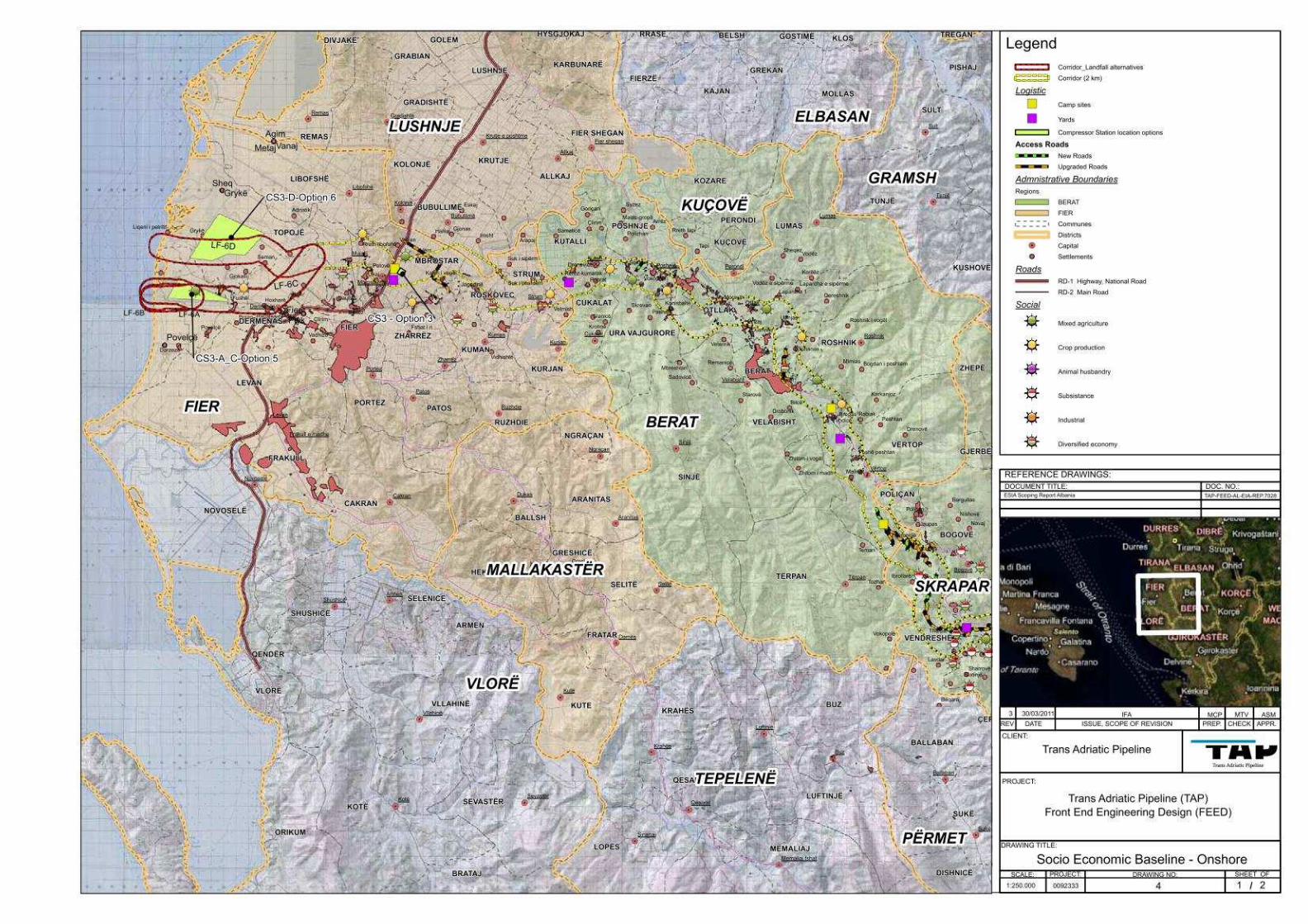


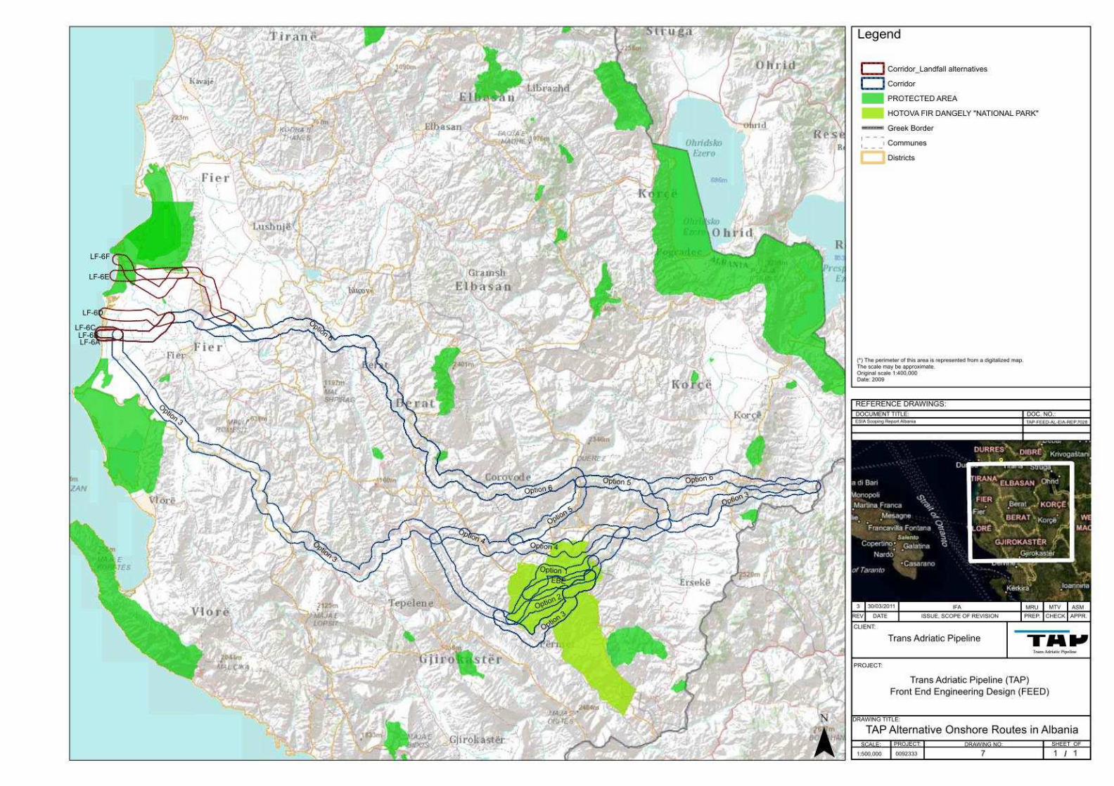

Appendix B
Comments Form
(TAP-FEED-AL-EIA-REP-7028)

Public Comments & Suggestions Form Concerning the Trans Adriatic Pipeline (TAP) ESIA Scoping Document
Full Name, Surname
_________________________________________________
Contact information (please fill in how you want to be contacted):
Post Address ______________________________
______________________________
______________________________
Telephone ______________________________
E-Mail ______________________________
Preferred contact Language Albanian English
Please note here your suggestions and comments concerning the Albanian section of the Trans Adriatic Pipeline (TAP) Project
__________________________________________________________________
__________________________________________________________________
__________________________________________________________________
__________________________________________________________________
__________________________________________________________________
__________________________________________________________________
__________________________________________________________________
__________________________________________________________________
__________________________________________________________________
__________________________________________________________________
__________________________________________________________________
__________________________________________________________________
__________________________________________________________________
__________________________________________________________________
__________________________________________________________________
__________________________________________________________________
Please send this form back to: Trans Adriatic Pipeline AG – Albania (Branch Office)
Torre Drin, Abdi Toptani Street Phone: + 355 44 308 770
Fax: + 355 42 265 685 Tirana, Albania
www.trans-adriatic-pipeline.com [email protected]
Reference No.
Received on
Received by

Appendix C
Stakeholders List
(TAP-FEED-AL-EIA-REP-7028)

CONTENTS
1 NATIONAL GOVERNMENT STAKEHDOLERS 2
2 REGIONAL AND LOCAL GOVERNMENT STAKEHDOLERS 3
3 NGOS AND OTHER INTERESTED PARTIES (NATIONAL & REGIONAL) 6

TAP TAP-FEED-AL-EIA-REP-7028
2
1 NATIONAL GOVERNMENT STAKEHDOLERS
Institutions Department
Ministry of Environment, Forest and Water Administration
General Policy Directorate Department of Forests and Pastures Department of Environmental Protection Directorate of Biodiversity Fishery Directorate
Ministry of Economy, Trade and Energy
General Policy Directorate Department of International Business Department of Licensing and Concessions Directorate of Strategic Planning Department of Business Development Department of Energy Policy
AKBN - Albanian National Agency of Natural Resources
Hydropower Sector Hydrocarbon Sector
Albanian Geological Survey Director
ERE Director for Licensing
Ministry of Tourism, Culture and Sports
Directorate of Tourism Directorate of Culture Heritage
Archaeological Service Agency
Directorate of Archaeology
National Council for Archaeology
Director
Ministry of Public Works, Transport and Telecommunication
Directorate of Policy and Planning for Transport Directorate of Road Transport Policies Directorate of General Construction and Housing Policy Directorate for Water and Waste Water General Directorate of Maritime
National Agency for Territorial Planning
General Director Deputy General Director
Albanian Development Fund Department of Infrastructure Department of Regional Development
Ministry of Defence General Secretary Logistics Department Albanian Joint Forces Navy
Ministry of Agriculture, Food and Consumer Protection
General Secretary General Directorate of Policies (GDoP) General Directorate of Resources management
Central Immovable Property Registration Office
Director
Inter- institutional structure of the Control of the Marine Space (QNOD)
Representatives from member Ministries

TAP TAP-FEED-AL-EIA-REP-7028
3
2 REGIONAL AND LOCAL GOVERNMENT STAKEHDOLERS
Region District Commune/ Municipality Settlements (Villages and
towns)
Within the 2 km corridor
KORÇË DEVOLL Miras Çetë Maja e Pocroves Miras Sinicë KORÇË Drenovë Dardhë Mollaj Kamenicë Ujëbardhë Vithkuq (none) BERAT BERAT Berat Berat Uznovë Cukalat (none) Kutalli Drenovicë Kutalli Pobrat Protoduar Rërëz-kumarak Sqepur Otllak Moravë Otllak Ullinjas Poshnjë Çiflik Poshnjë Roshnik (none) Tërpan (none) Ura Vajgurore Guri i bardhë Konisbaltë Ura vajgurore Vokopolë Velabisht Duhanas Malinat Vërtop Bregas Fushë peshtan Mbrakull Vërtop Vodicë

TAP TAP-FEED-AL-EIA-REP-7028
4
Region District Commune/ Municipality Settlements (Villages and
towns)
Within the 2 km corridor
BERAT SKRAPAR Bogove Ustië Valë Çorovoda Çorovoda Poliçan Zgërbonjë Potom Backë Qafë Qendër Arizaj Buzuk Çerenishte Munushtir Orizaj Osoje Polenë Vendreshe Therpel Vëndreshë e vogël FIER FIER Dermenas Dermenas Hamil Hoxharë Sulaj Kurjan (none) Libofshë Rreth libofshë Mbrostar Kallm i vogël Mbrostar ura Petovë Verri Qendër Mujalli Roskovec (none) Strum Strum Topoje Fushë Kavaklli Seman Seman i ri Topojë LUSHNJE Bubullimë (none)

TAP TAP-FEED-AL-EIA-REP-7028
5
Table 2.1 List of Participants for Regional Consultation Meetings
Authority
Region
Regional Authority (Prefect) Head of Regional Council Regional Environmental Agency Regional Roads Directorate District Forestry Directorate District Immovable Property Registration Office
Municipality/Commune
Mayor/ Head of the Commune Urban Planning Department
Local Community
Head of Villages within 2 km corridor of baseline + northern landfall alternative NGOs/Civil Society
Local NGOs Other interested parties
Off-shore Authorities
Harbour Master Vlore Coastal Guard Coastal Police Customs Agencies
Note: Public Meetings and Focus Groups Discussions will be carried out in addition

TAP TAP-FEED-AL-EIA-REP-7028
6
3 NGOS AND OTHER INTERESTED PARTIES (NATIONAL & REGIONAL)
Table 3.1 List of NGOs in Tirana
Name of the Organisation
1. Sustainable Economic Development Agency Agjensia e Zhvillimit Ekonomik te Qendrueshem
2. Albanian Society for the Protection of Birds and Mammals (ASPBM) Shoqata per Ruajtjen e Shpendeve dhe Kafsheve te Egra (Gjitareve) te Shqiperise
3. ASET - Economic Social Forum ASET - Forumi Shqiptar Social Ekonomik
4. Association for Development of Environmental Policies -- G & G Group Shoqata për "Zhvillim të Politikave Mjedisore - G & G group"
5. Association for Evaluation of Environment, Energy, Nature Shoqata p r Vler sim Mjedisi, Energji, Natyr - Menvgroup
6. Association for Protection of Water Fauna Shoqata e Mbrojtjes së Gjallesave Ujore të Shqipërisë
7. Association of Conservation and Protection of Natural Environment in Albania Shoqata e Ruajtjes dhe e Mbrojtjes se Mjedisit Natyror ne Shqiperi
8. Center of Study and Consulting in Sustainable Use and Management of Natural Resources Qendra e Studimeve dhe Konsultimeve per Perdorimin e Qendrueshem te Burimeve Natyrore
9. Co-PLAN 10. EDEN - Environmental Centre for Development, Education and Networking 11. Eko-Movement Group
Qendra e Grupimit “Ekolëvizja”
12. Environmental and Social Protection and development 'Iliria' Shoqata 'Mbrojtja dhe zhvillimi mjedisor e social ILIRIA'
13. Environmental Women Association Gruaja Ambjentaliste Shqiptare
14. Albanian Civil Society Foundation Fondacioni Shqiptar i Shoqerise Civile-FSHSHC
15. For New Environmental Policies Per politikat e reja Ambjentale
16. Forest Progress NGO OJF 'Progresi Pyjor'
17. ICAA - International Centre for Albanian Archaeology Qendra Nderkombetare per Arkeologjine Shqiptare
18. Institute for Environmental Policy Instituti i Politikave Mjedisore
19. Institute of Environmental Studies Instituti i Studimeve Ambjentale
ARHUS
20. Institute of Nature Conservation in Albania Instituti per Ruajtjen e Natyres ne Shqiperi
21. Institute of Environmental Studies Instituti i Studimeve Ambjentale
22. Institute for the Study of Nature and Environmental Education in Albania Instituti Për
Studimin e Natyrës dhe Edukimin ambjental ne Shqiperi
23. Kadmi and Harmonia 24. Junior environmental club
Klubi Fëmijënor i Mjedisit, Tiranë
25. Klubi Mjedisor "Perla” Environmental Club "Perla”

TAP TAP-FEED-AL-EIA-REP-7028
7
Name of the Organisation
26. Youth Environmental Club "PNL” Klubi Rinor Mjedisor "PNL
27. Albanian Students Environmental Club Klubi Studentor Ambjentalist Shqiptar
28. National Association of Cooperatives of Albania Bashkimi i Kooperimeve Agrare te Shqiperise
29. National Environmental Movement Center Qendra Kombëtare e Lëvizjes Ambientaliste
30. National Resource Centre for Training and Technical Assistance Qendra Kombetare Burimore e Trajnimit dhe Asistences Teknike (ANTTARC)
31. Eco-counseling Center Qendra për Eko-këshillime
32. Centre for Environmental Research and DevelopmentQendra Shqiptare për Studime dhe Zhvillime Mjedisore
33. SEDA www.seda.org.al
34. "The new Ecolog" Association Shoqata “Ekologu i Ri”
35. Association "Lawyers for Environmental Protection" Shoqata “Juristët për Mbrojtjen e mjedisit”
36. Association of Municipalities of Albania Shoqata e Bashkive te Shqiperise
37. Agriculture Organic Association Shoqata e Bujqësisë Organike
38. Hygienist Association of Albania Shoqata e Higjienistëve të Shqipërisë
39. Albanian Ecological Association of Engineering Shoqata e Inxhinierisë Ekologjike Shqiptare
40. Association of Communes Shoqata e Komunave te Shqiperise
41. Association for the Preservation of Birds and Wildlife of Albania Shoqata për Ruajtjen e Shpendëve dhe Kafshëve te egera te Shqiperise
42. Social Science Association "Environment and Health" Shoqata Shkencore Shoqerore "Mjedisi dhe Shendeti"
43. Stimulating Program for Social Alternatives Programi i Alternativave Social Stimuluese
44. URI - Urban Research Institute Instituti i Kerkimeve Urbane
45. Zyra Per Mbrojtjen e Qytetareve Citizens Advocacy Office
46. Albanian Fund for Monuments Fondi Shqiptar per Monumentet
47. Albanian Heritage Center Qendra/Forumi per Mbrojtjen e Trashegimise

TAP TAP-FEED-AL-EIA-REP-7028
8
Table 3.2 Regional NGO
Name Region
Association for the Protection of Environment and Nature Shoqata Per Mbrojtjen e Mjedisit Natyror
Berat
Regional Development Agency Agjensia Rajonale e Zhvillimit Berat Protection of social rights of Kucove Mbrojtja e te Drejtave Sociale Kucove
Berat
Ecologic club of Fier Klubi ekologjik I Fierit
Fier
Ecological Club Klubi Ekologjik, Fier
Fier
Regional Development Agency Agjencia Rajonale e Zhvillimit
Fier
Fishermen Association Vlore Korca, Rural, Agroturizmi Korçë Tourism and Environment Turizmi dhe Mjedisi
Korçë
Transborder Wildlife Natyra Ndërkufitare
Korçë
D.R.K.K. Archaeology Sector Archaeology Museum Muzeumi Arkeologjik
Korçë
Kamenica Museum Muzeu Kamenices
Korçë
Environmental association of Morava Shoqata mjedisore e Moraves
Korçë
Environmental association of Morava Shoqata mjedisore e Moraves
Korçë
Association of private forests and pasture Shoqata e pyjeve dhe kullotave private
Korçë
Agro-tourism association Shoqata e agroturizmit
Korçë
Youth Environmental Club "Perla” Klubi Rinor Mjedisor "Perla”
Korçë
Amaro Drom Skrapar
Table 3.3 Universities and Research Centres
Name of the Organisation Purpose
1. Tirana State University School of Agriculture and EnvironmentSchool of Forestal Sciences School of Biotechnologies
Informant on Agriculture, Environment, Forestry issues
2. University of Mining Informant on geological issues 3. Research Center for Flora
and Fauna of Albania (RCFFA) University of Tirana Qendra Kerkimore per Floren dhe Faunen e Shqiperise (QKFFSH)
Public research centre on flora and fauna in the Country

TAP TAP-FEED-AL-EIA-REP-7028
9
Table 3.4 List of Other Interested Parties
Name of the Organisation Purpose
1. EBRD - European Bank for Reconstruction and Development
Strengthen state institutions; invest in infrastructure, including upgrading of national, regional and local road transport networks; further strengthen the banking system; support SMEs / MSEs
2. GIZ - German Cooperation Company
German cooperation company. Has projects with national coverage on water supply and treatment, energy, vocational training.
3. REC - Regional Environmental Centre
International Network active in the field of Environment - Agriculture - Forestry
4. Swiss Cooperation Office Albania
Considers Albania as a priority country Works in various regions of Albania including Fier, Korçe amd Berat.
5. Tirana Chamber of Commerce
Tirana Chamber of Commerce
6. UNDP United Nations Development Programme
Supports projects for the identification a prioritization of contamination hotspots in Albania. Informant on soil contaminated areas.
7. USAID - United States Agency for International Development (USAID)
Coordinates local development projects in various cities including Fier and Korçe
8. WB - World Bank Supports projects in the infrastructure sector. Supports participatory forest and pasture management planning and investment in 240 rural communes through the National Resource Development Project (NRDP)

Appendix D
ESIA Action Plan
(TAP-FEED-AL-EIA-REP-7028)

TAP TAP-FEED-AL-EIA-REP-7028
1
Table 1.1 Environmental Desk-top, Field and Modeling Activities – Onshore
Resource Approach Parameters Period
Surface and Ground Water
Desk: • Bibliographical/desk based literature
review • Remote sensing interpretation using aerial
photographs or satellite imagery. Field study: (i) Sampling and analysis of selected main crossings of permanent rivers, streams, creeks, channels.
(ii) Collect groundwater samples from selected existing wells within 500 m from the selected route Output: • Mapping of air quality sensitive receivers
(the scale of cartography will range from 1:5,000 – 1: 50,000)
• Characterisation of baseline water quality at survey locations
(i) Surface Water: The following data will be collected: River morphology and channel descriptions Water Quality – physico-chemical parameters Sediment Quality (for potentially contaminated rivers only). - physico-chemical and biological parameters (ii) For groundwater: physico-chemical parameters
Timing of field surveys: April – mid May

TAP TAP-FEED-AL-EIA-REP-7028
2
Resource Approach Parameters Period
Vegetation & Flora Desk: • Bibliographical search; and • Remote sensing analysis: Field study: A team of ecologists and flora experts will conduct a survey of the terrestrial environment to describe the existing habitat type and identify flora species of interest. Surveys will be performed only for areas of ecological and conservational interest. Specific field surveys will also have be conducted for the Appropriate Assessment on Natura 2000. Output: • Flora species list and distribution • Vegetation map: the scale of cartography
will range from 1:5,000 – 1: 50,000. • Characterisation of vegetation and flora at
survey locations
• Vegetation and flora surveys will focus on species of conservation interest and priority habitats
• Endangered and other endemic/important species under Albanian, EU and Council of Europe
Timing of field surveys: late Aril – early July

TAP TAP-FEED-AL-EIA-REP-7028
3
Resource Approach Parameters Period
Fauna & Habitats Desk: • Bibliographical search; and • Remote sensing analysis: Field study: A team of ecologists and fauna experts will conduct a survey of the terrestrial environment to describe the existing habitat type and identify fauna species of interest. Surveys will be performed only for areas of ecological and conservational interest. Aspects to be identified: • Habitat types • Fauna species list and distribution • Sensitive habitats Specific field surveys will also have be conducted for the detailed assessment of protected areas. Output: • Fauna species list and distribution • Habitat Map: the scale of cartography will
range from 1:5,000 – 1: 50,000. • Characterisation of fauna and habitats at
survey locations
Vertebrates, particularly focusing on species of interest, including: • Priority fauna species (Bear, wolf, Otter) • Nesting Birds • Fish • Amphibians, reptiles, small mammal Macroinvertebrates
Timing of field surveys: middle April – Late September • Priority fauna species (Bear, wolf, Otter): Mid
April, and August-October • Nesting Birds: April- May • Fish: April and August • Amphibians, reptiles, small mammals: Mid
April and Aug-September • Macroinvertebrates: April – early May

TAP TAP-FEED-AL-EIA-REP-7028
4
Resource Approach Parameters Period
Air Desk: • Bibliographical and desk based literature
review Field Study: • Air quality data will be recorded only for
the compressor stations • A specialist will conduct a study to
determine the status of local air quality using existing monitoring data or by conducting measurements. Measurements will be conducted using an air quality monitoring station.
• Air quality sampling, using diffusion tubes, at villages near proposed Compressor Stations locations over a minimum of four weeks.
Output: • Mapping of air quality sensitive receivers
(the scale of cartography will range from 1:5,000 – 1: 50,000)
• Characterisation of baseline air quality at proposed compressor station site
• Modeling of emission dispersion from compressor operation only.
Parameters to be measured will include: • Oxides of nitrogen (NOx) • Sulphur dioxide (SO2) • Hydrocarbons (VOCs). • Carbon Monoxide (CO)
• Timing of field surveys: April – end of May • Timing of Modeling: June

TAP TAP-FEED-AL-EIA-REP-7028
5
Resource Approach Parameters Period
Noise & Vibration Desk: • Bibliographical and desk based literature
review. Field Study: • Noise data will be recorded only for the
compressor stations • A specialist will conduct a study of
ambient noise levels. The study will identify locations of sensitive receptors. Both short term and long term measurements are to be collected. Measurements are to be taken continuously during the day and the night time (24 hours) at villages near proposed Compressor Stations locations.
• Moreover, hourly measurements at villages close to the selected pipeline route other project features (accesses, pipe yards, etc.) that may be impacted temporarily by construction activities.
Output: • Mapping of noise sensitive receivers (the
scale of cartography will range from 1:5,000 – 1: 50,000)
• Characterisation of baseline noise levels at proposed compressor station site
• Modeling of noise emissions at sensitive receivers close to compressor stations.
• Acoustical measurements using a Type I or Type II integrating sound level meter monitoring the slow response, A-weighted, equivalent sound pressure level (Leq) at selected location
• Timing of field surveys: April – end of May • Timing of Modeling: June
Light Pollution • Identify sources of light emissions, potential sensitive receptors and view points
• Light emissions and potential sensitive receivers
N/A

TAP TAP-FEED-AL-EIA-REP-7028
6
Resource Approach Parameters Period
Soil
Desk: • Bibliographical/desk based literature
review, including project information • Remote sensing interpretation using Soil
maps (1:50,000 or similar) and aerial photographs or satellite imagery.
Output • Geological/hydro geological cartography
to 1: 50,000 scale along the selected corridor and other project features (accesses, pipe yards etc.).
Desk: • Bibliographical/desk based literature
review, including project information • Remote sensing interpretation using aerial
photographs or satellite imagery. Field study; • The soil specialist will undertake study of:
- soil physico-chemical characteristics; - existing soil contamination; - Economic value of soil types
Investigation will include analysis of soil samples of upper layers of soil at locations with agricultural land use and areas of potential soil contamination. The soil specialist will also conduct visual assessment of soils for fertility parameters.
• Timing of field surveys: April – mid May

TAP TAP-FEED-AL-EIA-REP-7028
7
Resource Approach Parameters Period
Landscape Desk: • GIS desk top analysis to assess landscape
quality width. Special attention will be given to: - Compressor and block valve stations
locations - Areas of high landscape value
(mountain areas, forested areas, etc.) • 3D simulations on the Compressor Stations
to include: - View sheds analyses - 3D simulation
Field Visual assessment during corridor survey Output. • Mapping of landscape quality (the scale of
cartography will range from 1:5,000 – 1: 50,000)
• Characterisation of landscape within areas of high landscape value
• 3D Model of compressor station
• Location of visual sensitive receivers • Characterisation of landscape where
permanent structures will be located
• Timing of field surveys: April – end of May • Timing of Modeling: June

TAP TAP-FEED-AL-EIA-REP-7028
8
Table 1.2 Cultural Heritage Desk-top and Field Survey Activities – Albania Onshore
Resource Approach Parameters Period
Cultural Heritage Resources
Desk: • Bibliographic search • Identification/mapping of areas of high
archaeological potential Field : • Initial field reconnaissance • Detailed Field survey • Fieldwork will not cover all areas of the
project area with equal attention but will focus on area shown by the predictive model and density of know sites to have the highest archaeological potential.
Output. • Characterisation of CH elements • The scale of cartography will range from
1:5,000 – 1: 50,000.
• Monuments, buildings and above ground structures of cultural interest
• Intangible Cultural Heritage (ICH) • Archaeological sites
• Timing of field surveys: April – June

TAP TAP-FEED-AL-EIA-REP-7028
9
Table 1.3 Socioeconomic Desk-top and Field Survey Activities – Albania Onshore
Resource Approach Parameters Period
Traffic and Transport Desk: • Desk based review of existing information
on regional transport network, including rural roads
• Description of the current status of vehicle traffic on the roads affected by the project and assessment of the integrity of Project transportation routes.
Field: • The social experts deployed in the field will
identify major junctions and key areas where project traffic could become an issue related to the following: - community health and safety - congestion and flow - impacts to cultural heritage
• The field study will be based on both interviews and observations (including traffic counts)
Output. • Municipal and Village profiles • Findings report on traffic flow on roads and
at major junctions.
• Traffic characterisation: current usage patterns and volumes
• Structural properties (load limits, traffic volume limits)
• Functionality (condition of road surface) • Transportation practices • Access routes
• Timing of field surveys: April – June

TAP TAP-FEED-AL-EIA-REP-7028
10
Resource Approach Parameters Period
Demographics and Population
Desk: • Bibliographical and desk based literature
review. • Review of official INSTAT data. • GIS / Cartography desk top analysis to
assess settlement size and distribution, • Review of data gaps and updating
information as appropriate. Field : • A team of social specialists will conduct a
survey to determine the general socioeconomic characteristics of the study area including demographics and population trends.
• As part of the survey, TAP will undertake a Household Survey to collect qualitative data including data on population and demographics.
Output. • Commune and Village profiles • Sample quantitative assessment of key
population characteristics
• Settlement patterns and mapping • Population size of settlements within 2 km
corridor and area around installations. • population trends • in and out migration • Gender and age structure • Religious and ethnic diversity, including
minorities • Vulnerable Groups (i.e. women, elderly, etc) • Education and literacy levels
• Timing of field surveys: April – June

TAP TAP-FEED-AL-EIA-REP-7028
11
Resource Approach Parameters Period
Land Use and Development
Desk: • Bibliographic search • GIS desk top analysis of land use (CORINE,
Land Sat images) Field: • The teams of social specialists deployed in
the field will ground truth GIS based information on land uses.
• The teams will assess community dependency on natural resources, including water and land, through results of focus groups and interviews with key informants, including heads of municipalities and villages.
• If a household survey is undertaken it will include questions on land ownership patterns and tenure structure and availability of alternative land.
Output: • Conduct a qualitative and quantitative
survey of the land tenure system and land use patterns in the 2 km survey corridor through household surveys
• Mapping of land use scale of cartography outputs will range between 1: 5,000 and 1:50,000
• Land use • Land ownership and tenure • Traditional land titles • Spatial planning and development • Use and dependency on natural resources,
including land for agriculture and pasture.
• Timing of field surveys: April – June

TAP TAP-FEED-AL-EIA-REP-7028
12
Resource Approach Parameters Period
Socio-Cultural Institutions and Government Administration
Desk: • Review of existing desk based (secondary)
information on the structure of socio-cultural institutions and administrations
Field: • As part of the overall socioeconomic survey
and stakeholder engagement activities the field teams will assess the presence and structure of social institutions through interviews and focus groups.
Output: Profile of administrative and community institutions
• Government structures • Presence and role of other institutions
(NGOs/CBOs) • Social organisations and institutions • Social networks, power hierarchies and
support structures • Role of women • Leadership patterns • Safety, security, law and order
Timing of field surveys: April – June
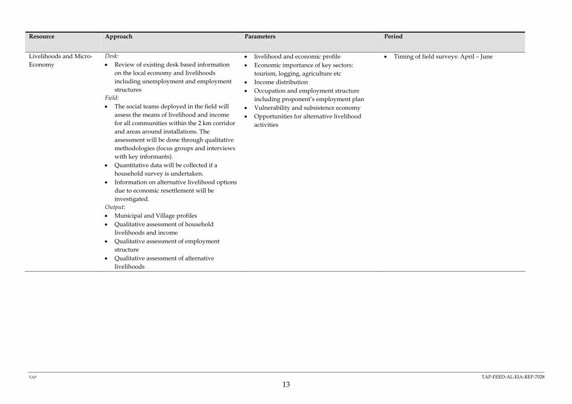
TAP TAP-FEED-AL-EIA-REP-7028
13
Resource Approach Parameters Period
Livelihoods and Micro-Economy
Desk: • Review of existing desk based information
on the local economy and livelihoods including unemployment and employment structures
Field: • The social teams deployed in the field will
assess the means of livelihood and income for all communities within the 2 km corridor and areas around installations. The assessment will be done through qualitative methodologies (focus groups and interviews with key informants).
• Quantitative data will be collected if a household survey is undertaken.
• Information on alternative livelihood options due to economic resettlement will be investigated.
Output: • Municipal and Village profiles • Qualitative assessment of household
livelihoods and income • Qualitative assessment of employment
structure • Qualitative assessment of alternative
livelihoods
• livelihood and economic profile • Economic importance of key sectors:
tourism, logging, agriculture etc • Income distribution • Occupation and employment structure
including proponent’s employment plan • Vulnerability and subsistence economy • Opportunities for alternative livelihood
activities
• Timing of field surveys: April – June

TAP TAP-FEED-AL-EIA-REP-7028
14
Resource Approach Parameters Period
Social Infrastructure Desk: • Review of existing desk based information
on infrastructures Field: • The field survey teams will visit all
settlements within the 2 km corridor and the areas around installations to assess the situation vis a vis social infrastructure and to collect relevant data to develop the municipal and village profiles.
• The teams will use a combination of observation techniques and interviews with key informants to locate infrastructures and areas of interest.
Output: • Municipal and Village profiles • List of sites of cultural and religious
significance (see Cultural heritage survey) • Mapping of sites. Scale of cartography
outputs will range between 1: 5,000 and 1:50,000
• Settlements • Key man made features • Economic, culture and historical sites • Recreational facilities (nature and location) • Cultural and religious facilities/ sites (nature
and location) • Cultural traditions • Sites of cultural and religious significance • Education and health resources (nature and
location) • Utilities (i.e. water, electricity,
telecommunications, etc)
• Timing of field surveys: April – June

TAP TAP-FEED-AL-EIA-REP-7028
15
Resource Approach Parameters Period
Community Health Desk: • Review of existing desk based information
on the health status and resources of local communities
Field: • The social teams deployed in the field will
assess the health status and health resources available to communities located within the 2 km corridor and areas around installations.
• The assessment will be done through a combination of qualitative methodologies (focus groups and interviews with key informants like doctors and nurses) and quantitative methods (if a household survey is undertaken).
Output: • Health Profile of the Villages and
Municipality • Review of health care resources • High level health capacity review
• Community health status • Health determinants • Community health needs and concerns of
host communities • Health Care resources
• Timing of field surveys: April – June
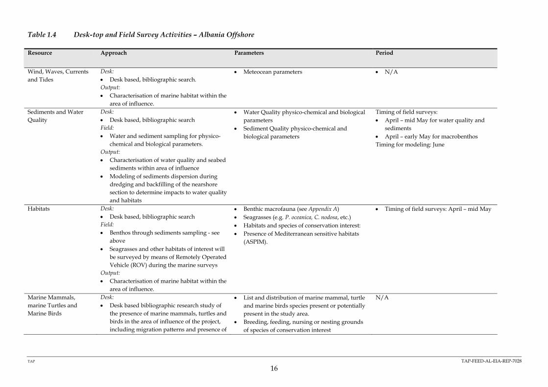
TAP TAP-FEED-AL-EIA-REP-7028
16
Table 1.4 Desk-top and Field Survey Activities – Albania Offshore
Resource Approach Parameters Period
Wind, Waves, Currents and Tides
Desk: • Desk based, bibliographic search. Output: • Characterisation of marine habitat within the
area of influence.
• Meteocean parameters • N/A
Sediments and Water Quality
Desk: • Desk based, bibliographic search Field: • Water and sediment sampling for physico-
chemical and biological parameters. Output: • Characterisation of water quality and seabed
sediments within area of influence • Modeling of sediments dispersion during
dredging and backfilling of the nearshore section to determine impacts to water quality and habitats
• Water Quality physico-chemical and biological parameters
• Sediment Quality physico-chemical and biological parameters
Timing of field surveys: • April – mid May for water quality and
sediments • April – early May for macrobenthos Timing for modeling: June
Habitats Desk: • Desk based, bibliographic search Field: • Benthos through sediments sampling - see
above • Seagrasses and other habitats of interest will
be surveyed by means of Remotely Operated Vehicle (ROV) during the marine surveys
Output: • Characterisation of marine habitat within the
area of influence.
• Benthic macrofauna (see Appendix A) • Seagrasses (e.g. P. oceanica, C. nodosa, etc.) • Habitats and species of conservation interest: • Presence of Mediterranean sensitive habitats
(ASPIM).
• Timing of field surveys: April – mid May
Marine Mammals, marine Turtles and Marine Birds
Desk: • Desk based bibliographic research study of
the presence of marine mammals, turtles and birds in the area of influence of the project, including migration patterns and presence of
• List and distribution of marine mammal, turtle and marine birds species present or potentially present in the study area.
• Breeding, feeding, nursing or nesting grounds of species of conservation interest
N/A

TAP TAP-FEED-AL-EIA-REP-7028
17
Resource Approach Parameters Period
endangered species. • Determine exposure of species present to
disturbance during marine construction works
Output: • Characterisation of marine habitat within the
area of influence.
Fish and other Commercially Interesting Species
Desk: • Desk based bibliographic research to
determine the species, reproductive seasons. and location, migration patterns etc (see below for the socio economic side of fisheries)
• Determine exposure of species present to disturbance during marine construction works
Output: • Characterisation of fisheries resources within
the area of influence. • Potential for a stock assessment based on
normal off takes if the area is found to be a breeding area for fish
• List and distribution of fish species of conservational interest or commercial interest
• Spawning, rearing grounds of species of conservation and/or commercial value
N/A
Marine Cultural Heritage
Desk: • Bibliographic search on existing data on
marine archaeological finds in and around the study area
Field : • Side Scan Sonar (SSS) • Video/ROV survey • Multibeam echosounder survey • Magnetometric survey Output: • Determine presence or potential presence of
archaeological sites/findings within the area of influence
• Archaeological sites/findings • Intangible Cultural Heritage (ICH)
• Timing of field surveys: April – May

TAP TAP-FEED-AL-EIA-REP-7028
18
Resource Approach Parameters Period
Socio Economics Desk: • The study will include both desktop
research, including remote sensing analysis, and primary data collection (interviews, observation, focus groups, household survey).
• GIS desk top analysis of costal area Field: - Fisheries: Interviews with fisheries
authorities and fishermen organisations to gather updated data on fleet and fisheries organisation, fishing methods, areas, seasons, captures, revenues, etc. The specialist will also visit all landing sites within the area of influence of the project.
- Tourism: Interviews with tourism authorities and organisations to gather updated data on tourism development plans, etc.
- Shipping and navigation, other uses of the sea& infrastructures: Interviews with relevant authorities and organisations to gather updated data
Output: • Characterisation of fisheries, shipping and
tourism resources within the area of influence.
• livelihood and economic profile of coastal communities
• Economic importance of fisheries and tourism sector
• Income distribution • Occupation and employment structure
including proponent’s employment plan • Opportunities for alternative livelihood
activities • Dependency on fisheries and tourism livelihood • Coastal land use
• Timing of field surveys: April – June

Appendix E
References
(TAP-FEED-AL-EIA-REP-7028)

TAP TAP-FEED-AL-EIA-REP-7028
1
1 REFERENCES
Ref. Doc Number Title
1 TAP-FEED-AL-EIA-REP -7001 Alternatives Assessment Albania
2 TAP-FEED-AL-PLN-REP-1519 Logistic Study Albania
3 No Reference Biocenotic Characterisation of the Marine
Corridors Affected by he Construction of the
Trans Adriatic Italy Albania Gas Pipeline