school of informatics, the university of...
TRANSCRIPT
TH
E
U N I V E RS
IT
Y
OF
ED I N B U
RG
H
School of Informatics, The University of Edinburgh
Institute for Computing Systems Architecture
Slow Frequency Hopping for Mitigating Tidal Fading on Rural LongDistance Over-Water Wireless Links
by
Alex Macmillan, Mahesh K. Marina and Jhair Tocancipa Triana
Informatics Research Report 1365
School of Informatics March 2010http://www.informatics.ed.ac.uk/

Slow Frequency Hopping for Mitigating Tidal Fading onRural Long Distance Over-Water Wireless Links
Alex Macmillan, Mahesh K. Marina and Jhair Tocancipa Triana
Informatics Research Report 1365
SCHOOLof INFORMATICSInstitute for Computing Systems Architecture
March 2010
A shorter version of this paper will appear inProc. IEEE INFOCOM 2010 Conference — Work-in-Progress(WiP) Track, San Diego, USA, March 2010.
Abstract : We consider the scenario where long-distance point-to-point wireless links are established over tidalestuaries to bring Internet access to rural communities living in coastal villages. Using real signal strength measure-ments from links in the Tegola network testbed in northwest Scotland, we highlight the significance of the tidal fadingproblem, which we reason using a simple geometric model and simulation using the well-known Pathloss radio linkplanning tool. We propose slow frequency hopping as a cost-effective, software-only alternative to the commonly usedspace-diversity approach for mitigating tidal fading, and demonstrate itseffectiveness using Pathloss simulation.
Keywords : Frequency diversity, Wireless, Community broadband, Link planning, Fading, Over-water, Over-sea, Tide
Copyright c© 2010 University of Edinburgh. All rights reserved. Permission is hereby granted for this report to bereproduced for non-commercial purposes as long as this notice is reprinted in full in any reproduction. Applications tomake other use of the material should be addressed to Copyright Permissions, School of Informatics, The Universityof Edinburgh, Informatics Forum, 10 Crichton Street, Edinburgh EH8 9AB, UK.

Figure 1: The six over-water links in the Tegola network.
1 Introduction
For rural and remote areas that are plagued by lack of wired broadband infrastructure, poor mobile phonenetwork coverage, and expensive and high latency satellitecoverage, WiFi-based long distance wirelessmesh networking has emerged in recent years as a cost-effective approach for enabling Internet accessto communities (see [1, 2] and references therein). This hasled to considerable work from the researchcommunity looking at a range of issues, including the understanding of long-distance wireless link char-acteristics in rural settings, notably by Brewer et al. [3] and Raman et al. [4]. The main conclusion fromthese link characterization studies is that rural long-distance wireless links experience negligible link qual-ity variations and that they function as planned with a strong correlation between received signal strengthand link quality.
One conclusion from previous work that is of particular relevance to this report is that long, line-of-sightlinks in rural networks experience very low multipath interference and delay spread [3]. This conclusionmay not always hold. We consider one such exceptional yet common scenario where point-to-point wire-less links are deployed at low altitudes over tidal estuaries and as a result, multipath interference fromreflections over tidal water can be significant. In regions such as the Scottish Highlands and Islands wheremost rural communities (representing 90% of the population, about a quarter million people) live in coastalvillages, this can present a major obstacle to reliable Internet service delivery. In fact, there have been mediareports of unreliable broadband service and ensuing publicdissatisfaction with a commercial long-distancewireless deployment in the Western Isles of Scotland that was primarily attributed to wireless signal prop-agation over tidal waters [5]. The extent of this problem in general can be appreciated by considering areaswith tidal estuaries and archipelagos worldwide (e.g., Japan, Indonesia, United Kingdom).
In this report we revisit wireless transmission over tidal water by showing the significance of the prob-lem using signal strength measurements taken from over-water links in the Tegola network, a long-distanceWiFi mesh network testbed deployed in northwest Scotland connecting several remote communities to theInternet [2]. All of the links in the network are at least partly over-water (See Figure 1). We reason abouttidal fading effects by developing a simple geometric model. We also perform simulations using a morerealistic and well-known radio link planning tool called Pathloss [6].
More crucially, we propose a slow frequency hopping1 technique to mitigate tidal fading. The essentialidea is to exploit the frequency dependence of the two-ray interference pattern and adaptively switch toa frequency (channel) that is not currently experiencing fading. Compared to the commonly employedspacial diversity approach, our proposal is cost-effective as it does not require additional hardware andstraightforward to deploy since it is a software-only solution.
The remainder of this report is organised as follows. In Section 2, we explore the tidal fading prob-lem in detail using a geometric model, the pathloss simulation tool and real-world data gathered from theTegola testbed; we also briefly review related work in the field of over-water wireless communication. Sec-tion 3 describes the commonly used space-diversity solution, and introduces our proposed slow frequency
1Our use of the term frequency hopping is more akin to that of link layer channel hopping techniques such as SSCH [7] anddifferent from that of physical layer frequency hopping in the spread spectrum context.
1

Figure 2: Signal strength data collected from the Ornsay–Corran link in the Tegola network — the thin(thick) line corresponds to measured signal strength (two hour box-car average). The dashed line showsthe tide height data as recorded at a nearby location (Ullapool) for the same time period.
hopping approach. Finally we conclude in Section 4.
2 The Problem
Wireless links over estuaries experience time-varying fading that is dependent on the height of the tide.This is a problem because links experiencing such fading candegrade in quality or fail altogether when thefade margin is insufficient. We have observed this form of fading on almost all point-to-point links in theTegola network. As an illustration of the tidal fading effect, Figure 2 shows themeasuredsignal strengthfor the Ornsay–Corran link (between ‘O’ and ‘C’ in Figure 1),a 15.9 km link almost entirely spanningwater between the Isle of Skye and the Scottish mainland. We will use the Ornsay–Corran link in the restof this paper in reasoning about this problem and the relative merits of various mitigation techniques; thisis done for ease of exposition and does not limit the generality of our arguments.
Tidal fading occurs as a result of the interference between the direct line-of-sight path from the trans-mitter antenna to the receiver antenna and the indirect paththat reflects on the water plane (Figure 3). Asthe tide rises and falls, the length of the reflected path changes. This in turn causes a change in the phasedifference between the two paths. As the phase difference approaches 180 degrees, the interference be-tween the paths will be increasingly destructive, resulting in a deeper fade (also referred to as anull). Assea-water acts as a very good reflector at near-grazing angles, the fading due to destructive interference canbe significant. In practice, we have recorded fades in excessof 30dB.
2.1 Geometric Model
A simple geometric model can be used to determine the extent of signal fading due to tidal variation. Ourmodel (elaborated in the Appendix) computes the differencein path length between the direct and indirectrays, the resulting phase difference between the rays and thus the amplitude of the received signal relativeto the case when only the direct path is present.
Figure 4 shows the relative received signal strength for links of various lengths using our geometricmodel. The characteristic nulls (deep fades) that occur at specific tide heights are evident from this plot.A link with an insufficient fade margin is likely to fail when it experiences a null. Thus, for such a link,breaks in service can be expected to occur periodically in relation to the rise and fall of the tide.
Further modelling allows us to determine the kind of effectswe would expect to observe given thespecific tidal height variation. These effects are graphed and explained in Figure 5. In particular, we seethat for a given link, the same amount of tidal variation at different tide heights can result in radicallydifferent responses in the relative received signal strength (RSS). Note that the measured signal strengthfor the Ornsay–Corran link in the Tegola network shown in Figure 2 can be characterised as a “positive”
2

Figure 3: The two ray model, showing (a) the direct path and (b) the indirect path reflected off the waterplane. The reflected path is longer, and so may interfere destructively with the direct path. Refraction isneglected in this diagram. The ray paths are curved due to theflat-earth representation used to clarify thereflection.
Figure 4: Relative received signal strength vs. tidal height for links with both antennas 50m above sea levelcalculated using the geometric model for three link lengths. The reflection coefficient is 0.9. The frequencyof operation is 5.180GHz (at 2.4GHz the null spacing would approximately double). Atmospheric effectsand earth curvature are neglected.
response.
2.2 Pathloss Tool
Now we use a more realistic simulation to demonstrate the effect of tidal variation on the received signalstrength. Specifically, we use Pathloss [6], a well-known radio link planning tool from Contract Telecom-munication Engineering (CTE). Pathloss accepts input regarding the locations of link endpoints, frequencyand mode of operation of the planned link. It uses terrain data to determine the link profile, and thenperforms calculation using the Longley Rice model [8] in order to determine the expected fading. It alsoconsiders environmental factors and earth curvature. We use Pathloss version 4.0.
Figure 6 shows the expected fading with varying tide heightsfor the Ornsay–Corran link obtainedusing the Pathloss tool. We see a similar characteristic behavior to that predicted by the simple geometricmodel. Note that propagation of radio waves is also affectedby change in air pressure, which causes rays todiffract. This effect is usually modelled using ak-factor, which specifies a gradient change in air pressurewith respect to altitude. A k-factor of1 models no gradient and1.33 models a “normal” gradient likelyin real-world environments. An air-pressure gradient has an approximately constant effect on the two-raymodel, causing the direct and reflected rays to travel via longer, curving paths. As a result, the shape of thegraph shown in Figure 4 will remain essentially the same, though it may be shifted along the horizontal axis.This similarity in shape means that conclusions from the geometric model will still apply under moderateatmospheric conditions. This argument is validated by the Pathloss simulation of the Ornsay–Corran linkfor two different k-factor values (see Figure 6).
3
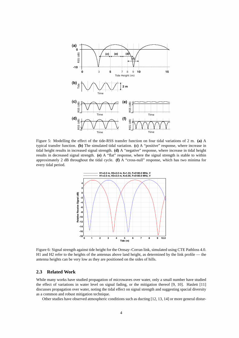
Figure 5: Modelling the effect of the tide-RSS transfer function on four tidal variations of 2 m.(a) Atypical transfer function.(b) The simulated tidal variation.(c) A “positive” response, where increase intidal height results in increased signal strength.(d) A “negative” response, where increase in tidal heightresults in decreased signal strength.(e) A “flat” response, where the signal strength is stable to withinapproximately 2 dB throughout the tidal cycle.(f) A “cross-null” response, which has two minima forevery tidal period.
Figure 6: Signal strength against tide height for the Ornsay–Corran link, simulated using CTE Pathloss 4.0.H1 and H2 refer to the heights of the antennas above land height, as determined by the link profile — theantenna heights can be very low as they are positioned on the sides of hills.
2.3 Related Work
While many works have studied propagation of microwaves overwater, only a small number have studiedthe effect of variations in water level on signal fading, or the mitigation thereof [9, 10]. Haslett [11]discusses propagation over water, noting the tidal effect on signal strength and suggesting spacial diversityas a common and robust mitigation technique.
Other studies have observed atmospheric conditions such asducting [12, 13, 14] or more general distur-
4

Figure 7: Path loss simulated using CTE Pathloss 4.0 for varying height of the Ornsay antenna on theOrnsay–Corran link. The graph shows that nulls occur approximately every 20 m.
bances at altitude [15]. Extreme conditions over water can have a radical effect. At low altitudes above thewater surface the pressure gradient can invert [12, 13, 14] causing ducting. When ducting occurs, multiplerays may reach the receiver after several reflections. The phase of the arriving rays is difficult to predict,and the two-ray model becomes invalid. However, ducting is more likely to occur in some climates than inothers, and has not been observed to date in the Tegola network.
3 Solution Approaches
In this section, we present our proposed frequency diversity based technique for countering tidal fading.We begin by discussing the commonly employed spacial diversity solution to motivate our approach.
3.1 Spacial Diversity
Based on our discussion in Section 2, we know that multipath interference at the receiver changes with theheight of the tide as a result of phase changes between the direct and reflected rays, causing nulls whenboth rays are out of phase by 180◦. In fact, the interference pattern is dependent on the relative heightdifference between antenna heights and water level (tide height) at any given point in time. Figure 7 showsthis relationship for the Ornsay–Corran link for three different tide heights (with respect to the sea level) byvarying the antenna height (with respect to the ground level) at Ornsay (assuming it is the receiver). Fromthis figure, we can make a few observations.
Firstly, one could identify an antenna height at the receiver for a given height of the reflecting plane soas to avoid nulls.
Secondly, when the level of the reflecting plane varies, as isthe case with tidal water, any specificantenna height will experience a null at some point in the tidal cycle.
Thirdly, the tide height changes merely have the effect of the shifting the signal strength versus an-tenna height curve along the horizontal axis — separation between nulls and their depth remain practicallyunchanged.
Finally, the depth of the nulls reduces with the antenna height, which suggests that links with antennasmounted close to the water level are more severely affected by tidal fading.
The commonly used spacial diversity solution to mitigate tidal fading exploits the combined effectof antenna height and tide height on the received signal strength. Specifically, the idea is based on thethird observation above, using two receiving antennas vertically separated by a distance equal to half theseparation between the nulls. This ensures that both antennas do not ever experience a null at the same
5

Figure 8: Simulated tidal fading when operating at 5180MHz and 5825MHz for the Ornsay–Corran linkusing CTE Pathloss 4.0. The fading that would be experiencedby a slow frequency hopping system usingthese two frequencies is also shown.
time. As an example, for the Ornsay–Corran link the verticalantenna separation in a spacial diversitysystem would be around 10m as the null separation is approximately 20m.
While spacial diversity is a robust and popular solution, it has a couple of major drawbacks in terms ofdeployment complexity and cost, especially from the perspective of community deployed wireless networksin rural areas.
Firstly, employing spacial diversity requires accurate measurement, planning and tools in order to de-termine the appropriate antenna separation. These may not be readily available to a community looking toinstall an over-water link.
The second antenna (dish) also substantially increases theoverall cost of the installation. For commu-nity installations, the antenna can be among the most expensive pieces of equipment.
Additionally, the cost of the mast increases rapidly with respect to mast height [16]. A single antennacan be easily and inexpensively mounted just a few metres above the ground, but the cost and complicationof installing a mast for an additional 10m-spaced diversityantenna will be much greater.
3.2 Our Proposal: Slow Frequency Hopping
Our proposal, termed Slow Frequency Hopping (SFH), exploits the frequency dependence of the two-raymodel by switching channels (frequencies) to avoid nulls. The two-ray model is frequency dependentbecause the amplitude of the received signal is governed by the phase difference between the direct andindirect rays. As the frequency increases, the wavelength decreases, and so the phase difference will changeas well. Thus, while for one frequency the two rays may be 180◦ out of phase resulting in a null, at anotherfrequency the two rays will be in phase.
Figure 8 shows potential gains from our SFH proposal, again using the Ornsay–Corran link in theTegola network as an example. For instance, when operating at 5.825 GHz, reflections from a tide heightof 3.6 m would cause a 16 dB fade. Hopping to 5.180 GHz would instead provide a 4-5 dB enhancement tosignal strength due to constructive interference, a net improvement of more than 20dB. The heavy dashedline shows that an optimal frequency hopping scheme using just these two frequencies would preventsignal degradation due to tidal fading altogether for tidesbetween 0 and 9.4 m on the Ornsay–Corranlink. The ideal frequency separation for this link (where nulls at one frequency are maxima at the other)is approximately 800MHz. Hopping between more than two frequencies is expected to provide furtherimprovement by delivering the 4-5 dB enhancement over a wider range of tide heights.
Crucially, the SFH technique does not require any additional hardware. The technique can be imple-mented solely in software by relying upon channel switchingfeatures that already exist in virtually all
6
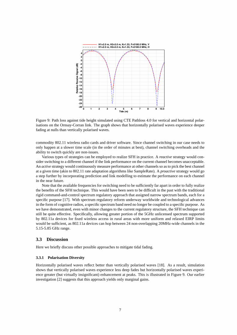
Figure 9: Path loss against tide height simulated using CTE Pathloss 4.0 for vertical and horizontal polar-isations on the Ornsay-Corran link. The graph shows that horizontally polarised waves experience deeperfading at nulls than vertically polarised waves.
commodity 802.11 wireless radio cards and driver software.Since channel switching in our case needs toonly happen at a slower time scale (in the order of minutes at best), channel switching overheads and theability to switch quickly are non-issues.
Various types of strategies can be employed to realize SFH inpractice. Areactivestrategy would con-sider switching to a different channel if the link performance on the current channel becomes unacceptable.An activestrategy would continuously measure performance at other channels so as to pick the best channelat a given time (akin to 802.11 rate adaptation algorithms like SampleRate). Aproactivestrategy would goa step further by incorporating prediction and link modelling to estimate the performance on each channelin the near future.
Note that the available frequencies for switching need to besufficiently far apart in order to fully realizethe benefits of the SFH technique. This would have been seen tobe difficult in the past with the traditionalrigid command-and-control spectrum regulatory approach that assigned narrow spectrum bands, each for aspecific purpose [17]. With spectrum regulatory reform underway worldwide and technological advancesin the form of cognitive radios, a specific spectrum band needno longer be coupled to a specific purpose. Aswe have demonstrated, even with minor changes to the currentregulatory structure, the SFH technique canstill be quite effective. Specifically, allowing greater portion of the 5GHz unlicensed spectrum supportedby 802.11a devices for fixed wireless access in rural areas with more uniform and relaxed EIRP limitswould be sufficient, as 802.11a devices can hop between 24 non-overlapping 20MHz-wide channels in the5.15-5.85 GHz range.
3.3 Discussion
Here we briefly discuss other possible approaches to mitigate tidal fading.
3.3.1 Polarisation Diversity
Horizontally polarised waves reflect better than vertically polarised waves [18]. As a result, simulationshows that vertically polarised waves experience less deepfades but horizontally polarised waves experi-ence greater (but virtually insignificant) enhancement at peaks. This is illustrated in Figure 9. Our earlierinvestigation [2] suggests that this approach yields only marginal gains.
7

3.3.2 Circular Polarisation
Helical antennas operating in axial mode can be used to transmit circularly polarised (CP) waves. CP maybe either left-hand polarised or right-hand polarised. Helical antennas are receptive to CP waves with thesame handedness, but reject CP waves of the wrong handednesswith a significant ratio. This effect can beexploited in order to reject reflections — after reflection the handedness of a CP wave is reversed [18]. Thismeans that a right-handed CP wave will become a left-handed CP wave after reflection, and will thus berejected by the receiving antenna. Preliminary experimental results [19] appear to corroborate this theory.
A circular polarisation based approach, however, has some limitations: CP antennas for frequencies inthe 5GHz range are less compact than their linearly polarised counterparts for the same gain (equivalently,beam width) as the beam width must be traded off against the length of the helix. Commercially availablehelical antennas, while being compact and with similar cost, have comparatively wide beam widths and loweffective gain, thus making them unsuitable for long-distance wireless links (around 10km). Additionally,CP antennas are typically limited to operating effectivelyin a narrow frequency range of around 100MHz.
3.3.3 MIMO
The 802.11n (MIMO) standard [20] specifies two spatial diversity modes — Transmit Beamforming (TxBF)and Space-Time Block Coding (STBC). These modes may be able to mitigate tidal fading effects, but theirbenefits remain unproven. for long-distance point-to-point links in rural environments.
In the future, we plan to study the effectiveness of 802.11n in comparison with the proposed SFHtechnique.
4 Conclusions
4.1 Preliminary Findings
Our findings show that there is a significant relation betweentide height and signal strength for over-seawireless links, that deep fades due to tidal effects can havea significant impact on link quality, and thatunlike over-land rural networks, tidal effects may be the primary cause of performance degradation.
We propose a software-only solution called slow frequency hopping to effectively mitigate tidal fadeswithout requiring expert knowledge from network installers and maintainers. Our proposed solution canbe implemented using features that already exist in all 802.11 devices, and is a cost-effective alternative tothe industry solution based on spacial diversity.
4.2 Planned Work
We plan to continue to collect data from links in the Tegola network in order to verify conclusions drawnfrom modelling and simulation in this paper. This data will be correlated with available weather informationin order to better characterise the effect of adverse conditions such as rain and humidity on the accuracy ofthe geometric model.
More crucially, we plan to develop a prototype implementation of the proposed slow frequency hoppingmitigation technique and conduct a measurement-based evaluation on the Tegola network to experimentallyvalidate our simulation results and compare with the spacial diversity solution. We also plan to design,implement and evaluate reactive, active and proactive frequency hopping strategies.
Acknowledgments
This work was supported in part by The Royal Society. We wouldlike to thank Peter Buneman and MinoBernardi for helpful discussions, and British Oceanographic Data Centre (BODC) for the tidal data.
8
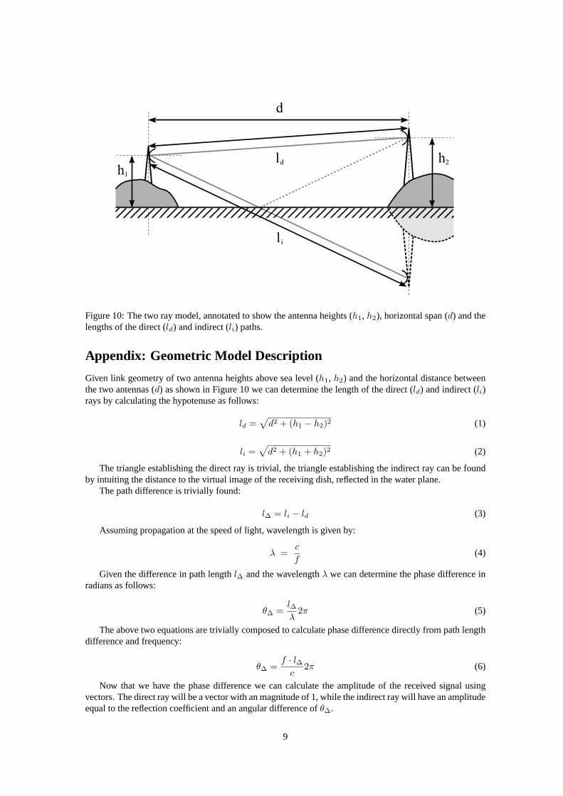
Figure 10: The two ray model, annotated to show the antenna heights (h1, h2), horizontal span (d) and thelengths of the direct (ld) and indirect (li) paths.
Appendix: Geometric Model Description
Given link geometry of two antenna heights above sea level (h1, h2) and the horizontal distance betweenthe two antennas (d) as shown in Figure 10 we can determine the length of the direct (ld) and indirect (li)rays by calculating the hypotenuse as follows:
ld =√
d2 + (h1 − h2)2 (1)
li =√
d2 + (h1 + h2)2 (2)
The triangle establishing the direct ray is trivial, the triangle establishing the indirect ray can be foundby intuiting the distance to the virtual image of the receiving dish, reflected in the water plane.
The path difference is trivially found:
l∆ = li − ld (3)
Assuming propagation at the speed of light, wavelength is given by:
λ =c
f(4)
Given the difference in path lengthl∆ and the wavelengthλ we can determine the phase difference inradians as follows:
θ∆ =l∆
λ2π (5)
The above two equations are trivially composed to calculatephase difference directly from path lengthdifference and frequency:
θ∆ =f · l∆
c2π (6)
Now that we have the phase difference we can calculate the amplitude of the received signal usingvectors. The direct ray will be a vector with an magnitude of 1, while the indirect ray will have an amplitudeequal to the reflection coefficient and an angular differenceof θ∆.
9

The magnitude of the sum of two arbitrary vectors is given by:
|c| =
√
(|a| cos θa + |b| cos θb)2
+ (|a| sin θa + |b| sin θb)2 (7)
However, for the direct raya, |a| = 1 andθa = 0, so when calculating the relative amplitude of thereceived signal compared to propagation in free spaceArx given a phase differenceθ∆ and a reflectioncoefficientΓ the above equation simplifies to:
Arx =√
(1 + Γcosθ∆)2 + (Γsinθ∆)2 (8)
WhenArx is 1, the received signal strength (RSS) is identical to the expected received signal strengthin free space. WhenArx is less than 1, the RSS will be diminished. A null occurs whenArx approaches0. Signal enhancement occurs whenArx increases above 1.
For convenience,Arx can be expressed in dB by taking the logarithm and multiplying by 10. Thisallows easy calculation in link budget analysis by indicating the “depth of the fade” that the link willexperience.
Tide is easily factored into this model by recomputing with changing values forh1 andh2. We simplyobserve that as the tide rises, the antenna height with respect to sea level effectively decreases.
References
[1] Wireless Networking in the Developing World. http://wndw.net/index.html, Dec 2007. Second Edi-tion.
[2] G Bernardi, P Buneman, and M Marina. Tegola Tiered Mesh Network Testbed in Rural Scotland.In Proc. ACM MobiCom 2008 Workshop on Wireless Networks and Systems for Developing Regions(WiNS-DR’08), Sep 2008.
[3] A Sheth, S Nedevschi, R Patra, S Surana, E Brewer, and L Subramanian. Packet Loss Characterizationin WiFi-based Long Distance Networks. InProc. IEEE Infocom, 2007.
[4] D Gokhale, S Sen, K Chebrolu, and B Raman. On the Feasibility of the Link Abstraction in (Rural)Mesh Networks. InProc. IEEE Infocom, 2008.
[5] West Highland Free Press. ConCom: Growing Tide of Dissatisfaction, Feb 2008.
[6] Pathloss 4.0, Oct 2009. (Online) http://www.pathloss.com/p4/index.html.
[7] P Bahl, R Chandra, and J Dunagan. SSCH: Slotted Seeded Channel Hopping for Capacity Improve-ment in IEEE 802.11 Ad-Hoc Wireless Networks. InProc. ACM MobiCom, 2004.
[8] P Rice and A Longley. Prediction Of Tropospheric Radio Transmission Loss Over Irregular Terrain.A Computer Method, Jan 1968.
[9] A LaGrone, A Straiton, and H Smith. Synthesis Of Radio Signals on Overwater Paths.IRE Transac-tions on Antennas and Propagation, 3(2):48–52, 1955.
[10] N Fuke, K Sugiyama, and H Shinonaga. Long-range OverseaWireless Network Using 2.4 GHzWireless LAN Installation and Performance. InProc. ICCCN, 2003.
[11] C Haslett.Essentials of Radio Wave Propagation, chapter 4 Reflection, scatter and penetration, pages95–98. Cambridge University Press, 2008.
[12] J McPetrie, B Starnecki, and H Jarkowski. Oversea Propagation on Wavelengths of 3 and 9 Centime-ters. InProceedings of the IRE, Jan 1949.
[13] T Inoue and T Akiyama. Propagation Characteristics on Line-of-sight Over-sea Paths in Japan.IEEETrans. Antennas Propag., 22(4):557–565, 1974.
10
[14] D Siddle, E Warrington, and S Gunashekar. Signal Strength Variations at 2 GHz for Three Sea Pathsin the British Channel Islands: Observations and Statistical Analysis.Radio Sci., 42(4):RS4019, Aug2007.
[15] W Lam and A Webster. Microwave Propagation on Two Line-of-sight Oversea Paths.IEEE Trans.Antennas Propag., 33(5):510–516, 1985.
[16] S Sen and B Raman. Long Distance Wireless Mesh Network Planning: Problem Formulation andSolution. InProc. World Wide Web (WWW) Conference, 2007.
[17] M Cave, C Doyle, and W Webb.Essentials of Modern Spectrum Management. Cambridge UniversityPress, 2007.
[18] S Saunders and A Aragon-Zavala. Antennas And Propagation For Wireless Communication Systems,chapter 3.2.3 Typical Reflection and Transmission Coefficients, page 546. John Wiley & Sons, Ltd,second edition, 2007.
[19] J Bauer, Sep 2009. private communication.
[20] Y Xiao. IEEE 802.11n: Enhancements For Higher Throughput in Wireless LANs. IEEE WirelessCommun. Mag., 12(6):8291, Dec. 2005.
11