schedule of classified roads and state and regional roads
TRANSCRIPT

Schedule of Classified Roads and Unclassified Regional Roads
Changes to this document are captured in ‘Recently Gazetted Changes’: http://www.rms.nsw.gov.au/business-industry/partners-suppliers/lgr/arrangements-councils/road-classification.html Summary Roads and Maritime Services (RMS) is required under the Roads Act 1993 s163 (4) to keep a record of all classified roads. To satisfy this commitment, this document contains a record of the roads classified under sections 46, 47, 50 or 51 of the Roads Act 1993 that have a Legal Class of Highway, Main Road, Secondary Road or Tourist Road - as legally described by Declaration Order in the Government Gazette. To manage the extensive network of roads for which council is responsible under the Roads Act 1993, RMS in partnership with local government established an administrative framework of State, Regional, and Local Road categories. State Roads are managed and financed by RMS and Regional and Local Roads are managed and financed by councils. Regional Roads perform an intermediate function between the main arterial network of State Roads and council controlled Local Roads. Due to their network significance RMS provides financial assistance to councils for the management of their Regional Roads. The Regional Road category comprises two sub-categories: those Regional Roads that are classified pursuant to the Roads Act 1993, and those Regional Roads that are unclassified. For completeness, the Schedule includes unclassified Regional Roads. Local Roads are unclassified roads and therefore are not included in the Schedule. The recently introduced alpha-numeric route numbering (MAB) system used for wayfinding purposes in NSW does not directly relate to the legal classification of roads and has not been incorporated into this Schedule. The Schedule notes the administrative class (either State or Regional Road) for classified roads. Where a classified road comprises sections of State Road and Regional Road, a description of each section is shown. Note: The declaration of roads with a legal class of Freeway, Controlled Access Road, Tollway or Transitway under sections 48, 49 or 52 of the Roads Act 1993, is usually by reference to cadastral information. These roads are not included in this Schedule. The list below contains only a general description of Freeways, Tollways and Transitways, not the legally declared description of roads in these classes. Note that sections of Highways and Main Roads may have a dual legal classification as Freeway or Controlled Access Road. Key to Numbering System in this Schedule
Classified Roads (pursuant to Road Act 1993 )
Unclassified Roads (pursuant to Administrative Agreement)
Road Number Class Road Number Class
1-31 Highway (HW)
(Previously State Highway (SH))
7000 series Unclassified Regional Roads
51-694 Main Road (MR)
2001-2114 Secondary Road (SR)
4000-4056 Tourist Road (TO)
8001-8011 Transitway (TW)
PREPARED BY PLANNING AND OPERATIONS BRANCH LAST UPDATED APRIL 2017 SF2012/015672 VERSION 11

Page 1
Gazetted Road
Number
Gazetted Name and Description Administrative Category
Most recent Gazettal (Government Gazette
Number and date)
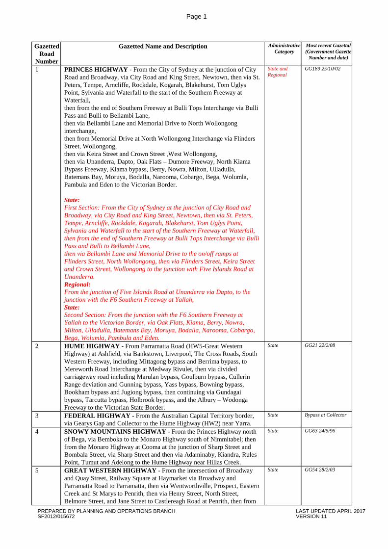
1 PRINCES HIGHWAY - From the City of Sydney at the junction of City Road and Broadway, via City Road and King Street, Newtown, then via St. Peters, Tempe, Arncliffe, Rockdale, Kogarah, Blakehurst, Tom Uglys Point, Sylvania and Waterfall to the start of the Southern Freeway at Waterfall, then from the end of Southern Freeway at Bulli Tops Interchange via Bulli Pass and Bulli to Bellambi Lane, then via Bellambi Lane and Memorial Drive to North Wollongong interchange, then from Memorial Drive at North Wollongong Interchange via Flinders Street, Wollongong, then via Keira Street and Crown Street ,West Wollongong, then via Unanderra, Dapto, Oak Flats – Dumore Freeway, North Kiama Bypass Freeway, Kiama bypass, Berry, Nowra, Milton, Ulladulla, Batemans Bay, Moruya, Bodalla, Narooma, Cobargo, Bega, Wolumla, Pambula and Eden to the Victorian Border. State: First Section: From the City of Sydney at the junction of City Road and Broadway, via City Road and King Street, Newtown, then via St. Peters, Tempe, Arncliffe, Rockdale, Kogarah, Blakehurst, Tom Uglys Point, Sylvania and Waterfall to the start of the Southern Freeway at Waterfall, then from the end of Southern Freeway at Bulli Tops Interchange via Bulli Pass and Bulli to Bellambi Lane, then via Bellambi Lane and Memorial Drive to the on/off ramps at Flinders Street, North Wollongong, then via Flinders Street, Keira Street and Crown Street, Wollongong to the junction with Five Islands Road at Unanderra. Regional: From the junction of Five Islands Road at Unanderra via Dapto, to the junction with the F6 Southern Freeway at Yallah, State: Second Section: From the junction with the F6 Southern Freeway at Yallah to the Victorian Border, via Oak Flats, Kiama, Berry, Nowra, Milton, Ulladulla, Batemans Bay, Moruya, Bodalla, Narooma, Cobargo, Bega, Wolumla, Pambula and Eden.
State and Regional
GG189 25/10/02
2 HUME HIGHWAY - From Parramatta Road (HW5-Great Western Highway) at Ashfield, via Bankstown, Liverpool, The Cross Roads, South Western Freeway, including Mittagong bypass and Berrima bypass, to Mereworth Road Interchange at Medway Rivulet, then via divided carriageway road including Marulan bypass, Goulburn bypass, Cullerin Range deviation and Gunning bypass, Yass bypass, Bowning bypass, Bookham bypass and Jugiong bypass, then continuing via Gundagai bypass, Tarcutta bypass, Holbrook bypass, and the Albury – Wodonga Freeway to the Victorian State Border.
State GG21 22/2/08
3 FEDERAL HIGHWAY - From the Australian Capital Territory border, via Gearys Gap and Collector to the Hume Highway (HW2) near Yarra.
State Bypass at Collector
4 SNOWY MOUNTAINS HIGHWAY - From the Princes Highway north of Bega, via Bemboka to the Monaro Highway south of Nimmitabel; then from the Monaro Highway at Cooma at the junction of Sharp Street and Bombala Street, via Sharp Street and then via Adaminaby, Kiandra, Rules Point, Tumut and Adelong to the Hume Highway near Hillas Creek.
State GG63 24/5/96
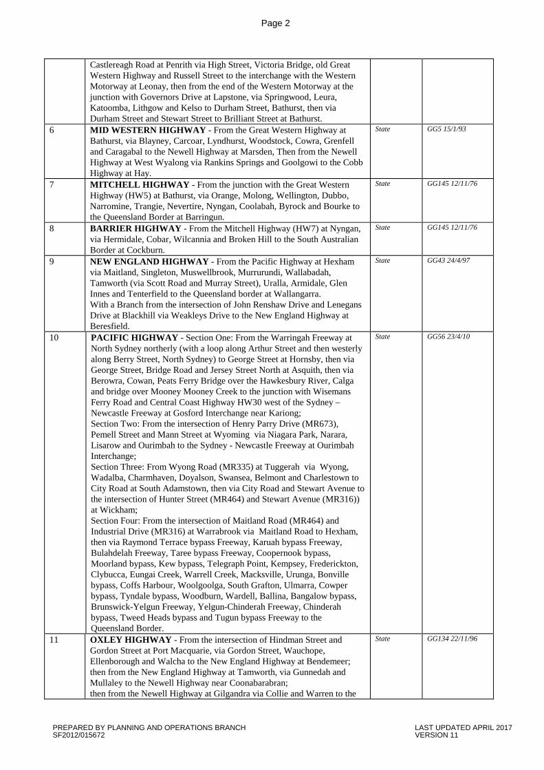
5 GREAT WESTERN HIGHWAY - From the intersection of Broadway and Quay Street, Railway Square at Haymarket via Broadway and Parramatta Road to Parramatta, then via Wentworthville, Prospect, Eastern Creek and St Marys to Penrith, then via Henry Street, North Street, Belmore Street, and Jane Street to Castlereagh Road at Penrith, then from
State GG54 28/2/03
PREPARED BY PLANNING AND OPERATIONS BRANCH LAST UPDATED APRIL 2017 SF2012/015672 VERSION 11
Page 2
Castlereagh Road at Penrith via High Street, Victoria Bridge, old Great Western Highway and Russell Street to the interchange with the Western Motorway at Leonay, then from the end of the Western Motorway at the junction with Governors Drive at Lapstone, via Springwood, Leura, Katoomba, Lithgow and Kelso to Durham Street, Bathurst, then via Durham Street and Stewart Street to Brilliant Street at Bathurst.
6 MID WESTERN HIGHWAY - From the Great Western Highway at Bathurst, via Blayney, Carcoar, Lyndhurst, Woodstock, Cowra, Grenfell and Caragabal to the Newell Highway at Marsden, Then from the Newell Highway at West Wyalong via Rankins Springs and Goolgowi to the Cobb Highway at Hay.
State GG5 15/1/93
7 MITCHELL HIGHWAY - From the junction with the Great Western Highway (HW5) at Bathurst, via Orange, Molong, Wellington, Dubbo, Narromine, Trangie, Nevertire, Nyngan, Coolabah, Byrock and Bourke to the Queensland Border at Barringun.
State GG145 12/11/76
8 BARRIER HIGHWAY - From the Mitchell Highway (HW7) at Nyngan, via Hermidale, Cobar, Wilcannia and Broken Hill to the South Australian Border at Cockburn.
State GG145 12/11/76
9 NEW ENGLAND HIGHWAY - From the Pacific Highway at Hexham via Maitland, Singleton, Muswellbrook, Murrurundi, Wallabadah, Tamworth (via Scott Road and Murray Street), Uralla, Armidale, Glen Innes and Tenterfield to the Queensland border at Wallangarra. With a Branch from the intersection of John Renshaw Drive and Lenegans Drive at Blackhill via Weakleys Drive to the New England Highway at Beresfield.
State GG43 24/4/97
10 PACIFIC HIGHWAY - Section One: From the Warringah Freeway at North Sydney northerly (with a loop along Arthur Street and then westerly along Berry Street, North Sydney) to George Street at Hornsby, then via George Street, Bridge Road and Jersey Street North at Asquith, then via Berowra, Cowan, Peats Ferry Bridge over the Hawkesbury River, Calga and bridge over Mooney Mooney Creek to the junction with Wisemans Ferry Road and Central Coast Highway HW30 west of the Sydney – Newcastle Freeway at Gosford Interchange near Kariong; Section Two: From the intersection of Henry Parry Drive (MR673), Pemell Street and Mann Street at Wyoming via Niagara Park, Narara, Lisarow and Ourimbah to the Sydney - Newcastle Freeway at Ourimbah Interchange; Section Three: From Wyong Road (MR335) at Tuggerah via Wyong, Wadalba, Charmhaven, Doyalson, Swansea, Belmont and Charlestown to City Road at South Adamstown, then via City Road and Stewart Avenue to the intersection of Hunter Street (MR464) and Stewart Avenue (MR316)) at Wickham; Section Four: From the intersection of Maitland Road (MR464) and Industrial Drive (MR316) at Warrabrook via Maitland Road to Hexham, then via Raymond Terrace bypass Freeway, Karuah bypass Freeway, Bulahdelah Freeway, Taree bypass Freeway, Coopernook bypass, Moorland bypass, Kew bypass, Telegraph Point, Kempsey, Frederickton, Clybucca, Eungai Creek, Warrell Creek, Macksville, Urunga, Bonville bypass, Coffs Harbour, Woolgoolga, South Grafton, Ulmarra, Cowper bypass, Tyndale bypass, Woodburn, Wardell, Ballina, Bangalow bypass, Brunswick-Yelgun Freeway, Yelgun-Chinderah Freeway, Chinderah bypass, Tweed Heads bypass and Tugun bypass Freeway to the Queensland Border.
State GG56 23/4/10
11 OXLEY HIGHWAY - From the intersection of Hindman Street and Gordon Street at Port Macquarie, via Gordon Street, Wauchope, Ellenborough and Walcha to the New England Highway at Bendemeer; then from the New England Highway at Tamworth, via Gunnedah and Mullaley to the Newell Highway near Coonabarabran; then from the Newell Highway at Gilgandra via Collie and Warren to the
State GG134 22/11/96
PREPARED BY PLANNING AND OPERATIONS BRANCH LAST UPDATED APRIL 2017 SF2012/015672 VERSION 11
Page 3
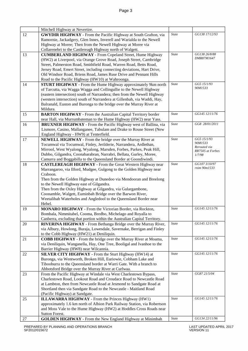
Mitchell Highway at Nevertire. 12 GWYDIR HIGHWAY - From the Pacific Highway at South Grafton, via
Ramornie, Jackadgery, Glen Innes, Inverell and Warialda to the Newell Highway at Moree; Then from the Newell Highway at Moree via Collarenebri to the Castlereagh Highway north of Walgett.
State GG138 17/12/93
13 CUMBERLAND HIGHWAY - From Copeland Street, Hume Highway (HW2) at Liverpool, via Orange Grove Road, Joseph Street, Cambridge Street, Palmerston Road, Smithfield Road, Warren Road, Betts Road, Jersey Road, Emert Street, including connecting deviations, Hart Drive, Old Windsor Road, Briens Road, James Ruse Drive and Pennant Hills Road to the Pacific Highway (HW10) at Wahroonga.
State GG138 26/8/88 DMR87M1647
14 STURT HIGHWAY - From the Hume Highway approximately 9km north of Tarcutta, via Wagga Wagga and Collingullie to the Newell Highway (eastern intersection) south of Narrandera; then from the Newell Highway (western intersection) south of Narrandera at Gillenbah, via Waddi, Hay, Balranald, Euston and Buronga to the bridge over the Murray River at Mildura.
State GG5 15/1/93 90M1533
15 BARTON HIGHWAY - From the Australian Capital Territory border near Hall, via Murrumbateman to the Hume Highway (HW2) near Yass.
State GG145 12/11/76
16 BRUXNER HIGHWAY - From the Pacific Highway west of Ballina, via Lismore, Casino, Mallanganee, Tabulam and Drake to Rouse Street (New England Highway - HW9) at Tenterfield.
State GG8 28/01/2011
17 NEWELL HIGHWAY - From the bridge over the Murray River at Tocumwal via Tocumwal, Finley, Jerilderie, Narrandera, Ardlethan, Mirrool, West Wyalong, Wyalong, Marsden, Forbes, Parkes, Peak Hill, Dubbo, Gilgandra, Coonabarabran, Narrabri, Bellata, Gurley, Moree, Camurra and Boggabilla to the Queensland Border at Goondiwindi.
State GG5 15/1/93 90M1533 Rerouted via RR7505 at Forbes 1/7/98
18 CASTLEREAGH HIGHWAY - From the Great Western Highway near Marrangaroo, via Ilford, Mudgee, Gulgong to the Golden Highway near Craboon. Then from the Golden Highway at Dunedoo via Mendooran and Breelong to the Newell Highway east of Gilgandra. Then from the Oxley Highway at Gilgandra, via Gulargambone, Coonamble, Walgett, Euminbah Bridge over the Barwon River, Weetalibah Waterholes and Angledool to the Queensland Border near Hebel.
State GG107 3/10/97 rnim 90m1533
19 MONARO HIGHWAY - From the Victorian Border, via Rockton, Bombala, Nimmitabel, Cooma, Bredbo, Michelago and Royalla to Canberra, excluding that portion within the Australian Capital Territory.
State GG145 12/11/76
20 RIVERINA HIGHWAY - From Bethanga Bridge over the Murray River, via Albury, Howlong, Buraja, Lowesdale, Savernake, Berrigan and Finley to the Cobb Highway (HW21) at Deniliquin.
State GG145 12/11/76
21 COBB HIGHWAY - From the bridge over the Murray River at Moama, via Deniliquin, Wanganella, Hay, One Tree, Booligal and Ivanhoe to the Barrier Highway (HW8) near Wilcannia.
State GG145 12/11/76
22 SILVER CITY HIGHWAY - From the Sturt Highway (HW14) at Buronga, via Wentworth, Broken Hill, Euriowie, Cobham Lake and Tibooburra to the Queensland border at Warri Gate. With a branch to Abbotsford Bridge over the Murray River at Curlwaa.
State GG145 12/11/76
23 From the Pacific Highway at Windale via West Charlestown Bypass, Charlestown Road, Lookout Road and Croudace Road to Newcastle Road at Lambton, then from Newcastle Road at Jesmond to Sandgate Road at Shortland then via Sandgate Road to the Newcastle - Maitland Road (Pacific Highway) at Sandgate.
State GG87 21/5/04
25 ILLAWARRA HIGHWAY - From the Princes Highway (HW1) approximately 1.6 km north of Albion Park Railway Station, via Robertson and Moss Vale to the Hume Highway (HW2) at Hoddles Cross Roads near Sutton Forest.
State GG145 12/11/76
27 GOLDEN HIGHWAY - From the New England Highway at Minimbah State GG134 22/11/96
PREPARED BY PLANNING AND OPERATIONS BRANCH LAST UPDATED APRIL 2017 SF2012/015672 VERSION 11
Page 4
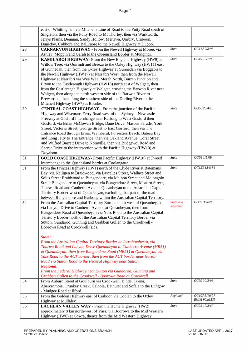
east of Whittingham via Mitchells Line of Road to the Putty Road south of Singleton, then via the Putty Road to Mt Thorley, then via Warkworth, Jerrys Plains, Denman, Sandy Hollow, Merriwa, Uarbry, Craboon, Dunedoo, Cobbora and Ballimore to the Newell Highway at Dubbo.
28 CARNARVON HIGHWAY - From the Newell Highway at Moree, via Ashley, Moppin and Garah to the Queensland Border at Mungindi.
State GG117 7/8/98
29 KAMILAROI HIGHWAY- From the New England Highway (HW9) at Willow Tree, via Quirindi and Breeza to the Oxley Highway (HW11) east of Gunnedah, then from the Oxley Highway at Gunnedah via Boggabri to the Newell Highway (HW17) at Narrabri West, then from the Newell Highway at Narrabri via Wee Waa, Merah North, Burren Junction and Cryon to the Castlereagh Highway (HW18) north east of Walgett, then from the Castlereagh Highway at Walgett, crossing the Barwon River near Walgett, then along the north western side of the Barwon River to Brewarrina, then along the southern side of the Darling River to the Mitchell Highway (HW7) at Bourke.
State GG19 12/2/99
30 CENTRAL COAST HIGHWAY - From the junction of the Pacific Highway and Wisemans Ferry Road west of the Sydney – Newcastle Freeway at Gosford Interchange near Kariong to West Gosford then Gosford, via Brian McGowan Bridge, Dane Drive, Masons Parade, York Street, Victoria Street, George Street to East Gosford, then via The Entrance Road through Erina, Wamberal, Forresters Beach, Bateau Bay and Long Jetty to The Entrance, then via Oakland Avenue, Coral Street and Wilfred Barrett Drive to Noraville, then via Budgewoi Road and Scenic Drive to the intersection with the Pacific Highway (HW10) at Doyalson.
State GG56 23/4/10
31 GOLD COAST HIGHWAY- From Pacific Highway (HW10) at Tweed Interchange to the Queensland border at Coolangatta.
State GG66 1/5/09
51 From the Princes Highway (HW1) north of the Clyde River at Batemans Bay, via Nelligen to Braidwood, via Lascelles Street, Wallace Street and Solus Street Braidwood to Bungendore, via Malbon Street and Molongolo Street Bungendore to Queanbeyan, via Bungendore Street, Monaro Street, Tharwa Road and Canberra Avenue Queanbeyan to the Australian Capital Territory Border west of Queanbeyan, excluding that part of the road between Bungendore and Burbong within the Australian Capital Territory.
State GG123 18/8/84
52 From the Australian Capital Territory Border south-west of Queanbeyan via Lanyon Drive to Canberra Avenue at Queanbeyan; then from Bungendore Road at Queanbeyan via Yass Road to the Australian Capital Territory Border north of the Australian Capital Territory Border via Sutton, Gundaroo, Gunning and Grabben Gullen to the Crookwell - Boorowa Road at Crookwell.(sic). State: From the Australian Capital Territory Border at Jerrabomberra, via Tharwa Road and Lanyon Drive Queanbeyan to Canberra Avenue (MR51) at Queanbeyan; then from Bungendore Road (MR51) at Queanbeyan via Yass Road to the ACT border, then from the ACT border near Norton Road via Sutton Road to the Federal Highway near Sutton. Regional: From the Federal Highway near Sutton via Gundaroo, Gunning and Grabben Gullen to the Crookwell - Boorowa Road at Crookwell.
State and Regional
GG99 30/8/96
54 From Auburn Street at Goulburn via Crookwell, Binda, Tuena, Abercrombie, Trunkey Creek, Caloola, Bathurst and Sofala to the Lithgow - Mudgee Road at Ilford.
State GG99 30/8/96
55 From the Golden Highway east of Craboon via Coolah to the Oxley Highway at Mullaley.
Regional GG107 3/10/97 RNIM 90m1533
56 LACHLAN VALLEY WAY - From the Hume Highway (HW2) approximately 8 km north-west of Yass, via Boorowa to the Mid Western Highway (HW6) at Cowra, thence from the Mid Western Highway
State GG25 17/3/67
PREPARED BY PLANNING AND OPERATIONS BRANCH LAST UPDATED APRIL 2017 SF2012/015672 VERSION 11
Page 5
approximately 5 km west of Cowra to the Newell Highway (HW17) at Forbes.
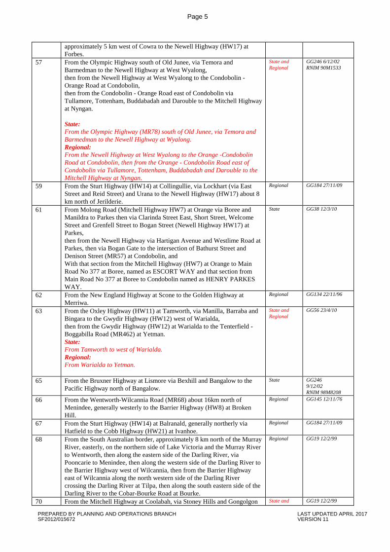
57 From the Olympic Highway south of Old Junee, via Temora and Barmedman to the Newell Highway at West Wyalong, then from the Newell Highway at West Wyalong to the Condobolin -Orange Road at Condobolin, then from the Condobolin - Orange Road east of Condobolin via Tullamore, Tottenham, Buddabadah and Darouble to the Mitchell Highway at Nyngan. State: From the Olympic Highway (MR78) south of Old Junee, via Temora and Barmedman to the Newell Highway at Wyalong. Regional: From the Newell Highway at West Wyalong to the Orange -Condobolin Road at Condobolin, then from the Orange - Condobolin Road east of Condobolin via Tullamore, Tottenham, Buddabadah and Darouble to the Mitchell Highway at Nyngan.
State and Regional
GG246 6/12/02 RNIM 90M1533
59 From the Sturt Highway (HW14) at Collingullie, via Lockhart (via East Street and Reid Street) and Urana to the Newell Highway (HW17) about 8 km north of Jerilderie.
Regional GG184 27/11/09
61 From Molong Road (Mitchell Highway HW7) at Orange via Boree and Manildra to Parkes then via Clarinda Street East, Short Street, Welcome Street and Grenfell Street to Bogan Street (Newell Highway HW17) at Parkes, then from the Newell Highway via Hartigan Avenue and Westlime Road at Parkes, then via Bogan Gate to the intersection of Bathurst Street and Denison Street (MR57) at Condobolin, and With that section from the Mitchell Highway (HW7) at Orange to Main Road No 377 at Boree, named as ESCORT WAY and that section from Main Road No 377 at Boree to Condobolin named as HENRY PARKES WAY.
State GG38 12/3/10
62 From the New England Highway at Scone to the Golden Highway at Merriwa.
Regional GG134 22/11/96
63 From the Oxley Highway (HW11) at Tamworth, via Manilla, Barraba and Bingara to the Gwydir Highway (HW12) west of Warialda, then from the Gwydir Highway (HW12) at Warialda to the Tenterfield - Boggabilla Road (MR462) at Yetman. State: From Tamworth to west of Warialda. Regional: From Warialda to Yetman.
State and Regional
GG56 23/4/10
65 From the Bruxner Highway at Lismore via Bexhill and Bangalow to the Pacific Highway north of Bangalow.
State GG246 9/12/02 RNIM 98M8208
66 From the Wentworth-Wilcannia Road (MR68) about 16km north of Menindee, generally westerly to the Barrier Highway (HW8) at Broken Hill.
Regional GG145 12/11/76
67 From the Sturt Highway (HW14) at Balranald, generally northerly via Hatfield to the Cobb Highway (HW21) at Ivanhoe.
Regional GG184 27/11/09
68 From the South Australian border, approximately 8 km north of the Murray River, easterly, on the northern side of Lake Victoria and the Murray River to Wentworth, then along the eastern side of the Darling River, via Pooncarie to Menindee, then along the western side of the Darling River to the Barrier Highway west of Wilcannia, then from the Barrier Highway east of Wilcannia along the north western side of the Darling River crossing the Darling River at Tilpa, then along the south eastern side of the Darling River to the Cobar-Bourke Road at Bourke.
Regional GG19 12/2/99
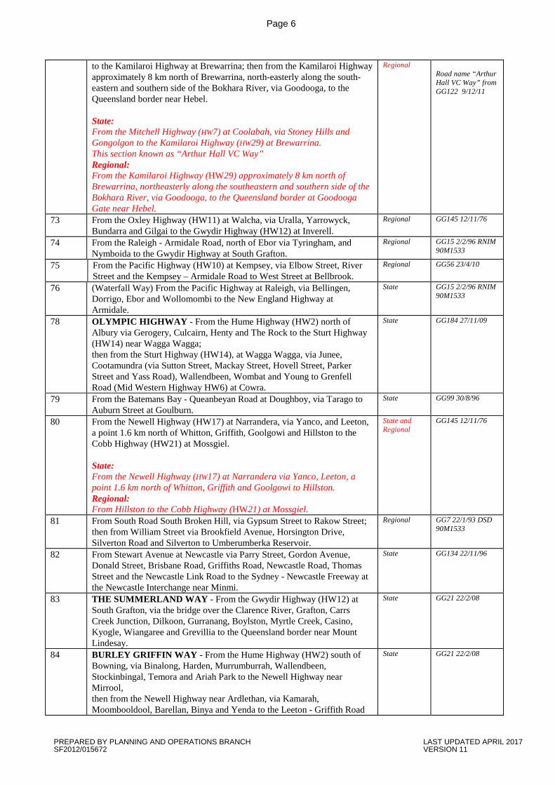
70 From the Mitchell Highway at Coolabah, via Stoney Hills and Gongolgon State and GG19 12/2/99
PREPARED BY PLANNING AND OPERATIONS BRANCH LAST UPDATED APRIL 2017 SF2012/015672 VERSION 11
Page 6
to the Kamilaroi Highway at Brewarrina; then from the Kamilaroi Highway approximately 8 km north of Brewarrina, north-easterly along the south-eastern and southern side of the Bokhara River, via Goodooga, to the Queensland border near Hebel. State: From the Mitchell Highway (HW7) at Coolabah, via Stoney Hills and Gongolgon to the Kamilaroi Highway (HW29) at Brewarrina. This section known as “Arthur Hall VC Way” Regional: From the Kamilaroi Highway (HW29) approximately 8 km north of Brewarrina, northeasterly along the southeastern and southern side of the Bokhara River, via Goodooga, to the Queensland border at Goodooga Gate near Hebel.
Regional Road name “Arthur Hall VC Way” from GG122 9/12/11
73 From the Oxley Highway (HW11) at Walcha, via Uralla, Yarrowyck, Bundarra and Gilgai to the Gwydir Highway (HW12) at Inverell.
Regional GG145 12/11/76
74 From the Raleigh - Armidale Road, north of Ebor via Tyringham, and Nymboida to the Gwydir Highway at South Grafton.
Regional GG15 2/2/96 RNIM 90M1533
75 From the Pacific Highway (HW10) at Kempsey, via Elbow Street, River Street and the Kempsey – Armidale Road to West Street at Bellbrook.
Regional GG56 23/4/10
76 (Waterfall Way) From the Pacific Highway at Raleigh, via Bellingen, Dorrigo, Ebor and Wollomombi to the New England Highway at Armidale.
State GG15 2/2/96 RNIM 90M1533
78 OLYMPIC HIGHWAY - From the Hume Highway (HW2) north of Albury via Gerogery, Culcairn, Henty and The Rock to the Sturt Highway (HW14) near Wagga Wagga; then from the Sturt Highway (HW14), at Wagga Wagga, via Junee, Cootamundra (via Sutton Street, Mackay Street, Hovell Street, Parker Street and Yass Road), Wallendbeen, Wombat and Young to Grenfell Road (Mid Western Highway HW6) at Cowra.
State GG184 27/11/09
79 From the Batemans Bay - Queanbeyan Road at Doughboy, via Tarago to Auburn Street at Goulburn.
State GG99 30/8/96
80 From the Newell Highway (HW17) at Narrandera, via Yanco, and Leeton, a point 1.6 km north of Whitton, Griffith, Goolgowi and Hillston to the Cobb Highway (HW21) at Mossgiel. State: From the Newell Highway (HW17) at Narrandera via Yanco, Leeton, a point 1.6 km north of Whitton, Griffith and Goolgowi to Hillston. Regional: From Hillston to the Cobb Highway (HW21) at Mossgiel.
State and Regional
GG145 12/11/76
81 From South Road South Broken Hill, via Gypsum Street to Rakow Street; then from William Street via Brookfield Avenue, Horsington Drive, Silverton Road and Silverton to Umberumberka Reservoir.
Regional GG7 22/1/93 DSD 90M1533
82 From Stewart Avenue at Newcastle via Parry Street, Gordon Avenue, Donald Street, Brisbane Road, Griffiths Road, Newcastle Road, Thomas Street and the Newcastle Link Road to the Sydney - Newcastle Freeway at the Newcastle Interchange near Minmi.
State GG134 22/11/96
83 THE SUMMERLAND WAY - From the Gwydir Highway (HW12) at South Grafton, via the bridge over the Clarence River, Grafton, Carrs Creek Junction, Dilkoon, Gurranang, Boylston, Myrtle Creek, Casino, Kyogle, Wiangaree and Grevillia to the Queensland border near Mount Lindesay.
State GG21 22/2/08
84 BURLEY GRIFFIN WAY - From the Hume Highway (HW2) south of Bowning, via Binalong, Harden, Murrumburrah, Wallendbeen, Stockinbingal, Temora and Ariah Park to the Newell Highway near Mirrool, then from the Newell Highway near Ardlethan, via Kamarah, Moombooldool, Barellan, Binya and Yenda to the Leeton - Griffith Road
State GG21 22/2/08
PREPARED BY PLANNING AND OPERATIONS BRANCH LAST UPDATED APRIL 2017 SF2012/015672 VERSION 11
Page 7
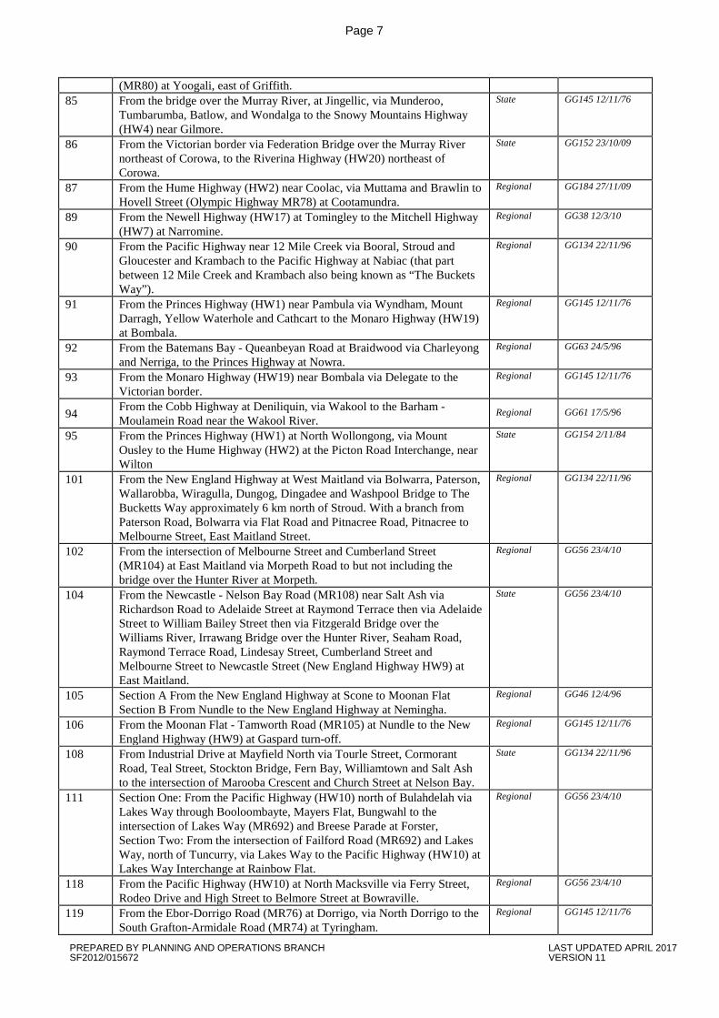
(MR80) at Yoogali, east of Griffith. 85 From the bridge over the Murray River, at Jingellic, via Munderoo,
Tumbarumba, Batlow, and Wondalga to the Snowy Mountains Highway (HW4) near Gilmore.
State GG145 12/11/76
86 From the Victorian border via Federation Bridge over the Murray River northeast of Corowa, to the Riverina Highway (HW20) northeast of Corowa.
State GG152 23/10/09
87 From the Hume Highway (HW2) near Coolac, via Muttama and Brawlin to Hovell Street (Olympic Highway MR78) at Cootamundra.
Regional GG184 27/11/09
89 From the Newell Highway (HW17) at Tomingley to the Mitchell Highway (HW7) at Narromine.
Regional GG38 12/3/10
90 From the Pacific Highway near 12 Mile Creek via Booral, Stroud and Gloucester and Krambach to the Pacific Highway at Nabiac (that part between 12 Mile Creek and Krambach also being known as “The Buckets Way”).
Regional GG134 22/11/96
91 From the Princes Highway (HW1) near Pambula via Wyndham, Mount Darragh, Yellow Waterhole and Cathcart to the Monaro Highway (HW19) at Bombala.
Regional GG145 12/11/76
92 From the Batemans Bay - Queanbeyan Road at Braidwood via Charleyong and Nerriga, to the Princes Highway at Nowra.
Regional GG63 24/5/96
93 From the Monaro Highway (HW19) near Bombala via Delegate to the Victorian border.
Regional GG145 12/11/76
94 From the Cobb Highway at Deniliquin, via Wakool to the Barham - Moulamein Road near the Wakool River.
Regional GG61 17/5/96
95 From the Princes Highway (HW1) at North Wollongong, via Mount Ousley to the Hume Highway (HW2) at the Picton Road Interchange, near Wilton
State GG154 2/11/84
101 From the New England Highway at West Maitland via Bolwarra, Paterson, Wallarobba, Wiragulla, Dungog, Dingadee and Washpool Bridge to The Bucketts Way approximately 6 km north of Stroud. With a branch from Paterson Road, Bolwarra via Flat Road and Pitnacree Road, Pitnacree to Melbourne Street, East Maitland Street.
Regional GG134 22/11/96
102 From the intersection of Melbourne Street and Cumberland Street (MR104) at East Maitland via Morpeth Road to but not including the bridge over the Hunter River at Morpeth.
Regional GG56 23/4/10
104 From the Newcastle - Nelson Bay Road (MR108) near Salt Ash via Richardson Road to Adelaide Street at Raymond Terrace then via Adelaide Street to William Bailey Street then via Fitzgerald Bridge over the Williams River, Irrawang Bridge over the Hunter River, Seaham Road, Raymond Terrace Road, Lindesay Street, Cumberland Street and Melbourne Street to Newcastle Street (New England Highway HW9) at East Maitland.
State GG56 23/4/10
105 Section A From the New England Highway at Scone to Moonan Flat Section B From Nundle to the New England Highway at Nemingha.
Regional GG46 12/4/96
106 From the Moonan Flat - Tamworth Road (MR105) at Nundle to the New England Highway (HW9) at Gaspard turn-off.
Regional GG145 12/11/76
108 From Industrial Drive at Mayfield North via Tourle Street, Cormorant Road, Teal Street, Stockton Bridge, Fern Bay, Williamtown and Salt Ash to the intersection of Marooba Crescent and Church Street at Nelson Bay.
State GG134 22/11/96
111 Section One: From the Pacific Highway (HW10) north of Bulahdelah via Lakes Way through Booloombayte, Mayers Flat, Bungwahl to the intersection of Lakes Way (MR692) and Breese Parade at Forster, Section Two: From the intersection of Failford Road (MR692) and Lakes Way, north of Tuncurry, via Lakes Way to the Pacific Highway (HW10) at Lakes Way Interchange at Rainbow Flat.
Regional GG56 23/4/10
118 From the Pacific Highway (HW10) at North Macksville via Ferry Street, Rodeo Drive and High Street to Belmore Street at Bowraville.
Regional GG56 23/4/10
119 From the Ebor-Dorrigo Road (MR76) at Dorrigo, via North Dorrigo to the South Grafton-Armidale Road (MR74) at Tyringham.
Regional GG145 12/11/76
PREPARED BY PLANNING AND OPERATIONS BRANCH LAST UPDATED APRIL 2017 SF2012/015672 VERSION 11

Page 8
120 From the Coffs Harbour - Grafton Road (MR151) at Coramba, via Eastern Dorrigo Way to Pine Avenue at Ulong.
Regional GG56 23/4/10
124 From the intersection of Uralla Road and Kentucky Street, Armidale, to the Uralla - Inverell Road at Yarrowyck.
Regional GG 34, 24/3/95
125 From Wagga Road (MR688) at Albury, via Walbundrie and Rand to the Lockhart-Jerilderie Road (MR59) at Urana.
Regional GG21 22/2/08
126 From the New England Highway at Wallabadah, to the Kamilaroi Highway at Quirindi.
Regional GG19 12/2/99
127 From the Kamilaroi Highway at Wee Waa to Pilliga. Regional GG19 12/2/99
128 From the Golden Highway near Mt Thorley via the Putty Road to Singleton then via Thomas Street, Ryan Avenue, John Street and Queens Street in Singleton, then via Glendonbrook and Gresford to Park Street in East Gresford. With a branch from John Street at Singleton via Campbell Street to the New England Highway (HW9) at Singleton.
Regional GG56 23/4/10
129 From the Kamilaroi Highway north of Quirindi via Premer, Coonabarabran, Baradine and Coonamble to the Warren – Carinda road at Quambone.
Regional GG19 12/2/99
130 From the Wallabadah-Quirindi Road (MR126) via Werris Creek and Currabubula to the Oxley Highway (HW11) at West Tamworth.
Regional GG145 12/11/76
131 From the Riverina Highway (HW20) at Lowesdale, via Daysdale to the Albury- Urana Road (MR125) near Urana.
Regional GG145 12/11/76
132 From the Walcha-Inverell Road (MR73) at Bundarra, to the Tamworth-Bingara Road (MR63) near Barraba.
Regional GG145 12/11/76
133 From the Warialda-Tamworth Road (MR63) at Bingara, via Caroda, to the Newell Highway (HW17) near Narrabri.
Regional GG145 12/11/76
134 From the Bingara-Warialda Road near Bingara to the Gwydir Highway at Delungra.
Regional GG46 12/4/96
135 From the Armidale-Grafton Road (MR74) near Ebor, via Wongwibinda, Aberfoyle, Guyra, Wandsworth and Tingha to the Walcha-Inverell Road (MR73) near Gilgai.
Regional GG145 12/11/76
136 From the New England Highway at Deepwater to Emmaville. Regional GG46 12/4/96
137 From the Gwydir Highway (HW12) at Inverell via Ashford to the Tenterfield - Boggabilla Road (MR462) near Bonshaw.
Regional GG56 23/4/10
138 From the Tenterfield - Boggabilla Road (MR462) via Atholwood Road to the bridge over the Dumaresq River at the Queensland border south of Texas, Queensland.
Regional GG56 23/4/10
139 From the junction of Blaxland Road and Victoria Road (MR 165) Ryde via Blaxland Road, Devlin Street and Blaxland Road via Eastwood to Epping Railway Overbridge, thence via Epping Railway Overbridge and Beecroft Road to Pennant Hills Road (HW13).
State GG145 12/11/76
141 From The Summerland Way at Kyogle via Cawongla to the Lismore - Murwillumbah Road near Kunghur
Regional GG15 2/2/96 RNIM 90M1533
142 From Dawson Street (MR65) at Lismore, via Woodlark Street, Bridge Street and Terania Street, thence northerly and north-easterly via Nimbin, Blue Knob and Uki to the Tweed Valley Way (MR679) at Murwillumbah.
Regional GG246 9/12/02 RNIM 98M8208
143 From the Lismore-Murwillumbah Road (MR142) at Murwillumbah to the Queensland border on the Currumbin Road.
Regional GG145 12/11/76
145 From the Pacific Highway at Woodburn via Coraki and Tatham to the Bruxner Highway at Casino.
Regional GG15 2/2/96 RNIM 90M1533
148 From the Casino-Buckendoon Road (MR149) at Coraki to the Bruxner Highway (HW16) at Gundurimba.
Regional GG145 12/11/76
150 From the Grafton-Casino Road (MR 83) near Koolkhan, via Copmanhurst and Baryulgil to the Bruxner Highway (HW16) near Sandilands.
Regional GG145 12/11/76
151 From the Pacific Highway at Coffs Harbour, via Coramba and Glenreagh to the Armidale-South Grafton Road south of South Grafton.
Regional GG15 2/2/96 RNIM 90M1533
152 From The Summerland Way, at Grafton, via Lawrence and Maclean to Yamba, With a branch from Maclean southerly to the Pacific Highway
Regional GG15 2/2/96 RNIM 90M1533
PREPARED BY PLANNING AND OPERATIONS BRANCH LAST UPDATED APRIL 2017 SF2012/015672 VERSION 11

Page 9
near Edwards Creek. 153 From the Pacific Highway (HW10) at Woodburn to Evans Head. Regional GG145 12/11/76
154 THE NORTHERN ROAD - From the junction of the Northern Road and MR178, Narellan, via The Northern Road, generally northerly via Bringelly and Luddenham to Parker Street, Kingswood, thence again generally northerly and northeasterly via Parker Street, The Northern Road, George Street and Macquarie Street, to the intersection with Richmond Road (MR184) at Windsor
State GG23 30/1/81 Naming
GG81 5/7/74 Route
155 From The Northern Road (MR154) at Luddenham, via Park Road, Wallacia, Mulgoa Road, Mulgoa, Mulgoa Road, and Jamisontown to High Street (Great Western Highway HW5) at Penrith.
State GG38 12/3/10
156 From Pennant Hills Road (HW13) at Pennant Hills, westerly, via Castle Hill Road to the Old Northern Road (MR160) at Rogans Hill.
State GG145 12/11/76
157 From Cecil Avenue (MR160) at Castle Hill, via Old Northern Road and Showground Road to Windsor Road (MR184) near Kellyville.
State GG38 12/3/10
158 From the intersection of Victoria Road (MR165) and Marsden Road, Ermington, via Marsden Road to Pennant Hills Road (HW13) at Mobbs Hills.
State Current desc
159 From Manly Road at Seaforth via Sydney Road, Belgrave Street and Pittwater Road to William Street at Brookvale; With a branch from Sydney Road at Manly via Belgrave Street to Manly Ferry Pier at East Esplanade, Manly.
State GG7 22/1/93 DSD 90M1533
160 From Windsor Road (MR184) at Baulkham Hills via Old Northern Road, Cecil Avenue and Terminus Street at Castle Hill, and Old Northern Road via Rogans Hill, Dural and Glenorie to the Windsor-Wisemans Ferry Road (MR181) at Maroota.
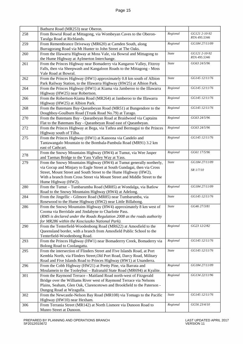
State GG38 12/3/10
161 From the Pacific Highway at the intersection of Bridge Road and Jersey Street North at Hornsby via Bridge Road, old Pacific Highway, Hookhams Corner, and Galston Road to Old Northern Road at Dural.
State GG39 7/2/03
162 From Blaxland Road (MR139) at Ryde, via Lane Cove Road, De Burghs Bridge, Ryde Road and Mona Vale Road to Pittwater Road (MR164) at Mona Vale.
State GG145 12/11/76
163 From Richmond Road (MR184) near Clarendon, to the Richmond Aerodrome near Richmond.
Regional GG145 12/11/76
164 From Pacific Highway (HW10) at Crows Nest via Falcon Street, Merlin Street, Military Road, Spit Road, Spit Bridge, Manly Road, Burnt Bridge Creek Deviation, Condamine Street, Pittwater Road, Barrenjoey Road and Ocean Road to Palm Beach Road at Palm Beach; and With a branch from Merlin Street at Neutral Bay via Falcon Street to Military Road.
State GG38 12/3/10
165 From the southern toll plaza of Sydney Harbour Bridge at Millers Point via Western Distributor, to Anzac Bridge including: On-load ramps from Kent Street and Clarence Street, Off-load ramps to York Street and Grosvenor Street, On-load ramps from Sussex Street at Druitt Street and at Market Street, On-load ramps from Harris Street at Fig Street, On-load ramp from Pyrmont Street, Exit road to Wheat Road/ Shelley Street near the Pedestrian Footbridge opposite King Street, Off-load ramps to King Street at Sussex Street, and to Harbour Street at Bathurst Street, Off-load ramp to Harris Street at Fig Street, Eastbound and Westbound Off-load ramps to Pyrmont Bridge Road, Eastbound and Westbound On-load ramps from Pyrmont Bridge Road, Off-load ramp to Allen Street, the ground level connections of Western Distributor from Bathurst Street to 100 metres north of Old Pyrmont Bridge; then via Anzac Bridge, and Victoria Road to Church Street, Parramatta, including the on-load ramp through the White Bay Underpass from The Crescent at Rozelle.
State GG54 28/2/03
166 From MR165, at the Huntleys Point interchange, via the Tarban Creek bridge, Fig Tree bridge, Burns Bay Road and Centennial Avenue to Epping Road (MR373) at Lane Cove.
State GG145 12/11/76
PREPARED BY PLANNING AND OPERATIONS BRANCH LAST UPDATED APRIL 2017 SF2012/015672 VERSION 11
Page 10
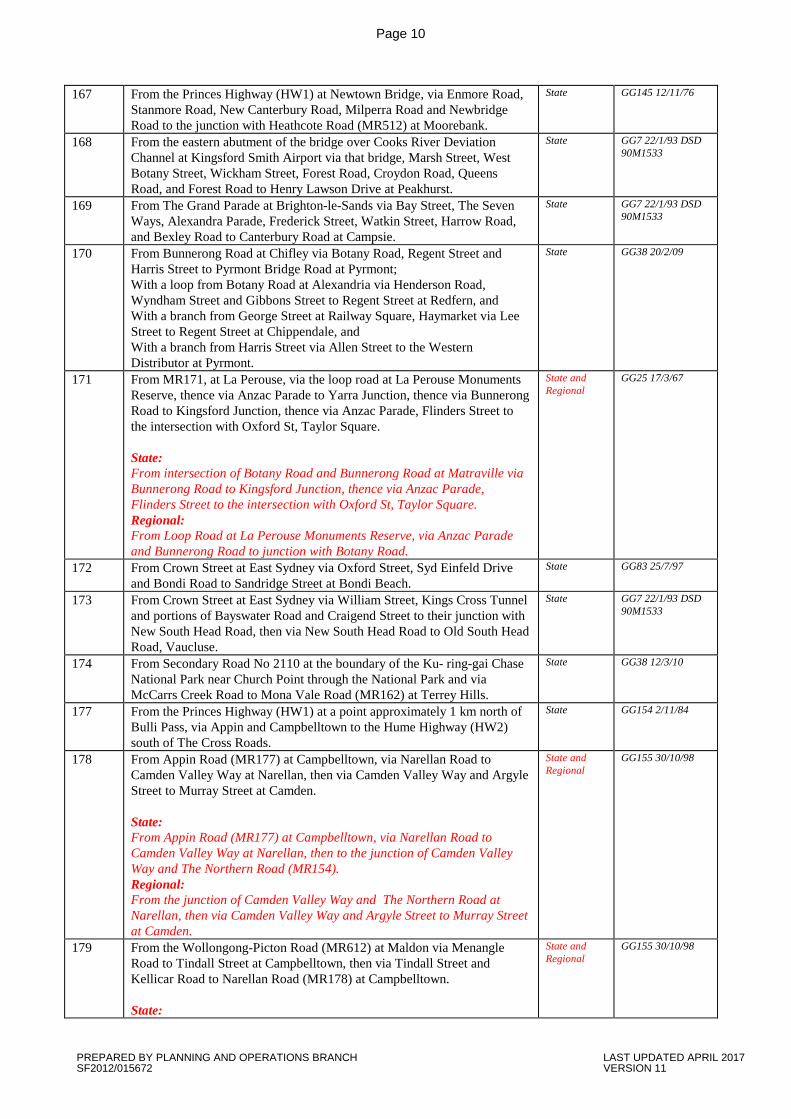
167 From the Princes Highway (HW1) at Newtown Bridge, via Enmore Road, Stanmore Road, New Canterbury Road, Milperra Road and Newbridge Road to the junction with Heathcote Road (MR512) at Moorebank.
State GG145 12/11/76
168 From the eastern abutment of the bridge over Cooks River Deviation Channel at Kingsford Smith Airport via that bridge, Marsh Street, West Botany Street, Wickham Street, Forest Road, Croydon Road, Queens Road, and Forest Road to Henry Lawson Drive at Peakhurst.
State GG7 22/1/93 DSD 90M1533
169 From The Grand Parade at Brighton-le-Sands via Bay Street, The Seven Ways, Alexandra Parade, Frederick Street, Watkin Street, Harrow Road, and Bexley Road to Canterbury Road at Campsie.
State GG7 22/1/93 DSD 90M1533
170 From Bunnerong Road at Chifley via Botany Road, Regent Street and Harris Street to Pyrmont Bridge Road at Pyrmont; With a loop from Botany Road at Alexandria via Henderson Road, Wyndham Street and Gibbons Street to Regent Street at Redfern, and With a branch from George Street at Railway Square, Haymarket via Lee Street to Regent Street at Chippendale, and With a branch from Harris Street via Allen Street to the Western Distributor at Pyrmont.
State GG38 20/2/09
171 From MR171, at La Perouse, via the loop road at La Perouse Monuments Reserve, thence via Anzac Parade to Yarra Junction, thence via Bunnerong Road to Kingsford Junction, thence via Anzac Parade, Flinders Street to the intersection with Oxford St, Taylor Square. State: From intersection of Botany Road and Bunnerong Road at Matraville via Bunnerong Road to Kingsford Junction, thence via Anzac Parade, Flinders Street to the intersection with Oxford St, Taylor Square. Regional: From Loop Road at La Perouse Monuments Reserve, via Anzac Parade and Bunnerong Road to junction with Botany Road.
State and Regional
GG25 17/3/67
172 From Crown Street at East Sydney via Oxford Street, Syd Einfeld Drive and Bondi Road to Sandridge Street at Bondi Beach.
State GG83 25/7/97
173 From Crown Street at East Sydney via William Street, Kings Cross Tunnel and portions of Bayswater Road and Craigend Street to their junction with New South Head Road, then via New South Head Road to Old South Head Road, Vaucluse.
State GG7 22/1/93 DSD 90M1533
174 From Secondary Road No 2110 at the boundary of the Ku- ring-gai Chase National Park near Church Point through the National Park and via McCarrs Creek Road to Mona Vale Road (MR162) at Terrey Hills.
State GG38 12/3/10
177 From the Princes Highway (HW1) at a point approximately 1 km north of Bulli Pass, via Appin and Campbelltown to the Hume Highway (HW2) south of The Cross Roads.
State GG154 2/11/84
178 From Appin Road (MR177) at Campbelltown, via Narellan Road to Camden Valley Way at Narellan, then via Camden Valley Way and Argyle Street to Murray Street at Camden. State: From Appin Road (MR177) at Campbelltown, via Narellan Road to Camden Valley Way at Narellan, then to the junction of Camden Valley Way and The Northern Road (MR154). Regional: From the junction of Camden Valley Way and The Northern Road at Narellan, then via Camden Valley Way and Argyle Street to Murray Street at Camden.
State and Regional
GG155 30/10/98
179 From the Wollongong-Picton Road (MR612) at Maldon via Menangle Road to Tindall Street at Campbelltown, then via Tindall Street and Kellicar Road to Narellan Road (MR178) at Campbelltown. State:
State and Regional
GG155 30/10/98
PREPARED BY PLANNING AND OPERATIONS BRANCH LAST UPDATED APRIL 2017 SF2012/015672 VERSION 11
Page 11
From the northern abutment of the bridge over the Nepean River via Menangle Road, Tindall Street and Kellicar Road to Narellan Road (MR178) at Campbelltown. Regional: From the Wollongong - Picton Road (MR612) at Maldon via Menangle Road to and including the bridge over the Nepean River.
181 Section A: From the Windsor Road at McGraths Hill via Pitt Town, Cattai, Village of Wisemans Ferry, Webbs Creek Ferry over the Hawkesbury River, then along the western side of the Hawkesbury River and MacDonnell River northerly, via St Albans to Wollombi, then via Millfield and Bellbird to Allandale Road at Cessnock. Section B: From Broke to the Golden Highway (Putty Road) approximately 9.6km south of Singleton. State: Section A: From the Windsor Road at McGraths Hill via Bathurst Street, Eldon Street, Pitt Town, then via Cattai Road to Cattai, then via Wisemans Ferry Road, Maroota, and Old Northern Road to the intersection of River Road at Village of Wisemans Ferry. Regional: Section A continued: From Old Northern Road at Village of Wiseman’s Ferry via River Road, the Webbs Creek Ferry over the Hawkesbury River, and St Albans Road to St Albans, then via Bucketty, Yallambie, Laguna, Wollombi, then via Millfield, Pelton, Bellbird to Allendale Road at Cessnock. Section B: From Broke to the Golden Highway (Putty Road) approximately 9.6km south of Singleton.
State and Regional
GG134 22/11/96
182 From the junction of Macquarie Street and Bridge Street (MR184) Windsor, via Bridge Street and the bridge over the Hawkesbury River, Wilberforce and Sackville Reach Ferry to the McGraths Hill-Wisemans Ferry Road (MR181). State: From the junction of Macquarie Street and Bridge Street (MR184) Windsor, via Bridge Street and the bridge over the Hawkesbury River, then via Wilberforce Road to the junction of The Putty Road (MR503) Wilberforce. Regional: From the junction of The Putty Road (MR503) and King Road Wilberforce, via King Road and Sackville Road, Wilberforce, then via Ebenezer to the Sackville Reach Ferry, Sackville, then from the northwestern side of the Hawkesbury River, Sackville via Sackville Road to the McGraths Hill-Wisemans Ferry Road (MR181) at Maroota.
State and Regional
GG145 12/11/76
183 From Avoca Street at Kingsford via Rainbow Street to Anzac Parade at The Nine Ways, Kingsford, then from Bunnerong Road at The Nine Ways, Kingsford via Gardeners Road, Kent Road, Ricketty Street and Canal Road to Princes Highway at St Peters.
State GG7 22/1/93 DSD 90M1533
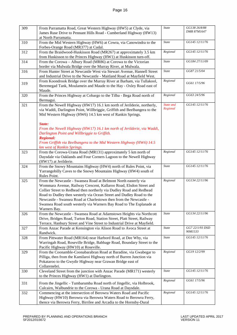
184 From the junction of Victoria Road (MR165) and Church Street, Parramatta, via Church Street, Windsor Road and Bridge Street to Macquarie Street, Windsor then via Macquarie Street, Richmond Road, Windsor Street, East Market Street, March Street and Kurrajong Road at Richmond, the bridge over the Hawkesbury River at North Richmond and Bells Line of Road via North Richmond, Kurrajong, and Bilpin to Bell, then to the Great Western Highway (HW5) at Mount Victoria.
State GG38 12/3/10
185 LAWRENCE HARGRAVE DRIVE - From the Princes Highway at the foot of Bulli Pass via Thirroul, Austimer, Clifton and Bald Hill to the junction with Old Princes Highway and Southern Freeway southbound ramps at Helensburgh Interchange, then south along the former Princes Highway to the junction with the Southern Freeway northbound ramps.
State GG189 25/10/02
PREPARED BY PLANNING AND OPERATIONS BRANCH LAST UPDATED APRIL 2017 SF2012/015672 VERSION 11
Page 12
187 From the Gwydir Highway (HW12) near Inverell, via Graman and Wallangra to the Warialda-Goondiwindi Road (MR63) about 24 km south of Yetman.
Regional GG145 12/11/76
188 From the intersection of Stewart Avenue and Parry Street at Newcastle West easterly via King Street to Darby Street, then southerly and westerly via Darby Street, Glebe Road, St James Road, Royal Road and Royal Place, Lambton Road and Howe Street to Croudace Street at Lambton, then northerly from Griffiths Road at Lambton via Lambton Road, Edith Street and Lorna Street to Maud Street at Waratah West.
Regional GG134 22/11/96
189 From the Tenterfield-Woodenbong Road (MR622) at Legume, via Acacia Creek to the Queensland border.
Regional GG23 12/2/82
190 From Heathcote Road at Lucas Heights via New Illawarra Road, Alfords Point Road, Davies Road, Fairford Road, Fairford Road extension, Stacey Street, Rookwood Road, Joseph Street, Olympic Drive, Boorea Street, Rawson Street, St Hilliers Road, and Silverwater Road and its extension to Kissing Point Road at Dundas; With a branch from Davies Road at the Clancy Street Interchange via Clancy Street to Henry Lawson Drive at Padstow Heights; With a branch from the Fairford Road extension via Stacey Street South to Canterbury Road at Bankstown; and With a branch from the intersection of Rookwood Road and Stacey Street at Yagoona via Rookwood Road to Liverpool Road (HW2 - Hume Highway) at Yagoona.
State GG38 20/2/09
191 From the Pacific Highway (HW10) at Chatswood, via Fullers Road, Millwood Avenue, Fullers Bridge and Delhi Road to Epping Road (MR373) at North Ryde.
State GG145 12/11/76
192 From the Gloucester - Nabiac Road at Krambach via Burrell Creek, Killawarra Bridge and Wingham to Manning River Drive at Taree.
Regional GG134 22/11/96
193 From McEvoy Street at Erskineville via Fountain Street, Mitchell Road, Copeland Street, Swanson Street and Erskineville Road to King Street (Princes Highway) at Newtown; With a branch from Erskineville Road, Newtown, via Wilson Street to King Street (Princes Highway), Newtown.
State GG7 22/1/93 DSD 90M1533
194 From Rocky Point Road at Sans Souci via Sandringham Street, The Grand Parade and General Holmes Drive to Botany Road at Mascot; With a branch from General Holmes Drive via Mill Pond Road to Botany Road adjacent to Kingsford Smith Airport at Botany.
State GG7 22/1/93 DSD 90M1533
195 From the Cessnock - Toronto Road at Mulbring via Richmond Vale to Stanford Street at Pelaw Main, then via Stanford Street and Railway Street to Victoria Street at Kurri Kurri, then from the intersection of Victoria Street and Mitchell Avenue at Kurri Kurri via Lang Street and Main Road, Heddon Greta and Gillieston Heights to the New England Highway at Maitland.
State GG43 24/4/97
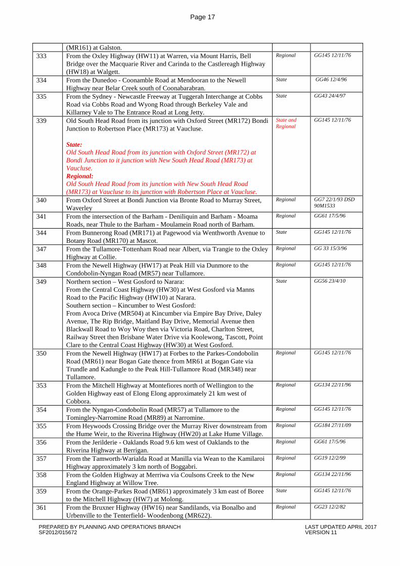
197 From the Howlong Bridge over the Murray River, near Howlong, to the Riverina Highway (HW20) at Howlong.
Regional GG145 12/11/76
198 From the Pacific Highway (HW10) at South Kempsey via South West Rocks Road to Smithtown Road (MR556) at Gladstone.
Regional GG56 23/4/10
199 From Kingsway (MR227), Caringbah via Taren Point Road, Captain Cook Bridge and Rocky Point Road to the Princes Highway (HW1) at Kogarah.
State GG145 12/11/76
200 From Princes Highway at Blakehurst via King Georges Road, Wiley Avenue and Roberts Road to Liverpool Road (Hume Highway), South Strathfield, then from Liverpool Road via Centenary Drive, (including on/off load ramps and loop road, via Marlborough Road at Flemington), Homebush Bay Drive, Concord Road, Church Street and Devlin Street to the southern intersection with Blaxland Road at Ryde.
State GG7 22/1/93 DSD 90M1533
202 From the Oxley Highway (HW11) 5 km north-east of Warren, via Quambone to Warren-Walgett Road (MR333) at Carinda.
Regional GG145 12/11/76
205 From the Newell Highway south east of Tooraweenah to the John Renshaw Parkway at Gumin.
Regional GG 33 15/3/96
208 From the Golden Highway at Sandy Hollow via Wollar to the Lithgow- Regional GG134 22/11/96
PREPARED BY PLANNING AND OPERATIONS BRANCH LAST UPDATED APRIL 2017 SF2012/015672 VERSION 11
Page 13
Gulgong Road at Mudgee. 209 From the New England Highway at Muswellbrook to the Golden Highway
east of Denman. State GG134 22/11/96
211 From the Hume Highway (HW2) southern interchange at Holbrook, along Albury St, Holbrook then via Wagga Rd through Cookardinia and Mangoplah to the Sturt Highway (HW14) at Wagga Wagga.
Regional GG145 12/11/76
214 From the Muswellbrook-Mudgee Road approximately 9 km north of Mudgee via Ulan to the Golden Highway approximately 8 km south-west of Cassilis.
Regional GG134 22/11/96
215 From the Lithgow-Mudgee (MR55) at Ilford, via Rylstone and Bylong to the Muswellbrook-Mudgee Road (MR208) near Bylong.
Regional GG145 12/11/76
216 From the Bathurst-Ilford Road (MR54) at Sofala, via Hill End and Hargraves to the Mudgee-Gulgong road near Mudgee.
Regional GG145 12/11/76
217 From the Sydney-Newcastle Freeway at Morisset Interchange at Mandalong Road via Morisset, Toronto and Cockle Creek to Glendale, then via Lake Road to Thomas Street at Wallsend. With a branch from Lake Road at Glendale via Glendale Drive to Main Road at Glendale.
State GG134 22/11/96
220 From Carey Street at Toronto via Awaba and Ryhope, Freemans Waterholes, Heaton Gap, Brunkerville and Mount Vincent to Lake Road near Mulbring, then via Kearsley and Aberdare to Vincent Street at Cessnock, then via Vincent Street, Wollombi Road and Allandale Road to Nulkaba, then via Rothbury to the New England Highway at Branxton. With a branch from Freemans Waterholes via Inglewood Road to the Sydney - Newcastle Freeway at Freemans Interchange.
State GG43 24/4/97
222 From the Swan Hill-Ivanhoe Road (MR67) at Kyalite to the Murray River at Tooleybuc.
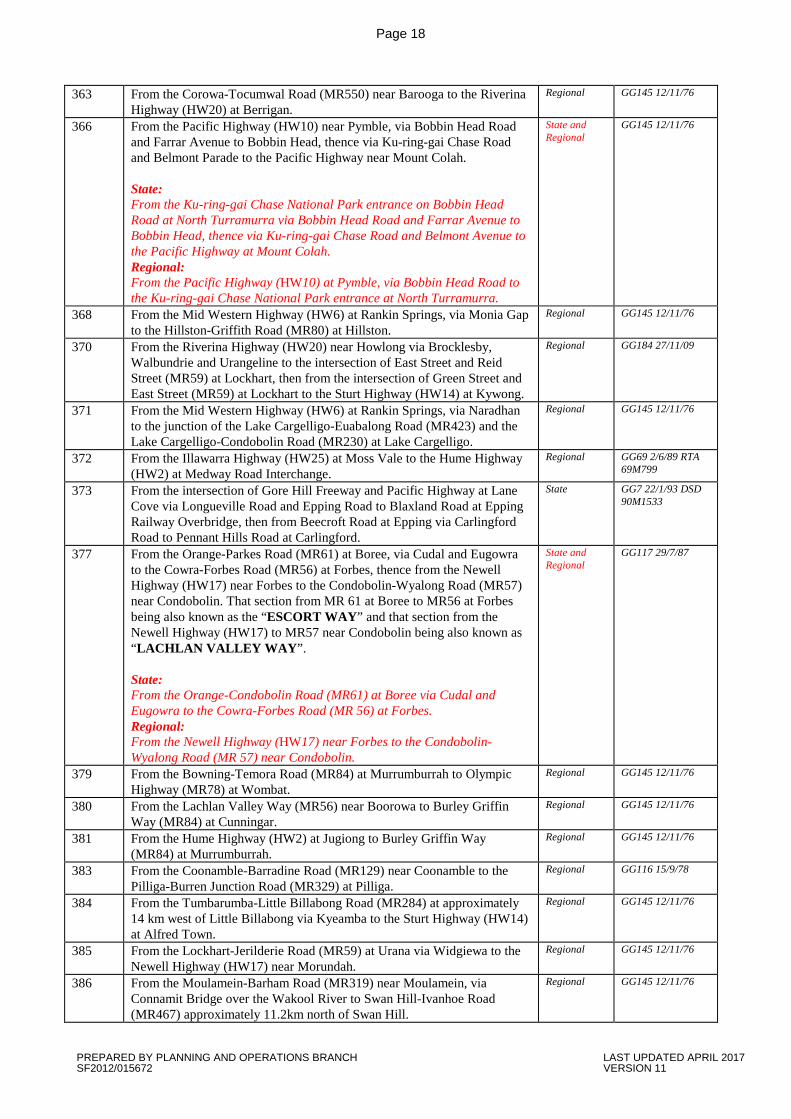
Regional GG145 12/11/76 (note: to be revoked – is now declared as part of MR694 (State Road))
223 From Brunker Road at Broadmeadow via Lambton Road, Alma Road, Rugby Road and Russell Road to the intersection of Lookout Road and Croudace Road at New Lambton, then from the intersection of Charlestown Road and Lookout Road at New Lambton Heights via Main Road to Macquarie Road at Cardiff.
Regional GG134 2/11/96
225 From the Calga - Somersby Road east of Central Mangrove via Central Mangrove, Mangrove Mountain, Spencer, Gunderman and Wisemans Ferry over Hawkesbury River to the McGraths Hill-Whittingham Road at the village of Wisemans Ferry. Regional: From the Calga - Somersby Road east of Central Mangrove via Central Mangrove, Mangrove Mountain, Spencer and Gunderman to the northern bank of the Hawkesbury River at Wisemans Ferry. State: From the northern bank of the Hawkesbury River at Wisemans Ferry to the McGraths Hill-Whittingham Road (MR181) (Intersection of River Road and Old Northern Road) at the village of Wisemans Ferry.
State and Regional
GG134 22/11/96
226 From the Corowa-Tocumwal Road (MR550) at Barooga to the Cobram Bridge over the Murray River.
Regional GG145 12/11/76
227 From Elouera Road at Cronulla via Kingsway to Princes Highway at Kirrawee.
State GG7 22/1/93 DSD 90M1533
228 From the Condobolin-Cobar Road (MR61) at Nymagee to the Barrier Highway (HW8) at Hermidale.
Regional GG145 12/11/76
231 From the West Wyalong-Condobolin Road (MR57) at Girral via Ungarie to the Rankin Springs-Lake Cargelligo Road (MR371) at Lake Cargelligo.
Regional GG145 12/11/76
232 From the Carnarvon Highway at Garah, via Boomi to the Queensland Border at Boonangar.
Regional GG117 7/8/98
233 From Percy Street (Mitchell Highway HW7) at Wellington via Renshaw – Regional GG38 12/3/10
PREPARED BY PLANNING AND OPERATIONS BRANCH LAST UPDATED APRIL 2017 SF2012/015672 VERSION 11
Page 14
McGirr Way through Walmar, Yeoval and Baldry to Clarinda Street East (Henry Parkes Way MR61) at Parkes.
234 From the Mitchell Highway at Molong, via Norah Creek and Cumnock to the Parkes-Wellington Road at Yeoval.
Regional GG 33 15/3/96
235 From Hovell Street (Olympic Highway MR78) at Cootamundra to Burley Griffin Way MR84) at Stockinbingal.
Regional GG184 27/11/09
236 HENRY LAWSON WAY-From the Mid Western Highway (HW6) at Bogo Bogalong, west of Grenfell to the Gooloogong-Forbes Road (MR56) at Forbes.
Regional GG145 12/11/76
237 From the Mid Western Highway at Grenfell, via Gooloogong and Nyrang Creek to Canowindra, then from the Canowindra-Cudal Road north of Canowindra via Cargo to the Mitchell Highway at Orange.
Regional GG 33 15/3/96
238 From the Canowindra-Gooloogong Road at Nyrang Creek, to the Cudal-Forbes Road at Eugowra, then from the Cudal-Forbes Road west of Eugowra to the Orange-Parkes Road at Parkes.
Regional GG 33 15/3/96
239 HENRY LAWSON WAY - From Elizabeth Street (Olympic Highway MR78) at Young via Iandra Street, and Tyagong to Camp Street (Mid Western Highway HW6) at Grenfell.
Regional GG184 27/11/09
240 From the Olympic Highway (MR78) near Wagga Wagga, via Coolamon to the Newell Highway (HW17) near Ardlethan.
Regional GG145 12/11/76
241 From Yass Street (Gunning – Crookwell Road MR52) at Gunning via Dalton and Rye Park to the Lachlan Valley Way (MR56) at Boorowa, then from the Lachlan Valley Way (MR56) at Boorowa to the Olympic Highway (MR78) at Young, then from the Olympic Highway (MR78) at Young via Grogan to Waratah Street at Temora, then via Waratah Street to the Burley Griffin Way (MR84) at Temora.
Regional GG184 27/11/09
243 From the Hume Highway (HW2) at Gundagai via Nangus, Eurongilly, Junee, Coolamon and Ganmain to the Newell Highway (HW17) at Grong Grong.
Regional GG145 12/11/76
244 From the Mid Western Highway near Gunbar South to Tabbita Lane. Regional
GG61 17/5/96
245 From the Mid Western Highway (HW6) at Blayney via Millthorpe and Spring Hill to the Mitchell Highway (HW7) at Orange. State: From the Mid Western Highway (HW6) at Blayney to the junction with the Whileys Junction-Shadforth Road (MR559) east of Spring Hill. Regional: From the junction with Whileys Junction-Shadforth Road (MR559) east of Spring Hill to the Mitchell Highway (HW7) at Orange.
State and Regional
GG145 12/11/76
248 From the Goulburn-Oberon Road (MR256) at Taralga via Laggan to Trunk Road No.54 at Crookwell, thence from MR54 near Crookwell via Narrawa to the Boorowa-Gunning Road (MR241) at Boorowa.
Regional GG145 12/11/76
253 From the Great Western Highway (HW5) at Hartley, via Hampton, Jenolan Caves and Oberon to the Great Western Highway (HW5) near Bathurst. State: First Section: From the Great Western Highway (HW5) at Hartley via Hampton and Jenolan Caves to the junction with Kanangra Walls Road. Regional: From Kanangra Walls Road via Edith to Oberon. State: Second Section: From Oberon via Wisemans Creek to the Great Western Highway (HW5) near Bathurst.
State and Regional
GG145 12/11/76
254 From the Leeton - Griffith Road near Wumbulgal to the Bowning - Griffith Road (Burley Griffin Way) at Yenda.
Regional GG91 2/8/96
255 From Albion Road at Oberon, via Tarana to the Great Western Highway at Diamond Swamp.
Regional GG 33 15/3/96
256 From Lagoon Street (MR676) at Goulburn via Taralga to the Oberon – Regional GG38 12/3/10
PREPARED BY PLANNING AND OPERATIONS BRANCH LAST UPDATED APRIL 2017 SF2012/015672 VERSION 11
Page 15
Bathurst Road (MR253) near Oberon. 258 From Bowral Road at Mittagong, via Wombeyan Caves to the Oberon-
Taralga Road at Richlands. Regional GG121 2-10-92
RTA 495.5346
259 From Remembrance Driveway (MR620) at Camden South, along Burragorang Road via Mt Hunter to John Street at The Oaks.
Regional GG184 27/11/09
260 From the Illawarra Highway at Moss Vale, via Bowral and Mittagong to the Hume Highway at Aylmerton Interchange.
State GG121 2-10-92 RTA 495.5346
261 From the Princes Highway near Bomaderry via Kangaroo Valley, Fitzroy Falls, then via Sheepwash and Kangaloon Roads to the Mittagong - Moss Vale Road at Bowral.
State GG63 24/5/96
262 From the Princes Highway (HW1) approximately 0.8 km south of Albion Park Railway Station, to the Illawarra Highway (HW25) at Albion Park.
State GG145 12/11/76
264 From the Princes Highway (HW1) at Kiama via Jamberoo to the Illawarra Highway (HW25) near Robertson.
Regional GG145 12/11/76
266 From the Robertson-Kiama Road (MR264) at Jamberoo to the Illawarra Highway (HW25) at Albion Park.
Regional GG145 12/11/76
268 From the Batemans Bay-Queanbeyan Road (MR51) at Bungendore to the Doughboy-Goulburn Road (Trunk Road No.79) at Tarago.
Regional GG145 12/11/76
270 From the Batemans Bay - Queanbeyan Road at Braidwood via Captains Flat to the Batemans Bay - Queanbeyan Road east of Queanbeyan.
Regional GG63 24/5/96
272 From the Princes Highway at Bega, via Tathra and Bermagui to the Princes Highway south of Tilba.
Regional GG63 24/5/96
275 From the Princes Highway (HW1) at Kanoona via Candelo and Tantawangalo Mountain to the Bombala-Pambula Road (MR91) 3.2 km east of Cathcart.
Regional GG145 12/11/76
278 From the Snowy Mountains Highway (HW4) at Tumut, via Wee Jasper and Taemas Bridge to the Yass Valley Way at Yass.
Regional GG61 17/5/96
279 From the Snowy Mountains Highway (HW4) at Tumut generally northerly, via Gocup and Minjary to Eagle Street at South Gundagai, then via Cross Street, Mount Street and South Street to the Hume Highway (HW2), With a branch from Cross Street via Mount Street and Middle Street to the Hume Highway (HW2).
State GG184 27/11/09 SR 1/7/10
280 From the Tumut – Tumbarumba Road (MR85) at Wondalga, via Batlow Road to the Snowy Mountains Highway (HW4) at Adelong.
Regional GG184 27/11/09
284 From the Jingellic - Gilmore Road (MR85) near Tumbarumba, via Rosewood to the Hume Highway (HW2) near Little Billabong.
State GG145 12/11/76
286 From the Snowy Mountains Highway (HW4) approximately 8 km west of Cooma via Berridale and Jindabyne to Charlotte Pass. (RMS is declared under the Roads Regulation 2008 as the roads authority for MR286 within the Kosciuszko National Park).
State GG46 27/3/81
290 From the Tenterfield-Woodenbong Road (MR622) at Amosfield to the Queensland border, with a branch from Amosfield Public School to the Tenterfield-Woodenbong Road.
Regional GG23 12/2/82
293 From the Princes Highway (HW1) near Bomaderrry Creek, Bomaderry via Bolong Road to Coolangatta.
Regional GG145 12/11/76
295 From the intersection of Flinders Street and Five Islands Road, at Port Kembla North, via Flinders Street,Old Port Road, Darcy Road, Military Road and Five Islands Road to Princes Highway (HW1) at Unanderra.
State GG145 12/11/76
296 From the Cobb Highway (HW21) at Pretty Pine, via Barrata and Moulamein to the Tooleybuc – Balranald State Road (MR694) at Kyalite.
Regional GG184 27/11/09
301 From the Raymond Terrace - Maitland Road north-west of Fitzgerald Bridge over the Williams River west of Raymond Terrace via Nelsons Plains, Seaham, Glen Oak, Clarencetown and Brookfield to the Paterson - Dungog Road at Wiragulla.
Regional GG134 22/11/96
302 From the Newcastle-Nelson Bay Road (MR108) via Tomago to the Pacific Highway (HW10) near Hexham.
State GG145 12/11/76
306 From Terrania Street (MR142) at North Lismore via Dunoon Road to Munro Street at Dunoon.
Regional GG56 23/4/10
PREPARED BY PLANNING AND OPERATIONS BRANCH LAST UPDATED APRIL 2017 SF2012/015672 VERSION 11
Page 16
309 From Parramatta Road, Great Western Highway (HW5) at Clyde, via James Ruse Drive to Pennant Hills Road - Cumberland Highway (HW13) at North Parramatta.
State GG138 26/8/88 DMR 87M1647
310 From the Mid Western Highway (HW6) at Cowra, via Canowindra to the Forbes-Orange Road (MR377) at Cudal.
State GG145 12/11/76
312 From the Braidwood-Huskisson Road (MR267) at approximately 3.5 km from Huskisson to the Princes Highway (HW1) at Huskisson turn-off.
Regional GG145 12/11/76
314 From the Corowa – Albury Road (MR86) at Corowa to the Victorian border via Mulwala Bridge over the Murray River, at Mulwala.
State GG184 27/11/09
316 From Hunter Street at Newcastle West via Stewart Avenue, Hannell Street and Industrial Drive to the Newcastle - Maitland Road at Mayfield West.
State GG87 21/5/04
319 From Koondrook Bridge over the Murray River at Barham, via Tullakool, Beremegad Tank, Moulamein and Maude to the Hay - Oxley Road east of Maude.
Regional GG61 17/5/96
320 From the Princes Highway at Cobargo to the Tilba - Bega Road north of Bermagui.
Regional GG63 24/5/96
321 From the Newell Highway (HW17) 16.1 km north of Jerilderie, northerly, via Waddi, Darlington Point, Willbriggie, Griffith and Beelbangera to the Mid Western Highway (HW6) 14.5 km west of Rankin Springs. State: From the Newell Highway (HW17) 16.1 km north of Jerilderie, via Waddi, Darlington Point and Willbriggie to Griffith. Regional: From Griffith via Beelbangera to the Mid Western Highway (HW6) 14.5 km west of Rankin Springs.
State and Regional
GG145 12/11/76
323 From the Corowa-Urana Road (MR131) approximately 5 km north of Daysdale via Oaklands and Four Corners Lagoon to the Newell Highway (HW17) at Jerilderie.
Regional GG145 12/11/76
324 From the Snowy Mountains Highway (HW4) north of Rules Point, via Yarrangobilly Caves to the Snowy Mountains Highway (HW4) south of Rules Point.
State GG145 12/11/76
325 From the Newcastle - Swansea Road at Belmont North easterly via Wommara Avenue, Railway Crescent, Kallaroo Road, Elsdon Street and Collier Street to Redhead then northerly via Dudley Road and Redhead Road to Dudley then westerly via Ocean Street and Dudley Road to the Newcastle - Swansea Road at Charlestown then from the Newcastle - Swansea Road south westerly via Warners Bay Road to The Esplanade at Warners Bay.
Regional GG134 22/11/96
326 From the Newcastle - Swansea Road at Adamstown Heights via Northcott Drive, Bridges Road, Turton Road, Station Street, Platt Street, Railway Terrace, Hanbury Street and Vine Street to Industrial Drive at Mayfield.
State GG134 22/11/96
327 From Anzac Parade at Kensington via Alison Road to Avoca Street at Randwick.
State GG7 22/1/93 DSD 90M1533
328 From Pittwater Road (MR164) near Harbord Road, at Dee Why, via Warringah Road, Roseville Bridge, Babbage Road, Boundary Street to the Pacific Highway (HW10) at Roseville.
State GG145 12/11/76
329 From the Coonamble-Coonabarabran Road at Baradine, via Gwabegar to Pilliga, then from the Kamilaroi Highway north of Burren Junction via Pokataroo to the Gwydir Highway near Grawan Bridge east of Collarenebri.
Regional GG19 12/2/99
330 Cleveland Street from the junction with Anzac Parade (MR171) westerly to the Princes Highway (HW1) at Darlington.
State GG145 12/11/76
331 From the Jingellic - Tumbarumba Road north of Jingellic, via Holbrook, Culcairn, Walbundrie to the Corowa - Urana Road at Daysdale.
Regional GG61 17/5/96
332 Commencing at the intersection of Berowra Waters Road and Pacific Highway (HW10) Berowra via Berowra Waters Road to Berowra Ferry, thence via Berowra Ferry, Birrilee and Arcadia to the Hornsby-Dural
Regional GG145 12/11/76
PREPARED BY PLANNING AND OPERATIONS BRANCH LAST UPDATED APRIL 2017 SF2012/015672 VERSION 11
Page 17
(MR161) at Galston. 333 From the Oxley Highway (HW11) at Warren, via Mount Harris, Bell
Bridge over the Macquarie River and Carinda to the Castlereagh Highway (HW18) at Walgett.
Regional GG145 12/11/76
334 From the Dunedoo - Coonamble Road at Mendooran to the Newell Highway near Belar Creek south of Coonabarabran.
State GG46 12/4/96
335 From the Sydney - Newcastle Freeway at Tuggerah Interchange at Cobbs Road via Cobbs Road and Wyong Road through Berkeley Vale and Killarney Vale to The Entrance Road at Long Jetty.
State GG43 24/4/97
339 Old South Head Road from its junction with Oxford Street (MR172) Bondi Junction to Robertson Place (MR173) at Vaucluse. State: Old South Head Road from its junction with Oxford Street (MR172) at Bondi Junction to it junction with New South Head Road (MR173) at Vaucluse. Regional: Old South Head Road from its junction with New South Head Road (MR173) at Vaucluse to its junction with Robertson Place at Vaucluse.
State and Regional
GG145 12/11/76
340 From Oxford Street at Bondi Junction via Bronte Road to Murray Street, Waverley
Regional GG7 22/1/93 DSD 90M1533
341 From the intersection of the Barham - Deniliquin and Barham - Moama Roads, near Thule to the Barham - Moulamein Road north of Barham.
Regional GG61 17/5/96
344 From Bunnerong Road (MR171) at Pagewood via Wenthworth Avenue to Botany Road (MR170) at Mascot.
State GG145 12/11/76
347 From the Tullamore-Tottenham Road near Albert, via Trangie to the Oxley Highway at Collie.
Regional GG 33 15/3/96
348 From the Newell Highway (HW17) at Peak Hill via Dunmore to the Condobolin-Nyngan Road (MR57) near Tullamore.
Regional GG145 12/11/76
349 Northern section – West Gosford to Narara: From the Central Coast Highway (HW30) at West Gosford via Manns Road to the Pacific Highway (HW10) at Narara. Southern section – Kincumber to West Gosford: From Avoca Drive (MR504) at Kincumber via Empire Bay Drive, Daley Avenue, The Rip Bridge, Maitland Bay Drive, Memorial Avenue then Blackwall Road to Woy Woy then via Victoria Road, Charlton Street, Railway Street then Brisbane Water Drive via Koolewong, Tascott, Point Clare to the Central Coast Highway (HW30) at West Gosford.
State GG56 23/4/10
350 From the Newell Highway (HW17) at Forbes to the Parkes-Condobolin Road (MR61) near Bogan Gate thence from MR61 at Bogan Gate via Trundle and Kadungle to the Peak Hill-Tullamore Road (MR348) near Tullamore.
Regional GG145 12/11/76
353 From the Mitchell Highway at Montefiores north of Wellington to the Golden Highway east of Elong Elong approximately 21 km west of Cobbora.
Regional GG134 22/11/96
354 From the Nyngan-Condobolin Road (MR57) at Tullamore to the Tomingley-Narromine Road (MR89) at Narromine.
Regional GG145 12/11/76
355 From Heywoods Crossing Bridge over the Murray River downstream from the Hume Weir, to the Riverina Highway (HW20) at Lake Hume Village.
Regional GG184 27/11/09
356 From the Jerilderie - Oaklands Road 9.6 km west of Oaklands to the Riverina Highway at Berrigan.
Regional GG61 17/5/96
357 From the Tamworth-Warialda Road at Manilla via Wean to the Kamilaroi Highway approximately 3 km north of Boggabri.
Regional GG19 12/2/99
358 From the Golden Highway at Merriwa via Coulsons Creek to the New England Highway at Willow Tree.
Regional GG134 22/11/96
359 From the Orange-Parkes Road (MR61) approximately 3 km east of Boree to the Mitchell Highway (HW7) at Molong.
State GG145 12/11/76
361 From the Bruxner Highway (HW16) near Sandilands, via Bonalbo and Urbenville to the Tenterfield- Woodenbong (MR622).
Regional GG23 12/2/82
PREPARED BY PLANNING AND OPERATIONS BRANCH LAST UPDATED APRIL 2017 SF2012/015672 VERSION 11
Page 18
363 From the Corowa-Tocumwal Road (MR550) near Barooga to the Riverina Highway (HW20) at Berrigan.
Regional GG145 12/11/76
366 From the Pacific Highway (HW10) near Pymble, via Bobbin Head Road and Farrar Avenue to Bobbin Head, thence via Ku-ring-gai Chase Road and Belmont Parade to the Pacific Highway near Mount Colah. State: From the Ku-ring-gai Chase National Park entrance on Bobbin Head Road at North Turramurra via Bobbin Head Road and Farrar Avenue to Bobbin Head, thence via Ku-ring-gai Chase Road and Belmont Avenue to the Pacific Highway at Mount Colah. Regional: From the Pacific Highway (HW10) at Pymble, via Bobbin Head Road to the Ku-ring-gai Chase National Park entrance at North Turramurra.
State and Regional
GG145 12/11/76
368 From the Mid Western Highway (HW6) at Rankin Springs, via Monia Gap to the Hillston-Griffith Road (MR80) at Hillston.
Regional GG145 12/11/76
370 From the Riverina Highway (HW20) near Howlong via Brocklesby, Walbundrie and Urangeline to the intersection of East Street and Reid Street (MR59) at Lockhart, then from the intersection of Green Street and East Street (MR59) at Lockhart to the Sturt Highway (HW14) at Kywong.
Regional GG184 27/11/09
371 From the Mid Western Highway (HW6) at Rankin Springs, via Naradhan to the junction of the Lake Cargelligo-Euabalong Road (MR423) and the Lake Cargelligo-Condobolin Road (MR230) at Lake Cargelligo.
Regional GG145 12/11/76
372 From the Illawarra Highway (HW25) at Moss Vale to the Hume Highway (HW2) at Medway Road Interchange.
Regional GG69 2/6/89 RTA 69M799
373 From the intersection of Gore Hill Freeway and Pacific Highway at Lane Cove via Longueville Road and Epping Road to Blaxland Road at Epping Railway Overbridge, then from Beecroft Road at Epping via Carlingford Road to Pennant Hills Road at Carlingford.
State GG7 22/1/93 DSD 90M1533
377 From the Orange-Parkes Road (MR61) at Boree, via Cudal and Eugowra to the Cowra-Forbes Road (MR56) at Forbes, thence from the Newell Highway (HW17) near Forbes to the Condobolin-Wyalong Road (MR57) near Condobolin. That section from MR 61 at Boree to MR56 at Forbes being also known as the “ESCORT WAY” and that section from the Newell Highway (HW17) to MR57 near Condobolin being also known as “LACHLAN VALLEY WAY”. State: From the Orange-Condobolin Road (MR61) at Boree via Cudal and Eugowra to the Cowra-Forbes Road (MR 56) at Forbes. Regional: From the Newell Highway (HW17) near Forbes to the Condobolin-Wyalong Road (MR 57) near Condobolin.
State and Regional
GG117 29/7/87
379 From the Bowning-Temora Road (MR84) at Murrumburrah to Olympic Highway (MR78) at Wombat.
Regional GG145 12/11/76
380 From the Lachlan Valley Way (MR56) near Boorowa to Burley Griffin Way (MR84) at Cunningar.
Regional GG145 12/11/76
381 From the Hume Highway (HW2) at Jugiong to Burley Griffin Way (MR84) at Murrumburrah.
Regional GG145 12/11/76
383 From the Coonamble-Barradine Road (MR129) near Coonamble to the Pilliga-Burren Junction Road (MR329) at Pilliga.
Regional GG116 15/9/78
384 From the Tumbarumba-Little Billabong Road (MR284) at approximately 14 km west of Little Billabong via Kyeamba to the Sturt Highway (HW14) at Alfred Town.
Regional GG145 12/11/76
385 From the Lockhart-Jerilderie Road (MR59) at Urana via Widgiewa to the Newell Highway (HW17) near Morundah.
Regional GG145 12/11/76
386 From the Moulamein-Barham Road (MR319) near Moulamein, via Connamit Bridge over the Wakool River to Swan Hill-Ivanhoe Road (MR467) approximately 11.2km north of Swan Hill.
Regional GG145 12/11/76
PREPARED BY PLANNING AND OPERATIONS BRANCH LAST UPDATED APRIL 2017 SF2012/015672 VERSION 11
Page 19
390 From the Goulburn-Bathurst Road at Trunkey Creek, via Hobbys Yards and Barry to the Mid Western Highway at Blayney.
Regional GG 33 15/3/96
391 From the bridge over the Murray River at Barmah, to the Cobb Highway (HW21) approximately 15.2 km north of Moama.
Regional GG145 12/11/76
393 From Lawence Hargrave Drive (MR185) at the top of Bald Hill northerly along the eastern side of the Port Hacking River to the Upper Causeway thence via Garie Road and Stephens Drive to Artillery Hill thence via Audley Road and Farnell Avenue to the Princes Highway (HW1) near Loftus with a branch from the Upper Causeway via McKell Avenue, Kooraban, Warabin and Yanagang Streets to the Princes Highway (HW1) at Waterfall.
State GG145 12/11/76
394 From the Monaro Highway (HW19) at a point approximately 8 km north of Bibbenluke via Jincumbilly Railway Siding, Maffra and Dalgetty to the Cooma-Mount Kosciusko Road (MR286) near Berridale.
Regional GG145 12/11/76
395 From Parramatta Road (Great Western Highway) at Five Dock via Great North Road and Lyons Road to Victoria Road at Drummoyne; With a branch from Lyons Road at Drummoyne via Bayswater Street and Westbourne Street to Victoria Road; and With a branch from Westbourne Street via Marlborough Road to Lyons Road at Drummoyne.
State GG7 22/1/93 DSD 90M1533
396 From the Mullaley-Mudgee Road north of Coolah, via Weetaliba, Ulinda, Binnaway and Deringulla to the Newell Highway south of Coonabarabran.
Regional GG5 15/1/93 90M1533
397 From the junction of Manly Road and Sydney Road (MR164) Balgowlah, via Sydney Road, Frenchs Forest Road and Wakehurst Parkway to Pittwater Road (MR164) Narrabeen.
State GG145 12/11/76
398 From the Coolamon-Ardlethan Road (MR240) near Dullah via Ariah Park, Broken Dam, Barmedman, Morangorell and Bimbi to the Mid Western Highway (HW6) at Grenfell.
Regional GG145 12/11/76
399 From Murwillumbah-Queensland Border Road (MR143) at Kynnumboon Bridge over the North Arm of the Tweed River, and thence along the upper North Arm of the Tweed River, via Zara and Numinbah to the Queensland border at Numinbah Gap.
Regional GG145 12/11/76
402 From the Kamilaroi Highway approximately 8 km west of Walgett, north westerly to Cumborah, then north easterly to the Castlereagh Highway approximately 7 km south of the road to Lightning Ridge.
Regional GG19 12/2/99
404 From the Mitchell Highway (HW7) at North Bourke generally northwesterly, via Fords Bridge and Yantabulla to the Queensland border at Hungerford.
Regional GG145 12/11/76
405 From the Bourke - Hungerford Road at North Bourke generally via Wanaaring to the Silver City Highway at Tibooburra.
Regional GG7 22/1/93 DSD 90M1533
407 From the Cobar-Bourke Road at Cobar to the Wilcannia-Bourke Road at Louth.
Regional GG 33 15/3/96
410 KIDMAN WAY - From High Street (MR80) at Hillston along the southern side of the Lachlan River via Waalalong to and across Willanthry Bridge over the Lachlan River, then via Matakana, Mount Hope and Gilgunnia to Nyngan Road (Barrier Highway HW8) at Cobar.
State GG38 12/3/10
411 From the Lake Cargelligo-Euabalong Road at Euabalong, via Euabalong West to the Hillston-Cobar Road at Mount Hope.
Regional GG 33 15/3/96
416 From the Barrier Highway (HW8) near Cobar generally south-westerly to the Belarabon-Barnato Tank Road (MR415) at Belarabon.
Regional GG145 12/11/76
419 From the Hillston-Cobar Road at Gilgunnia to the Nymagee-Cobar Road at Nymagee.
Regional GG 33 15/3/96
421 From the Barrier Highway at Cobar, via Helmans Tank and Curraweena Tank to the Mitchell Highway at Bourke.
State GG 33 15/3/96
423 From the junction of the Lake Cargelligo-Condobolin Road (MR230) and the Rankin Springs-Lake Cargelligo Road (MR371) at Lake Cargelligo, generally northerly, via Murrin Bridge over the Lachlan River to the Euabalong-Mount Hope Road (MR411) at Euabalong.
Regional GG145 12/11/76
424 From Coolabah-Brewarrina Road at Stoney Hills, via Monkey Bridge over the Bogan River and bridge over Marra Creek at Mundadoo to the Warren-
Regional GG 33 15/3/96
PREPARED BY PLANNING AND OPERATIONS BRANCH LAST UPDATED APRIL 2017 SF2012/015672 VERSION 11
Page 20
Carinda Road at Wallamgambone. 426 From Collarenebri via Lightning Ridge to the Castlereagh Highway south
west of Lightning Ridge. Regional GG 33 15/3/96
428 From the Broken Hill-Tibooburra Road north of Broken Hill to White Cliffs.
Regional GG 33 15/3/96
431 From the Silver City Highway west of Buronga to Mungo National Park. Regional GG7 22/1/93 DSD 90M1533
433 From the Cobb Highway (HW21) near Ivanhoe via Darnick, Gum Lake siding and Amphi Sandhills to the Wenthworth-Menindee Road (MR68) near Menindee.
Regional GG145 12/11/76
435 From the Barrier Highway at Wilcannia to White Cliffs Regional GG7 22/1/93 DSD 90M1533
437 From the Castlereagh Highway north of Weetaliba Waterholes to the Brewarrina-Hebel Road at Goodooga.
Regional GG 33 15/3/96
450 From the Pacific Highway at Cudgera Creek Road Interchange via Pottsville, Hastings Point, and Bogangar, to the Pacific Highway at Chinderah.
Regional GG246 9/12/02 RNIM 98M8208
453 From the New England Highway at Branxton via Elderslie to the Gresford - Singleton Road near Glendonbrook.
Regional GG134 22/11/96
454 From the Doyalson - Newcastle Road at Doyalson via Wyee Road to the intersection of Mandalong Road and Dora Street at Morisset.
Regional GG134 22/11/96
455 From the Sydney - Newcastle Freeway at Calga Interchange via Peats Ridge to the Sydney - Newcastle Freeway at Somersby Interchange.
Regional GG134 22/11/96
456 From the intersection of Maitland Bay Drive and Memorial Avenue at Woy Woy via Barrenjoey Road, West Street, Sydney Avenue, Hobart Street, Mt Ettalong Road and Patonga Drive to Pearl Beach Drive at Pearl Beach.
Regional GG134 22/11/96
457 From the Gwydir Highway at Collarenebri via Mogil Mogil to the Queensland border near Mungindi.
Regional GG19 12/2/99
460 From the Pacific Highway (HW10) at Clybucca via Plummers Lane, Jerseyville, and South West Rocks Road to Livingstone Street at South West Rocks.
Regional GG56 23/4/10
461 From the intersection of William Street and Lachlan Street (MR57) at Condobolin, via Melrose, Bobadah and Nymagee to the junction with Kidman Way (MR410) near Priory Tank.
Regional GG38 12/3/10
462 From the New England Highway (HW9), approximately 5 km north of Tenterfield, via Bonshaw and Yetman to North Street (Newell Highway HW17) at Boggabilla.
Regional GG56 23/4/10
463 From Gulgan Road (MR689) at Andersons Ridge east of Mullumbimby via Mullumbimby Road, Argyle Street and Burringbar Street to Dalley Street at Mullumbimby.
Regional GG56 23/4/10
464 From the intersection of Stewart Avenue (Pacific Highway HW10) and Hunter Street at Wickham via Hunter Street and Maitland Road to the intersection of Industrial Drive (MR316) and Maitland Road at Warrabrook.
Regional GG56 23/4/10
467 From the bridge over the Murray River at Swan Hill, generally northerly to the Tooleybuc – Balranald State Road (MR694) near Kyalite.
Regional GG184 27/11/09
468 From Argyle Street (MR620) at Picton, via Barkers Lodge Road to Montpellier Drive near Mowbray Park.
Regional GG184 27/11/09
469 From Cudgery Street (Waterfall Way MR76) at Dorrigo via the Megan – Dorrigo Road to the Cascade - Briggsvale Road at Megan.
Regional GG56 23/4/10
501 LACHLAN VALLEY WAY - Section one: From the Lake Cargelligo - Rankins Springs Road (MR371) near Lake Cargelligo generally south-westerlyto the junction with Kidman Way (MR410) near Willanthry; Section two: From McGee Street (MR80) at Hillston along the southern side of the Lachlan River to the Cobb Highway (HW21) at Booligal, and With a branch road to Whealbah Bridge over the Lachlan River.
Regional GG38 12/3/10
503 PUTTY ROAD - From the Windsor - Sackville Road at Wilberforce via Morans Rock, Parrs Brush, Howes Valley, Milbrodale and Bulga to the
State GG134 22/11/96
PREPARED BY PLANNING AND OPERATIONS BRANCH LAST UPDATED APRIL 2017 SF2012/015672 VERSION 11

Page 21
Golden Highway at Mt Thorley. 504 From The Entrance Road (Central Coast Highway HW30) at Erina via
Avoca Drive to Picketts Valley, then via Scenic Highway and Charles Kay Drive to Terrigal Drive (MR505) at Terrigal.
State GG56 23/4/10
505 From The Entrance Road at Erina via Terrigal Drive to Ocean View Drive at Terrigal.
State GG134 22/11/96
506 From the Pacific Highway (HW10) near Bundabah Creek, approximately 11.2 km east of Karuah to Tea Gardens.
Regional GG145 12/11/76
507 From the Newell Highway (HW17) near Goondiwindi Bridge over the Macintyre River via Boomi and Caloona to the Garah-Mungindi Road (MR367) at Mungindi.
Regional GG145 12/11/76
508 HENRY LAWSON DRIVE-From Forest Road (MR168) at Peakhurst via Picnic Point, East Hills and Milperra to the Hume Highway (HW2) at Lansdowne.
State GG145 12/11/76
509 From the Sydney - Newcastle Freeway at Warnervale Interchange at Sparks Road via Kanwal, Gorokan and Toukley to Budgewoi Road at Noraville.
State GG134 22/11/96
512 From the Princes Highway (HW1) near Heathcote, westerly via Heathcote Road, Newbridge Road, Terminus Street and Macquarie Street to Copeland Street (Hume Highway HW2) at Liverpool.
State GG38 12/3/10
513 From the North Wollongong-Picton Road (MR95) near Brokers Nose to the Princes Highway (HW1) at the top of Bulli Pass.
State GG145 12/11/76
514 From the Cobb Highway (HW21) at Hay generally westerly and northwesterly, via the Maude Road to Oxley, thence generally south-westerly to the Balranald-Ivanhoe Road (MR67) at Penarie.
Regional GG145 12/11/76
515 From Elizabeth Drive (MR535) at Cecil Park via Wallgrove Road to the Great Western Highway (HW5) at Eastern Creek.
State GG38 20/2/09
516 From Bells Line Of Road (MR184) at Bell, via The Chifley Road to Lithgow and thence via Lithgow to the Great Western Highway (HW5) at Bowenfels.
State GG145 12/11/76
518 From the Stockton-Nelson Bay Road (MR108) near Williamtown, via Medowie to the Pacific Highway (HW10) near Euwylong.
Regional GG145 12/11/76
519 From Bells Line of Road (MR184) at Lower Kurrajong, via Comleroy and Blaxlands Ridge to the Wilberforce-Singleton Road (MR503).
Regional GG145 12/11/76
522 From the Princes Highway (HW1) near Shellharbour Railway Station via Jamberoo Road and Shellharbour Road, Shellharbour thence via Windang Road, and King Street to Five Islands Road (MR295) in the City of Wollongong.
State GG145 12/11/76
523 From Harris Street at Pyrmont via Pyrmont Bridge Road, Bridge Road and Pyrmont Bridge Road to Parramatta Road (Great Western Highway) at Camperdown.
State GG7 22/1/93 DSD 90M1533
525 From McCarrs Creek Road (MR 174) at McCarrs Creek near Upper Gledhill Falls, approximately 4.8km from Church Point, generally along the southern side of Coal and Candle creek, via Liberator General San Martin Drive to Mc Carrs Creek Road (MR 174) at approximately 2 km from Mona Vale Road (MR 162) at Terry Hills.
State GG145 12/11/76
527 From the intersection of the Pacific Highway (HW10) and Macquarie Street at Belmont via Valentine, Croudace Bay and Eleebana to King Street at Warners Bay, then via King Street and Macquarie Road to Cardiff, then via Main Road to George Booth Drive at Estelville, then via George Booth Drive to the John Renshaw Drive (MR588) at Buchanan. With a branch from Lake Road (MR217) at Argenton via Frederick Street to Main Road (MR527) at Glendale.
State GG56 23/4/10
528 From Anzac Parade at Moore Park via Dacey Avenue, Lachlan Street, Bourke Street, McEvoy Street, Euston Road, Sydney Park Road and Mitchell Road to Princes Highway at St Peters.
State GG7 22/1/93 DSD 90M1533
529 FOREST WAY - From Warringah Road (MR328) at Frenchs Forest Post Office generally northerly to Mona Vale Road (MR162) at Terrey Hills.
State GG145 12/11/76
PREPARED BY PLANNING AND OPERATIONS BRANCH LAST UPDATED APRIL 2017 SF2012/015672 VERSION 11
Page 22
531 From the Great Western Highway (HW5) approximately 3 km west of Marrangaroo via Wallerawang and Portland to the Marrangaroo-Mudgee Road at Cullen Bullen
Regional GG145 12/11/76
534 From the junction of Cabramatta Road and the Hume Highway (HW2) Cabramatta, via Cabramatta Road to Elizabeth Drive (MR515) Bonnyrigg.
State GG145 12/11/76
535 From Copeland Street (Hume Highway) at Liverpool via Elizabeth Drive to the Northern Road at Luddenham.
State GG31 15/2/91 SPM 90M1533
536 From Elizabeth Drive (MR535) approximately 0.8 km east of Kemps Creek generally northerly via Erskine Park and Mamre Road to the Great Western Highway (HW5) at St Marys.
State GG145 12/11/76
537 From the junction of Rooty Hill Road South and the Great Western Highway (HW5) Wallgrove, via Rooty Hill Road, South, Francis Road, Railway Overbridge, Railway Street, Duke Street, Woodstock Avenue, Rooty Hill Road North, Richmond Road and Blacktown Road thence via Lennox Street and East Market Street to March Street (MR184) Richmond.
State GG38 6/3/81
538 From the Pacific Highway (HW10) at Kew via Kendall Road, River Street and Graham Street to Comboyne Street at Kendall.
Regional GG56 23/4/10
539 From the Narrandera-Griffith Road (MR80) southerly through Whitton via Binyah Street and Benerambah Street thence southerly and westerly to MR321 near Darlington Point.
Regional GG145 12/11/76
540 From Pacific Highway at Lyons Road, 11.2 km south of Coffs Harbour via First Avenue, Sawtell Drive and Hogbin Drive to High Street, Coffs Harbour.
Regional GG15 2/2/96 RNIM 90M1533
543 From the Olympic Highway (MR78) at The Rock generally northerly via Collingullie, Mundowey Bridge and Millwood to the Wagga Wagga- Ardlethan Road (MR240) at Coolamon.
Regional GG145 12/11/76
544 From the intersection of Union Street and Bridge Street (MR142) Lismore via Union Street and Casino Street, thence via Tuncester and Bentley to the Casino- Kyogle Road (MR83) at Cedar Point.
Regional GG145 12/11/76
545 From Pacific Highway at Ballina via Lennox Head, Broken Head, and Byron Bay to the Pacific Highway at Ewingsdale Interchange at Ewingsdale.
Regional GG246 9/12/02 RNIM 98M8208
546 From Windsor Road (MR184) at Box Hill via Garfield Road East to Riverstone thence via Garfield Road West to Richmond Road (MR537) at Marsden Park.
State GG145 12/11/76
547 From the Albury-Urana Road (MR125) at Jindera, via Walla Walla to the Culcairn-Walbundrie Road (MR331) at Walla Park, approximately 17.7 km west of Culcairn.
Regional GG145 12/11/76
548 From the Galston Road (MR161) Galston, to the Old Northern Road (MR160) Middle Dural.
State GG145 12/11/76
549 From Liverpool Road (Hume Highway) at Ashfield via Milton Street, Georges River Road, and Punchbowl Road to Canterbury Road at Punchbowl.
State GG7 22/1/93 DSD 90M1533
550 From the Corowa – Mulwala Road (MR314) north of Mulwala via Barooga to the Newell Highway (HW17) at Tocumwal.
Regional GG152 23/10/09
552 From the Newell Highway (HW17) at Jerilderie via Coree and Conargo to the Riverina Highway (HW20) at Deniliquin.
Regional GG145 12/11/76
556 From Kempsey-Jerseyville Road (Main No.198) at Gladstone, via Smithtown to the Pacific Highway (HW10) at Sevenoaks.
Regional GG145 12/11/76
557 From the Great Western Highway (HW5) at Meadow Flat to the Wallerawang-Portland Road (MR531) at Pipers Flat.
Regional GG145 12/11/76
558 From the Jenolan Caves-Hartley Road south of Hampton to the Oberon-Bathurst Road at Oberon.
State GG 33 15/3/96
559 From the Millthorpe-Orange Road (MR245) at Whileys Junction near Spring Hill to the Mitchell Highway (HW7) at Shadforth.
State GG145 12/11/76
560 From the Princes Highway (HW1) at Batemans Bay to Batehaven at a point approximately 4.8 km from the Princes Highway.
Regional GG145 12/11/76
561 From the Princes Highway (HW1) at Eden, along Imlay Street for a length of approximately 1.17 km to Eden Wharf.
Regional GG145 12/11/76
PREPARED BY PLANNING AND OPERATIONS BRANCH LAST UPDATED APRIL 2017 SF2012/015672 VERSION 11
Page 23
563 From the Pambula-Bombala Road (MR91) near Cathcart to the Monaro Highway (HW19) at Bibbenluke.
Regional GG145 12/11/76
564 From the Riverina Highway (HW20) at Berrigan via Mairjimmy to the Newell Highway (HW17) at Wunnamurra.
Regional GG145 12/11/76
569 From the Illawarra Highway (HW25) at Sutton Forest, via Exeter to Bundanoon.
Regional GG145 12/11/76
570 From the Great Western Highway (HW5) at Springwood, via Macquarie Road, Hawkesbury Road, Springwood Road, Yarramundi Bridge over the Nepean River, Springwood Road, Castlereagh Road and Bosworth Street to March Street (MR184) at Richmond.
State GG38 12/3/10
571 From the Princes Highway (HW1) near Gerrigong, via Belinda Street to Fern Street, thence southerly to and including the bridge over the Crooked River at Gerroa.
Regional GG145 12/11/76
572 From the Mitchell Highway at Narromine to the Newell Highway at Eumungerie.
Regional GG 33 15/3/96
573 From the Mitchell Highway (HW7) at Orange, via Mullion Creek, Kerrs Creek, Euchareena, Stuart Town and Mumbil to the Mitchell Highway near Wellington.
Regional GG145 12/11/76
574 From Blaxland Road (MR139) at Eastwood via First Avenue, Rutledge Street, Brush Road and Lawson Street to Marsden Road (MR158) at Dundas, then from Marsden Road (MR158) via Stewart Street and Kissing Point Road to the interchange with James Ruse Drive (MR309) at Parramatta.
State GG38 12/3/10
576 From the Mid Western Highway (HW6) at Cowra, via Darby Falls to the north end of the Wyangala Dam over the Lachlan River.
Regional GG145 12/11/76
579 From the Quirindi - Tamworth Road at Werris Creek, via Gap to the Kamilaroi Highway approximately 23 kilometres north of Quirindi.
Regional GG19 12/2/99
581 From Five Island Road (MR295), Cringila via Springhill Road, Corrimal Street, Corrimal Street North, Kembla Street North and Bourke Street to the Princes Highway (HW1), North Wollongong.
State Rerouted GG15 1/6/84
583 From the bridge over the Murray River opposite Robinvale to the Sturt Highway (HW14) approximately 3.2km east of Euston.
State GG145 12/11/76
584 From Monaro Street at Queanbeyan via Lowe St and Cooma Road to 0.9 kilometres south of Burra Road.
Regional GG63 24/5/96
585 From the Cooma - Jindabyne Road (MR286) at Berridale via Middlebank to the Snowy Mountains Highway (HW4) at Muniong.
Regional GG145 12/11/76
588 From The New England Highway at Beresfield via The John Renshaw Drive through Buchanan and Stanford Merthyr to Kurri Kurri, then via Mulbring Street, Victoria Street, Mitchell Avenue and Northcote Street to Weston, then via Cessnock Road to Abermain, then via Maitland Road to Vincent Street at Cessnock.
State GG134 22/11/96
590 From the Calga - Peats Ridge - Ourimbah Road at Peats Ridge approximately 1.6 km south of the Wisemans Ferry Road generally northerly via Central Mangrove and Kulnura to the Wisemans Ferry - Singleton Road (MR181) at Bucketty.
Regional GG145 12/11/76
592 From Eastern Distributor Tollroad via Cahill Expressway to the Sydney Harbour Bridge southern toll plaza at Millers Point, and including the ramps connecting with Macquarie Street
State GG124 8/8/03
593 From General Holmes Drive at Mascot via Southern Cross Drive and South Dowling Street to Oxford Street, Darlinghurst. (RMS is declared under the Roads Regulation 2008 as the roads authority for Southern Cross Drive between Link Road and Wentworth Avenue)
State GG7 22/1/93 DSD 90M1533
594 From Cleveland Street at Chippendale via Abercrombie Street and Wattle Street to Pyrmont Bridge Road at Blackwattle Bay; With a branch from Wattle Street via Lower Fig Street to Harris Street at Pyrmont.
State GG7 22/1/93 DSD 90M1533
596 From the Newell Highway (HW17) near Morundah generally southwesterly and westerly to the Jeriderie - Griffith Road (MR321) passing through the Shires of Urana and Narrandera and being a boundary road with Murrumbidgee and Jerilderie Shires.
Regional GG145 12/11/76
PREPARED BY PLANNING AND OPERATIONS BRANCH LAST UPDATED APRIL 2017 SF2012/015672 VERSION 11
Page 24
598 From the Mudgee – Wellington State Road (MR633) at Guntawang to Fisher Street (Castlereagh Highway HW18) at Gulgong; then from Tallawang Street (Castlereagh Highway HW18) at Gulgong via Wyaldra to the Mudgee – Cassilis Road (MR214) at Ulan.
Regional GG38 12/3/10
599 From the intersection of Miller Street and Falcon Street (MR164) North Sydney via Miller Street, Strathallen Avenue, Sailors Bay Road, Eastern Valley Way and Clive Street to Babbage Road (MR328) East Roseville with a branch from Eastern Valley Way via Boundary Street to Babbage Road, East Roseville.
State GG145 12/11/76
600 From the Pacific Highway (HW10) at Kew via West Haven, Laurieton, North Haven, and Bonny Hills to Lake Cathie then via Ocean Drive, Link Road and Hindman Street at Port Macquarie, then via Hastings River Drive to the Pacific Highway (HW10) south of Dennis Bridge over the Hastings River south of Telegraph Point.
Regional GG56 23/4/10
602 From Springhill Road at Mount St Thomas via Masters Road and The Avenue to the Southern Freeway at Figtree.
State GG63 24/5/96
603 From Bridges Road at New Lambton South via Carnley Avenue to Charlestown Road at Kotara.
Regional GG134 22/11/96
604 From the Pacific Highway (HW10) at Adamstown Heights via Brunker Road, Chatham Road, Belford Street and Tudor Street to Maitland Road (Pacific Highway - HW10) at Hamilton
Regional GG10 27/1/89 DMR325.5346
605 From Industrial Drive at Mayfield West via Werribi Street, Maud Street, Lorna Street, Queen Street and University Drive to State Highway No 23 at Birmingham Gardens.
State GG134 22/11/96
609 From Liverpool Road (Hume Highway HW2) at Carramar via The Horsley Drive to Smithfield Road (Cumberland Highway HW13) at Smithfield, then from Smithfield Road (Cumberland Highway - HW13) at Smithfield via Victoria Street, Elizabeth Street and The Horsley Drive to Wallgrove Road (MR515) at Horsley Park.
State GG38 12/3/10
610 From the North Wollongong-Picton Road (MR95) near Wilton, via Broughton Pass to the Bulli Pass-Campbelltown Road (MR177) at Appin.
Regional GG145 12/11/76
611 From the junction of Princes Highway (HW1) and Tongarra Road at Oak Flats, via Tongarra Road and Lake Entrance Road to Shellharbour Road (MR522) at Warilla.
State GG145 12/11/76
612 From the Hume Highway (HW2) at Picton Road Interchange near Wilton, via Maldon to Argyle Street (MR620) at Picton.
State GG184 27/11/09
613 From King Street at Warrawong via Northcliffe Drive to the Princes Highway at Kembla Grange.
Regional GG63 24/5/96
616 From Wentworth Avenue (MR344) at Eastgardens via Denison Street and Beauchamp Road to Botany Road (MR170) at Banksmeadow, then from Botany Road (MR170) at Matraville via Bumborah Point Road to the entrance to Port Botany at the intersection of Bumborah Point Road and Military Road.
State GG 142 6/9/02
617 From Botany Road (MR170) near Beauchamp Road, generally westerly via the foreshore of Botany Bay to General Holmes Drive (Main Drive No.194) near Sydney Airport, within the Municipality of Botany.
State GG19 1/2/80
618 From the Merriwa-Craboon Road west of Cassillis to the Craboon-Mullaley Road (Main Road N0.55) at Coolah.
Regional GG49 4/3/88
620 From the Hume Highway (HW2) at Yanderra, via Bargo, Picton, South Camden, Macarthur Bridge, to Narellan Road (MR178) at Narellan Vale, thence from MR178 at Narellan, to the Hume Highway (HW2). Regional: From the Hume Highway (HW2) at Yanderra, via Bargo and Picton to the Wollondilly/Camden Local Government Area boundary at South Camden. State: From the Wollondilly/Camden Local Government Area boundary at South Camden via Narellan Road (MR178) at Narellan Vale to the Hume Highway (HW2).
State and Regional
GG154 2/11/84
PREPARED BY PLANNING AND OPERATIONS BRANCH LAST UPDATED APRIL 2017 SF2012/015672 VERSION 11
Page 25
622 From the New England Highway (HW9) at Tenterfield, via Legume and Woodenbong to The Summerland Way (MR83) approximately 5 km north-east of Woodenbong.
Regional GG23 12/2/82
623 From the junction of the Pacific Highway (HW10) and Riverside Drive via Nelson Street, Fraser Street and Bowra Street to the intersection of Bowra and Ridge Streets, Nambucca Heads.
Regional GG9 21/1/83
624 From Princes Highway, Kogarah Bay via Park Road and Ramsgate Road to The Grand Parade, Ramsgate.
Regional GG7 22/1/93 DSD 90M1533
625 From New South Head Road, Kings Cross via Neild Avenue, Boundary Street and Barcom Avenue to Oxford Street, Darlinghurst; With a branch from New South Head Road via McLachlan Avenue to Boundary Street, Kings Cross.
Regional GG7 22/1/93 DSD 90M1533
626 Not formally declared, built as F8 land controlled by RMS State Not formally declared
627 From the Kosciusko National Park boundary east of Khancoban via Khancoban to the Bringenbrong Bridge over the Murray River.
Regional GG5 15/1/93 435.5346
628 From the Bringenbrong - Khancoban Road approximately 11 kilometres west of Khancoban via Greg Greg and Tooma to the Jingellic - Batlow Road at Tumbarumba.
Regional GG5 15/1/93 435.5346
629 From Mamre Road at Erskine Park via Erskine Park Road, Roper Road, Carlisle Avenue and Woodstock Avenue to Duke Street at Plumpton.
State GG31 15/2/91 SPM 90M1533
630 From Jane Street (Great Western Highway HW5) at Penrith via Castlereagh Road, then via second ramp to Cranebrook Road, and Cranebrook Road to The Northern Road (MR154) at Llandilo, then from the Northern Road at Llandilo via Londonderry Road and Paget Street to Lennox Street (MR537) at Richmond.
State GG38 12/3/10
631 From Avoca Street at Randwick via Coogee Bay Road to Mount Street at Coogee; With a branch from Avoca Street, Randwick via Cuthill Street to Coogee Bay Road, Randwick
Regional
GG7 22/1/93 DSD 90M1533
632 BRADFIELD HIGHWAY - From the southern toll plaza at Millers Point via Sydney Harbour Bridge to Lavender Street at North Sydney. (Sydney Harbour Bridge is declared to be a main road for the purposes of the Roads Act by virtue of Roads Act Schedule 2 s19)
State formally numbered and named GG7 22/1/93
633 Mudgee – Wellington State Road - From the Castlereagh Highway (HW18) near Cullenbone north of Mudgee via Guntawang, Goolma and Spicers Creek to Lee Street (Mitchell Highway HW7) at Montefiores north of Wellington.
State GG38 12/3/10
634 From The River Road Interchange with the M5 South Western Motorway at Revesby (westbound onload ramp) via The River Road to the intersection of Milperra Road and Canterbury Road (MR167) at Bankstown.
State GG38 12/3/10
635 From Hart Drive (Cumberland Highway) at Old Toongabbie via Old Windsor Road to Windsor Road at Rouse Hill.
State GG31 15/2/91 SPM 90M1533
636 From Punchbowl Road at Lakemba via Juno Parade and Boronia Road to Hume Highway at Greenacre.
State GG7 22/1/93 DSD 90M1533
638 From Rookwood Road at Chullora via Brunker Road to Liverpool Road (Hume Highway) at Chullora.
State GG31 15/2/91 SPM 90M1533)
639 From the Newell Highway (HW17) at Showground Road, West Wyalong via Town Bypass Road (Showground Road, Compton Street, and Copeland Street to the Newell Highway (HW17) at Copeland Street, Wyalong.
State GG184 27/11/09
640 From the Hume Highway (HW2) at Villawood, via Woodville Road to Parramatta Road, Great Western Highway, (HW5) at Granville.
State GG138 26/8/88 DMR 87M1647.
641 From Gore Hill Freeway at Naremburn via Willoughby Road, Mowbray Road and Penshurst Street to Boundary Street at Roseville.
State GG7 22/1/93 DSD 90M1533
642 From Wall Park Avenue at Blacktown via Blacktown Road, Main Street, Sunnyholt Road, Burns Road (Burns Rd renamed Memorial Ave by Council GG106 29/8/08) and Memorial Avenue to Windsor Road at Kellyville.
State GG31 15/2/91 SPM 90M1533
643 Section A - From Blacktown Road at Blacktown via Bungarribee Road to State GG112 1/7/04
PREPARED BY PLANNING AND OPERATIONS BRANCH LAST UPDATED APRIL 2017 SF2012/015672 VERSION 11
Page 26
Balmoral Street at Blacktown. Section B - From Balmoral Street at Blacktown via Richmond Road to Rooty Hill Road North at Hassall Grove.
90M1533
644 From the intersection of the southern ramps of the M4 Western Motorway with the Prospect Highway at Prospect via Blacktown Road, Wall Park Avenue, Prospect Highway, Seven Hills and Abbott Road to Old Windsor Road (MR635) at Seven Hills, with a branch from the Great Western Highway (HW5) at Prospect, via Ponds Road to the Prospect Highway.
State GG38 20/2/09
645 From the Hume Highway (HW2) at Mereworth Road Interchange to MR372 south of Berrima.
Regional GG69 2/6/89.
646 From Victoria Street at Smithfield via Hassall Street, Gipps Road and Greystanes Road to the Great Western Highway (HW5) at Greystanes.
State GG38 12/3/10
647 From Camden Valley Way at Leppington via Bringelly Road to The Northern Road at Bringelly.
State GG31 15/2/91 SPM 90M1533)
648 From Camden Valley Way at Leppington via Cowpasture Road to Bringelly Road, then from Bringelly Road via Cowpasture Road to The Horsley Drive at Bossley Park.
State GG31 15/2/91 SPM 90M1533
649 From Wattle Street at Haberfield via Ramsay Street, Fairlight Street, Queens Road, Gipps Street and Patterson Street to Concord Road at North Strathfield; With a branch from Fairlight Street at Five Dock via Ramsay Street to Great North Road at Five Dock.
State GG228 22/1/93
650 From Victoria Road (MR165) at Rozelle via The Crescent, City West Link Road, Dobroyd Parade, Wattle Street and Frederick Street to Liverpool Road (Hume Highway HW2) at Croydon.
State GG38 12/3/10
651 From Lavender Street at North Sydney via Warringah Freeway and Gore Hill Freeway to the intersection of Pacific Highway and Longueville Road at Lane Cove.
State GG7 22/1/93 DSD 90M1533
652 From Victoria Road at Rozelle via Darling Street, Balmain Road, Perry Street, Mary Street, James Street, Darley Road, Foster Street, Tebbutt Street, and Old Canterbury Road to New Canterbury Road at Hurlstone Park; With branches from Tebbutt Street at Leichhardt via Hathern Street, bridge over Parramatta Road, Brown Street, Barker Street, and Cook Street to Old Canterbury Road at Lewisham.
State GG7 22/1/93 DSD 90M1533
653 From the Power Street Interchange with the WestLink M7 Motorway at Glendenning (southbound offload ramp) via Power Street to Rooty Hill Road (MR537) at Plumpton.
State GG38 12/3/10
654 From the Woodstock Avenue Interchange with the Westlink M7 Motorway at Rooty Hill (southbound onload ramp) via Woodstock Avenue to Rooty Hill Road (MR537) at Rooty Hill.
State GG38 12/3/10
655 From Parramatta Road (Great Western Highway) at Annandale via Johnston Street and The Crescent to City West Link Road at Rozelle.
State GG7 22/1/93 DSD 90M1533
656 From Pennant Hills Road (Cumberland Highway) at Pennant Hills via Boundary Road and New Line Road to Old Northern Road at Dural.
State GG31 15/2/91 SPM 90M1533
657 From Heathcote Road at Moorebank via Moorebank Avenue to the South Western Freeway at Moorebank.
State GG31 15/2/91 SPM 90M1533
658 From General Holmes Drive at Mascot via Joyce Drive and O’Riordan Street to Botany Road at Alexandria; With a branch from O’Riordan Street at Mascot via Robey Street to Ninth Street near Kingsford Smith Airport, Mascot
State GG7 22/1/93 DSD 90M1533
659 From O’Riordan Street at Mascot via Bourke Road, Coward Street and Kent Road to Ricketty Street at Mascot.
State GG7 22/1/93 DSD 90M1533
660 From Anzac Parade at Kingsford via Avoca Street, Frenchmans Road, Carrington Road and Council Street to Bondi Road at Bondi Junction.
State GG7 22/1/93 DSD 90M1533
661 From Beauchamp Road at Matraville via Anzac Parade to Bunnerong Road at The Nine Ways, Kingsford.
State GG7 22/1/93 DSD 90M1533
662. From Taren Point Road at Caringbah via Captain Cook Drive to Gannons Road North at Caringbah
State GG7 22/1/93 DSD 90M1533
663 From Acacia Road (HW1 - Princes Highway) at Sutherland via Old Princes Highway, The Grand Parade, Linden Street, River Road,
State GG38 20/2/09
PREPARED BY PLANNING AND OPERATIONS BRANCH LAST UPDATED APRIL 2017 SF2012/015672 VERSION 11
Page 27
Woronora Bridge, River Road and Bangor Bypass to New Illawarra Road (MR170) at Barden Ridge.
664 From Princes Highway at St. Peters via Railway Road, Gleeson Avenue, Sydenham Railway Overbridge, Sydenham Road, Livingstone Road, Gordon Street and Railway Terrace to Old Canterbury Road at Petersham; With a branch from Sydenham Railway Overbridge via Marrickville Road and Buckley Street to Sydenham Road at Sydenham.
State GG7 22/1/93 DSD 90M1533
665 From Forest Road at Bexley via Stoney Creek Road to Forest Road at Peakhurst.
State GG7 22/1/93 DSD 90M1533
666 From Parramatta Road (Great Western Highway) at Forest Lodge via Ross Street, Minogue Crescent, and The Crescent to Johnston Street at Rozelle.
State GG7 22/1/93 DSD 90M1533
667 From The Grand Parade at Brighton-Le-Sands via President Avenue to Princes Highway at Kogarah.
State GG7 22/1/93 DSD 90M1533
668 From the junction of Punchbowl Road and Georges River Road at Enfield via Coronation Parade, The Boulevarde, Redmyre Road, Raw Square, Strathfield Railway Subway, Everton Road, Cooper Street, Leicester Avenue and Concord Road to Homebush Bay Drive at Rhodes; With a branch from Concord Road at North Strathfield via Sydney Street to Western Freeway off-ramp
State GG7 22/1/93 DSD 90M1533
669 From Kingsway at Miranda via Port Hacking Road North to Princes Highway at Sylvania.
State GG7 22/1/93 DSD 90M1533
670 From the Bernera Road Interchange with the Westlink M7 Motorway at Bernera Road (westbound onload ramp) via Bernera Road, Jedda Road and Joadja Road to Hoxton Park Road (MR681) at Miller.
State GG38 12/3/10
671 From Springhill Road at Coniston via Port Kembla Road to the Port Kembla Coal Loader.
State GG63 24/5/96
672 From Showground Road (MR157) at Castle Hill via Pennant Street and McMullen Avenue to Old Northern Road (MR160) at Castle Hill.
State GG38 12/3/10
673 From York Street at East Gosford via Henry Parry Drive to Pemell Street at Wyoming.
State GG134 22/11/96
674 From the Pacific Highway at Charlestown via Charlestown Road, Hillsborough Road and Medcalf Street to The Esplanade at Warners Bay then via The Esplanade to Five Islands Road at Speers Point. With a branch from Medcalf Street at Warners Bay via The Esplanade to King Street at Warners Bay.
State GG37 21/5/04
675 From the Sydney – Newcastle Freeway at the Wallarah Creek Interchange to the Tuggerah - Doyalson Road at Blue Haven.
State GG134 22/11/96
676 From the Hume Highway south of Goulburn via Yass Road, Cowper Street, Clinton Street, Auburn Street, Lagoon Street and Mittagong Road to the Hume Highway north of Goulburn.
State GG99 30/8/96
677 Alpine Way – From Kosciuszko Road (MR286) at approximately 3 km west of Jindabyne, via Penderlea, Bullocks Flat, Thredbo, Dead Horse Gap, Tom Groggin, and Geehi to the Kosciuszko National Park Boundary at approximately 400 metres west of the crossing of Khancoban Creek east of Khancoban. (RMS is declared under the Roads Regulation 2008 as the roads authority for MR677 within the Kosciuszko National Park).
State GG85 17/5/04
678 OLD PRINCES HIGHWAY - From intersection with Princes Highway south of Waterfall along the former Princes Highway to Lawrence Hargrave Drive at the junction with the Southern Freeway south bound ramps at Helensburgh Interchange. Then from the Southern Freeway north bound ramps at Helensburgh Interchange, along the former Princes Highway via Flat Rock Junction and Maddens Plains to the junction with the Southern Freeway and the Princes Highway near Sublime Point.
Regional GG189 25/10/02
679 From Pacific Highway at Yelgun Interchange via Tweed Valley Way passing through Crabbes Creek, Mooball, Burringbar, Murwillumbah, Condong and Tumbulgum to Pacific Highway at Oak Avenue Interchange at Chinderah.
Regional GG20 23/1/09
PREPARED BY PLANNING AND OPERATIONS BRANCH LAST UPDATED APRIL 2017 SF2012/015672 VERSION 11
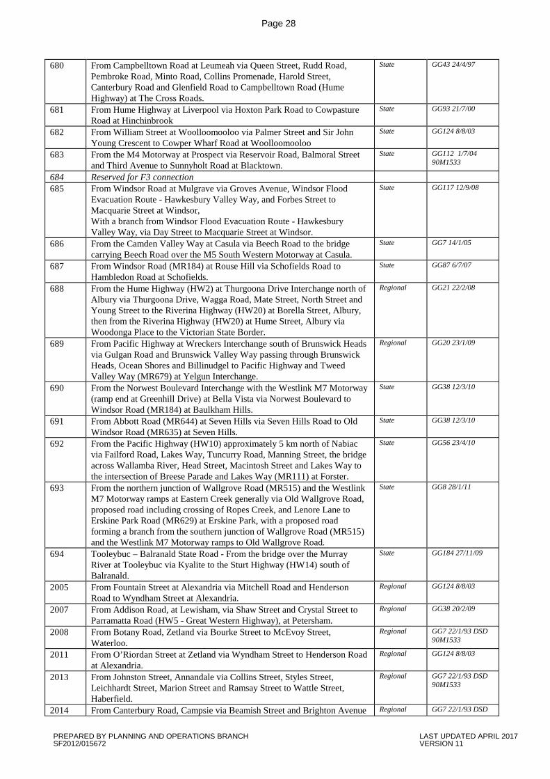
Page 28
680 From Campbelltown Road at Leumeah via Queen Street, Rudd Road, Pembroke Road, Minto Road, Collins Promenade, Harold Street, Canterbury Road and Glenfield Road to Campbelltown Road (Hume Highway) at The Cross Roads.
State GG43 24/4/97
681 From Hume Highway at Liverpool via Hoxton Park Road to Cowpasture Road at Hinchinbrook
State GG93 21/7/00
682 From William Street at Woolloomooloo via Palmer Street and Sir John Young Crescent to Cowper Wharf Road at Woolloomooloo
State GG124 8/8/03
683 From the M4 Motorway at Prospect via Reservoir Road, Balmoral Street and Third Avenue to Sunnyholt Road at Blacktown.
State GG112 1/7/04 90M1533
684 Reserved for F3 connection
685 From Windsor Road at Mulgrave via Groves Avenue, Windsor Flood Evacuation Route - Hawkesbury Valley Way, and Forbes Street to Macquarie Street at Windsor, With a branch from Windsor Flood Evacuation Route - Hawkesbury Valley Way, via Day Street to Macquarie Street at Windsor.
State GG117 12/9/08
686 From the Camden Valley Way at Casula via Beech Road to the bridge carrying Beech Road over the M5 South Western Motorway at Casula.
State GG7 14/1/05
687 From Windsor Road (MR184) at Rouse Hill via Schofields Road to Hambledon Road at Schofields.
State GG87 6/7/07
688 From the Hume Highway (HW2) at Thurgoona Drive Interchange north of Albury via Thurgoona Drive, Wagga Road, Mate Street, North Street and Young Street to the Riverina Highway (HW20) at Borella Street, Albury, then from the Riverina Highway (HW20) at Hume Street, Albury via Woodonga Place to the Victorian State Border.
Regional GG21 22/2/08
689 From Pacific Highway at Wreckers Interchange south of Brunswick Heads via Gulgan Road and Brunswick Valley Way passing through Brunswick Heads, Ocean Shores and Billinudgel to Pacific Highway and Tweed Valley Way (MR679) at Yelgun Interchange.
Regional GG20 23/1/09
690 From the Norwest Boulevard Interchange with the Westlink M7 Motorway (ramp end at Greenhill Drive) at Bella Vista via Norwest Boulevard to Windsor Road (MR184) at Baulkham Hills.
State GG38 12/3/10
691 From Abbott Road (MR644) at Seven Hills via Seven Hills Road to Old Windsor Road (MR635) at Seven Hills.
State GG38 12/3/10
692 From the Pacific Highway (HW10) approximately 5 km north of Nabiac via Failford Road, Lakes Way, Tuncurry Road, Manning Street, the bridge across Wallamba River, Head Street, Macintosh Street and Lakes Way to the intersection of Breese Parade and Lakes Way (MR111) at Forster.
State GG56 23/4/10
693 From the northern junction of Wallgrove Road (MR515) and the Westlink M7 Motorway ramps at Eastern Creek generally via Old Wallgrove Road, proposed road including crossing of Ropes Creek, and Lenore Lane to Erskine Park Road (MR629) at Erskine Park, with a proposed road forming a branch from the southern junction of Wallgrove Road (MR515) and the Westlink M7 Motorway ramps to Old Wallgrove Road.
State GG8 28/1/11
694 Tooleybuc – Balranald State Road - From the bridge over the Murray River at Tooleybuc via Kyalite to the Sturt Highway (HW14) south of Balranald.
State GG184 27/11/09
2005 From Fountain Street at Alexandria via Mitchell Road and Henderson Road to Wyndham Street at Alexandria.
Regional GG124 8/8/03
2007 From Addison Road, at Lewisham, via Shaw Street and Crystal Street to Parramatta Road (HW5 - Great Western Highway), at Petersham.
Regional GG38 20/2/09
2008 From Botany Road, Zetland via Bourke Street to McEvoy Street, Waterloo.
Regional GG7 22/1/93 DSD 90M1533
2011 From O’Riordan Street at Zetland via Wyndham Street to Henderson Road at Alexandria.
Regional GG124 8/8/03
2013 From Johnston Street, Annandale via Collins Street, Styles Street, Leichhardt Street, Marion Street and Ramsay Street to Wattle Street, Haberfield.
Regional GG7 22/1/93 DSD 90M1533
2014 From Canterbury Road, Campsie via Beamish Street and Brighton Avenue Regional GG7 22/1/93 DSD
PREPARED BY PLANNING AND OPERATIONS BRANCH LAST UPDATED APRIL 2017 SF2012/015672 VERSION 11
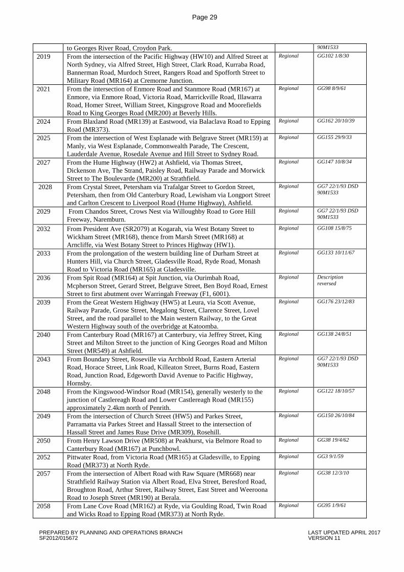
Page 29
to Georges River Road, Croydon Park. 90M1533
2019 From the intersection of the Pacific Highway (HW10) and Alfred Street at North Sydney, via Alfred Street, High Street, Clark Road, Kurraba Road, Bannerman Road, Murdoch Street, Rangers Road and Spofforth Street to Military Road (MR164) at Cremorne Junction.
Regional GG102 1/8/30
2021 From the intersection of Enmore Road and Stanmore Road (MR167) at Enmore, via Enmore Road, Victoria Road, Marrickville Road, Illawarra Road, Homer Street, William Street, Kingsgrove Road and Moorefields Road to King Georges Road (MR200) at Beverly Hills.
Regional GG98 8/9/61
2024 From Blaxland Road (MR139) at Eastwood, via Balaclava Road to Epping Road (MR373).
Regional GG162 20/10/39
2025 From the intersection of West Esplanade with Belgrave Street (MR159) at Manly, via West Esplanade, Commonwealth Parade, The Crescent, Lauderdale Avenue, Rosedale Avenue and Hill Street to Sydney Road.
Regional GG155 29/9/33
2027 From the Hume Highway (HW2) at Ashfield, via Thomas Street, Dickenson Ave, The Strand, Paisley Road, Railway Parade and Morwick Street to The Boulevarde (MR200) at Strathfield.
Regional GG147 10/8/34
2028 From Crystal Street, Petersham via Trafalgar Street to Gordon Street, Petersham, then from Old Canterbury Road, Lewisham via Longport Street and Carlton Crescent to Liverpool Road (Hume Highway), Ashfield.
Regional GG7 22/1/93 DSD 90M1533
2029 From Chandos Street, Crows Nest via Willoughby Road to Gore Hill Freeway, Naremburn.
Regional GG7 22/1/93 DSD 90M1533
2032 From President Ave (SR2079) at Kogarah, via West Botany Street to Wickham Street (MR168), thence from Marsh Street (MR168) at Arncliffe, via West Botany Street to Princes Highway (HW1).
Regional GG108 15/8/75
2033 From the prolongation of the western building line of Durham Street at Hunters Hill, via Church Street, Gladesville Road, Ryde Road, Monash Road to Victoria Road (MR165) at Gladesville.
Regional GG133 10/11/67
2036 From Spit Road (MR164) at Spit Junction, via Ourimbah Road, Mcpherson Street, Gerard Street, Belgrave Street, Ben Boyd Road, Ernest Street to first abutment over Warringah Freeway (F1, 6001).
Regional Description reversed
2039 From the Great Western Highway (HW5) at Leura, via Scott Avenue, Railway Parade, Grose Street, Megalong Street, Clarence Street, Lovel Street, and the road parallel to the Main western Railway, to the Great Western Highway south of the overbridge at Katoomba.
Regional GG176 23/12/83
2040 From Canterbury Road (MR167) at Canterbury, via Jeffrey Street, King Street and Milton Street to the junction of King Georges Road and Milton Street (MR549) at Ashfield.
Regional GG138 24/8/51
2043 From Boundary Street, Roseville via Archbold Road, Eastern Arterial Road, Horace Street, Link Road, Killeaton Street, Burns Road, Eastern Road, Junction Road, Edgeworth David Avenue to Pacific Highway, Hornsby.
Regional GG7 22/1/93 DSD 90M1533
2048 From the Kingswood-Windsor Road (MR154), generally westerly to the junction of Castlereagh Road and Lower Castlereagh Road (MR155) approximately 2.4km north of Penrith.
Regional GG122 18/10/57
2049 From the intersection of Church Street (HW5) and Parkes Street, Parramatta via Parkes Street and Hassall Street to the intersection of Hassall Street and James Ruse Drive (MR309), Rosehill.
Regional GG150 26/10/84
2050 From Henry Lawson Drive (MR508) at Peakhurst, via Belmore Road to Canterbury Road (MR167) at Punchbowl.
Regional GG38 19/4/62
2052 Pittwater Road, from Victoria Road (MR165) at Gladesville, to Epping Road (MR373) at North Ryde.
Regional GG3 9/1/59
2057 From the intersection of Albert Road with Raw Square (MR668) near Strathfield Railway Station via Albert Road, Elva Street, Beresford Road, Broughton Road, Arthur Street, Railway Street, East Street and Weeroona Road to Joseph Street (MR190) at Berala.
Regional GG38 12/3/10
2058 From Lane Cove Road (MR162) at Ryde, via Goulding Road, Twin Road and Wicks Road to Epping Road (MR373) at North Ryde.
Regional GG95 1/9/61
PREPARED BY PLANNING AND OPERATIONS BRANCH LAST UPDATED APRIL 2017 SF2012/015672 VERSION 11
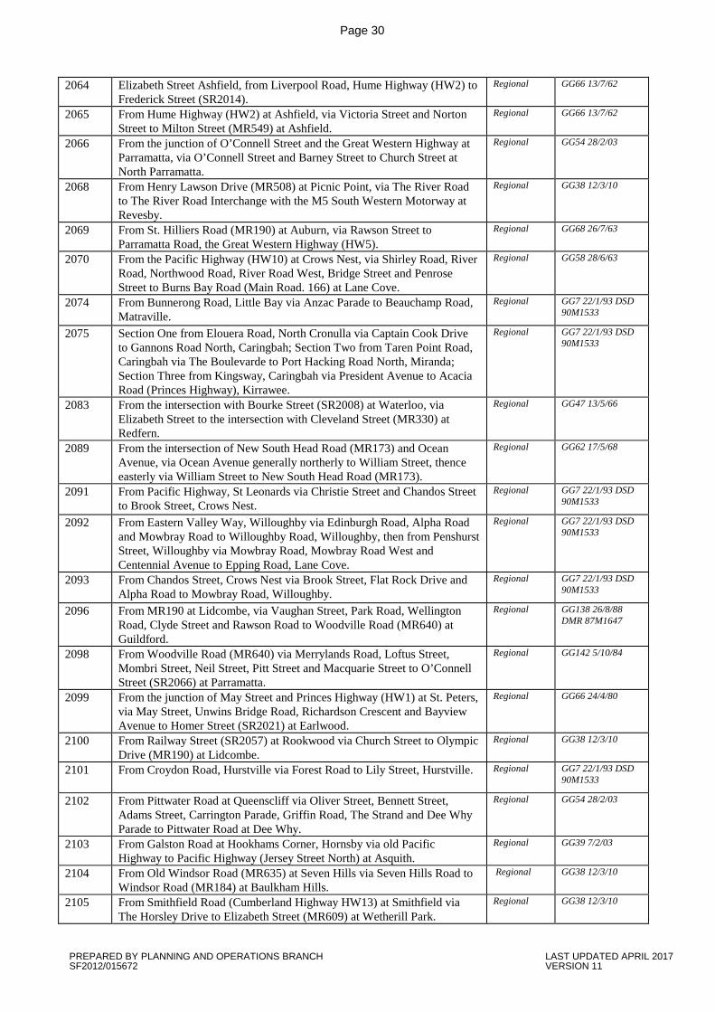
Page 30
2064 Elizabeth Street Ashfield, from Liverpool Road, Hume Highway (HW2) to Frederick Street (SR2014).
Regional GG66 13/7/62
2065 From Hume Highway (HW2) at Ashfield, via Victoria Street and Norton Street to Milton Street (MR549) at Ashfield.
Regional GG66 13/7/62
2066 From the junction of O’Connell Street and the Great Western Highway at Parramatta, via O’Connell Street and Barney Street to Church Street at North Parramatta.
Regional GG54 28/2/03
2068 From Henry Lawson Drive (MR508) at Picnic Point, via The River Road to The River Road Interchange with the M5 South Western Motorway at Revesby.
Regional GG38 12/3/10
2069 From St. Hilliers Road (MR190) at Auburn, via Rawson Street to Parramatta Road, the Great Western Highway (HW5).
Regional GG68 26/7/63
2070 From the Pacific Highway (HW10) at Crows Nest, via Shirley Road, River Road, Northwood Road, River Road West, Bridge Street and Penrose Street to Burns Bay Road (Main Road. 166) at Lane Cove.
Regional GG58 28/6/63
2074 From Bunnerong Road, Little Bay via Anzac Parade to Beauchamp Road, Matraville.
Regional GG7 22/1/93 DSD 90M1533
2075 Section One from Elouera Road, North Cronulla via Captain Cook Drive to Gannons Road North, Caringbah; Section Two from Taren Point Road, Caringbah via The Boulevarde to Port Hacking Road North, Miranda; Section Three from Kingsway, Caringbah via President Avenue to Acacia Road (Princes Highway), Kirrawee.
Regional GG7 22/1/93 DSD 90M1533
2083 From the intersection with Bourke Street (SR2008) at Waterloo, via Elizabeth Street to the intersection with Cleveland Street (MR330) at Redfern.
Regional GG47 13/5/66
2089 From the intersection of New South Head Road (MR173) and Ocean Avenue, via Ocean Avenue generally northerly to William Street, thence easterly via William Street to New South Head Road (MR173).
Regional GG62 17/5/68
2091 From Pacific Highway, St Leonards via Christie Street and Chandos Street to Brook Street, Crows Nest.
Regional GG7 22/1/93 DSD 90M1533
2092 From Eastern Valley Way, Willoughby via Edinburgh Road, Alpha Road and Mowbray Road to Willoughby Road, Willoughby, then from Penshurst Street, Willoughby via Mowbray Road, Mowbray Road West and Centennial Avenue to Epping Road, Lane Cove.
Regional GG7 22/1/93 DSD 90M1533
2093 From Chandos Street, Crows Nest via Brook Street, Flat Rock Drive and Alpha Road to Mowbray Road, Willoughby.
Regional GG7 22/1/93 DSD 90M1533
2096 From MR190 at Lidcombe, via Vaughan Street, Park Road, Wellington Road, Clyde Street and Rawson Road to Woodville Road (MR640) at Guildford.
Regional GG138 26/8/88 DMR 87M1647
2098 From Woodville Road (MR640) via Merrylands Road, Loftus Street, Mombri Street, Neil Street, Pitt Street and Macquarie Street to O’Connell Street (SR2066) at Parramatta.
Regional GG142 5/10/84
2099 From the junction of May Street and Princes Highway (HW1) at St. Peters, via May Street, Unwins Bridge Road, Richardson Crescent and Bayview Avenue to Homer Street (SR2021) at Earlwood.
Regional GG66 24/4/80
2100 From Railway Street (SR2057) at Rookwood via Church Street to Olympic Drive (MR190) at Lidcombe.
Regional GG38 12/3/10
2101 From Croydon Road, Hurstville via Forest Road to Lily Street, Hurstville. Regional GG7 22/1/93 DSD 90M1533
2102 From Pittwater Road at Queenscliff via Oliver Street, Bennett Street, Adams Street, Carrington Parade, Griffin Road, The Strand and Dee Why Parade to Pittwater Road at Dee Why.
Regional GG54 28/2/03
2103 From Galston Road at Hookhams Corner, Hornsby via old Pacific Highway to Pacific Highway (Jersey Street North) at Asquith.
Regional GG39 7/2/03
2104 From Old Windsor Road (MR635) at Seven Hills via Seven Hills Road to Windsor Road (MR184) at Baulkham Hills.
Regional GG38 12/3/10
2105 From Smithfield Road (Cumberland Highway HW13) at Smithfield via The Horsley Drive to Elizabeth Street (MR609) at Wetherill Park.
Regional GG38 12/3/10
PREPARED BY PLANNING AND OPERATIONS BRANCH LAST UPDATED APRIL 2017 SF2012/015672 VERSION 11
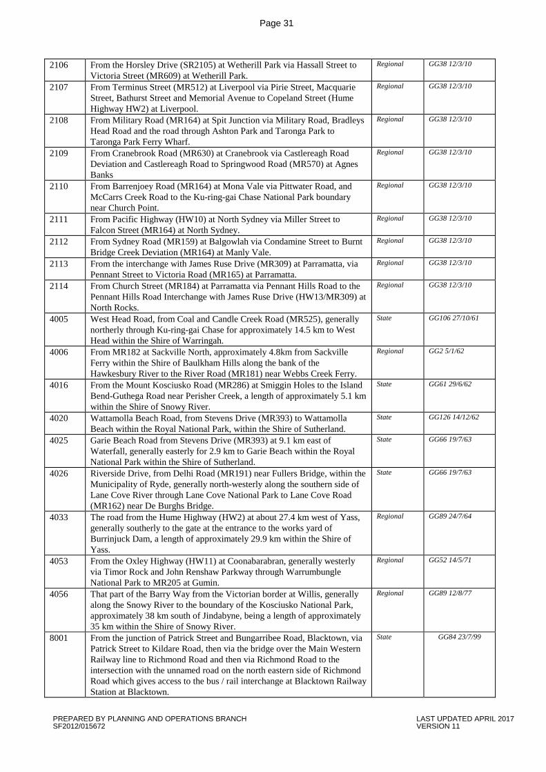
Page 31
2106 From the Horsley Drive (SR2105) at Wetherill Park via Hassall Street to Victoria Street (MR609) at Wetherill Park.
Regional GG38 12/3/10
2107 From Terminus Street (MR512) at Liverpool via Pirie Street, Macquarie Street, Bathurst Street and Memorial Avenue to Copeland Street (Hume Highway HW2) at Liverpool.
Regional GG38 12/3/10
2108 From Military Road (MR164) at Spit Junction via Military Road, Bradleys Head Road and the road through Ashton Park and Taronga Park to Taronga Park Ferry Wharf.
Regional GG38 12/3/10
2109 From Cranebrook Road (MR630) at Cranebrook via Castlereagh Road Deviation and Castlereagh Road to Springwood Road (MR570) at Agnes Banks
Regional GG38 12/3/10
2110 From Barrenjoey Road (MR164) at Mona Vale via Pittwater Road, and McCarrs Creek Road to the Ku-ring-gai Chase National Park boundary near Church Point.
Regional GG38 12/3/10
2111 From Pacific Highway (HW10) at North Sydney via Miller Street to Falcon Street (MR164) at North Sydney.
Regional GG38 12/3/10
2112 From Sydney Road (MR159) at Balgowlah via Condamine Street to Burnt Bridge Creek Deviation (MR164) at Manly Vale.
Regional GG38 12/3/10
2113 From the interchange with James Ruse Drive (MR309) at Parramatta, via Pennant Street to Victoria Road (MR165) at Parramatta.
Regional GG38 12/3/10
2114 From Church Street (MR184) at Parramatta via Pennant Hills Road to the Pennant Hills Road Interchange with James Ruse Drive (HW13/MR309) at North Rocks.
Regional GG38 12/3/10
4005 West Head Road, from Coal and Candle Creek Road (MR525), generally northerly through Ku-ring-gai Chase for approximately 14.5 km to West Head within the Shire of Warringah.
State GG106 27/10/61
4006 From MR182 at Sackville North, approximately 4.8km from Sackville Ferry within the Shire of Baulkham Hills along the bank of the Hawkesbury River to the River Road (MR181) near Webbs Creek Ferry.
Regional GG2 5/1/62
4016 From the Mount Kosciusko Road (MR286) at Smiggin Holes to the Island Bend-Guthega Road near Perisher Creek, a length of approximately 5.1 km within the Shire of Snowy River.
State GG61 29/6/62
4020 Wattamolla Beach Road, from Stevens Drive (MR393) to Wattamolla Beach within the Royal National Park, within the Shire of Sutherland.
State GG126 14/12/62
4025 Garie Beach Road from Stevens Drive (MR393) at 9.1 km east of Waterfall, generally easterly for 2.9 km to Garie Beach within the Royal National Park within the Shire of Sutherland.
State GG66 19/7/63
4026 Riverside Drive, from Delhi Road (MR191) near Fullers Bridge, within the Municipality of Ryde, generally north-westerly along the southern side of Lane Cove River through Lane Cove National Park to Lane Cove Road (MR162) near De Burghs Bridge.
State GG66 19/7/63
4033 The road from the Hume Highway (HW2) at about 27.4 km west of Yass, generally southerly to the gate at the entrance to the works yard of Burrinjuck Dam, a length of approximately 29.9 km within the Shire of Yass.
Regional GG89 24/7/64
4053 From the Oxley Highway (HW11) at Coonabarabran, generally westerly via Timor Rock and John Renshaw Parkway through Warrumbungle National Park to MR205 at Gumin.
Regional GG52 14/5/71
4056 That part of the Barry Way from the Victorian border at Willis, generally along the Snowy River to the boundary of the Kosciusko National Park, approximately 38 km south of Jindabyne, being a length of approximately 35 km within the Shire of Snowy River.
Regional GG89 12/8/77
8001 From the junction of Patrick Street and Bungarribee Road, Blacktown, via Patrick Street to Kildare Road, then via the bridge over the Main Western Railway line to Richmond Road and then via Richmond Road to the intersection with the unnamed road on the north eastern side of Richmond Road which gives access to the bus / rail interchange at Blacktown Railway Station at Blacktown.
State GG84 23/7/99
PREPARED BY PLANNING AND OPERATIONS BRANCH LAST UPDATED APRIL 2017 SF2012/015672 VERSION 11
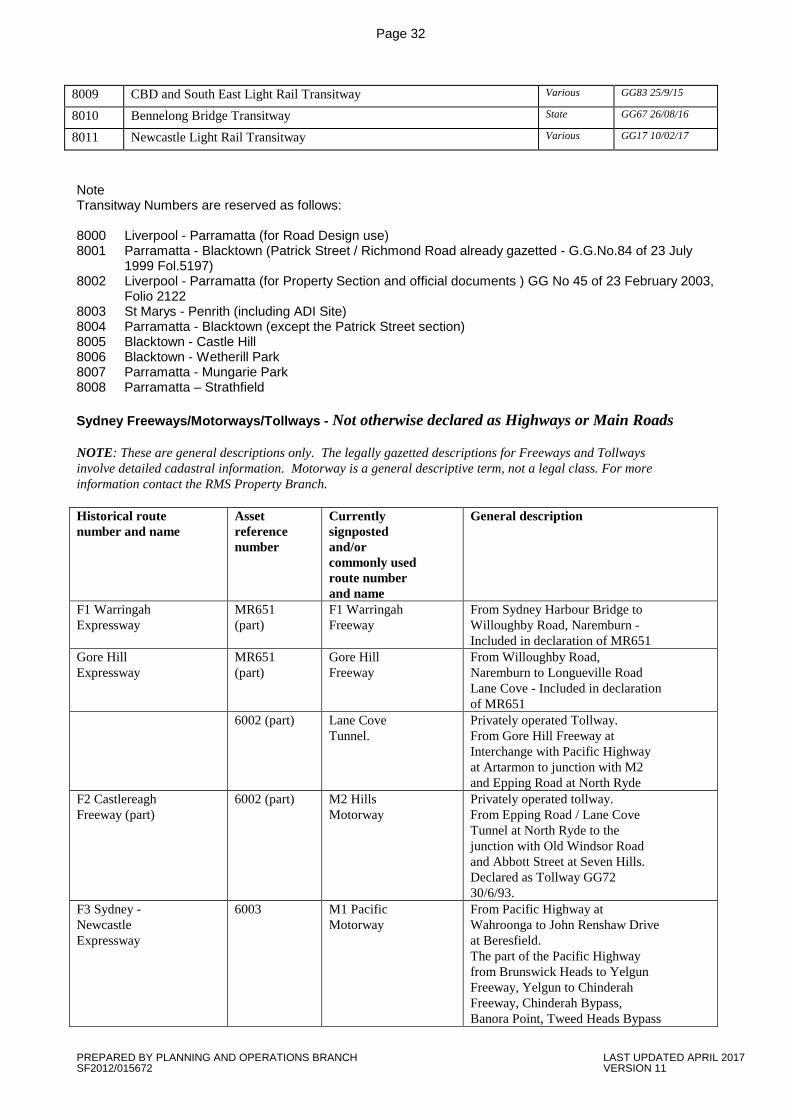
Page 32
8009 CBD and South East Light Rail Transitway Various GG83 25/9/15
8010 Bennelong Bridge Transitway State GG67 26/08/16
8011 Newcastle Light Rail Transitway Various GG17 10/02/17
Note Transitway Numbers are reserved as follows: 8000 Liverpool - Parramatta (for Road Design use) 8001 Parramatta - Blacktown (Patrick Street / Richmond Road already gazetted - G.G.No.84 of 23 July
1999 Fol.5197) 8002 Liverpool - Parramatta (for Property Section and official documents ) GG No 45 of 23 February 2003,
Folio 2122 8003 St Marys - Penrith (including ADI Site) 8004 Parramatta - Blacktown (except the Patrick Street section) 8005 Blacktown - Castle Hill 8006 Blacktown - Wetherill Park 8007 Parramatta - Mungarie Park 8008 Parramatta – Strathfield Sydney Freeways/Motorways/Tollways - Not otherwise declared as Highways or Main Roads NOTE: These are general descriptions only. The legally gazetted descriptions for Freeways and Tollways involve detailed cadastral information. Motorway is a general descriptive term, not a legal class. For more information contact the RMS Property Branch. Historical route number and name
Asset reference number
Currently signposted and/or commonly used route number and name
General description
F1 Warringah Expressway
MR651 (part)
F1 Warringah Freeway
From Sydney Harbour Bridge to Willoughby Road, Naremburn - Included in declaration of MR651
Gore Hill Expressway
MR651 (part)
Gore Hill Freeway
From Willoughby Road, Naremburn to Longueville Road Lane Cove - Included in declaration of MR651
6002 (part) Lane Cove Tunnel.
Privately operated Tollway. From Gore Hill Freeway at Interchange with Pacific Highway at Artarmon to junction with M2 and Epping Road at North Ryde
F2 Castlereagh Freeway (part)
6002 (part) M2 Hills Motorway
Privately operated tollway. From Epping Road / Lane Cove Tunnel at North Ryde to the junction with Old Windsor Road and Abbott Street at Seven Hills. Declared as Tollway GG72 30/6/93.
F3 Sydney - Newcastle Expressway
6003 M1 Pacific Motorway
From Pacific Highway at Wahroonga to John Renshaw Drive at Beresfield. The part of the Pacific Highway from Brunswick Heads to Yelgun Freeway, Yelgun to Chinderah Freeway, Chinderah Bypass, Banora Point, Tweed Heads Bypass
PREPARED BY PLANNING AND OPERATIONS BRANCH LAST UPDATED APRIL 2017 SF2012/015672 VERSION 11
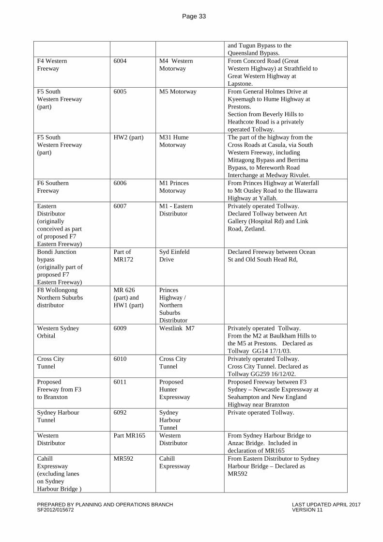
Page 33
and Tugun Bypass to the Queensland Bypass.
F4 Western Freeway
6004 M4 Western Motorway
From Concord Road (Great Western Highway) at Strathfield to Great Western Highway at Lapstone.
F5 South Western Freeway (part)
6005 M5 Motorway From General Holmes Drive at Kyeemagh to Hume Highway at Prestons. Section from Beverly Hills to Heathcote Road is a privately operated Tollway.
F5 South Western Freeway (part)
HW2 (part) M31 Hume Motorway
The part of the highway from the Cross Roads at Casula, via South Western Freeway, including Mittagong Bypass and Berrima Bypass, to Mereworth Road Interchange at Medway Rivulet.
F6 Southern Freeway
6006 M1 Princes Motorway
From Princes Highway at Waterfall to Mt Ousley Road to the Illawarra Highway at Yallah.
Eastern Distributor (originally conceived as part of proposed F7 Eastern Freeway)
6007 M1 - Eastern Distributor
Privately operated Tollway. Declared Tollway between Art Gallery (Hospital Rd) and Link Road, Zetland.
Bondi Junction bypass (originally part of proposed F7 Eastern Freeway)
Part of MR172
Syd Einfeld Drive
Declared Freeway between Ocean St and Old South Head Rd,
F8 Wollongong Northern Suburbs distributor
MR 626 (part) and HW1 (part)
Princes Highway / Northern Suburbs Distributor
Western Sydney Orbital
6009 Westlink M7 Privately operated Tollway. From the M2 at Baulkham Hills to the M5 at Prestons. Declared as Tollway GG14 17/1/03.
Cross City Tunnel
6010 Cross City Tunnel
Privately operated Tollway. Cross City Tunnel. Declared as Tollway GG259 16/12/02.
Proposed Freeway from F3 to Branxton
6011 Proposed Hunter Expressway
Proposed Freeway between F3 Sydney – Newcastle Expressway at Seahampton and New England Highway near Branxton
Sydney Harbour Tunnel
6092 Sydney Harbour Tunnel
Private operated Tollway.
Western Distributor
Part MR165 Western Distributor
From Sydney Harbour Bridge to Anzac Bridge. Included in declaration of MR165
Cahill Expressway (excluding lanes on Sydney Harbour Bridge )
MR592 Cahill Expressway
From Eastern Distributor to Sydney Harbour Bridge – Declared as MR592
PREPARED BY PLANNING AND OPERATIONS BRANCH LAST UPDATED APRIL 2017 SF2012/015672 VERSION 11
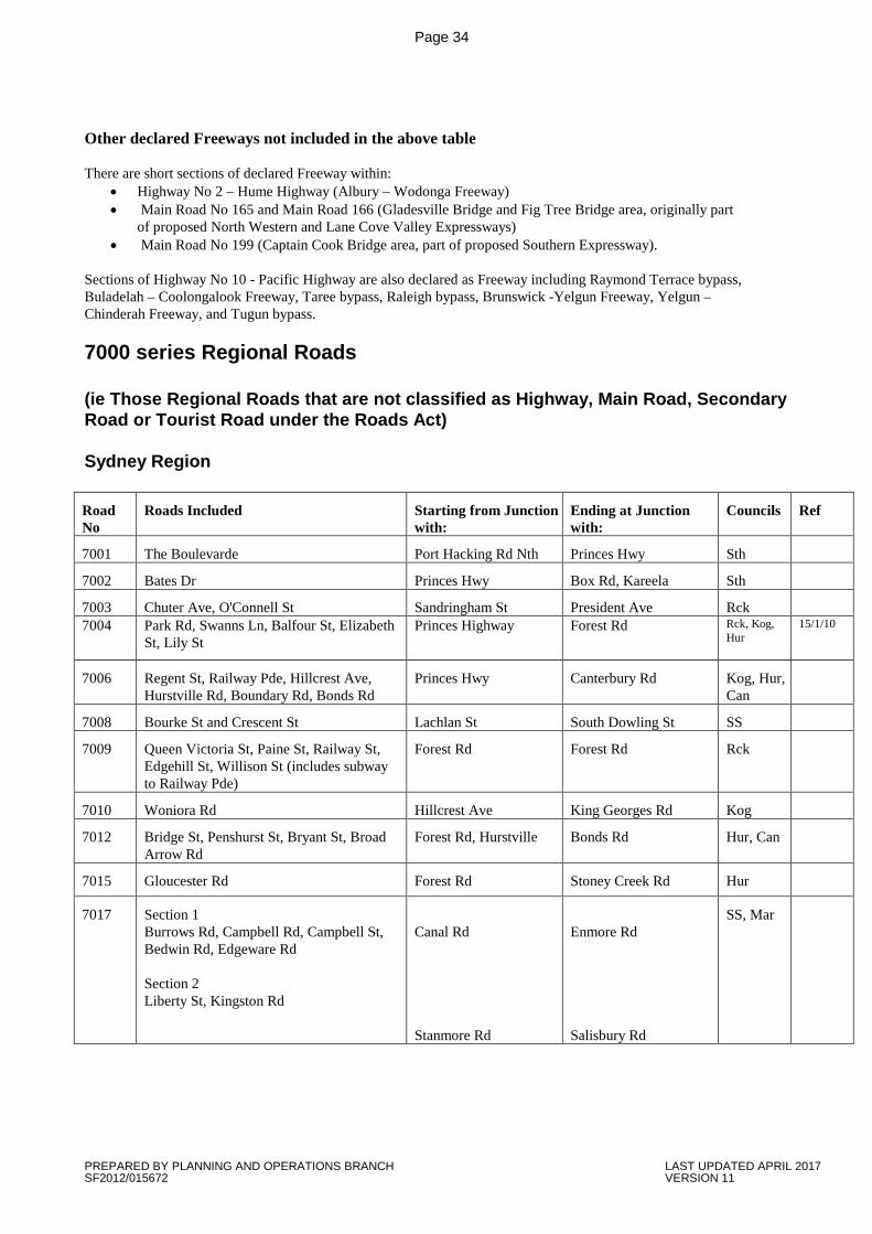
Page 34
Other declared Freeways not included in the above table There are short sections of declared Freeway within:
• Highway No 2 – Hume Highway (Albury – Wodonga Freeway) • Main Road No 165 and Main Road 166 (Gladesville Bridge and Fig Tree Bridge area, originally part
of proposed North Western and Lane Cove Valley Expressways) • Main Road No 199 (Captain Cook Bridge area, part of proposed Southern Expressway).
Sections of Highway No 10 - Pacific Highway are also declared as Freeway including Raymond Terrace bypass, Buladelah – Coolongalook Freeway, Taree bypass, Raleigh bypass, Brunswick -Yelgun Freeway, Yelgun – Chinderah Freeway, and Tugun bypass. 7000 series Regional Roads (ie Those Regional Roads that are not classified as Highway, Main Road, Secondary Road or Tourist Road under the Roads Act) Sydney Region Road No
Roads Included Starting from Junction with:
Ending at Junction with:
Councils Ref
7001 The Boulevarde Port Hacking Rd Nth Princes Hwy Sth
7002 Bates Dr Princes Hwy Box Rd, Kareela Sth
7003 Chuter Ave, O'Connell St Sandringham St President Ave Rck 7004 Park Rd, Swanns Ln, Balfour St, Elizabeth
St, Lily St Princes Highway Forest Rd Rck, Kog,
Hur 15/1/10
7006 Regent St, Railway Pde, Hillcrest Ave, Hurstville Rd, Boundary Rd, Bonds Rd
Princes Hwy Canterbury Rd Kog, Hur, Can
7008 Bourke St and Crescent St Lachlan St South Dowling St SS
7009 Queen Victoria St, Paine St, Railway St, Edgehill St, Willison St (includes subway to Railway Pde)
Forest Rd Forest Rd Rck
7010 Woniora Rd Hillcrest Ave King Georges Rd Kog
7012 Bridge St, Penshurst St, Bryant St, Broad Arrow Rd
Forest Rd, Hurstville Bonds Rd Hur, Can
7015 Gloucester Rd Forest Rd Stoney Creek Rd Hur
7017 Section 1 Burrows Rd, Campbell Rd, Campbell St, Bedwin Rd, Edgeware Rd Section 2 Liberty St, Kingston Rd
Canal Rd Stanmore Rd
Enmore Rd Salisbury Rd
SS, Mar
PREPARED BY PLANNING AND OPERATIONS BRANCH LAST UPDATED APRIL 2017 SF2012/015672 VERSION 11
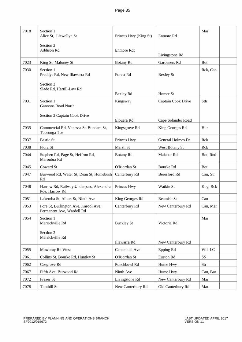
Page 35
7018 Section 1 Alice St, Llewellyn St Section 2 Addison Rd
Princes Hwy (King St) Enmore Rdt
Enmore Rd Livingstone Rd
Mar
7023 King St, Maloney St Botany Rd Gardeners Rd Bot
7030 Section 1 Preddys Rd, New Illawarra Rd Section 2 Slade Rd, Hartill-Law Rd
Forest Rd Bexley Rd
Bexley St Homer St
Rck, Can
7031 Section 1 Gannons Road North Section 2 Captain Cook Drive
Kingsway Elouera Rd
Captain Cook Drive Cape Solander Road
Sth
7035 Commercial Rd, Vanessa St, Bundara St, Tooronga Tce
Kingsgrove Rd King Georges Rd Hur
7037 Bestic St Princes Hwy General Holmes Dr Rck
7038 Flora St Marsh St West Botany St Rck
7044 Stephen Rd, Page St, Heffron Rd, Maroubra Rd
Botany Rd Malabar Rd Bot, Rnd
7045 Coward St O'Riordan St Bourke Rd Bot
7047 Burwood Rd, Water St, Dean St, Homebush Rd
Canterbury Rd Beresford Rd Can, Str
7048 Harrow Rd, Railway Underpass, Alexandra Pde, Harrow Rd
Princes Hwy Watkin St Kog, Rck
7051 Lakemba St, Albert St, Ninth Ave King Georges Rd Beamish St Can
7053 Fore St, Burlington Ave, Karool Ave, Permanent Ave, Wardell Rd
Canterbury Rd New Canterbury Rd Can, Mar
7054 Section 1 Marrickville Rd Section 2 Marrickville Rd
Buckley St Illawarra Rd
Victoria Rd New Canterbury Rd
Mar
7055 Mowbray Rd West Centennial Ave Epping Rd Wil, LC
7061 Collins St, Bourke Rd, Huntley St O'Riordan St Euston Rd SS
7062 Cosgrove Rd Punchbowl Rd Hume Hwy Str
7067 Fifth Ave, Burwood Rd Ninth Ave Hume Hwy Can, Bur
7072 Frazer St Livingstone Rd New Canterbury Rd Mar
7078 Toothill St New Canterbury Rd Old Canterbury Rd Mar
PREPARED BY PLANNING AND OPERATIONS BRANCH LAST UPDATED APRIL 2017 SF2012/015672 VERSION 11
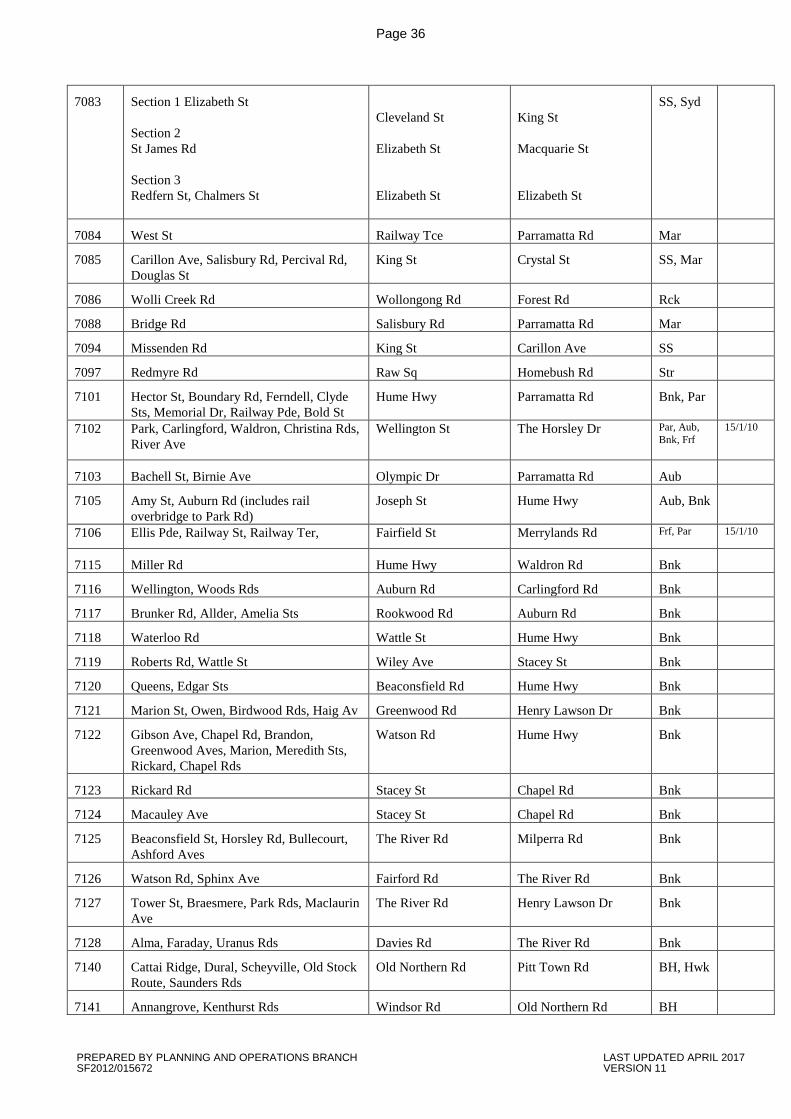
Page 36
7083 Section 1 Elizabeth St Section 2 St James Rd Section 3 Redfern St, Chalmers St
Cleveland St Elizabeth St Elizabeth St
King St Macquarie St Elizabeth St
SS, Syd
7084 West St Railway Tce Parramatta Rd Mar
7085 Carillon Ave, Salisbury Rd, Percival Rd, Douglas St
King St Crystal St SS, Mar
7086 Wolli Creek Rd Wollongong Rd Forest Rd Rck
7088 Bridge Rd Salisbury Rd Parramatta Rd Mar
7094 Missenden Rd King St Carillon Ave SS
7097 Redmyre Rd Raw Sq Homebush Rd Str
7101 Hector St, Boundary Rd, Ferndell, Clyde Sts, Memorial Dr, Railway Pde, Bold St
Hume Hwy Parramatta Rd Bnk, Par
7102 Park, Carlingford, Waldron, Christina Rds, River Ave
Wellington St The Horsley Dr Par, Aub, Bnk, Frf
15/1/10
7103 Bachell St, Birnie Ave Olympic Dr Parramatta Rd Aub
7105 Amy St, Auburn Rd (includes rail overbridge to Park Rd)
Joseph St Hume Hwy Aub, Bnk
7106 Ellis Pde, Railway St, Railway Ter, Fairfield St Merrylands Rd Frf, Par 15/1/10
7115 Miller Rd Hume Hwy Waldron Rd Bnk
7116 Wellington, Woods Rds Auburn Rd Carlingford Rd Bnk
7117 Brunker Rd, Allder, Amelia Sts Rookwood Rd Auburn Rd Bnk
7118 Waterloo Rd Wattle St Hume Hwy Bnk
7119 Roberts Rd, Wattle St Wiley Ave Stacey St Bnk
7120 Queens, Edgar Sts Beaconsfield Rd Hume Hwy Bnk
7121 Marion St, Owen, Birdwood Rds, Haig Av Greenwood Rd Henry Lawson Dr Bnk
7122 Gibson Ave, Chapel Rd, Brandon, Greenwood Aves, Marion, Meredith Sts, Rickard, Chapel Rds
Watson Rd Hume Hwy Bnk
7123 Rickard Rd Stacey St Chapel Rd Bnk
7124 Macauley Ave Stacey St Chapel Rd Bnk
7125 Beaconsfield St, Horsley Rd, Bullecourt, Ashford Aves
The River Rd Milperra Rd Bnk
7126 Watson Rd, Sphinx Ave Fairford Rd The River Rd Bnk
7127 Tower St, Braesmere, Park Rds, Maclaurin Ave
The River Rd Henry Lawson Dr Bnk
7128 Alma, Faraday, Uranus Rds Davies Rd The River Rd Bnk
7140 Cattai Ridge, Dural, Scheyville, Old Stock Route, Saunders Rds
Old Northern Rd Pitt Town Rd BH, Hwk
7141 Annangrove, Kenthurst Rds Windsor Rd Old Northern Rd BH
PREPARED BY PLANNING AND OPERATIONS BRANCH LAST UPDATED APRIL 2017 SF2012/015672 VERSION 11
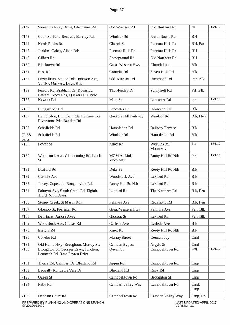
Page 37
7142 Samantha Riley Drive, Glenhaven Rd Old Windsor Rd Old Northern Rd Hil 15/1/10
7143 Cook St, Park, Renown, Barclay Rds Windsor Rd North Rocks Rd BH
7144 North Rocks Rd Church St Pennant Hills Rd BH, Par
7145 Jenkins, Oakes, Aiken Rds Pennant Hills Rd Pennant Hills Rd BH
7146 Gilbert Rd Showground Rd Old Northern Rd BH
7150 Blacktown Rd Great Western Hwy Church Lane Blk
7151 Best Rd Cornelia Rd Seven Hills Rd Blk
7152 Fitzwilliam, Station Rds, Johnson Ave, Vardys, Quakers, Davis Rds
Old Windsor Rd Richmond Rd Par, Blk
7153 Ferrers Rd, Brabham Dr, Doonside, Eastern, Knox Rds, Quakers Hill Pkw
The Horsley Dr Sunnyholt Rd Frf, Blk
7155 Newton Rd Main St Lancaster Rd Blk 15/1/10
7156 Bungarribee Rd Lancaster St Doonside Rd Blk
7157 Hambledon, Burdekin Rds, Railway Ter, Riverstone Pde, Bandon Rd
Quakers Hill Parkway Windsor Rd Blk, Hwk
7158 Schofields Rd Hambledon Rd Railway Terrace Blk
(7158 part)
Schofields Rd Windsor Rd Hambledon Rd Blk
7159 Power St Knox Rd Westlink M7 Motorway
Blk 15/1/10
7160 Woodstock Ave, Glendenning Rd, Lamb St
M7 West Link Motorway
Rooty Hill Rd Nth Blk 15/1/10
7161 Luxford Rd Duke St Rooty Hill Rd Nth Blk
7162 Carlisle Ave Woodstock Ave Luxford Rd Blk
7163 Jersey, Copeland, Bougainville Rds Rooty Hill Rd Nth Luxford Rd Blk
7164 Palmyra Ave, South Creek Rd, Eighth, Third, Ninth Aves
Luxford Rd The Northern Rd Blk, Pen
7166 Stoney Creek, St Marys Rds Palmyra Ave Richmond Rd Blk, Pen
7167 Glossop St, Forrester Rd Great Western Hwy Palmyra Ave Pen, Blk
7168 Debrincat, Aurora Aves Glossop St Luxford Rd Pen, Blk
7169 Woodstock Ave, Clucas Rd Carlisle Ave Carlisle Ave Blk
7170 Eastern Rd Knox Rd Rooty Hill Rd Nth Blk
7180 Cawdor Rd Murray Street Council bdy Cmd
7181 Old Hume Hwy, Broughton, Murray Sts Camden Bypass Argyle St Cmd 7190 Broughton St, Georges River, Junction,
Leumeah Rd, Rose Payten Drive Queen St Campbelltown Rd Cmp 15/1/10
7191 Therry Rd, Gilchrist Dr, Blaxland Rd Appin Rd Campbelltown Rd Cmp
7192 Badgally Rd, Eagle Vale Dr Blaxland Rd Raby Rd Cmp
7193 Queen St Campbelltown Rd Broughton St Cmp
7194 Raby Rd Camden Valley Way Campbelltown Rd Cmd, Cmp
7195 Denham Court Rd Campbelltown Rd Camden Valley Way Cmp, Liv
PREPARED BY PLANNING AND OPERATIONS BRANCH LAST UPDATED APRIL 2017 SF2012/015672 VERSION 11

Page 38
7196 Ben Lomond Rd Campbelltown Rd Pembroke Rd Cmp 7197 Williamson, Henderson Rds Campbelltown Rd Harold St Cmp 15/1/10
7198 Cumberland, Macquarie, Fields, Atchison Rds, Railway Pde
Minto Rd Cambridge Ave Cmp
7200 Hurley St Queen St Narellan Rd Cmp
7205 Boundary Rd Windsor Rd Dural Rd BH, Hwk
7207 Freemans Reach Rd, Gorricks Lane, Kurmond, Creek Ridge, Spinks, Kurmond Rds, Wire Lane, Terrace Rd
Wilberforce Rd Bells Line of Road Hwk
7208 Argyle St, Fairey Rd, Mileham, Brabyn Sts Macquarie St Macquarie St Hwk
7209 March St East Market St Bourke St Hwk
7210 Lennox St Castlereagh Rd East Market St Hwk
7211 Bourke St Lennox St Windsor Rd Hwk
7212 Grose Vale Rd, Old Bells Line of Road Bells Line of Road Bells Line of Road Hwk
7220 Smithfield Rd Elizabeth Dr Cumberland Hwy Frf
7221 Humphries, St Johns Rds, Sackville St Edensor Rd Polding St Frf
7222 Fairfield Rd, Polding St, Prarie Vale, Restwell Rds
Woodpark Rd Cowpasture Rd Frf, Hol
7223 Lawson, Barbara Sts, Hamilton, Bulls, Richards Rds
Vine St Smithfield Rd Frf
7224 Canley Vale Rd Railway Pde Smithfield Rd Frf
7225 Bartley St Railway Pde Sackville St Frf
7226 Lansdowne Rd, Chancery, Vale, Bareena Sts
Hume Hwy Broomfield St Frf
7227 Gladstone St Cabramatta Rd St Johns Rd Frf
7228 Meadows, Edensor Rds North Liverpool Rd Cowpasture Rd Frf
7229 Mimosa Rd Smithfield Rd The Horsley Dr Frf
7230 Wetherill St Polding St Victoria St Frf
7231 Avoca, King Rds St Johns Rd Polding St Frf 7232 Fairfield, Vine, Gordon Sts Woodville Rd The Horsley Dr Frf 15/1/10
7233 Church St, Boundary Lane, Railway Pde Cabramatta Rd Lawson St Frf
7240 Copeland Rd Beecroft Rd Pennant Hills Rd Hrn
7241 Stevens, Bellamy Sts Yarrara Rd Boundary Rd Hrn
7242 New Line Rd Castle Hill Rd Boundary Rd Hrn
7243 Yarrara Rd, The Esplanade, Chilvers, Sefton Rds, Milson Pde, Malsbury, Clarke, Rds, College Cres
Pennant Hills Rd Pacific Hwy Hrn
7244 Yanko Rd, Doncaster Ave, The Comenarra Parkway
Ryde Rd Pennant Hills Rd Kur, Hrn
7245 Sherbrooke Rd, Royston Pde Edgeworth David Ave Ku-ring-gai Rd Hrn
7250 Neil, Treves Sts, Merrylands Rd Pitt St Greystanes Rd Hol
PREPARED BY PLANNING AND OPERATIONS BRANCH LAST UPDATED APRIL 2017 SF2012/015672 VERSION 11
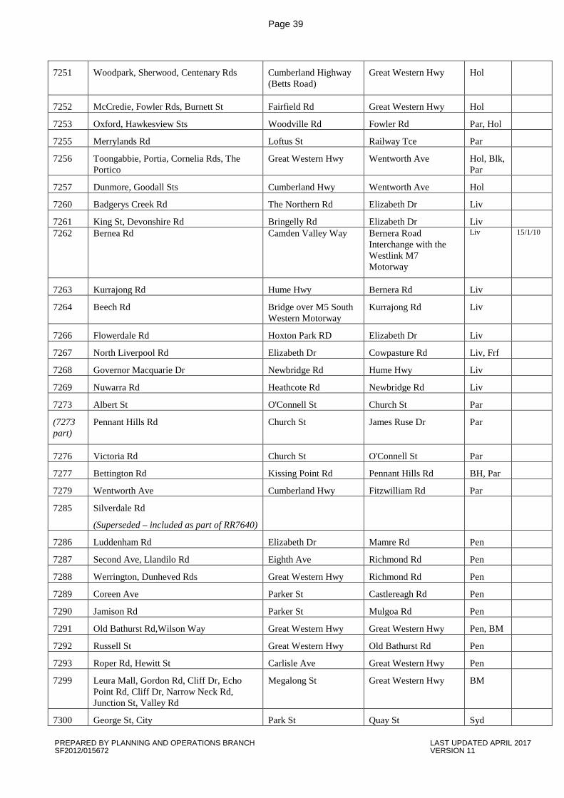
Page 39
7251
Woodpark, Sherwood, Centenary Rds Cumberland Highway (Betts Road)
Great Western Hwy Hol
7252 McCredie, Fowler Rds, Burnett St Fairfield Rd Great Western Hwy Hol
7253 Oxford, Hawkesview Sts Woodville Rd Fowler Rd Par, Hol
7255 Merrylands Rd Loftus St Railway Tce Par
7256 Toongabbie, Portia, Cornelia Rds, The Portico
Great Western Hwy Wentworth Ave Hol, Blk, Par
7257 Dunmore, Goodall Sts Cumberland Hwy Wentworth Ave Hol
7260 Badgerys Creek Rd The Northern Rd Elizabeth Dr Liv
7261 King St, Devonshire Rd Bringelly Rd Elizabeth Dr Liv 7262 Bernea Rd Camden Valley Way Bernera Road
Interchange with the Westlink M7 Motorway
Liv 15/1/10
7263 Kurrajong Rd Hume Hwy Bernera Rd Liv
7264 Beech Rd Bridge over M5 South Western Motorway
Kurrajong Rd Liv
7266 Flowerdale Rd Hoxton Park RD Elizabeth Dr Liv
7267 North Liverpool Rd Elizabeth Dr Cowpasture Rd Liv, Frf
7268 Governor Macquarie Dr Newbridge Rd Hume Hwy Liv
7269 Nuwarra Rd Heathcote Rd Newbridge Rd Liv
7273 Albert St O'Connell St Church St Par
(7273 part)
Pennant Hills Rd
Church St James Ruse Dr Par
7276 Victoria Rd Church St O'Connell St Par
7277 Bettington Rd Kissing Point Rd Pennant Hills Rd BH, Par
7279 Wentworth Ave Cumberland Hwy Fitzwilliam Rd Par
7285 Silverdale Rd
(Superseded – included as part of RR7640)
7286 Luddenham Rd Elizabeth Dr Mamre Rd Pen
7287 Second Ave, Llandilo Rd Eighth Ave Richmond Rd Pen
7288 Werrington, Dunheved Rds Great Western Hwy Richmond Rd Pen
7289 Coreen Ave Parker St Castlereagh Rd Pen
7290 Jamison Rd Parker St Mulgoa Rd Pen
7291 Old Bathurst Rd,Wilson Way Great Western Hwy Great Western Hwy Pen, BM
7292 Russell St Great Western Hwy Old Bathurst Rd Pen
7293 Roper Rd, Hewitt St Carlisle Ave Great Western Hwy Pen
7299 Leura Mall, Gordon Rd, Cliff Dr, Echo Point Rd, Cliff Dr, Narrow Neck Rd, Junction St, Valley Rd
Megalong St Great Western Hwy BM
7300 George St, City Park St Quay St Syd
PREPARED BY PLANNING AND OPERATIONS BRANCH LAST UPDATED APRIL 2017 SF2012/015672 VERSION 11
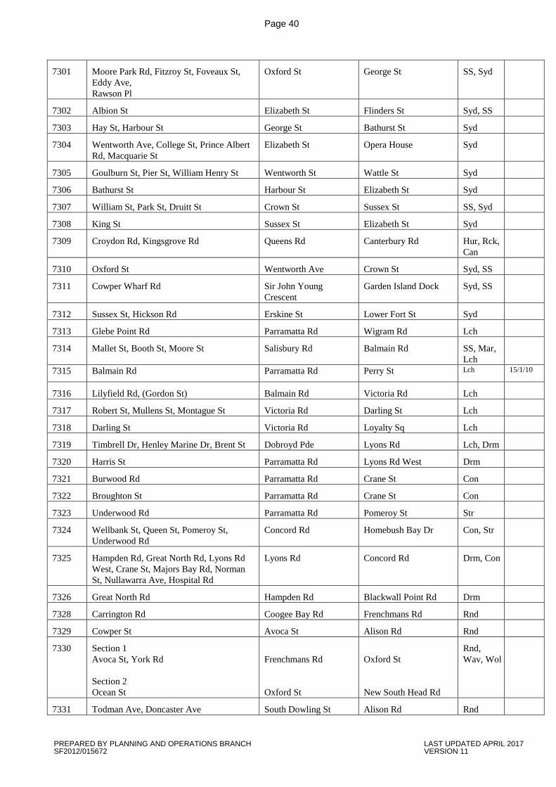
Page 40
7301 Moore Park Rd, Fitzroy St, Foveaux St, Eddy Ave, Rawson Pl
Oxford St George St SS, Syd
7302 Albion St Elizabeth St Flinders St Syd, SS
7303 Hay St, Harbour St George St Bathurst St Syd
7304 Wentworth Ave, College St, Prince Albert Rd, Macquarie St
Elizabeth St Opera House Syd
7305 Goulburn St, Pier St, William Henry St Wentworth St Wattle St Syd
7306 Bathurst St Harbour St Elizabeth St Syd
7307 William St, Park St, Druitt St Crown St Sussex St SS, Syd
7308 King St Sussex St Elizabeth St Syd
7309 Croydon Rd, Kingsgrove Rd Queens Rd Canterbury Rd Hur, Rck, Can
7310 Oxford St Wentworth Ave Crown St Syd, SS
7311 Cowper Wharf Rd Sir John Young Crescent
Garden Island Dock Syd, SS
7312 Sussex St, Hickson Rd Erskine St Lower Fort St Syd
7313 Glebe Point Rd Parramatta Rd Wigram Rd Lch
7314 Mallet St, Booth St, Moore St Salisbury Rd Balmain Rd SS, Mar, Lch
7315 Balmain Rd Parramatta Rd Perry St Lch 15/1/10
7316 Lilyfield Rd, (Gordon St) Balmain Rd Victoria Rd Lch
7317 Robert St, Mullens St, Montague St Victoria Rd Darling St Lch
7318 Darling St Victoria Rd Loyalty Sq Lch
7319 Timbrell Dr, Henley Marine Dr, Brent St Dobroyd Pde Lyons Rd Lch, Drm
7320 Harris St Parramatta Rd Lyons Rd West Drm
7321 Burwood Rd Parramatta Rd Crane St Con
7322 Broughton St Parramatta Rd Crane St Con
7323 Underwood Rd Parramatta Rd Pomeroy St Str
7324 Wellbank St, Queen St, Pomeroy St, Underwood Rd
Concord Rd Homebush Bay Dr Con, Str
7325 Hampden Rd, Great North Rd, Lyons Rd West, Crane St, Majors Bay Rd, Norman St, Nullawarra Ave, Hospital Rd
Lyons Rd Concord Rd Drm, Con
7326 Great North Rd Hampden Rd Blackwall Point Rd Drm
7328 Carrington Rd Coogee Bay Rd Frenchmans Rd Rnd
7329 Cowper St Avoca St Alison Rd Rnd
7330 Section 1 Avoca St, York Rd Section 2 Ocean St
Frenchmans Rd Oxford St
Oxford St New South Head Rd
Rnd, Wav, Wol
7331 Todman Ave, Doncaster Ave South Dowling St Alison Rd Rnd
PREPARED BY PLANNING AND OPERATIONS BRANCH LAST UPDATED APRIL 2017 SF2012/015672 VERSION 11
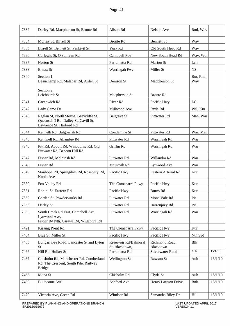
Page 41
7332 Darley Rd, Macpherson St, Bronte Rd Alison Rd
Nelson Ave Rnd, Wav
7334 Murray St, Birrell St Bronte Rd Bennett St Wav
7335 Birrell St, Bennett St, Penkivil St York Rd Old South Head Rd Wav
7336 Curlewis St, O'Sullivan Rd Campbell Pde New South Head Rd Wav, Wol
7337 Norton St Parramatta Rd Marion St Lch
7338 Ernest St Warringah Fwy Miller St NS
7340 Section 1 Beauchamp Rd, Malabar Rd, Arden St Section 2 Leichhardt St
Denison St Macpherson St
Macpherson St Bronte Rd
Bot, Rnd, Wav
7341 Greenwich Rd River Rd Pacific Hwy LC
7342 Lady Game Dr Millwood Ave Ryde Rd Wil, Kur
7343 Raglan St, North Steyne, Greycliffe St, Queenscliff Rd, Dalley St, Cavill St, Lawrence St, Harbord Rd
Belgrave St Pittwater Rd Man, War
7344 Kenneth Rd, Balgowlah Rd Condamine St Pittwater Rd War, Man
7345 Kentwell Rd, Allambie Rd Pittwater Rd Warringah Rd War
7346 Pitt Rd, Abbott Rd, Winbourne Rd, Old Pittwater Rd, Beacon Hill Rd
Griffin Rd Warringah Rd War
7347 Fisher Rd, McIntosh Rd Pittwater Rd Willandra Rd War
7348 Fisher Rd McIntosh Rd Lynwood Ave War
7349 Stanhope Rd, Springdale Rd, Rosebery Rd, Koola Ave
Pacific Hwy Eastern Arterial Rd Kur
7350 Fox Valley Rd The Comenarra Pkwy Pacific Hwy Kur
7351 Rohini St, Eastern Rd Pacific Hwy Burns Rd Kur
7352 Garden St, Powderworks Rd Pittwater Rd Mona Vale Rd Pit
7353 Darley St Pittwater Rd Barrenjoey Rd Pit
7365 South Creek Rd East, Campbell Ave, Lynwood Ave, Fisher Rd Nth, Carawa Rd, Willandra Rd
Pittwater Rd Warringah Rd War
7421 Kissing Point Rd The Comenarra Pkwy Pacific Hwy Kur
7464 Blue St, Miller St Pacific Hwy Pacific Hwy Nth Syd
7465 Bungarribee Road, Lancaster St and Lyton St
Reservoir Rd/Balmoral St, Blacktown,
Richmond Road, Blacktown
Blk
7466 Hill Rd, Holker St Parramatta Rd Silverwater Road Aub 15/1/10
7467 Chisholm Rd, Manchester Rd, Cumberland Rd, The Crescent, South Pde, Railway Bridge
Wellington St Rawson St Aub 15/1/10
7468 Mona St Chisholm Rd Clyde St Aub 15/1/10
7469 Bullecourt Ave Ashford Ave Henry Lawson Drive Bnk 15/1/10
7470 Victoria Ave, Green Rd Windsor Rd Samantha Riley Dr Hil 15/1/10
PREPARED BY PLANNING AND OPERATIONS BRANCH LAST UPDATED APRIL 2017 SF2012/015672 VERSION 11
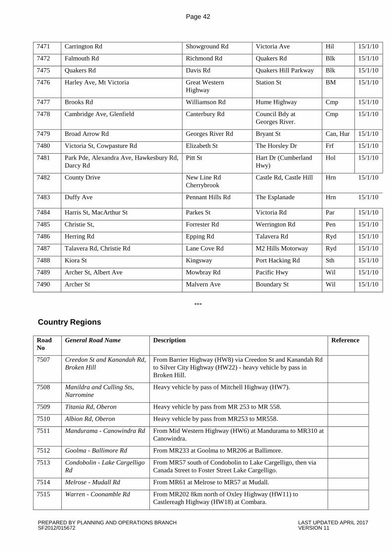
Page 42
7471 Carrington Rd Showground Rd Victoria Ave Hil 15/1/10
7472 Falmouth Rd Richmond Rd Quakers Rd Blk 15/1/10
7475 Quakers Rd Davis Rd Quakers Hill Parkway Blk 15/1/10
7476 Harley Ave, Mt Victoria Great Western Highway
Station St BM 15/1/10
7477 Brooks Rd Williamson Rd Hume Highway Cmp 15/1/10
7478 Cambridge Ave, Glenfield Canterbury Rd Council Bdy at Georges River.
Cmp 15/1/10
7479 Broad Arrow Rd Georges River Rd Bryant St Can, Hur 15/1/10
7480 Victoria St, Cowpasture Rd Elizabeth St The Horsley Dr Frf 15/1/10
7481 Park Pde, Alexandra Ave, Hawkesbury Rd, Darcy Rd
Pitt St Hart Dr (Cumberland Hwy)
Hol 15/1/10
7482 County Drive New Line Rd Cherrybrook
Castle Rd, Castle Hill Hrn 15/1/10
7483 Duffy Ave Pennant Hills Rd The Esplanade Hrn 15/1/10
7484 Harris St, MacArthur St Parkes St Victoria Rd Par 15/1/10
7485 Christie St, Forrester Rd Werrington Rd Pen 15/1/10
7486 Herring Rd Epping Rd Talavera Rd Ryd 15/1/10
7487 Talavera Rd, Christie Rd Lane Cove Rd M2 Hills Motorway Ryd 15/1/10
7488 Kiora St Kingsway Port Hacking Rd Sth 15/1/10
7489 Archer St, Albert Ave Mowbray Rd Pacific Hwy Wil 15/1/10
7490 Archer St Malvern Ave Boundary St Wil 15/1/10
***
Country Regions Road No
General Road Name Description Reference
7507 Creedon St and Kanandah Rd, Broken Hill
From Barrier Highway (HW8) via Creedon St and Kanandah Rd to Silver City Highway (HW22) - heavy vehicle by pass in Broken Hill.
7508 Manildra and Culling Sts, Narromine
Heavy vehicle by pass of Mitchell Highway (HW7).
7509 Titania Rd, Oberon Heavy vehicle by pass from MR 253 to MR 558.
7510 Albion Rd, Oberon Heavy vehicle by pass from MR253 to MR558.
7511 Mandurama - Canowindra Rd From Mid Western Highway (HW6) at Mandurama to MR310 at Canowindra.
7512 Goolma - Ballimore Rd From MR233 at Goolma to MR206 at Ballimore.
7513 Condobolin - Lake Cargelligo Rd
From MR57 south of Condobolin to Lake Cargelligo, then via Canada Street to Foster Street Lake Cargelligo.
7514 Melrose - Mudall Rd From MR61 at Melrose to MR57 at Mudall.
7515 Warren - Coonamble Rd From MR202 8km north of Oxley Highway (HW11) to Castlereagh Highway (HW18) at Combara.
PREPARED BY PLANNING AND OPERATIONS BRANCH LAST UPDATED APRIL 2017 SF2012/015672 VERSION 11
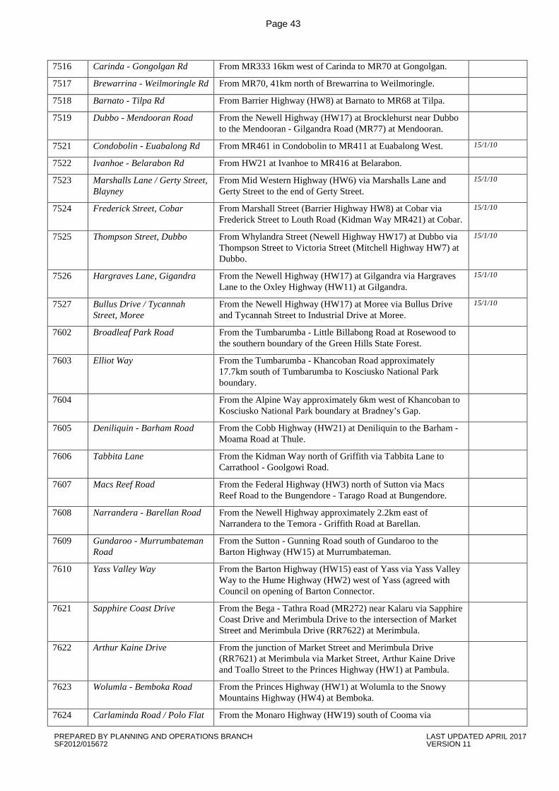
Page 43
7516 Carinda - Gongolgan Rd From MR333 16km west of Carinda to MR70 at Gongolgan.
7517 Brewarrina - Weilmoringle Rd From MR70, 41km north of Brewarrina to Weilmoringle.
7518 Barnato - Tilpa Rd From Barrier Highway (HW8) at Barnato to MR68 at Tilpa.
7519 Dubbo - Mendooran Road From the Newell Highway (HW17) at Brocklehurst near Dubbo to the Mendooran - Gilgandra Road (MR77) at Mendooran.
7521 Condobolin - Euabalong Rd From MR461 in Condobolin to MR411 at Euabalong West. 15/1/10
7522 Ivanhoe - Belarabon Rd From HW21 at Ivanhoe to MR416 at Belarabon.
7523 Marshalls Lane / Gerty Street, Blayney
From Mid Western Highway (HW6) via Marshalls Lane and Gerty Street to the end of Gerty Street.
15/1/10
7524 Frederick Street, Cobar From Marshall Street (Barrier Highway HW8) at Cobar via Frederick Street to Louth Road (Kidman Way MR421) at Cobar.
15/1/10
7525 Thompson Street, Dubbo From Whylandra Street (Newell Highway HW17) at Dubbo via Thompson Street to Victoria Street (Mitchell Highway HW7) at Dubbo.
15/1/10
7526 Hargraves Lane, Gigandra From the Newell Highway (HW17) at Gilgandra via Hargraves Lane to the Oxley Highway (HW11) at Gilgandra.
15/1/10
7527 Bullus Drive / Tycannah Street, Moree
From the Newell Highway (HW17) at Moree via Bullus Drive and Tycannah Street to Industrial Drive at Moree.
15/1/10
7602 Broadleaf Park Road From the Tumbarumba - Little Billabong Road at Rosewood to the southern boundary of the Green Hills State Forest.
7603 Elliot Way From the Tumbarumba - Khancoban Road approximately 17.7km south of Tumbarumba to Kosciusko National Park boundary.
7604 From the Alpine Way approximately 6km west of Khancoban to Kosciusko National Park boundary at Bradney’s Gap.
7605 Deniliquin - Barham Road From the Cobb Highway (HW21) at Deniliquin to the Barham - Moama Road at Thule.
7606 Tabbita Lane From the Kidman Way north of Griffith via Tabbita Lane to Carrathool - Goolgowi Road.
7607 Macs Reef Road From the Federal Highway (HW3) north of Sutton via Macs Reef Road to the Bungendore - Tarago Road at Bungendore.
7608 Narrandera - Barellan Road From the Newell Highway approximately 2.2km east of Narrandera to the Temora - Griffith Road at Barellan.
7609 Gundaroo - Murrumbateman Road
From the Sutton - Gunning Road south of Gundaroo to the Barton Highway (HW15) at Murrumbateman.
7610 Yass Valley Way From the Barton Highway (HW15) east of Yass via Yass Valley Way to the Hume Highway (HW2) west of Yass (agreed with Council on opening of Barton Connector.
7621 Sapphire Coast Drive From the Bega - Tathra Road (MR272) near Kalaru via Sapphire Coast Drive and Merimbula Drive to the intersection of Market Street and Merimbula Drive (RR7622) at Merimbula.
7622 Arthur Kaine Drive From the junction of Market Street and Merimbula Drive (RR7621) at Merimbula via Market Street, Arthur Kaine Drive and Toallo Street to the Princes Highway (HW1) at Pambula.
7623 Wolumla - Bemboka Road From the Princes Highway (HW1) at Wolumla to the Snowy Mountains Highway (HW4) at Bemboka.
7624 Carlaminda Road / Polo Flat From the Monaro Highway (HW19) south of Cooma via
PREPARED BY PLANNING AND OPERATIONS BRANCH LAST UPDATED APRIL 2017 SF2012/015672 VERSION 11
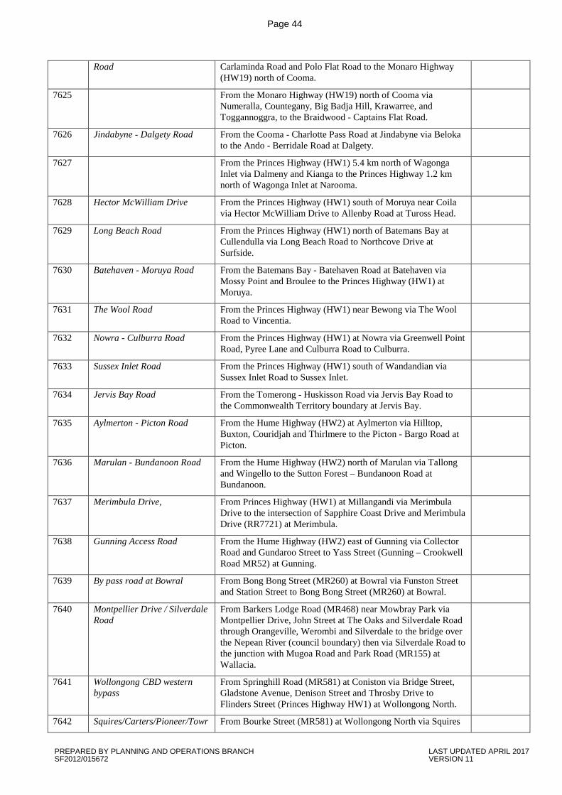
Page 44
Road Carlaminda Road and Polo Flat Road to the Monaro Highway (HW19) north of Cooma.
7625 From the Monaro Highway (HW19) north of Cooma via Numeralla, Countegany, Big Badja Hill, Krawarree, and Toggannoggra, to the Braidwood - Captains Flat Road.
7626 Jindabyne - Dalgety Road From the Cooma - Charlotte Pass Road at Jindabyne via Beloka to the Ando - Berridale Road at Dalgety.
7627 From the Princes Highway (HW1) 5.4 km north of Wagonga Inlet via Dalmeny and Kianga to the Princes Highway 1.2 km north of Wagonga Inlet at Narooma.
7628 Hector McWilliam Drive From the Princes Highway (HW1) south of Moruya near Coila via Hector McWilliam Drive to Allenby Road at Tuross Head.
7629 Long Beach Road From the Princes Highway (HW1) north of Batemans Bay at Cullendulla via Long Beach Road to Northcove Drive at Surfside.
7630 Batehaven - Moruya Road From the Batemans Bay - Batehaven Road at Batehaven via Mossy Point and Broulee to the Princes Highway (HW1) at Moruya.
7631 The Wool Road From the Princes Highway (HW1) near Bewong via The Wool Road to Vincentia.
7632 Nowra - Culburra Road From the Princes Highway (HW1) at Nowra via Greenwell Point Road, Pyree Lane and Culburra Road to Culburra.
7633 Sussex Inlet Road From the Princes Highway (HW1) south of Wandandian via Sussex Inlet Road to Sussex Inlet.
7634 Jervis Bay Road From the Tomerong - Huskisson Road via Jervis Bay Road to the Commonwealth Territory boundary at Jervis Bay.
7635 Aylmerton - Picton Road From the Hume Highway (HW2) at Aylmerton via Hilltop, Buxton, Couridjah and Thirlmere to the Picton - Bargo Road at Picton.
7636 Marulan - Bundanoon Road From the Hume Highway (HW2) north of Marulan via Tallong and Wingello to the Sutton Forest – Bundanoon Road at Bundanoon.
7637 Merimbula Drive, From Princes Highway (HW1) at Millangandi via Merimbula Drive to the intersection of Sapphire Coast Drive and Merimbula Drive (RR7721) at Merimbula.
7638 Gunning Access Road From the Hume Highway (HW2) east of Gunning via Collector Road and Gundaroo Street to Yass Street (Gunning – Crookwell Road MR52) at Gunning.
7639 By pass road at Bowral From Bong Bong Street (MR260) at Bowral via Funston Street and Station Street to Bong Bong Street (MR260) at Bowral.
7640 Montpellier Drive / Silverdale Road
From Barkers Lodge Road (MR468) near Mowbray Park via Montpellier Drive, John Street at The Oaks and Silverdale Road through Orangeville, Werombi and Silverdale to the bridge over the Nepean River (council boundary) then via Silverdale Road to the junction with Mugoa Road and Park Road (MR155) at Wallacia.
7641 Wollongong CBD western bypass
From Springhill Road (MR581) at Coniston via Bridge Street, Gladstone Avenue, Denison Street and Throsby Drive to Flinders Street (Princes Highway HW1) at Wollongong North.
7642 Squires/Carters/Pioneer/Towr From Bourke Street (MR581) at Wollongong North via Squires
PREPARED BY PLANNING AND OPERATIONS BRANCH LAST UPDATED APRIL 2017 SF2012/015672 VERSION 11

Page 45
adgi Route Way, Carters lane, Pioneer Road and Towradgi Road to Memorial Drive (Princes Highway HW1) at Towradgi.
7643 Crooked River Road From the southern abutment of the bridge over Gerroa River at Gerroa (MR571) via Crooked River Road and Bolong Road to Shoalhaven Heads Road at Coolangatta (MR293).
7705 North Star Road From the Tamworth - Yetman Road (MR63) north of Warialda via North Star Road to the Tenterfield – Boggabilla Road (MR462) south of Boggabilla.
23/4/10
7706 Glen Innes – Emmaville Road From the Gwydir Highway (HW12) at Glen Innes to the Deepwater - Emmaville Road (MR136) at Emmaville.
7707 Goonoo Goonoo Rd Tamworth
From the New England Highway (HW9) at Tamworth to the Oxley Highway (HW11) at Tamworth.
7708 Marsh St/Erskine St/Guyra Road, Armidale
From the Waterfall Way ( MR76) at Armidale to the New England Highway (HW9) at Armidale.
7709 Mullaley - Boggabri Road From the Oxley Highway (HW11) at Mullaley to the Gunnedah - Narrabri Road (MR72).
7710 Quirindi - Caroona Road From the Quirindi - Gunnedah Road (MR72) near Quirindi to the Quirindi - Coonabarabran Road (MR129) at Caroona.
7711 Rushes Creek Road From the Oxley Highway (HW11) near Somerton to the Tamworth - Yetman Road (MR63) at Manilla.
7716 Pilliga - Walgett Road From the Coonamble - Pilliga Road (MR383) at Pilliga via Come-By-Chance to the Castlereagh Highway (HW18) at Walgett.
7716 Pilliga - Walgett Rd From MR329 at Pilliga via Come-By- Chance to Castlereagh Highway (HW18) at Walgett.
7718 Nowendoc - Dungowan Road From the Gloucester - Walcha Road (RR7719) north of Nowendoc to the Nundle - Tamworth Road (MR105) at Dungowan.
7719 Gloucester - Walcha Road From the Gloucester - Taree Road (MR90) at Gloucester to the Oxley Highway (HW11) at Walcha.
7731 Pacific Highway to Illuka From the Pacific Highway (HW10) at Mororo to Charles St, Iluka.
7732 Goodwood Island Rd to Yamba Port
From the Pacific Highway (HW10) to Iluka Road (RR7731) at Woombah to the end of the bitumen near Goodwood Island Wharf.
7733 Old SH10 Sextons Hill - Qld Border
From the Pacific Highway Ramp off (HW10) end of concrete pavement at Sextons Hill to the NSW / QLD State Border (Boundary Street) Tweed Heads.
7734 Tintenbar - Wollongbar Road From the Pacific Highway (HW10) at Tintenbar to the Bruxner Highway (HW16) at Wollongbar.
7735 Ross Lane (Tintenbar) - Lennox Head
From the Pacific Highway (HW10) at Tintenbar to the Ballina – Ewingsdale Road (MR545) at Lennox Head.
7736 Scotts Head Rd From the Pacific Highway (HW10) at Macksville to the Adin Street Scotts Head.
7737 Crescent Head Rd From the Pacific Highway (HW10) at Kempsey to the East Street Roundabout, Crescent Head.
7738 Wooli Rd From the Pacific Highway (HW10) at Glenugie to Main Street, Wooli.
PREPARED BY PLANNING AND OPERATIONS BRANCH LAST UPDATED APRIL 2017 SF2012/015672 VERSION 11
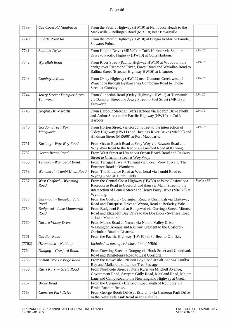
Page 46
7739 Old Coast Rd Nambucca From the Pacific Highway (HW10) at Nambucca Heads to the Macksville – Bellingen Road (MR118) near Bowraville.
7740 Stuarts Point Rd From the Pacific Highway (HW10) at Eungai to Marine Parade, Stewarts Point.
7741 Stadium Drive From Hogbin Drive (MR540) at Coffs Harbour via Stadium Drive to Pacific Highway (HW10) at Coffs Harbour.
23/4/10
7742 Wyrallah Road From River Street (Pacific Highway HW10) at Woodburn via bridge over Richmond River, Forest Road and Wyrallah Road to Ballina Street (Bruxner Highway HW16) at Lismore.
23/4/10
7743 Comboyne Road From Oxley Highway (HW11) near Gannons Creek west of Wauchope through Byabarra via Comboyne Road to Thone Street at Comboyne.
23/4/10
7744 Jewry Street / Dampier Street, Tamworth
From Gunnedah Road (Oxley Highway - HW11) at Tamworth via Dampier Street and Jewry Street to Peel Street (MR63) at Tamworth.
23/4/10
7745 Hogbin Drive North From Harbour Street at Coffs Harbour via Hogbin Drive North and Arthur Street to the Pacific Highway (HW10) at Coffs Harbour.
23/4/10
7746 Gordon Street, Port Macquarie
From Horton Street, via Gordon Street to the intersection of Oxley Highway (HW11) and Hastings River Drive (MR600) and Hindman Street (MR600) at Port Macquarie.
23/4/10
7751 Kariong - Woy Woy Road From Ocean Beach Road at Woy Woy via Rawson Road and Woy Woy Road to the Kariong – Gosford Road at Kariong.
7752 Ocean Beach Road From West Street at Umina via Ocean Beach Road and Railway Street to Charlton Street at Woy Woy.
7755 Terrigal - Wamberal Road From Terrigal Drive at Terrigal via Ocean View Drive to The Entrance Road at Wamberal.
7756 Wamberal - Tumbi Umbi Road From The Entrance Road at Wamberal via Tumbi Road to Wyong Road at Tumbi Umbi.
7757 West Gosford – Wyoming Road
From the Central Coast Highway (HW30) at West Gosford via Racecourse Road to Gosford, and then via Mann Street to the intersection of Pemell Street and Henry Parry Drive (MR673) at Wyoming.
Replace RR
7758 Ourimbah - Berkeley Vale Road
From the Gosford - Ourimbah Road at Ourimbah via Chittaway Road and Enterprise Drive to Wyong Road at Berkeley Vale.
7759 Budgewoi - Lake Munmorah Road
From Budgewoi Road at Budgewoi via Ourringo Street, Mimosa Road and Elizabeth Bay Drive to the Doyalson - Swansea Road at Lake Munmorah.
7760 Narara Valley Drive From Manns Road at Narara via Narara Valley Drive, Washington Avenue and Railway Crescent to the Gosford - Ourimbah Road at Lisarow.
7761 Old Bar Road From the Pacific Highway (HW10) at Purfleet to Old Bar.
(7762) (Krambach – Nabiac) Included as part of redeclaration of MR90
7764 Dungog – Gresford Road. From Dowling Street at Dungog via Hook Street and Underbank Road and Bingleburra Road to East Gresford.
7765 Lemon Tree Passage Road From the Newcastle - Nelson Bay Road at Salt Ash via Tanilba Bay and Mallabula to Lemon Tree Passage.
7766 Kurri Kurri – Greta Road From Northcote Street at Kurri Kurri via Mitchell Avenue, Government Road, Sawyers Gully Road, Maitland Road, Majors Lane and Camp Road to the New England Highway at Greta.
7767 Broke Road From the Cessnock - Branxton Road south of Rothbury via Broke Road to Broke.
7768 Cameron Park Drive From George Booth Drive at Estelville via Cameron Park Drive to the Newcastle Link Road near Estelville.
PREPARED BY PLANNING AND OPERATIONS BRANCH LAST UPDATED APRIL 2017 SF2012/015672 VERSION 11
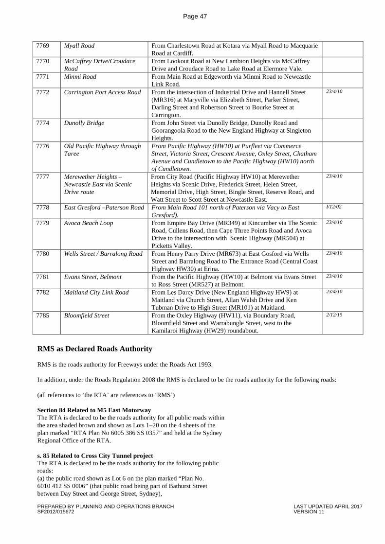
Page 47
7769 Myall Road From Charlestown Road at Kotara via Myall Road to Macquarie Road at Cardiff.
7770 McCaffrey Drive/Croudace Road
From Lookout Road at New Lambton Heights via McCaffrey Drive and Croudace Road to Lake Road at Elermore Vale.
7771 Minmi Road From Main Road at Edgeworth via Minmi Road to Newcastle Link Road.
7772 Carrington Port Access Road From the intersection of Industrial Drive and Hannell Street (MR316) at Maryville via Elizabeth Street, Parker Street, Darling Street and Robertson Street to Bourke Street at Carrington.
23/4/10
7774 Dunolly Bridge From John Street via Dunolly Bridge, Dunolly Road and Goorangoola Road to the New England Highway at Singleton Heights.
7776 Old Pacific Highway through Taree
From Pacific Highway (HW10) at Purfleet via Commerce Street, Victoria Street, Crescent Avenue, Oxley Street, Chatham Avenue and Cundletown to the Pacific Highway (HW10) north of Cundletown.
7777 Merewether Heights – Newcastle East via Scenic Drive route
From City Road (Pacific Highway HW10) at Merewether Heights via Scenic Drive, Frederick Street, Helen Street, Memorial Drive, High Street, Bingle Street, Reserve Road, and Watt Street to Scott Street at Newcastle East.
23/4/10
7778 East Gresford –Paterson Road From Main Road 101 north of Paterson via Vacy to East Gresford).
I/12/02
7779 Avoca Beach Loop From Empire Bay Drive (MR349) at Kincumber via The Scenic Road, Cullens Road, then Cape Three Points Road and Avoca Drive to the intersection with Scenic Highway (MR504) at Picketts Valley.
23/4/10
7780 Wells Street / Barralong Road From Henry Parry Drive (MR673) at East Gosford via Wells Street and Barralong Road to The Entrance Road (Central Coast Highway HW30) at Erina.
23/4/10
7781 Evans Street, Belmont From the Pacific Highway (HW10) at Belmont via Evans Street to Ross Street (MR527) at Belmont.
23/4/10
7782 Maitland City Link Road From Les Darcy Drive (New England Highway HW9) at Maitland via Church Street, Allan Walsh Drive and Ken Tubman Drive to High Street (MR101) at Maitland.
23/4/10
7785 Bloomfield Street From the Oxley Highway (HW11), via Boundary Road, Bloomfield Street and Warrabungle Street, west to the Kamilaroi Highway (HW29) roundabout.
2/12/15
RMS as Declared Roads Authority RMS is the roads authority for Freeways under the Roads Act 1993. In addition, under the Roads Regulation 2008 the RMS is declared to be the roads authority for the following roads: (all references to ‘the RTA’ are references to ‘RMS’) Section 84 Related to M5 East Motorway The RTA is declared to be the roads authority for all public roads within the area shaded brown and shown as Lots 1–20 on the 4 sheets of the plan marked “RTA Plan No 6005 386 SS 0357” and held at the Sydney Regional Office of the RTA. s. 85 Related to Cross City Tunnel project The RTA is declared to be the roads authority for the following public roads: (a) the public road shown as Lot 6 on the plan marked “Plan No. 6010 412 SS 0006” (that public road being part of Bathurst Street between Day Street and George Street, Sydney),
PREPARED BY PLANNING AND OPERATIONS BRANCH LAST UPDATED APRIL 2017 SF2012/015672 VERSION 11
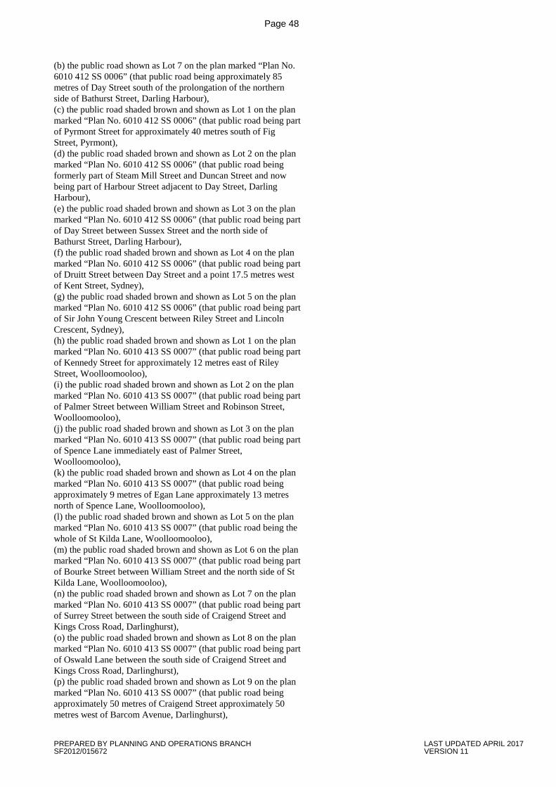
Page 48
(b) the public road shown as Lot 7 on the plan marked “Plan No. 6010 412 SS 0006” (that public road being approximately 85 metres of Day Street south of the prolongation of the northern side of Bathurst Street, Darling Harbour), (c) the public road shaded brown and shown as Lot 1 on the plan marked “Plan No. 6010 412 SS 0006” (that public road being part of Pyrmont Street for approximately 40 metres south of Fig Street, Pyrmont), (d) the public road shaded brown and shown as Lot 2 on the plan marked “Plan No. 6010 412 SS 0006” (that public road being formerly part of Steam Mill Street and Duncan Street and now being part of Harbour Street adjacent to Day Street, Darling Harbour), (e) the public road shaded brown and shown as Lot 3 on the plan marked “Plan No. 6010 412 SS 0006” (that public road being part of Day Street between Sussex Street and the north side of Bathurst Street, Darling Harbour), (f) the public road shaded brown and shown as Lot 4 on the plan marked “Plan No. 6010 412 SS 0006” (that public road being part of Druitt Street between Day Street and a point 17.5 metres west of Kent Street, Sydney), (g) the public road shaded brown and shown as Lot 5 on the plan marked “Plan No. 6010 412 SS 0006” (that public road being part of Sir John Young Crescent between Riley Street and Lincoln Crescent, Sydney), (h) the public road shaded brown and shown as Lot 1 on the plan marked “Plan No. 6010 413 SS 0007” (that public road being part of Kennedy Street for approximately 12 metres east of Riley Street, Woolloomooloo), (i) the public road shaded brown and shown as Lot 2 on the plan marked “Plan No. 6010 413 SS 0007” (that public road being part of Palmer Street between William Street and Robinson Street, Woolloomooloo), (j) the public road shaded brown and shown as Lot 3 on the plan marked “Plan No. 6010 413 SS 0007” (that public road being part of Spence Lane immediately east of Palmer Street, Woolloomooloo), (k) the public road shaded brown and shown as Lot 4 on the plan marked “Plan No. 6010 413 SS 0007” (that public road being approximately 9 metres of Egan Lane approximately 13 metres north of Spence Lane, Woolloomooloo), (l) the public road shaded brown and shown as Lot 5 on the plan marked “Plan No. 6010 413 SS 0007” (that public road being the whole of St Kilda Lane, Woolloomooloo), (m) the public road shaded brown and shown as Lot 6 on the plan marked “Plan No. 6010 413 SS 0007” (that public road being part of Bourke Street between William Street and the north side of St Kilda Lane, Woolloomooloo), (n) the public road shaded brown and shown as Lot 7 on the plan marked “Plan No. 6010 413 SS 0007” (that public road being part of Surrey Street between the south side of Craigend Street and Kings Cross Road, Darlinghurst), (o) the public road shaded brown and shown as Lot 8 on the plan marked “Plan No. 6010 413 SS 0007” (that public road being part of Oswald Lane between the south side of Craigend Street and Kings Cross Road, Darlinghurst), (p) the public road shaded brown and shown as Lot 9 on the plan marked “Plan No. 6010 413 SS 0007” (that public road being approximately 50 metres of Craigend Street approximately 50 metres west of Barcom Avenue, Darlinghurst),
PREPARED BY PLANNING AND OPERATIONS BRANCH LAST UPDATED APRIL 2017 SF2012/015672 VERSION 11
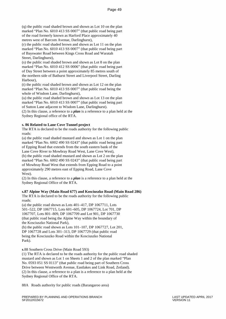
Page 49
(q) the public road shaded brown and shown as Lot 10 on the plan marked “Plan No. 6010 413 SS 0007” (that public road being part of the road formerly known as Harford Place approximately 40 metres west of Barcom Avenue, Darlinghurst), (r) the public road shaded brown and shown as Lot 11 on the plan marked “Plan No. 6010 413 SS 0007” (that public road being part of Bayswater Road between Kings Cross Road and Waratah Street, Darlinghurst), (s) the public road shaded brown and shown as Lot 8 on the plan marked “Plan No. 6010 412 SS 0006” (that public road being part of Day Street between a point approximately 85 metres south of the northern side of Bathurst Street and Liverpool Street, Darling Harbour), (t) the public road shaded brown and shown as Lot 12 on the plan marked “Plan No. 6010 413 SS 0007” (that public road being the whole of Wisdom Lane, Darlinghurst), (u) the public road shaded brown and shown as Lot 13 on the plan marked “Plan No. 6010 413 SS 0007” (that public road being part of Sutton Lane adjacent to Wisdom Lane, Darlinghurst). (2) In this clause, a reference to a plan is a reference to a plan held at the Sydney Regional office of the RTA. s. 86 Related to Lane Cove Tunnel project The RTA is declared to be the roads authority for the following public roads: (a) the public road shaded mustard and shown as Lot 1 on the plan marked “Plan No. 6002 490 SS 0243” (that public road being part of Epping Road that extends from the south eastern bank of the Lane Cove River to Mowbray Road West, Lane Cove West), (b) the public road shaded mustard and shown as Lot 2 on the plan marked “Plan No. 6002 490 SS 0243” (that public road being part of Mowbray Road West that extends from Epping Road to a point approximately 290 metres east of Epping Road, Lane Cove West). (2) In this clause, a reference to a plan is a reference to a plan held at the Sydney Regional Office of the RTA. s.87 Alpine Way (Main Road 677) and Kosciuszko Road (Main Road 286) The RTA is declared to be the roads authority for the following public roads: (a) the public road shown as Lots 401–417, DP 1067711, Lots 501–522, DP 1067715, Lots 601–605, DP 1067724, Lot 701, DP 1067707, Lots 801–809, DP 1067709 and Lot 901, DP 1067730 (that public road being the Alpine Way within the boundary of the Kosciuszko National Park), (b) the public road shown as Lots 101–107, DP 1067727, Lot 201, DP 1067728 and Lots 301–313, DP 1067729 (that public road being the Kosciuszko Road within the Kosciuszko National Park). s.88 Southern Cross Drive (Main Road 593) (1) The RTA is declared to be the roads authority for the public road shaded mustard and shown as Lot 1 on Sheets 1 and 2 of the plan marked “Plan No. 0593 051 SS 0113” (that public road being part of Southern Cross Drive between Wentworth Avenue, Eastlakes and Link Road, Zetland). (2) In this clause, a reference to a plan is a reference to a plan held at the Sydney Regional Office of the RTA. 88A Roads authority for public roads (Barangaroo area)
PREPARED BY PLANNING AND OPERATIONS BRANCH LAST UPDATED APRIL 2017 SF2012/015672 VERSION 11
Page 50
(1) The Barangaroo Delivery Authority is declared to be the roads authority for the public roads shaded red on the plan marked “Roads Authority Plan—Barangaroo” and dated 6 December 2010, being the following: (a) that part of Hickson Road from the northern side of the intersection with Napoleon Street and Sussex Street in the south to the southern side of the Windmill Street overpass in the north, (b) that part of Napoleon Street from the intersection with Hickson Road and Sussex Street to the western side of the intersection with Kent Street, (c) that part of Sussex Street from and including the intersection with Napoleon Street and Hickson Road in the north to (and including) the intersection with Shelley Street in the south. (2) In this clause, a reference to a plan is a reference to a plan held at the Sydney Regional Office of the RTA. (3) This clause ceases to have effect at the beginning of 31 January 2013. s. 89 Bethanga Bridge The RTA is declared to be the roads authority for the public road shown as Lots 2 and 3 in DP 1066273 (that public road being part of Bethanga Bridge, Lake Hume Village). s. 89A Related to M2 Motorway upgrade (2/2011) (1) The RTA is declared to be the roads authority for the following public roads: (a) the public road shaded brown and shown as Lot 1 on the plan marked “Plan No. 6002 031 SS 4013” (that road being part of Barclay Road north of the bridge over the M2 Motorway at North Rocks for a distance of approximately 60 metres along the road centreline from the motorway boundary), (b) the public road shaded brown and shown as Lots 1 and 2 on Sheet 1 of the plan marked “Plan No. 6002 201 SS 4014” (that road being part of Murray Farm Road at and near its intersection with Midson Road, Beecroft), (c) the public road shaded brown and shown as Lot 3 on Sheet 2 of the plan marked “Plan No. 6002 201 SS 4014” (that road being part of Somerset Street from a point approximately 67 metres east of Gloucester Road to a point approximately 115 metres west of Gloucester Road, Epping), (d) the public road shaded brown and shown as Lot 1 on Sheet 1 of the plan marked “Plan No. 6002 387 SS 4015” (that road being part of Busaco Road north of the underpass across the M2 Motorway at Marsfield), (e) the public road shaded brown and shown as Lot 2 on Sheet 1 of the plan marked “Plan No. 6002 387 SS 4015” (that road being part of Talavera Road at its intersection with Busaco Road, Marsfield), (f) the public road shaded brown and shown as Lot 3 on Sheet 2 of the plan marked “Plan No. 6002 387 SS 4015” (that road being part of Christie Road north of the bridge over the M2 Motorway at Macquarie Park for a distance of approximately 30 metres from the motorway boundary), (g) the public road shaded brown and shown as Lot 4 on Sheet 2 of the plan marked “Plan No. 6002 387 SS 4015” (that road being part of Christie Road south of the bridge over the M2 Motorway to Talavera Road, Macquarie Park), (h) the public road shaded brown and shown as Lot 5 on Sheet 2 of the plan marked “Plan No. 6002 387 SS 4015” (that road being part of Talavera Road from a point approximately 160 metres west of Christie Road to Alma Road, Macquarie Park), (i) the public road shaded brown and shown as Lot 6 on Sheet 2 of the plan marked “Plan No. 6002 387 SS 4015” (that road being part of Herring Road at its intersection with Talavera Road, Macquarie Park), (j) the public road shaded brown and shown as Lot 7 on Sheet 3 of the plan marked “Plan No. 6002 387 SS 4015” (that road being part of Khartoum Road south of the bridge over the M2 Motorway at Macquarie Park for a distance of approximately 16 metres from the motorway boundary). (2) In this clause, a reference to a plan is a reference to a plan held at the Sydney Regional Office of the RTA. (3) This clause ceases to have effect at the beginning of 1 April 2013. END
PREPARED BY PLANNING AND OPERATIONS BRANCH LAST UPDATED APRIL 2017 SF2012/015672 VERSION 11