schedule c class ea environmental study report
TRANSCRIPT

COUNTY ROAD 21 IMPROVEMENTS County Road 27 to County Road 39
Schedule C Class EA Environmental Study Report
prepared by: prepared for
C.C. Tatham & Associates Ltd. 41 King Street, Unit 4 Barrie, ON L4N 6B5 Tel: (705) 733-9037 Fax: (705) 733-1520 [email protected]
Simcoe County
February 13, 2015
CCTA File 409390

Table of Contents
Executive Summary i
1 Introduction 1
1.1 Class Environmental Assessment Process 1
1.2 Objectives of the Environmental Study Report 3
1.3 Format of the Environmental Study Report 3
2 Need & Justification 5
2.1 Study Area 5
2.2 Existing Conditions 5
2.3 Future Conditions 12
2.4 Problem Statement 13
3 Consultation - Study Commencement 14
3.1 Notification 14
3.2 Public Comments 14
3.3 Agency Comments 15
4 Alternative Solutions 17
4.1 Alternative A - Do Nothing 17
4.2 Alternative B - Reduce Travel Demands 17
4.3 Alternative C - Alternative Travel Route 17
4.4 Alternative D - Reconstruct County Road 21 & Intersection Improvements 17
4.5 Alternative E - Widen County Road 21 to 4 lanes to the North 18

4.6 Alternative F - Widen County Road 21 to 4 lanes to the South 18
4.7 Alternative G - Widen County Road 21 to 4 lanes Equally on Both Sides 18
5 Environment Inventories - Alternative Solutions 19
5.1 Physical Environment 19
5.2 Natural Environment 20
5.3 Social Environment 21
5.4 Cultural/Heritage Environment 22
5.5 Economic Environment 22
6 Evaluation of Alternative Solutions 24
6.1 Initial Screening 24
6.2 Evaluation Criteria 24
6.3 Environmental Impacts 25
6.4 Recommended Solution 29
7 Stakeholder Consultation - PIC 1 30
7.1 Purpose 30
7.2 Notification 30
7.3 Public Information Centre 31
7.4 Public Comments 31
7.5 Agency Comment 35
8 Preferred Solution 36
8.1 Preferred Solution 36
8.2 Confirmation of EA Schedule 36
9 Alternative Design Concepts for the Preferred Solution 37
9.1 Design Alternative G1 - 40 m Right-of-Way, Rural Cross-Section 37
9.2 Design Alternative G2 - 36 m Right-of-Way, Rural Cross-Section 37
9.3 Design Alternative G3 - Maintain Existing Right-of-Way, Urban Cross-Section 37
9.4 Stormwater Management Considerations 37
10 Environment Inventories - Alternative Design Concepts 39
10.1 Physical Environment 39
10.2 Natural Environment 40
10.3 Social Environment 42
10.4 Cultural/Heritage Environment 43
10.5 Economic Environment 43
11 Evaluation of Alternative Design Concepts 44
11.1 Simcoe County Design Standard - Primary Arterial 45
11.2 Impacts of Design Alternatives 45
12 Stakeholder Consultation - PIC 2 54
12.1 Purpose 54
12.2 Notification 54
12.3 Public Information Centre 2 55
12.4 Public Comments 55
12.5 Agency Comments 55
13 Preferred Design 58

13.1 Preferred Design 58
13.2 Impact Mitigation 59
13.3 Monitoring 61
14 Completion of Municipal Class EA Process 63
14.1 Submission to Simcoe County 63
14.2 Stakeholder Consultation - Study Completion 63
14.3 30-Day Review Period 63
14.4 Implementation 64
Appendices
Appendix A: Traffic Counts
Appendix B: Notice of Study Commencement
Appendix C: Natural Environment Inventory Report
Appendix D: Archaeological Assessment
Appendix E: Noise Study
Appendix F: Public Information Centre 1
Appendix G: Stormwater Management Design Brief
Appendix H: Natural Environment Impact Assessment
Appendix I: Public Information Centre 2
Appendix J: Preliminary Design Drawings
Appendix K: Notice of Study Completion

List of Tables
Table 1: County Road 21 Intersections 7
Table 2: County Road 21 Driveways 8
Table 3: County Road 21 Roadside Protection 9
Table 4: 2013 Traffic Volumes on County Road 21 10
Table 5: Water Crossings 11
Table 6: Future Traffic Volumes on County Road 21 12
Table 7: Public Comments - Study Commencement 15
Table 8: Evaluation of Alternative Solutions - Zone 1 26
Table 9: Evaluation of Alternative Solutions - Zone 2 27
Table 10: Evaluation of Alternative Solutions – Zone 3 27
Table 11: Evaluation of Alternative Solutions - Zone 4 28
Table 12: Evaluation of Alternative Solutions - Zone 5 28
Table 13: Public Comments & Preferred Alternative 32
Table 14: Evaluation of Alternative Design Concepts - Section 1 46
Table 15: Evaluation of Alternative Design Concepts - Section 2 47
Table 16: Evaluation of Alternative Design Concepts - Section 4 48
Table 17: Evaluation of Alternative Design Concepts - Section 5 49
Table 18: Evaluation of Alternative Design Concepts - Section 7 50
Table 19: Evaluation of Alternative Design Concepts - Section 9 51
Table 20: Evaluation of Alternative Design Concepts - Section 10 52
Table 21: Evaluation of Alternative Design Concepts - Section 11 53
Table 22: Summary of Public Comments & Responses - PIC 2 56

Table 23: Preferred Design 58
Table 24: Summary of Mitigating Measures 60
List of Figures
Figure 1: Municipal Class EA Process 65
Figure 2: Study Area 66
Figure 3: Existing Conditions 67
Figure 4: Simcoe County Transportation System 68
Figure 5: Aerial Photos & Road Section Details 69
Figure 6: Water Crossings 73
Figure 7: Simcoe County - Evaluated Wetlands 75
Figure 8: Simcoe County - Land-use Designations 76
Figure 9: Preferred Solution - Alternative Design Concepts 77
Figure 10: Stormwater Management Features - 50m ROW 78
Figure 11: Preferred Solution by Road Section 79
County Road 21 Improvements Schedule C Class EA Environmental Study Report
Page i February 13, 2015
Executive Summary
Study Purpose
Simcoe County initiated a Municipal Class Environmental Assessment to identify the most appropriate road improvement strategy for County Road 21 from County Road 27 to County Road 39/20th Sideroad, a distance of approximately 12 kilometres. Various improvements have been considered to address the existing and future needs of the road. This study was completed in accordance with the planning and design process for a ‘Schedule C’ project as outlined in the Municipal Engineers Association Municipal Class Environmental Assessment document (2000, revised in 2007 and 2011).
Class EA Phases 1 & 2
Phase 1 and 2 of the Class EA process includes defining the problem, development of alternative solutions and formulation of measures to mitigate identified impacts. In consideration of the existing conditions, the Problem Statement, which sets the framework for the study, is as follows:
That existing traffic and infrastructure deficiencies along the subject length of County Road 21 be corrected in an environmentally friendly manner, in consideration of future traffic needs, current County standards and the safe and efficient traffic operations for all road users.
Alternative solutions to address the Problem Statement included the following:
Alternative A do nothing (maintain existing conditions)
Alternative B reduce travel demands on County Road 21
Alternative C establish/designate alternative routes to County Road 21
Alternative D reconstruct County Road 21 (maintain existing 2-lane cross-section) with intersection improvements
Alternative E widen County Road 21 to a 4-lane cross-section and acquire necessary property along the north side
Alternative F widen County Road 21 to a 4-lane cross-section and acquire necessary property along the south side
Alternative G widen County Road 21 to a 4-lane cross-section and acquire necessary property equally on the north and south sides (ie. maintain existing centreline)
At the conclusion of Phases 1 and 2 of the Municipal Class EA process (which included a presentation of the noted alternatives at Public Information Centre 1), the alternative solution to widen County Road 21 to a 4-lane cross-section while maintaining the existing centreline was identified as the preferred solution (Alternative G).

County Road 21 Improvements Schedule C Class EA Environmental Study Report
Page ii February 13, 2015
Class EA Phase 3
Following the identification of the preferred solution, a number of alternative design concepts were developed to implement the solution, based on Simcoe County design standards for a primary arterial road. To mitigate the impacts of the road widening or to address other constraints, modifications to the County standards were considered. These modifications primarily involve the right-of-way width and/or the cross-section design (ie. rural vs urban). Regardless of the modifications, all of the design concepts considered the same 4-lane platform. The following alternative design concepts for the preferred solution were considered:
Alternative G1 4-lane rural cross-section within a 40 metre ROW (or 45/50 metre ROW where SWM requirements dictate)
Alternative G2 4-lane rural cross-section within a 36 metre ROW
Alternative G3 4-lane urban cross-section within the existing ROW
The design alternatives were assessed in terms of the impacts to the various environments as well as the potential to mitigate such impacts. The primary impacts identified relate to property requirements and impacts to the adjacent land uses. Impacts to the natural environment associated with the widening of County Road 21 can be appropriately mitigated through the design and implementation process.
The results of the evaluation process revealed that a combination of the design alternatives represent the best approach to implementing the preferred solution in that the environments are not consistent throughout the entire section of County Road 21. Thus the impacts in one area may not exist in other areas. The subject length of County Road 21 was divided into 11 sections based on the existing roadside environs. Each design alternative was assessed to determine the most appropriate solution for each respective road segment. The recommended design alternative for each segment of County Road 21, as per the assessment, was presented to the public at Public Information Centre 2. The road sections considered are detailed below:
Section 1 80 m east of County Road 27 to 620 m east of County Road 27
Section 2 620 m east of County Road 27 to 300 m west of 5th Sideroad (County Jurisdiction Limit)
Section 3 300 m west of 5th Sideroad (County Jurisdiction Limit) to east of Highway 400
Section 4 Industrial Park road to 100 m east of Innisfil Heights Crescent
Section 5 100 m east of Innisfil Heights Crescent to 120 m east of Innisbrook Street
Section 6 120 m east of Innisbrook Street to 300 m east of County Road 54

County Road 21 Improvements Schedule C Class EA Environmental Study Report
Page iii February 13, 2015
Section 7 300 m east of County Road 54 to 300 m west of County Road 4
Section 8 300 m west of County Road 4 to 650 m east of County Road 4
Section 9 650 m east of County Road 4 to 930 m east of County Road 4
Section 10 930 m east of County Road 4 to 1270 m east of County Road 4
Section 11 1270 m east of County Road 4 to 380 m west of County Road 39
The following is a summary of the recommended preferred design alternatives for each of the noted sections of County Road 21:
Road Section
Length Preferred Design
Section 1 540 m Alternative G3 - maintain existing ROW, implement urban cross section
Section 2 2,015 m Alternative G1 - establish 40 metre ROW (50 metre ROW where SWM features dictate), implement rural cross section
Section 3 1,560 m Intersection improvements - separate Class EA study
Section 4 425 m Alternative G3 - maintain existing ROW, implement urban cross section
Section 5 800 m Alternative G3 - maintain existing ROW, implement urban cross section
Section 6 950 m Intersection improvements - separate Class EA study
Section 7 2,430 m Alternative G1 - establish 40 metre ROW (45/50 metre ROW where SWM features dictate), implement rural cross section
Section 8 980 m Intersection improvements - separate Class EA study
Section 9 280 m Alternative G1 - establish 40 metre ROW, implement rural cross section
Section 10 320 m Alternative G3 - maintain ROW to north and establish 30m ROW by widening ROW to south (approximately 5m), implement urban cross section
Section 11 1,330 m Alternative G1 - establish 40 metre ROW (45/50 metre ROW where SWM features dictate), implement rural cross section

County Road 21 Improvements Schedule C Class EA Environmental Study Report
Page iv February 13, 2015
The preferred design alternatives will be presented to Simcoe County for endorsement, following which the Environmental Study Report (ESR) will be placed on public record for the mandatory 30 calendar day public review period. A Notice of Study Completion will be posted on the County’s website and in the local newspapers. Members of the public, stakeholders, special interest groups and external agencies who have expressed an interest and a desire to stay involved will also be provided with a copy of the Notice.
If concerns are raised during the review period which cannot be resolved in discussion with Simcoe County, a person may request that the Minister of the Environment make an order for the project to comply with Part II of the Environmental Assessment Act (referred to as a Part II Order), which addresses individual environmental assessments. Requests must be received by the Minister at the address below within thirty (30) days of publication of the notice of Study Completion. A copy of the request must also be sent to the County. If no request is received, the project may proceed to Phase 5 Implementation (design and construction).
The Honourable Glen Murray Minister of the Environment & Climate Change
77 Wellesley Street West, 11th Floor, Ferguson Block Toronto, Ontario M7A 2T5
County Road 21 Improvements Schedule C Class EA Environmental Study Report
Page 1 February 13, 2015
1 Introduction
The County of Simcoe initiated a Class Environmental Assessment (Class EA) to examine improvements to Simcoe Road 21, between County Road 27 to County Road 39, in the Town of Innisfil. C.C. Tatham and Associates Ltd. were retained to complete the study on behalf of the County, in accordance with the Municipal Class Environmental Assessment guidelines1. It is noted that separate Class EA studies have been completed for intersection improvements at 5th Sideroad, County Road 54/10th Sideroad and County Road 4/Yonge Street and thus these intersections have not been included in this study (the limits of exclusion correspond to the limits of the corresponding studies).
1.1 Class Environmental Assessment Process
The Class Environmental Assessment process is defined in the Municipal Class Environmental Assessment document. Applying to all municipal road improvement projects, a number of study categories or schedules have been established recognizing the range of environmental impacts. These are briefly described below whereas the process corresponding to each is illustrated in Figure 1.
1.1.1 Class EA Schedules
Schedule A Schedule A projects generally include normal or emergency operational and maintenance activities. As the environmental effects of these activities are usually minimal, these projects are pre-approved and may proceed directly to implementation without the need to complete the design and planning process. No reports or study documents need to be prepared.
Schedule A+ Schedule A+ projects are typically limited in size and scope, and thus have minimal associated environmental impacts. While these projects are also pre-approved, they require notification to the public prior to implementation. No reports or study documents need to be prepared outside of the notification.
Schedule B Schedule B projects generally include improvements and minor expansions to existing facilities. As there is the potential for some adverse environmental impacts, the municipality is required to conduct a screening process whereby members of the public and review agencies are informed of the project and given the opportunity to provide comment. Documentation of the planning and design process is required under a Schedule B study. As these studies are generally straightforward and do not require detailed technical investigations to arrive at the preferred solution, a formal report is not required.
1 Municipal Class Environmental Assessment. Municipal Engineers Association, October 2000 as amended in 2007.

County Road 21 Improvements Schedule C Class EA Environmental Study Report
Page 2 February 13, 2015
Rather, a Project File shall be prepared to demonstrate that the appropriate steps have been followed. The Project File is to be submitted for review by the public and review agencies.
Schedule C Schedule C projects generally include the construction of new facilities and major expansions to existing facilities. As they have the potential for environmental impacts, they must proceed under the full planning and documentation procedures specified by the Municipal Class EA document. Schedule C projects require an Environmental Study Report (ESR) to be prepared and appropriately filed for review by the public and review agencies.
1.1.2 Class EA Terminology
Prior to determining the appropriate Class EA schedule, an understanding of the defining terminology is required as noted below:
Road Capacity Means capacity defined in terms of the number of travelled lanes and does not differentiate between various lane widths to accommodate differing traffic volumes.
New Road Means the construction of an improved surface for vehicular traffic on a new right-of-way where the right-of-way is entirely separate from any previous right-of-way. Also refers to the construction of a road on a road allowance whereby no road surface previously existed
Same Purpose, Use, Capacity and Location Refers to the replacement or upgrading of a structure or facility or its performance, where the objective and application remain unchanged, and the volume, size and capability do not exceed the minimum municipal standard, or the existing rated capacity, and there is no substantial change of location. Works carried out within an existing road allowance such that no land acquisition is required are considered to be in the same location. Conversely, it is thus inferred that should improvements extend beyond the existing road allowance and additional property is required, the location is considered to have changed.
1.1.3 Selected Schedule
The reconstruction of County Road 21 would be classified as a Schedule A+ project provided there are no changes to the road’s purpose, use, capacity or location (which would be case if the road was simply reconstructed to its existing width). However, should the road require widening to address traffic operations, the road capacity will be increased and hence a Schedule B or C undertaking would apply, based on the overall cost of work.
County Road 21 Improvements Schedule C Class EA Environmental Study Report
Page 3 February 13, 2015
A Schedule B process is applicable when the construction value is less than $2.4 million, whereas a Schedule C process applies when the value exceeds $2.4 million. Given the length of road and extent of widening anticipated, the cost will exceed $2.4 million and hence the study was planned in accordance with the Schedule C requirements. The proponent of a Schedule ‘C’ project is required to undertake a process involving mandatory contact with the directly affected public and with relevant government agencies to ensure that they are aware of the project and that their concerns are addressed. Public consultation is to be conducted regarding the alternative solutions and the alternative design concepts (Phases 2 and 3 of the Class EA process respectively).
1.2 Objectives of the Environmental Study Report
The overall objective of this report is to document the planning process undertaken during the Class EA process related to the development and evaluation of alternative solutions and designs. Specifically the objectives of this report are as follows:
to prepare a detailed description of the problem;
to establish alternatives to address the problem;
to prepare a detailed inventory of the affected/applicable environments (physical, natural, social, economic, cultural, etc.);
to screen the impact of the alternatives on the environment;
to establish mitigative measures to minimize potential environmental effects;
to establish alternative designs to address the problem in accordance with the preferred solution;
to evaluate the alternative designs and select a preferred design; and
to outline the remaining steps involved in the planning and design for the widening of County Road 21 to complete the Municipal Class Environmental Assessment process.
1.3 Format of the Environmental Study Report
The Environmental Study Report has been prepared in accordance with the chronological order of the Class EA process and is structured as follows:
Chapter 2 presents the need and justification of the study and the preparation of a problem statement to guide the Municipal Class EA process;
Chapter 3 addresses the first point of public consultation - Notice of Study Commencement;
Chapter 4 details the alternative solutions developed to address the problem statement;

County Road 21 Improvements Schedule C Class EA Environmental Study Report
Page 4 February 13, 2015
Chapter 5 identifies the affected environments and provides an inventory of such to be considered in the subsequent evaluation;
Chapter 6 details the evaluation of the alternative solutions in context of the manner to which they satisfy the problem statement and potential impacts to the environments;
Chapter 7 addresses the second point of public consultation - Public Information Centre 1;
Chapter 8 identifies the preferred solution, considering the initial evaluation and comments received from Public Information Centre 1;
Chapter 9 details the alternative design concepts developed in accordance with the preferred solution;
Chapter 10 provides a detailed environmental inventory building on the inventory prepared in the earlier phase;
Chapter 11 details the evaluation of the alternative designs based on their ability to satisfy the problem statement and their potential impact to the environment;
Chapter 12 addresses the third point of public consultation - Public Information Centre 2;
Chapter 13 identifies the preferred design, considering the initial evaluation and comments received from Public Information Centre 2; and
Chapter 14 outlines the remaining tasks in the Municipal Class EA process.

County Road 21 Improvements Schedule C Class EA Environmental Study Report
Page 5 February 13, 2015
2 Need & Justification
The purpose of this Class EA study is to identify the most appropriate improvement strategy to address the existing needs along the subject section of County Road 21. In doing so, it is first necessary to establish/understand the existing conditions, from which the needs are determined which then allows for the overall problem statement to be defined. These tasks have been completed in accordance with Phase 1 of the Class EA process (refer to Figure 1).
The widening from 2 to 4 lanes along County Road 21 was identified as part of the recommended County road network improvements in the County of Simcoe Transportation Master Plan2 and has been carried forward in the Transportation Master Plan Update3
2.1 Study Area
The study area has been defined to include County Road 21 from County Road 27 to County Road 39, and the immediately abutting lands recognizing that such could be impacted through the improvement strategy. The total length of road in question is approximately 12 kilometres. The primary study area is illustrated in Figure 2.
2.2 Existing Conditions
The need for road improvements results from the existing conditions, as detailed below and illustrated through site photographs presented in Figure 3.
2.2.1 Road Classification
As per the County of Simcoe Transportation Master Plan and the County of Simcoe Official Plan4, County Road 21 is classified as a primary arterial road, as illustrated in Figure 4, the purpose of which is to accommodate high volumes and all types of traffic and to provide a through travel route across the town.
2.2.2 Road Platform
County Road 21 is typically a 2-lane (1 per direction) road, with an asphalt surface of (6.75 to 7.25 metres in width), gravel shoulders on both sides (approximately 2.5 to 3.0 metres in width), and a rural cross-section with open ditches. At several of the intersections within the study area, the platform widens to accommodate additional turn lanes as necessary.
2 County of Simcoe Transportation Master Plan. Earth Tech Canada Inc., July 2008. 3 Simcoe County Transportation Master Plan Update, Draft Final Report. MMM Group, September 2014. 4 County of Simcoe Official Plan, August 2007.

County Road 21 Improvements Schedule C Class EA Environmental Study Report
Page 6 February 13, 2015
2.2.3 Speed Limit & Design Speed
The posted speed limit on County Road 21 is reflective of the level and type of development as follows:
50 km/h, from County Road 27 to 105m east of Camilla Crescent;
80 km/h, from 105m east of Camilla Crescent to immediately east of 5th Sideroad;
60 km/h, from immediately east of 5th Sideroad to 100m east of Innisfil Heights Crescent East;
80 km/h, from 100m east of Innisfil Heights Crescent East to 430m west of County Road 4; and
60 km/h, 430 metres west of County Road 4 to County Road 39.
Design speed refers to the maximum safe speed that can be maintained over a specified section of road when conditions are so favourable that the design features of the highway govern. Typically, to provide an additional level of safety in the road design, design speeds are selected in the order of 20 km/h in excess of the intended posted speed. In consideration of the speed limits noted above, the following design speeds apply:
70 km/h, (posted speed + 20 km/h) from County Road 27 to 105m east of Camilla Crescent;
100 km/h, (posted speed + 20 km/h) from 105m east of Camilla Crescent to east of 5th Sideroad;
80 km/h, (posted speed + 20 km/h) from east of 5th Sideroad to 100m east of Innisfil Heights Crescent East;
100 km/h, (posted speed + 20 km/h) from 100m east of Innisfil Heights Crescent East to 430m west of County Road 4; and
80 km/h, (posted speed + 20 km/h) from 430m west of County Road 4 to County Road 39.
The speed limit zones have been indicated on the aerial photographs of the road sections in Figure 5.
2.2.4 Right-of-Way (ROW)
As per the County of Simcoe Transportation Master Plan, the desired right-of-way width for County Road 21 (identified as a primary arterial road) is 40 metres, with a minimum right-of-way of 36 metres permitted where constraints exist. This right-of-way is appropriate to accommodate a 4-lane rural cross-section consisting of four 3.75 metre wide travel lanes, a 1.0 metre paved flush median and 3.0 metre shoulders (1.0 metre paved shoulder and 2.0 metre gravel shoulder on each side of the road) for a total road platform width of 22 metres measured edge of shoulder to edge of shoulder.
The existing right-of-way widths (as determined from Simcoe Maps) are illustrated in Figure 5. As noted, there are several stretches of County Road 21 where the existing right-of-way does not satisfy

County Road 21 Improvements Schedule C Class EA Environmental Study Report
Page 7 February 13, 2015
the noted County standards and thus widenings will be required to meet the desired width of 40 metres (or 36 metres, where constraints exist), resulting in possible impacts to the adjacent properties. Alternative, the desired 4-lane road cross-section must be modified accordingly.
2.2.5 Intersecting Roads
As illustrated in Figure 5, there are 12 intersections along County Road 21 within the study area; the corresponding intersection configurations, controls and spacings are provided in Table 1. At the unsignalized intersections, the intersecting side streets (those running north-south) are stop controlled.
Table 1: County Road 21 Intersections
Intersection Control Configuration
Distance to Adjacent Intersection
to west to east
1 County Road 27 signalized 3-leg
(no west leg) - 130 m
2 Commercial Access unsignalized 3-leg (no north leg)
130 m 160 m
3 Camilla Crescent unsignalized 3-leg
(no north leg) 160 m 2,735 m
4 5th Sideroad signalized 4-leg 2,735 m 460 m
5 Highway 400 South on/off-ramp
signalized 3-leg (no south leg)
460 m 290 m
6 Highway 400 North on/off-ramp signalized
3-leg (no north leg) 290 m 465 m
7 Industrial Park Road signalized 4-leg 465 m 325 m
8 Innisfil Heights Cr unsignalized 3-leg (no north leg)
325 m 790 m
9 Innisbrook Street unsignalized 3-leg
(no north leg) 790 m 745 m
10 County Road 54 signalized 4-leg 745 m 3,065 m
11 County Road 4 signalized 4-leg 3,065 m 2,980 m
12 County Road 39 unsignalized 3-leg
(no north leg) 2,980 m -
County Road 21 Improvements Schedule C Class EA Environmental Study Report
Page 8 February 13, 2015
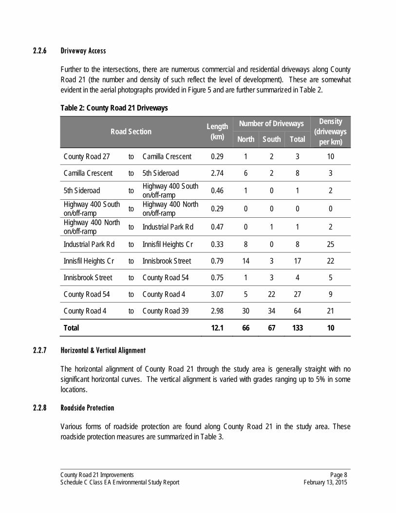
2.2.6 Driveway Access
Further to the intersections, there are numerous commercial and residential driveways along County Road 21 (the number and density of such reflect the level of development). These are somewhat evident in the aerial photographs provided in Figure 5 and are further summarized in Table 2.
Table 2: County Road 21 Driveways
Road Section Length
(km)
Number of Driveways Density (driveways
per km) North South Total
County Road 27 to Camilla Crescent 0.29 1 2 3 10
Camilla Crescent to 5th Sideroad 2.74 6 2 8 3
5th Sideroad to Highway 400 South on/off-ramp
0.46 1 0 1 2
Highway 400 South on/off-ramp
to Highway 400 North on/off-ramp
0.29 0 0 0 0
Highway 400 North on/off-ramp to Industrial Park Rd 0.47 0 1 1 2
Industrial Park Rd to Innisfil Heights Cr 0.33 8 0 8 25
Innisfil Heights Cr to Innisbrook Street 0.79 14 3 17 22
Innisbrook Street to County Road 54 0.75 1 3 4 5
County Road 54 to County Road 4 3.07 5 22 27 9
County Road 4 to County Road 39 2.98 30 34 64 21
Total 12.1 66 67 133 10
2.2.7 Horizontal & Vertical Alignment
The horizontal alignment of County Road 21 through the study area is generally straight with no significant horizontal curves. The vertical alignment is varied with grades ranging up to 5% in some locations.
2.2.8 Roadside Protection
Various forms of roadside protection are found along County Road 21 in the study area. These roadside protection measures are summarized in Table 3.

County Road 21 Improvements Schedule C Class EA Environmental Study Report
Page 9 February 13, 2015
Table 3: County Road 21 Roadside Protection
From To Side Length Type
39 m east of CR 27 122 m east of CR 27 N 83 m steel beam guide rail
CR 27 62 m east of CR 27 S 50 m1 steel beam guide rail
127 m east of CR 27 9 m west of Camilla Cr N 159 m steel beam guide rail
82 m east of Cty Rd 53 147 m east of Cty Rd 53 N 65 m steel beam guide rail
68 m west of Hwy 400 Hwy 400 S 68 steel beam guide rail
26 m west of Hwy 400 Hwy 400 N 26 steel beam guide rail
Hwy 400 68 m east of Hwy 400 N 68 steel beam guide rail
Hwy 400 24 m east of Hwy 400 S 24 steel beam guide rail
260 m east of Innisfil Heights Crescent
430 m east of Innisfil Heights Crescent
N 170 m 3 cable guide rail
270 m east of Innisfil Heights Crescent
305 m east of Innisfil Heights Crescent
S 35 m 3 cable guide rail
315 m east of Innisfil Heights Crescent
435 m east of Innisfil Heights Crescent
S 120 m 3 cable guide rail
515 m east of Innisfil Heights Crescent
570 m east of Innisfil Heights Crescent
S 55 m 3 cable guide rail
50 m east of Innisbrook St 335 m east of Innisbrook St N 285 m 3 cable guide rail
95 m east of Innisbrook St 345 m east of Innisbrook St S 250 m 3 cable guide rail
340 m east of Innisbrook St 385 m east of Innisbrook St N 45 m 3 cable guide rail
355 m east of Innisbrook St 385 m east of Innisbrook St S 30 m 3 cable guide rail
110 m west of Cty Rd 54 60 m west of Cty Rd 54 S 50 m 3 cable guide rail
720 m west of Cty Rd 4 660 m west of Cty Rd 4 N 60 m posts only
720 m west of Cty Rd 4 630 m west of Cty Rd 4 S 90 m posts only
440 m west of Cty Rd 4 350 m west of Cty Rd 4 S 90 m posts only
430 m west of Cty Rd 4 350 m west of Cty Rd 4 N 80 m posts only
1 Guide rail continues around the SW corner of Cty Rd 27 intersection - length given is the portion on County Road 21 only

County Road 21 Improvements Schedule C Class EA Environmental Study Report
Page 10 February 13, 2015
2.2.9 Traffic Volumes
Traffic volumes for the section of County Road 21 from County Road 27 to County Road 39 were provided by Simcoe County, reflective of traffic counts completed in the Spring, Summer and Fall of 2013 (as provided in Appendix A).
The average weekday traffic volumes (AWDT) and weekday peak hour directional volumes are summarized in Table 4 (volumes are rounded to multiples of 50). Overall, the summer daily volumes are approximately +/- 10% compared to the spring and fall volumes. The peak hour volumes observed during the spring and fall seasons are generally greater than the summer peak hour volumes. Therefore, no significant seasonal trend has been applied to County Road 21. In considering the peak hour volumes, the AM peak represents approximately 7% of the daily volume whereas the PM peak represents 9% of the daily volume.
Table 4: 2013 Traffic Volumes on County Road 21
Section Season AWDT AM Peak Hour Volume PM Peak Hour Volume
EB WB Total EB WB Total
021-05 Cty Rd 27 to
5 S/R
Spring 9250 450 200 650 350 500 850
Summer 9400 450 150 600 350 500 850
Fall 9000 500 200 700 400 500 900
021-04 5 S/R to Hwy 400
Spring 13050 550 350 900 450 850 1300
Summer 13500 550 250 800 400 750 1150
Fall 13050 550 300 850 450 800 1250
021-03 Hwy 400 to Cty
Rd 54
Spring 15450 350 750 1100 900 500 1400
Summer 13000 300 450 750 800 500 1300
Fall 13150 300 650 950 700 450 1150
021-02 Cty Rd 54 to
Cty Rd 4
Spring 12850 300 550 850 700 400 1100
Summer 12550 200 600 800 700 350 1050
Fall 11050 250 500 750 550 350 900
021-01 Cty Rd 4 to Cty Rd 39
Spring 12450 300 500 800 550 350 900
Summer 12350 350 350 700 550 400 950
Fall 11850 250 500 750 650 350 1000

County Road 21 Improvements Schedule C Class EA Environmental Study Report
Page 11 February 13, 2015
2.2.10 Roadside Drainage
With the exception of a small number of short stretches with curb and gutter, County Road 21 currently has a rural cross-section, utilizing ditches to manage stormwater run-off. Based on site visits, the existing ditches appear to be functioning as intended and hence a rural section will be maintained for the improvement alternatives except where curb and gutter is present under existing conditions or where right-of-way constraints necessitate an urban cross-section.
2.2.11 Water Crossings
There are 11 water crossings passing underneath County Road 21, as summarized in Table 5. The corresponding crossing locations and photographs of such are provided in Figure 5 and Figure 6.
Table 5: Water Crossings
Culvert Location Culvert Material
1 1,100 metres east of County Road 27 steel with concrete collar or concrete
2 365 metres west of 5th Sideroad steel
3 130 metres west of Industrial Park Road corrugated steel
4 370 metres east of Innisfil Heights Crescent corrugated steel
5 450 metres west of County Road 54 corrugated steel
6 490 metres east of County Road 54 corrugated steel
7 1,310 metres east of County Road 54 Lovers Creek crossing reinforced concrete box culvert
8 690 metres west of County Road 4 corrugated steel
9 410 metres west of County Road 4 corrugated steel
10 930 metres east of County Road 4 corrugated steel
11 1,130 metres west of County Road 39 corrugated steel
As noted, most of the crossings consist of steel and concrete pipe culverts. Lover’s Creek, which flows in a northerly direction towards Kempenfelt Bay, passes under Bridge No. 021047, a concrete box culvert located 1.3 km east of County Road 54. As per the County’s 2006 inspection, the Lover’s
County Road 21 Improvements Schedule C Class EA Environmental Study Report
Page 12 February 13, 2015
Creek concrete box culvert is not wide enough to accommodate the proposed widening and has been identified for full replacement.
2.2.12 Utilities
There are overhead utility services along both sides of County Road 21. In this regard, it is expected that some utility poles will have to be relocated, pending the final alignment and road configuration of any recommended improvements.
A natural gas pipeline is located within the right-of-way to the north of the existing road throughout the study area. A natural gas substation is located approximately 640 metres east of County Road 27.
In the eastern portion of the study area, a water main is located within the right-of-way to the south of the existing road.
2.3 Future Conditions
The need for improvements has also been considered in context of future conditions - namely traffic volumes and expected operations.
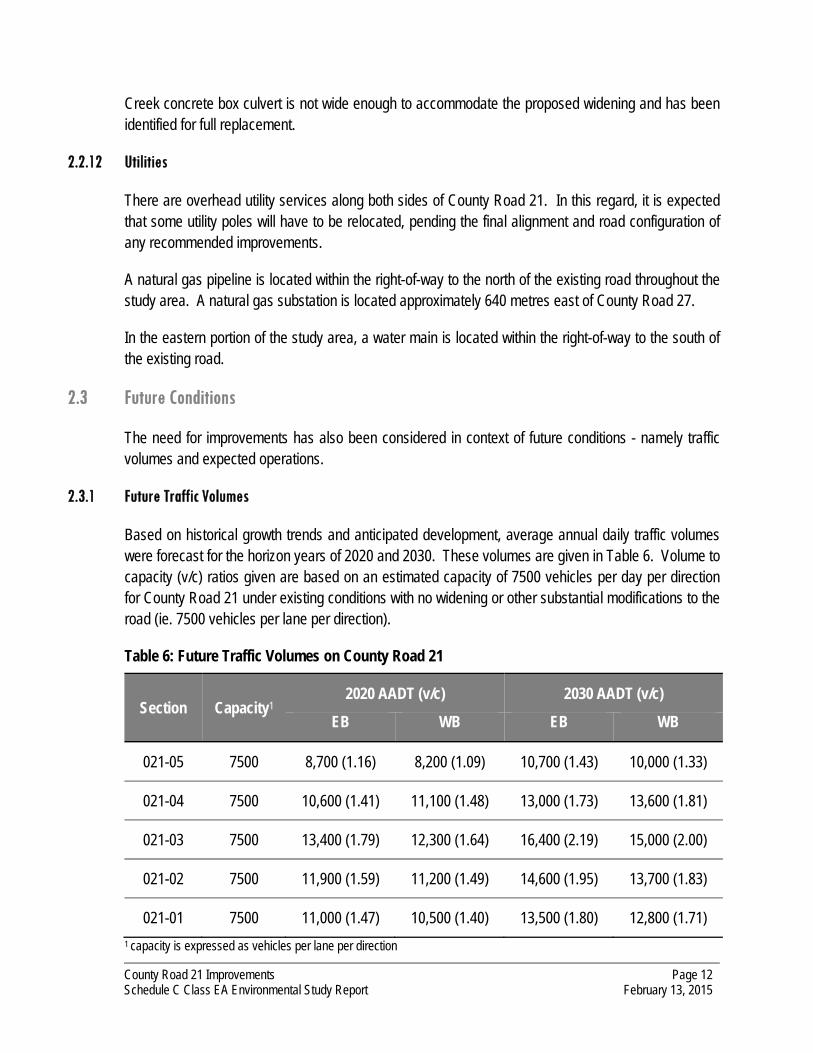
2.3.1 Future Traffic Volumes
Based on historical growth trends and anticipated development, average annual daily traffic volumes were forecast for the horizon years of 2020 and 2030. These volumes are given in Table 6. Volume to capacity (v/c) ratios given are based on an estimated capacity of 7500 vehicles per day per direction for County Road 21 under existing conditions with no widening or other substantial modifications to the road (ie. 7500 vehicles per lane per direction).
Table 6: Future Traffic Volumes on County Road 21
Section Capacity1 2020 AADT (v/c) 2030 AADT (v/c)
EB WB EB WB
021-05 7500 8,700 (1.16) 8,200 (1.09) 10,700 (1.43) 10,000 (1.33)
021-04 7500 10,600 (1.41) 11,100 (1.48) 13,000 (1.73) 13,600 (1.81)
021-03 7500 13,400 (1.79) 12,300 (1.64) 16,400 (2.19) 15,000 (2.00)
021-02 7500 11,900 (1.59) 11,200 (1.49) 14,600 (1.95) 13,700 (1.83)
021-01 7500 11,000 (1.47) 10,500 (1.40) 13,500 (1.80) 12,800 (1.71)
1 capacity is expressed as vehicles per lane per direction

County Road 21 Improvements Schedule C Class EA Environmental Study Report
Page 13 February 13, 2015
The recommended maximum threshold given in the Simcoe County Transportation Master Plan for consideration of road widening is a volume to capacity ratio (v/c) of 0.85 (ie. the road is operating at 85% of the available capacity). As can be seen in Table 6, this threshold will be significantly exceeded in 2020 and 2030. This indicates that the existing 2-lane road has reached its effective capacity at several locations and will not be able to properly accommodate future anticipated demand - additional road capacity will be required.
2.4 Problem Statement
In consideration of the existing conditions, projected future traffic volumes and corresponding operating levels, a Problem Statement has been defined. The Problem Statement, which sets the framework for the remainder of the study, is as follows:
That existing traffic and infrastructure deficiencies along the subject length of County Road 21 be corrected in an environmentally friendly manner, in consideration of future traffic needs, current County standards and the safe and efficient traffic operations for all road users.

County Road 21 Improvements Schedule C Class EA Environmental Study Report
Page 14 February 13, 2015
3 Consultation - Study Commencement
As per the Class EA process (refer to Figure 1), there are a number of points of stakeholder contact. The first point of contact, as discussed in this chapter, is the Notice of Study Commencement, which is used to inform the general public and stakeholders of the start of the study. The remaining points of contact are discussed further in the report following the chronological order in which they occurred.
3.1 Notification
A Notice of Study Commencement, which is a discretionary point of contact, was issued to all property owners (as determined from Simcoe County’s municipal records) along County Road 21, County Road 4 and 5th Sideroad within the study area on December 15, 2009. A notice was also published in the Innisfil Scope newspaper on December 16, 2009 and December 23, 2009 and in the Barrie Advance newspaper on December 17, 2009 and December 24, 2009. The notice identified the study area, the study methodology and Class EA guidelines to be followed. In addition, it invited public input and comments early in the process such that they could be considered in the overall study design and completion. A copy of the Notice of Study Commencement is provided in Appendix B.
Similar notices were also submitted to the appropriate review agencies, stakeholder groups and special interest groups, a listing of which is provided in Appendix B.
3.2 Public Comments
Input was received from stakeholders in response to the notice of study commencement. A total of 3 letters or emails were received (included in Appendix B). A summary of the comments received and their responses is given in Table 7.

County Road 21 Improvements Schedule C Class EA Environmental Study Report
Page 15 February 13, 2015
Table 7: Public Comments - Study Commencement
No. Public Comments Response to Comments
1 County Road 21 is heavily used by farmers to move equipment. This should be considered in the study/design.
Widening to 4 lanes and upgrading County Road 21 to current standards should improve conditions for agricultural use.
2 Widening and resurfacing of County Road 21 is long overdue and should begin as soon as possible.
Construction will not occur until the completion of the Class EA and corresponding engineeirng design.
Highest priority section is County Road 21 between Highway 400 and County Road 4.
Timing and phasing will be determined by the County subject to budget.
The Class EA should also review 10th Sideroad in the vicinity of County Road 21 for safety issues
The County Road 21 / County Road 54 (10th Sideroad) intersection has been recently improved.
3 Will the County or Town pay for re-location of our water supply in the event of contamination or reduced flow?
Specific property impacts have not yet been identified; the study will address methods to minimize, if not eliminate, negative impacts. If a road widening is required and a resident’s well is located within the area of the widening, there would be consideration for the relocation of the well as part of the land compensation.
Will the County or Town be compensating property owners for loss of value due to the project?
There are no case studies to substantiate loss of value. In some cases, land values may increase. The County does not provide compensation for any changes in land value.
Are there any plans to reduce the posted speed limit on County Road 21 (particularly in the section posted 60 km/h) or to increase police presence to reduce speeders and reckless drivers?
Reductions in speed limits will be reviewed by the County as development occurs. Increased police presence is not under the County’s control.
3.3 Agency Comments
Letters or emails were received from 2 agencies in response to the Notice of Study Commencement, copies of which are provided in Appendix B and summarized below:
Enbridge Gas Distribution
Enbridge has buried plant in numerous locations throughout the study area.

County Road 21 Improvements Schedule C Class EA Environmental Study Report
Page 16 February 13, 2015
Currently the scope of the project is too general to determine if a conflict exists. During the engineering design, provide copies of the plans for review.
Ontario Realty Corporation (ORC)
A preliminary review indicates that there are no ORC-managed properties within the study area. Please remove ORC from the circulation list for the project.

County Road 21 Improvements Schedule C Class EA Environmental Study Report
Page 17 February 13, 2015
4 Alternative Solutions
A number of reasonable and feasible solutions to addressing the Problem Statement were developed and are otherwise addressed in this chapter.
4.1 Alternative A - Do Nothing
The Do Nothing alternative corresponds to the existing conditions and serves as a benchmark to confirm any future improvements. Under this alternative, no improvements or changes to the road system would be made to solve the identified problem and as such, the problem would remain and, in fact, worsen as traffic volumes continue to increase over time. While this would not satisfy the objectives of the County to improve traffic operations, a Do Nothing alternative is suggested for consideration as an alternative in the Class EA guidelines for comparison purposes. A decision to do nothing would typically be made when the costs of all other alternatives, either financial and/or environmental, significantly outweigh the benefits.
4.2 Alternative B - Reduce Travel Demands
Rather than increase road capacity, this alternative focuses on reducing the overall travel demands on County Road 21, thus negating the need for capacity based improvements. Means to achieve this include increased use of non-auto base travel (transit, cycling and walking), increased occupancy and ridesharing (more riders per car translates to fewer trips), telecommuting (working from home) and flex hours (shifting working hours to avoid the peak hours). To accommodate such, additional initiatives would have to be introduced (ie. improved transit service, extended pedestrian linkages, etc.).
4.3 Alternative C - Alternative Travel Route
Alternative C would entail using reserve capacity on alternate travel routes to County Road 21 to accommodate existing and future travel demands.
4.4 Alternative D - Reconstruct County Road 21 & Intersection Improvements
Rather than widening the entire length of County Road 21 from County Road 27 to County Road 39, this alternative would attempt to address the capacity deficiencies and operational issues along County Road 21 by constructing improvements at intersections only, and reconstructing County Road 21 to a 2-lane cross section, similar to existing conditions. Examples of potential intersection improvements that might be considered are:
new or extended left and/or right turn lanes;
right turn channelization;

County Road 21 Improvements Schedule C Class EA Environmental Study Report
Page 18 February 13, 2015
changes to the intersection control (eg. changing from two-way stop control to all-way stop control, or from stop control to signals);
at signalized intersections, revised signal timings or the addition of new signal phases (eg. protected left turn or advanced green); and
minor changes to horizontal or vertical alignment through the intersection.
It should be noted that intersection improvements on County Road 21 at County Road 4, 5th Sideroad, and 10th Sideroad have been considered under separate studies and are not within the scope of this study or this alternative.
4.5 Alternative E - Widen County Road 21 to 4 lanes to the North
This alternative would entail widening County Road 21 to a 4-lane cross-section by increasing the platform and pavement width to the north of the existing road. This alternative would generally require acquisition of property on the north side of County Road 21 to increase the right-of-way width and relocation of utilities, ditches and other features to the north of the existing road.
4.6 Alternative F - Widen County Road 21 to 4 lanes to the South
Similar to Alternative E, this alternative would entail increasing the cross-section of County Road 21 to 4 lanes. However, in this alternative, the widening would be done to the south of the existing road. This alternative would generally require acquisition of property to the south of the existing right-of-way and relocation of utilities, ditches, and other features on the south side of the existing road.
4.7 Alternative G - Widen County Road 21 to 4 lanes Equally on Both Sides
This alternative would entail widening County Road 21 to 4 lanes by widening to both the north and south to maintain the existing centreline. This alternative would generally require property acquisition and relocation of utilities, ditches and other features on both sides of the road, though to a lesser width on either side than what would be required for Alternative E or F.

County Road 21 Improvements Schedule C Class EA Environmental Study Report
Page 19 February 13, 2015
5 Environment Inventories - Alternative Solutions
A description of the study area has been developed considering the identified alternative solutions and considering the following environments:
physical environment;
natural environment
social environment;
cultural/heritage environment; and
economic environment.
In accordance with the Class EA framework (as per Figure 1), detailed investigations and analyses with respect to the environment inventories were not required at this point in the study. Rather, data was obtained based on a number of site visits and a review of secondary information pertaining to the study area. The purpose of the inventories is to provide the information from which the assessment of the alternative solutions can be based. Brief descriptions of the various environments investigated are provided below.
5.1 Physical Environment
The physical environment pertains to the transportation system and utility/infrastructure systems within the area.
The transportation network as it pertains to this study includes County Road 21 between County Road 27 and County Road 39. Details with respect to the road system were previously provided in Section 2.2.
There are overhead utility services along this section of County Road 21 and thus it is expected that some poles will have to be relocated, pending the final alignment and road configuration. In addition, there is a natural gas pipeline within the right-of-way to the north of the existing road that may conflict with certain alternatives. Due to the cost of relocating these hydro poles and natural gas pipeline, the impacts to the utilities may have a significant impact on the final alternative chosen for the widening.
The majority of the subject length of County Road 21 utilizes open ditches and surface flows as a storm drainage system. There are limited sections of storm sewers at select intersections.

County Road 21 Improvements Schedule C Class EA Environmental Study Report
Page 20 February 13, 2015
5.2 Natural Environment
Azimuth Environmental Consulting Inc. evaluated the site area from an ecological perspective, findings of which are summarized below (the full reports are provided in Appendix C). Two reports were completed: one study evaluating the area west of Highway 400, the other study addressing the area east of Highway 400. Streams and evaluated wetlands located in the area are illustrated in Figure 7, as per the County of Simcoe Official Plan.
The study area is comprised mostly of disturbed old field meadow vegetation, agricultural lands, patches of remnant forest or manicured lawns of rural residences. The area west of Highway 400 contains one watercourse and one unevaluated wetland. East of Highway 400, the Lover’s Creek provincially significant wetland (PSW) is dominated by natural, relatively undisturbed wetland habitat.
Lover’s Creek functions as a cold water watercourse, providing important ground water discharge and recharge functions within a natural heritage system that contains stream corridors, Environmentally Significant Areas (ESA’s), wetlands, and significant woodlands. Stratum I and II deer yards associated with the wetland are contained within the study area east of Highway 400.
Of the 5 endangered bird species confirmed to be breeding within the two 10 km2 Ontario Breeding Bird Atlas Database survey squares encompassing the study area, only the Canada Warbler and Common Nighthawk have the potential to be present. There is potential for amphibian breeding within the small wetland adjacent to the Lawson Drain and within the vicinity of the Lover’s Creek wetland.
West of Highway 400, the Lawson Drain is a warm water watercourse with the potential to provide fish habitat, but which is not currently used by fish except potentially in elevated flow conditions. Channel realignments and culvert extensions (or replacements) on the Lawson Drain may be required based on the engineering design for the road widening. A sediment and erosion control program as well as best management practices (BMP’s) for work near watercourses should be integrated into the contract package for the selected preferred design for the project. East of Highway 400, there are 9 sites where watercourses are located in proximity to County Road 21. Six culverts support watercourse crossings under County Road 21 on tributaries of Lover’s Creek, the main branch of Lover’s Creek, and Hewitt’s Creek. Three sites include watercourses within the roadside ditch of the right-of-way. All watercourses are managed as cold water streams classified as fish habitat and are capable of directly or indirectly supporting Brook Trout and Sculpin. The replacement of the concrete box culvert at Lover’s Creek should occur “in the dry”, and may require the flow of the Creek to be temporarily diverted during construction.
Road works associated with the widening will result in the elimination of riparian vegetation and land clearing of areas of forest edge within the road allowance. Removal of this vegetation will not result in negative impact to the ecological function of the vegetation as habitat adjacent to roads offers limited ecological function.

County Road 21 Improvements Schedule C Class EA Environmental Study Report
Page 21 February 13, 2015
5.3 Social Environment
A review of the social environment focused on existing residential dwellings and/or commercial properties that could be impacted by the road widening. In addition, potential impacts to public institutions and service facilities were also considered. Land use designations for the study area, as per the County of Simcoe Official Plan, are illustrated in Figure 8.
The main impact expected to residential dwellings along County Road 21 will be land expropriation (affecting lawns, driveways, trees, etc.) and widening of the road platform. In cases where the proposed right-of-way would impact an existing building, the reduced 36 metre right-of-way could be warranted (acceptable where constraints exist). Alternatively, the cross-section of the proposed road could be altered to avoid any impacts to existing buildings (ie. consider narrower lanes or shoulders, urbanize vs open ditches).
There are several commercial properties within the subject area as follows:
commercial plaza located east of County Road 27 (south side of County Road 21);
highway commercial area east of Highway 400 (both north and south of County Road 21);
Spring Tree Farm Corporation Retail Centre east of the Community Centre (south side);
Spring Tree Farm Corporation Garden Centre east of Lover’s Creek (south side);
commercial properties at the intersection of County Road 4 with County Road 21 (north and south side).
These businesses and their customers will be temporarily affected by proposed road works and any associated road closures and/or detours. However, these will be short term impacts and any alternative proposing widening of County Road 21 will impact commercial properties equally.
The southeast corner of the 5th Sideroad and County Road 21 intersection is the proposed site of a “Smart Centre” (shopping centre). As part of the proposed site plan, a road widening is proposed to be dedicated along Innisfil Beach Road that will accommodate a widening of County Road 21 to four lanes (this was considered as part of the Class EA prepared for the intersections of County Road 21 with 5th Sideroad and County Road 4).
Agricultural land throughout the study area will be affected by any proposed widening, as additional property will need to be acquired from adjacent landowners in order to accommodate any road widening.
With regards to institutional buildings, the Innisfil Recreational Complex shares an access with the South Simcoe Police Service on the south side of County Road 21, east of County Road 4. Other institutional uses within the subject area are located west of County Road 39, namely the Town of

County Road 21 Improvements Schedule C Class EA Environmental Study Report
Page 22 February 13, 2015
Innisfil Lakeshore Water Reservoir (north side), the Innisfil Veterinary Hospital (north side), and the Innisfil Community Church (south side). Similar to the commercial and residential impacts, the main impact to institutional land uses will be associated with the required land acquisition.
5.4 Cultural/Heritage Environment
This environment encompasses archaeological sites and built heritage interest.
York North Archaeological Services Inc. completed a Stage I and Stage II Archaeological/Heritage Assessment of the affected lands with respect to the archaeological environment (archaeology and built heritage), the results of which are summarized below (the full report is provided in Appendix D). The Stage I assessment conducted by York North suggested that the potential for the presence of significant prehistoric or historic archaeological/ heritage resources within the boundaries of the study area ranged from high to low. Subsequent to the Stage I assessment, a Stage II archaeological/heritage assessment has been completed for the areas identified as high or moderate potential. The supplementary investigation involved a combination of pedestrian surveys and shovel testing along County Road 21.
The Stage II archaeological/heritage assessment found nothing of archaeological significance. During the Stage II survey, the field investigation team was denied access to some properties within the study area by the property owners; the specific locations are identified in the Stage II Archaeological/Heritage Assessment Report (Appendix D). It is recommended that a field investigation be carried out prior to construction at any location that falls within the proposed ROW and where access to said location was previously denied (recognizing that the Stage II Archaeological Assessment is only required within the proposed ROW).
As no archaeologically significant features were identified within the study area, the cultural/heritage environmental impacts of any of the alternatives are considered negligible.
5.5 Economic Environment
With respect to the economic environment, this considers the associated costs to be incurred in constructing the road improvements. The costs have been considered in relation to the extent of existing road requiring upgrades/reconstruction and/or the extent of new road construction required. For the purpose of the preliminary assessments, the costs were considered on a qualitative basis only (eg. least costly, most costly).
In addition, impacts to abutting lands have also been considered as part of the economic environment given the associated costs to obtain any required lands. However, no value has been associated with such acquisition.

County Road 21 Improvements Schedule C Class EA Environmental Study Report
Page 23 February 13, 2015
As discussed under the social environment assessment, there are also economic impacts associated with the existing farming activity, businesses or commercial establishments within the study area and the losses that would be incurred under each development option.

County Road 21 Improvements Schedule C Class EA Environmental Study Report
Page 24 February 13, 2015
6 Evaluation of Alternative Solutions
This section will discuss the evaluation of the alternative solutions as previously described, the results of which are considered preliminary given the need to solicit agency and public input. The evaluation is descriptive or qualitative in nature allowing for a comparative evaluation of the pros and cons associated with each alternative solution.
6.1 Initial Screening
In order to limit the list of alternatives to those that are most practical, certain alternatives were pre-screened and not carried forward through the formal evaluation. They have been included in this report to demonstrate that multiple approaches were considered in addressing the Problem Statement
The following alternatives were not carried forward in the evaluation process for reasons described in the discussion below.
Alternative A - Do Nothing is not considered appropriate in that it does not address the problem statement - road capacity deficiencies will otherwise persist and worsen with time. These in turn will lead to other detrimental impacts as previously noted - increased congestion, traffic noise, travel delays, etc.
While Alternative B - Reduce Travel Demands is expected to have positive benefits, the extent of such is not considered sufficient to address the noted capacity deficiencies.
Under Alternative C - Alternative Travel Routes, while some motorists are likely to seek out alternative travel routes as congested conditions arise on County Road 21, this is not considered a feasible solution given the additional travel required and capacity constraint issues on the alternative route identified. As noted in the County of Simcoe Transportation Master Plan, the available alternative routes are expected to experience volumes at or over capacity themselves by 2031. This indicates that diversion onto these routes may not result in a significant time savings for drivers and therefore not be used to a high degree, and also that any use of these alternative routes may create negative spillover effects as the additional congestion induces the drivers on those routes to divert to avoid congestion themselves. For these reasons, Alternative C does not address the needs identified in the problem statement and is therefore not carried forward.
Alternative D - Reconstruct & Intersection Improvements will address the existing deficiencies with respect to road structure condition and intersection operations. However, the resulting road system is not considered sufficient in its entirety to address the future travel demands given the increases in traffic volumes anticipated. Alternative D will not be carried forward in the evaluation process.
6.2 Evaluation Criteria
In completing the evaluation, a number of criteria were considered. Criteria have been divided into 5 major groups: Social Environment, Natural Environment, Physical Environment, Economic

County Road 21 Improvements Schedule C Class EA Environmental Study Report
Page 25 February 13, 2015
Environment and Cultural/Heritage Environment. The effects of the alternatives are identified based on the criteria within each group. Groups and criteria are outlined below.
Physical Environment
road geometry & alignment
traffic operations
utility conflicts & impacts
Cultural/Heritage Environment
archaeological impacts
built heritage impacts
First Nations impacts
Natural Environment
vegetation impacts
wildlife/terrestrial impacts
fisheries/aquatic impacts
Economic Environment
construction costs
land acquisition costs
Social Environment
property/development impacts
noise impacts
To facilitate the evaluation of the 12 kilometre length of County Road 21, the road has been divided into zones as follows:
Zone 1 - 80 m East of County Road 27 to 620 m East of County Road 27;
Zone 2 - 620 m East of County Road 27 to Highway 400 South On-Off Ramps;
Zone 3 - Highway 400 North On-Off Ramps to 200 m West of County Road 54;
Zone 4 - 200 m East of County Road 54 to County Road 4; and
Zone 5 - County Road 4 to 200 m West of County Road 39.
6.3 Environmental Impacts
The potential impacts associated with each alternative are noted in Table 8 through Table 12 and discussed in further detail below.
The natural environment impact evaluations were derived from Natural Environmental Existing Conditions Report by Azimuth Environmental Consulting, included as Appendix C.

County Road 21 Improvements Schedule C Class EA Environmental Study Report
Page 26 February 13, 2015
Table 8: Evaluation of Alternative Solutions - Zone 1
Alternatives Social Environment Natural Environment Physical Environment Cultural/Heritage Environment Economic Environment Overall Ranking
Alternative E Widen on the North Side
greatest impact to abutting agricultural land
least impact to abutting residential/commercial land
each alternative is feasible from a natural environment perspective - impacts are minimal and/or can be readily mitigated
road must be aligned to match west limits (aligned to the centre)
transition length is required requires 2nd greatest number of
relocated hydro poles greatest potential impacts to natural
gas station
moderate archaeological potential Stage II archaeological assessment
recommended
comparable construction costs 2nd greatest cost associated with
hydro pole relocation
3rd place ranking
Alternative F Widen on the South Side
least impact to abutting agricultural land
greatest impact to abutting residential/commercial land
road must be aligned to match west limits (aligned to the centre)
transition length is required requires lowest number of relocated
hydro poles least potential impacts to natural
gas station
comparable construction and land acquisition costs
lowest cost associated with hydro pole relocation
2nd place ranking
Alternative G Widen Equally on Both Sides
2nd greatest impact to abutting agricultural land
2nd greatest impact to abutting residential/ commercial land
road alignment matches west limits (aligned to the centre)
requires greatest number of relocated hydro poles
2nd greatest potential impacts to natural gas station
comparable construction and land acquisition costs
highest cost associated with hydro pole relocation
1st place ranking

County Road 21 Improvements Schedule C Class EA Environmental Study Report
Page 27 February 13, 2015
Table 9: Evaluation of Alternative Solutions - Zone 2
Alternatives Social Environment Natural Environment Physical Environment Cultural/Heritage Environment Economic Environment Overall Ranking
Alternative E Widen on the North Side
greatest impact to abutting agricultural/residential land
least impact to abutting commercial land and natural area
Lawson Drain/Thornton Creek likely impacted by widening
either alternative is feasible from a natural environment perspective - impacts are minimal and/or can be readily mitigated
road must be aligned to match east limits (aligned to the centre)
transition length is required requires greatest number of
relocated hydro poles (comparable to Alt G)
moderate to high archaeological potential
Stage II archaeological assessment recommended
comparable construction costs greatest cost associated with hydro
pole relocation (comparable to Alt G)
3rd place ranking
Alternative F Widen on the South Side
least impact to abutting agricultural/residential land
greatest impact to abutting commercial land and natural area
road must be aligned to match east limits (aligned to the centre)
transition length is required requires lowest number of relocated
hydro poles
comparable construction costs lowest cost associated with hydro
pole relocation
1st place ranking
Alternative G Widen Equally on Both Sides
2nd greatest impact to abutting agricultural/ residential land
2nd greatest impact to abutting commercial land and natural area
road alignment matches east limits (aligned to the centre)
requires greatest number of relocated hydro poles (comparable to Alt E)
comparable construction costs greatest cost associated with hydro
pole relocation (comparable to Alt E)
2nd place ranking
Table 10: Evaluation of Alternative Solutions – Zone 3
Alternatives Social Environment Natural Environment Physical Environment Cultural/Heritage Environment Economic Environment Overall Ranking
Alternative E Widen on the North Side
least impact to abutting commercial land
greatest impact to abutting agricultural land and natural area
2nd greatest impact to abutting residential area Lover’s Creek tributary likely
impacted by widening either alternative is feasible from a
natural environment perspective - impacts are minimal and/or can be readily mitigated
road must be aligned to match west and east limits (aligned to the centre)
transition length is required requires 2nd greatest number of
relocated hydro poles
high archaeological potential Stage II archaeological assessment
recommended
comparable construction costs 2nd greatest cost associated with
hydro pole relocation
2nd place ranking
Alternative F Widen on the South Side
greatest impact to abutting residential/commercial land
least impact to abutting agricultural land and natural area
road must be aligned to match west and east limits (aligned to the centre)
transition length is required requires greatest number of
relocated hydro poles
comparable construction costs greatest cost associated with hydro
pole relocation
3rd place ranking
Alternative G Widen Equally on Both Sides
2nd greatest impact to abutting agricultural/ commercial land and natural area
Least impact to abutting residential land
road alignment matches west and east limits (aligned to the centre)
requires lowest number of relocated hydro poles
comparable construction costs lowest cost associated with hydro
pole relocation
1st place ranking
County Road 21 Improvements Schedule C Class EA Environmental Study Report
Page 28 February 13, 2015
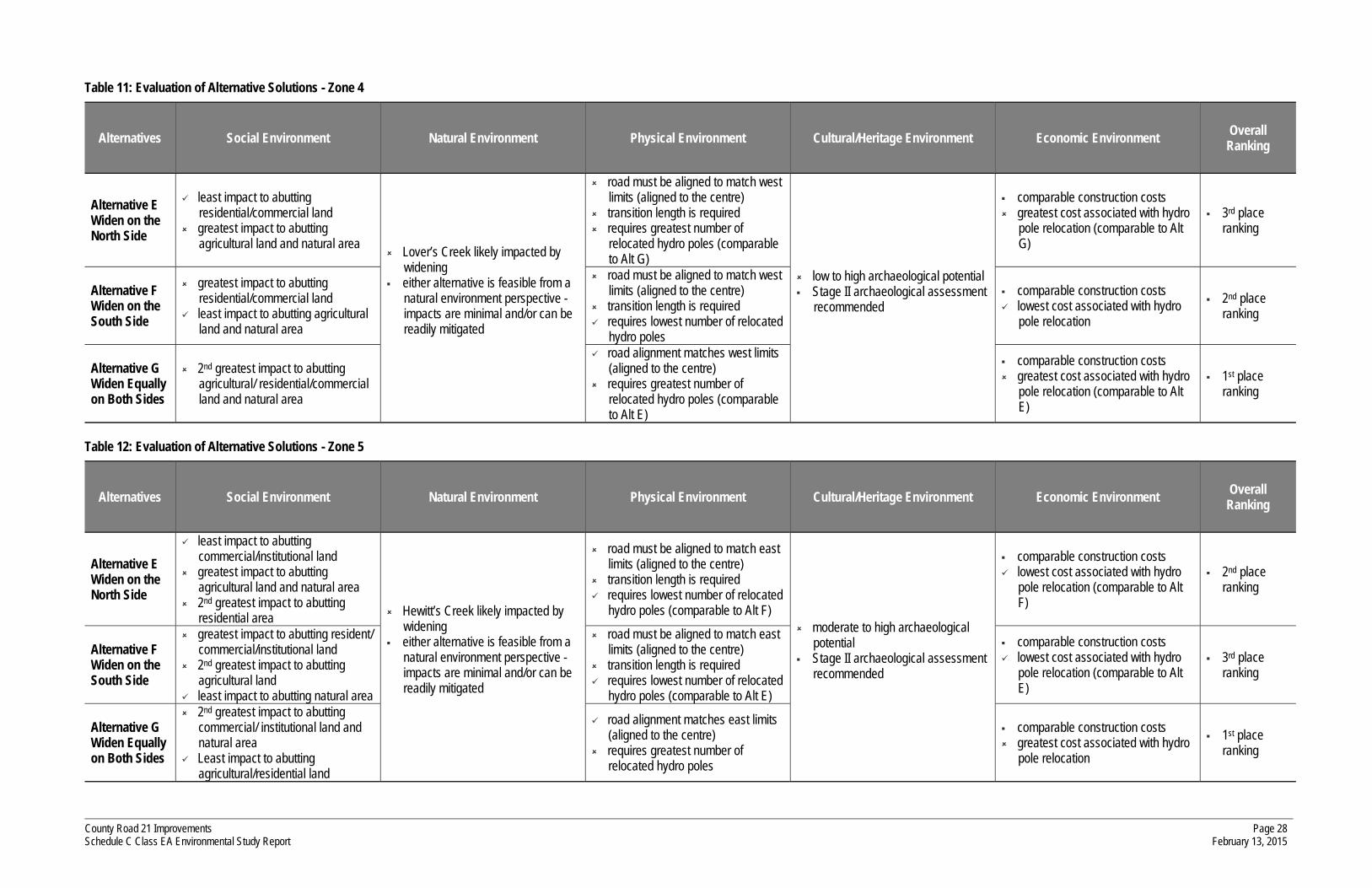
Table 11: Evaluation of Alternative Solutions - Zone 4
Alternatives Social Environment Natural Environment Physical Environment Cultural/Heritage Environment Economic Environment Overall Ranking
Alternative E Widen on the North Side
least impact to abutting residential/commercial land
greatest impact to abutting agricultural land and natural area
Lover’s Creek likely impacted by widening
either alternative is feasible from a natural environment perspective - impacts are minimal and/or can be readily mitigated
road must be aligned to match west limits (aligned to the centre)
transition length is required requires greatest number of
relocated hydro poles (comparable to Alt G)
low to high archaeological potential Stage II archaeological assessment
recommended
comparable construction costs greatest cost associated with hydro
pole relocation (comparable to Alt G)
3rd place ranking
Alternative F Widen on the South Side
greatest impact to abutting residential/commercial land
least impact to abutting agricultural land and natural area
road must be aligned to match west limits (aligned to the centre)
transition length is required requires lowest number of relocated
hydro poles
comparable construction costs lowest cost associated with hydro
pole relocation
2nd place ranking
Alternative G Widen Equally on Both Sides
2nd greatest impact to abutting agricultural/ residential/commercial land and natural area
road alignment matches west limits (aligned to the centre)
requires greatest number of relocated hydro poles (comparable to Alt E)
comparable construction costs greatest cost associated with hydro
pole relocation (comparable to Alt E)
1st place ranking
Table 12: Evaluation of Alternative Solutions - Zone 5
Alternatives Social Environment Natural Environment Physical Environment Cultural/Heritage Environment Economic Environment Overall Ranking
Alternative E Widen on the North Side
least impact to abutting commercial/institutional land
greatest impact to abutting agricultural land and natural area
2nd greatest impact to abutting residential area Hewitt’s Creek likely impacted by
widening either alternative is feasible from a
natural environment perspective - impacts are minimal and/or can be readily mitigated
road must be aligned to match east limits (aligned to the centre)
transition length is required requires lowest number of relocated
hydro poles (comparable to Alt F) moderate to high archaeological
potential Stage II archaeological assessment
recommended
comparable construction costs lowest cost associated with hydro
pole relocation (comparable to Alt F)
2nd place ranking
Alternative F Widen on the South Side
greatest impact to abutting resident/ commercial/institutional land
2nd greatest impact to abutting agricultural land
least impact to abutting natural area
road must be aligned to match east limits (aligned to the centre)
transition length is required requires lowest number of relocated
hydro poles (comparable to Alt E)
comparable construction costs lowest cost associated with hydro
pole relocation (comparable to Alt E)
3rd place ranking
Alternative G Widen Equally on Both Sides
2nd greatest impact to abutting commercial/ institutional land and natural area
Least impact to abutting agricultural/residential land
road alignment matches east limits (aligned to the centre)
requires greatest number of relocated hydro poles
comparable construction costs greatest cost associated with hydro
pole relocation
1st place ranking

County Road 21 Improvements Schedule C Class EA Environmental Study Report
Page 29 February 13, 2015
The Archaeological impact evaluations were derived from A Stage I Archaeological/Heritage Assessment of the Proposed Road Widening of County Road 21, From County Road 27 to County Road 39 and A Stage II Archaeological Assessment Of The Proposed Road Widening Of County Road 21, From County Road 27 To County Road 39 by York North Archaeological Services, included as Appendix D.
The Noise impact evaluations were derived from County Road 21 Reconstruction Traffic Noise Impact Study by R. Bouwmeester and Associates, included as Appendix E.
6.4 Recommended Solution
Based on the evaluation of the noted alternatives, Alternative G (widen to both sides) is ranked highest overall based on technical criteria, having received a first place ranking for all zones with the exception of Zone 2, where it was ranked second.
Alternative G is also preferred from an engineering and constructability perspective, as it is the best of the three alternatives to tie into the existing alignment at the project limits and would not require realignment of intersections along County Road 21.

County Road 21 Improvements Schedule C Class EA Environmental Study Report
Page 30 February 13, 2015
7 Stakeholder Consultation - PIC 1
In completing a Schedule C Class EA, there are 3 points of mandatory stakeholder contact as per the following (refer also to Figure 1):
the 1st point occurs towards the end of Phase 2 when a notice is issued inviting stakeholder comment and input via a Public Information Centre (referred to as PIC 1);
the 2nd second point occurs towards the of end of Phase 3 when a second Public Information Centre is held (PIC 2); and
the 3rd point of contact is upon completion of the planning process at which time a Notice of Completion is provided.
In keeping with the chronological order in documenting events in the order that they occurred, the first point of contact is discussed in this chapter; the remaining points of contact will be addressed in Chapter 12 and Chapter 14.
7.1 Purpose
The purpose of Public Information Centre 1 was to provide information to the public and agencies and seek their input with respect to the following:
identification of the problem;
development and evaluation of alternative solutions to the problem;
general inventory of the affected environments;
potential impacts of each alternative solutions to the environments considered;
identification of the preliminary recommended solution; and
discussion of remaining tasks to be undertaken in completing the Class EA..
7.2 Notification
In accordance with the Municipal Class EA guidelines, a notification of the Public Information Centre was issued inviting stakeholder comment and input. Stakeholders include review agencies, the public and other municipalities and thus notices were directed to each, in the same manner in which the Notice of Commencement was disseminated. Notices were also mailed to the area residents on September 3, 2010 and published in the Barrie Examiner on two separate occasions preceding the public information centres. Copies of the notices and distribution list are provided in Appendix F.

County Road 21 Improvements Schedule C Class EA Environmental Study Report
Page 31 February 13, 2015
7.3 Public Information Centre
The Public Information Centre was held on September 23, 2010 from 4:00 PM to 7:00 PM at the Innisfil Town Hall Community Rooms, 2101 County Road 21. No formal presentation was made but rather people were welcome to drop in during the above hours to review the materials and ask questions. Representatives from Simcoe County and C.C. Tatham & Associates were in attendance to answer any questions and provide assistance as necessary.
Various display boards were prepared for viewing by the public, a copy of which was made available on the County website following the meeting (as provided in Appendix F). Display boards addressed the following (specific to the intersection improvements):
study purpose and introduction which described the reasoning behind the undertaking;
the Municipal Class EA process and those tasks relevant to this study;
a review of the existing conditions;
problem identification detailing the travel demand (both existing and future) and operational issues necessitating the need for improvements;
alternative solutions the County Road 21 corridor;
an inventory of the natural environment;
preliminary assessment and identification of the recommended option;
the remaining steps to completion; and
contact details for additional information.
Forty-four people attended the Public Information Centre based on the sign-in sheets (a copy of which is provided in Appendix F), including representatives from the Town of Innisfil and many of the local residents.
7.4 Public Comments
Input was received from stakeholders either at PIC 1 or shortly thereafter via the comment sheets provided. A total of 13 comment sheets were returned (included in Appendix F). A summary of the comments received and their responses is provided in Table 13.
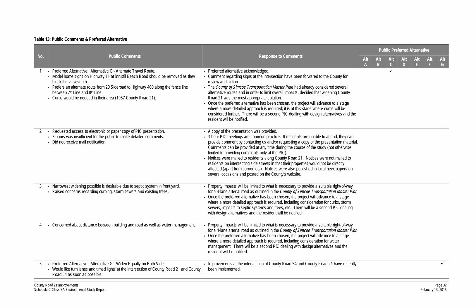
County Road 21 Improvements Schedule C Class EA Environmental Study Report
Page 32 February 13, 2015
Table 13: Public Comments & Preferred Alternative
No. Public Comments Response to Comments Public Preferred Alternative
Alt A
Alt B
Alt C
Alt D
Alt E
Alt F
Alt G
1 Preferred Alternative: Alternative C - Alternate Travel Route. Model home signs on Highway 11 at Innisfil Beach Road should be removed as they
block the view south. Prefers an alternate route from 20 Sideroad to Highway 400 along the fence line
between 7th Line and 8th Line. Curbs would be needed in their area (1957 County Road 21).
Preferred alternative acknowledged. Comment regarding signs at the intersection have been forwared to the County for
review and action. The County of Simcoe Transportation Master Plan had already considered several
alternative routes and in order to limit overall impacts, decided that widening County Road 21 was the most appropriate solution.
Once the preferred alternative has been chosen, the project will advance to a stage where a more detailed approach is required; it is at this stage where curbs will be considered further. There will be a second PIC dealing with design alternatives and the resident will be notified.
2 Requested access to electronic or paper copy of PIC presentation. 3 hours was insufficient for the public to make detailed comments. Did not receive mail notification.
A copy of the presentation was provided. 3 hour PIC meetings are common practice. If residents are unable to attend, they can
provide comment by contacting us and/or requesting a copy of the presentation material. Comments can be provided at any time during the course of the study (not otherwise limited to providing comments only at the PIC).
Notices were mailed to residents along County Road 21. Notices were not mailed to residents on intersecting side streets in that their properties would not be directly affected (apart from corner lots). Notices were also published in local newspapers on several occasions and posted on the County’s website.
3 Narrowest widening possible is desirable due to septic system in front yard. Raised concerns regarding curbing, storm sewers and existing trees.
Property impacts will be limited to what is necessary to provide a suitable right-of-way for a 4-lane arterial road as outlined in the County of Simcoe Transportation Master Plan
Once the preferred alternative has been chosen, the project will advance to a stage where a more detailed approach is required, including consideration for curbs, storm sewers, impacts to septic systems and trees, etc. There will be a second PIC dealing with design alternatives and the resident will be notified.
4 Concerned about distance between building and road as well as water management. Property impacts will be limited to what is necessary to provide a suitable right-of-way for a 4-lane arterial road as outlined in the County of Simcoe Transportation Master Plan
Once the preferred alternative has been chosen, the project will advance to a stage where a more detailed approach is required, including consideration for water management. There will be a second PIC dealing with design alternatives and the resident will be notified.
5 Preferred Alternative: Alternative G - Widen Equally on Both Sides. Would like turn lanes and timed lights at the intersection of County Road 21 and County
Road 54 as soon as possible.
Improvements at the intersection of County Road 54 and County Road 21 have recently been implemented.

County Road 21 Improvements Schedule C Class EA Environmental Study Report
Page 33 February 13, 2015
No. Public Comments Response to Comments Public Preferred Alternative
Alt A
Alt B
Alt C
Alt D
Alt E
Alt F
Alt G
6 Requested that residents remain informed. Advertising signs should be removed at several intersections. More speed limit signs and a greater police presence would help to deter speeding.
Residents will continue to be informed via notices in the local newspapers, notices sent by mail (for residents directly impacted) and a second PIC.
Comment regarding signs at the intersection have been forwared to the County for review and action.
Directed the resident to contact the police department concerning speeding on County Road 21.
7 What amount of frontage will be lost on south side from present road or from easement? Size of easement? Elevation change? Set back on hydro poles? Width of sidewalk? Curbs all the way? Drainage? Septic field in front of lot? Health dept. involvement? (County’s responsibilty, how determined and guaranteed) Time lines for start and completion? How is compensation determined? Requested drawing of their property and their neighbour’s property showing the various
alternatives.
A detailed drawing was provided showing the properties in question and the various alternatives.
Once the preferred alternative has been chosen, the project will advance to a stage where a more detailed approach is required, including consideration for width of sidewalk, hydro poles, curbs, septic fields, etc. There will be a second PIC dealing with design alternatives and the resident will be notified.
8 Preferred Alternative: Alternative C - Alternate Travel Route. Assuming the widening must occur, prefers Alternative G - Widen Equally on Both Sides.
Immediate improvements are necessary at County Road 54. Opposed to widening as it is not needed based on current traffic volumes. Suggested 7th Line as a possible alternate route. Concerned with destruction of environmentally sensitive wetlands. Various points on road where there are homes on both sides where impacts will be
greater. Why is the County widening County Road 21 while Town of Innisfil is constructing
medians down the middle of the road starting at the 20th Sideroad and onwards to the 25th Sideroad? Town of Innisfil has approved new development so close to County Road 21 that 4 lanes could not be provided.
Two levels of government need to create plans that are in agreement with each other. Options A, B, C, and D not truly options as County has laid groundwork to widen the
road. Doubts that Options F and G are truly options, due to land purchased by County from
landowners on the north side. Why is the public being consulted if the road widening and intersection improvements
have already been approved? Not fair to widen to one side of the road, prefers widening equally on both sides.
Improvements at the intersection of County Road 54 and County Road 21 have recently been implemented.
The County of Simcoe Transportation Master Plan had already considered several alternative routes and in order to limit overall impacts, decided that widening County Road 21 was the most appropriate solution.
The widening is to accommodate expected traffic volumes for the next 20 years. Property impacts will be limited to what is necessary to provide a suitable right-of-way
for a 4-lane arterial road as outlined in the County of Simcoe Transportation Master Plan.
A natural environment study was underaken by Azimuth Environmental Consulting Inc. In order for the project to proceed to the construction phase, it must be approved by several regulatory agencies. Preliminary findings inidcate that all impacts to the natural environment will be minimal and can be further mitigated.
The proposed widening of County Road 21 is planned between County Road 27 and County Road 39. The widening will be continued easterly to Jans Boulevard (undertaken by the Town), beyond which the road will transition back to 2 lanes.
The likely preferred option will be Alternative G - Widen Equally on Both Sides, as widening to the north or to the south would unfairly impact property owners, as noted.

County Road 21 Improvements Schedule C Class EA Environmental Study Report
Page 34 February 13, 2015
No. Public Comments Response to Comments Public Preferred Alternative
Alt A
Alt B
Alt C
Alt D
Alt E
Alt F
Alt G
9 Requested drawing of the intersection of 8th Line and 20th Sideroad. Engineering drawings were sent from the County to the resident.
10 Requested drawing of their property showing the various alternatives. A detailed drawing was provided showing the property in question and the various alternatives.
11 Requested drawing of their property showing the various alternatives. A detailed drawing was provided showing the property in question and the various alternatives.
12 When making provision on construction of the widening, the Town of Innisfil requested provisions for water and sanitary sewers as sewers may be provided up to Innisfil Heights.
The County will continue to inform the Town of Innisfil of any developments as the study progressses and will work with the Town to incorporate any additonal infrastructure needs.
13 Appreciated opportunity to see study plans and feels something must be done to improve the situation.
No action required.

County Road 21 Improvements Schedule C Class EA Environmental Study Report
Page 35 February 13, 2015
7.5 Agency Comment
Comment letters were received from 2 agencies, copies of which are provided in Appendix F and summarized below.
Town of Innisfil:
The Town of Innisfil requests that the design cross section for County Road 21 be amended to include a hard surface pedestrian/cyclist corridor within the right-of-way but not adjacent to the travelled lanes for the vehicular traffic.
The Town of Innisfil requests that the design cross section for County Road 21 be amended to include a servicing corridor for the installation of municipal sanitary sewers and municipal water mains.
Chippewas of Rama First Nation:
No comments other than a request that all future correspondence and inquiries be directed to the First Nation’s solicitor, with a copy to Rama First Nation.

County Road 21 Improvements Schedule C Class EA Environmental Study Report
Page 36 February 13, 2015
8 Preferred Solution
8.1 Preferred Solution
Based on the evaluation of the alternative solutions, which considered several technical criteria, Alternative G (widen equally on both sides) was identified as the preferred solution. Alternative G received a first place ranking for each of the road sections considered (with the exception of Section 2, where it ranked second). Alternative G is also preferred from an engineering and construction perspective, as it will readily transition to the existing road alignments at the project limits and at the intersections with 5th Sideroad, County Road 54 and County Road 4 (improvements at these locations, which have been addressed under separate studies, include widenings about the existing road centreline).
It is further noted that comments received during the PIC indicated that Alternative G was preferred over the other alternatives that were carried forward from the pre-screening process (ie. Alternatives E and F).
Therefore, Alternative G (widen to both sides) is selected as the preferred solution.
8.2 Confirmation of EA Schedule
As noted previously, the Class EA guidelines for a Schedule C undertaking apply to new facilities or major expansions to existing facilities where the cost of construction would exceed $2.4 million. In Section 1.1.3 it was noted that the County Road 21 widening project would follow the Schedule C process. The preferred solution to widen the road is a major expansion project that will incur an overall construction cost in excess of $2.4 million. As such, a Schedule C undertaking is confirmed as appropriate.

County Road 21 Improvements Schedule C Class EA Environmental Study Report
Page 37 February 13, 2015
9 Alternative Design Concepts for the Preferred Solution
Alternative design concepts for the preferred solution (ie. manner in which the preferred solution can be implemented) have been prepared to illustrate how the road is to be widened to 4 lanes while maintaining the existing centreline. The design concepts are provided in Figure 9 and described below.
9.1 Design Alternative G1 - 40 m Right-of-Way, Rural Cross-Section
Alternative G1 reflects the desired right-of-way width (40 metres) for County Road 21, as identified in the County of Simcoe Transportation Master Plan (the 40 metres right-of-way is also recommended for primary County Roads where an active transportation route or trail is provided within the right-of-way). This alternative provides the most flexibility for the accommodation of drainage and stormwater management features within the right-of-way and necessary side slope grading.
9.2 Design Alternative G2 - 36 m Right-of-Way, Rural Cross-Section
Alternative G2 reflects the preferred minimum right-of-way width (36 metres) for County Road 21 (as per the County of Simcoe Transportation Master Plan), to be considered where constraints otherwise preclude the implementation of a 40 metre right-of-way. It is noted that the Transportation Master Plan identifies a 36 metre ROW as the preferred minimum right-of-way to be considered for a primary arterial road. While this alternative may be somewhat limited in its ability to accommodate features such as active transportation trails, slope grading and stormwater management within the proposed right-of-way, it may be appropriate in areas where constraints exist.
9.3 Design Alternative G3 - Maintain Existing Right-of-Way, Urban Cross-Section
Alternative G3 reflects the provision of a 4-lane road within the existing right-of-way (provided that the existing right-of-way is not less than 26 metres). With a reduced right-of-way, it would not possible to accommodate expansive shoulders and open ditches and thus an urban cross-section would be constructed, consisting of curb and gutter with no ditches. While this alternative does not provide for open ditches (which are typically employed as stormwater management features in rural environments), it can generally accommodate sidewalks or multi-use paths within the associated boulevards.
9.4 Stormwater Management Considerations
There are several water crossings along County Road 21 through the study area; the largest of which is the Lovers Creek crossing. As the proposed road widening will result in additional storm water runoff (due to the increase in the hard surface area), the Ministry of the Environment requires that additional stormwater management (SWM) features be considered in the vicinity of the water crossings

County Road 21 Improvements Schedule C Class EA Environmental Study Report
Page 38 February 13, 2015
in order to control the quantity and quality of the storm water runoff entering the adjacent watercourses. A preliminary stormwater management design brief was prepared to address the stormwater management requirements along County Road 21 and gain approval of the overall stormwater management concept for purposes of considering it in the Class EA process and identifying any associated additional property requirements. The design brief was submitted to both the Nottawasaga Valley Conservation Authority (NVCA) who have jurisdiction to the west of Highway 400, and also to the Lake Simcoe Region Conservation Authority (LSRCA) who have jurisdiction to the east of Highway 400. The corresponding design brief is also attached as Appendix G.
As outlined in the design brief, enhanced linear ditches are proposed at strategic locations to act as retention ponds to control the quantity of water and settling ponds to control the quality of the water. Given the proposed configuration and size of the enhanced linear ditches, an additional 5 metres will be required on each side where such stormwater management features are required.
The resulting road cross-section required to accommodate the proposed stormwater management features on both sides is illustrated in Figure 10. As noted, a total right-of-way width of 50 metres is proposed (40 metres base right-of-way + 5 additional metres on either side to accommodate the enhanced ditch). It is noted that the 4-lane cross-section of the road is consistent with the other design concepts despite the additional right-of-way requirements (ie. the road platform width and configuration is unchanged).

County Road 21 Improvements Schedule C Class EA Environmental Study Report
Page 39 February 13, 2015
10 Environment Inventories - Alternative Design Concepts
The description of the study area as provided in Section 2.2 (Existing Conditions) and Chapter 5 (Environment Inventories) is consistent with the study area to be considered with respect to the alternative design concepts of the preferred solution. Implementing the preferred solution (Alternative G - Widen Equally on Both Sides) will not impact any environment features that have not otherwise been documented in this report. As such, the environment inventory provided in Chapter 5 of this report is considered comprehensive. A summary of the environment inventories is provided below.
Physical Environment
open ditch drainage system
hydro poles & utility pedestals
natural gas pipeline
water main (County Road 4 to 20th Sideroad)
water crossing structures
Social Environment
residential properties
commercial/agricultural properties
institutional properties
noise impacts
Natural Environment
Lover’s Creek (PSW) and other watercourses
fish habitat (warm & cold water)
wildlife (species at risk - birds, turtles, etc)
riparian vegetation
remnant forests, agricultural land
Cultural/Heritage Environment
no areas of archaeological significance within study area
Economic Environment
construction costs
land acquisition costs
10.1 Physical Environment
With respect to the physical environment of the study area, primary consideration is given to the existing utility and service infrastructure along County Road 21 (ie. hydro poles, utility pedestals, natural gas pipelines, etc.) and the potential relocation of such. Furthermore, the existing open ditch drainage will be impacted (ie. realignment or enhancement of the existing ditches or replacement with curb, gutter and storm drain).

County Road 21 Improvements Schedule C Class EA Environmental Study Report
Page 40 February 13, 2015
10.2 Natural Environment
An Environmental Impact Study of the preferred solution was completed by Azimuth Environmental Consulting for the County Road 21 widening entitled Natural Environment Impact Assessment Report - County Road 21 Improvements5. A summary of their findings is provided below, whereas the corresponding report is provided in Appendix H.
10.2.1 Vegetation
There are 19 vegetation communities within the project study area, none of which are considered rare in the Province. A total of 6.3 hectares of vegetation will be lost and/or altered with the widening of County Road 21. Of the 6.3 hectares, 3.2 hectares is comprised of terrestrial upland vegetation communities and the remaining 3.1 hectares is comprised of swamp and marsh wetland habitat.
All vegetation lost will be within the area of disturbance of the proposed expanded road. Removal of this vegetation will not result in negative impact to the ecological function of the vegetation as habitat adjacent to roads offers limited ecological function. In addition, species that typically utilize edge habitats are common and tolerant to disturbance.
The two Butternut trees located on adjacent privately owned lands should be assessed with respect to their overall health using MNR's required assessment protocol. The assessment should be conducted once the County has acquired the property needed to expand the existing right-of-way for the proposed road widening.
10.2.2 Wildlife
Mammalian species observed within the study area are common to disturbed vegetation communities. As such, no impacts to mammalian populations are expected as a result of the proposed road improvements.
Marginal habitat for Species at Risk is present outside of the proposed road improvements. All habitats present within the development footprint of the proposed road improvements is considered edge habitat, and does not function as habitat for species at risk. Therefore, all species at risk identified will remain post-development, outside of the development footprint.
Potential anuran amphibian breeding habitat may be lost as a result of the proposed road widening; however, this loss is not significant given the extensive amphibian habitat present within the general area. Therefore, there will be no impact to local amphibian populations as a result of the proposed road improvements.
5 Natural Environmental Impact Assessment Report. Azimuth Environmental Consulting, Inc., August 2014.

County Road 21 Improvements Schedule C Class EA Environmental Study Report
Page 41 February 13, 2015
Bird species observed within the study area are common to disturbed vegetation communities. As such, no impacts to bird populations are expected as a result of the proposed road widening. No habitat for avian species at risk was observed within the disturbed area. As such, there will be no negative impact on avian species at risk.
10.2.3 Fisheries & Aquatic Resources
The impacts of the proposed road widening on fisheries and aquatic habitat can be classified into two stages: temporary (ie. during construction) and permanent (ie. alterations to watercourse crossings).
Temporary impacts are associated with construction works both within and around the identified watercourses. Activities that may impact aquatic habitat include, but are not limited to: vegetation removal, excavation, dewatering, and use of machinery. The impacts associated with these activities include erosion and sedimentation, nutrient and light input alterations, contamination, temporary habitat fragmentation, and fish stranding/mortality. However, all of these impacts can be avoided by implementing standard mitigation measures. Therefore, with proper mitigation, it is expected that there will be no negative impacts associated with the construction phase of this undertaking.
In order to accommodate the increased road platform, all of the culverts located within the study area will require lengthening to some degree (exact culvert lengths are to be determined during the detail design phase). Culvert lengthening requires a change in footprint within the water body, and therefore represents a permanent alteration to fish habitat. Increased culvert length may alter sediment composition, reduce light and nutrient inputs, and impede fish migration. Proper culvert design and installation can eliminate the potential to create a barrier to fish migration. Despite alterations to aquatic habitat, overall habitat productivity will not be impacted by increased culvert lengths. Furthermore, there is no unique, sensitive or critical habitat (ie. spawning or nursery habitat) within the portions of the watercourse that are found in the right-of-way.
10.2.4 Construction Mitigation
Sediment and erosion controls will be required for all construction activities occurring in or around the study area watercourses in order to minimize the extent of accidental or unavoidable impacts to fish habitat and alleviate the risk of sediment entering the Lawson Drain, Lover’s Creek and its tributaries. Impacts that occur to fish habitat either directly or indirectly in the absence of an authorization from DFO, would be considered a violation of the Federal Fisheries Act. All sediment and erosion controls are to be maintained until vegetation has been reestablished to sufficiently stabilize disturbed soils. Proper sediment and erosion control procedures should be included as a component of the Special Provisions in the contract documents for this project.
Any dewatering activities should include a water quality management plan to ensure that sediment-laden water does not enter any watercourse. Sediment traps may be required to receive water pumped from the work area and provide settling areas to filter out fines.
County Road 21 Improvements Schedule C Class EA Environmental Study Report
Page 42 February 13, 2015
Any culvert extension or replacement, realignment of watercourses or work conducted within a watercourse has the potential to affect fish habitat. In order to mitigate such risk, construction related projects occurring on watercourses are restricted from occurring during specific portions of the year to protect fish habitat in accordance with the Federal Fisheries Act. Such timing restrictions are intended to protect fish during spawning periods to ensure that spawning habitat, and young hatchlings are not impacted as a result of construction activities. The Lawson Drain is categorized by the NVCA as a warm water watercourse. Therefore, any ‘in-water work’ must be completed between June 1 and March 30, in accordance with warm water fisheries timing restrictions. Lover’s Creek, Hewitt’s Creek and their associated tributaries are all managed as cold water watercourses. Therefore, any ‘in-water work’ in these creek systems must be completed between July 1 and September 30 in accordance with cold water fisheries timing restrictions.
Construction activities involving the removal of vegetation should be restricted from occurring between mid-April to mid-July in accordance with the Migratory Birds Convention Act and the Migratory Birds Regulations. These restrictions are designed to mitigate or eliminate impacts to migratory birds, their nests and eggs during the breeding season.
All areas disturbed during construction should be restored immediately following the completion of earthworks. Site restoration should include re-vegetation efforts of all excavated and erodible soils using a layer of topsoil and a soil guard (ie. geotextile) to minimize the potential for erosion. Re-vegetation of disturbed areas may include hydro-seed, rooted stock and/or potted plant material (using native material) to restore disturbed areas to at least pre-construction conditions.
Notwithstanding the recommended re-vegetation of all disturbed areas following construction, there are no appropriate strategies to mitigate removal of roadside trees and trees on front yard portions of residential lots. Nonetheless, it is recommended that barrier fencing (such as a silt fence or high visibility mesh fence) be erected at the edge of the selected right-of-way to prevent accidental intrusion of equipment into adjacent lots where such activities are not required as part of the proposed works. In addition, pruning and trimming of trees immediately adjacent to the proposed right-of-way boundary may improve their chances of surviving loss of root mass. Required cuts to root systems of trees that are to remain should be clean and aim to disturb as little root mass as possible in order to prevent infection by root pathogens. In the 2 to 5 year period following construction, front-lot trees that have been retained should be monitored for disease and pathogens and periodically fertilized to encourage growth of new feeder roots.
10.3 Social Environment
The primary impact to the social environment will be the acquisition of property along the County Road 21 corridor as is required to establish the desired right-of-way. The impacts will vary based on the respective right-of-way requirements for each design alternative.
County Road 21 Improvements Schedule C Class EA Environmental Study Report
Page 43 February 13, 2015
Other features of the social environment (ie. access to adjacent residential/commercial/institutional properties, pedestrian/cyclist activities, air quality, etc) will be impacted equally by the design alternatives.
The noise study completed by R. Bouwmeester and Associates indicated that the acoustic implications of the widening were found to be acceptable (the perceived noise impacts were noted as nil to slight). Noise mitigation is not warranted based on MOE and MTO standards. Given that each design alternative includes identical road platform and alignment design details (ie. 4-lane cross-section, maintain existing centreline), the noise impacts will not vary with the alternative designs.
10.4 Cultural/Heritage Environment
As previously noted, York North Archaeological Services Inc. completed Stage I and Stage II Archaeological/Heritage Assessments of the study area. While the Stage I assessment noted the potential for significant prehistoric or historic archaeological/ heritage resources in some areas, the subsequent Stage II archaeological/heritage assessment (completed in areas identified as having high or moderate potential for presence archaeological/heritage resources) found nothing of archaeological significance. It is noted that the Stage II field investigation team was denied access to some properties within the study area by the property owners; the specific locations are identified in the Stage II Archaeological/Heritage Assessment Report (Appendix D). At these locations, it is recommended that a field investigation be carried out prior to construction.
In consideration of the above, the impacts to the cultural and heritage environment are considered similar for all design alternatives. Should archaeological/heritage remains be found during site preparation or construction, the Ministry of Culture should be notified immediately and an appropriate course of action established.
10.5 Economic Environment
Each of the design alternatives for the preferred solution is similar in that they all include construction of a 4-lane cross section. As such, the general costs of construction and maintenance are expected to be comparable. However, there will be additional construction costs associated with design alternative G3 (urban cross section) due to the required implementation of curb, gutter and storm sewers.
The overall property acquisition costs will vary based on the right-of-way requirements for each respective design alternative, the existing right-of-way available along any given section of County Road 21 and the prevailing land uses (recognizing that residential land is more costly than agricultural land).
Economic impacts to existing commercial businesses (ie. access impacts) located along County Road 21 will be short term and of equal magnitude regardless of the alternative design concept implemented.

County Road 21 Improvements Schedule C Class EA Environmental Study Report
Page 44 February 13, 2015
11 Evaluation of Alternative Design Concepts
This chapter will discuss the evaluation of the alternative designs as previously described. The evaluation is descriptive or qualitative in nature allowing for a comparative evaluation of the pros and cons associated with each alternative design. As each alternative design concept includes a 4-lane cross-section, the impacts related to the footprint of the paved surface or the traffic operations of a 4-lane road are considered comparable for all 3 alternatives. Thus the primary impacts to be considered are those related to the establishment of the required right-of-way and the extent to which those impacts can be mitigated.
To facilitate the evaluation of County Road 21 with respect to the noted design alternatives, the road has again been divided into sections to be individually evaluated. For the evaluation of the alternative design concepts, the road has been divided into 11 sections. The section limits were selected based on locations where the general attributes of the road and/or roadside environment changes:
Section 1 80 m east of County Road 27 to 620 m east of County Road 27
Section 2 620 m east of County Road 27 to 300 m west of 5th Sideroad
Section 3 300 m west of 5th Sideroad to east of Highway 400
Section 4 Industrial Park road to 100 m east of Innisfil Heights Crescent
Section 5 100 m east of Innisfil Heights Crescent to 120 m east of Innisbrook Street
Section 6 120 m east of Innisbrook Street to 300 m east of County Road 54
Section 7 300 m east of County Road 54 to 300 m west of County Road 4
Section 8 300 m west of County Road 4 to 650 m east of County Road 4
Section 9 650 m east of County Road 4 to 930 m east of County Road 4
Section 10 930 m east of County Road 4 to 1270 m east of County Road 4
Section 11 1270 m east of County Road 4 to 380 m west of County Road 39
Sections 3, 6 and 8 encompass the intersections of County Road 21 with 5th Sideroad, County Road 54 and County Road 4, respectively. Improvements to these intersections have been considered under separate Class EA studies and thus have not been considered in the evaluation of the preferred solution alternative design concepts. It is further noted that Section 3 also includes the Highway 400 interchange with County Road 21. Any modifications to this interchange would be guided by the Class Environmental Assessment for Provincial Transportation Facilities and thus subject to approval by the

County Road 21 Improvements Schedule C Class EA Environmental Study Report
Page 45 February 13, 2015
Ministry of Transportation (MTO). It is noted that the MTO is currently working on an addendum to the 2004 Transportation Environmental Study Report which examines the widening of Highway 400 (Highway 89 to Highway 11) and improvements to several interchanges (including the County Road 21 interchange). Improvements to the interchange and Highway 400 do not fall within the scope of the County Road 21 Class EA process and thus have not been considered in this study.
11.1 Simcoe County Design Standard - Primary Arterial
While the results of the evaluation are considered preliminary given the need to solicit agency and public input, it is noted that the Simcoe County design standard for a primary arterial road (as published in the County of Simcoe Transportation Master Plan) includes a 40 metre right-of-way. Although there will be impacts to other environments, adherence to the County standard has been given preferential consideration. Thus, with all other impacts being equal and considering the County standard, the alternative design concept G1 (40 metres right-of-way with a rural cross-section) is the preferred design choice as it reflects the County standard. The evaluation of the design alternatives identifies areas where the environmental impacts preclude implementation of the County standard and further identifies the alternative design concept which is best suited for implementation given the existing constraints and environmental impacts.
11.2 Impacts of Design Alternatives
An assessment of the potential impacts associated with each design alternative by road section is provided in Table 14 through Table 21 and discussed in further detail below.
As previously noted, there were supplementary investigations conducted for the study area to evaluate specific environments. The reports documenting these investigations have been used to inform the assessment of the alternative design concepts. The reports include:
Natural Environmental Existing Conditions Report by Azimuth Environmental Consulting (Appendix C);
A Stage I Archaeological/Heritage Assessment of the Proposed Road Widening of County Road 21, from County Road 27 to County Road 39 by York North Archaeological Services (Appendix D);
A Stage II Archaeological/Heritage Assessment of the Proposed Road Widening of County Road 21, From County Road 27 to County Road 39 by York North Archaeological Services (Appendix D).
County Road 21 Reconstruction Traffic Noise Impact Study by R. Bouwmeester & Associates (Appendix E); and
Natural Environment Impact Assessment Report by Azimuth Environmental Consulting (Appendix H).

County Road 21 Improvements Schedule C Class EA Environmental Study Report
Page 46 February 13, 2015
Table 14: Evaluation of Alternative Design Concepts - Section 1
Evaluation Criteria Section 1 (10+080 to 10+620)
G1 - 40m ROW with Rural Cross-Section G2 - 36m ROW with Rural Cross-Section G3 - Existing ROW with Urban Cross-Section
Physical Environment
Greatest impact to adjacent lands including existing natural gas sub-station
Requires relocation of hydro poles and utility pedestals Compliance with Transportation Master Plan
2nd greatest impact to adjacent lands including existing natural gas sub-station
Requires relocation of hydro poles and utility pedestals
Least impact to adjacent lands (no impact on natural gas sub-station)
Hydro poles to remain in current location
Natural Environment All alternatives are feasible from a natural environment perspective - impacts are minimal and/or can be readily mitigated
Social Environment
Greatest impact to adjacent residential and commercial properties
Allows for future paved shoulders / shared-use on-road cycling facility
Allows for future off-road multi-use path/trail within right-of-way
2nd greatest impact to adjacent residential and commercial properties
Allows for future paved shoulders / shared-use on-road cycling facility
Least impact to adjacent residential and commercial lands May allow for future off-road multi-use path/trail within right-of-
way
Cultural/Heritage Environment
All alternatives are feasible from a cultural/heritage environment perspective Stage II archaeological assessment found nothing of archaeological significance Low/no archaeological potential - disturbed soils
Economic Environment
Greatest land acquisition costs Comparable construction costs to Alternative G2 in terms of
hydro pole relocation Comparable construction costs to Alternative G2 in terms of
road widening
2nd greatest land acquisition costs Comparable construction costs to Alternative G1 in terms of
hydro pole relocation Comparable construction to Alternative G1 in terms of road
widening
Least land acquisition cost Least costs associated with hydro pole relocation Greatest construction costs associated with installation of curb,
gutter and storm sewers
Preferred Design Alternative G3 - Existing ROW with Urban Cross-Section
LEGEND Positive Impact Comparable Impact Negative Impact

County Road 21 Improvements Schedule C Class EA Environmental Study Report
Page 47 February 13, 2015
Table 15: Evaluation of Alternative Design Concepts - Section 2
Evaluation Criteria Section 2 (10+620 to 12+635)
G1 - 40m ROW with Rural Cross-Section G2 - 36m ROW with Rural Cross-Section G3 - Existing ROW with Urban Cross-Section
Physical Environment Greatest impact to adjacent lands Requires relocation of hydro poles and utility pedestals Compliance with Transportation Master Plan
2nd greatest impact to adjacent lands Requires relocation of hydro poles and utility pedestals
Least impact to adjacent lands Hydro poles and utilities to remain in current location
Natural Environment All alternatives are feasible from a natural environment perspective - impacts are minimal and/or can be readily mitigated
Greatest flexibility to incorporate SWM quantity/quality controls within right-of-way
2nd greatest flexibility to incorporate SWM quantity/quality controls within right-of-way
Limited ability to incorporate SWM quantity/quality controls within right-of-way
Social Environment
Greatest impact to adjacent agricultural/residential lands Allows for future paved shoulders / shared-use on-road cycling
facility Allows for future off-road multi-use path/trail within right-of-way
2nd greatest impact to adjacent agricultural/residential lands Allows for future paved shoulders / shared-use on-road cycling
facility
Least impact to adjacent agricultural/residential lands May allow for future off-road multi-use path/trail within right-or-
way
Cultural/Heritage Environment
All alternatives are feasible from a cultural/heritage environment perspective Stage II archaeological assessment found nothing of archaeological significance Some locations on north side of road require additional survey prior to construction (access to property denied during Stage II investigation)
Economic Environment
Greatest land acquisition costs Comparable construction costs to Alternative G2 in terms of
hydro pole relocation Comparable construction costs to Alternative G2 in terms of
road widening
2nd greatest land acquisition costs Comparable construction costs to Alternative G1 in terms of
hydro pole relocation Comparable construction to Alternative G1 in terms of road
widening
Least land acquisition cost Least costs associated with hydro pole relocation Greatest construction costs associated with installation of curb,
gutter and storm sewers
Preferred Design Alternative Alternative G1 - 40 metre ROW with Rural Cross-Section (widen to 50 metre ROW where required for stormwater management features)1
LEGEND Positive Impact Comparable Impact Negative Impact 1 While Alternative G1 has fewer positive impacts than Alternative G3, Alternative G1 has been identified as the preferred design alternative for the following reasons:
a) There are no environmental impacts that would otherwise preclude implementation of the County standard (40 metre ROW) identified in the County of Simcoe Transportation Master Plan. b) Due to the length of the road section considered, the construction costs associated with Alternative G3 are far greater than the other alternative designs.

County Road 21 Improvements Schedule C Class EA Environmental Study Report
Page 48 February 13, 2015
Table 16: Evaluation of Alternative Design Concepts - Section 4
Evaluation Criteria Section 4 (14+195 to 14+620)
G1 - 40m ROW with Rural Cross-Section G2 - 36m ROW with Rural Cross-Section G3 - Existing ROW with Urban Cross-Section
Physical Environment Greatest impact to adjacent lands Requires relocation of hydro poles and utility pedestals Compliance with Transportation Master Plan
2nd greatest impact to adjacent lands Requires relocation of hydro poles and utility pedestals
Least impact to adjacent lands Hydro poles and utilities to remain in current location
Natural Environment All alternatives are feasible from a natural environment perspective - impacts are minimal and/or can be readily mitigated
Greatest flexibility to incorporate SWM quantity/quality controls within right-of-way
2nd greatest flexibility to incorporate SWM quantity/quality controls within right-of-way
Limited ability to incorporate SWM quantity/quality controls within right-of-way
Social Environment
Greatest impact to adjacent industrial/commercial/residential lands Allows for future paved shoulders / shared-use on-road cycling
facility Allows for future off-road multi-use path/trail within right-of-way
2nd greatest impact to adjacent industrial/commercial/ residential lands
Allows for future paved shoulders / shared-use on-road cycling facility
Least impact to adjacent industrial/commercial/residential lands May allow for future off-road multi-use path/trail within right-or-way
Cultural/Heritage Environment
All alternatives are feasible from a cultural/heritage environment perspective Stage II archaeological assessment found nothing of archaeological significance Low/no archaeological potential - disturbed soils
Economic Environment
Greatest land acquisition costs Comparable construction costs to Alternative G2 in terms of hydro
pole relocation Comparable construction costs to Alternative G2 in terms of road
widening
2nd greatest land acquisition costs Comparable construction costs to Alternative G1 in terms of hydro
pole relocation Comparable construction to Alternative G1 in terms of road
widening
Least land acquisition cost Least costs associated with hydro pole relocation Greatest construction costs associated with installation of curb,
gutter and storm sewers
Preferred Design Alternative Alternative G3 - Existing ROW with Urban Cross-Section
LEGEND Positive Impact Comparable Impact Negative Impact

County Road 21 Improvements Schedule C Class EA Environmental Study Report
Page 49 February 13, 2015
Table 17: Evaluation of Alternative Design Concepts - Section 5
Evaluation Criteria Section 5 (14+620 to 15+420)
G1 - 40m ROW with Rural Cross-Section G2 - 36m ROW with Rural Cross-Section G3 - Existing ROW with Urban Cross-Section
Physical Environment
Greatest impact to adjacent lands Greatest ability to accommodate side slopes within right-of-way Compliance with Transportation Master Plan
2nd greatest impact to adjacent lands 2nd greatest ability to accommodate side slopes within right-of-way
Least impact to adjacent lands Side slopes cannot be accommodated within right-of-way,
retaining walls required Greatest impact to adjacent industrial/commercial lands
Natural Environment
Greatest impact to natural environment Greatest flexibility to incorporate SWM quantity/quality controls
within right-of-way
2nd greatest impact to natural environment 2nd greatest flexibility to incorporate SWM quantity/quality controls
within right-of-way
Least impact to natural environment Limited ability to incorporate SWM quantity/quality controls within
right-of-way
Social Environment
Greatest impact to adjacent residential lands Allows for future paved shoulders / shared-use on-road cycling
facility (while ROW allows for future off-road multi-use path, the steep sloping terrain prohibits such facilities)
2nd greatest impact to adjacent residential lands Allows for future paved shoulders / shared-use on-road cycling
facility
Least impact to adjacent residential lands May allow for future off-road multi-use path/trail within right-or-way
Cultural/Heritage Environment
All alternatives are feasible from a cultural/heritage environment perspective Stage II archaeological assessment found nothing of archaeological significance Low/no archaeological potential - disturbed soils and steep slopes
Economic Environment
Greatest land acquisition costs Comparable construction costs to other Alternatives in terms of
utility relocation Comparable construction costs to Alternative G2 in terms of road
widening
2nd greatest land acquisition costs Comparable construction costs to other Alternatives in terms of
utility relocation Comparable construction to Alternative G1 in terms of road
widening
Least land acquisition cost Comparable construction costs to other Alternatives in terms of
utility relocation Greatest construction costs associated with installation of curb,
gutter, storm sewers and retaining wall
Preferred Design Alternative Alternative G3 - Existing ROW with Urban Cross-Section
LEGEND Positive Impact Comparable Impact Negative Impact

County Road 21 Improvements Schedule C Class EA Environmental Study Report
Page 50 February 13, 2015
Table 18: Evaluation of Alternative Design Concepts - Section 7
Evaluation Criteria Section 7 (16+370 to 18+800)
G1 - 40m ROW with Rural Cross-Section G2 - 36m ROW with Rural Cross-Section G3 - Existing ROW with Urban Cross-Section
Physical Environment Greatest impact to adjacent lands Hydro poles and utility pedestals to remain in current location Compliance with Transportation Master Plan
2nd greatest impact to adjacent lands Hydro poles and utility pedestals to remain in current location
Least impact to adjacent lands Hydro poles and utility pedestals to remain in current location
Natural Environment
Greatest impact to natural environment Lover’s Creek crossing and roadside ditches likely impacted by
widening Greatest ability to accommodate mitigation measures within ROW
(ie. SWM quantity/quality controls)
2nd greatest impact to natural environment Lover’s Creek crossing and roadside ditches likely impacted by
widening 2nd greatest ability to accommodate mitigation measures within
ROW (ie. SWM quantity/quality controls)
Least impact to natural environment Lover’s Creek crossing and roadside ditches likely impacted by
widening Limited ability to accommodate mitigation measures within ROW
(ie. SWM quantity/quality controls)
Social Environment
All Alternatives are feasible from a social environment perspective - impact to adjacent agricultural and residential lands minimal through most of section
Allows for future paved shoulders / shared-use on-road cycling facility
May allow for future off-road multi-use path/trail within right-of-way, subject to environmental restraints
Allows for future paved shoulders / shared-use on-road cycling facility
May allow for future off-road multi-use path/trail within right-or-way, subject to environmental restraints
Cultural/Heritage Environment
All alternatives are feasible from a cultural/heritage environment perspective Stage II archaeological assessment found nothing of archaeological significance Two properties on the north side of the road (at the west and east limits of the section) may require additional survey prior to construction The remainder of the section has low/no archaeological potential - disturbed and saturated soil conditions
Economic Environment
Greatest land acquisition costs Comparable construction costs to Alternative G2 in terms of road
widening Comparable construction costs to other Alternatives in terms of
Lover’s Creek crossing
2nd greatest land acquisition costs Comparable construction costs to Alternative G1 in terms of road
widening Comparable construction costs to other Alternatives in terms of
Lover’s Creek crossing
Least land acquisition cost Greatest construction costs associated with installation of curb,
gutter and storm sewers Comparable construction costs to other Alternatives in terms of
utility relocation
Preferred Design Alternative Alternative G1 - 40 metre ROW with Rural Cross-Section (widen 45 / 50 metre ROW where required for stormwater management features)1
LEGEND Positive Impact Comparable Impact Negative Impact 1 While Alternative G1 and Alternative G3 have equal positive impacts, Alternative G1 has been identified as the preferred design alternative for the following reasons:
a) There are no environmental impacts that would otherwise preclude implementation of the County standard (40 metre ROW) identified in the County of Simcoe Transportation Master Plan. b) Due to the length of the road section considered, the construction costs associated with Alternative G3 are far greater than the other alternative designs.

County Road 21 Improvements Schedule C Class EA Environmental Study Report
Page 51 February 13, 2015
Table 19: Evaluation of Alternative Design Concepts - Section 9
Evaluation Criteria Section 9 (19+780 to 20+060)
G1 - 40m ROW with Rural Cross-Section G2 - 36m ROW with Rural Cross-Section G3 - Existing ROW with Urban Cross-Section
Physical Environment Greatest impact to adjacent lands Requires relocation of hydro poles and utility pedestals Compliance with Transportation Master Plan
2nd greatest impact to adjacent lands Requires relocation of hydro poles and utility pedestals
Least impact to adjacent lands Requires relocation of hydro poles and utility pedestals
Natural Environment
All alternatives are feasible from a natural environment perspective - impacts are minimal and/or can be readily mitigated
Greatest flexibility to incorporate SWM quantity/quality controls within right-of-way
2nd greatest flexibility to incorporate SWM quantity/quality controls within right-of-way
Limited ability to incorporate SWM quantity/quality controls within right-of-way
Social Environment
All Alternatives are feasible from a social environment perspective - impact to adjacent agricultural and residential lands minimal through most of section
Allows for future paved shoulders / shared-use on-road cycling facility
Allows for future off-road multi-use path/trail within right-of-way
Allows for future paved shoulders / shared-use on-road cycling facility
May allow for future off-road multi-use path/trail within right-or-way
Cultural/Heritage Environment
All alternatives are feasible from a cultural/heritage environment perspective Stage II archaeological assessment found nothing of archaeological significance Some locations (north & south of road) may require additional survey prior to construction (ie. where property access was denied or conditions prohibited assessment)
Economic Environment
Greatest land acquisition costs Comparable construction costs to other Alternatives in terms of
hydro pole relocation Comparable construction costs to Alternative G2 in terms of road
widening
2nd greatest land acquisition costs Comparable construction costs to other Alternatives in terms of
hydro pole relocation Comparable construction costs to Alternative G1 in terms of road
widening
Least land acquisition cost Comparable construction costs to other Alternatives in terms of
hydro pole relocation Greatest construction costs associated with installation of curb,
gutter and storm sewers
Preferred Design Alternative Alternative G1 - 40 metre ROW with Rural Cross-Section
LEGEND Positive Impact Comparable Impact Negative Impact

County Road 21 Improvements Schedule C Class EA Environmental Study Report
Page 52 February 13, 2015
Table 20: Evaluation of Alternative Design Concepts - Section 10
Evaluation Criteria Section 10 (20+060 to 20+380)
G1 - 40m ROW with Rural Cross-Section G2 - 36m ROW with Rural Cross-Section G3 - Existing ROW with Urban Cross-Section
Physical Environment Greatest impact to adjacent land Requires relocation of hydro poles and utility pedestals Compliance with Transportation Master Plan
2nd greatest impact to adjacent land Requires relocation of hydro poles and utility pedestals
Least impact to adjacent land Requires relocation of hydro poles and utility pedestals
Natural Environment All alternatives are feasible from a natural environment perspective - impacts are minimal and/or can be readily mitigated
Greatest flexibility to incorporate SWM quantity/quality controls within right-of-way
2nd greatest flexibility to incorporate SWM quantity/quality controls within right-of-way
Limited ability to incorporate SWM quantity/quality controls within right-of-way
Social Environment
Greatest impact to adjacent residential properties Allows for future paved shoulders / shared-use on-road cycling
facility Allows for future off-road multi-use path/trail within right-of-way
2nd greatest impact to adjacent residential properties Allows for future paved shoulders / shared-use on-road cycling
facility
Least impact to adjacent residential properties May allow for future off-road multi-use path/trail within right-or-way
Cultural/Heritage Environment
All alternatives are feasible from a cultural/heritage environment perspective Stage II archaeological assessment found nothing of archaeological significance Low/no archaeological potential - disturbed soils, infilling and front-yard septic beds
Economic Environment
Greatest land acquisition costs Comparable construction costs to other Alternatives in terms of
hydro pole relocation Comparable construction costs to Alternative G2 in terms of road
widening
2nd greatest land acquisition costs Comparable construction costs to other Alternatives in terms of
hydro pole relocation Comparable construction costs to Alternative G1 in terms of road
widening
Least land acquisition cost Comparable construction costs to other Alternatives in terms of
hydro pole relocation Greatest construction costs associated with installation of curb,
gutter and storm sewers
Preferred Design Alternative Alternative G3 - Existing ROW with Urban Cross-Section (widen ROW 5m along south side, maintain ROW along north side)1, 2
LEGEND Positive Impact Comparable Impact Negative Impact 1 While Alternative G1 and Alternative G3 have equal positive impacts, Alternative G3 has been identified as the preferred design alternative due to the proximity of the adjacent residential properties. 2 Existing ROW is too narrow to accommodate 4-lane cross-section. Therefore it is recommended that the ROW be widened on the south side only in order to match ROW on the north side of the road (existing ROW is approximately 15m to the north and 10m to the south - 5m widening has been
previously secured on the north side, proposed to secure 5m on the south side to balance)

County Road 21 Improvements Schedule C Class EA Environmental Study Report
Page 53 February 13, 2015
Table 21: Evaluation of Alternative Design Concepts - Section 11
Evaluation Criteria Section 11 (20+380 to 21+710)
G1 - 40m ROW with Rural Cross-Section G2 - 36m ROW with Rural Cross-Section G3 - Existing ROW with Urban Cross-Section
Physical Environment
Greatest impact to adjacent land Requires relocation of hydro poles and utility pedestals Compliance with Transportation Master Plan
2nd greatest impact to adjacent land Requires relocation of hydro poles and utility
Least impact to adjacent land Requires relocation of hydro poles and utility pedestals
Natural Environment
Greatest ability to accommodate realignment/restoration of ditch with fish habitat (Hewitt Creek)
Greatest flexibility to incorporate SWM quantity/quality controls within right-of-way
2nd greatest ability to accommodate realignment/restoration of ditch with fish habitat (Hewitt Creek)
2nd greatest flexibility to incorporate SWM quantity/quality controls within right-of-way
No opportunity for realignment/restoration of ditch with fish habitat (Hewitt Creek)
Limited ability to incorporate SWM quantity/quality controls within right-of-way
Social Environment
Greatest impact to adjacent agricultural / residential lands Allows for future paved shoulders / shared-use on-road cycling
facility Allows for future off-road multi-use path/trail within right-of-way
2nd greatest impact to adjacent agricultural / residential lands Allows for future paved shoulders / shared-use on-road cycling
facility
Least impact to adjacent agricultural / residential lands May allow for future off-road multi-use path/trail within right-or-way
Cultural/Heritage Environment
All alternatives are feasible from a cultural/heritage environment perspective Stage II archaeological assessment found nothing of archaeological significance Some locations (north & south of road) may require additional survey prior to construction (ie. where property access was denied or conditions prohibited assessment)
Economic Environment
Greatest land acquisition costs Comparable construction costs to other Alternatives in terms of
hydro pole Comparable construction costs to Alternative G2 in terms of road
widening
2nd greatest land acquisition costs Comparable construction costs to other Alternatives in terms of
hydro pole relocation Comparable construction to Alternative G1 in terms of road
widening
Least land acquisition cost Comparable construction costs to other Alternatives in terms of
hydro pole relocation Greatest construction costs associated with installation of curb,
gutter and storm sewers
Preferred Design Alternative Alternative G1 - 40m ROW with Rural Cross-Section (widen ROW to 45 / 50m where required for stormwater management features)
LEGEND Positive Impact Comparable Impact Negative Impact
County Road 21 Improvements Schedule C Class EA Environmental Study Report
Page 54 February 13, 2015
12 Stakeholder Consultation - PIC 2
In completing a ‘Schedule C’ Class EA, there are three points of mandatory stakeholder contact as per the following (refer also to Figure 1):
the first point occurs towards the end of Phase 2 when a notice is issued inviting stakeholder comment and input via a Public Information Centre (referred to as PIC 1);
the second point occurs towards the end of Phase 3 when a second Public Information Centre is held (referred to as PIC 2); and
the third point of contact is upon completion of the planning process at which time a Notice of Completion is provided.
In keeping with the chronological order in documenting events in the order they occurred, the first point of contact was discussed Chapter 7 of this report, whereas the second and third points of contact are discussed in Chapters 12 and 14 of this report.
12.1 Purpose
The purpose of Public Information Centre 2 was to:
review the preferred solution from Phases 1 & 2;
present the design concept alternatives under consideration to implement the preferred solution;
seek input and comments for consideration in the selection of the final preferred design alternative; and
provide opportunities for the public to ask questions.
12.2 Notification
In accordance with the Municipal Class EA guidelines, a notification of Public Information Centre 2 was issued inviting stakeholder comment and input. Stakeholders include review agencies, the public and special interest groups and thus notices were directed to each, in the same manner in which the Notice of Public Information Centre 1 was disseminated. Notification included:
ads published in the Barrie Advance and Innisfil Journal on April 24th and May 1st, preceding the public information centre; and
notices mailed to agencies and to property owners directly impacted by the proposed widening, advising of the open house.
Copies of the notices and distribution list are provided in Appendix I.

County Road 21 Improvements Schedule C Class EA Environmental Study Report
Page 55 February 13, 2015
12.3 Public Information Centre 2
Public Information Centre 2 was held on Tuesday, May 13, 2014 from 6:00 PM to 9:00 PM at the Town of Innisfil Town Hall. Rather than conducting a formal presentation, the PIC was held in an open house format and the public were welcome to drop in during the noted hours to review the materials and ask questions. Representatives from the Simcoe County and the consultant project team were in attendance to answer any questions and provide assistance as necessary. The PIC was attended by 40 people.
Various display boards were prepared for viewing by the public. Display boards addressed the following:
study purpose and introduction which described the reasoning behind the undertaking;
the Municipal Class EA process and those tasks relevant to this study;
a review of the preferred solution selected at the end of Phase 2 of the Municipal Class EA process;
alternative design concepts and typical cross-sections of the preferred solution;
stormwater management design requirements;
assessment of the alternative design concepts;
aerial mapping of the study area with preferred alternative design concept overlay for each road section (showing property impacts);
the remaining steps to completion; and
who to contact for additional information.
Input was received from stakeholders either at PIC 2 or shortly thereafter, via the comment sheets provided. All comment sheets returned are included in Appendix I.
12.4 Public Comments
Comments received from the public and the corresponding responses are provided in Table 22.
12.5 Agency Comments
No agency comments received to date.
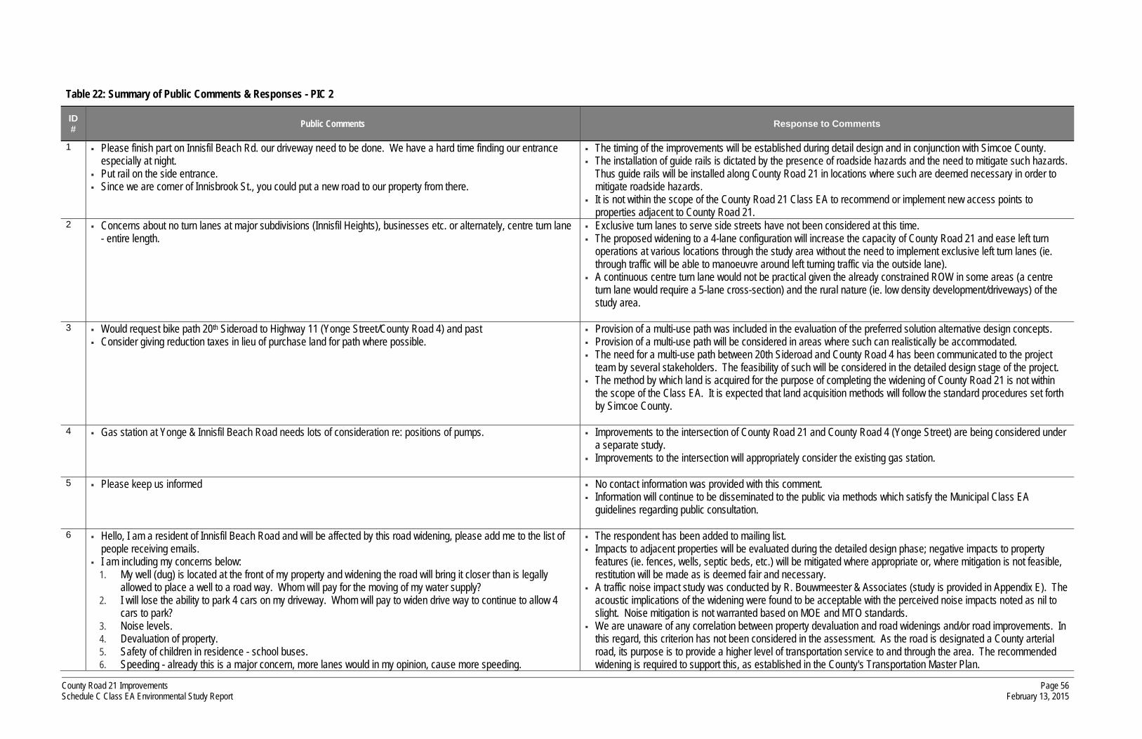
County Road 21 Improvements Schedule C Class EA Environmental Study Report
Page 56 February 13, 2015
Table 22: Summary of Public Comments & Responses - PIC 2
ID # Public Comments Response to Comments
1 Please finish part on Innisfil Beach Rd. our driveway need to be done. We have a hard time finding our entrance especially at night.
Put rail on the side entrance. Since we are corner of Innisbrook St., you could put a new road to our property from there.
The timing of the improvements will be established during detail design and in conjunction with Simcoe County. The installation of guide rails is dictated by the presence of roadside hazards and the need to mitigate such hazards.
Thus guide rails will be installed along County Road 21 in locations where such are deemed necessary in order to mitigate roadside hazards.
It is not within the scope of the County Road 21 Class EA to recommend or implement new access points to properties adjacent to County Road 21.
2 Concerns about no turn lanes at major subdivisions (Innisfil Heights), businesses etc. or alternately, centre turn lane - entire length.
Exclusive turn lanes to serve side streets have not been considered at this time. The proposed widening to a 4-lane configuration will increase the capacity of County Road 21 and ease left turn
operations at various locations through the study area without the need to implement exclusive left turn lanes (ie. through traffic will be able to manoeuvre around left turning traffic via the outside lane).
A continuous centre turn lane would not be practical given the already constrained ROW in some areas (a centre turn lane would require a 5-lane cross-section) and the rural nature (ie. low density development/driveways) of the study area.
3 Would request bike path 20th Sideroad to Highway 11 (Yonge Street/County Road 4) and past
Consider giving reduction taxes in lieu of purchase land for path where possible. Provision of a multi-use path was included in the evaluation of the preferred solution alternative design concepts. Provision of a multi-use path will be considered in areas where such can realistically be accommodated. The need for a multi-use path between 20th Sideroad and County Road 4 has been communicated to the project
team by several stakeholders. The feasibility of such will be considered in the detailed design stage of the project. The method by which land is acquired for the purpose of completing the widening of County Road 21 is not within
the scope of the Class EA. It is expected that land acquisition methods will follow the standard procedures set forth by Simcoe County.
4 Gas station at Yonge & Innisfil Beach Road needs lots of consideration re: positions of pumps. Improvements to the intersection of County Road 21 and County Road 4 (Yonge Street) are being considered under
a separate study. Improvements to the intersection will appropriately consider the existing gas station.
5 Please keep us informed No contact information was provided with this comment. Information will continue to be disseminated to the public via methods which satisfy the Municipal Class EA
guidelines regarding public consultation.
6 Hello, I am a resident of Innisfil Beach Road and will be affected by this road widening, please add me to the list of people receiving emails.
I am including my concerns below: 1. My well (dug) is located at the front of my property and widening the road will bring it closer than is legally
allowed to place a well to a road way. Whom will pay for the moving of my water supply? 2. I will lose the ability to park 4 cars on my driveway. Whom will pay to widen drive way to continue to allow 4
cars to park? 3. Noise levels. 4. Devaluation of property. 5. Safety of children in residence - school buses. 6. Speeding - already this is a major concern, more lanes would in my opinion, cause more speeding.
The respondent has been added to mailing list. Impacts to adjacent properties will be evaluated during the detailed design phase; negative impacts to property
features (ie. fences, wells, septic beds, etc.) will be mitigated where appropriate or, where mitigation is not feasible, restitution will be made as is deemed fair and necessary.
A traffic noise impact study was conducted by R. Bouwmeester & Associates (study is provided in Appendix E). The acoustic implications of the widening were found to be acceptable with the perceived noise impacts noted as nil to slight. Noise mitigation is not warranted based on MOE and MTO standards.
We are unaware of any correlation between property devaluation and road widenings and/or road improvements. In this regard, this criterion has not been considered in the assessment. As the road is designated a County arterial road, its purpose is to provide a higher level of transportation service to and through the area. The recommended widening is required to support this, as established in the County's Transportation Master Plan.

County Road 21 Improvements Schedule C Class EA Environmental Study Report
Page 57 February 13, 2015
ID # Public Comments Response to Comments
7. We have to wait in excess of 5 minutes to safely exit or enter our driveways with two lanes at certain times during the day, I fear 4 would only make this a longer wait. What can be done to make it easier for residents - lights, speed bumps, yield, turn lane.
Safety concerns regarding school bus operations should be addressed with the provider of such services and the respective school board. School bus operators have safety policies and procedures with respect to bus routes/stops on 4-lane roads.
Speeding is a law enforcement issue and thus concerns regarding speeding should be directed to the appropriate police authority.
A 4-lane cross section will provide additional capacity for through vehicles and will likely increase the number of gaps in the traffic flow, thus easing enter/exit movements.
7 We live on Innisfil Beach Road, west of Hwy. 11 on the south side, across from Eisses’s egg farm.
Our home is the log cabin close to the road and our septic system is in the front yard. Our neighbour to the west advised us of this project and his measurements indicated that if option G is used the
edge of the road would be at our front door! I would appreciate any information as to what stage we are at. Has a final decision been made on which option will
be used for the final design, timelines etc. A critical question is can accommodation be made for our situation?
Impacts to adjacent properties will be evaluated during the detailed design phase; negative impacts to property features (ie. fences, wells, septic beds, etc.) will be mitigated where appropriate or, where mitigation is not feasible, restitution will be made as is deemed fair and necessary.
The proposed 50 metre right-of-way in the vicinity of this property was extended from the adjacent section (where additional stormwater management is required) to maintain continuity. Upon further review, an urban cross section is more appropriate across the frontage of this parcel in order to avoid impacts to the existing residential house.
No final decision has been made at this point; additional consideration will be given during the detail design as to what measures are possible to avoid and/or mitigate any resulting impacts.

County Road 21 Improvements Schedule C Class EA Environmental Study Report
Page 58 February 13, 2015
13 Preferred Design
13.1 Preferred Design
The preferred design was confirmed following Public Information Centre 2, receipt and review of all public and review agency comments and in consideration of the environmental impact assessment of the preferred solution alternatives. The preferred design is summarized by road section in Table 23 and Figure 11.
Table 23: Preferred Design
Road Section
Length Preferred Design
Section 1 540 m Alternative G3 maintain existing ROW, implement urban cross section
Section 2 2,015 m Alternative G1 establish 40 metre ROW (50 metre ROW where SWM
features dictate), implement rural cross section
Section 3 1,560 m Intersection improvements - addressed under separate study
Section 4 425 m Alternative G3 maintain existing ROW, implement urban cross section
Section 5 800 m Alternative G3 maintain existing ROW, implement urban cross section
Section 6 950 m Intersection improvements - addressed under separate study
Section 7 2,430 m Alternative G1 establish 40 metre ROW (45/50 metre ROW where SWM features dictate), implement rural cross section
Section 8 980 m Intersection improvements - addressed under separate study
Section 9 280 m Alternative G1 establish 40 metre ROW, implement rural cross section
Section 10 320 m Alternative G3 maintain ROW to north and establish 30m ROW by
widening ROW to south (approximately 5m), implement urban cross section1
Section 11 1,330 m Alternative G1 establish 40 metre ROW (45/50 metre ROW where SWM
features dictate), implement rural cross section 1 Section 10 - existing ROW is too narrow to accommodate 4-lane cross section. Minor widening is required to
accommodate urban cross section.

County Road 21 Improvements Schedule C Class EA Environmental Study Report
Page 59 February 13, 2015
In select areas (18+460 to 18+500 north side across frontage of 2374 Innisfil Beach Road; 18+605 to 18+665 south side across frontage of 2341 Innisfil Beach Road), the proposed right-of-way widenings were revised to eliminate/reduce significant impacts to existing residences. Where this conflicts with the need for the additional stormwater management facilities, such will be relocated accordingly (ie. shifted upstream from the associated culvert). The resulting preliminary design drawings are provided in Appendix J. It is noted that these are considered preliminary and subject to further change through the detail design process.
13.2 Impact Mitigation
The Municipal Class EA guidelines recommend that significant features and impacts should be avoided where possible. However, where they cannot be avoided, every effort should be made to mitigate the adverse impacts. Manners in which impacts are to be mitigated, either in the development of the alternatives, or as part of the detail design and implementation, are noted below.
13.2.1 Stormwater Management
As previously noted, there are several water crossings along County Road 21 through the study area which require additional consideration in terms of stormwater management. Enhanced linear ditches are proposed at various locations to act as retention ponds to control the quantity of water and settling ponds to control the quality of the water. Otherwise, a typical roadside open ditch drainage system (as currently exists through the study area) will be employed for the road sections where the preferred solution is a rural cross section.
With respect to those areas where an urban cross section is preferred, the existing ditches will be replaced with curb, gutter and storm drains. Stormwater collected along these sections will be conveyed to the ditch system at the limits of the urban sections. Enhanced stormwater quality control for these sections will be provided (as deemed necessary) through the use oil/grit separators, or approved equal, at the downstream reach of the drainage system prior to discharging runoff to the existing outlets.
13.2.2 Impacts to Private Wells & Septic Systems
Impacts to private wells and septic systems located on adjacent properties will be evaluated during the detailed design phase of construction. Where such features are located within close proximity of the construction limits and the potential for negative impacts exists, all necessary mitigating measures will be applied. Relocation of such features will also be considered where appropriate.
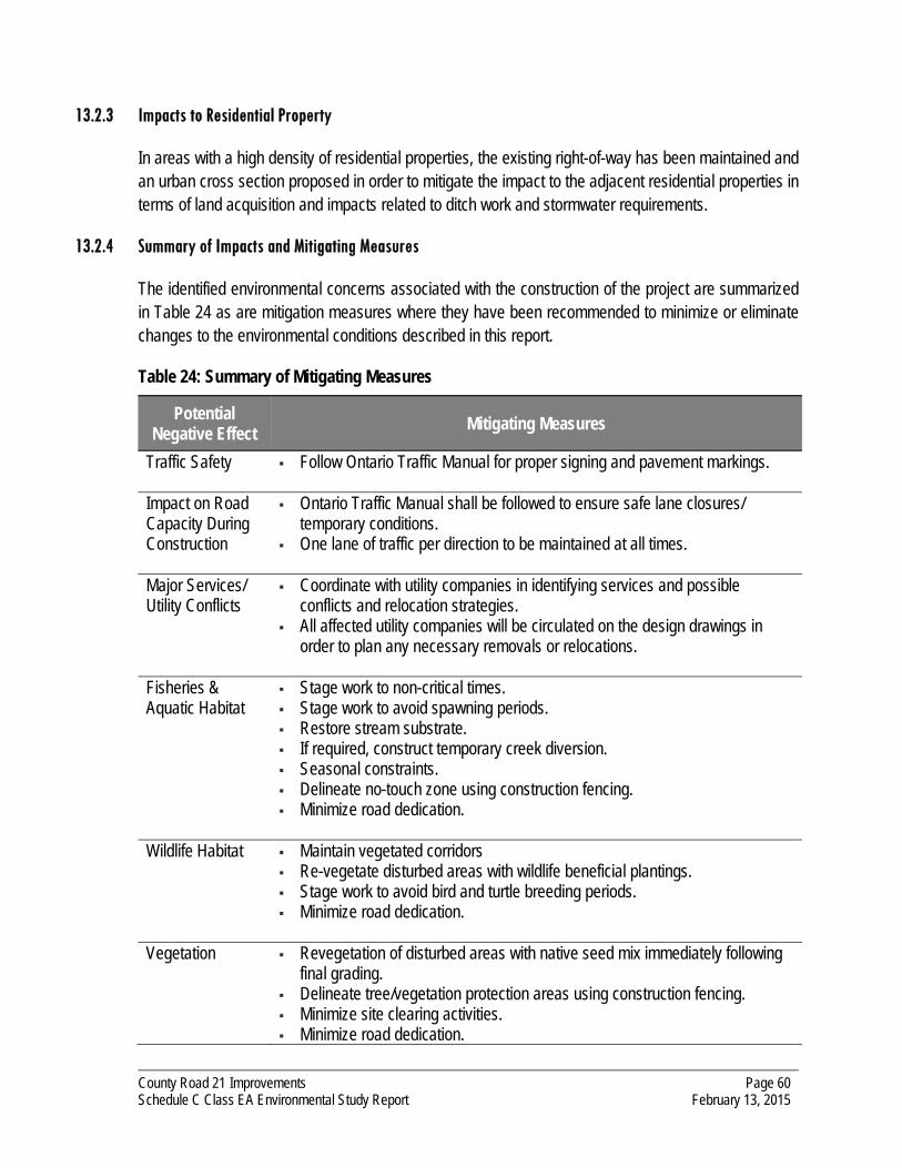
County Road 21 Improvements Schedule C Class EA Environmental Study Report
Page 60 February 13, 2015
13.2.3 Impacts to Residential Property
In areas with a high density of residential properties, the existing right-of-way has been maintained and an urban cross section proposed in order to mitigate the impact to the adjacent residential properties in terms of land acquisition and impacts related to ditch work and stormwater requirements.
13.2.4 Summary of Impacts and Mitigating Measures
The identified environmental concerns associated with the construction of the project are summarized in Table 24 as are mitigation measures where they have been recommended to minimize or eliminate changes to the environmental conditions described in this report.
Table 24: Summary of Mitigating Measures
Potential Negative Effect
Mitigating Measures
Traffic Safety Follow Ontario Traffic Manual for proper signing and pavement markings.
Impact on Road Capacity During Construction
Ontario Traffic Manual shall be followed to ensure safe lane closures/ temporary conditions.
One lane of traffic per direction to be maintained at all times.
Major Services/ Utility Conflicts
Coordinate with utility companies in identifying services and possible conflicts and relocation strategies.
All affected utility companies will be circulated on the design drawings in order to plan any necessary removals or relocations.
Fisheries & Aquatic Habitat
Stage work to non-critical times. Stage work to avoid spawning periods. Restore stream substrate. If required, construct temporary creek diversion. Seasonal constraints. Delineate no-touch zone using construction fencing. Minimize road dedication.
Wildlife Habitat Maintain vegetated corridors Re-vegetate disturbed areas with wildlife beneficial plantings. Stage work to avoid bird and turtle breeding periods. Minimize road dedication.
Vegetation Revegetation of disturbed areas with native seed mix immediately following final grading.
Delineate tree/vegetation protection areas using construction fencing. Minimize site clearing activities. Minimize road dedication.

County Road 21 Improvements Schedule C Class EA Environmental Study Report
Page 61 February 13, 2015
Potential Negative Effect
Mitigating Measures
Groundwater Resources
Delineate and properly prepare refuelling areas to prevent soil contamination due to fuel spills.
Identify and protect groundwater upwelling/source areas from contamination and flow disturbance.
Creek crossings must be designed to minimize disruption of the discharge features of the banks.
Water Quality/ Stormwater Management
Provision for spill control in construction contract. Fast, accurate reporting of spill to Ministry of the Environment. Pollution prevention and source control by best management land use
practices and best management stormwater practices. Equipment maintenance and refuelling away from watercourses. Temporary stockpiling of materials away from watercourses. Implementation of erosion and sedimentation controls and regular monitoring
and reporting of maintenance after every major rainfall event. Revegetation of disturbed areas immediately following final grading. Development of a stormwater quality management plan to minimize entry of
contaminants into the watercourse.
Archaeological/ Cultural Heritage Resources
The Stage I & II archaeological studies did not identify any areas of concern If archaeological or cultural heritage features are encountered during
construction, work will cease immediately and the Ministry of Tourism & Culture is to be contacted at (416) 212-0644 or toll-free at (866) 454-0049.
Impact on Existing Residents & Businesses
Notify public agencies and adjacent owners of construction scheduling. Ensure access is maintained as well as garbage, recycling and green bin
pickup.
Nuisance Concerns (Dust/Noise)
Dust levels monitored and road watering/sweeping completed as necessary. Construction limited to typical work hours (ie. 7:00AM to 7:00PM).
13.3 Monitoring
Monitoring objectives include:
monitoring of individual measures and issues (ie. erosion and sedimentation control, traffic control, waste management, etc);
monitoring of overall effectiveness of control measures; and
ongoing identification of areas of potential concern.

County Road 21 Improvements Schedule C Class EA Environmental Study Report
Page 62 February 13, 2015
Construction inspection will occur on a regular basis to ensure that the mitigation measures described in this report and in the subsequent contract document provisions are carried out effectively. The timing and frequency of these visits will coincide with the schedule of the construction operations and will be adjusted to reflect the sensitivity of site concerns and the development of unforeseen environmental problems during and after construction. The construction inspectors will maintain daily records which will detail any concerns, corrective actions and further actions required.
During short-term and long-term intervals of construction activity, the project site will be regularly monitored to ensure all environmental protection measures are operating effectively.
In addition to the site specific monitoring requirements, an audit of environmental performance for the project may be undertaken. Such an audit may include:
the review of long-term effectiveness of mitigation measures;
the review of inspection reports, notes and the resolution of noted concerns;
the review of comments and concerns received from regulatory agencies and public interest groups and how these issues were addressed; and
recommended modifications to mitigation measures or procedures as required.

County Road 21 Improvements Schedule C Class EA Environmental Study Report
Page 63 February 13, 2015
14 Completion of Municipal Class EA Process
This chapter details the steps remaining to complete the Schedule C Class Environmental Assessment process and to proceed to Phase 5: Implementation, which entails completion of the engineering drawings and construction.
14.1 Submission to Simcoe County
This Environmental Study Report was submitted to the Simcoe County and the preferred solution endorsed by County staff.
14.2 Stakeholder Consultation - Study Completion
This represents the third mandatory point of stakeholder consultation in the Schedule C Class EA process. The purpose of such is to identify the conclusion of the study and provide an opportunity for additional review of the study findings and recommendations within a 30-day review period.
In accordance with the EA guidelines, a Notice of Completion was prepared to identify the preferred improvement solution and the opportunity for further review (a copy of the notice is provided in Appendix K). The notice was distributed as follows:
mailed to each of the review agencies, municipality agencies and other stakeholder groups as previously contacted (posted February 13, 2015);
mailed to the area residents (posted February 13, 2015);
mailed to those in attendance at Public Information Centres 1 and 2 (posted February 13, 2015); and
advertised in the local newspapers on two separate occasions, in accordance with the Class EA guidelines.
14.3 30-Day Review Period
The Environmental Study Report will be placed on public record for a period of 30 days following the Notice of Completion. As per the notice, the public and review agencies will be encouraged to further review the report and provide written comments to the County.
If concerns arise regarding this study, which cannot be resolved in discussion with the County or the Project Team, the public can request that the Minister of the Environment make an order for the project to comply with Part II of the Environmental Assessment Act (referred to as a Part II Order), which addresses individual environmental assessments. Requests are to be submitted to the Minister, and copied to the County before the end of the 30-day review period.

County Road 21 Improvements Schedule C Class EA Environmental Study Report
Page 64 February 13, 2015
If there is no request for a Part II Order, the project may proceed based on the identified preferred improvements.
14.4 Implementation
It is the intent of the County to begin the tendering process for the road widening works prior to the 2017 construction period. As such, engineering drawings detailing the required works, including the need for mitigation measures to address impacts to the adjacent properties and environments will be provided.
Drawings will be submitted to the County and the conservation authorities as required, to obtain the necessary approvals prior to construction. There are no further requirements with respect to public consultation during Phase 5 (although meetings or coordination with affected landowners are likely to be required during the design process).
Authored by:
David Perks Transportation Planner
Reviewed by:
Michael Cullip, P.Eng. Director, Manager - Transportation & Municipal Engineering
© C.C. Tatham & Associates Ltd The information contained in this document is solely for the use of the Client identified on the cover sheet for the purpose for which it has been prepared and C.C. Tatham & Associates Ltd. undertakes no duty to or accepts any responsibility to any third party who may rely upon this document. This document may not be used for any purpose other than that provided in the contract between the Owner/Client and the Engineer nor may any section or element of this document be removed, reproduced, electronically stored or transmitted in any form without the express written consent of C.C. Tatham & Associates Ltd.

County Road 21 Class EA - Environmental Study Report Figure
PHASE 3PHASE 2 PHASE 4 PHASE 5PHASE 1
2. Discretionary public consultation to review problem or opportunity
Determine applicability of master plan approach
SelectSchedule
2. Inventory natural, social & economic
environment
3. Identify impact of alternative solutions
on the environment & mitigating measures
4. Evaluate alternative solutions: identify
recommended solutions
5. Consult review agencies & public re:
problem or opportunity & alternative solutions
6. Select preferred solution
Review & confirm choice of schedule
3. Identify impact of alternative designs on
environment & mitigating measures
4. Evaluate alternative designs: identify
recommended design
5. Consult reviewagencies & previously interested & directly
affected public
6. Select preferred design
Review environmental significance &
choice of schedule
7. Preliminaryfinalization of
preferred design
2. Environmental study report (ESR) placed on
public record
Notice of completionto review agencies
& public
Copy of notice of completion to MOE-EA
branch
3. Opportunity to request Minister within 30 days of notification to request an
order*
1. Complete contract drawings & tender
documents
2. Proceed to construction & operation
3. Monitor for environmentalprovisions &
commitments
IMPLEMENTATIONENVIRONMENTALSTUDY REPORT
ALTERNATIVE DESIGNCONCEPTS FOR
PREFERRED SOLUTION
ALTERNATIVESOLUTIONS
PROBLEM OROPPORTUNITY
Approved -may proceed
Order* granted, proceed
with individual
EA or abandon project
Notice of completion to review
agencies & public
ScheduleB
ScheduleC
Individual EA
Discretionary public
consultation to review preferred design
Order* granted, proceedas per
Minister’s direction or abandon project
Matterreferred
tomediation
ScheduleA / A+
Optionalformal mediation
Order*deniedwith orwithout
Minister’s conditions
*
Indicates possible events
Indicates mandatory events
Indicates probable events
Mandatory public contact points
Decision points on choice of schedule
Optional
Part II order
If no order*, may proceed
Opportunity for order* request to Ministerwithin 30days of
notification
1. Identify problemor opportunity
1. Identify alternative solution to problem or
opportunity
1. Identify alternative design concepts for preferred solution
2. Detail inventory of natural, social &
economic environment
1. Complete environmental study report
(ESR)
Municipal Class EA Process 1

County Road 21 Class EA - Environmental Study Report Figure
source: maps.simcoe.ca
STUDY AREA
Study Area 2
N

County Road 21 Class EA - Environmental Study Report Figure
7 - Looking west along County Rd. 21 from Innisbrook St.
4 - Looking east along County Rd. 21 towards Industrial Park Rd.
1 - Looking west along County Rd. 21 from commercial access
7 - Looking east along County Rd. 21 from Innisbrook St.
5 - Looking west along County Rd. 21 from Innisfil Heights Cr.
1 - Looking east along County Rd. 21 from commercial access
8 - Lover’s Creek water crossing
5 - Looking east along County Rd. 21 from Innisfil Heights Cr.
2 - Looking west along County Rd. 21 from Camilla Cr.
9 - Looking west along County Rd. 21 towards Town Hall
6 - Looking west along County Rd. 21 from Property 3133
2 - Looking east along County Rd. 21 from Camilla Cr.
10 - Typical property and utility constraints
6 - Looking east along County Rd. 21 from Property 3133
3 - Natural gas sub-station on north side of County Rd. 21
Existing Conditions 3
1 2 3 4 5 6 7 8 9 10

County Road 21 Class EA - Environmental Study Report Figure
Simcoe County Transportation System (Official Plan) 4
N
STUDY AREA
source: County of Simcoe Official Plan

County Road 21 Class EA - Environmental Study Report Figure
Aerial Photos & Road Section Details - County Road 27 to 5th Sideroad 5aC
amilla C
rescent
25.5m 28m 26m
Right-of-Way (as per Simcoe County) 0 20 40 60 80 100m
26m
26m
26m
26m
26m
26m
130 m50 km/h
2735 m80 km/h
160 m50 km/h
2735 m80 km/h
2735 m80 km/h
2735 m80 km/h
460 m80 km/h
33m 33m
Culvert 1
Water crossing
Culvert 2
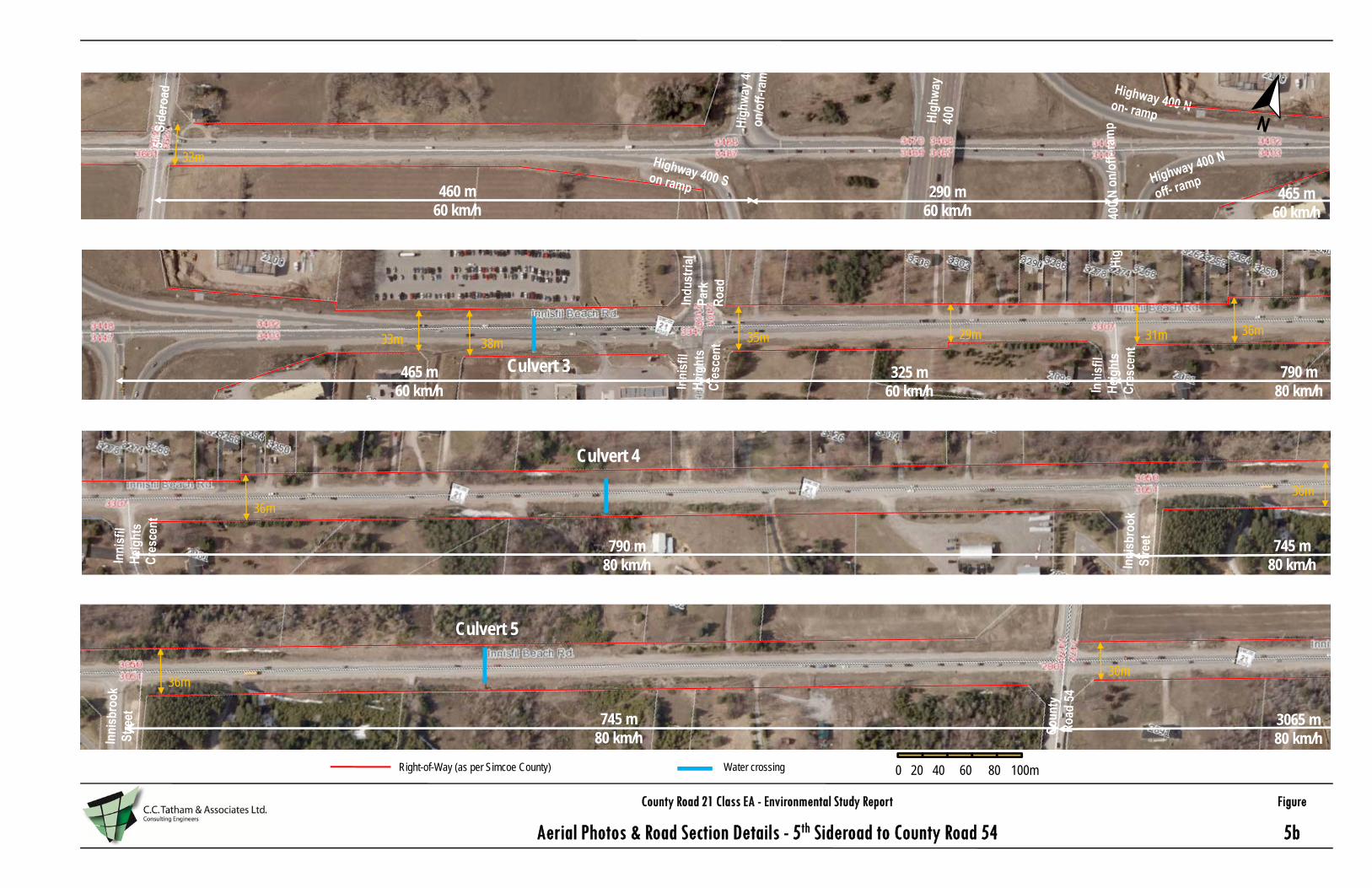
County Road 21 Class EA - Environmental Study Report Figure
Aerial Photos & Road Section Details - 5th Sideroad to County Road 54 5b
Right-of-Way (as per Simcoe County) 0 20 40 60 80 100m
38m33m
33m
29m35m 31m 36m
36m
460 m60 km/h
290 m60 km/h
465 m60 km/h
790 m80 km/h
325 m60 km/h
36m
36m
790 m80 km/h
745 m80 km/h
745 m80 km/h
3065 m80 km/h
30m
465 m60 km/h
Culvert 3
Culvert 4
Culvert 5
Water crossing

County Road 21 Class EA - Environmental Study Report Figure
Aerial Photos & Road Section Details - County Road 54 to County Road 4 5c
Right-of-Way (as per Simcoe County) 0 20 40 60 80 100m
30m
30m
30m
30m
30m
30m
30m
25m 30m25m 30m 28m 36m 33m 28m 33m
3065 m80 km/h
3065 m80 km/h
3065 m80 km/h
3065 m80 km/h
2980 m60 km/h
Culvert 6
Culvert 7
Culvert 8 Culvert 9
Water crossing

County Road 21 Class EA - Environmental Study Report Figure
Aerial Photos & Road Section Details - County Road 4 to County Road 39 5d
Right-of-Way (as per Simcoe County) 0 20 40 60 80 100m
33m 28m 33m 28m28m 28m31m
2980 m60 km/h
2980 m60 km/h
2980 m60 km/h
2980 m60 km/h
33m 31m
31m 28m 25m 28m 20m 28m
20m 28m 28m33m 28m
28m 36m 33m 28m
Culvert 10
Culvert 11
Water crossing

County Road 21 Class EA - Environmental Study Report Figure
Water Crossings 6a
N1
3-- water crossing west of Industrial Park Road, looking east on south side
3-- water crossing west of Industrial Park Road, looking southeast on north side
4-- water crossing east of property 3025 on the north side
4- water crossing east of property 3025 on the south side
2-water crossing west of 5th Sideroad, looking north
2- water crossing west of 5th Sideroad looking east on the north side
2- water crossing west of 5th Sideroad, on the north side looking west
2-water crossing west of 5th Sideroad, looking south
2- water crossing west of 5th Sideroad on the south side
2 3 4
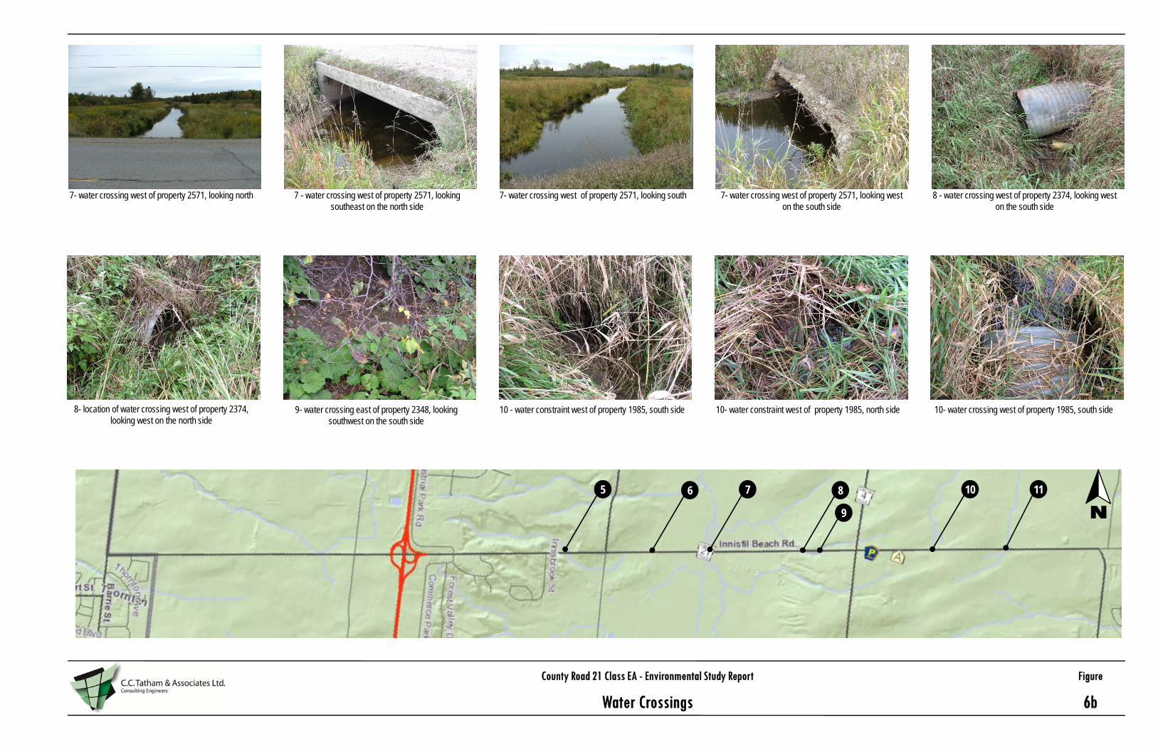
County Road 21 Class EA - Environmental Study Report Figure
Water Crossings 6b
N
7- water crossing west of property 2571, looking north
9- water crossing east of property 2348, looking southwest on the south side
7 - water crossing west of property 2571, looking southeast on the north side
10 - water constraint west of property 1985, south side
7- water crossing west of property 2571, looking south
10- water constraint west of property 1985, north side
7- water crossing west of property 2571, looking west on the south side
10- water crossing west of property 1985, south side
8 - water crossing west of property 2374, looking west on the south side
8- location of water crossing west of property 2374, looking west on the north side
7 8
9
105 6 11
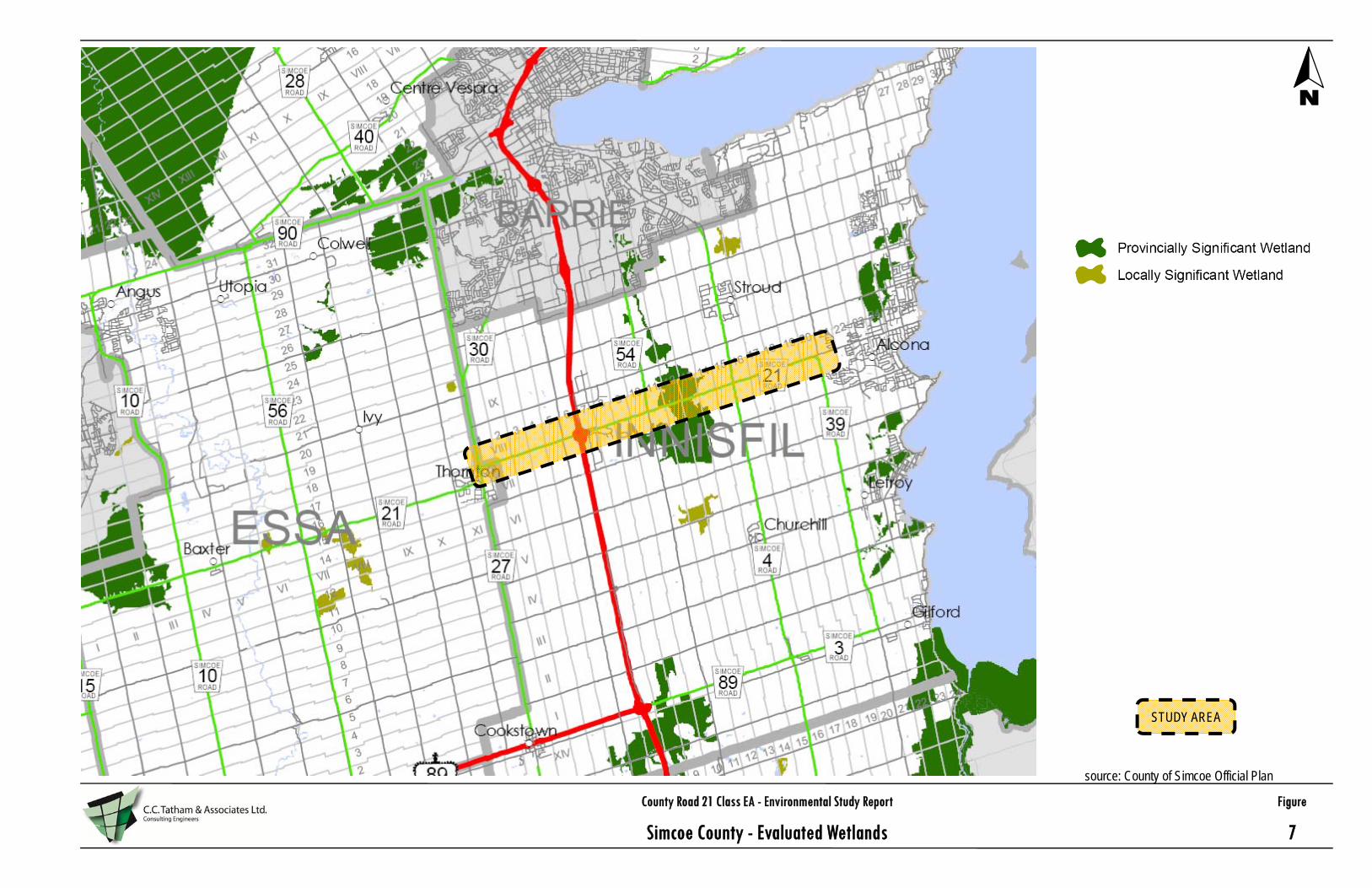
County Road 21 Class EA - Environmental Study Report Figure
Simcoe County - Evaluated Wetlands 7
N
STUDY AREA
source: County of Simcoe Official Plan

County Road 21 Class EA - Environmental Study Report Figure
Simcoe County - Land-use Designations 8
N
STUDY AREA
source: County of Simcoe Official Plan

County Road 21 Class EA - Environmental Study Report Figure
Preferred Solution - Alternative Design Concepts 9
Alternative Design G1: 40m ROW, 4-lane Rural Cross SectionAlternative Design G2: 36m ROW, 4-lane Rural Cross Section
Alternative Design G3: Maintain Existing ROW, 4-lane Urban Cross Section

County Road 21 Class EA - Environmental Study Report Figure
Stormwater Management Features - 50m ROW 10
Cross-Section with enhanced ditch for stormwater management control50m ROW (25m on either side)
Cross-Section with standard ditch40m ROW (20m on either side)

County Road 21 Class EA - Environmental Study Report Figure
Preferred Solution by Road Section 11
G3 G1 (SWM) N/A* G3 G3 N/A* G1 (SWM) N/A* G1 G3 G1 (SWM)
1 2 3 4 5 6 7 8 9 10 11
G1 - 40m ROW, 4-lane rural cross section G2 - 36m ROW, 4-lane rural cross sectionG3 - Maintain existing ROW, 4-lane urban cross section
(SWM) - 45/50m ROW required to accommodate SWM features
*N/A - intersection improvements covered under separate study

APPENDIX A:
TRAFFIC COUNTS

APPENDIX B:
NOTICE OF STUDY COMMENCEMENT

APPENDIX C:
NATURAL ENVIRONMENT INVENTORY REPORT

APPENDIX D:
ARCHAEOLOGICAL ASSESSMENT

APPENDIX E:
NOISE STUDY

APPENDIX F:
PUBLIC INFORMATION CENTRE 1

APPENDIX G:
STORMWATER MANAGEMENT DESIGN BRIEF

APPENDIX H:
NATURAL ENVIRONMENT IMPACT ASSESSMENT

APPENDIX I:
PUBLIC INFORMATION CENTRE 2

APPENDIX J:
PRELIMINARY DESIGN DRAWINGS

APPENDIX K:
NOTICE OF STUDY COMPLETION