scenic roadway plan cover - monmouth county, new jersey · monmouth county scenic roadway plan and...
TRANSCRIPT

THE MONMOUTH COUNTYSCENIC ROADWAY PLAN
Monmouth County Planning Board

Cover photo: Canopied road as viewed along Squankum-Yellowbrook Road (CountyRoute 524A) in Howell Township.

THE MONMOUTH COUNTYSCENIC ROADWAY PLAN
Prepared byMonmouth County Planning Board
1 East Main StreetFreehold, New Jersey 07728
Adopted by the Monmouth County Planning Board as an Element of theMonmouth County Growth Management Guide
September 17, 2001


MONMOUTH COUNTY SCENIC ROADWAY PLAN
TABLE OF CONTENTS
EXECUTIVE SUMMARY i
I. INTRODUCTION 1
II. DEVELOPMENT OF THE MONMOUTH COUNTY SCENIC 5ROADWAY PLAN
III. DESIGN GUIDELINES FOR MONMOUTH COUNTY’S 11SCENIC ROADWAYS
IV. SCENIC ROADWAY MANAGEMENT 33
APPENDICES 49
Appendix A Glossary of Rating Category Terminology 51
Appendix B Scenic Roadway Inventory and Rating System 71
Appendix C Research and Development: Preparation of Scenic Roadway 75Designation Criteria
Appendix D Monmouth County Planning Board Scenic Roadway 83Resolutions
BIBLIOGRAPHY 87
SCENIC ROADWAY PLAN MAP 95

i
EXECUTIVE SUMMARY
Monmouth County, New Jersey has long been known for its natural resources. To the
north, lie the colorful hills of deciduous forests with splendid views of the Raritan and
Sandy Hook Bays. To the east, lie the warm sandy beaches and bluffs that meet the
Atlantic Ocean. To the south, the hardwood forests of pine, spruce, and eastern red cedar
provide a shady canopy for the lush undergrowth of the forest floor. Finally, to the west,
lie the rolling fields of fertile agricultural land. Amid these natural resources lie the
history, culture, and people of Monmouth County and the miles of roadway that connect
the various towns and communities. These natural resources have been the mainstay for
attracting people to settle in this county for centuries. But what makes these natural
resources so desirable? The answer is its scenic beauty.
The scenic beauty of Monmouth County is evident as one drives, bicycles or walks down a
roadway and views the various landscapes composed of picturesque farmsteads, quaint
villages, panoramic views of distant towns and landscapes or as one witnesses the seasonal
changes of the landscape itself. It is the combination of both the composition of natural
and man-made elements within the landscape and the physical and mental reaction of
one’s senses to seeing those elements within the landscape, that makes a roadway scenic.
Scenic roadways not only contain physical resources worthy of preservation and
enhancement but they also contain visual resources that, when developed or erased from
existence, are not replaceable. In order for future generations of Monmouth County
residents to enjoy the scenic resources this county has to offer, a proactive approach to
planning and developing the land within or around these scenic resources needs to be
developed and implemented.
The Monmouth County Planning Board has prepared this Monmouth County Scenic
Roadway Plan to begin the stewardship towards a better and beautiful tomorrow. The

ii
purpose of the plan is to identify those county roadways, or sections of county roadways,
that possess such a high degree of visual quality that driving, biking or walking along these
roadways is a pleasurable and enjoyable experience. The primary goal of this plan is to
offer alternative design guidelines for roadways that are identified as “scenic” for use in the
Monmouth County Planning Board’s development review process and in the Monmouth
County Capital Improvement Program. This plan is designed to serve as a growth
management tool to guide the future development of land along scenic roadways and
resources within Monmouth County. It is developed not only for use by Monmouth
County in its review of development applications and capital improvement program but
also for all municipalities, design professionals and developers who shape the built
environment in which we live.
The Introduction discusses the major factors that lead to the development of the
Monmouth County Scenic Roadway Plan and the three principle goals that are to be
achieved through the implementation of this plan.
Chapter II, Development of the Monmouth County Scenic Roadway Plan, focuses on the
research and development of the county’s definition of a scenic roadway and the
methodology utilized to create the Scenic Roadway Inventory and Rating System. The
chapter further discusses the Rating Category Terminology that is used to define the
attributes contained on the inventory and rating system survey. A listing of the designated
Monmouth County Scenic Roadway is provided at the end of the chapter.
Chapter III, Design Guidelines for Monmouth County Scenic Roadway, describes the
design guidelines and the policies created to guide the future development of land along
Monmouth County’s Scenic Roadways. The guidelines are not only developed for use by
Monmouth County in its development review process but also for use in its Capital
Improvement Program.

iii
Ensuring that Monmouth County’s Scenic Roadways remain scenic requires the
coordination of the plan with other federal, state, local and non-profit organizations.
Chapter IV, Strategies for Scenic Roadway Management, discusses the changes that
municipalities and their professionals can make to Master Plans, Zoning and Development
Regulations. Emphasis is placed on the site design and landscape improvement guidelines
as these design components form the framework of most scenic viewsheds. The
coordination with other programs is a crucial element to scenic roadway protection and
management.

iv
Figure 1. View of field and forest edge as seen from Route 33 in the Township of Howell.

1
I. INTRODUCTION
The need for a scenic roadway plan in Monmouth County can, in part, be attributed to
several factors. The first factor is the construction of several major roadways over the past
half-century in and around the county which has substantially improved inter-regional
access and mobility. With the completion of the New Jersey Turnpike in 1949, the
extension of the Garden State Parkway through Monmouth County in 1954 and the
announcement by the Federal government to begin construction of the Interstate Highway
System in 1956, Monmouth County was soon discovered as a region rich in development
potential. The county suddenly appeared to be within reasonable driving distance from
the employment centers of northern New Jersey and New York. As a result, a building
boom began to emerge in early 1960’s. New homes and shopping centers began to take the
place of farms, wooded lands and open fields. The extension of US I-195 and Route 18
through the county in the 1970’s further increased inter-regional access and mobility,
spurring additional growth and development. By the 1980’s, the building boom was in full
swing adding thousands of new housing units as well as millions of square feet of
commercial, office and industrial buildings to Monmouth County which brought jobs
closer to home for the county’s growing population. This new development has, however,
contributed to the diminishment and loss of many of our scenic resources. With careful
management, a balance between economic growth and the preservation of the natural and
man-made historic, cultural and recreational features that compose our scenic resources is
attainable.
Another factor that has influenced the need for a scenic roadway plan, is the significant
public awareness placed forth by several well-organized environmental groups and
numerous progressive municipal governments of the county’s natural environment,
historical structures and cultural heritage. The Monmouth County Growth Management Guide
– Goals, Objectives and Policies (adopted December 1995), which serves as the master plan
for the county, has as one of its main goals, the need for the preservation of “…the valuable

2
historic, cultural, natural and scenic resources of Monmouth County.” The Growth
Management Guide supports the local efforts of municipal agencies and public/private
organizations to preserve scenic corridors and vistas throughout Monmouth County.
The State Development and Redevelopment Plan (SDRP, adopted in 1992 by the New Jersey
State Planning Commission), is another document that has influenced the county’s
decision to prepare a scenic roadway plan. One of the main goals of The State Development
and Redevelopment Plan is to “…preserve and enhance historic, cultural, open space and
recreational lands and structures.” The State Plan recognizes that the state’s varying
“…topographical features and historic and cultural landmarks, including urban skylines,
provide a scenic diversity that adds much to the quality of New Jersey life….” Because
poorly planned development may negatively impact the visual environment, the protection
and preservation of scenic corridors is included as a State Plan policy. The policy states:
“Scenic corridors should be protected by appropriate means and preserved by using
easement purchase, transfer of development rights, fee simple purchase and other
innovative and effective mechanisms.”
Finally, various municipal agencies over the years have identified certain roadways as
“scenic corridors” or “ scenic roadways” in their master plans. The identification of scenic
roadways by municipal agencies is encouraging, but the actual methodology used to
identify the roadways as scenic varies from town to town. It is apparent that there is a need
to develop a standardized rating and identification system that could be transferable among
municipalities not only within Monmouth County but also throughout the state.
In an effort to preserve and enhance the scenic roadways and resources that exist within
Monmouth County, standardize the rating and identification methods for scenic roadways
within Monmouth County, mitigate the mounting pressure that development is taking on
the county’s scenic resources and address the goals of the Monmouth County Growth
Management Guide and State Development and Redevelopment Plan, the Monmouth County

3
Planning Board is undertaking this Scenic Roadway Plan. Three principle goals are
presented below and serve as the framework from which this plan will be implemented:
(1) To identify [and enhance] those county roadways, or sections of countyroadways, that possess such a high degree of visual quality that driving, biking, orwalking along those roadways is a pleasurable experience.
(2) To establish alternative design guidelines for scenic county roadways for useby Monmouth County in its development review process and capitalimprovement program (C.I.P.).
(3) To present other methods of preserving and enhancing scenic roadways thatcan be implemented by other counties, municipalities, developers and agencies.
Policy statements, contained throughout the plan, further define the strategies through
which the goals are to be achieved. The achievement of these three goals will ensure that
the natural and man-made historical, cultural and recreational resources that exist along
the scenic roadways within Monmouth County will exist for future generations to enjoy.

4
Figure 2. Panoramic view of Sandy Hook Bay as viewed from Ocean Boulevard (County Route 8) in theBorough of Atlantic Highlands.

5
II. DEVELOPMENT OF THE MONMOUTH COUNTYSCENIC ROADWAY PLAN
Methodology
Preparation of the Monmouth County Scenic Roadway Plan began with the research and
review of information published by federal, state and local governments and non-profit
groups that have either implemented scenic roadway programs or have addressed issues
related to the preservation of scenic corridors, byways and roadways. While much of this
research is documented in the Appendix C, it is important to note that there is a wide
range among the various programs in scenic roadway identification, administration and
implementation criteria. Many of the programs researched used a process based on an
inventory of landscape elements present along the roadway. Features such as topography,
water, vegetation, wildlife, architecture, and cultural resources all play a vital role in the
scenic roadway designation process due to the ability of the features to evoke different
emotions when viewed from different vantage points, whether moving or stationary. Other
programs simply identified a roadway as scenic without any type of subjective rating
criteria.
Although the stated reasons for implementing a scenic roadway program and methodology
varied with each program researched, all of the programs had one common element: a
scenic roadway program provides the opportunity to be proactive in determining the fate of
the natural and man-made environment surrounding the roadway.
Other worthy benefits in implementing a scenic roadway program were found during
research. The designation of scenic roadways may generate tourism and, as a result, a
contribution to the local economy. The designation of scenic roadways also generates civic
pride and a sense of identity for a municipality or region because of unique elements that
may be located along the scenic roadway.

6
Defining A Scenic Roadway
In reviewing the various scenic roadway programs, there are several elements that were
commonly discussed in each scenic roadway definition that describe the characteristics of a
scenic roadway. The elements are:
1. All scenic roadways are used by various modes of transportation (automobile,pedestrian, bicycle, horseback, etc.).
2. All scenic roadways traverse through an environment composed of multiple elements(natural, man-made, historical, cultural, recreational, views, topography, etc.).
3. The environment surrounding all scenic roadways is ever-changing due to the terrain,elevation, and the proximity of natural and man-made elements from the roadwayedge.
4. The environment through which a person travels affects both their visual andpsychological perceptions and impressions.
When combined together as one definition, these four elements clearly define the
composition of a scenic roadway. As a result, a Monmouth County Scenic Roadway is
defined as follows:
Scenic Roadway: A public thoroughfare for the passage of vehicles, persons, or animals whichtraverses through an ever-changing, aesthetically pleasing environment that consists of naturaland man-made elements which stimulate the senses and leave a lasting impression on themind.
This definition provides the foundation on which the Monmouth County Scenic Roadway
Program is based.
Development of Scenic Roadway Inventory and Rating System
The scenic roadways of Monmouth County were identified using a comprehensive
inventory of positive and negative attributes, natural and man-made, that were visible from
the roadway. Positive attributes included such features as canopied roadways, dune
vegetation, panoramic views and historic structures. Negative attributes included such
features as severe erosion, overhead utility lines and corridors, dilapidated structures and
development that appears out of context with surrounding area. A complete description of

7
the Rating Category Terminology has been assembled in a glossary located in Appendix A
of this report.
The process of rating the scenic roadways involved driving all roadways within the
Monmouth County Roadway System1, conducting a ‘windshield’ inventory of the
attributes present along each half-mile segment of roadway, and rating the value of each
attribute based on its quality and cohesiveness to the roadway. The ratings were then
added together to obtain the total composite scenic roadway score, with the highest-rated
roadways identified as scenic. Based on the results of the survey process, the Scenic
Roadways of Monmouth County are listed in Table 1. All scenic roadways listed in Table
1 are listed by segment according to local route name and the nearest mile-mark as defined
within the Monmouth County Roadways Straight Line Diagram manual. A sample of the
Monmouth County Scenic Roadway Inventory and Rating System Survey is located in
Appendix B of this report.
Table 1The Scenic Roadways of Monmouth County
County Route # Local Route Name Municipality Milepost to Milepost Total mi.
Route 3 Main St. Manalapan 0 .8 .80Route 3 Tennent Rd. Manalapan .8 1.2 .40
Route 4 Crine Rd. Colts Neck 0 1.68 1.68Route 4 Conover Rd. Colts Neck 1.68 2.56 .88Route 4 South St. Colts Neck 2.56 3.2 .64Route 4 S. Holmdel Rd. Holmdel 3.2 3.75 .55Route 4 Holmdel Rd. Holmdel 3.75 7.8 4.05
Route 8 Ocean Blvd. Atlantic Highlands .45 2.75 2.30Route 8 Orchard Ave. Atlantic Highlands 2.75 2.83 .08
Route 8A Bingham Ave. Rumson 1.2 1.65 .45Route 8A Locust Point Rd. Middletown 1.65 2.6 .95Route 8A Locust Ave. Middletown 2.6 3.0 .40
1 The Monmouth County Roadway System is a network of existing and potential county roadways that act asa continuous thoroughfare for carrying traffic to and from major traffic generators such as shopping centers,hospitals, employment centers and transportation centers in a quick and efficient manner. In most cases, thesystem provides a link between municipal collector roadways and state and/or federal roadways.

8
County Route # Local Route Name Municipality Milepost to Milepost Total mi.
Route 8B Navesink Ave. Middletown 0 .98 .98
Route 12A Navesink River Rd. Middletown .9 4.54 3.64
Route 13A Sycamore Ave. Shrewsbury Borough 2.0 3.0 1.00
Route 18 Belmar Blvd. Howell 0 1.45 1.45Route 18 Belmar Blvd. Wall 1.45 2.0 .55Route 18 Ocean Ave. Spring Lake 9.2 11.15 1.95Route 18 Ocean Ave. Belmar 11.15 12.68 1.53Route 18 Ocean Ave. Avon-By-The-Sea 12.68 13.25 .57Route 18 Ocean Ave. Bradley Beach 13.25 14.18 .93Route 18 Ocean Ave. Bradley Beach 14.18 14.6 .42
Route 21 Southard Ave. Howell 0 .75 .75Route 21 Manassa Rd. Howell .75 1.55 .80Route 21 Old Tavern Rd. Howell 1.55 3.78 2.23Route 21 Allenwood Rd. Howell 3.78 4.1 .32Route 21 Squankum Rd. Wall 4.1 5.08 .98Route 21 Allenwood-Lakewood Rd. Wall 5.08 6.77 1.69
Route 27 Holmes Mill Rd. Upper Freehold 0 3.5 3.50Route 27 Burlington Path Upper Freehold 3.5 5.27 1.77Route 27 Arneytown-Hornerstown Rd. Upper Freehold 5.27 6.8 1.53Route 27 Main St. Upper Freehold 6.8 7.0 .20
Route 43 Imlaystown-Hightstown Rd. Upper Freehold 0 1.02 1.02Route 43 Davis Station Rd. Upper Freehold 1.02 1.15 .13Route 43 Imlaystown Rd. Upper Freehold 1.15 1.65 .50
Route 50 Church St. Middletown 6.5 6.7 .20Route 50 Kings Highway Middletown 6.7 6.9 .20Route 50 New Monmouth Rd. Middletown 6.9 7.0 .10
Route 53 Georgia Rd. Freehold Township 0 1.04 1.04
Route 54 Phalanx Rd. Colts Neck 0 2.74 2.74
Route 520 Newman Springs Rd. Marlboro 4.0 5.1 1.10Route 520 Newman Springs Rd. Colts Neck 5.1 6.6 1.50Route 520 Newman Springs Rd. Holmdel 6.6 9.25 2.65Route 520 Newman Springs Rd. Middletown 9.25 10.8 1.55Route 520 Rumson Rd. Little Silver 15.4 16.2 .80Route 520 Rumson Rd. Rumson 16.2 19.67 3.47
Route 522 Freehold Rd. Manalapan 2.95 4.35 1.40Route 522 Freehold-Englishtown Rd. Freehold Township 4.35 5.1 .75
Route 524 S. Main St. Allentown .85 1.45 .60Route 524 N. Main St. Allentown 1.45 1.9 .55Route 524 Old York Rd. Upper Freehold 1.9 2.5 .60

9
County Route # Local Route Name Municipality Milepost to Milepost Total mi.
Route 524 New Canton-Stone Tavern Rd. Upper Freehold 2.5 8.0 5.50Route 524 Stage Coach Rd. Millstone 8.0 14.65 6.65Route 524 Elton-Adelphia Rd. Freehold Township 14.65 16.65 2.00Route 524 Allaire Rd. Howell 26.5 27.25 .75Route 524 Atlantic Ave. Wall 27.25 29.5 2.25Route 524 Allaire Rd. Wall 30.1 32.0 1.90
Route 524A Squankum-Yellowbrook Rd. Howell 1.6 3.79 2.19
Route 524 Spur Atlantic Ave. Wall 0 .45 .45
Route 526 Waker St. Allentown .37 .75 .38Route 526 Allentown-Red Valley Rd. Upper Freehold .75 6.8 6.05Route 526 Trenton-Lakewood Rd. Millstone 6.8 8.0 1.20
Route 527 Smithburg Rd. Manalapan 2.85 4.85 2.00Route 527 Millhurst Rd. Manalapan 7.15 9.81 2.66
Route 527A Smithburg Rd. Manalapan 0 2.25 2.25Route 527A Iron Ore Rd. Manalapan 2.25 5.86 3.61
Route 537 Monmouth Rd. Millstone 9.35 13.8 4.45Route 537 Monmouth Rd. Freehold Township 13.8 16.0 2.20Route 537 Colts Neck Rd. Colts Neck 21.3 27.7 6.40Route 537 Tinton Ave. Tinton Falls 27.7 28.2 .50
Route 539 High St. Allentown 0 .25 .25Route 539 Allentown-Davis Station Rd. Upper Freehold .25 3.2 2.95Route 539 Forked River Rd. Upper Freehold 3.2 4.55 1.35Route 539 Old York Rd. Upper Freehold 6.86 8.78 1.92
Route 547 Lakewood-Farmingdale Rd. Howell 1.0 4.0 3.00
Route 549 Herbertsville Rd. Howell 0 1.75 1.75Route 549 Herbertsville Rd. Wall 1.75 3.08 1.33
Route 571 Perrineville Rd. Millstone 0 .6 .60Route 571 N. Rochdale Ave. Roosevelt .6 2.2 1.60Route 571 Clarksburg Rd. Roosevelt 2.2 2.9 .70Route 571 Rising Sun Tavern Rd. Millstone 2.9 4.46 1.56
Other Proposed Scenic County Roadways Not Currently in System
Allentown Bypass Upper FreeholdSharon Station Roadway Upper FreeholdHalls Mill Roadway Extension Freehold TownshipKozloski Roadway Extension Freehold Township
Total Mileage of Scenic Roadways 134.22 mi.Total Mileage of County Roadway System 380.92 mi.Percentage of Scenic Roadways in County Roadway System 35 %

10
Figure 3. Canopied roadway as viewed along Squankum-Yellowbrook Road (County Route 524A) in theTownship of Howell.

11
III. DESIGN GUIDELINES FOR MONMOUTH COUNTY’SSCENIC ROADWAYS
After a county roadway has been identified as scenic, it is important that measures be taken
to ensure that these roadways maintain their high degree of visual quality. The design
guidelines contained in this chapter will assist in the enhancement, protection and
maintenance of the county’s scenic roadways and resources. Without these design
guidelines in place, new development will continue to encroach upon the scenic roadway,
further altering the character of the environment that provides the sense of place for each
roadway within the county.
The goal of the scenic roadway design guidelines is to preserve, to the greatest extent
possible, the existing physical features of the scenic roadway. Improvements, where
necessary to meet public safety requirements, should be kept to the minimum standards
acceptable for the safety and convenience of the travelling public and should complement,
rather than intrude, into the surrounding landscape.
The Monmouth County Development Review Resolution sets forth the design standards for
physical improvements required of new development, including all minor subdivisions,
major subdivisions and site plans, located along a county roadway or that impact a county
drainage facility. The Resolution contains standards regulating such elements as: spacing of
new driveways, roadway design and alignment, curbing, right-of-way dedication and
stormwater management. The scenic roadway design guidelines contained in this chapter
are intended to serve as an alternative approach to the Development Review Resolution design
standards for Monmouth County. All landscaping existing within the right-of-way of a
scenic roadway is to be considered an integral part of the roadway environment and should
be included within the realm of roadway improvements as determined by the Monmouth
County Development Review Committee. By providing flexibility in the design process for
both the developer and development review committee, a concerted and cooperative effort
can be made to combine the functions and safety of roadway design with the aesthetics of

12
the surrounding scenic resources. Public health, safety, convenience and general welfare is
to be upheld – it is not the intent of these scenic roadway design guidelines to compromise
traffic safety or drainage requirements.
Application of the Scenic Roadway Design Guidelines
Any minor subdivision, major subdivision or site plan application submitted to the
Monmouth County Planning Board and that is located along a segment of county roadway
that has been identified as scenic, will be subject to review pursuant to the guidelines
contained in this chapter. Due to variations in local conditions, developers, or their
professionals, are encouraged to contact the Monmouth County Planning Board staff early
in the design stage for assistance in applying the scenic roadway design guidelines on a case-
by-case basis – pre-application conferences are strongly encouraged. The final project review and
approval rests with the Monmouth County Development Review Committee.
The coordination and application of the scenic roadway design guidelines to other
Monmouth County plans or programs including the Monmouth County Capital
Improvement Program (C.I.P.), will be evaluated on a case-by-case basis. Where the
application of the scenic roadway design guidelines is warranted, a pre-design phase
meeting will be conducted between the various departments and any hired consultants or
professionals to convey the goals of the scenic roadway program and to determine the
appropriate design guidelines to be applied to that project.
In order to implement the scenic roadway concept, the Monmouth County Development
Review Committee may waive the installation of certain standard road and drainage
improvements required by the Monmouth County Development Review Resolution for
projects abutting a scenic county roadway, and may require the installation of certain
scenic roadway enhancements as described in the Section, “Monmouth County Scenic
Roadway Design Guidelines.” Prior to Final Approval, the applicant/developer will be
13
required to submit a payment in-lieu-of installing any standard improvements waived by
the Monmouth County Development Review Committee, less the value of any scenic
roadway improvements. The county may use this money to install road or drainage
improvements if such improvements are determined to be necessary in the future and may
also use this money to enhance landscaping along identified scenic roadways located off-
site.
Calculation of Payment In-Lieu-Of Improvements by Applicant/Developer
Value of Standard Road and Drainage Improvements required by theMonmouth County Development Review Resolution
- Value of Scenic Roadway Improvements required by the MonmouthCounty Development Review Committee
= Payment In-Lieu-Of Improvement
Monmouth County Scenic Roadway Design Guidelines
Scenic Roadway Policy 1:Encourage the use of the Monmouth County Scenic Roadway Design Guidelines in thesite design process, in the development review process and in the Monmouth CountyCapital Improvement Program.
The following guidelines may be applied to county roadways or segments of county
roadways that have been identified as scenic and that are listed in Table 1 of this report:
Cartway
Along a scenic roadway, the cartway width may be reduced from the standard 40.0’to a minimum of 36.0’. The roadway half-width pavement section should include a12.0’ traveled way and a 6.0’ shoulder. Additional pavement widening may benecessary where left turn lanes or acceleration/deceleration lanes are required.
For all proposed roadway improvements, the minimum acceptable lane widthshould be 12.0’. The application of shoulders should be evaluated on a case-by-casebasis. Public heath, safety, convenience and general welfare is to be upheld.

14
Where a scenic roadway is to be designated as a bicycle route, the minimumshoulder width should be 6.0’ and should be clearly signed or striped identifyingthe joint usage of the roadway.
Roadway Alignment
New roadways proposed through scenic terrain or with views to a scenic viewshedshould be designed to follow existing contours, promote views to prominent scenicresources and strive to preserve natural features to the greatest extent possible whileproviding for the minimum standards acceptable for the safety and convenience ofthe travelling public.
Any proposed realignment or reconstruction to a scenic roadway to accommodateprojected traffic conditions should be evaluated on a case-by-case basis. Carefulattention should be paid to the nature of the existing landscaping, scenic resourcesand roadway alignment and, where applicable, be incorporated into the newalignment or construction.
Right-of-Way
The Monmouth County Development Review Resolution requirement ofadditional right-of-way dedication consistent with the Monmouth County RoadwayPlan remains in effect.
Any existing landscaping1 that is growing within the right-of-way of a scenicroadway, is determined to be of healthy growing condition and considered an assetto the scenic roadway, should be evaluated for any impacts to traffic safety or sightdistance.
Any landmark tree2 that exists within the right-of-way of a scenic roadway, shouldbe preserved to the greatest extent possible.
Any landscaping (including a landmark tree) that is located within the right-of-wayof a scenic roadway and that is determined to create a traffic safety or sight distanceconcern because of overgrowth, should have selective clearing or trimmingundertaken to resolve the problem.
Any landscaping (excluding a landmark tree) that is located within the right-of-wayof a scenic roadway and prohibits the view to a scenic viewshed, should beselectively cleared or trimmed to promote the view.
1 Landscaping shall be considered as any tree, shrub, perennial, biennial, annual or groundcover.2 Landmark Tree shall be considered as any tree growing within the right-of-way of a scenic roadway thatis listed on a state, county or municipal historic, heritage or big trees list, exhibits an unusual quality, is ofspecies rareness or has a direct relation to an historic event, person or structure within Monmouth County.

15
Any landmark tree that is located within the right-of-way of a scenic roadway andprohibits the view to a scenic viewshed, should be evaluated for selective clearing ortrimming on a case-by-case basis.
Any hardscape element, such as a fence, wall or decorative paving treatment andthat is located within the right-of-way of a scenic roadway, should be evaluated forpossible preservation. Where existing hardscape elements within the right-of-waycreate a traffic safety or sight distance concern, the hardscape element should eitherbe moved back to behind the right-of-way line or removed entirely.Any scenic resource located outside the right-of-way within the scenic viewshed isconsidered an integral part of the scenic viewshed for that roadway and should beevaluated for possible preservation through the use of creative land use controls orother programs.
Intersections and Driveways
Due to the great variation found in actual on-site conditions, the intersection ofnew roadways with scenic roadways must be reviewed on a case-by-case basis. Itemssuch as dedicated turn lanes, acceleration and deceleration lanes and pavementwidening may be required due to existing and projected traffic conditions.
The use of channelized islands and curbed islands along scenic roadways should beevaluated on a case-by-case basis for applicability. Where channelized islands andcurbed islands are required, mountable curbs are encouraged. The use ofalternative paving materials for the surface area within the channelized island orcurbed island is encouraged.
The number of curb-cuts along scenic roadways should be reduced to avoidpotential traffic conflicts. Where applicable, the use of reverse frontage shall beutilized. Multiple driveway access points should be avoided in order to reducepotential traffic conflicts and to reduce the visual and physical impact on the scenicroadway. The use of a shared access driveway along a scenic roadway may bepermitted where its application is warranted.
Curbs
Curbing, as typically required along a county roadway, is discouraged from usealong scenic roadways except where required at intersections, radii points, drivewayingress and egress points, medians, drainage inlets or bridges, steep slopes and areaswhere high erosion potential exists. Instead, natural surface drainage from aroadway or hardscape surface should be utilized in combination with swales inorder to promote groundwater recharge.

16
Sidewalks
The construction of sidewalks along a county roadway is not a requirement of thecounty but one of municipal jurisdiction. Where sidewalks are necessary withinscenic urban/suburban areas, the use of alternative construction materials shouldbe considered. Alternative materials for sidewalk construction may include, butnot be limited to: stamped concrete, brick paver, concrete paver, aggregateconcrete, asphalt or bluestone. Where a sidewalk is necessary within scenic ruralareas, rubberized surface material, quarry dust or crushed stone may also be used.The use of white concrete for sidewalks is discouraged along scenic roadways.Sidewalks may be required along a scenic roadway where the need for safepedestrian travel is warranted or where a sidewalk will provide a connectionbetween two existing unconnected segments of sidewalk.
All existing sidewalks located within the right-of-way of a scenic roadway, that areconstructed of materials other than concrete and are determined to be integralparts of the scenic environment through which they traverse, should be enhanced,preserved and maintained to the greatest extent possible. Where a sidewalk locatedwithin the right-of-way creates a hazard to pedestrians or does not meet acceptableAmericans with Disabilities Act (ADA) requirements, the sidewalk should either berepaired or replaced with material of equal or greater quality provided the characterof the area is not altered significantly.
Figure 4. The reconstruction of the County Bridge S-13 spanning Pine Brook located on TintonAvenue (Route 537) bridge in the Borough of Tinton Falls included providing a separate bridge forpedestrians. As a result, safety and aesthetics were blended together in the design.

17
Where a bridge construction or reconstruction project is to occur along a scenicroadway, provisions should be made to install a sidewalk on one side of the bridgeas a minimum. The application of sidewalks on both sides of the bridge should bedetermined on a case-by-case basis (See Figure 4 previous page).
All sidewalks should maintain a minimum clear width of 4.0’ and meet or exceedADA requirements.
Bicycle Facilities
The construction of bicycle facilities along a county roadway is not a requirementof the county but one of municipal jurisdiction. A bicycle facility may be requiredalong a scenic roadway where the need for safe bicycle travel is warranted or wherea bicycle facility will provide a connection between two existing unconnectedsegments of bicycle facility.
Where a bicycle facility is to be installed within the right-of-way, it is encouragedthat the bicycle facility be grade separated from the roadway in order to reduce thepotential for bicycle/auto conflicts.
Where a bicycle facility is to be installed within the right-of-way, the use ofalternative construction materials should be considered. Alternative materials forbicycle facility construction may include, but not be limited to: rubberized surfacematerial, quarry dust or fine crushed stone. The use of white concrete for bicyclefacility construction is discouraged along scenic roadways.
All existing bicycle facilities located within the right-of-way of a scenic roadway, thatare constructed of materials other than concrete and are determined to be integralparts of the scenic environment through which they traverse, should be enhanced,preserved and maintained to the greatest extent possible. Where a bicycle facilitylocated within the right-of-way creates a hazard to bicyclists or does not meetacceptable bicycle facility requirements, the bicycle facility should either be repairedor replaced with material of equal or greater quality provided the character of thearea is not altered significantly.
Where a scenic roadway is to be designated as a bicycle route, the minimumshoulder width should be 6.0’ and should be clearly signed or stripped identifyingthe joint usage of the roadway.
Where a bridge construction or reconstruction project is to occur along a scenicroadway, provisions should be made to provide adequate lane or shoulder widthacross the bridge for the safe passage of bicycles on one or both sides of the bridge.

18
All bicycle facilities should conform to the guidelines as specified in the NJDOTBicycle Compatible Roadways and Bikeways Manual and should meet or exceed ADArequirements.
Drainage
Wherever possible, catch basins, drain inlets, and trench drains should be installedat-grade without curbheads to provide accessibility and safety. Bicycle-safe gratesshould be installed along all scenic roadways.In order to maintain rural character along some scenic roadways, parabolic swalesare encouraged to be installed. Determination of appropriate engineeringtechnique and/or application will be made on a case-by-case basis. The purpose ofthe swales is to capture and channel runoff from paved surfaces where there issufficient right-of-way and where soil and topography conditions are more favorableto its application. Swales should utilize the natural contour of the land whereapplicable, to aid in the drainage of water from roadway surfaces and topography.
The foreslope of all parabolic swales should not exceed 4:1; where the foreslopeexceeds 4:1, a guiderail or barrier will be required. The backslope of all parabolicswales should not exceed 2:1 for ease of motorized maintenance operations; wherebackslopes exceed 2:1, alternate slope stabilization methods should be implemented(See Figure 5 below).
Figure 5. Where conditions permit, the installation of parabolic swales in lieu of curbs can helpbeautify the side of a roadway while still maintaining drainage requirements as seen in this examplealong a residential street.

19
Where feasible, all detention and retention basins should be designed using thenatural contours of the landscape and should appear as naturally formed elementsof the environment rather than as an engineered structure.
The top of all headwalls should not extend more than 6” vertically from theexisting or proposed grade and should be sited so that no visual intrusion orphysical obstruction occurs within a scenic viewshed. This guideline does not applywhere pedestrian and/or bicycle barriers are to be installed.
Grading and Clearing
Except to provide proper sight distance from a new driveway or new roadway,existing vegetation should be retained along a scenic roadway. The grading andclearing of the full width of the right-of-way, as typically required, should beavoided. However, any object determined to be fixed object hazard should beremoved and/or relocated to a minimum distance of 6.0’ from the edge ofpavement.
Where clearing and grading of the right-of-way is necessary, the existing vegetativepattern should be cataloged by the developer for future re-establishment after finalgrade has been established. The catalog should include: botanical name, commonname and caliper or size of plant to be removed.
Any required grading of the right-of-way should be rounded back into the existinggrade; excessive cut and fill slopes should be avoided.
Any steep slope (4:1 or greater) requiring slope stabilization should be stabilizedwith geo-textile materials, jute mesh, or approved equal and, where applicable, belandscaped with native plant species to re-establish the vegetative patterns existingalong the roadway. The use of rip-rap stone or similar product may be utilizedwhere conditions warrant its application. The use of form-lined pre-cast concrete,decorative concrete block or timber retaining wall materials may be utilized whereconditions warrant and where appropriate safety treatments can be implemented.
Selective clearing of vegetation within the right-of-way is permitted for traffic safetyand sight distance concerns and to provide access to a scenic view or focal point.Where selective clearing is proposed, a set of plans delineating the course of actionshould be submitted to the county for review and comment.
Guiderails and Barriers
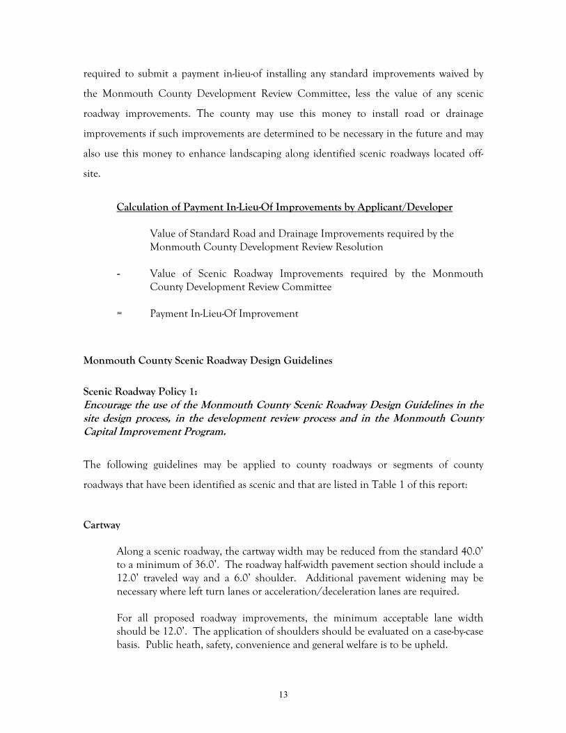
Where the use of guiderails is necessary along a scenic roadway, brown, epoxy-coated guiderails should be installed to minimize the visual impacts of the guiderailon the adjacent scenic resources (See Figure 6 on the following page).
20
Figure 6. Brown, epoxy-coated steel guiderails such as this one installed on County Bridge F-55spanning Lake Topanemus located on Pond Road in Freehold Township, helped blend the bridgeinto the landscape, thus making it less obtrusive in the viewshed.
To minimize the clearing needed along a scenic roadway, guiderails should beinstalled at the minimum offset that safety standards permit. However, a minimumclearance of 12” should be provided from the edge of pavement to the face of theguiderail.
Where concrete barriers are to be constructed as part of a bridge located along ascenic roadway, consideration should be given to providing architectural treatmentsuch as stone masonry or stone veneer, so as to minimize the visual impact thebarrier will have on the scenic resources. Stone masonry or stone veneer is notpermitted for use on a center barrier median.
Bridges and Culverts
Any existing bridge or culvert located along a scenic roadway that possesseshistorical significance or an unique method of construction or material, should beinvestigated for potential preservation, enhancement and/or retention of the visualand physical characteristics of the bridge or culvert and evaluated for its value tothe scenic roadway, wherever possible.
Where an existing bridge, located along a scenic roadway, possesses historicalsignificance or an unique method of construction or material and that has been

21
determined to be replaced but is of sound structural condition, an effort should bemade to find a suitable adaptive reuse for the bridge.
New bridges or existing bridges proposed for reconstruction, should be designed topermit viewing of scenic resources. Where applicable, a minimum 5.0’ widesidewalk should be provided in addition to the shoulder and the travel lanes. Theexterior bridge treatment should be designed to contextually reflect thearchitectural or thematic character of the surrounding area (See Figure 7 below).
Figure 7. Careful historic reconstruction of County Bridge O-21 spanning Lake Takanassee locatedalong Ocean Avenue in Long Branch enabled this scenic view to be maintained while preserving theintegrity of the original design.
All visible portions of proposed culverts should be designed to contextually fit intothe landscape. Stone masonry or stone veneer concrete construction is encouragedin areas of the county where structures of that type and materials are prevalent.The top of all culvert headwalls should not extend more than 6” vertically from anyexisting or proposed grade and should be sited so that no visual intrusion orphysical obstruction occurs within a scenic viewshed. This guideline does not applywhere pedestrian and/or bicycle barriers are to be installed.
All culverts requiring slope stabilization should be constructed of either geo-textilematerial, jute mesh, or approved equal and, where applicable, be landscaped. Theuse of rip-rap stone or similar product may be utilized where conditions warrant itsapplication. The use of form-lined pre-cast concrete, decorative concrete block ortimber retaining wall materials may be utilized where conditions warrant and whereappropriate safety treatments can be implemented.

22
All culverts should be appropriately landscaped or screened to prevent visualintrusion or physical obstruction within a scenic viewshed unless it has beendesigned to appear as an existing landscape element within the scenic viewshed.
Detention/Retention Basins
Where site conditions permit, it is encouraged that all detention/retention basinsbe located outside of a scenic viewshed area, preferably toward the rear of site, andwhere applicable, be screened with landscape plants in order to minimize the visualimpact on the scenic viewshed.
As a result of installing swales on the right side of this residential subdivision entrance roadway(Figure 8 above), the developer was able to eliminate an earlier proposal for a detension basin on theleft side of the roadway (Figure 9 below) which would have been located within the scenic viewshed ofscenic Crine Road (County Route 4) in Colts Neck. The resultant design change helped maintainthe scenic views to the fields in the foreground and to the scenic terrain toward the rear of the site.

23
Where site conditions require the placement of a detention/retention basin withina scenic viewshed, it is encouraged that the detention/retention basin be designedto appear as a natural element of the landscape then as an engineered component.
Where applicable, detention/retention basins should be screened with landscapeplants to minimize the visual impact on the scenic viewshed (See Figures 8 and 9 onthe previous page).
Horizontal and Vertical Clearances
A minimum horizontal clearance of 6.0’ is recommended from the edge ofpavement to any object immediately adjacent to the roadway such as a utility pole,fence, stone wall, mature tree or historic structure.
As measured from the centerline of a roadway, a minimum vertical clearance of16.5’ is recommended from the roadway surface to any overhead object or treecanopy. A minimum vertical clearance of 10.0’ should be maintained from anynon-paved surface to a tree canopy within the right-of-way or sight triangle of ascenic roadway. Where existing topography within the right-of-way prohibits theeffectiveness of the minimum 10.0’ vertical clearance, the vertical clearance shouldbe adjusted accordingly to permit the acceptable vertical clearance necessary forgood sight distance and traffic safety.
Utility Placement
As specified under Resolution 00-541, “Resolution Establishing Rules andRegulations of the Monmouth County Shade Tree Commission”, a permit isrequired from the Monmouth County Shade Tree Commission prior to theperformance of any work (above or below ground) that will effect a tree or shrubthat either exists or is to be installed within the right-of-way of a county roadway,scenic county roadway or on county property.
Aboveground Utilities3
All aboveground utilities serving any proposed major or minor subdivision or siteplan located along a scenic roadway, are encouraged to be buried undergroundwithin the roadway right-of-way, an easement, or any other dedicated right-of-way.All utilities should be installed in accordance with the prevailing standards of theutility companies providing such services.
Where new lots abut a scenic roadway containing existing aboveground utilities,the main connection may be supplied to the new lots via aboveground utilities, but
3 Aboveground Utilities shall refer to all overhead electric, fiber optic, telephone, cable television,communication or other such utility wires or utility poles.

24
the service connections from the main to the individual structures are encouragedto be buried underground.
Where roadway widening, reconstruction, extension of service or other suchcondition requires the replacement, relocation or installation of abovegroundutilities as a result of a proposed subdivision, site plan or C.I.P. project, it isencouraged that all utilities be buried underground.
Where the extension of aboveground utilities is necessary, its placement andalignment should adhere to the following guidelines:
(1) All aboveground utilities should be installed in a manner that minimizesthe visual intrusion or physical obstruction to a scenic roadway or viewshed.The aboveground utilities should be carefully aligned to avoid placementalong horizon lines and ridge lines.
(2) The extension of aboveground utilities over or through existing trees shouldbe prohibited, unless spacer cables and/or bracing arms are utilized.
(3) The clear-cutting of paths through existing forested areas for utilitycorridors should be avoided. Instead, selective clearing and staggering ofthe alignment through the vegetation should be conducted.
(4) Where aboveground utilities are visible within a scenic viewshed,landscaping should be planted to screen the aboveground utilities fromview.
(5) No landscaping should be planted directly under an aboveground utilityunless approved by the Monmouth County Shade Tree Commission.
Where an aboveground utility facility4 exists or is required, the aboveground utilityfacility should be appropriately landscaped to minimize the visual and physicalimpacts to a scenic roadway or viewshed.
Utility companies are strongly discouraged from undertaking vegetationmaintenance programs that involve severely cutting back existing healthylandscaping from aboveground utilities, resulting in a drastic alteration andunnatural appearance of the plant(s). Instead, best management practices should beconsidered and performed (See Figure 10 on the following page).
4 Aboveground Utility Facility shall refer to any ground level transformer, substation or facility of similarnature.

25
Figure 10. Proper foresight of the installation of this tree in relationship to the aboveground utilitiesearly on would have prevented the current utility conflict between maintaining the tree canopyshape versus keeping the overhead wires clear of contact with branches.
Underground Utilities5
Where conditions permit the replacement or installation of underground utilities,it is encouraged that the utility be buried within the roadway right-of-way, aneasement, or any other dedicated right-of-way. All utilities should be installed inaccordance with the prevailing standards of the utility companies providing suchservices.
Where conditions warrant the replacement or installation of an undergroundutility or underground utility facility6 outside the roadway right-of-way, the locationof the underground utility and utility easement should be located where it willprovide the least visual or physical impact to a scenic roadway or viewshed.
Reverse Frontage
Major subdivisions having an internal street system located along a scenic roadwayshould employ reverse frontage so that each individual lot contiguous to the scenicroadway fronts on an internal street and has no direct access to the scenic roadway.
Where the use of reverse frontage is to be employed along a scenic roadway, aneffort should be made by the developer to preserve the existing landscaping buffer
5 Underground Utility shall refer to any subsurface water, stormwater, sewer, gas or buried abovegroundutility.6 Underground Utility Facility shall refer to any subsurface vault, substation or similar facility.

26
and/or supplement with additional landscape plants. In the absence of an existinglandscaping, it is encouraged that any one of the six landscape treatments, asdiscussed in Chapter IV, be designed and implemented as an alternative to astandard landscape buffer treatment.
Street Lighting
Any existing street light located within the right-of-way of a scenic roadway and thatpossesses historical significance and/or an unique method of construction ormaterial, should be enhanced, preserved and maintained to retain the visual andphysical characteristics and its inherent value to the surrounding streetscape.
In order to minimize glare and reflected light levels in rural and less populatedareas, the use of street lighting should be kept to a minimum. The installation ofnew street lighting along scenic roadways should be determined on a case-by-casebasis for traffic safety.
Fences and Walls
All scenic hardscape elements, such as fences, stone walls or decorative paving, thatare located within the right-of-way, should be evaluated for possible preservation.Where existing scenic resources within the right-of-way create a traffic safety or sightdistance concern, the scenic hardscape element should either be moved back tobehind the right-of-way line or removed entirely.
All existing fences or walls having scenic qualities and that are located outside theright-of-way, should be considered part of the scenic viewshed for that roadway andshould be evaluated for possible preservation. Where applicable, the existing fenceor wall should be incorporated into the development plans for the site.
Any new fence or wall to be installed along a scenic roadway should be constructedof materials that will complement the surrounding scenic resources and, whereapplicable, be combined with landscape plants. All new fences and walls are to beinstalled outside the right-of-way (See Figure 11 on the following page).
Any new fence or wall intended to screen or provide security to a structure and/orfacility, should, where applicable, be combined with landscape plants in order tominimize the visual effect of the fence or wall on a scenic viewshed. All new fencesand walls are to be installed outside the right-of-way.

27
Figure 11. Located outside the right-of-way, this new freestanding stone wall complements thelandscape view along scenic Phalanx Road (County Route 54) in Colts Neck.
Landscaping
Landscaping, whether it exists within the right-of-way or outside the right-of-waywithin the scenic viewshed, is considered the most integral part of a scenic roadway.It not only provides the visual and physical framework for which all things areviewed but also the scale and distance to an object for the viewer. These landscapedesign guidelines are provided to encourage creative site development andlandscape design for installation within the right-of-way of a scenic roadway withrespect to its relationship to the site development and landscape design of thescenic viewshed beyond. Additional design guidelines for landscaping withinscenic viewsheds is discussed in the subsection entitled `Landscape ImprovementGuidelines for Scenic Viewsheds’ located in Chapter IV of this report.
Prior to final approval by the Monmouth County Development ReviewCommittee, all landscape plans and proposed landscape improvements to a scenicroadway are to be reviewed by the Monmouth County Shade Tree Department.
As specified under Resolution 00-541, “Resolution Establishing Rules andRegulations of the Monmouth County Shade Tree Commission”, a permit isrequired from the Monmouth County Shade Tree Commission prior to theperformance of any work (above or below ground) that will effect a tree or shrubthat either exists or is to be installed within the right-of-way of a county roadway,scenic county roadway or on county property.

28
Landscaping (Existing)
Any existing landscaping7 that is growing within the right-of-way of a scenicroadway, is determined to be of healthy growing condition and considered an assetto the scenic roadway, should be evaluated for any impacts to traffic safety or sightdistance.
Any landmark tree8 that exists within the right-of-way of a scenic roadway, shouldbe preserved to the greatest extent possible.
Any landscaping (including a landmark tree) that is located within the right-of-wayof a scenic roadway and that is determined to create a traffic safety or sight distanceconcern because of overgrowth, should have selective clearing or trimmingundertaken to resolve the problem.
Any landscaping (excluding a landmark tree) that is located within the right-of-wayof a scenic roadway and prohibits the view to a scenic viewshed, should beselectively cleared or trimmed to promote the view.
Any landmark tree that is located within the right-of-way of a scenic roadway andprohibits the view to a scenic viewshed, should be evaluated for selective clearing ortrimming on a case-by-case basis.
Trees (including landmark trees) should be removed if one or more of the followingconditions apply:
(1) The landscaping tree is determined to be a hazardous tree9.
(2) The tree has sustained significant damage (more than 50% loss of limbs)due to a storm or catastrophic event leaving the tree deformed incharacter and/or appearance.
(3) The tree has sustained significant damage (more than 50 % loss oflimbs) due to improper pruning methods or pruning due to directcontact with an overhead utility pole or wire.
(4) The tree creates a traffic safety or sight distance concern that can not becorrected by an alternative roadway design technique.
7 Landscaping shall be considered as any tree, shrub, perennial, biennial, annual or groundcover.8 Landmark Tree shall be considered as any tree growing within the right-of-way of a scenic roadway thatis listed on a state, county or municipal historic, heritage or big trees list, exhibits an unusual quality, is ofspecies rareness or has a direct relation to an historic event, person or structure within Monmouth County.9 Hazardous Tree shall be considered as any tree growing within the right-of-way of a scenic roadway thatexhibits signs that is damaged, dying or diseased and has the potential to cause injury or damage to personsor property.

29
Trees that has been determined to be removed due to any one of the previousconditions should be replanted under the guidelines listed under the subsectionentitled Landscaping (Proposed).
Landscaping (Proposed)
Where site conditions permit the installation of new landscaping or landscapetreatment within the right-of-way of a scenic roadway, the landscaping or landscapetreatment is be designed to: promote the view to or complement any natural orman-made feature that exists within the right-of-way, be coordinated with anyexisting landscaping or landscape treatment and be coordinated with the respectivemunicipality. Species variation is strongly encouraged when planting.
Where site conditions permit, any proposed landscaping or landscape treatment tobe installed within the right-of-way of a scenic roadway, should adhere to thefollowing guidelines unless directed otherwise by Monmouth County Shade TreeCommission:
Minimum Plant Spacing Requirements
Small Trees Medium TreesLarge TreesApplication (Under 30’) (30 – 45’) (45’ +)
Intersecting Lines of Varies 30.0’ 30.0’Two Streets
Edge of Pavement 6.0’ 6.0’ 10.0’
Overhead Utility 6.0’ 20.0’(a) 25.0’(b)
Underground Utility 6.0’ Varies Varies
Driveway 10.0’ 10.0’ 10.0’
Sidewalk 6.0’ 10.0’ 10.0’
Fence/Wall 6.0’ 8.0’ 8.0’
Swale (centerline) 6.0’ 6.0’ 6.0’
SpacingExisting Tree/Shrub 15 – 25’ 25 – 40’ 40 – 60’
Proposed Tree/Shrub 25 – 40’ 25 - 40’ 40 - 60’
(a) 15.0’ minimum setback if planting columnar variety. (b) 20.0’ minimum setback if planting columnar variety.

30
A minimum vertical clearance of 10.0’ should be maintained from any non-pavedsurface to a tree canopy within the right-of-way or sight triangle of a scenic roadway.Where existing topography within the right-of-way prohibits the effectiveness of theminimum 10.0’ vertical clearance, the vertical clearance should be adjustedaccordingly to permit the acceptable vertical clearance necessary for good sightdistance and traffic safety.
Due to the varying growth characteristics of a shrub, the average overall growth of ashrub should be considered when planting the shrub within the right-of-way. It isencouraged that all proposed shrubs that are to be planted within the right-of-wayof a scenic roadway: maintain a minimum setback distance of 6.0’ from anyunderground or aboveground utility, not be planted within 6.0’ of any edge ofpavement, curb, sidewalk or driveway, not be planted within 6.0’ of the centerlineof a swale and not exceed 30” in height at maturity if planted within a sight triangleeasement, beneath an existing or proposed overhead utility or where traffic safety orsight distance concerns are to met.
Species variation is encouraged to promote good plant health, vigor and diversityfor all landscaping planted within the right-of-way of a scenic roadway or viewshed.
Buffers
Landscaped buffers are encouraged along the rear of residential lots having reversefrontage and in appropriate locations for non-residential projects. The buffershould be located outside of the county right-of-way and should include acombination of evergreens, deciduous trees, shrubs and groundcovers, in order toscreen the buildings from the roadway. Refer to the Landscape ImprovementGuidelines section of Chapter IV of this report for recommended plantingtechniques along scenic roadways.
Identification Signs
It should be noted that the sign guidelines in this section do not apply to theregulations or signage types as specified or expressed in the Manual of UniformTraffic Control Devices (MUTCD).
Although the regulations for the design and placement of commercial advertising,trade name, service, development identification, banner, and billboard signs, etc.,are governed by local municipal ordinances, the design and placement of thesesigns can lend a negative visual and physical impact to the scenic resources along ascenic roadway.
Existing commercial advertising, trade name, service, development identification,banner, and billboard signs, etc., should be evaluated for its visual and physicalcontext to a scenic viewshed. Where possible, signs should be clustered, reduced in

31
number, eliminated or redesigned to fit within the context of the scenic resourcesfrom which it is viewed apart of. Where a sign exists within the right-of-way, itshould either be moved back to behind the right-of-way line or removed entirely.
Figure 12. Although highly visible for the advertiser, locating this commercial sign closer to the edgeof the field would have reduced the poor visual impact this sign has on this scenic viewshed.
Any new commercial advertising, trade name, service, development identification,banner, or billboard sign, etc., should be installed outside the right-of-way. Thesign should be designed to be compatible with the character of the scenic resourcesand/or surrounding area. Where applicable, the signs should be clustered and/orreduced in number. The guidelines for signs contained in the Monmouth CountyPlanning Board publication Signage Made Simple (1995) are incorporated herein byreference.
Street Furniture
In scenic urban/suburban business/commercial districts where street furniture,such as benches, trash receptacles, bike racks, and plant barrels, exist within theright-of-way and are common amenities to the streetscape environment, the streetfurniture should be evaluated on a case-by-case basis for its visual and physicalcompatibility with the surrounding scenic resources. The street furniture should beinstalled clear of all pedestrian travel ways and door-swing areas of vehicles ofadjacent on-street parking.

32
The design and placement of all new street furniture for installation within theright-of-way of a scenic roadway in an urban/suburban business/commercial districtshould be coordinated with the county for visual and physical compatibility withthe surrounding scenic resources. Each application will be evaluated on a case-by-case basis.
Figure 13. Stone bridge MT-23 and canopied roadway effect along Navesink River Road (County Route 12)in the Township of Middletown.

33
IV. STRATEGIES FOR SCENIC ROADWAYMANAGEMENT
The scenic roadway design guidelines outlined in the previous chapter apply only to the
limits of the county roadway right-of-way. To administer and manage a truly effective
scenic roadway program, the assistance and cooperation of other groups, agencies and
levels of government is necessary. Because a scenic roadway often includes a viewshed that
extends beyond the limits of the roadway right-of-way, other methods of preserving scenic
roadways must be considered and implemented. This chapter describes other techniques,
programs and methods that will provide greater creativity, flexibility and guidance for the
development of lands along scenic roadways or located within scenic viewsheds.
MUNICIPAL DOCUMENTS
Municipal Master Plans
Scenic Roadway Policy 2:
Municipalities are encouraged to support and recognize the need for scenic roadwaypreservation in their master plan.
In New Jersey, the Municipal Land Use Law (MLUL) provides municipalities the
opportunity to prepare and adopt a master plan “to guide the use of lands within the
municipality in a manner which protects public health and safety and promotes the general
welfare.” Elements of a master plan include: a statement of objectives, principles,
assumptions, policies and standards; land use element; housing plan; circulation plan;
utility service plan; community facilities plan; recreation plan; conservation plan; economic
plan; historic preservation plan; recycling plan and other related supportive documents.
To assist the county in the preservation of its scenic roadways, the municipality may
consider incorporating specific goals and policies that promote the protection and
enhancement of scenic roadways and resources in the land use, circulation, recreation,
conservation, and historic preservation elements of the master plan.

34
The land use plan should contain goals and policies that promote alternative development
strategies along scenic roadways such as clustering, neo-traditional development, planned
unit development (PUD) and planned commercial development. Each of these
development strategies should be combined with efforts to promote open space and/or
conservation of natural resources. The land use plan should strive to promote
development activity within centers or towns in order to reduce sprawl and create more
livable communities
The circulation plan should contain goals and policies that promote alternate modes of
transportation along scenic roadways, such as bicycling and hiking and should promote the
establishment of linkages between adjacent land uses. The location of scenic roadways,
bikeways, and trails should be delineated on the circulation plan.
The recreation plan should contain goals and policies that support scenic roadways and
resources as a passive recreation opportunity and an asset to ecotourism.
The conservation plan should identify scenic roadways and resources as features to be
preserved and maintained. The conservation plan should identify scenic viewsheds as
lands that may be targeted for preservation.
The historic preservation plan should contain goals and policies that strengthen the
importance of historic sites, structures, districts, or landscapes as an essential asset to scenic
roadways and the surrounding environment.
Finally, the capital improvement plan should contain goals and objectives that recognize the
integral relationship that scenic roadway resources have to the roadway environment and
to any infrastructure improvements proposed to a scenic roadway. The beautification of
the roadway through landscape improvements should be considered with equal weight and
importance as is the planning and design of the infrastructure improvements to the design
of the roadway itself. Landscape improvement standards should be thoroughly integrated

35
into the capital improvement plan scope of work and not considered a last line budget
item.
Zoning
Scenic Roadway Policy 3:
Municipalities are encouraged to adopt innovative zoning provisions that preserve scenicroadways and scenic resources within viewsheds.
Zoning ordinances offer a unique planning and design tool to municipalities for the
enhancement and protection of scenic roadways and resources. Overlay zones typically
apply to areas that stratify multiple conventional zoning boundaries and include more
stringent subdivision and site standards for a specific purpose. Some examples of overlay
zoning districts include scenic corridors, agricultural districts, special design districts,
historic preservation districts, and special height districts. These districts, as described
below, offer a flexible and alternative design tool to help preserve and protect scenic
roadways and resources.
A scenic corridor district encompasses a scenic roadway’s viewshed - the viewshed’s boundary
serves as the district’s limits. Development is permitted within the district provided that
there is no visual intrusion on the viewshed. The zoning ordinances should contain goals
and policies that require all development to be sited in the least-visible location of the
viewshed, preferably along the periphery of a site or where a natural feature can provide
screening. If that is not possible, then the development should be required to be designed
in a way that it appears as if it were part of the viewshed for some time.
An agricultural district uses zoning to promote and foster the preservation of agricultural
land for farming, nursery production, or natural resource protection. Typically, the
agricultural district regulates or restricts the type of development permitted to only
agricultural practices such as farming or nursery operations. These type of uses are highly
compatible with the preservation of scenic roadways.

36
Design districts typically regulate or restrict the physical appearance of structures located
within a defined area to conform to a set time period or an architectural style prevalent in
that municipality or region. This allows a municipality to define the “look” it intends to
convey to residents and visitors while discouraging development that will appear out of
context. Design districts are less restrictive than historic districts because they usually do
not include structures contained on historic registry lists.
When developing an historic district overlay, it is important to delineate the district in
conjunction with the historic preservation plan element of the master plan. Regulations
are placed on any alteration, addition, installation, relocation, or demolition to any
structure located within the district. New structures proposed to be located within the
overlay district are required to adhere to strict design standards which encourage strong
contextual fit in order to preserve the character of the area.
Special height districts generally regulate or restrict the height, bulk, number of stories, floor
area ratio, and setback of structures within the district for the purpose of preserving views
to a particular structure or landscape having national, state, or local importance. Special
height district overlays typically also restrict structures from intruding or obstructing upon
the upward slope or downward slope views from a scenic roadway to an object within a
scenic viewshed.
Development Regulations
Scenic Roadway Policy 4:
Municipalities are encouraged to implement site design guidelines that promote well-planned and well-designed projects that complement the surrounding environment andpreserve scenic resources.
Development regulations, or subdivision and site plan standards, provide another highly-
effective method of protecting scenic roadways and resources. Development regulations
are the municipal master plan’s design tools. The standards generally regulate the physical
aspects of the development such as grading, building location and size, utility placement,

37
drainage, driveway location, parking lot size and on-site circulation, landscaping, lighting,
and off-site improvements. However, most development regulations fail to address the
visual impact a development will have on the adjacent roadways, neighborhoods, or scenic
resources. Ideally, a project should be designed to complement the surrounding
environment. The scenic roadway design guidelines contained in Chapter III of this report
are just a few recommended methods for improving the site design and landscape
treatment of development projects located along scenic roadways.
The following design guidelines are recommendations that municipalities can incorporate
into their development regulations to improve site design and landscaping treatment of
developments which front scenic roadways within their municipality.
Site Design
* Existing structures, such as barns, historic structures or other significant, olderbuildings should be enhanced, preserved and incorporated into the project design.Structures that are historically eligible or that are listed on the State or NationalRegister of Historic Places, should not be moved from its original location as thismay jeopardize the structures integrity to the site and to its potential forpreservation.
* Natural site features such as topography, vegetation, bodies or water and geologicformations that enhance the uniqueness of the site should be preserved.
* The clear-cutting of wooded areas for new development should be prohibited. Aneffort should be made to preserve, to the greatest extent feasible, existing healthyvegetation in accordance with a landscape management plan.
* The placement of new homes and buildings in open fields, on ridge lines or wherephysical obstruction or visual intrusion into a scenic viewshed can occur, should bediscouraged. Instead, structures should be located along the periphery, adjacent totree lines and wooded areas and/or below the ridge line.
* The clustering of structures toward the interior of a property rather than along aroadway’s edge, can aid in the conservation of natural resources, the preservation ofopen space and the retention of farmland. In addition, the undeveloped frontageof a site can serve a dual function as both a natural buffer and/or screen as well asto provide a scenic transition zone between the built environment and the roadwayedge thus creating a traveled ‘greenway’.

38
* New non-residential development should be concentrated in nodes at existingintersections and where infrastructure is capable of accommodating the land use.The creation of a conventional zone that enables the construction of non-residential development where there is not sufficient infrastructure or other servicesavailable only encourages sprawl and the eventual ‘leap-frogging’ of developmentnearby.
* Off-street parking facilities should be placed in the rear of structure(s). Where siteconfigurations prohibit the placement of parking facilities in the rear of a structure,the parking facility should be placed in the next best suitable location and utilize acombination of land contouring, landscape berms and landscaping to screen thefacility from view.
* Discourage permanent on-site development identification signs that add to the signclutter of a scenic roadway.
Landscape Plan Guidelines
Along a scenic roadway, landscaping is considered the most integral part of the scenicviewshed. It provides the visual and physical framework for which all things are viewed. Italso provides both scale and distance to objects for the viewer. However, the scenicviewshed typically encompasses everything viewed beyond the right-of-way line, within themunicipal and public domain. In order to promote scenic roadways, it is encouraged thatmunicipalities and the general public embrace these scenic resources and strive together todevelop land use controls and design guidelines that will foster the preservation anddevelopment of the land in a conscientious and proactive way.
* A landscape plan should be provided as part of any major subdivision, minor
subdivision or site plan design for a project located along a scenic roadway.Landscaping should be included as a component of the project, unifying the variouselements of site design into a cohesive plan that creates a pleasing site characterwhile enhancing and preserving the identity of the site. Particular attention shouldbe given to preserving the natural and man-made features of the site that contributeto the visual and physical quality of the scenic roadway. In addition, the landscapeplan should serve to place the site within overall context of the scenic roadwayenvironment.
* The landscape plan should be prepared by a licensed landscape architect and shouldidentify all existing and proposed trees, shrubs, ground cover, natural and man-madefeatures, specimen trees, open fields, scenic vistas and other landscape, natural, man-made or historic elements. The plan should indicate where items are to remain andwhere they are proposed to be located as well as all pertinent planting and/orconstruction details. Where existing vegetation is proposed to remain, the plan

39
should include the proposed methods for protecting the vegetation both during andafter construction.
* On sites that are heavily wooded, it is encouraged that structures be designed tocoexist with the existing vegetation on the site through the use of building envelopesand selective vegetative removal. The clear-cutting of existing trees and vegetation isstrongly discouraged. Existing trees and vegetation should be selectively removedthrough a selective process with the project designed around and within areas ofheavy growth.
* Landmark trees should be preserved to the greatest extent possible. A landmark treemay be considered to be any tree located within the right-of-way of a scenic roadwaythat is listed on a state, county or municipal historic, heritage or big trees list,exhibits an unusual quality, is of species rareness or has a direct relation to anhistoric event, person or structure within Monmouth County.
Landscape Improvement Guidelines
Landscape Pattern Identification and Treatment* The landscaping that exists within the right-of-way of a scenic roadway is just as
integral to the scenic viewshed as the landscaping that exists beyond the right-of-way. It not only provides the visual and physical framework for which all things areviewed but also the scale and distance to an object for the viewer. Every scenicroadway has its own unique landscape composition comprised of multiplelandscape elements that combine to form a landscape pattern. There are six (6)landscape patterns common to all scenic roadways in Monmouth County. The sixlandscape patterns vary with each roadway and region of the county. Thesepatterns not only define the scenic viewshed boundary as seen from that roadwaybut also establishes the “feeling” that roadway evokes. For example, an allée oftrees symmetrically planted on both sides of a roadway may evoke a feeling oftraveling through a cool, shaded, stately drive in the country.
* In an effort to restore the beauty of the landscape to our roadways and to create asense of place for each roadway, the intent of the Landscape ImprovementGuidelines should be to encourage the preservation and maintenance of existing,healthy landscape vegetation along scenic roadways where appropriate and promotethe planting of mixed landscape vegetation that is harmonious with its naturalsetting. Furthermore, enhancement of the landscape treatment along scenicroadways in Monmouth County is recommended through the establishment of oneor more of the six landscape patterns identified. Each minor subdivision, majorsubdivision or site plan project should be required to identify the existing patternand implement the landscape pattern that best suits the ‘feeling’ of that roadway orsegment as directed by the municipal agency.

40
* The six (6) landscape patterns common to all scenic roadways are:
(1) Allée of Trees (formal planting)An allée refers to a pathway or roadway between two rows of formally plantedtrees or shrubs that are twice as high as the width of the roadway and whosecrowns embrace overhead to form a canopy.
(2) Canopied Roadway (informal planting)A canopied roadway refers to a mature forest of trees growing informally withinclose proximity to the roadway edge whose crowns embrace overhead to form acanopy.

41
(3) Filtered Vegetative PatternsA filtered vegetative pattern refers to trees and shrubs of various maturitygrowing within close proximity to the roadway and whose growth permits afiltered view through the understory of young and mature tree trunks andshrub branches to an open landscape scenery beyond.
(4) Spatial Landscape SequencesA spatial landscape sequence refers to the irregular serpentine manner that theedge of a forest and expanse of field in the forefront of the forest may grow atvarying distances from the edge of the roadway. This variable edge defines thespatial sequence of rooms through which a roadway traverses within thelandscape.

42
(5) Ornamental LandscapeAn ornamental landscape refers to the formal and informal landscapes of largelot estate homes designed prior to the twentieth century and whose ornate styleof landscaping is quite distinguishable from the modern landscapes of thepresent day by its well-manicured hedges, lawns, floral beds and hardscapeelements.
(6) Landscape PanoramaA landscape panorama refers to a landscape with little or no vegetationproviding an unobstructed and/or complete and comprehensive view of aregion with a wide arc of vision from the roadway. Such views normally occurat high points on a roadway or where trees and shrubs have been selectivelycleared to provide a wide overlook.

43
* Due to the variation in landscape patterns along scenic roadways, developers, ortheir professionals, should be encouraged to contact the municipality or thecounty, early in the design stage for assistance in applying the appropriate landscapetreatment for that particular section(s) of roadway. Each application should bedetermined on a case-by-case basis – pre-application conferences are stronglyencouraged.
* The landscape plan should be prepared in accordance with the regulations set forthin the Design Standards section of the Development Regulations Handbook forthat municipality.
Municipal Scenic Roadway Programs
Scenic Roadway Policy 5:
Municipalities are encouraged to implement their own scenic roadway programs inorder to identify scenic municipal roadways.
The Monmouth County Scenic Roadway Study has been designed to be easily-transferable
and used by other jurisdictions within the county. The Scenic Roadway Inventory and
Rating System attribute list contains features that may be found in all regions of the
county, but should be revised to reflect local conditions and preferences. Staff of the
Monmouth County Planning Board is available to provide technical assistance in the
preparation of a municipal scenic roadway program.
COORDINATION WITH OTHER PROGRAMS
Often, the enhancement, preservation, and maintenance of a scenic roadway or resource,
will extend beyond the jurisdictional boundaries of the county or municipality. Other
programs may provide assistance in helping to preserve scenic roadways and resources. The
following programs serve as a guide to existing preservation and acquisition programs that
are of benefit to scenic resources:

44
Historic Preservation
Scenic Roadway Policy 6:
Historic Preservation Commissions are encouraged to support efforts and actions thatstrengthen and reinforce the connection between historic sites and districts and adjacentscenic roadways.
Many historic districts and sites make up the visual and physical environments through
which our scenic roadways traverse. The preservation of land contiguous with a historic
site or structure is just as important as the site or structure itself, especially when it pertains
to an encroachment by development within or adjacent to a scenic roadway and its
viewshed.
The National and New Jersey State Registers of Historic Places offer some protection from
encroachment by development. Section 106 of the National Historic Preservation Act of
1966 provides for the review of any federally licensed, financed, or assisted project for
properties listed on or eligible for the National Register. The New Jersey State Register
requires the review of any state, county, or municipal project that encroaches on a listed
property. However, neither the National nor the State guidelines place restrictions on the
development rights of the individual historic site property owner. Aside from municipal
zoning laws, private property owners are free to utilize, renovate, alter, sell, or demolish
their property.
The New Jersey Municipal Land Use Law permits the establishment of historic
preservation commissions and the creation of historic preservation districts. The historic
preservation commission is entitled to comment on development applications and requests
for permits for property located in a historic district designated in the zoning ordinance.
Typically, detailed design guidelines are adopted that specify the type and manner of
development and redevelopment within a historic district. Direct input on historic
preservation matters in the planning process is possible through Class IV members of the
planning board who, as municipal citizens appointed to the planning board by the mayor,
are also members of the historic preservation commission.
45
Environmental Commissions
Scenic Roadway Policy 7
Environmental Commissions are encouraged to support efforts and actions thatstrengthen the connection between significant natural features and adjacent scenicroadways.
Development applications in growing areas often raise concerns over potential
environmental impacts on wetlands, wildlife, noise, stormwater, vegetation and other
issues. The local environmental commission is well-equipped to address these concerns,
since a member of the environmental commission may also serve on the planning board.
As with the historic preservation commission, the environmental commission may also
comment on development applications and the need to protect and preserve open space
and other scenic resources.
Farmland Preservation
Scenic Roadway Policy 8:
Coordinate and support farmland preservation programs with scenic roadwaypreservation efforts.
Upon the recommendation of the Monmouth County Planning Board, the Monmouth
County Board of Chosen Freeholders created the Monmouth County Agriculture
Development Board (MCADB) on June 25, 1981. The MCADB was created to promote
and coordinate agricultural preservation activities with the responsibility of identifying
agricultural lands, advocate voluntary agriculture retention techniques and initiate,
coordinate and monitor agriculture retention and development activities. Since its
formation, the MCADB has preserved nearly 7,000 acres of farmland. Several Monmouth
County municipalities have created their own farmland preservation programs with the
assistance and coordination of the MCADB. Because the presence of open farm fields and
farmsteads factor heavily in the identification of scenic roadways, farmland preservation
also assists in scenic roadway preservation.

46
Open Space Planning and Preservation
Scenic Roadway Policy 9:
Coordinate and support open space planning and preservation with scenic roadwaypreservation.
Open space planning provides for the conservation and protection of natural resources
that may be endangered or threatened by development. Preserving open space can provide
a buffer between areas of development which are not of compatible zoning. In addition,
links can be established between natural resources and other recreational spaces providing
a recreational system within a municipality or region.
Land trusts, conservation foundations and other similar nonprofit organizations have been
responsible for protecting and preserving wildlife habitats, historic and cultural sites,
greenways, forests, open space, scenic areas and other environmentally-sensitive lands.
These lands have been acquired through donations, fee-simple acquisition and the
purchase of development rights. Scenic roadways can benefit from open space planning
through the protection and preservation of the land along a scenic roadway and within a
scenic viewshed.
The New Jersey Scenic Byways Program
Scenic Roadway Policy 10:
Participate in the New Jersey Scenic Byways Program as a method of obtainingadditional preservation status for Monmouth County Scenic Roadways.
The New Jersey Department of Transportation, with assistance from the New Jersey Office
of State Planning and the New Jersey Department of Environmental Protection, prepared
the New Jersey Scenic Byways Program in 1995. The goal of the program is to preserve the
view of the state’s diverse landscape from the roadway. To be eligible for designation as a
scenic byway, a route must have a minimum length of five miles with significant
opportunities to observe waterways, skylines, mountain tops or ridges and other features of

47
natural, historic or recreational interest. Routes are nominated by a sponsor for
acceptance by the State Scenic Byways Program Advisory Committee and the
Commissioner of the New Jersey Department of Environmental Protection. Upon
acceptance, a Scenic Byway Management Plan is prepared that will include detailed
recommendations for the long term management of the byway concerning issues of
roadway management and maintenance. The scenic roadways of Monmouth County will
be reviewed for possible nomination of a roadway, or roadways, to the Scenic Byways
Program.
Scenic Corridor Management Plans
Scenic Roadway Policy 11:
Support the development of scenic corridor management plans for scenic roadwayshaving outstanding scenic and aesthetic value.
The preparation of a scenic corridor management plan for particular scenic roadways will
help meet the goals of the Monmouth County Scenic Roadway Plan. A management plan
is a detailed program plan that includes the mapping of the scenic viewshed along the
scenic roadway, that describes the notable scenic features that contribute to the uniqueness
and importance of the scenic roadway and identifies the necessary improvements and
management tools to achieve long term preservation.
Clean Communities Program
Scenic Roadway Policy 12:
Coordinate the Monmouth County Scenic Roadways Program with the MonmouthCounty Clean Communities Program.
The Monmouth County Clean Communities Program works closely with municipal
agencies and other local civic groups to keep Monmouth County clean through public
education and litter removal projects. Regular activities include assisting with park and
public land clean-ups, participating in environmental events and fairs and conducting
educational programs. Through the Adopt-A-Roadway program, volunteer groups could

48
adopt and help clean sections of the scenic roadways. Keeping the scenic roadways free of
litter and other debris would help to maintain the roadway’s scenic qualities.
Public Outreach and Involvement
Scenic Roadway Policy 13:
Conduct a scenic roadway “marketing” campaign to raise awareness of the MonmouthCounty Scenic Roadway Program.
Presentations to interested groups and organizations, the preparation of brochures and
other public outreach efforts will be carried out in order to generate publicity about the
scenic roadway program. Increased awareness of the scenic roadway program will help long
term preservation efforts.
Monitoring of Scenic Roadways
Scenic Roadway Policy 14:
Develop an on-going review process in order to identify new scenic roadways or toremove those roadways that have lost their scenic value.
Due to changing conditions, it is important that the scenic roadways be re-evaluated
approximately every five years. New roadways may be added to the list of scenic roadways
or it may be determined that a roadway has lost its scenic value and relevancy to the scenic
roadway program.

49
APPENDICES
Figure 14. Historic district or site as viewed along scenic Main Street (County Route 524) in the Borough of
Allentown.

50

51
APPENDIX: A
GLOSSARY OF RATING CATEGORY TERMINOLOGY
Positive Attributes
Forest PatternA forest stand consisting of mixedmature deciduous and evergreentrees that provide pleasant textureand color contrasts in all seasons.Clumps of young trees andundergrowth, which add little to theroadside scenery, do not apply.
A. Vegetation
Field and Forest EdgeContrasts of light green and goldagricultural land against the deepergreens of forest lands contributesignificantly to the scenic quality of aroad. Patterns that stretch overrolling hills and valleys, creatingshadow and displaying a diversity ofplant life are of the highest quality.Included in the category are hay andturf farms.

52
Agricultural PatternAreas of land consisting of cropsof various textures and colorswhich contrast themselves underan expanse of sky, often withpleasant 360 degree views, add tothe scenic quality of a road.Patterns which stretch overrolling hills and valleys, creatingshadow, are of the highestquality.
Significant Single or Stand ofTreesA single or group of mature treesof picturesque nature which haveendured the elements of timeand which possess a uniquequality relative to its context.Trees of this nature usually occurwithin agricultural fields where afarmer was unable to plowbecause of an obstructing naturalelement.
Rows of Trees or HedgerowsA row of mature shrubs or treesof natural or man-made originthat either enclose or separatefields of varying agriculture orthat provides a division betweenland owners.

53
Masses of Wildflowers orFernsA mass of wild or uncultivatedannuals or perennialsundisturbed by man that requirea specific and unique growinghabitat to survive. These plantspecies are typically found inopen fields or meadows or underthe dense shade canopy on aforest floor.
Orchards or Plant NurseriesAn informal or formal plantingof trees and shrubs grown fortheir beauty and utilization. Thevarious colors, textures, sizes andseasonal effects provide aconstantly changing palette ofscenery.
Allée of Trees or CanopiedRoadwayAn allée is a pathway or roadwaybetween two rows of formallyplanted trees that are twice ashigh as the width of the road andwhose crowns embrace overheadto form a canopy. Similarly,mature trees within forest areasgrowing in close proximity to theroad edge exhibit the samecharacteristics. Both create a cool,shady tunnel effect whichcontrasts from the warm openviews of a non-canopied road.

54
Dune VegetationAny naturally occurring or man-made dune area where vegetationnative to the seashore exists.Many dunes are home toseashore wildlife and migratorybirds, and may be protectedsanctuaries.
Panoramic and Other DistantViewsA panorama is an unobstructedor complete and comprehensiveview of a region with a wide arcof vision from the road. Suchviews normally occur at highpoints on the road where treesand brush have been cleared toprovide a wide overlook.
Scenic Terrain (Near - MiddleDistant)The variety of physical or naturalelements of the landscape thatmay provide interest when viewedfrom a roadway. Such elementsinclude gullies and ravines,rolling foothills, mountain lands,and meandering river plains.
B. Landscape Composition

55
Natural Focal PointsAn aesthetic element of naturalorigin in the landscape framed byhills or vegetation in such a waythat one’s eyes are inevitablydrawn to it. As opposed to apanorama, a natural focal pointcovers only a few degrees of yourfield of vision.
Cliffs, Boulders, and RockFormationsAny naturally occurring geologicformation of uniquecharacteristic that demonstratesaesthetic cohesiveness to thesurrounding terrain.
Seasonal EffectsAny naturally occurring seasonalevent in nature that provides achange in the scenery of thelandscape and that is picturesquein setting. Weather and diurnaleffects are included

56
Ephemeral EffectsAny naturally occurring event inthe landscape lasting a day or afew days in length. Althoughprevalent of certain plant life, itmay not be limited to such.
ContoursAny road that has been designedto flow with the natural terrain ofthe land and enables travelers tofeel as if they are an integral partof the landscape.
Gravel/Soil Road Surfaces Roads consisting of gravel or soilsurfaces that exhibit an uniquequality or that contribute to therural character of a community,add to the scenic quality of aroad. Roads of this nature arerare and should be judgedaccordingly.
C. Road Characteristics

57
Rustic Drainage MechanismsDrainage mechanismsconstructed of natural or man-made materials, that exhibit aunique design or method ofconstruction or that possesshistorical significance should berecognized
Any body of water or waterelement that is an integral part ofthe landscape environment andthat contributes to its scenicquality should be considered.Weather and diurnal effects areincluded. Water compositioncategories may include: oceans,bays or beaches; lakes and ponds;marshes and wetlands; rivers,streams or brooks; and seasonaleffects. These bodies of watereach possess their own uniquecharacteristics, plant species andwildlife.
Historical Sites, Districts,Parks or LandmarksSites recorded on National, Stateor local Historic Registries or thatare recognized by local historicalcommissions, societies orinformally recognized by thecommunity as a local landmarks,should be considered. A structureshould demonstrate structuralintactness and cohesiveness withthe landscape fabric of the site ordistrict.
D. Water CompositionEffects
E. Structures

58
Unusual or PicturesqueStructuresAny structure that is an unusualentity or that is picturesque inthe landscape should beconsidered based on the type ofstructure, the method andmaterials of construction, and itscontext.
Historic Hamlet or VillageSites recorded on National, State,or local Historical Registries orthat are recognized by localhistorical commissions, societiesor informally recognized by thecommunity as a local landmarks,should be considered. Thestructure(s) of the hamlet orvillage should demonstratestructural intactness andcohesiveness with the landscapefabric of the hamlet or village.
Picturesque FarmsteadsAny farmstead of historicalsignificance or that contributes tothe scenic quality of thelandscape in a cohesive pastoralmanner.

59
Distant Village or VillageEdgeAny distant village or village edgethat contributes cohesively to thepanorama or scenic terrain in apositive manner.
Historical Bridge(s)Any bridge that is cohesive withthe scenic quality of thelandscape, displays historicalsignificance, an unique methodof construction or material orthat has had a significant impacton the development of acommunity adjacent to thebridge.
Stone Walls or WoodenFencesAny stone wall or wooden fencethat has historical significance,displays a unique method ofconstruction or material or thatconforms to the definitive roadalignment in a positive manner.
F. Other Man-madeStructures

60
CemeteriesAny burial ground of historicalsignificance that is cohesive withthe landscape or that contributesto the scenic quality of a road
Man-made Focal PointsAn aesthetic element of man-made origin in the landscapeframed by hills or vegetation insuch a way that one’s eyes areultimately drawn to it. Theelement usually exists as a singleor group of objects arranged andframed within a few degrees ofyour field of vision
Wildlife Areas or PreservesAreas or preserves where wildlifelive or migrate to and thatexhibits the natural process ofwildlife and its struggle to coexistwith humans.
G. Wildlife Features

61
PasturesThe grazing of animals in apastoral setting adds to the scenicquality of the road and the ruralaspects of a community.
GeneralAny other landscape feature notspecified above, such as detentionbasins, landscape buffers, andstreet tree plantings that isdesigned to be a positive elementof the landscape.
H. Other

62
Negative Attributes
Lumbering or Slash ScarsSome forestry practices may onlytemporarily mar the beauty of theforest floor, but the destructionof the forest floor by heavy log-moving vehicles and the slashcreated when logs are topped andtrimmed severely detracts fromthe scenic quality of thelandscape.
ErosionErosion is the stripping away ofthe natural elements of thelandscape through naturalweathering processes or by man-made induced processes thatleave the soil exposed providing astark contrast with vegetationwhich detracts from the scenicbeauty of a road.
A. Landscape Scars

63
Quarry OperationsQuarry operations differ fromerosion in that the landscape isstripped of its natural elements inmass quantities by man andmachine marring the landscape,leaving large “pits” or “craters”that further speed up the naturalerosion process and detract fromthe scenic quality of a road.
Utility Lines, UtilityCorridors, and SubstationsUtilities of all types detract anddestroy the physical qualities ofthe landscape by theirappearance, excessive quantities,and constant maintenance.Similarly, utility corridors, leavenoticeable paths devoid ofvegetation through the landscapethat require the same constantmaintenance that severelydetracts from the scenic quality ofa road. Telecommunication andcellular phone towers areincluded within this category.
Grazing/Livestock OperationsThe continual or excessive useof land for grazing or livestockoperations leaves considerablescarring by denuding the land ofvegetation which may contributeto soil erosion.

64
Strip DevelopmentStrings of poorly planneddevelopment along roads thatlead to a village or city and thatconvey no sense of communitycohesiveness, detract from anynatural settings, and conflict withthe order and naturalness soughtby the traveler, add little to thescenic quality of a road.
Inappropriate or DilapidatedStructuresStructures that are dilapidatedfrom abandonment or neglectadd little to the scenic quality of aroad. Some structures clearly donot fit within the context of acountry road. Examples includetourist gift shops, motels andrestaurants, sex shops, andwarehouse facilities. Structuresabandoned due to fire or naturaldisaster should be considered fortheir possible reuse.
Gas Stations and RepairShopsAlthough a necessity of modernlife, the appearance and contextof gas stations and repair shopsadd little to the scenic quality of aroad.
B. Structures

65
Open Sales and StorageFacilitiesOpen sales includes but are notlimited to: autos, campers andmotorhomes, lawn and landscapeequipment and supplies, marine,motorcycles, and children’soutdoor play equipment. Inaddition to open sales, mini-storage, warehousing, and park &ride facilities all require vastamounts of open land thatexhibit little or no cohesivenessto the landscape.
Inappropriate or ObtrusiveSignage/LightingSignage or lighting that is out ofcontext, obtrusive in design andscale or that does not conform toa general local standard shouldbe considered as a negativeattribute.
Protruding CulvertsCulverts with headwalls thatextend beyond the surface of thesoil in an obtrusive manner orthat are poorly sited within theviewshed of a roadway add littleto the scenic quality of a road.
C. Other Man-MadeStructures
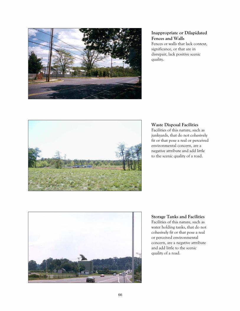
66
Inappropriate or DilapidatedFences and WallsFences or walls that lack context,significance, or that are indisrepair, lack positive scenicquality.
Waste Disposal FacilitiesFacilities of this nature, such asjunkyards, that do not cohesivelyfit or that pose a real or perceivedenvironmental concern, are anegative attribute and add littleto the scenic quality of a road.
Storage Tanks and FacilitiesFacilities of this nature, such aswater holding tanks, that do notcohesively fit or that pose a realor perceived environmentalconcern, are a negative attributeand add little to the scenicquality of a road.

67
Airports, Railyards, RacingFacilities, Shopping MallsFacilities that require enormousopen acreage for parking andusage or that create excessivenoise levels add little to thequality of a road.
Structures Out of ContextThis category is open to allstructures which are not listed asa negative element but thatdetract from the scenic quality ofa road. An example being apoorly sited structure in anotherwise scenic area.
Road Not Conforming toLandscape ContourAny road design which does notconform to the natural flow ofthe terrain. An example being astraight, flat road through rollingterrain where excessive cut andfill has been utilized.
D. Other

68
Structures Intrude on ViewObjects that obstruct or intrudeinto a viewshed contribute littleto the scenic quality of a road. Anexample being atelecommunications towerstanding within a panorama or ascenic hill and valley.
LitterLitter detracts from the scenicquality of a road, especially whenwithin the right-of-way viewshed.
High Traffic VolumesRoads where heavy trafficvolumes are prevalent throughoutthe day should be weighedaccording to their relevance to ascenic view.

69
Excessive Road CutsThe presence of excessive curbcuts along a roadway to homesand businesses are a negativeattribute to the drivingexperience.
GeneralAny other landscape features notspecified above, such as detentionbasins, landscape buffers, andstreet tree plantings that throughdesign, lend a negative attributeto a scenic road or landscape.

70

71
APPENDIX: B
SCENIC ROADWAY INVENTORY AND RATINGSYSTEM
Figure 15. Seasonal effects as viewed from scenic Manassa Road (County Route 21) in the Township ofHowell.

72

73

74

75
APPENDIX C
RESEARCH AND DEVELOPMENT: PREPARATIONOF SCENIC ROADWAY DESIGNATION CRITERIA
Staff of the Monmouth County Planning Board began this plan by compiling and
reviewing information published by federal, state and local agencies and non-profit groups
that have either implemented scenic roadway programs or that have addressed issues
related to the preservation of scenic corridors, byways and roadways. The focus of the
research was on the scenic roadway designation process and the methods of protection
developed in each program. This appendix provides a detailed description of the research
and work that went into the preparation of the Monmouth County Scenic Roadway Study.
A Scenic Roadway: What Is It?
There have been numerous definitions written by various agencies and organizations
describing the various elements that make up a scenic roadway. The defining term itself
has varied from program to program: scenic roadway, byway, corridor, or highway. For
example, the Scenic Byway Task Force in North Carolina developed this definition for a
scenic byway:
…a scenic byway is a rural route providing an altered pace to the faster paced trafficand commercial areas found on major highways and consists of natural, cultural,historical and aesthetic qualities for motorists to view.
In Connecticut, their General Statutes (7-147a) describe a scenic roadway as:
scenic roadway: any state highway or portion thereof that (1) passes throughagricultural land or abuts land on which is located an historic building or structurelisted on the National register of Historic Places or the state register of historicplaces, compiled pursuant to section 10-321 of the general statutes, or (2) affordsvistas of marshes, shoreline, forests with mature trees or notable geologic or othernatural features.

76
Finally, the 1985 Standards for Scenic Corridors in Washoe County, Nevada proposed a two-tier
definition that defined the roadway based on the relative proximity of scenic elements
from the roadway:
The term, “scenic corridor” and “scenic roadway” will be used to refer to twodifferent situations. The term “scenic corridor” refers to a roadway with recognizedhigh quality visual amenities that include background vistas of mountains, opencountry, or city. “Scenic roadways”, on the other hand, have high quality visualresources that are mainly limited to the adjacent property and right-of-way.
As definitions varied, there were four elements that were commonly discussed in each
scenic roadway definition. The four elements were:
1. All scenic roadways are multi-use traveled ways.2. All scenic roadways traverse through an environment composed of multiple
elements (natural, man-made, historical, cultural, recreational, views,topography, etc.).
3. The environment surrounding all scenic roadways is ever-changing due to theterrain, elevation, and the proximity of natural and man-made elements fromthe roadway edge.
4. The environment through which a person traverses affects both their visual andpsychological perceptions and impressions.
When combined together as one definition, these four elements clearly define the
composition of a scenic roadway. As a result, a Scenic Roadway in Monmouth County is
defined as follows:
Scenic Roadway: a public thoroughfare for the passage of vehicles, persons, or animalswhich traverses through an ever-changing, aesthetically pleasing environment that consists ofnatural and man-made elements which stimulate the senses and leave a lasting impression inthe mind.
This definition provided the foundation on which to begin developing the designation
criteria elements to determine which roadways in Monmouth County are scenic.

77
Case Study Review of Criteria Elements
Not surprisingly, the numerous programs reviewed had their own methodology for
designating roadways as scenic. The staff determined that some of the inventory-based
programs were compatible with the goals of Monmouth County’s Scenic Roadway Study.
Elements from some of the programs discussed in this section were helpful in developing
the methodology of Monmouth County’s Scenic Roadway Inventory and Rating System
criteria.
The review of the various programs revealed that designation criteria elements and ranged
from broad classifications to refined inventories of elements found within the
environment. For example, Tinicum Township, Pennsylvania, adopted an ordinance for
scenic roadway designation in 1989. Tinicum Township’s designation criteria establishes a
minimum roadway length and requires that certain natural and man-made features must
be present for the roadway to qualify as scenic. A portion of the ordinance concerning the
designation criteria is listed below:
A. Length. The portion of roadway to be designated scenic shall be at least one-half mile in length, unless the entire roadway is less than one-mile in length, orunless one end of the scenic portion abuts a roadway already designated asscenic. A roadway shall be considered to be the “entire roadway” only if it doesnot directly connect at either end with a continuing roadway of the same name.
B. Other Criteria. At least one of the following features which gives character tothe landscape shall also be met:
1. the roadway is unpaved;2. the roadway is bordered by mature trees forming a canopy over the roadway, or
dry stone walls greater than 100’ in length;3. the roadway parallels or crosses over a river, canal, stream or pond;4. the roadway offers scenic views of natural beauty, or of historical or cultural
significance.
In 1990, the State of Wisconsin produced a document listing a minimum of seven criteria
that a roadway had to possess in order to be considered for scenic, or “rustic”, designation.
The required criteria include the following:

78
1. A rustic roadway has outstanding natural features along its borders such asragged natural terrain, native vegetation, or includes open areas with rustic oragricultural vistas which, singly or in combination, set this roadway apart fromother roadways as being something unique and distinct.
2. A rustic roadway is a low-volume local use public roadway which is usable year-
round.
3. A rustic roadway functions as a local access roadway, i.e., one which serves theadjacent property owners and those wishing to travel by auto, bicycle or hiking,for purposes of enjoying its rustic features. This would generally precludedesignation as a rustic roadway any roadway serving as a collector or arterial asdefined in Ch. HY35, Wis. Adm. Code.
4. A rustic roadway is not one scheduled or anticipated for major improvementwhich would change its rustic characteristics.
5. A rustic roadway preferably has no high density development along it, but thedevelopment as it exists at the time the roadway is designated shall be incompatible with the surroundings and shall not detract from the rustic, natural,unspoiled character and visual impact of the roadway area.
6. A rustic roadway preferably has a minimum length of 2 miles and, wherefeasible provides a completed closure or loop or connects to a major highway atboth ends of the route.
7. The land adjacent to the rustic roadway preferably is zoned compatible with themaintenance or preservation of its rustic character and low densitydevelopment. (Wisconsin Department of Transportation, Chapter Trans-RR1-1,21, 1981)
Wisconsin’s designation criteria focused attention not only on the characteristics
associated with rustic roadways but also on the more finite elements of the environment.
In their document entitled, “Final Case Study for the National Scenic Byways Study: Wisconsin’s
Rustic Roadway Program (FHWA-ED 90-032, 1990), an inventory form was implemented to
classify the elements of the scenic environment into two attribute columns, positive and
negative. The form further identified the active recreational uses, visual features, and most
dominant land uses and rated them accordingly using a rating system.
A similar method of designation criteria was developed and adopted by Vermont in 1977.
The Vermont Scenery Preservation Council published a document entitled Designating
79
Scenic Roadways, A Vermont Field Guide, a comprehensive document describing the process
for delineating the best scenic roadways in Vermont. The designation criteria involved a
two step process. In step one, an inventory would be conducted of the elements contained
within each one-mile segment of the scenic environment. The elements were then rated
for both positive and negative attributes as well as their overall quality on a scale of one to
ten, with ten being of the highest quality. The document also provided a listing of
terminology describing the elements of the environment. The second step involved a
scoring system which accompanied the inventory form, thus guiding the designation
process in the careful selection of the proposed scenic roadways.
An analysis of both the Vermont Field Guide and Wisconsin’s designation criteria found
close similarities in their approach and inventory process. Vermont’s program, however,
introduced a few new innovative methods to the designation process. It provided an
inventory and check-off section on the form to expedite field surveys and included
terminology to describe the natural and man-made elements that existed in the scenic
environment.
A far different approach to the designation process was developed by the State of Nevada.
Nevada utilized the American Society of Landscape Architects’ approach of visual impact
assessment to designate scenic roadways or corridors. According to the document,
Standards For Scenic Corridors In Washoe County, Nevada, prepared in 1985, the document
applied four criteria to all roadways:
1. Vividness. Visual vividness is the power or memorability of landscapecomponents as they combine in striking and distinctive visual patterns. NiagaraFalls and New York City skyline are examples of visual and man-madelandscapes with high vividness.
2. Intactness. Visual intactness refers to the integrity of the landscape, eithernatural or man-made, and the relative degree of encroaching elements. Forexample, an intrusive highway may destroy the intactness of either the countryor the city.

80
3. Unity. Visual unity refers to the coherence and compositional harmony of thelandscape considered as a whole. This criterion can reflect the careful design ofindividual components of a landscape.
4. Community Importance. The importance to the community determines thesignificance of visual quality as defined by the first three criteria. Streets orcorridors that are barely above average in visual quality may have extremeimportance or cultural history.
Each of the criteria were then rated on a simple five-point numeric scale with five being the
highest. A final corridor rating was attained by adding the resultant score for each category
together. The score determined the suitability of a roadway for scenic roadway or corridor
designation. A predetermined score was applied to aid in the determination process.
Nevada’s program, however, did not specify a minimum length or segment requirement for
which this process was to be applied, allowing the score results to vary tremendously.
New Jersey’s Scenic Byways Program was also found to be very innovative. In order to
nominate a roadway as scenic, three inventory and assessment forms are required to be
completed. The first form, a physical survey, consists of an inventory of the attributes of
the environment. Each attribute is then rated for its visual significance on a scale of
positive five to negative five, with positive five being of the highest quality. The results are
then averaged to obtain the final score. The second form utilizes a visual survey similar to
the Washoe County, Nevada survey. The survey evaluates the overall pattern and
characteristics of the environment through which the scenic roadway traverses and rates it
on a scale of one to five, with five being of the highest visual quality and cohesiveness. The
third and final survey involves an institutional survey to evaluate the roadway’s potential
for management and enhancement. New Jersey’s program places limits on the minimum
and maximum survey length which ranges from one-tenth of a mile in urban settings to
one mile in areas where great expanses of open roadway and terrain exist.
The County of Somerset, New Jersey developed a comprehensive scenic roadway study that
(Somerset County Scenic Corridor and Roadway Study, 1989) utilizes numerous elements from
various programs including the same general two-step designation process employed by
81
Vermont and Wisconsin. The first step involves taking an inventory of the natural and
man-made elements of the landscape in one-half mile segments. The elements are then
classified as either positive or negative attributes. The second step in the process utilizes a
numeric rating system that rates the elements on a scale of one to five; with five being of
the highest quality. A predetermined cut-off score serves as a guide in the selection of
scenic roadways. The Somerset County study also includes an expanded terminology
section that describes the elements of the scenic environment in more detail.
The designation criteria methodology described above provided planning board staff with a
basis for the preparation of the scenic roadway designation criteria for Monmouth County.
Development of Inventory and Rating System Criteria
The next phase of the Monmouth County Scenic Roadway Plan involved developing
criteria for an inventory and rating system. Parameters were established by which the
inventory and rating system had to adhere, as described below:
1. The criteria and terminology should be clearly understandable and definable.
2. The criteria should be applicable to all regions of Monmouth County.
3. The designation criteria procedures should be easy to interpret, easy to followand applicable by both professionals and laypersons.
4. The criteria should be readily transferable to any government agency ororganization wishing to utilize this program for their own purposes.
An attribute list comprises the first component of the Monmouth County Scenic Roadway
Inventory and Rating System Survey. The list identifies the major attributes of the
environment and divides them into two categories: positive attributes and negative
attributes. The positive attribute category includes: Vegetation, Landscape
Composition/Effects, Roadway Characteristics, Water Composition/Effects, Structures,
Other Man-made Structures, and Wildlife Features. The negative attribute category
includes: Landscape Scars, Structures, and Other Man-made Structures. Attributes that
82
did not seem to fit into an appropriate attribute category were to be listed in a heading
entitled “Other”. Each major attribute category contains a list of sub-elements relating to
that attribute, thus providing a thorough list of features existing within the environment.
The Monmouth County Scenic Roadway Survey includes a designation check-off column –
as the roadway is being surveyed, a checkmark is placed on the survey form next to the
feature/attribute that is present within that roadway segment. With the decision by staff to
review roadways in one-half mile segments, it was necessary to include two columns; one
for each direction of travel, allowing for a more accurate inventory of the scenic elements.
Finally, a rating system was developed to rate the elements for their overall quality and
cohesiveness to the roadway on a scale of one to five, with five being the highest. For
example, a modern industrial warehouse sited within an old historic residential district would
not rate particularly high since it does not fit within the context of the surrounding
environment. A separate column was added for elements located within the roadway’s
right-of way. The survey form provides a section for the surveyor to write down additional
comments such as overall impression of the roadway or a brief description of the features
present along the roadway. A sample of the Monmouth County Scenic Roadway Inventory
and Rating System Survey is found in Appendix B of this report.
Development of the Scenic Roadway Terminology
To provide a more clear understanding of the various elements found within the
environment, planning board staff developed a comprehensive description of the
terminology utilized in the attributes list of the Monmouth County Scenic Roadway
Inventory and Rating System Survey. To be consistent with the designation criteria
parameters, all the terms were developed to be clearly understandable and easily definable.
A complete description of the Rating Category Terminology has been assembled in a
glossary located in Appendix A of this report.

83
APPENDIX D
MONMOUTH COUNTY PLANNING BOARD SCENICROADWAY RESOLUTION

84
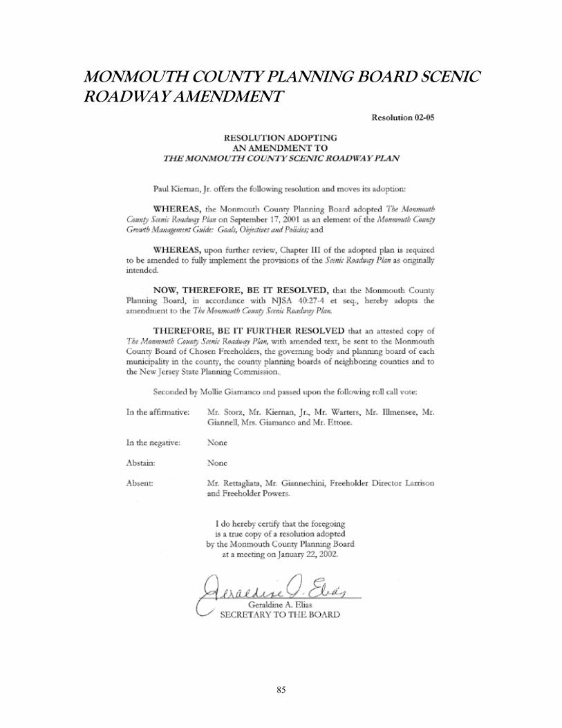
85
MONMOUTH COUNTY PLANNING BOARD SCENICROADWAY AMENDMENT

86

87
BIBLIOGRAPHY
Adler, II, Leopald, J. Myrick Howard, Drew C. Boggs, Reid Williamson, Arthur P. Ziegler,Jr., Susan J. Lutzker and Harriet Plyler. Words From The Wise: Revolving Fund VeteransShare Their Experiences.” The Journal of the National Trust for Historic Preservation:Historic Preservation Forum. Vol. 12, No. 1. 1997.
American Association of State Highway and Transportation Officials. A Policy onGeometric Design of Highways and Streets. Washington, D.C. 1990.
American Association of State Highway and Transportation Officials. Roadside DesignGuide. Washington, D.C. 1988.
American Planning Association. “Rethinking Urban Gateways.” Planning Advisory ServiceMemo. 1992.
American Planning Association. “Preparing A Landscaping Ordinance.” Planning AdvisoryService Report. No. 431. 1990.
American Planning Association. “Designing Urban Corridors.” Planning Advisory ServiceReport. No. 418.
Ansis, Karen. “Our Beloved Borrowers: The Human Side of Lending.” The Journal of theNational Trust for Historic Preservation: Historic Preservation Forum. Vol. 12, No. 1.1997.
Arendt, Randall. “Conservation Design for Subdivisions: A Practical Guide to CreatingOpen Space Networks.” Island Press. 1996.
Arrowhead Regional Development Commission. Scenic Routes of the Arrowhead.Minnesota Department of Transportation. 1995.
Bainbridge, Bob. “Improving Corridors.” The Palmetto Planner. Vol. 18, No. 1. 1996.
Battin, Maryel and Jordan Jelks. “Huguenin Heights: A Community Partners Project.” TheJournal of the National Trust for Historic Preservation: Historic Preservation Forum. Vol.12, No. 1. 1997.
Beaumont, Constance Epton. “Property Rights and Civic Responsibilities.” The Journal ofthe National Trust for Historic Preservation: Historic Preservation Forum. Vol. 7, No. 4.1993.
88
Burlington County Board of Chosen Freeholders. Planning for Transfer of DevelopmentRights: A Handbook for New Jersey Municipalities. Mount Holly, NJ. 1992.
Cape Cod Commission. Old King’s Highway/Route 6A: Corridor Management Plan.Cape Cod, Massachusetts. 1995.
Township of Colts Neck, New Jersey. Chapter 102, Development Regulations. 2000.
Committee on Environmental and Public Works, U.S. Senate. Scenic Byways: States’ Useof Geometric Design Standards. United States General Accounting Office. 1995.
Copps, David and Will Abberger. “Views From the Road.” The Journal of the NationalTrust for Historic Preservation: Historic Preservation Forum. Vol. 8, No. 3. 1994.
Dehart, H. Grant and Jo Ann Frobouck. “Preserving Public Interests and Property Rights.”The Journal of the National Trust for Historic Preservation: Historic Preservation Forum.Vol. 7, No. 4. 1993.
Delaware and Raritan Canal Commission. Draft Principles and Design Specifications forScenic Roads along the D & R Canal Park. Somerville, New Jersey. 1990.
Doheny, David A. “Property Rights and Historic Preservation”. The Journal of theNational Trust for Historic Preservation: Historic Preservation Forum. Vol. 7, No. 4. 1993.
Elkinton, Steven and Donald C Maglienti. “Preserving America’s National Historic Trails.”The Journal of the National Trust for Historic Preservation: Historic Preservation Forum.Vol. 8, No. 4. 1994.
Fedelchak, Marilyn and Byrd Wood. “Protecting America’s Historic Countryside.”National Trust for Historic Preservation. 1988.
City of Gaithersburg, Maryland. Tree Manual. 1999.
Gillette, Vicki. “Expanding The Pie: Capitalizing Revolving Fund Loans for HistoricPreservation Programs.” The Journal of the National Trust for Historic Preservation:Historic Preservation Forum. Vol. 12, No. 1. 1997.
Governor’s Council on New Jersey Outdoors. Final Report – Summary of Findings.Trenton, New Jersey. 1998.
Guilford Preservation Alliance. Master Plan for Preservation and Scenic Conservation.Town of Guilford, Connecticut. 1995.
Township of Holmdel, New Jersey. Chapter 30, Development Regulations. 1998.

89
Howard, J. Myrick. “Revolving One Revolves Many More.” The Journal of the NationalTrust for Historic Preservation: Historic Preservation Forum. Vol. 12, No. 1. 1997.
Humstone, Elizabeth and Julie Campoli. “Access Management: An Overview.” PlanningCommissioners Journal. 1998.
Hunton, Gail and James C. McCabe. “Monmouth County Historic Sites Inventory:Summary Report.” Office of New Jersey Heritage, Monmouth County Park System,Monmouth County Historical Association. Lincroft, New Jersey. 1984.
Institute of Transportation Engineers. “Geometric Design.” Transportation and TrafficEngineering Handbook, Second Edition. Federal Highway Administration. Washington,D.C. 1982.
Lewis, Thomas A. “Property Rights and Human Rights”. The Journal of the National Trustfor Historic Preservation: Historic Preservation Forum. Vol. 7, No. 4. 1993.
Lutzker, Susan J. and Lyn Howell Moriarity. “Eight Tips for A Successful Revolving Fund.”The Journal of the National Trust for Historic Preservation: Historic Preservation Forum.Vol. 12, No. 1. 1997.
Township of Manalapan, New Jersey. Chapter 130, Development Regulations. 1997.
Metro Main Street Technical Advisory Committee. Main Street Handbook: A User’sGuide to Main Streets. Portland, Oregon. 1996
Metro Main Street Technical Advisory Committee. Regional Mainstreets: AnImplementation Strategy to Promote Main Street and Corridor Development. Portland,Oregon. 1995.
Township of Middletown, New Jersey. Chapter 16, Zoning Ordinance. 1994.
Miller, Anita P. eds. “Planning and Zoning Techniques for Scenic and Historic Roads”.Proceedings of the American Institute of Certified Planners: Eleventh Annual ZoningInstitute. Albuquerque, New Mexico. 1991.
Monmouth County Park System. Park, Recreation and Open Space Plan Amendment.Lincroft, New Jersey. 1998.
Monmouth County Park System. Park, Recreation and Open Space Plan. Lincroft, NewJersey. 1991.
Monmouth County Planning Board. Monmouth County Pedestrian Corridors MobilityConcept Study. Freehold, New Jersey. 2000.

90
Monmouth County Planning Board. Straight Line Diagrams. Freehold, New Jersey. 1997.
Monmouth County Planning Board. Monmouth County Road Plan. Freehold, New Jersey.1996.
Monmouth County Planning Board. Growth Management Guide: Goals, Objectives andPolicies. Freehold, New Jersey. 1995.
Monmouth County Planning Board. Signage Made Simple: A Primer Containing SignDesign Guidelines for Inclusion in Municipal Ordinances. Freehold, New Jersey. 1995.
Monmouth County Planning Board. Community Design: A Guide to Future Developmentin Upper Freehold. Freehold, New Jersey. 1993.
Monmouth County Planning Board. Growth Management Techniques: A GrowthManagement Guide White Paper. Freehold, New Jersey. 1987.
Monmouth County Planning Board. Monmouth County Highway Plan. Freehold, NewJersey. 1986.
Monmouth County Planning Board. Monmouth County Subdivision and Site PlanResolution. Freehold, New Jersey. 1984.
Monmouth County Planning Board. Cluster Development: A Growth Management GuideWhite Paper. Freehold, New Jersey. 1983.
Monmouth County Planning Board. General Development Plan, 1969 – 1985. Freehold,New Jersey. 1969.
Montgomery County, Maryland. “Design Standards.” Department of Public Works andTransportation. 1996.
The National Arbor Day Foundation. Building With Trees: A Comprehensive, Full-DayWorkshop on How to Save Trees During Building and Land Development. Lincoln,ebraska. 1998.
New Jersey Department of Community Affairs. Residential Site Improvement Standards.Title 5, Chapter 21. Trenton, New Jersey. 1997.
New Jersey Department of Community Affairs. Model Subdivision and Site PlanOrdinance. Trenton, New Jersey. 1987.
New Jersey Department of Transportation. Bridges and Structures Design Manual.Trenton, New Jersey. 1998.

91
New Jersey Department of Transportation and The RBA Group. Bicycle and PedestrianPlanning and Facilities Design. Trenton, New Jersey. 1996.
New Jersey Department of Transportation. Statewide Bicycle and Pedestrian Master Plan.Trenton, New Jersey. 1995.
New Jersey Department of Transportation. The New Jersey Scenic Byways Program.Trenton, New Jersey. 1995.
New Jersey Department of Transportation. New Jersey State Highway Access ManagementCode. Trenton, New Jersey. 1992. Amended, 1995.
New Jersey Department of Transportation. Managing Transportation In Your Community:A Municipal Handbook. Trenton, New Jersey. 1989.
New Jersey Shade Tree Federation. “Trees for New Jersey Streets.” Fourth Edition. NewBrunswick, New Jersey. 2000.
New Jersey State Planning Commission. The New Jersey State Development andRedevelopment Plan: Communities of Place. Trenton, New Jersey. 1992.
Pioneer Valley Planning Commission. Jacob’s Ladder Trail Scenic Byway Study:Development. Massachusetts. 1995.
Pioneer Valley Planning Commission. Jacob’s Ladder Trail Scenic Byway Study: Land UseStrategies. Massachusetts. 1994.
Purinton, Bradley and Lester A Hoel. “Planning and Design Issues for Scenic Byways.”Transportation Quarterly. Vol. 45, No. 1. 1991.
Rahenkamp, John E. and William C. Hengst. “Road Corridor Overlay Zoning forRoadside Enhancement.” Urban Land Institute. Vol. 47, No. 5. 1988.
Reed, Charles. “Getting The Most From Powerful Zoning Tools – How To Write EffectiveOverlay Zones.” The Zoning Report. Vol. 14, No. 3. 1996.
Reed, Charles. “Types of Subdivision Option Agreements for Performance Bonds (PartOne).” The Zoning Report. Vol. 14, No. 11. 1996.Reed, Charles. “Types of Subdivision Option Agreements for Performance Bonds (PartTwo).” The Zoning Report. Vol. 14, No. 12. 1996.
Reed, Charles. “How To Provide Comprehensive Landscape Regulations and LandscapingSite Standards in Zoning Codes (Part One).” The Zoning Report. Vol. 9, No. 7. 1991.

92
Reed, Charles. “How To Provide Comprehensive Landscape Regulations and LandscapingSite Standards in Zoning Codes (Part Two).” The Zoning Report. Vol. 9, No. 8. 1991.
Regional Plan Association. Tools and Strategies: Protecting the Landscape and ShapingGrowth. New York. 1990.
Regional Transportation Commission. Standards for Scenic Corridors in Washoe County,Nevada. DeLeuw, Cather & Company. Washoe County, Nevada. 1985.
State of Rhode Island. Rules of Procedure: Organization and Operation of the State ofRhode Island Scenic Highways Board. Rhode Island. Undated Draft.
Robinette, Gary O. “Local Landscape Ordinances.” Community Landscape DevelopmentSeries. Agora Communications. 1992.
Roddewig, Richard J. “Historic Preservation and the Constitution.” The Journal of theNational Trust for Historic Preservation: Historic Preservation Forum. Vol. 7, No. 4. 1993.
Borough of Rumson, New Jersey. Chapter 22, Development Regulations. 1990.
Rypkema, Donovan D. “Property Rights/Property Values.” The Journal of the NationalTrust for Historic Preservation: Historic Preservation Forum. Vol. 7, No. 4. 1993.
Scenic America. Corridor Management Plans for Scenic Byways. Washington, D.C. 1995.
Scenic America. Designation of State Scenic Byways. Washington, D.C. 1995.
Scenic America. The Use and Mis-Use of AASHTO Design Standards. Washington, D.C.1995.
Scenic America. The Value of Nature and Scenery. Vol. 1, No. 3. Washington, D.C. 1992.
Scenic America. Economic and Community Benefits of Scenic Byways. Vol. 2, No. 1.Washington, D.C. 1995.
Scenic America. Evaluating Scenic Resources. Vol. 3, No. 1. Washington, D.C. 1996.
Scenic America. Design Standards on the National Highway System. Washington, D.C.1995.
Scenic America. Preserving a Part of America’s Heritage. Washington, D.C. 1995.
93
Schoettle, Clark. “Partnerships In Providence Help Revitalize Historic Neighborhoods.”The Journal of the National Trust for Historic Preservation: Historic Preservation Forum.Vol. 12, No. 1. 1997.
Borough of Shrewsbury, New Jersey. Chapter 94, Zoning and Land Development. 1994.
Smith, Bob L. and William L. Smith. Scenic Byways: Their Selection and Designation.Transportation Research Record No. 1363. Undated.
Smith, Stanley A. “ Making A Revolving Fund Work.” The Journal of the National Trustfor Historic Preservation: Historic Preservation Forum. Vol. 12, No. 1. 1997.
Somerset County Planning Board. Somerset County Scenic Corridor and Roadway Study.Somerville, New Jersey. 1990.
Township of Tinicum, Pennsylvania. Scenic Roads Ordinance # 69. Tinicum,Pennsylvania. 1989.
Transportation Research Board. “Effective Utilization of Street Width on UrbanArterials.” National Cooperative Highway Research Program Report 330. 1990.
United States Department of Transportation, Federal Highway Administration. RoadwayAesthetic Treatments: Photo Album Workbook. Washington, D.C.: Government PrintingOffice. 2001.
Township of Upper Freehold, New Jersey. Chapter 81, Land Use Regulations Ordinance.1997.
Vermont Scenery Preservation Council and Vermont Transportation Board. DesignatingScenic Roads: A Vermont Fieldguide. Vermont. 1979.

94


MONMOUTH COUNTY BOARD OF CHOSEN FREEHOLDERS
Harry Larrison, Jr., DirectorThomas J. Powers, Deputy Director
Theodore J. NarozanickAmy H. Handlin
Edward J. Stominski
MONMOUTH COUNTY PLANNING BOARD
Members
Joseph Rettagliata, ChairpersonFrederick Storz, Vice Chairperson
Paul Kiernan, Jr.William D. WartersGeorge IllmenseeJames Giannell
Harry Larrison, Jr., Freeholder DirectorThomas J. Powers, Freeholder
Theodore A. Giannechini, P.E., P.P.
Alternate Members
Mollie GiamancoSam P. Alfano
Amy H. Handlin, FreeholderJoseph Ettore, P.E., P.P., County Engineer
Executive Staff
Robert W. Clark, P.P., Director of PlanningBonnie Goldschlag, A.I.C.P., P.P., Assistant Director of Planning
Geri Elias, Secretary to the BoardJohn Schuster III, Esq., Counsel to the Board
CONTRIBUTING STAFF
Author Jeffrey Valiante, Senior Planner
Cover, Photos and Graphics Jeffrey Valiante, Senior PlannerAaron Townsend, Graphics
Editors Robert W. Clark, P.P.Bonnie Goldschlag, A.I.C.P., P.P.Edward Sampson, P.P.

www.monmouthplanning.com