scenario planning workshops summary - ccass
TRANSCRIPT

Colorado River Conversations ProjectScenario Planning Workshops Summary
University of Arizona
This document summarizes the Final Report from three Scenario Planning workshops that were hosted by the University of Arizona between June of 2019 and April of 2020, within the Colorado River Conversations Project (CRC). This overview introduces scenario planning, including its use in the Colorado River Basin and the process used by CRC to develop a unique six-step scenario planning process. Each of the six steps used in the scenario planning process are briefly described, including examples and results from the workshops. For complete descriptions of the project and associated reports, please visit https://ccass.arizona.edu/colo-rado-river-conversations-project.
Introduction
Background: The Colorado River Conversations Project Scenario Planning Workshops
The Colorado River, often called the lifeblood of the Southwestern United States, provides water supplies to nearly 40 million people in seven U.S. Basin States, two Mexican states, and twenty-nine Tribal Nations. It is a highly managed system that has been shaped through extensive supply, delivery, and storage infrastructure projects over the past 100 years, and, more recently, by climate change. Its two largest reservoirs, Lakes Mead and Powell, are approaching levels that could trigger shortages in the Lower Basin, threating the sustainability of hydrological, ecological, economic and environmental resources.
In the context of increasing pressure on the Colorado River, the CRC Project was designed to help build broad, interdisciplinary support and a scientific foundation for management efforts in the basin. The Scenario Planning component of the CRC was focused on helping to identify, consider the implications of, and find common solutions for, extreme events that affect the balance of supplies and demands in the Basin. The project was led by University of Arizona’s Center for Climate Adaptation Science and Solutions (CCASS) in collaboration with Martin & McCoy LLC. It was funded by the Walton Family Foundation.
As part of this initiative, the CRC team supported an innovative three-phased scenario planning process involving 30 people with diverse interests across the seven Basin States, Tribal Nations, and Mexico (Table 1). The overarching goal of the scenario development process and associated discussions was to create a space for the collective exploration of uncertainty related to more extreme events than are considered in most planning discussions. Participants co-produced a broad set of scientifically supported “what if” storylines that explored the implications of low probability/high consequence climate events in conjunction with a range of other drivers that influence risk.
Phase 1
Phase 2
Phase 3
Date Location Objectives
June 2019 Boulder, Colorado Set the contextIdentify and rank “nightmare” driversSelect plausible low probability/high probability consequence scenarios
October 2019 Tucson, Arizona Present detailed scenariosDiscuss impacts across the Basin
April 2020 Virtual* Identify common solutions that address multiple scenariosDescribe useful dieas and research paths forward
* Due to the COVID-19 Pandemic, the April 2020 workshop was held virtually on Zoom, featuring breakout groups and methods of online polling.
Table 1. CRC Scenario Planning Workshops
1

What is Scenario Planning?
Scenario planning is a decision-making tool that allows managers to consider alternative futures and plan under conditions of deep uncertainty. Scenario planning is not a means of predicting the future, rather a systematic way of bracketing uncertainty (Moore et al. 2013). The involvement and contributions of diverse participants is key to building a shared understanding of risks, trade-offs, and possible management actions. In developing scenarios around climate change and other stressors, the process can articulate the potential consequences of uncertainty while empowering decision makers to prepare and respond.
Scenarios are “plausible and often simplified description[s] of how the future may develop, based on assumptions about driving forces and key relationships.” (IPCC 2008). These “plausible futures” can be near‐term and simple, or they may be long‐term and complex, addressing highly uncertain interactions (Moore et al. 2013). They can integrate a range of conditions, including historically average projections, extremes, and low probability but highly disruptive events. Scenarios can use qualitative data, including popular opinions about climate change, as well as quantitative data, such as climate models.
Although scenario planning has been used previously in the Colorado River Basin, earlier versions did not explicitly focus on the potential for a combination of extreme climate, socioeconomic, and policy conditions as the CRC effort did. The most prominent previous Scenario Planning effort at the basin-scale was the US Bureau of Reclamation’s (Reclamation) 2012 Colorado River Basin Water Supply and Demand Study (Basin Study). It examined several possible futures at the intersection of four water supply and six water demand scenarios. Reclamation modeled the effects of increasing demand and sought public input on solutions to address the deficit. Follow-up efforts included the Moving Forward process and the 2018 Colorado River Basin Ten Tribes Partnership Tribal Water Study, which examined future tribal water demand in the basin and included a scenario planning process. The Ten Tribes Study included four storylines of future tribal water development. Effects were quantified through modeling simulations, and challenges and opportunities were identified. Information on the 2012 Water Supply and Demand Study, the Moving Forward process, and the Ten Tribes Partnership Tribal Water Study can be found at https://www.usbr.gov/lc/region/programs/crbstudy.html.
CRC Approach to Scenario Planning
The CRC’s approach to Scenario Planning drew from the expertise of various Scenario Planning experts and review of prior studies. The CRC team worked with Ralph Marra, of Southwest Water Resources Consulting and reviewed previous Scenario Planning efforts related to Climate Adaptation (Garfin et al. 2015; Star et al. 2016; Scenario Planning Workshop Report 2015). The four primary sources of information used to craft the methodology for this three-part workshop are included in the References. The team consulted on a regular basis with an Advisory Committee comprised of experts across the Basin. The Advisory Committee’s guidance was essential in tailoring the design and evolution of the project, including helping to select workshop participants who represented various interests (e.g. water utilities, agriculture, academia, environmental NGOs, etc.) across the seven U.S. basin states, Tribal Nations, and Mexico. The following section describes the six-step scenario planning process, which evolved in real-time from its initial design based on participant input over the 10-month process (Figure 1).
Step 1: Set the Context
Step 3:
Choose Scenarios
Step 5: Explore Impacts of Scenarios
Step 2:
Identify Drivers
Step 4: Research and
Write Scenarios
Step 6: Identify Common
Solutions
Figure 1. Colorado River Conversations ProjectScenario Planning Approach
2

Step 1: Set the Context
The CRC scenario planning process began by explaining the purpose of this scenario planning effort and setting the context for participants. This process was unique because it sought to explore the areas of uncertainty outside the parameters of most planning discussions. It focused on low probability, yet plausible “black swan events” that could occur within the context of extreme climate conditions (Figure 2). Project goals were agreed on by participants to develop a series of scenarios at the basin scale that could also be useful for states, utilities, NGOs or organizations to consider within their own processes. The geographic scope was defined: the entire Colorado River basin within the U.S., Mexico, and Tribal Nations. Finally, the planning horizon was selected: the present to 2050, to incorporate the near-term policy efforts, as well as longer-term management conditions under new guidelines.
ExtremeDrought
ExtremeFlooding
Most Severe Flood within Period
of Record
Most Severe Drought within Period
of Record
Range of Traditional Planning E�orts
Figure 2. Scope of CRC Scenario Planning Workshops
Step 2: Identify Drivers
In step two, participants developed a broad list of possible drivers of change and identified the trends, possible impacts, and/or disruptors for each. The drivers were deliberately selected to create a broad array of possible disruptions which could lead to extreme outcomes. In many cases, it was important to note the initial conditions for these drivers (e.g., precipitation shifting from snow melt to rainfall). Given the objective of the CRC project, climate extremes were set as the “master drivers,” (meaning that there was at least one climate driver in each scenario) but participants also focused on identifying non-climatic drivers related to: governance, ecological, economic, social, legal/political, and physical factors (Figure 3).
3
GovernanceErosion of trust
Less collaboration
Leadership decline
Collapse of the law of the river
No “unbiased” convener
ClimaticWet to dry swings and short-duration intense shocks
Long-duration dry/wet events
No monsoons
Snowmelt to rainfall dominated
Legal/PoliticalLoss of expertise
Lack of credibility
Political agendas overtake the collaboration
US-Mexico conflict
PhysicalMajor infrastructure failure
Water quality decline
Increased reliance on the Colorado (CA system collapse)
Groundwater and aquifers crashEconomic
Changing energy needs
Economic recession
Growing urban/rural divide
Demographic shifts
Tribes lose full value of water
SocialExclusion and zero-sum mentality
Changing social values
Depopulation of rural America
Increased wealth inequity
EcologicalKeystone species extinction
Landscape scale wildfire
Loss of ecosystem values
Figure 3. Key Drivers Identified in June 2019 Workshop

In step three, participants broke out into small groups to develop scenarios by choosing three of the identified important drivers and mapping them using three axes (X, Y, and Z) as shown in Figure 4, below. Eight possible futures emerged from the intersection of the high and low (+, -) presentations of these three drivers. Participants named and described the eight scenarios. Finally, each small group prioritized the scenario(s) that should be developed into more detailed storylines. This process encouraged the development of scenarios that are plausible to participants, distinct from one another, and included long-term trends or threshold-type drivers of change.
Extreme SwingWet to Dry
Extreme SwingDry to Wet
Infrastructure Failure
Robust Infrastructure
Weak Institutions
Strong Institutions
Caught o� Guard
X +X -
Y +
Y -
Z- Z +
4
Figure 5. Colorado River Conversations ScenariosFour storylines developed through the CRC workshops are presented below, each with its three drivers. To see a detailed description of each scenario, including the fact-based evidence, trend information, and references, please visit the CRC webpage.
Caught O� Guard Dig It Deeper
Disaster Strikes Social Shi�s
!
Wet to Dry Swing
InfrastructureFailure
GovernanceFailure
No Monsoon
Aquifer Crash
Increased TribalEngagement in
Lower Basin
Less Snow
Collapse ofCalifornia
Water Systems
BadEconomy
Long DurationDry
IncreasedWealth
Gap
Increased TribalEngagement in
Upper Basin
In step four, a small set of scenarios were chosen for further development based on those prioritized by participants in step three. Figure 5 summarizes the four final storylines that were developed by the CRC team based on the matrices developed by the participants. Each selected three-dimensional scenario was developed into a titled storyline to narrate an accessible and theoretically plausible picture of future conditions. Each storyline was developed using background evidence and/or trend information, including a range of recent climate studies, as well as a list of references for each of the three drivers.
Step 4: Research and Write Scenarios
Step 3: Choose Scenarios
Figure 4. Three-dimensional Matrix Example from Workshop. This matrix is an example constructed by workshop participants. Each group developed three di�erent matrices. Each matrix included three organizing drivers, arranged on a spec-trum. In this example, the drivers are climate “swings” (unexpected changes in climate), infrastructure failures, and governance failure. The scenario, “Caught O� Guard” was created from this matrix and is used as an example in this summary.

Step 6: Identify Common Solutions
Step 6 identifies common solutions across the four final storylines. Participants broke into groups and discussed low-regrets solutions that could mitigate the impacts of each storyline, as well as trade-offs around the benefits and/or challenges of each solution. Then, participants considered which solutions were common across storylines. Finally, participants returned to a plenary discussion of cross-cutting solutions and ultimately developed a set of low-regrets solutions that could apply to many if not all of the storylines (Figure 7).
5
Figure 7. Summary of Low-regrets Solutions
Governance
Social
Economic
Science
Solutions with co-benefits across regions and sectors
Greater flexibility for water transfers
Redundant water supplies and
strategic water reserves
Water conservation and demand management Expanding and
building water leadership across the
basin
Collaboration and alliance-building
across sectors
Diversifying options for communicating
hydrologic risk
Develop contingency plans and continuity
of operations planning across multiple scales
Connecting benefits of water manage-
ment, environmental systems, and public
health
Investments in Tribal infrastructure,
capacity, and water supplies
Developing creative financing for
implementation of solutions Access to best
available science for decision-making
Research into multiple water
supply benefits of watershed manage-
ment
Best practices for implementing
technology solutions (e.g. green
infrastructure)
In step five, organizers facilitated a discussion of impacts across the basin for each of the storylines. Participants were asked to consider six categories of impacts. • Legal/Political • Governance • Ecological • Physical • Social • Economic By design, the storylines were diverse. For example, the Caught Off Guard storyline, which described climate swings from wet to dry, infrastructure failure, and governance failure, could result in the impacts outlined in Figure 6.
Step 5: Explore Impacts of Scenarios
Figure 6. Impacts of the Caught O� Guard Storyline
Economic
Inability to solve future problems – litigation dominates
Inability to enforce existing laws
Less growth
Refugee crisis
Local market collapse
Augmentation options -regional and dependent on funding
More dependence on desalination in Southern California
Funding becomes a source of conflict and uncertainty
Initial releases inundate rivers, but natural flow regime breaks down
In Lower Basin, almost all streams are dry or convert-ed to canals
Higher fire risk
Erosion of environ-mental protection
Communities try to maximize alloca-tions
Upper basin cannot meet lower basin needs
Day Zero (a term borrowed from the Cape Town, South Africa drought to refer to a day when a region could run out of supplies):US: Tucson, Salt Lake City, Northern front range
Mexico: Tijuana, Tecate, and Ensenada
Physical
Ecological
Dam Failure
Loss/damaged spillways and emergency spillways
Flood control limitations
No supply resilience
Flooding damages other aspect of delivery infrastructure
Governance
Social

6
For additional information, please visit the Colorado River Conversations page of the CCASS website (https://ccass.arizona.edu/colorado-river-conversations-project). A full report of the three scenario planning workshops is available, as well as complete descriptions of the four storylines (also presented in Appendix A). Background on Colorado River Conversations and resources of the Colorado River are also provided.
Additional Resources
Garfin, G.M., Black, M., & Rowland, E. 2015. “Advancing scenario planning for climate decision making.” EOS: Transactions of the American Geophysical Union, 96.
IPCC – Intergovernmental Panel on Climate Change – Fourth Assessment Report. 2008. Glossary. “Climate Change 2007: Synthe-sis Report.” IPCC Press. Accessed November 19, 2012 http://www.ipcc.ch/publications_and_data/ar4/syr/en/annexes.html.
Moore, S.S., N.E. Seavy, and M. Gerhart. 2013. “Scenario planning for climate change adaptation: A guidance for resource managers. Point Blue Conservation Science and California Coastal Conservancy.” http://pointblue.org/wp-content/up-loads/2018/06/CCScenarioPlanning_12263_Moore2013.pdf
Scenario Planning Workshop Report. 2015. “Scenario Planning for Climate Change Adaptation Decision Making: The State of the Art.
Southwest Water Resources Consulting (https://swrcscenarios.com/) and conversations with principle, Ralph Marra (April-May 2019). https://ccass.arizona.edu/sites/default/files/Scenario%20Planning%20Workshop%20Report.pdf
Star, J., E.L. Rowland, M.E. Black, C.A.F. Enquist, G. Garfin, C. Hawkins Hoffmann, H. Hartmann, K.L. Jacobs, R.H. Moss, and A.M. Waple. 2016. ”Supporting adaptation decisions through scenario planning: enabling the effective use of multiple methods. “ Climate Risk Management, 13 (2016): 88-94.
References
We would like to thank the Walton Family Foundation for their generous support and grant that made this effort possible. We are grateful to the Advisory Committee for contributing their time and efforts to guiding and participating in this process – their suggestions and insights improved every step. We also appreciate the time and energy of the Scenario Planning participants, who infused each workshop with creativity and possibility.
Acknowledgements
This scenario planning process highlighted the importance of providing safe and creative spaces to engage in difficult discussions about unsettling but plausible futures. Throughout the workshop series, participants acknowledged the range and level of risk to Colorado River water supplies and were able to identify preliminary steps to reduce risk. Individually and collectively, participants engaged in creative conversations about uncertainty and potential strategies to increase preparedness to unexpected future events. In addition, the group acknowledged that a diversity of perspectives, needs, and values is essential to create a well-rounded understanding of the realities and implications of water management in the basin.
The incredible complexity and uncertainties of the Colorado River makes planning difficult. Scenario planning as a framework can create opportunities for a diverse set of stakeholders to participate in thoughtful conversations, deepen understanding of the system and the people within it, and support solutions to respond to emerging challenges.
The enthusiasm expressed by participants about this process confirmed that academics can help to create a space for important conversations about topics that are difficult to discuss in other arenas. In sum, the workshop series underscored the importance of expanding the knowledge network within Colorado River management discussions.
Insights Gained
7
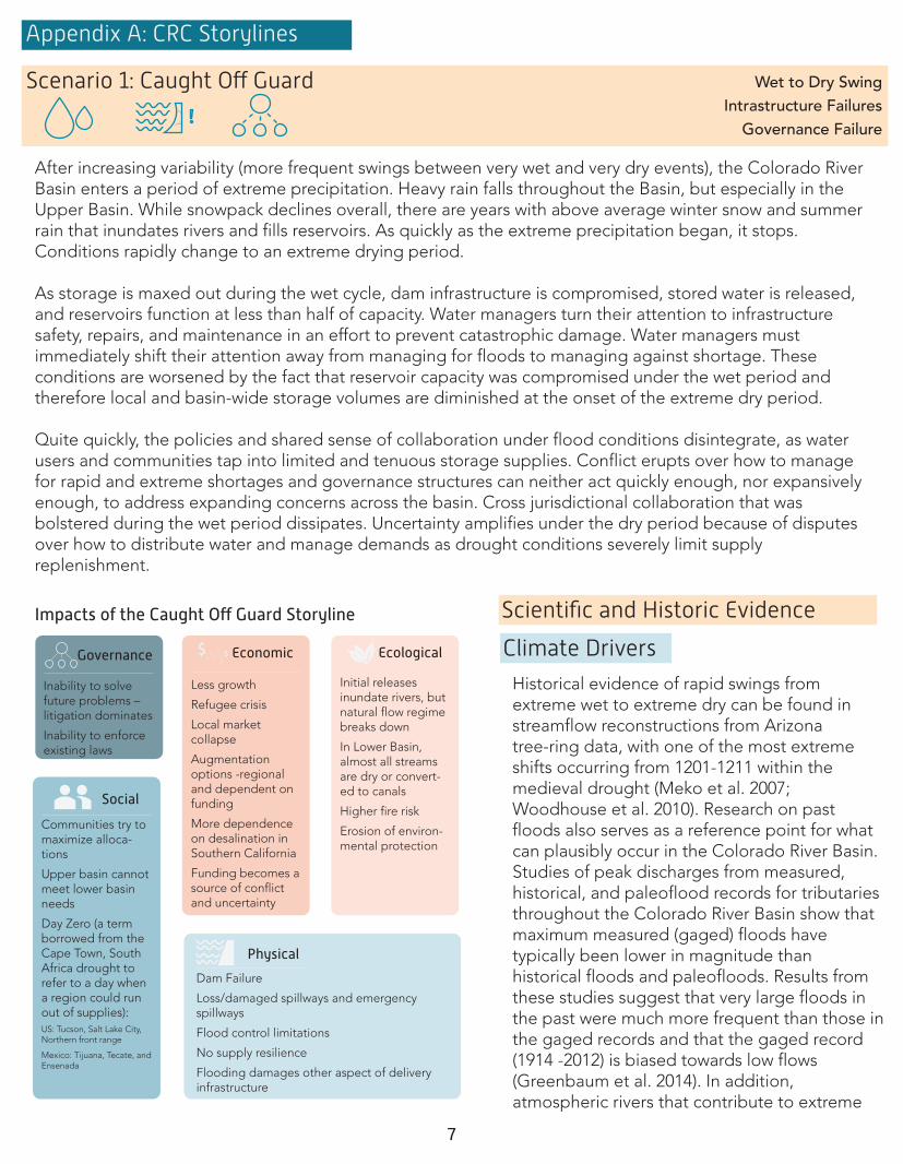
Appendix A: CRC Storylines
After increasing variability (more frequent swings between very wet and very dry events), the Colorado River Basin enters a period of extreme precipitation. Heavy rain falls throughout the Basin, but especially in the Upper Basin. While snowpack declines overall, there are years with above average winter snow and summer rain that inundates rivers and fills reservoirs. As quickly as the extreme precipitation began, it stops. Conditions rapidly change to an extreme drying period.
As storage is maxed out during the wet cycle, dam infrastructure is compromised, stored water is released, and reservoirs function at less than half of capacity. Water managers turn their attention to infrastructure safety, repairs, and maintenance in an effort to prevent catastrophic damage. Water managers must immediately shift their attention away from managing for floods to managing against shortage. These conditions are worsened by the fact that reservoir capacity was compromised under the wet period and therefore local and basin-wide storage volumes are diminished at the onset of the extreme dry period.
Quite quickly, the policies and shared sense of collaboration under flood conditions disintegrate, as water users and communities tap into limited and tenuous storage supplies. Conflict erupts over how to manage for rapid and extreme shortages and governance structures can neither act quickly enough, nor expansively enough, to address expanding concerns across the basin. Cross jurisdictional collaboration that was bolstered during the wet period dissipates. Uncertainty amplifies under the dry period because of disputes over how to distribute water and manage demands as drought conditions severely limit supply replenishment.
Scientific and Historic Evidence
Climate Drivers
Scenario 1: Caught O� Guard
!
Wet to Dry Swing Intrastructure Failures
Governance Failure
Historical evidence of rapid swings from extreme wet to extreme dry can be found in streamflow reconstructions from Arizona tree-ring data, with one of the most extreme shifts occurring from 1201-1211 within the medieval drought (Meko et al. 2007; Woodhouse et al. 2010). Research on past floods also serves as a reference point for what can plausibly occur in the Colorado River Basin. Studies of peak discharges from measured, historical, and paleoflood records for tributaries throughout the Colorado River Basin show that maximum measured (gaged) floods have typically been lower in magnitude than historical floods and paleofloods. Results from these studies suggest that very large floods in the past were much more frequent than those in the gaged records and that the gaged record (1914 -2012) is biased towards low flows (Greenbaum et al. 2014). In addition, atmospheric rivers that contribute to extreme
Shifting monsoon patterns have a significant impact on water supply, including surface water andgroundwater resources. From 1985-2010, roughly 40% of water withdrawals in the Lower Basin werederived from groundwater (Maupin et al. 2018). Variability in precipitation will influence the amount of wateravailable for recharge and replenishment (Green et al. 2011, Niraula et al. 2017). Studies using variousmethodologies suggest that overall recharge rates will decrease in the western United States by up to 20%
and in the southwest U.S. regions by roughly 10-20% (Meixner et al. 2016, Niraula et al. 2017). Paired withdecreasing streamflow and widespread acknowledgement that reservoir storage alone is inadequate tomeet allocations, groundwater resources will be tapped more intensely and will decline more rapidly underthis scenario, threatening water security locally and basin-wide (Castle et al. 2014).
weather and precipitation events are expected to decrease in frequency, but increase in duration and intensity in the western United States (Espinoza et al. 2018).
Impacts of the Caught O� Guard Storyline
Economic
Inability to solve future problems – litigation dominates
Inability to enforce existing laws
Less growth
Refugee crisis
Local market collapse
Augmentation options -regional and dependent on funding
More dependence on desalination in Southern California
Funding becomes a source of conflict and uncertainty
Initial releases inundate rivers, but natural flow regime breaks down
In Lower Basin, almost all streams are dry or convert-ed to canals
Higher fire risk
Erosion of environ-mental protection
Communities try to maximize alloca-tions
Upper basin cannot meet lower basin needs
Day Zero (a term borrowed from the Cape Town, South Africa drought to refer to a day when a region could run out of supplies):US: Tucson, Salt Lake City, Northern front range
Mexico: Tijuana, Tecate, and Ensenada
Physical
Ecological
Dam Failure
Loss/damaged spillways and emergency spillways
Flood control limitations
No supply resilience
Flooding damages other aspect of delivery infrastructure
Governance
Social

8
Infrastructure
A failure of a dam, particularly Hoover or Glen Canyon Dams, would have an immediate and significant impact on the Colorado River Basin and beyond. In 1983, three years after Lake Powell filled, a distinctly long winter was fueled by the 1982-2983 El Niño, dropping exceptional snowpack throughout the basin. Dam managers had projected a normal winter, but spring ended with a sudden influx of warm weather, snow melt and then rain. Upper Basin reservoirs were overwhelmed and water rushed into Lake Powell, placing stress on the structural components of Glen Canyon Dam (Bureau of Reclamation 1984). Disaster was averted; however, following this peak elevation, levels in Lake Powell dropped precipitously, at a speed that could not be accommodated today without substantial economic and environmental impacts. Among the many takeaways for the future, the 1983 flood and following years demonstrate a) how quickly conditions can change and b) how connected storage systems are along the entire river. In addition, dam and infrastructure failure or lowering reservoir elevations to prevent failure can limit storage capacity, further constraining available supplies as conditions shift from wet to dry.
While the Colorado River Basin has a recent history of collaborative actions to manage against shortage conditions (Bureau of Reclamation 2007; IBWC 2012, 2017; 116th Congress 2019), drought conditions can challenge the ability for states, tribes, and other jurisdictions to reach management solutions outside of litigation. Recent successes in Colorado River management have been strongly supported by the Secretary of the Interior and a highly professional team at the U.S. Bureau of Reclamation. If these agencies no longer played a trusted leadership role in the Basin, access to credible data and leadership of multi-jurisdictional planning processes could be compromised. Without such leadership, it would be difficult to navigate climate-related stress and the Colorado River Basin could follow the path of the Rio Grande Basin where disputes about allocations and priority rights are resolved through litigation.
116th Congress. 2019. “Colorado River Basin Drought Contingency Plans.” Vol. 133 Stat 850. https://www.congress.gov/116/plaws/-publ14/PLAW-116publ14.htm
Bureau of Reclamation. 1984. “13th Annual Report: Operation of the Colorado River Basin 1983, Projected Operations 1984.” https://www.usbr.gov/lc/region/g4000/aop/AOP83.pdf
———. 2007. “Record of Decision: Colorado River Interim Guidelines for Lower Basin Shortages and the Coordinated Operations for Lake Powell and Lake Mead.” US Department of the Interior. https://www.usbr.gov/lc/region/programs/strategies/Re-cordofDecision.pdf
Espinoza, V., Waliser, D.E., Guan, B., Lavers, D.A., and F.M. Ralph. 2018. “Global Analysis of Climate Change Projection Effects on Atmospheric Rivers.” Geophysical Research Letters 45 (9): 4299–4308. https://doi.org/10.1029/2017GL076968.
Greenbaum, N., Harden, T.M., Baker, V.R., Weisheit, J., Cline, M.L., Porat, N., Halevi, R. and J. Dohrenwend. 2014. “A 2000 Year Natural Record of Magnitudes and Frequencies for the Largest Upper Colorado River Floods near Moab, Utah.” Water Resources Research 50 (6): 5249–69. https://doi.org/10.1002/2013WR014835.
IBWC. 2012. Minute No. 319: “Interim International Cooperative Measures in the Colorado River Basin Through 2017 and Extension of Minute 318 Cooperative Measures to Address the Continued Effects of the April 2010 Earthquake in the Mexicali Cally, Baja California.” https://www.ibwc.gov/Files/Minutes/Minute_319.pdf
———. 2017. Minute No. 323: “Extension of Cooperative Measures and Adoption of a Binational Water Scarciy Contingency Plan in the Colorado River Basin.” https://www.ibwc.gov/EMD/Minute323.html
Meko, D.M., Woodhouse, C.A., Baisan, C.A., Knight, T., Lukas, J.J., Hughes, M.K. and M.W. Salzer. 2007. “Medieval Drought in the Upper Colorado River Basin.” Geophysical Research Letters 34 (10): L10705. https://doi.org/10.1029/2007GL029988.
Woodhouse, C. A., D. M. Meko, G. M. MacDonald, D. W. Stahle, and E. R. Cook. 2010. “A 1,200-Year Perspective of 21st Century Drought in Southwestern North America.” Proceedings of the National Academy of Sciences 107 (50): 21283–88. https://-doi.org/10.1073/pnas.0911197107.
Historical evidence of rapid swings from extreme wet to extreme dry can be found in streamflow reconstructions from Arizona tree-ring data, with one of the most extreme shifts occurring from 1201-1211 within the medieval drought (Meko et al. 2007; Woodhouse et al. 2010). Research on past floods also serves as a reference point for what can plausibly occur in the Colorado River Basin. Studies of peak discharges from measured, historical, and paleoflood records for tributaries throughout the Colorado River Basin show that maximum measured (gaged) floods have typically been lower in magnitude than historical floods and paleofloods. Results from these studies suggest that very large floods in the past were much more frequent than those in the gaged records and that the gaged record (1914 -2012) is biased towards low flows (Greenbaum et al. 2014). In addition, atmospheric rivers that contribute to extreme
Governance
Citations
Shifting monsoon patterns have a significant impact on water supply, including surface water andgroundwater resources. From 1985-2010, roughly 40% of water withdrawals in the Lower Basin werederived from groundwater (Maupin et al. 2018). Variability in precipitation will influence the amount of wateravailable for recharge and replenishment (Green et al. 2011, Niraula et al. 2017). Studies using variousmethodologies suggest that overall recharge rates will decrease in the western United States by up to 20%
and in the southwest U.S. regions by roughly 10-20% (Meixner et al. 2016, Niraula et al. 2017). Paired withdecreasing streamflow and widespread acknowledgement that reservoir storage alone is inadequate tomeet allocations, groundwater resources will be tapped more intensely and will decline more rapidly underthis scenario, threatening water security locally and basin-wide (Castle et al. 2014).
weather and precipitation events are expected to decrease in frequency, but increase in duration and intensity in the western United States (Espinoza et al. 2018).

9
The North American Monsoon shifts significantly to a new pattern of fewer, but more intense, storms thatcause localized flooding and alter the timing and location of groundwater recharge. Historically, themonsoons have provided over half of annual precipitation to Arizona, New Mexico, and portions of southern Colorado. Under the new pattern, the monsoon season starts later and ends earlier, at times delivering little to no rain in June, July, and August, which were historically the height of the monsoon season.
As the monsoon weakens, tributary and local streams are de-watered for longer periods of time. Localizedflooding from dispersed high intensity storms affects the rate, timing, and distribution of streambedrecharge and contributes to over-taxed and declining aquifers. Aquifers in the Lower Colorado River Basin,and in Arizona specifically, begin to crash. With climate-induced aquifer drawdown, water users look toother sources of water to shore up their supplies.
Tribes are fully engaged in water management decision-making in the Lower Basin and are essentialplayers in both state water management processes and basin-wide conversations. Tribes have developed adiverse array of water management tools, including water banking and aquifer recharge projects, principallyin Arizona.
Scenario 2: Dig It Deeper No Mosoon Aquifer Crash
Increased Tribal Engagement in Lower Basin
Scientific and Historic Evidence
Climate Drivers
The North American Monsoon (NAM) provides approximately 70% of the total annual rainfall for the southwestern U.S. and northern Mexico states (Sheppard et al. 2002). NAM is critical for soil moisture, groundwater recharge, ecosystem functions, rangeland grazing, and agriculture in Arizona and New Mexico in particular. Studies indicate that NAM may experience significant declines in early season precipitation (June-July) and increased precipitation later in the monsoon season (September-October) (Truettner et al. 2019; Cook and Seager 2013). In some years, these shifts may result in an overall reduction in precipitation in the Lower Basin (Pascale et al. 2017), though as the global climate warms, models suggest that there will be more extreme precipitation events that could also deliver average to above average precipitation, albeit in fewer storms that occur later in the season (Pascale et al. 2018; 2019).
Aquifer Crash
Shifting monsoon patterns have a significant impact on water supply, including surface water andgroundwater resources. From 1985-2010, roughly 40% of water withdrawals in the Lower Basin werederived from groundwater (Maupin et al. 2018). Variability in precipitation will influence the amount of wateravailable for recharge and replenishment (Green et al. 2011, Niraula et al. 2017). Studies using variousmethodologies suggest that overall recharge rates will decrease in the western United States by up to 20%
and in the southwest U.S. regions by roughly 10-20% (Meixner et al. 2016, Niraula et al. 2017). Paired withdecreasing streamflow and widespread acknowledgement that reservoir storage alone is inadequate tomeet allocations, groundwater resources will be tapped more intensely and will decline more rapidly underthis scenario, threatening water security locally and basin-wide (Castle et al. 2014).
Impacts of the Dig It Deeper Storyline
Governance Economic
Exceptions to water use limits enacted as drought measures
Pressure to move water from Yuma to Central AZ
Break down in governance
Investment in infrastructure for tribal water and investment in augmentation
Reduction in ag subsidies
Rivers completely dry-up
No riparian habitat
Urban and rural divide
Agriculture pumping increases until groundwater is gone
Physical
Ecological
Temperatures continue to increase
More pressure on Lake Powell
Importance of inflows to Lake Mead
More pressure on other water supplies in the LB, like the Salt River Project
Greater reliance on CAP, but without much resilience
Social

10
Increased Tribal Water Engagement in the Lower Basin
Recent evidence of the increasing role of Tribes in water management activity can be seen in the Drought Contingency Plan negotiations in Arizona. This level of engagement sets the stage for increased flexibility in water management policies and authorities that enable Tribal communities to offer a range of ideas and solutions in state and Basin-wide policy negotiations and leads to overall more inclusive conversations. Tribes have been integral participants in the Lower Basin Pilot System Conservation Program and played an essen-tial role in the intra-Arizona agreements that were necessary to finalize the Drought Contingency Plans. In addition, Tribes continue to pursue various innovative options to increase utilization of Tribal water off-reser-vation as a way to increase economic returns to Tribes and provide non-Tribal users greater access to reliable water supplies (USBR 2018).
Castle, S.L., Thomas, B.F., Reager, J.T., Rodell, M., Swenson, S.C. and J.S. Famiglietti. 2014. “Groundwater Depletion during Drought Threatens Future Water Security of the Colorado River Basin: Groundwater Loss in Colorado River Basin.” Geophysical Research Letters 41 (16): 5904–11. https://doi.org/10.1002/2014GL061055.
Cook, B. I., and R. Seager. 2013. “The Response of the North American Monsoon to Increased Greenhouse Gas Forcing: NA Mons-son and GHG Warming.” Journal of Geophysical Research: Atmospheres 118 (4): 1690–99. https://doi.org/10.1002/jgrd.50111.
Green, T.R., Taniguchi, M., Kooi, H., Gurdak, J.J., Allen, D.M., Hiscock, K.M., Treidel, H.M. and A. Aureli. 2011. “Beneath the Surface of Global Change: Impacts of Climate Change on Groundwater.” Journal of Hydrology 405 (3–4): 532–60. https://-doi.org/10.1016/j.jhydrol.2011.05.002.
Maupin, M.A., T. Ivahnenko, and B. Bruce. 2018. “Estimates of Water Use and Trends in the Colorado River Basin, Southwestern United States, 1985-2010.” Scientific Investigations Report 2018–5049. Scientific Investigations Report. U.S. Geological Survey. https://doi.org/10.3133/sir20185049
Meixner, T., Manning, A.H., Stonestrom, D.A., Allen, D.M., Ajami, H., Blasch, K.W., Brookfield, A.E., Castro, C.L., Clark, J.F., Gochis, D.J. and A.L. Flint 2016. “Implications of Projected Climate Change for Groundwater Recharge in the Western United States.” Journal of Hydrology 534 (March): 124–38. https://doi.org/10.1016/j.jhydrol.2015.12.027.
Niraula, R., T. Meixner, F. Dominguez, N. Bhattarai, M. Rodell, H. Ajami, D. Gochis, and C. Castro. 2017. “How Might Recharge Change Under Projected Climate Change in the Western U.S.?: Climate Change and Recharge.” Geophysical Research Letters 44 (20): 10,407-10,418. https://doi.org/10.1002/2017GL075421.
Pascale, S., Boos, W.R., Bordoni, S., Delworth, T.L., Kapnick, S.B., Murakami, H., Vecchi, G.A., and W. Zhang. 2017. “Weakening of the North American Monsoon with Global Warming.” Nature Climate Change 7 (11): 806–12. https://doi.org/10.1038/ncli-mate3412.
Pascale, S., Carvalho, L.M.V., Adams, D.K., Castro, C.L. and I.F.A. Cavalcanti. 2019. “Current and Future Variations of the Monsoons of the Americas in a Warming Climate.” Current Climate Change Reports 5 (3): 125–44. https://-doi.org/10.1007/s40641-019-00135-w.
Pascale, S., Kapnick,, S.B., Bordoni, S. T.L. Delworth. 2018. “The Influence of CO 2 Forcing on North American Monsoon Moisture Surges.” Journal of Climate 31 (19): 7949–68. https://doi.org/10.1175/JCLI-D-18-0007.1.
Sheppard, P.R., Comrie, A.C., Packin, G.D., Angersbach, K., and M.K. Hughes. 2002. “The Climate of the US Southwest.” Climate Research 21: 219–38. https://doi.org/10.3354/cr021219.
Ten Tribes Partnership. 2018. “Colorado River Basin Ten Tribes Parnership Tribal Water Study.” US Bureau of Reclamation.
Truettner, C., Dettinger, M.D., Ziaco, E. and F. Biondi. 2019. “Seasonal Analysis of the 2011–2017 North American Monsoon near Its Northwest Boundary.” Atmosphere 10 (7): 420. https://doi.org/10.3390/atmos10070420.
Citations
Shifting monsoon patterns have a significant impact on water supply, including surface water andgroundwater resources. From 1985-2010, roughly 40% of water withdrawals in the Lower Basin werederived from groundwater (Maupin et al. 2018). Variability in precipitation will influence the amount of wateravailable for recharge and replenishment (Green et al. 2011, Niraula et al. 2017). Studies using variousmethodologies suggest that overall recharge rates will decrease in the western United States by up to 20%
and in the southwest U.S. regions by roughly 10-20% (Meixner et al. 2016, Niraula et al. 2017). Paired withdecreasing streamflow and widespread acknowledgement that reservoir storage alone is inadequate tomeet allocations, groundwater resources will be tapped more intensely and will decline more rapidly underthis scenario, threatening water security locally and basin-wide (Castle et al. 2014).

11
Shifting monsoon patterns have a significant impact on water supply, including surface water andgroundwater resources. From 1985-2010, roughly 40% of water withdrawals in the Lower Basin werederived from groundwater (Maupin et al. 2018). Variability in precipitation will influence the amount of wateravailable for recharge and replenishment (Green et al. 2011, Niraula et al. 2017). Studies using variousmethodologies suggest that overall recharge rates will decrease in the western United States by up to 20%
and in the southwest U.S. regions by roughly 10-20% (Meixner et al. 2016, Niraula et al. 2017). Paired withdecreasing streamflow and widespread acknowledgement that reservoir storage alone is inadequate tomeet allocations, groundwater resources will be tapped more intensely and will decline more rapidly underthis scenario, threatening water security locally and basin-wide (Castle et al. 2014).
Snowpack is a key component of the Colorado River Basin’s water budget. Snow accumulates during the winter, melts during the spring and early summer to fill rivers and reservoirs, and provides water for agriculture, communities, and industry. Between 1950 and 1999, there was a significant shift in the trends of mountain precipitation, more winter precipitation falling as rain instead of snow (Hamlet et al. 2005) and with earlier snowmelts (Mote et al. 2005; Knowles et al. 2006). Snowpack studies show declining trends in snow accumulation across 90% of snow monitoring sites in the western United States (Mote et al. 2018), with increasing evapotranspiration rates from snow sublimation (Knowles et al. 2015). Currently, snowmelt-derived runoff currently contributes roughly two-thirds of the inflow into the major storage reservoirs, and the Intergovernmental Panel on Climate Change (IPCC) estimates that the contribution of snowmelt to total runoff will decrease by one third for the western United States (Li et al. 2017).
Warming temperatures across the Colorado River Basin shift snowfall patterns, especially in the Upper Basin. In areas that have historically relied upon and experienced heavy snowpack, snowfall occurs progressively later in the season, and snowmelt is beginning earlier in the season. In addition, increasing sublimation rates are acting to reduce the total amount of snowpack at any given time during the year.
As dry conditions set in, an earthquake in Northern California disrupts delivery systems and storagefacilities in northern California are quickly drained. Reduction in water availability in the northern part of the state leads to significant reductions in deliveries to southern California populations centers from the State Water Project. This in turn places intense pressure on the Colorado River and local groundwater supplies to meet demands.
In the midst of these conditions, the United States economy slides into a recession similar in magnitude tothe Great Depression. As markets begin to crash, industries downsize, and unemployment rates skyrocket.There are insufficient funds available to rebuild damaged infrastructure in northern California in a timelyway.
Scientific and Historic Evidence Impacts of the Disaster Strikes Storyline
Governance
Decrease in environmental protections
Limited interest in regulations
Focus on fixing the economy and immediate problems
Water demands go way down due to survival conditions (no room for luxuries)
Water buffalo mentality
Relationship with Mexico degrades
More federal participation and governing
Resources directed towards California
More litigation and pressure on transfers
Economic
Boom in the extractive industries
Hit on recreational economies
Lowered values for ranches and ranching economy
Economic depres-sion on global scale
Tribes in a position to capitalize on the water markets
Channelized rivers
Grand Canyon flows not optimized
Sediment issues
Loss of biodiversity and wildlife
Fires more abundant
Decrease in water quality
Warming tempera-tures
Environmental values, Delta, Salton Sea, ESA and other environmental values gone
Funding for those issues lost as well
Ecological
Physical
Use of infrastructure to maximize water for existing users
Assumption that California suffers the feared earthquake --> Disruption to Bay/California water project
Climate and environmental changes impact Powell and Mead
Pressure to keep CA aqueducts full
Fewer people move to recreational hubs
People move north and to higher elevations to escape hot tempera-tures
Collective memory loss of environmental values
Shift to new recreation-al activities
Loss of rural popula-tions
Stress in agricultural communities and cities
Consumer behavior could drive a return to food crops
Demographic shifts in the basin are different than in 2008 and 2009, because of differences in economic conditions and geographic scale of recession
SocialClimate Drivers
Collapse of California Water Systems
Scenario 3: Disaster Strikes Less Snow Collapse of California Water Systems
Bad Economy
California derives nearly 75% of available water supplies from the northern third of the state
(north of Sacramento), mainly from Sierra Nevada snowpack (State of California 2019). However, over 80% ofCalifornia’s water demand occurs in the southern two-thirds of the state (State of California 2019). Theexisting California State Water Project (SWP) was built to respond to this geographic disparity. It is a waterstorage and delivery system of reservoirs, aqueducts, power plants and pumping plants extending morethan 700 miles—two-thirds the length of California. While this level of connectivity offers the state much needed flexibility, a major earthquake could dramatically impact the function of the State Water Project as well as conditions in the Sacramento-San Joaquin Delta.

12
Shifting monsoon patterns have a significant impact on water supply, including surface water andgroundwater resources. From 1985-2010, roughly 40% of water withdrawals in the Lower Basin werederived from groundwater (Maupin et al. 2018). Variability in precipitation will influence the amount of wateravailable for recharge and replenishment (Green et al. 2011, Niraula et al. 2017). Studies using variousmethodologies suggest that overall recharge rates will decrease in the western United States by up to 20%
and in the southwest U.S. regions by roughly 10-20% (Meixner et al. 2016, Niraula et al. 2017). Paired withdecreasing streamflow and widespread acknowledgement that reservoir storage alone is inadequate tomeet allocations, groundwater resources will be tapped more intensely and will decline more rapidly underthis scenario, threatening water security locally and basin-wide (Castle et al. 2014).
California derives nearly 75% of available water supplies from the northern third of the state
The Great Depression was brought on by a severe stock market crash that reverberated throughout the United States. Businesses closed, unemployment rose, and workers were displaced as they sought other forms of employment. In 2008 another economic disaster hit the United States, sending shock waves through the housing and financial industries. If the bailout of the major banks had not taken place, the impacts of that financial crisis could have spiraled further out of control and there likely would have been economic chaos across the globe and a very different recovery pattern. Currently, the United States is in the middle of an economic crisis brought on by the COVID-19 pandemic. Social and governance responses to the pan-demic have significantly disrupted local, national, and international economies, dramatically increased unem-ployment, and put thousands of small businesses at risk, among other impacts to social stability and public health.
Bad Economy
Hamlet, A.F., Mote, P.W., Clark, M.P. and D.P. Lettenmaier. 2005. “Effects of Temperature and Precipitation Variability on Snowpack Trends in the Western United States.” Journal of Climate 18 (21): 4545–61. https://doi.org/10.1175/JCLI3538.1.
Knowles, J.F., Harpold, A.A., Cowie, R., Zeliff, M., Barnard, H.R., Burns, S.P., Blanken, P.D., Morse, J.F. and M.W. Williams. 2015. “The Relative Contributions of Alpine and Subalpine Ecosystems to the Water Balance of a Mountainous, Headwater Catch-ment: Water Balance of a Mixed Alpine/Subalpine Headwater Catchment.” Hydrological Processes 29 (22): 4794–4808. https://-doi.org/10.1002/hyp.10526.
Knowles, N., Dettinger, M.D. and D.R. Cayan. 2006. “Trends in Snowfall versus Rainfall in the Western United States.” Journal of Climate 19 (18): 4545–59. https://doi.org/10.1175/JCLI3850.1.
Li, D., Wrzesien, M.L., Durand, M., Adam, J. and D.P. Lettenmaier. 2017. “How Much Runoff Originates as Snow in the Western United States, and How Will That Change in the Future?: Western U.S. Snowmelt-Derived Runoff.” Geophysical Research Letters 44 (12): 6163–72. https://doi.org/10.1002/2017GL073551.
Mote, P.W., Hamlet, A.F., Clark, M.P. and D.P. Lettenmaier. 2005. “Declining Mountain Snowpack in Western North America.” Bulletin of the American Meteorological Society 86 (1): 39–50. https://doi.org/10.1175/BAMS-86-1-39.
Mote, P.W., Li, S., Lettenmaier, D.P., Xiao, M. and R. Engel. 2018. “Dramatic Declines in Snowpack in the Western US.” Npj Climate and Atmospheric Science 1 (1): 2. https://doi.org/10.1038/s41612-018-0012-1.
State of California. 2019. “California Water Plan Update.” State of California. https://water.ca.gov/-/media/DWR-Web-site/Web-Pages/Programs/California-Water-Plan/Docs/Update2018/Final/California-Water-Plan-Update-2018.pdf
Citations
(north of Sacramento), mainly from Sierra Nevada snowpack (State of California 2019). However, over 80% ofCalifornia’s water demand occurs in the southern two-thirds of the state (State of California 2019). Theexisting California State Water Project (SWP) was built to respond to this geographic disparity. It is a waterstorage and delivery system of reservoirs, aqueducts, power plants and pumping plants extending morethan 700 miles—two-thirds the length of California. While this level of connectivity offers the state much needed flexibility, a major earthquake could dramatically impact the function of the State Water Project as well as conditions in the Sacramento-San Joaquin Delta.

13
Historic hydroclimate reconstructions across western North America illustrate periods of extreme drought conditions, or “megadroughts”, during the Medieval era (Meko et al. 2007; Woodhouse et al. 2010; Cook et al. 2015). Evidence of past droughts, combined with global and down-scaled modelling (Ayers et al. 2016) suggest that the risk of long-term and persistent drought conditions throughout the Colorado River Basin is significant. A future of “hot drought” conditions that include rising temperatures are projected to reduce streamflow from 20% at mid-century to 35% by the end of the century (Woodhouse et al. 2016; McCabe et al. 2017; Udall and Overpeck 2017; Milly and Dunne 2020).
Scenario 4: Social Shi�s Long Duration Dry Increased Wealth Gap
Increased Tribal Engagement in Upper Basin
A long-term drying trend has descended on the Colorado River Basin. Precipitation is variable, unreliable,and limited. Temperatures continue to rise, further decreasing run-off from the precipitation that does fall.Recharge rates drop and soil moisture levels decline, while evapotranspiration rates increase.
There is a growing gap between communities with sufficient resources and wealth, and those with limitedaccess to economic development opportunities and capital. Relatively affluent cities and agriculturalenterprises have the financial, technological, and legal resources to invest in infrastructure improvements tosecure, treat, and deliver water. However, these investments continue to deepen the divide between userswho can afford to pay higher prices for water and users with limited economic resources. Smallercommunities with more constrained financial, technical, and legal resources fall behind and are increasinglyunable to compete for scarcer and more expensive water supplies.
Upper Basin Tribes are trusted partners in water management in each state and with the Upper Colorado River Commission. They are fully integrated in all water management processes and are treated as equal partners in management decisions, which deepens the conversation and brings new ideas to the table.
Scientific and Historic Evidence
Climate Drivers
Impacts of the Social Shi�s Storyline
Governance
Re-invent legal structure for managing water systems
New and revised rules for infrastruc-ture
Investment and quantification in areas with high priority water rights
Speculative water investors
Fractured relation-ships get worse
Tribes are highly engaged in governance and water actions
Economic
Water pricing goes up
Economy crashes
Hedge funds take over
Fast drought hurts rural people the most
Rivers Collapse
Ecological
Physical
Movement to Direct Potable Re-Use
Poor communities lose
Wealthy communi-ties invest in water trading and water tracking, as well as health screenings
Climate refugees and population migration
Wealthy popula-tions expand their land base
Social
Increased Wealth Gap
The U.S. Census Bureau has been tracking income inequality in the United States and recent data show thehighest level of income inequality in over 50 years (Semega et al. 2020). While this gap is unevenlydistributed across the county, there are areas of acute poverty and extreme wealth within the ColoradoRiver Basin. Recent history has shown that wealth inequality worsens impacts to individuals andcommunities under drought conditions, as recently seen during the “Day Zero” crisis in Cape Town, SouthAfrica, and that people and communities with leaner resources are consistently more vulnerable to waterstress, as witnessed during the water quality crisis in Flint, Michigan.

14
Increased flexibility in water management policies and authorities allow Tribal communities to offer a range of ideas and solutions in state and Basin-wide policy negotiations, which lead to overall more inclusive conversations. In addition, Tribes pursue various innovative options to increase utilization of Tribal water off-reservation as a way to increase economic returns to Tribes and provide non-Tribal users greater access to reliable water supplies (Ten Tribes Partnership 2018). Recent evidence of the importance of consultation and coordination with Tribes can be seen in Colorado between the Colorado Water Conservation Board and two Colorado tribes, and as a stated Water Planning Goal in the development of the New Mexico Water Plan (NMISC 2020). These current activities provide an important and ongoing opening for Tribes in the Upper Basin to become more actively engaged in the Upper Colorado River Commission and in shaping water transaction concepts, processes, and accounting.
Increased Tribal Engagement in the Upper Basin
Ayers, J., Ficklin, D.L. Stewart, I.T. and M. Strunk. 2016. “Comparison of CMIP3 and CMIP5 Projected Hydrologic Conditions over the Upper Colorado River Basin: CMIP3-CMIP5 Upper Colorado River Projections.” International Journal of Climatology 36 (11): 3807–18. https://doi.org/10.1002/joc.4594.
Cook, B.I., Ault, T.R. and J.E. Smerdon. 2015. “Unprecedented 21st Century Drought Risk in the American Southwest and Central Plains.” Science Advances 1 (1): e1400082. https://doi.org/10.1126/sciadv.1400082.
McCabe, G.J., Wolock, D.M., Pederson, G.T., Woodhouse, C.A. and S. McAfee. 2017. “Evidence That Recent Warming Is Reducing Upper Colorado River Flows.” Earth Interactions 21 (10): 1–14. https://doi.org/10.1175/EI-D-17-0007.1.
Meko, D.M., Woodhouse, C.A., Baisan, C.A., Knight, T., Lukas, J.J., Hughes, M.K. and M.W. Salzer. 2007. “Medieval Drought in the Upper Colorado River Basin.” Geophysical Research Letters 34 (10): L10705. https://doi.org/10.1029/2007GL029988.
Milly, P.C.D. and K.A. Dunne. 2020. “Colorado River Flow Dwindles as Warming-Driven Loss of Reflective Snow Energizes Evapora-tion.” Science 367 (6483): 1252–55. https://doi.org/10.1126/science.aay9187.
New Mexico Interestate Stream Commission (NMISC). 2020. “Final Draft Agenda, May 11, 2020.” https://www.ose.state.nm.us/IS-C/isc_meetings.php
Semega, J., Kollar, M., Creamer, J. and A. Mohanty. 2020. “Income and Poverty in the United States: 2018.” P60-266(RV).
Smith, D.M. and D.M. Finch. 2016. “Riparian Trees and Aridland Streams of the Southwestern United States: An Assessment of the Past, Present, and Future.” Journal of Arid Environments 135 (December): 120–31. https://doi.org/10.1016/j.jaridenv.2016.08.016.
Ten Tribes Partnership. 2018. “Colorado River Basin Ten Tribes Parnership Tribal Water Study.” US Bureau of Reclamation. https://www.usbr.gov/lc/region/programs/crbstudy/tws/finalreport.html
Udall, B. and J. Overpeck. 2017. “The Twenty-First Century Colorado River Hot Drought and Implications for the Future: Colorado River Flow Loss.” Water Resources Research 53 (3): 2404–18. https://doi.org/10.1002/2016WR019638.
Woodhouse, C.A., Meko, D.M., MacDonald, G.M., Stahle, D.W. and E.R. Cook. 2010. “A 1,200-Year Perspective of 21st Century Drought in Southwestern North America.” Proceedings of the National Academy of Sciences 107 (50): 21283–88. https://-doi.org/10.1073/pnas.0911197107.
Citations