sandy creek road appendices - fayettecountyga.gov
TRANSCRIPT

SANDY CREEK ROAD APPENDICES

Table of Contents
A. Stakeholder Committee 1 Meeting Summary
B. Stakeholder Committee 2 Meeting Summary
C. Road Safety Audit Summary
D. PIOH 1 Flyers and Meeting Materials
E. PIOH 1 Summary
F. PIOH 2 Flyers and Meeting Materials
G. PIOH 2 Summary
H. Online Survey Summary
I. Sandy Creek Road Concept Scoring Worksheets
SANDY CREEK ROAD APPENDICES

APPENDIX A
Stakeholder Committee 1
Meeting Summary

SANDY CREEK ROAD & TYRONE RD-PALMETTO RD CORRIDOR STUDY STAKEHOLDER COMMITTEE MEETING NOTES
Tuesday, February 5, 2019
SUMMARY
The first of three stakeholder meetings was held at the Fayette County Library. Of the 27 members
invited to participate, 18 attended. Represented in attendance were Fayette County, Town of
Tyrone, City of Fayetteville, Georgia Department of Transportation, Non – Profit, Media, Institutions
and Faith Groups. After introductions, a power point was presented about corridor study goals,
current data, and timeline (attached). Interactive discussions were held to facilitate conversation
about corridor conditions.
A. MAPPING STATION
Prior to the meeting, stakeholders had the opportunity to identify specific transportation challenges
within the corridor. See the attached Stakeholder Comment Matrix for summary of comments.
B. POWERPOINT PRESENTATION
C. ACTIVITIES
1. Interactive Word Cloud
For both corridors, the same questions were answered via phone app response so the group
could instantaneously see the responses. See attached Word Clouds for results.
2. Kahoot Questionnaire
See attached response summaries.
D. GENERAL DISCUSSION
• Simplify technical terms (i.e. major vs minor arterials)
• Crash Data
i. Crashes for more detailed analysis (particularly non-motor vehicle crashes)
ii. High School drivers uses both corridors; increases inexperienced driver factors

iii. Conduct comparative analysis of Sandy Creek Rd at SR 74 before and after RCUT
installation
iv. Conduct comparative analysis of Sandy Creek Rd at Veterans Parkway before and
after roundabout installation
• Sandy Creek Rd is a primary corridor for emergency vehicles to/from hospital
• Perception is Sandy Creek Road does not support the existing speed limit.
• For proposed improvements, should consider what can be done within the existing right of
way.
• Focus on high crash locations and opportunities to implement traffic calming.
• Given new development (i.e. Pinewood Studios, Pinewood Forest) desire for walkability
• For Tyrone Rd-Palmetto Rd, coordination with Coweta County (Collinsworth Rd) would be
beneficial
• Need for bike/ped improvements on Tyrone Rd-Palmetto Rd
• A number of rezonings are occurring on Dogwood Trail off Tyrone Road
• Fayette Chamber, Cities’ Facebook Groups, etc. are a great avenue to get word out about
Public Meeting and survey
• To be considerate of commuting to general public meeting at the library, suggest open
house for Tyrone residents.

SANDY CREEK ROAD CORRIDOR STUDY MATRIX OF COMMENTS RECEIVED DURING 1ST STAKEHOLDER COMMITTEE MEETING
Tuesday, February 5, 2019
COMMENT TYPE COMMENT TOTAL COMMENTS COMMENT TYPE COMMENT TOTAL
COMMENTSGen Discussion Police not enforcing truck ban & speed limits 1 Sticker (#233) Roadway geometry and sight distance all along the corridor 1
Gen Discussion Intersection at Eastin Road is dangerous 1 Comment Form Geometric features to reduce speeding without compromising capacity
1
Gen Discussion Sandy Creek Road does not support the existing speed limit. 1
3 2
COMMENT TYPE COMMENT TOTAL COMMENTS COMMENT TYPE COMMENT TOTAL
COMMENTS
Sticker (#337) Traffic congestion at Ellison Rd 1 Sticker (#289) Multi - use path connection between Pinewood offices crossing road to studio
1
Sticker (#290)Road width & shoulder condition for bicycles traveling local bike route with passing vehicles. No bike lanes or multi - use path 1
Sticker (#291/78)Tyrone, Fayetteville & Fayette County have expanded multi - use path system. Synergy and connection with new proposed paths is essential
1
Sticker (#292/79) Need development policies to require impact construction of bike/ped infrastructure with right-of-ways
1
Gen Discussion Strong desire for walkability 1
1 5
COMMENT TYPE COMMENT TOTAL COMMENTS COMMENT TYPE COMMENT TOTAL
COMMENTSComment Form Preserve residential integrity and adapt to growth 2
Comment Form There is an absence of "neighborhood" along the corridor; need to connect "neighborhoods"
1
0 3
ROADWAY IMPROVEMENTS
CONGESTION & DELAY
ECONOMIC DEVELOPMENT
SAFETY
OTHER COMMENTS
TOTAL
TOTAL
TOTAL
TOTAL
TOTAL
TOTAL
BIKE/ PEDESTRIAN INFRASTRUCTURE
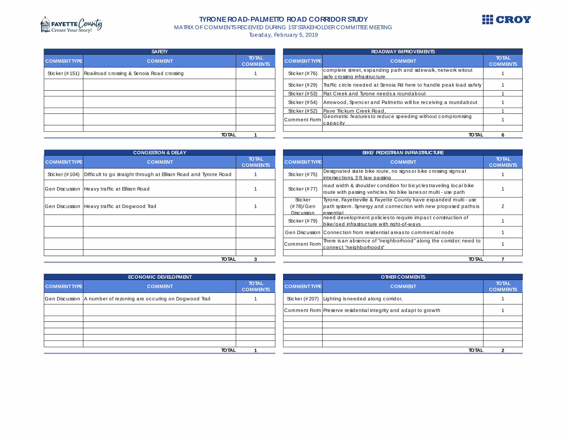
TYRONE ROAD-PALMETTO ROAD CORRIDOR STUDY MATRIX OF COMMENTS RECEIVED DURING 1ST STAKEHOLDER COMMITTEE MEETING
Tuesday, February 5, 2019
COMMENT TYPE COMMENT TOTAL COMMENTS COMMENT TYPE COMMENT TOTAL
COMMENTS
Sticker (#151) Roailroad crossing & Senoia Road crossing 1 Sticker (#76) complete street, expanding path and sidewalk, network witout safe crossing infrastructure
1
Sticker (#29) Traffic circle needed at Senoia Rd here to handle peak load safely 1
Sticker (#53) Flat Creek and Tyrone needs a roundabout 1
Sticker (#54) Arrowood, Spencer and Palmetto will be receiving a roundabout 1
Sticker (#52) Pave Trickum Creek Road, 1
Comment Form Geometric features to reduce speeding without compromising capacity
1
1 6
COMMENT TYPE COMMENT TOTAL COMMENTS COMMENT TYPE COMMENT TOTAL
COMMENTS
Sticker (#104) Difficult to go straight through at Ellison Road and Tyrone Road 1 Sticker (#75) Designated state bike route, no signs or bike crossing signs at intersections, 3 ft law passing
1
Gen Discussion Heavy traffic at Ellison Road 1 Sticker (#77)road width & shoulder condition for bicycles traveling local bike route with passing vehicles. No bike lanes or multi - use path 1
Gen Discussion Heavy traffic at Dogwood Trail 1Sticker
(#78)/Gen Discussion
Tyrone, Fayetteville & Fayette County have expanded multi - use path system. Synergy and connection with new proposed paths is essential
2
Sticker (#79) need development policies to require impact construction of bike/ped infrastructure with right-of-ways
1
Gen Discussion Connection from residential areas to commercial node 1
Comment Form There is an absence of "neighborhood" along the corridor; need to connect "neighborhoods"
1
3 7
COMMENT TYPE COMMENT TOTAL COMMENTS COMMENT TYPE COMMENT TOTAL
COMMENTS
Gen Discussion A number of rezoning are occuring on Dogwood Trail 1 Sticker (#207) Lighting is needed along corridor, 1
Comment Form Preserve residential integrity and adapt to growth 1
1 2
SAFETY ROADWAY IMPROVEMENTS
TOTAL TOTAL
CONGESTION & DELAY BIKE/ PEDESTRIAN INFRASTRUCTURE
TOTAL TOTAL
ECONOMIC DEVELOPMENT OTHER COMMENTS
TOTAL TOTAL
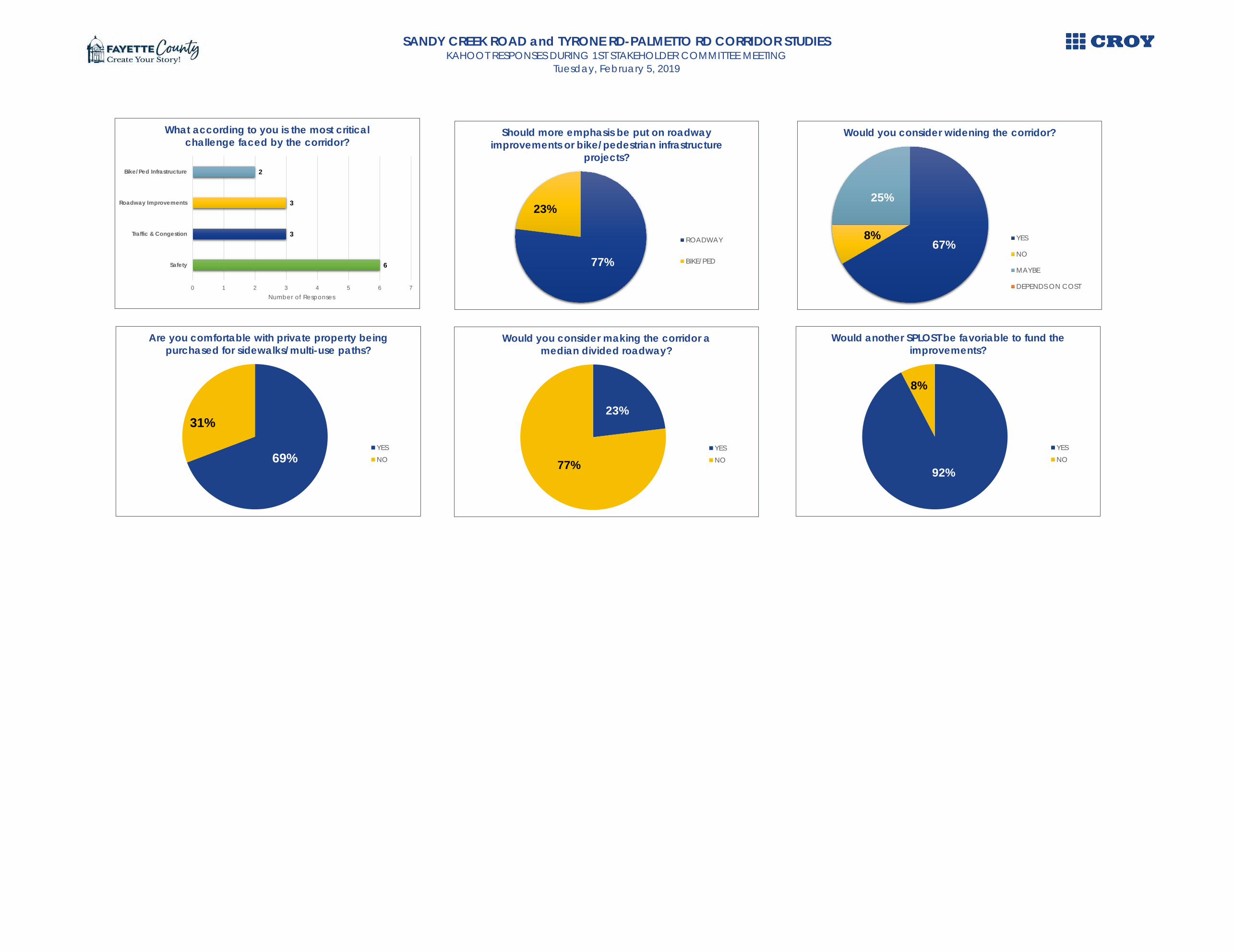
SANDY CREEK ROAD and TYRONE RD-PALMETTO RD CORRIDOR STUDIESKAHOOT RESPONSES DURING 1ST STAKEHOLDER COMMITTEE MEETING
Tuesday, February 5, 2019
6
3
3
2
0 1 2 3 4 5 6 7
Safety
Traffic & Congestion
Roadway Improvements
Bike/Ped Infrastructure
Number of Responses
What according to you is the most critical challenge faced by the corridor?
77%
23%
Should more emphasis be put on roadway improvements or bike/pedestrian infrastructure
projects?
ROADWAY
BIKE/PED
67%8%
25%
Would you consider widening the corridor?
YES
NO
MAYBE
DEPENDS ON COST
69%
31%
Are you comfortable with private property being purchased for sidewalks/multi-use paths?
YESNO
23%
77%
Would you consider making the corridor a median divided roadway?
YESNO
92%
8%
Would another SPLOST be favoriable to fund the improvements?
YESNO

WHAT ARE YOUR PERCEPTIONS OF THE EXISTING CONDITIONS OF THE CORRIDOR?
Fayette County Transportation Corridors Study - Sandy Creek Road
Word Cloud - Response & Frequencywinding 7narrow 7unsafe 5speed 3congestion 3rural 1residential 1turnlanes 1shoulder improvement
1
poor intersections
1
railroad crossing 1sidewalks 1landscaping 1dark 1sight distance 1

WHAT WOULD YOU WANT THE CORRIDOR TO BE?
Fayette County Transportation Corridors Study - Sandy Creek Road
Word Cloud - Response & Frequencyfree flowing 6safe 5accommodating 4bike lanes 2wide lanes 2landscaping 2residential 2sidewalk 2limited access 1shoulder 1speed limit 1no trucks 1complete street 1

APPENDIX B
Stakeholder Committee 2
Meeting Summary

SANDY CREEK ROAD Summary of Comments
The second stakeholder committee meeting for the Sandy Creek Road corridor study was held on May 22, 2019 from 5 pm to 7 pm at the Fayette County Public Library. The stakeholder committee meeting was in conjunction with the other three corridors also being studied by Fayette County.
The meeting was workshop style where committee members and county staff worked on three activities and focused on the draft concepts and their priority.
The first activity was the SWOT Analysis (Strengths, Weakness, Opportunities, Trepidation). The summary of the Sandy Creek Road SWOT is shown below.
The second workshop activity was discussing the draft concepts and prioritizing them. The concepts identified by the committee in rank order are displayed in the graphic below.

The third activity was called “Show me the Money”. To aid further prioritization, each stakeholder was given 1 million dollars in funds to invest in projects. Below is the aggregate for project investment for all stakeholder committee members.

APPENDIX C
Road Safety Audit Summary

Summary of Road Safety Audit Sandy Creek Road
Date: Monday, April 8, 2019 RSA Team and Participants: Phil Mallon (Fayette County Public Works) Joe Robison (Fayette County Public Works) Bradley Klinger (Fayette County Public Works)
Kevin Harpe (GDOT District 3) Jennifer Compton (GDOT District 3) Aimee Turner (Croy Engineering) Dan Dobry (Croy Engineering)
Background: The RSA was conducted on Sandy Creek Road from SR 74/Joel Cowan Parkway to Veterans Parkway. The purpose of this RSA was to located any potential road safety issues and identify opportunities for improvements in safety for all road users. The RSA was administered by Fayette County as part of the overall corridor studies for Sandy Creek Road, Banks Road, Tyrone Road-Palmetto Road, and SR 279.
RSA Process: The RSA was conducted over a half-day period by having the RSA Team observed the corridor and intersections on foot and a windshield survey. In addition, the team also examined crash data and public input responses for the corridor to help identify safety issues or concerns. The field observations and supplemental data was used together to identify roadway countermeasures that will help improve traffic safety.

Major RSA Findings Location(s): @ SR 74/Joel Cowan Parkway Observations/Safety Issues: There are signs that are not applicable at the intersection (i.e. R560-5) and may cause driver confusion. There were discussions of signalized the median U-turn for the RCUT, GDOT would check status of the project. Although there is a northbound acceleration lane for westbound vehicles turning right on SR 74, many vehicles still stop and wait for break in through lane before proceeding. Pavement damage observed on the southeast and northeast corners, possibly from trucks turning. Vegetation was overgrown on Sandy Creek Road heading east.
Location(s): Between SR 74 and Waltham Way Observations/Safety Issues: Rolling hills and there is a significant drop-off on both sides of Sandy Creek Road. Little to no shoulders for the majority of the stretch. There was one fatality from an off roadway crash.
Location(s): Between Waltham Way and Sandy Ridge Road Observations/Safety Issues: Steep shoulders and rolling hills for the majority of section. Little to no shoulders for the majority of the stretch. There were a number of off roadway crashes in this section.
Location(s): @ Sandy Ridge Road Observations/Safety Issues: Sight distance concern looking west from Sandy Ridge Road. Overgrown vegetation east of Sandy Ridge Road needs to be trimmed.
Location(s): @ Coast Line Road Observations/Safety Issues: Location of stop bar on Coast Line Road makes it difficult to see traffic on Sandy Creek Road. Railroad power box obstructs sight distance looking east.
Location(s): @ Ellison Road Observations/Safety Issues: Ellison Road come in at a skew. Substantial number of angle and rear end crashes at intersection. Overgrown vegetation on looking east and west on Sandy Creek Road.
Location(s): @ Coast Line Road Observations/Safety Issues: Jenkins Road comes in at a skew. Complaints of students using Jenkins Road as a cut-through/racing in the afternoon.
Location(s): @ Adams Road Observations/Safety Issues: Poor sight distance looking both directions. Fence in right-of-way on the southeast corner. Horizontal curve east of Adams Road. Substantial number of off-road crashes.
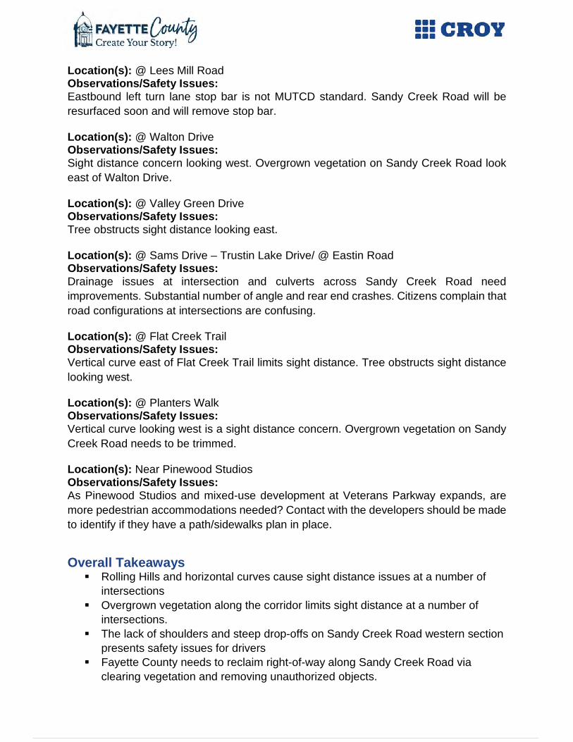
Location(s): @ Lees Mill Road Observations/Safety Issues: Eastbound left turn lane stop bar is not MUTCD standard. Sandy Creek Road will be resurfaced soon and will remove stop bar.
Location(s): @ Walton Drive Observations/Safety Issues: Sight distance concern looking west. Overgrown vegetation on Sandy Creek Road look east of Walton Drive.
Location(s): @ Valley Green Drive Observations/Safety Issues: Tree obstructs sight distance looking east.
Location(s): @ Sams Drive – Trustin Lake Drive/ @ Eastin Road Observations/Safety Issues: Drainage issues at intersection and culverts across Sandy Creek Road need improvements. Substantial number of angle and rear end crashes. Citizens complain that road configurations at intersections are confusing.
Location(s): @ Flat Creek Trail Observations/Safety Issues: Vertical curve east of Flat Creek Trail limits sight distance. Tree obstructs sight distance looking west.
Location(s): @ Planters Walk Observations/Safety Issues: Vertical curve looking west is a sight distance concern. Overgrown vegetation on Sandy Creek Road needs to be trimmed.
Location(s): Near Pinewood Studios Observations/Safety Issues: As Pinewood Studios and mixed-use development at Veterans Parkway expands, are more pedestrian accommodations needed? Contact with the developers should be made to identify if they have a path/sidewalks plan in place.
Overall Takeaways Rolling Hills and horizontal curves cause sight distance issues at a number of
intersections Overgrown vegetation along the corridor limits sight distance at a number of
intersections. The lack of shoulders and steep drop-offs on Sandy Creek Road western section
presents safety issues for drivers Fayette County needs to reclaim right-of-way along Sandy Creek Road via
clearing vegetation and removing unauthorized objects.

Recommendations and Ratings Level of Effort Time Frame Cost Clear overgrown vegetation along Sandy Creek Road Low Short-Term Low
Add shoulders along corridor to make drivers more comfortable Moderate Intermediate High
Flatten road to improve visibility at intersections High Long Term High
At SR 74: Make request to GDOT to perform routine maintenance Low Short-Term Low
At SR 74: Add "Keep Moving" sign for WB right; Add Pavement to accommodate trucks Low Short-Term Low
Between SR 74 and Waltham Way: Identify locations for object markers and guardrail Moderate Short-Term Moderate
At Coast Line Road: Move stop bar Low Short-Term Low At Ellison Road: Realignment and add turn lanes High Intermediate High
At Jenkins Road: Realignment or close Jenkins Road High Intermediate High
East of Adams Road: Add "Curve ahead" and "Chevrons" signs in advance of curve Low Short-Term Low
Correct drainage culverts at Sams Drive-Trustin Lake/Eastin Rd Moderate Intermediate Moderate
Intersection improvement at Sams Dr-Trustin Lake/Eastin Rd HIgh Short-Term High
Legend Level of Effort Time Frame Cost
Low Short Term Low SPLOST/Local Funding 1 to 6 months $0 to $100,000
Moderate Intermediate Moderate Full Construction Plan – Low Impacts 6 to 24 months $100,000 to $300,000
High Long Term High Full Construction Plan – High Impacts Greater than 24 months Greater than $300,000

APPENDIX D
PIOH 1 Flyers and Meeting
Materials


Fayette County Hosting Public Meeting for Study of Four Corridors
Fayette County, Georgia, March 1st, 2019 – You are invited to a public information open house to discuss transportation improvements for the Sandy Creek Road, Tyrone Road-Palmetto Road, Banks Road, and SR 279 corridors on Monday March 18, 2019 from 4 pm to 7 pm.
The meeting will be held at the Fayette County Public Library, 1821 Heritage Park Way, Fayetteville, GA.
With continued growth in the region Fayette County has started the process to identify current and future concerns for providing safe and efficient movement along these corridors. Input received from the public will be used to develop alternative transportation improvements that address existing and projected conditions with the goal of enhancing safety; reducing congestion and delay; facilitating multi-modal usage; and supporting economic development.
“Corridor studies of this nature help Fayette County plan for and construct the appropriate types of improvements to support the varied travel needs of our citizens and business owners. The more public input we receive the better job we can do in providing the desired transportation system,” says Phil Mallon, Fayette County’s Public Works Director.
The open house will be informal and everyone is invited to stop by anytime between 4 pm and 7 pm with plenty of parking available at the Fayette County Public Library. Information provided at the meeting, as well as a survey for each corridor, will be posted on the Fayette County Transportation Planning Webpage (https://www.fayettecountyga.gov/transportation-planning/index.htm). In addition, comment forms will be available at the meeting and online.
For additional information contact Phil Mallon, Fayette County Public Works (770) 320-6010 or Dan Dobry, Croy Engineering (consultant), (770) 971-5401.
###
Issued:
Contact: Tameca P. White, County Clerk
Office: (770) 305-5103
Email: [email protected]
FAYETTE Press Release BOARD OF COMMISSIONERS

This project aims at identifying traffic & transportation solutions from a holistic perspective, to ensure safety, promote economic development, understand prospects for multi-modal uses and create sustainable infrastructure improvements for the citizens. The is a
joint collaboration between Fayette County, Atlanta Regional Commission & Croy Engineering, LLC; also working in partnership with the City of Fayetteville and Town of Tyrone.
Sandy Creek Road Corridor Study
STUDY AREA
STUDY TIMELINE
GET INVOLVED Submit Feedback at :
https://www.surveymonkey.com/r/HB8V2ZF
For more information, visit our webpage:http://www.fayettecountyga.gov/transportation-planning/
Philip Mallon, P.E., Program ManagerFayette County Public Works
Vanessa Birrell, Sandy Creek Road Project Manager,Fayette County Environmental Management Department
Daniel B. Dobry, Jr., P.E., PTOE, AICPCroy Engineering, [email protected]
CONTACT US

TRAFFIC VOLUMES & CRASH DATA
Sandy Creek Road - Crashes Heat Map
LEGENDSandy Creek Road
POTENTIAL IMPROVEMENTS

Fayette County Transportation Corridors Study
SANDY CREEK ROAD
Comment Sheet
Daniel B. Dobry, Jr., P.E., PTOE, AICP Croy Engineering, LLC 200 North Cobb Parkway, Building 400, Suite 413, Marietta, GA 30062 Phone: (770) 971-5407; E-mail: [email protected]
Name
Email Address
(optional if you want to receive updates)
1. What are the current challenges faced by the corridor?
Speeding Trucks
No sidewalks Sharp Curves
Congestion Safety
Other
2. What types of improvements would you like to see along the corridor?
Additional Lanes Bike Lanes
Wider Shoulders Multi – Use Path
Traffic Signals Street Lighting
Other
3. Should non-construction alternatives be considered?
Lower Speed Limit Truck Restriction
Other
4. Should private property be acquired to improve community cohesiveness and aesthetics?
Yes No
5. Other Comments

APPENDIX E
PIOH 1 Summary

Fayette County Transportation Corridors Study
PIOH 1 Results

Corridor Review1

• Tyrone Road - Palmetto Road
• Sandy Creek Road
• Banks Road
• State Route 279
THE CORRIDORS

Existing Conditions Recap2

• Study Limits - Veterans Parkway In Fayetteville To State Route 74 In Tyrone
• Roadway – Two-lane Undivided With Minimal Shoulder
• GDOT Classification – Rural Minor Arterial
• Intersections – 17 Intersections (1 RCUT; 1 Roundabout; No Signalized)
• Bike/Pedestrian Facilities - No Sidewalks Or Bicycle Facilities
• Transit Facilities – No Fixed Route Services
Sandy Creek Road
301
5969
111
0 10 20 30 40 50 60 70 80
ANGLEHEAD ON
NOT A COLLISON WITH MVREAR END
SIDESWIPE-OPPOSITESIDESWIPE-SAME
Number of Crashes
Type
of C
rash
5-Year Crash Data by Type
Top 5 Crash Locations
1. Highway 74 (54 Crashes)
2. Eastin Road (17 Crashes)
3. Lees Mill Road (16 Crashes)
4. Sandy Ridge Trl (11 Crashes)
5. Ellison Road (10 Crashes)

• Study Limits - Tyrone Road From State Route 54 To Senoia Road and Palmetto Road
From Senoia Road To The Coweta County Line
• Roadway – Two-lane Undivided With Shoulder
• GDOT Classification – Rural Minor Arterial
• Intersections – 23 Intersections (2 Signalized)
• Bike/Pedestrian Facilities - No Sidewalks Or Bicycle Facilities (Small Golf Cart Stretch)
• Transit Facilities – No Fixed Route Services
Tyrone Road – Palmetto RoadTop 5 Crash Locations
1. Highway 74 (84 Crashes)
2. Highway 54 (84 Crashes)
3. Flat Creek Trl(20 Crashes)
4. Dogwood Trail (19 Crashes)
5. Adams Road (15 Crashes)
778
80152
111
0 20 40 60 80 100 120 140 160
ANGLEHEAD ON
NOT A COLLISON WITH MVREAR END
SIDESWIPE-OPPOSTITESIDESWIPE-SAME
Number of Crashes
Type
of C
rash
5-Year Crash Data by Type

• Study Limits - Extends From State Route 54 To State Route 314
• Roadway – Two-lane Undivided With Shoulder
• GDOT Classification – Rural Minor Arterial
• Intersections – 15 Intersections (3 Signalized)
• Bike/Pedestrian Facilities - Continuous Sidewalk Along Both Sides From SR 314
To SR 85 After Which Continues On The North Side Only For Approximately 800
Feet. No Sidewalks Or Bicycle Facilities East Of The Banks Station Shopping
Center
• Transit Facilities – No Fixed Route Services
Banks RoadTop 5 Crash Locations
1. Highway 85 (131 Crashes)
2. Highway 54 (72 Crashes)
3. Highway 314 (56 Crashes)
4. Deer Forest Trail (23 Crashes)
5. Ellis Road (20 Crashes)
12711
42162
226
0 50 100 150 200
ANGLEHEAD ON
NOT A COLLISON WITH MVREAR END
SIDESWIPE-OPPOSITESIDESWIPE-SAME
Number of Crashes
Type
of C
rash
5-Year Crash Data by Type

• Study Limits - Extends From Corinth Road To The Fulton/Fayette County Border
• Roadway – Two-lane Undivided With Shoulder
• GDOT Classification – Rural Minor Arterial
• Intersections – 18 Intersections (2 Signalized)
State Route 279Top 5 Crash Locations
1. Highway 85 (95 Crashes)
2. Highway 314 (95 Crashes)
3. Dix Lee On Drive(31 Crashes)
4. Helmer Road (30 Crashes)
5. Lafayette Drive(25 Crashes)
• Bike/Pedestrian Facilities - No
Sidewalks Or Bicycle Facilities
• Transit Facilities – No Fixed Route
Services
• Planned Improvements – SR 279 at
SR 85 Intersection Improvements
(GDOT) and SR 279 and Corinth
Road Realignment Study
768
48241
723
0 50 100 150 200 250 300
ANGLEHEAD ON
NOT A COLLISON WITH MVREAR END
SIDESWIPE-OPPOSITESIDESWIPE-SAME
Number of Crashes
Type
of C
rash
5-Year Crash Data by Type

Public Open House Recap3

10
FAYETTE COUNTY CORRIDOR STUDYPUBLIC INFORMATION OPEN HOUSE: MARCH 18, 2019
TOTAL NUMBER OF PARTICIPANTS = 195
BANKS ROAD STATE ROUTE 279COMMENT
CARDCOMMENT
SHEET WORD CLOUD COMMENT CARD
COMMENT SHEET WORD CLOUD
80 46 30 31 9 12
Total Comments 156 Total Comments 52
SANDY CREEK ROAD TYRONE ROAD - PALMETTO ROAD COMMENT
CARDCOMMENT
SHEET WORD CLOUD COMMENT CARD
COMMENT SHEET WORD CLOUD
61 16 8 30 4 7
Total Comments 85 Total Comments 41
TOTAL NUMBER OF COMMENTS = 334

Sandy Creek Road
1111
22222222
333
45
616
0 2 4 6 8 10 12 14 16 18
JENKINS & SANDY CREEK
LAKE ROAD & SANDY CREEK
SAMS & SANDY CREEK
VETERANS PKWY & LEES MILL
ADAMS ROAD
FLAT CREEK TRL & SANDY CREEK
LAKE ROAD
SAMS DRIVE & LEES MILL
VETERANS PARKWAY
VETERANS PARKWAY & 85
VETERANS PKWY & SANDY CREEK
WALTON DRIVE & SANDY CREEK
EASTIN ROAD & SANDY CREEK
TRUSTIN, SAMS, EASTIN & SANDY CREEK
VETERANS PKWY & 92
ELLISON & SANDY CREEK
ADAMS & SANDY CREEK
HWY 74 & SANDY CREEK
SANDY CREEK ROAD
COMMENT LOCATION
1122233
555
66
823
0 5 10 15 20 25
ACCESSIBILITY LANDSCAPING
CHARACTER MAINTAINED/ NO NEW …LIGHTING
ZONINGSHARP CURVE
TRAFFIC SIGNAL 18-WHEELERS
BIKE PED INFRASTRUCTURESIGHT DISTANCE
CONGESTIONSPEEDING
TRAFFIC CALMINGROADWAY IMPROVEMENTS
COMMENT CATEGORY

Sandy Creek Road
20%
4%
13%
15%15%
18%
15%
What Are The Current Challenges Faced By The Corridor?
Speeding
No sidewalks
Congestion
Trucks
Sharp Curves
Safety
Other
8%
22%
11%7%11%
11%
30%
What Types Of Improvements Would You Like To See Along The Corridor?
Additional LanesWider ShouldersTraffic SignalsBike LanesMulti – Use PathStreet LightingOther
1
9
6
LOWER SPEED LIMIT
TRUCK RESTRICTION
OTHER
0 1 2 3 4 5 6 7 8 9 10
Should Non-construction Alternatives Be Considered?
3
5
YES
NO
0 1 2 3 4 5 6
Should Private Property Be Acquired To Improve Community Cohesiveness And Aesthetics?

Tyrone Road – Palmetto Road
11
22
45
810
1112
0 2 4 6 8 10 12 14
BIKE - PED INFRASTRUCTURELITTERINGSIGNAGE
TRAFFIC SIGNAL18-WHEELERS
SPEEDINGTRAFFIC CALMING
ROUNDABOUTROADWAY IMPROVEMENTS
CONGESTION
COMMENT CATEGORY
11111
22
33333
46
8
0 1 2 3 4 5 6 7 8 9
LINCOLN & PALMETTOLINCOLN ROAD
OLD SENOIA & TYRONEPALMETTO & ARROWOOD
DOGWOOD TRAILSENOIA & TYRONE
BRIARWOOD & PALMETTOTYRONE ROAD
FARR ROAD & TYRONE ROADFARR ROAD
DOGWOOD TRAIL & FARR ROAD ADAMS ROAD
ELLISON & TYRONEDOGWOOD TRAIL & TYRONEFLAT CREEK TRAIL & TYRONE
COMMENT LOCATIONS

9%
18%
28%9%
27%
9%
What Are The Current Challenges Faced By The Corridor?
Speeding
No sidewalks
Congestion
Trucks
Safety
Other
Tyrone Road – Palmetto Road
11%11%
11%
34%
33%
What Types Of Improvements Would You Like To See Along The Corridor?
Additional Lanes
Wider Shoulders
Bike Lanes
Multi – Use Path
Other
0
1
1
LOWER SPEED LIMIT
TRUCK RESTRICTION
OTHER
0 0.2 0.4 0.6 0.8 1 1.2
Should Non-construction Alternatives Be Considered?
3
0
YES
NO
0 0.5 1 1.5 2 2.5 3 3.5
Should Private Property Be Acquired To Improve Community Cohesiveness And Aesthetics?

Banks Road
111122233
45
67
89
1720
2328
0 5 10 15 20 25 30
CRASHESPARKS & REC
SAFETYSTANDING WATER
LANDSCAPING TRAFFIC MOVEMENT
ZONING18-WHEELERS
SIGHT DISTANCESIGNAGE
CHARACTER MAINAINED/ NO WIDENINGROUNDABOUT
LESS THRU - TRAFFICLIGHTING
CONGESTIONSPEEDING
TRAFFIC SIGNALBIKE PED INFRASTRUCTURE
ROADWAY IMPROVEMENTS
COMMENT CATEGORY
1
1
1
1
1
1
2
2
2
2
3
3
3
7
7
8
26
61
0 10 20 30 40 50 60 70
PONDEROSA TRCE
ELLIS RD
HOLLY HILL ROAD & BANKS
SR 54
SR 85 & ELLIS
VAUGHN DRIVE & BANKS
HIDDEN VALLEY RD
SMOKEMONT & BANKS
SR 54 & MC ELROY ROAD
SR 85 & BANKS
ALLENWOOD RD
DEER FOREST TRAIL & BANKS
DEER TRAIL ROAD
DEER FOREST TRAIL
PONDEROSA TRCE & BANKS
SR 54 & BANKS
ELLIS & BANKS
BANKS ROAD
COMMENT LOCATIONS

Banks Road
23%
20%
13%13%
7%
17%
7%
What Are The Current Challenges Faced By The Corridor?
SpeedingNo sidewalksCongestionTrucksSharp CurvesSafetyOther
7%12%
18%
8%15%
21%
19%
What Types Of Improvements Would You Like To See Along The Corridor?
Additional LanesWider ShouldersTraffic SignalsBike LanesMulti – Use PathStreet LightingOther
15
29
7
LOWER SPEED LIMIT
TRUCK RESTRICTION
OTHER
0 5 10 15 20 25 30 35
Should Non-construction Alternatives Be Considered?
11
25
YES
NO
0 5 10 15 20 25 30
Should Private Property Be Acquired To Improve Community Cohesiveness And Aesthetics?

SR 279
1
1
1
1
1
1
2
2
4
5
19
0 5 10 15 20
18-WHEELERS
LIGHTING
PARKING
SPEEDING
TRAFFIC CALMING
VERTICAL SIGHT DISTANCE
BIKE PED INFRASTRUCTURE
SIGNAGE
TRAFFIC SIGNAL
CONGESTION
ROADWAY IMPROVEMENTS
COMMENT CATEGORY
1
1
1
1
1
1
1
1
1
1
1
1
2
2
3
3
3
4
0 0.5 1 1.5 2 2.5 3 3.5 4 4.5
MITCHELL ROAD
NORTH DRIVE
GODBY ROAD
AUSTIN DRIVE & 279
COUNTRY LAKE & 279
DIX LEE ON, NORTH DRIVE, COUNTRY LAKE …
MAYFAIR LANE & 279
OLD FORD ROAD & 279
OUR LADY OF MERCY HIGH SCHOOL & 279
KENWOOD ROAD & 314
S.R. 279 FROM 138 - 85
279, SOUTH OF HELMER ROAD
S.R. 279 FROM 314 - 138
S.R. 314 & 279
HELMER ROAD & 279
MCKOWN ST & 279
S.R. 85 & 279
S.R. 279
COMMENT LOCATION

SR 279
7%
46%
7%
40%
What Are The Current Challenges Faced By The Corridor?
Speeding
Congestion
Sharp Curves
Other
33%
17%5%
5%
6%
6%
28%
What Types Of Improvements Would You Like To See Along The Corridor?
Additional LanesWider ShouldersTraffic SignalsBike Lanes
Multi – Use PathStreet LightingOther
1
1
0
LOWER SPEED LIMIT
TRUCK RESTRICTION
OTHER
0 0.2 0.4 0.6 0.8 1 1.2
Should Non-construction Alternatives Be Considered?
2
5
YES
NO
0 1 2 3 4 5 6
Should Private Property Be Acquired To Improve Community Cohesiveness And Aesthetics?

Road Safety Audit Recap4
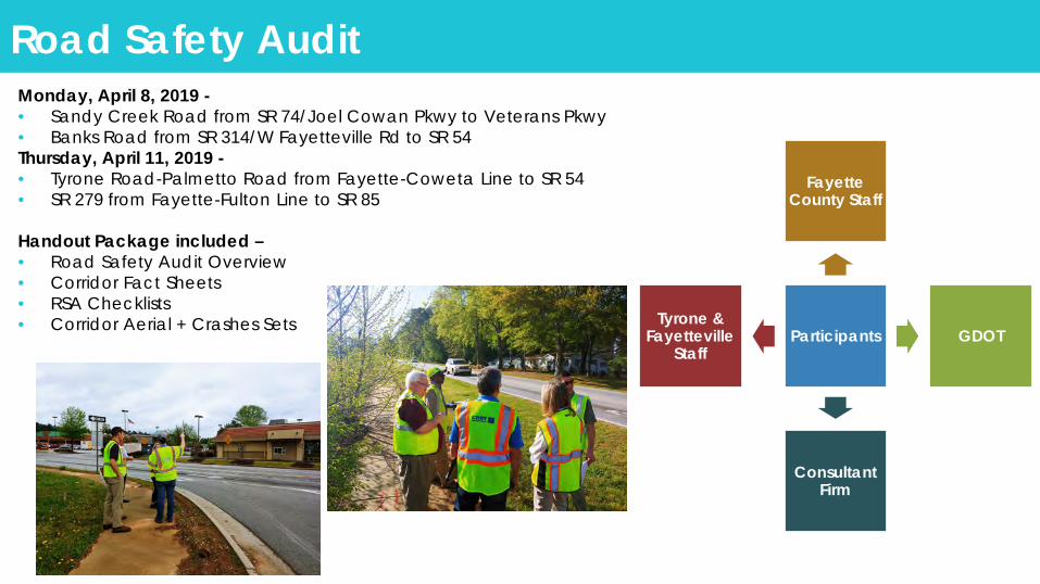
Road Safety Audit
Participants
Fayette County Staff
GDOT
Consultant Firm
Tyrone & Fayetteville
Staff
Monday, April 8, 2019 -• Sandy Creek Road from SR 74/Joel Cowan Pkwy to Veterans Pkwy• Banks Road from SR 314/W Fayetteville Rd to SR 54Thursday, April 11, 2019 -• Tyrone Road-Palmetto Road from Fayette-Coweta Line to SR 54• SR 279 from Fayette-Fulton Line to SR 85
Handout Package included –• Road Safety Audit Overview• Corridor Fact Sheets• RSA Checklists• Corridor Aerial + Crashes Sets

APPENDIX F
PIOH 2 Flyers and Meeting
Materials

For More Informationcall us on 770-320-6010
or visit us athttp://www.fayettecountyga.gov/transportation-planning/
Fayette County Transportation Corridor Studies
Sandy Creek Road
Banks Road
Tyrone- Palmetto Road
State Route 279
Monday, July 15th, 2019
4:00 - 7:00 PM
Fayette County Library1821 Heritage Pkwy, Fayetteville, GA 30214
Please Join Us At The Public Open House
Help Prioritize ProjectsCITIZEN INPUT IS CRITICAL

Fayette County Hosting Public Meeting for Study of Four Corridors
Fayette County, Georgia, June 25, 2019 – You are invited to a public information open house to discuss transportation improvement draft concepts for the Sandy Creek Road, Tyrone Road-Palmetto Road, Banks Road, and SR 279 corridors on Monday July 15, 2019 from 4 pm to 7 pm.
The meeting will be held at the Fayette County Public Library, 1821 Heritage Park Way, Fayetteville, GA.
With continued growth in the region, Fayette County had initiated the process to identify current and future concerns for providing safe and efficient movement along these corridors. Input received from stakeholders and the public were used to develop draft concepts to facilitate transportation improvements that address existing and projected conditions with the goal of enhancing safety; reducing congestion and delay; facilitating multi-modal usage; and supporting economic development.
“Corridor studies of this nature help Fayette County plan for and construct the appropriate types of improvements to support the varied travel needs of our citizens and business owners. The more public input we receive the better job we can do in providing the desired transportation system,” says Phil Mallon, Fayette County’s Public Works Director.
The open house will be informal and everyone is invited to stop by anytime between 4 pm and 7 pm with plenty of parking available at the Fayette County Public Library. Draft concepts displayed at the meeting, as well as a survey for each corridor, will be posted on the Fayette County Transportation Planning Webpage (https://www.fayettecountyga.gov/transportation-planning/index.htm). In addition, comment forms will be available at the meeting and online.
For additional information contact Phil Mallon, Fayette County Public Works (770) 320-6010 or Dan Dobry, Croy Engineering (consultant), (770) 971-5401.
###
Contact: Tameca P. White, County Clerk
Office: (770) 305-5103
Email: [email protected]
FAYETTE Press Release BOARD OF COMMISSIONERS

Help Prioritize ProjectsCITIZEN INPUT IS CRITICAL
Fayette County Transportation Corridor Studies
Concepts Benefits Do you think this concept would benefit the corridor?
Rank the concept on a scale of 1 to 5, 5 being the most suited.
1. Realign Ellison Road Intersection + Add Turn Lanes
OperationsSafety
Yes No
2. Remove Jenkins Road Direct Access To Sandy Creek Road
Access MgmtSafety
Yes No
3. Install Roundabout At Sams Dr-Trustin Lake-Eastin Rd
OperationsSafety
Yes No
4. Realign Flat Creek Trail Intersection + Add Turn Lanes
OperationsSafety
Yes No
5. Hawk Signal Near Pinewood Studios
Bike/Ped Yes No
6. Add Shoulders Along Entire Corridor
Safety Yes No
7. Other: Yes No
8. Other: Yes No
SANDY CREEK ROAD CORRIDOR
Additional Comments:
For more information! Visit www.fayettecountyga.gov/transportation-planning/sandy-creek-corridor-study.htm
Prefer to leave feedback online? Visit www.surveymonkey.com/r/sandycreekroad

All feedback on Concepts must be received by Friday, August 2nd, 2019. Comment forms can be dropped off at Fayette County Public Library or mailed to Croy Engineering, 200 N Cobb Parkway, Ste 413, Marietta, Georgia 30062
SANDY CREEK ROAD POTENTIAL IMPROVEMENTS CONCEPT DESIGNS
1: REALIGN SANDY CREEK ROAD AT ELLISON ROAD 4: REALIGN FLAT CREEK TRAIL AT SANDY CREEK ROAD
2: CUL-DE-SAC JENKINS ROAD ACCESS TO SANDY CREEK ROAD 5: HAWK SIGNAL NEAR PINEWOOD STUDIOS CAMPUS
3: ROUNDABOUT AT EASTIN ROAD-SAMS DRIVE-TRUSTIN LAKE DRIVE 6: ADD SHOULDER ALONG SANDY CREEK ROAD

SANDY CREEK ROADPOTENTIAL IMPROVEMENTS INFORMATION
For more information! Visit www.fayettecountyga.gov/transportation-planning/sandy-creek-corridor-study.htm
Prefer to leave feedback online? Visit www.surveymonkey.com/r/sandycreekroad
Sandy Creek Road At Eastin Rd - Sams Dr - Trustin Lake Dr• Average No. Crashes Per Year - 25*• 2018 LOS (AM/PM) - B/B
Install Roundabout• Time Frame: 3 - 5 years• Benefits: Safety, Operations• Cost: $$$$
Proposed Improvements -
Notes: LOS - Levels of Service. Qualitative measure to rate quality of traffic flow based on perfromance measures such as vehicle speed density, congestion, etc. The rating is from A to F. A = good; F = failLegend: $ < $250,000 $$ < $500,000 $$$ < $1,000,000 $$$$ < $2,000,000 $$$$$ < $5,000,000
* crash frequency higher than state average
Sandy Creek Road At Flat Creek Trail• Average No. Crashes Per Year - 0.6• 2018 LOS (AM/PM) - B/B
Realign Intersection, Add Turn Lanes• Time Frame: 3 - 5 years• Benefits: Safety, Operations• Cost: $$$
Proposed Improvements -
Sandy Creek Road Near Veterans Parkway• Average No. Crashes Per Year - 3• 2018 LOS (AM/PM) - B/B
HAWK Signal near Pinewood Studios• Time Frame: 1 year• Benefits: Bike - Pedestrian• Cost: $
Proposed Improvements -
Sandy Creek Road: Entire Corridor• Average No. Crashes Per Year - 34.2• 2018 LOS (AM/PM) - B/B
Add Shoulders Along Entire Corridor• Time Frame: 3 - 5 years• Benefits: Safety• Cost: $$$$$
Proposed Improvements -
Sandy Creek Road At Ellison Road• Average No. Crashes Per Year - 2.0• 2018 LOS (AM/PM) - D/C
Realign Intersection, Add Turn Lanes• Time Frame: 3 - 5 years• Benefits: Safety, Operations• Cost: $$$
Proposed Improvements -
Sandy Creek Road At Jenkins Road• Average No. Crashes Per Year - 1.4• 2018 LOS (AM/PM) - B/B
Cul-de-sac Jenkins Road Access• Time Frame: 1 - 2 years• Benefits: Access Management• Cost: $$
Proposed Improvements -

APPENDIX G
PIOH 2 Summary

PIOH 2 RESULTS: SANDY CREEK ROAD
48
26
50
44
26
37
6
14
10
11
20
13
REALIGN SANDY CREEK AT ELLISON ROAD
CUL-DE-SAC JENKINS ROAD ACCESS TO SANDY CREEK ROAD
ROUNDABOUT AT EASTIN ROAD - SAMS DRIVE -TRUSTIN LAKE DRIVE
REALIGN FLAT CREEK TRAIL AT SANDY CREEK ROAD
HAWK SIGNAL NEAR PINEWOOD STUDIOS CAMPUS
ADD SHOULDER ALONG SANDY CREEK ROAD
Sticker Station Responses
YES NO

PIOH 2 RESULTS: SANDY CREEK ROAD
35
28
37
34
26
35
6
11
5
3
13
9
REALIGN SANDY CREEK AT ELLISON ROAD
CUL-DE-SAC JENKINS ROAD ACCESS TO SANDY CREEK ROAD
ROUNDABOUT AT EASTIN ROAD - SAMS DRIVE -TRUSTIN LAKE DRIVE
REALIGN FLAT CREEK TRAIL AT SANDY CREEK ROAD
HAWK SIGNAL NEAR PINEWOOD STUDIOS CAMPUS
ADD SHOULDER ALONG SANDY CREEK ROAD
Comment Form Responses
YES NO

APPENDIX H
Online Survey Summary

ONLINE SURVEY COMMENTS: SANDY CREEK ROAD
• Realign Sandy Creek Road at Ellison Road
1. Love the idea to add safety. Think a four way stop would be ideal.
2. Not sure this is broken now....it looks like a solution in search of a problem.
3. This would help with school time traffic. This would help with traffic that is unable
to make a left turn on at Hwy 74/Sandy Creek rd. Due to the change at that
intersection
4. bad design
5. have turning lane for north bound traffic to make the left turn onto Ellison
6. I like that this creates an easier angle for turning between these two roads.
7. The present acute angle of the intersection makes it difficult to see Sandy Creek
Road traffic from the stop sign at the end of Ellison. The problem has always been
compounded by drivers who don't set their turn signals to announce their
intentions. Adding turn lanes will clarify drivers' intentions. l I applaud this plan.
8. A roundabout would be better!
9. I like to eliminate blind spots, but not my highest priority.
10. Waste of money
11%5%
18%
42%
24%
Rank the "Realign Sandy Creek Road at Ellison Road"
Dislike Extremely
Dislike Very Much
Neither Like nor Dislike
Like Very Much
Like Extremely
ONLINE SURVEY COMMENTS: SANDY CREEK ROAD
11. I live near this road; visibility is not good as road presently sits. This would be
advantageous to students driving this way to school and all others
12. It would elevate the wait in traffic going straight. I would suggest adding more
lighting at the intersection.
13. A fix to the blind curve before the west bound Sandy Creek and Adams Rd
intersection should have a higher priority than the Ellison Rd intersection which is
not a dangerous situation.
14. Add cart path
15. Safety should be the deciding factor.
16. Very dangerous intersection.
17. This concept would make this intersection much safer. I travel this area daily, and
have nearly been hit multiple times by people cutting the turn to tight, and from
people flying too fast coming from the railroad tracks which you cannot see people
coming over the railroad very well.
18. That looks a lot safer!
19. Seems wasteful
20. A red light there during the school year would be helpful. The turn lanes are a
great idea until the person turning left pulls up to far and the people in the right
can’t see to turn! This intersection is a huge issue during the school year!
21. I go through the current intersection regularly and there is no reason to update for
safety or traffic.
22. Is a traffic light or 3 way stop going to be needed at this location eventually?
23. No passing lane in front of my house there is a hill and blind spot to be considered.
Residents have a hard time getting in and out of driveways. This will increase
speeding drivers are rude and ride your tail even when turn signals are on (get out
of my way) Consider school safety and ambulances. Route trucks to use Veterans
Parkway. We were here before Pinewood and their investors got the tax break and
now our taxes went up.
24. The proposed intersection is better than what we have now. Have you considered
visibility issues when cars are in both turning lanes? It might be difficult for a
driver to attempting to make a turn from the right lane to see vehicles coming from

ONLINE SURVEY COMMENTS: SANDY CREEK ROAD
the left side, if a vehicle is in the left turn lane, and vice versa. What about a round
about?
25. This e listing intersection is a difficult angle
26. This is better than what is there. How do we account for visibility when cars are in
both turning lanes? It will be difficult to make a turn from the right lane if another
car is in the left lane attempting to turn left, and vice versa. What about a round-
about?
ONLINE SURVEY COMMENTS: SANDY CREEK ROAD
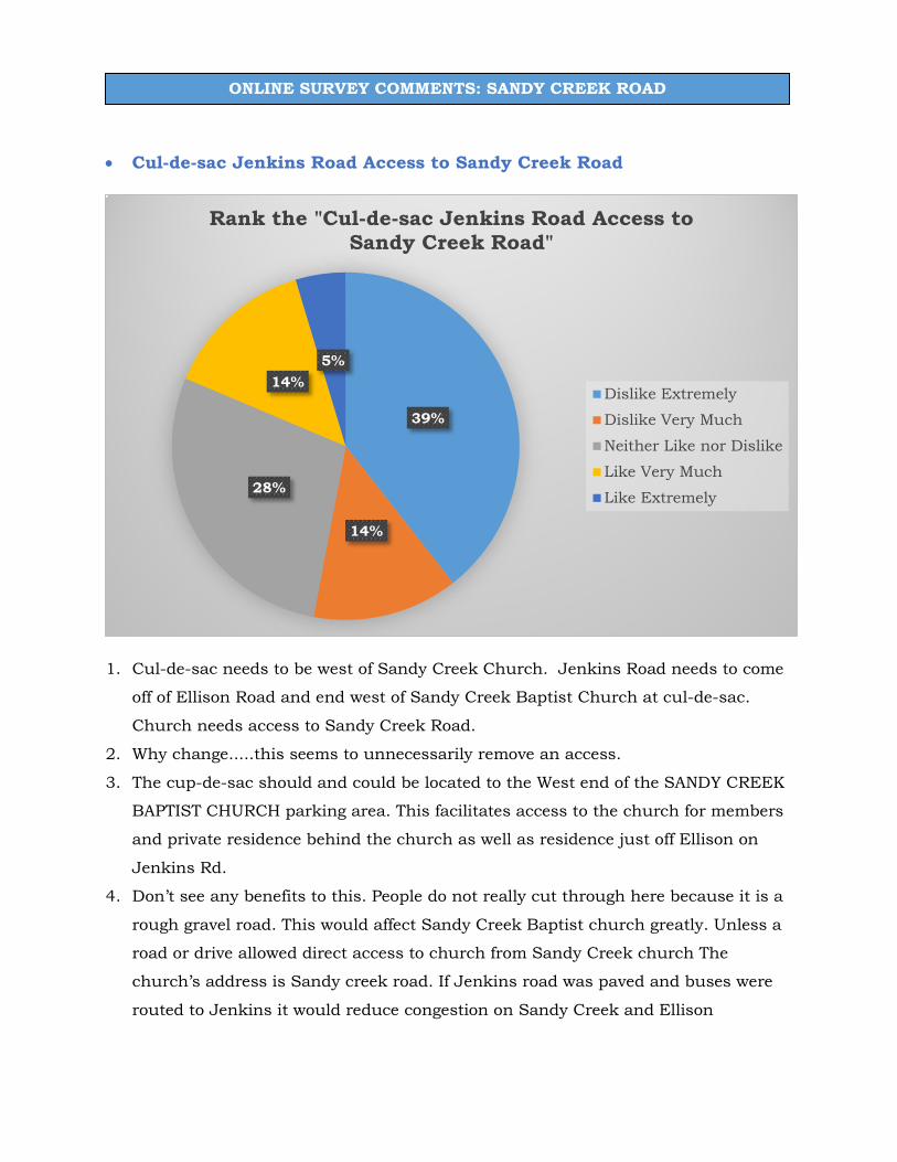
• Cul-de-sac Jenkins Road Access to Sandy Creek Road
1. Cul-de-sac needs to be west of Sandy Creek Church. Jenkins Road needs to come
off of Ellison Road and end west of Sandy Creek Baptist Church at cul-de-sac.
Church needs access to Sandy Creek Road.
2. Why change.....this seems to unnecessarily remove an access.
3. The cup-de-sac should and could be located to the West end of the SANDY CREEK
BAPTIST CHURCH parking area. This facilitates access to the church for members
and private residence behind the church as well as residence just off Ellison on
Jenkins Rd.
4. Don’t see any benefits to this. People do not really cut through here because it is a
rough gravel road. This would affect Sandy Creek Baptist church greatly. Unless a
road or drive allowed direct access to church from Sandy Creek church The
church’s address is Sandy creek road. If Jenkins road was paved and buses were
routed to Jenkins it would reduce congestion on Sandy Creek and Ellison
39%
14%
28%
14%5%
Rank the "Cul-de-sac Jenkins Road Access to Sandy Creek Road"
Dislike Extremely
Dislike Very Much
Neither Like nor Dislike
Like Very Much
Like Extremely
ONLINE SURVEY COMMENTS: SANDY CREEK ROAD
intersection. A turn lane would definitely help flow on Sandy Creek Rd and on
Ellison Road.
5. the church needs access just like the others on the other side of Jenkins near 74
6. Please do not act on this option! This would block off easy access to Sandy Creek
Baptist Church which has been there since 1882 as well as making them change
their address, which also is tied to Sandy Creek. The church adds only slightly to
traffic onto Sandy Creek Road and most of it is on Sunday when traffic is very
light. A better idea to cut through traffic would be to either put the cul-de-sac on
the other end of Jenkins or block the road at the boundary of the church's property
line near the middle of Jenkins between Sandy Creek or Ellison.
7. I am not sure I understand the reasoning behind this proposal. I wonder how
members of Sandy Creek Baptist will respond. Let me add here that the gravel-
road portion of Jenkins has been an ongoing problem. Yes, it is being used as a
cut-through, and traffic produces washboard rutting faster than county
maintenance can grade it as needed. The condition of the road has been an irritant
for homeowners on this stretch, and a cause of accidents as drivers lose control,
impacting trees and mailboxes. County should either get serious about this
stretch of Jenkins and PAVE it, OR consider making it a dead-end at the Ellison
end, allowing access for homeowners and churchgoers and eliminating drive-
through altogether. This change, in concert with the proposed improvement at
Ellison and Sandy Creek, might work well.
8. The concern here is that this would cut off the main access to Sandy Creek Baptist
Church. Entering Jenkins Road via Ellison is not feasible and may cause more
safety and traffic issues for the residents who live there. My recommendation is
that the cul-de-sac be created at Jenkins Road and Ellison since there is a
dangerous turn at that end of the road. This would achieve the same goal of
eliminating the cut through traffic and still maintain the main access to Sandy
Creek Baptist Church
9. This would accomplish almost nothing and is a waste of tax payer money.
Furthermore, it would creat a significant restriction to those that attend the nearby
church.
10. It would take more gas and energy to go past the church then backtrack

ONLINE SURVEY COMMENTS: SANDY CREEK ROAD
11. Jenkins road should be used as primary route off of Sandy Creek Rd to 74. That
way you can use the bridge across the r/r and it runs in to 74 at and existing light.
You could still leave Sandy Creek Rd. As a route to 74 north.
12. This will create a huge problem for school buses, parents and students that easily
access Jenkins Road directly from Sandy Creek Road. The idea is not a good one.
13. Contact Google to remove this road on their grid - to reduce traffic.
14. Not a high priority
15. This would have a very negative impact on Sandy Creek Church. Also a waste of
money
16. This limits our access to Sandy Creek Baptist Church from Fayetteville. This
would be extremely inconvenient for us.
17. This would hurt church growth due to accessibility.
18. I would prefer that they pave the road to make it more accessible.
19. Please do not block sandy creek entrance to SC Baptist.
20. Need to emery vehicle access of Sandy creek
21. Would not like Jenkins to end in a cul-de-sac.
22. Impacts Sandy Creek Baptist Church significantly with a change of address and
closing off an entrance/exit to the church. You should leave a historic church
property of 125 years as is.
23. This cul-de-sac would force increased traffic at the Jenkins Rd and Ellison Rd
intersection which is already a very bad intersection with poor visibility. Not
allowing church goers from Sandy Creek Baptist Church to continue having access
onto Sandy Creek as happens under the currently existing roads/road structure
would definitely force those people to use a more dangerous route of travel from the
church - to get to either Sandy Creek Rd OR Ellison Rd. The existing road usage
is already far safer than the proposed cul-de-sac. The poor road condition of the
"gravel" part of Jenkins Rd already limits cut through traffic volume. The access
management the proposal claims to improve along Sandy Creek seems a minimal
claim of improvement. It would INCREASE the access management at Jenkins and
Ellison. (The cul-de-sac might even encourage a "meeting" spot or hang out spot
detrimental to the safety of all in the area...) Bottom line, why change the current

ONLINE SURVEY COMMENTS: SANDY CREEK ROAD
and safer option(s) to a more restrictive and LESS safe option? Why "fix" what is
NOT broken?
24. I don't know why this is included in the plan because the impact is very low.
25. Does this option include upgrading the pavement of Jenkins Road in this area? It
currently is not paved and degrades significantly annually after rains etc.
26. Add cart path
27. This would place a tremendous burden on Sandy Springs Baptist Church. First, a
cul de sac would eliminate all of the parking in the upper parking lot. There are
two cemetaries (one on each side of Jenkins Rd) so you can not have the cul de sac
toward the side. This would mean that all parking would be down a hill, creating
problems for the predominately elderly members. This would also mean all
stationary would need to be replaced because of the new address on Jenkins Road
in Tyrone instead of the present address on Sandy Creek Rd in Fayetteville. The
church would be hidden on the cul de sac. It would not make sense to leave the
church sign where it is presently on Sandy Creek Road. The cul de sac would
decrease the amount of traffic on Jenkins Rd in front of the church, but would
greatly increase traffic on Ellison Rd. The intersection of Jenkins and Ellison is a
very dangerous intersection, not being able to see oncoming traffic on Ellison.
Instead of making this entire area safer, you would, in fact, make it more
dangerous.
28. I use this route regularly and so do many citizens leaving the schools on Jenkins.
29. This cuts the church and residents off of access to Sandy Creek Road causing a
ridiculous and very unhandy access. It would be much more sensible to curve
between the West cemetery and the Sandy Creek Church sign as was previously
planned.
30. This does not allow easy accessibility to Sandy Creek Baptist Church from the
main road being Sandy Creek Road. If a cul-de- sac is needed, do it from Jenkins
Road to Ellison Road. That end of the road is residential. People use it as a short
cut to Sandy Creek Road. Please do not impede the traffic accessibility to the
church.
31. This cuts the church and residents off of access to Sandy Creek Road causing a
ridiculous and very unhandy access. It would be much more sensible to curve

ONLINE SURVEY COMMENTS: SANDY CREEK ROAD
between the West cemetery and the Sandy Creek Church sign as was previously
planned.
32. This proposal makes no sense to me. You're completely eliminating the primary
entrance to a church and two residences and forcing the use of the
Jenkins/Ellison intersection which is from a driver's viewpoint.
33. As a member of Sandy Creek Baptist Church, this change would cut off access to
most of our members from Sandy creek road, and would increase the traffic on
Jenkins road from Ellison road. Pinewwod Studios often uses our parking lots for
staging film trailers and equipment as well. Tis would either result in Pinewoods
having to find another area to stage for movie production in the area, or would
greatly increase the traffic on Jenkins road as Movie trailers and vehicles would be
moving back and forth frequently. Car pool riders in the area also use our parking
lot, as it has security cameras and provides a safe place for commuters to park for
carpooling. Shutting off access to Sandy Creek would either require them to find an
alternate place to park for carpooling, or increase traffic on Jenkins road. As an
Engineer with The Federal Department of Transportation, Closing off the access to
Sandy Creek Road would also mandate that all of Jenkins road be paved, which is
not depicted. It does not appear much thought to impacts has been given to this
concept. This also appears to be one that could lead to costly legal actions and law
suits against the county due to the negative impacts on the church and the
community.
34. Agree that through traffic is hazardous at Sandy Creek but location of cut-de-sac
should be located nearer to Ellison Road.
35. Either culdesac at end of church property mid Jenkins or end of Jenkins and Ellis.
It would be an extreme hardship on the church to have to travel Jenkins to get to
the church that is not paved.
36. Eliminate present skew at Jenkins/ Sandy Creek instead of cul de sac. Pave
Jenkins from Ellison to Dandy Creek. There is nit heavy cut through traffic on this
strip. The proposal extremely limits access to the historic church and
inconveniences needlessly with no real traffic benefits those church members east
of the church location.

ONLINE SURVEY COMMENTS: SANDY CREEK ROAD
37. I like the cul-de-sac but need to move it up so church has access off Sandy Creek
Rd.
38. I recommend the cul de sac be placed between church parking lot and after last
residential lot. The church would suffer an extreme hardship if the other proposal
is completed.
39. I'm a member of Sandy Creek Baptist Church. This would negatively impact our
church's access and public visibility.
40. It cuts off the church from a main through road. It also pushes a lot of traffic to the
Jenkins-Ellison intersection which is dangerous. A better solution is to move the
cul-de-sac to the other end of the church parking lots near the houses and create a
private drive for the church and the two houses.
41. Newcomers to the church, not knowing the way around by Ellison Road could be
slowing or stopping on Sandy Creek trying to figure out how to access the church.
That situation would likely cause accidents.
42. This change will place an incredible hardship to the church located nearest the
proposed cul-de-sac. You will also be continuing to put the remaining traffic usage
of Jenkins Rd at great risk due to the unsafe conditions of the intersection of
Jenkins Rd. and Ellison. I understand safety concerns are a priority but I hope
you will contemplate restricting greatly the access to church that has been a part
of the community since 1882 and holds the address of 1082 Sandy Creek Road.
43. This concept restricts access to the church and causes a waste of Gas
44. This concept will force large volume Church Traffic out the intersection of Jenkins
and Ellison. This intersection is already skewed and dangerous due to visibility
concerns. It sems mopre appropriate to straighten the church access to Sandy
Creek and control it. If Jenkins Road needs to be eliminated as a cut through,
then perhaps the cul-de-sac should be placed prior to Sandy Creek Baptist on
Jenkins Road with a private drive access from the new Cul-deSac to the church.
This could be gated and only open during services. This would eliminate the cut
through, allow church traffic to exit and enter from both locations, and eliminate
the need for address changes for Sandy Creek Baptist and surrounding properties.
45. This cul-de-sac would limit access of the church from Sandy Creek Road. Also if
placing the cul-de-sac in the proposed place, it will also have all traffic from the

ONLINE SURVEY COMMENTS: SANDY CREEK ROAD
church going down a unpaved road thus deteriorating the condition of the unpaved
road due to high volume traffic. I would suggest placing the cul-de-sac on the
opposite side of Jenkins Rd. toward Ellison Road if the intent is to mitigate the
concern of cut through traffic
46. This cuts the church and residents off of access to Sandy Creek Road causing a
ridiculous and very unhandy access. It would be much more sensible to curve
between the West cemetery and the Sandy Creek Church sign as was previously
planned. Newcomers to the church, not knowing the way around by Ellison Road
could be slowing or stopping on Sandy Creek trying to figure out how to access the
church. That situation would likely cause accidents.
47. This makes no sense to stop up the part of Jenkins Road at Sandy Creek Road.
The change would place an extreme hardship on the members of Sandy Creek
Baptist Church, of which many are elderly. The entrance and exit on and
especially off Jenkins Road onto Ellison Road would be dangerous. The Church
has been at this address since the 1800 hundreds. A change in the address would
be time consuming and expensive the church.
48. This plan basically renders access to Sandy Creek Baptist Church as null and void
giving little access to a ministry that has served Fayette Co. for over 100 years.
Jenkins Rd access is very inconvenient and the other end of Jenkins is dirt ending
in dead end that is difficult to see oncoming traffic. If this plan is enacted, the
address will have to change resulting in expense to the church that is completely
unnecessary.
49. This plan totally cuts off historic Sandy Creek Baptist Church from the main flow
of traffic through the area. Not only does this inconvenience members and potential
visitors to the church, the intersection of Jenkins and Ellison roads is a very
dangerous one in itself. I highly oppose this proposal.
50. This would create an extreme hardship for Sandy Creek Baptist Church.
Access/address/visibility
51. This would restrict access of Sandy Creek Baptist Church access to Sandy Creek
road
52. We have had this address since 1862. The cul-de-sac should be at the other end of
the road (on the residential end). The church would no longer even have direct

ONLINE SURVEY COMMENTS: SANDY CREEK ROAD
access to Sandy Creek Rd. (Sandy Creek Baptist Church). It would also change the
address city from what it's been for over a century. If as shown above is done, the
intersection at Ellis/Jenkins will be more dangerous than it is now. Now.
53. Why is there concern for cut through traffic? Is it really that bothersome? Seems
wasteful
54. Will that section from Ellison to Sandy Creek Baptist Church be paved?
55. You did not ask let the people most affected by this proposal until now. Sandy
Creek Church members DO NOT want this. The church has been there since the
1800's. The address and signage is just the beginning of the changes our church
would have to make. It seems that you are targeting a Christian community and
trying to isolate it. You do not even have plans to pave Jenkins Road that even a
covered wagon would do not do well traveling. You should not even entertain for
all traffic to be diverted to this intersection at Ellison Road. This is asking for a
fatality. When school is in session the traffic is even worse.

ONLINE SURVEY COMMENTS: SANDY CREEK ROAD
• Roundabout at Eastin Road-Sams Drive-Trustin Lake Drive
1. Been traveling the road for 25 years. Never witnessed an accident. Think money
could be better used elsewhere.
2. Future traffic flow would benefit
3. Certainly an improvement for access and safety>
4. This intersection has been the cause of multiple deaths in the 22 years I have lived
here. I believe a roundabout might prevent deadly accidents
5. This is a great idea. The intersection is so dangerous as currently configured.
6. this is near a lake and a made made dam
7. this will work here because it's very confusing and awkward now, just be mindful
that 18 wheelers and large trucks will be using this thorough fare so it will need to
be very wide
8. Given the traffic increase at this intersection, this would be an improvement. I've
witnessed on fatality here and would like to avoid another. I believe this would be
better than a traffic light.
12%
8%
19%
38%
23%
Rank the "Roundabout at Eastin Road-Sams Drive-Trustin Lake Drive"
Dislike Extremely
Dislike Very Much
Neither Like nor Dislike
Like Very Much
Like Extremely

ONLINE SURVEY COMMENTS: SANDY CREEK ROAD
9. A valued student of mine was T-boned at this location some years ago, was life-
flighted to the hospital and lay in a coma for weeks. (She recovered and graduated
from Georgia Tech.) If a 5-branch roundabout goes in here, it needs to have a large
diameter. Please also engineer it better than the Lee's Mill / Veterans' Parkway
circle, easing the radius at the intersecting spots to make steering into and out of
the circle easier.
10. Roundabouts are always preferable to stop signs/red lights
11. Roundabouts cost well over a million dollars and is a waste of taxpayer money.
There are not enough accidents at this intersection that can be used to justify this.
Furthermore, it will create more of a problem than it helps. Large school busses
and other heavy vehicles come down Sandy Creek Road and roundabouts create
havoc. Just say no to waste taxpayer money to.
12. I would be concerned if this slows down the early morning traffic and causes a
backup. Rarely see any difficulty turning left from Sams and Eastin onto Sandy
Creek. This seems to benefit only the few homes that currently leaves Trustin lake.
If more homes are planned then this certainly avoids risks of collision for that
development and then this probably warrants the expense.
13. Why not add more roundabouts on Sandy Creek/ Veterans parkway? This should
reduce accidents but will slow down through traffic on sandy creek.
14. Another smooth transition area that would benefit this part of the county; school
traffic and the Pinewood area
15. Not sure how much traffic is generated, it seems fine when I use these roads.
16. This is needed— many cars pull out in front of oncoming traffic.
17. Not convinced this will help flow of traffic but will cause some drivers to slow down
on Sandy Creek. Many drivers are uncertain of roundabouts and the navigation of
them.
18. Traffic entering Sandy Creek is relatively low and the existing Stop signs are
sufficient.
19. MAKE IT LARGE ENOUGH - like the roundabout on Lower Fayetteville Rd near the
Coweta PAC, NOT like the one at 16 and 54 (Coweta) which has frequent vehicle
accidents
20. Not needed.

ONLINE SURVEY COMMENTS: SANDY CREEK ROAD
21. Although I'm personally not a fan of round-a-bouts, this one at this location makes
sense.
22. Dangerous intersection.
23. Long term this will be a good move, however short term, significant impact to the
safety will occur until drivers learn how to properly use a roundabout. Fortunately
serious accidents and roundabouts is on the decline as they are becoming more
common place.
24. Too many roundabouts

ONLINE SURVEY COMMENTS: SANDY CREEK ROAD
• Realign Flat Creek Trail at Sandy Creek Road
1. Think something needs to be done but moving the road over won’t buy that much
decision time. Think it would be best to add the signage and signal that a car is
approaching so those driving on Sandy Creek know to slow down.
2. Nice to do but not need to do.
3. The concern at this project for safety is the hill that blocks the view of vehicles
entering Sandy Creek Road from Flat Creek. The hill could be cut down to increase
visibility for traffic turning left on to Sandy Creek from Flat Creek.
4. Yes please
5. residents cannot get in and out of driveways
6. This intersection has become dangerous and crowded and something like this
must be done. The turn lane additions will be very helpful and also decreasing the
angle when turning off Flat Creek onto Sandy Creek will be much safer. Currently
the viewing angle and sight distance when turning left off of Flat Creek onto Sandy
Creek is difficult and oncoming traffic is upon you very quickly.
10%5%
23%
44%
18%
Rank the "Realign Flat Creek Trail at Sandy Creek Road"
Dislike Extremely
Dislike Very Much
Neither Like nor Dislike
Like Very Much
Like Extremely

ONLINE SURVEY COMMENTS: SANDY CREEK ROAD
7. Anything County can do to improve sightlines at key intersections is welcome.
8. As a resident of Annelise Park I very much appreciate the idea of paying for a turn
lane to make it safer to access Flat Creek.
9. You need to have it come in at more of a 90 degree angle. It would help with lack of
vision when entering an leaving Sandy Creek Rd.. The property to be used with this
concept looks be vacant.
10. There is absolutely NO need to add a turning lane off of Flat Creek Trail to get into
Sandy Creek Road. This will create visibility issues wether you turn right or left. It
is preposterous to put residence in a more hazardous situation given the speed at
which motorists travel. Also, heavy rains on Flat Creek at that intersection would
make it difficult to build road infrastructure that will last. We will end up with a
pothole/sinkhole like what happened in Peachtree City recently. Stop!!!!!
11. If this was two separate issues at this intersection i would have selected like
extremely. However the left turn from Flat Creek poses a risk of collision with the
explosion of traffic already on Sandy Creek headed towards Hwy 74. With the
speeds of that Sandy Creek traffic it creates a turn left and increase your speed
really fast scenario. Adding the left turn lane for those headed down Flat Creek is
great, however that just allows traffic to continue to free flow now with the
greater possibility of your visibility blocked while waiting to make that left turn
from Sandy Creek. I see more of a problem here than a solution for this
intersection.
12. This project should also call out or include more visibility improvements
13. Waste of money
14. I don't think that there is a current problem with the existing flow.
15. Does this also include clearing trees to the right where trees closely hug both Flat
Creek Trail and Sandy Creek? Needs to improve the sight distance
16. Add cart path
17. Not needed.
18. It would make this intersection safer if the hill southeast of the intersection were
cut lower so more time would be given for left turners off of Flat Creek Trail

ONLINE SURVEY COMMENTS: SANDY CREEK ROAD
19. Left turn lane from Sandy Creek Road onto Dogwood Trail and left turn lane from
Dogwood Trail onto Sandy Creek Road is a setup for a fatal accident without a turn
signal.
20. Puts the intersection closer to the crest of the hill S. E. of the intersection where
some cars speed over making left turns off Flat Creek Rd. risky. Poor sight
distance.

ONLINE SURVEY COMMENTS: SANDY CREEK ROAD
• HAWK Signal near Pinewood Studios Campus
1. Build a Pedestrian bridge
2. Heavy pedestrian area that will only get heavier with additional building in that
area
3. Will become a greater need as growth continues.
4. does not slow speeders down
5. I would suggest a pedestrian bridge, people are too aggressive driving and will not
have patience for walkers in the area They are already speeding up and down
Veteran's Pkwy and speeding around the round a bouts now.
6. This would make even more sense if bike lanes were added along Sandy Creek to
facilitate safe biking in general.
7. The rendering shown does not seem to represent the proposed location. I would
have to understand the plan better before commenting. May I assume that County
anticipates more pedestrian / bike traffic in the area as development (densification)
at Pinewood Forest proceeds?
13%
9%
41%
23%
14%
Rank the "HAWK Signal near Pinewood Studios Campus"
Dislike Extremely
Dislike Very Much
Neither Like nor Dislike
Like Very Much
Like Extremely
ONLINE SURVEY COMMENTS: SANDY CREEK ROAD
8. There is not near enough foot traffic yet to warrant such a device. Maybe when
there is a significant increase in foot traffic this might be necessary
9. Absolutely NO hawk/traffic light should be installed here. Pinewood should be
responsible for building a small yet safe overpass for people that are working and
visiting them. They have received enough breaks and need to build a small bridge
like the one in Peachtree City off Highway 54. Make PINEWOOD do it instead of
inconveniencing our residence and using taxpayer dollars. They should have
planned this in the beginning! NO!!!!!
10. I think this is appropriate. As it is now, I expect the Pinewood Studio and Campus
folks to continue to shoot across the road in front of traffic forcing vehicles to yield.
Not a good scenario so a solution is warranted.
11. This should be a tunnel or bridge connecting to a multi use path instead. This
design seems to maintain high risk high of at grade bicycle/pedestrian accidents,
and should be designed for the long term.
12. Don't see a need for this. If Pinewood needs, let them pay for this.
13. Why should we allow Pinewood to affect our traffic flow anymore than they
already do?
14. There is more and more pedestrian crossings in this area.
15. Survey does not give enough information. Exactly where on Sandy Creek Rd?
16. Depending on the amount of traffic that is going to used this would be a good
idea, if not it would be of limited use
17. I don't think there is enough pedestrian/bicycle traffic to warrant this project
18. Need to determine the actual need. I don't think that there is going to be much
pedestrian traffic between Pinewood Forest and Pinewood Studios.
19. Seems to add an option that will / could impact traffic flow. I would have
Pinewood Studios upgrade their campus by providing a pedestrian/cart bridge
that would allow un
20. Add cart path
21. I don't want to
22. I have NEVER seen a pedestrian in this area. A total waste of money.

ONLINE SURVEY COMMENTS: SANDY CREEK ROAD
23. If Pinewood Studios received tax incentives for moving to Fayette, and because
this business is the cause of the pedestrian traffic, consideration could be given
to asking them to fund the project at some level if legally allowed.
24. If this is like the one at Somerby in south PTC, it would work well.
25. I'm not really against this but let Pinewood Forest or Pinewood Studios pay for
it.
26. Need bridge or tunnel for safety. this is a bypass, traffic should not slow for
pedestrians
27. Not needed.
28. Not sure this is really needed.
29. The studio should pay for this improvement

ONLINE SURVEY COMMENTS: SANDY CREEK ROAD
• Add Shoulders along Sandy Creek Road
1. Provides for safer and generally better options for stalled vehicles, etc. on what is
going to be a higher density traffic area.
2. Agree!
3. We need bike lanes so if you can make it useful to cycling I think it is a waste.
Making our community a place for those who want to have this lifestyle of
commuting and recreation would be benefit the draw of younger people to our
county.
4. A bicycle lane would be nice as well. Lot's of bicycle activity in this area.
5. In addition to the shoulders golf cart paths would be extremely helpful and add
benefiting value to current subdivision and neighborhood customers
6. this is much needed for the safety of all but would require more land acquisition
and if so when are you planing on telling the people what this would entail
7. Would be more helpful if these shoulders were usable and marked as biking lanes
as well. Cyclists on Sandy Creek can create hazards for traffic.
9%4%
29%
36%
22%
Rank the "Add Shoulders Along Sandy Creek Road"
Dislike Extremely
Dislike Very Much
Neither Like nor Dislike
Like Very Much
Like Extremely

ONLINE SURVEY COMMENTS: SANDY CREEK ROAD
8. There are many dangerous, shoulderless corridors in Fayette. The proposed
changes to Sandy Creek look expensive, but increased traffic probably justifies
them.
9. I would very much like to see this done in conjunction with some funding from
PineWood to install sidewalks/golfcart path on their property fronting Sandy Creek
down to Flat Creek. This would allow for the connection of Annelise Park and other
neighborhoods and residents to the Pinewood Forest development. This sidewalk
should have been a zoning requirement when the studio was first approved. The
grading of the shoulders would help immensely with the cost.
10. Are you going to pay me the homeowner when you extend the road into my land
and driveway?
11. Getting ready to four lane it perhaps?
12. NO! Sandy Creek is fine. Don’t waste taxpayer dollars and cut into the right away
of the residence area causing problems. Leave Sandy Creek Road alone!
13. Looks like a future plan for a 4-lane. Why mislead the public?
14. Make this the first priority. When can you start?
15. There should be a multi-use path included in the right of way.
16. This is just a stepping stone to 4 lane traffic.
17. A bike lane may be nice too.
18. I believe this would benefit the need to accomodate larger vehicles using these
roads and also provide a safe extended lane for vehicles that may use these roads
improperly (I've passed some speeding vehicles on this stretch of road)
19. I don't like the proposal of widening Sandy Creek Rd. That promotes more traffic
and more accommodate passage for large trucks. We don't want large trucks on
Sandy Creek, they are loud, they do J braking and they are dangerous for our
small driveways and side roads. Please permit properly county commissioners
installed "No Truck" signe and please inforce that signe just like other road signed
we have on Sandy Creek.
20. In addition hopefully they will consider adding lighting along certain areas.
21. is this forward thinking enough? (4 lanes, etc)
22. Like the shoulders, but not for bicycles.
23. Make sandy creek 4 lanes

ONLINE SURVEY COMMENTS: SANDY CREEK ROAD
24. Not sure this will help.
25. Sandy Creek Rd has become very busy and used by many more motorists than just
a few years ago. This is a no brainer
26. Should consider bike lanes as well. Lots of bikes travel down Sandy Creek, Ellison
and Flat Creek Trail. Risks to bicyclists with hills, curves and traffic cannot pass
easily.
27. That’s just going to encourage higher speed travel. It’s a 45 mph zone.
28. The road is not the problem - the unfocused, speeding and irresponsible drivers are
the problem.
29. The top rendering would be better if there was more of a cut so that water would
not go across the road creating a hazard
30. This is not necessary
31. This needs to include addressing the blind curve before the Adams Rd intersection.
32. What is the proposed width of the shoulder extensions? will it be uniform on both
sides of road?

ONLINE SURVEY COMMENTS: SANDY CREEK ROAD
• Any additional ideas for improvements along Sandy Creek Road 1. A golf cart, walking path from Annelise Park Neighborhood to connect to Pinewood
Forrest.
2. A very dangerous place is where Sandy Creek meets Hwy. 74. Visibility is very low
when pulling onto oncoming traffic on Hwy. 74.
3. add turn lanes only
4. Build sidewalk/cart path access to Pinewood Forrest that connects Sandy Creek,
Flat Creek, or Annalise Park (nearest neighborhood)
5. Can we PLEASE have a direct route from Fayetteville to I-85 using Hwy 92?? Pretty
please??? I cannot tell you how annoying it is to be on a two lane road twice a day
and be stuck behind the ONE guy who goes 40 in a 55. At the very least, please
make 92 a complete 4 lane starting at Ginger Cake Road going North. There also
needs to be a light at Veterans Pkwy and Hwy 92. I've seen 6 MAJOR, life altering
crashes there. If we cannot have direct access to I-85, please resurface
Fayetteville Rd going into Union City. I've replaced 2 tires, and 4 rims due to the
potholes. Thanks for reading.
6. Cart path along south shoulder from Flat Creek to Veterans Parkway that will allow
walking, biking, and carts from Annelise Park Drive to Pinewood Forest and South
to Highway 54,
7. Cut hills down where visibility creates hazardous conditions for motorists.
8. Cycling shoulder on Sandy Creek and other roads to provide alternative
commuting.
9. Golf cart paths along Sandy Creek and Veterans parkway would be a nice addition.
10. Golf cart paths!!! Our neighborhood common area property Annelise Park is less
than a mile from Pinewood Forest butts to Sandy creek road. This Neighborhood is
currently has 40 built homes and will max out at 75 total.
11. have a meeting for residents only and not those traveling the roads.
12. have the lights hold longer for left hand turns when coming off hwy 74
13. I am glad to see us improving traffic in the area which has grown substantially in
the last 10 years. I implore the county to do nothing that will hurt access to Sandy
Creek Baptist Church located on Sandy Creek and Ellison

ONLINE SURVEY COMMENTS: SANDY CREEK ROAD
14. I am happy to have a chance to comment via this survey. Hard to find time to go to
meetings -- assuming we even know they are being held.
15. I don’t see anything relating to sidewalks and cart paths. Would love to see these
added in particular Flat Creek / Annelise Park Community & Pinewood Studios.
16. I live in Annelise Park Subdivision which is on the backside of Pinewood studios. I
would like to see private golf cart trails connecting our our Subdivision to the
Pinewood Studios.
17. I must emphasize again that ensuring that a viable, acceptable main entry into
Sandy Creek Baptist Church is critical for those who Worship there. I am available
to discuss in detail at the phone number next to my name below.
18. I would love to see a golf cart path go from Pinewood Forest to Annelise Park and
from pinewood forest to the hospital.
19. If you start closing the road to get to sandy creek baptist church we all have a hard
time attending services!!!
20. Maybe instead of spending money on things like a crosswalk or creating
unnecessary cul-de-sacs, the county could properly repair the portion of Dogwood
Trail that is washing away instead of covering it up with more asphalt?
21. Multi use path from Pinewood to schools on Jenkins would be great!
22. Need to improve Ellison Rd and Jenkins Rd. intersection. That is like suicide
junction getting from Jenkins to Ellison.
23. Needs to be better visibility when merging on to 74 from Sandy Creek. Cut down
some trees by the curve or add a longer turn land for those turning into Sandy
Creek to better see around them.
24. Per my last comment on the shoulder grading, if it could be done in conjunction
with the sidewalk / cart path along Pinewood Studios property along Sandy Creek
to connect to the new turning lane improvements @ Flat Creek. This would be a
mojor tie in for access for many residents via golf cart or pedestrian to the
Pinewood Forrest Development.
25. Please consider extending side walks so neighborhoods along Sandy Creek have
access (walking or golf cart access) to Pinewood Forest.
26. Please put in a red light at the end of sandy creek rd and hwy 74. When needed to
go sb on 74, drivers needing to make a uturn is very dangerous cutting over lane a

ONLINE SURVEY COMMENTS: SANDY CREEK ROAD
traffic. I'm not sure why there wasn't one put in instead of a turn only. Not a very
smart move
27. Please we have got to slow people down on Sandy Creek Rd.. I've lived here for 40
years. It's worse than ever. Why don't you consider speed tables. Also you haven't
address the most dangerous inter section on Sandy Creek Rd. That's were Adams
road comes in. There's a blind Hill coming from the West. And a blind curve from
the West. No sign will help everyone is driving way over the speed limit.
28. Put a turning lance at Gaddy’s On both sides
29. Put additional police on Sandy Creek. Put radar "your speed is" signs up. Speeding
is very bad on this road.
30. Raise the speed limit to 85 that way over half the cars and trucks will be doing the
speed limit. We need to find a way to slow car's and trucks and especially motor
cycles. I have lived on Sandy Creek Rd for 40 years. I don't mind the increase in
traffic as much as the increase of speed an agressive driving. You haven't address
the most dangerous intersections. Where Sandy Creek and Adams road meets.
When you come out of Adams road you take your life at risk Everytime. And
where Sandy Creek circle comes out on to Sandy Creek Rd. It's a death trap.
Sandy Creek is not designed for such speed's. You must figure out a way to get
car's to slow down. Signs won't help. I need to address one more extremely
dangerous intersection. That's not on Sandy Creek Rd.. it's where Jenkins road
meets 74. The bind hill on 74 heading north approaching Jenkins road. The light
at intersection . There needs to be a light is red signal approaching the signal. At
least 4 time setting on Jenkins road. When the light turns green for me to go a
semi truck will roll over the hill through the red light. And light will have been
green for a while. Please let me know if you actually read my comments. 678-471-
8704
31. Sounds like manipulation with end goal of these projects culminating in readiness
for four lanes along Sandy Creek road. Why not be upfront about the goal from the
beginning. Another reason for not trusting our leaders in Fayette County
government.
32. Stop wasting taxpayer dollars and look more closely at the drainage problems along
this route and your feasibility studies will show you most choices are utterly

ONLINE SURVEY COMMENTS: SANDY CREEK ROAD
ridiculous. Pinewood should build and pay for an overpass especially since their
location has created this problem.
33. Sure. How about traditional "stop" signs at the four pedestrian cross walks at
Horton Lake...a mere eight pieces of metal. If the County can't perform simple
safety tasks, why tackle something like a Pinewood-signaled-Crosswalk. Make
Pinewood pay for their own elevated crossing. They already took the taxpayers for
$5 million dollars when the school was sold at an extreme discount.
34. Thanks for allowing the feedback. Perhaps a 3 way stop light at Flat Creek and
Sandy Creek (similar to the 4 way stop sign at Flat Creek and Tyrone road). This
would eliminate the turning lane that is under consideration and slow traffic down.
If keeping speeds up is a priority on Sandy Creek you will lose those speeds
anyhow at the proposed round about at Sams - Trustin lake area as well as the
propose Pinewood Campus pedestrian activated stop light.
35. The intersection of Adams Road and Sandy Creek Road needs the hill to be
“shaved” (reduced down). Extremely difficult making LEFT TURN onto Sandy Creek
Road - cars FLYING & speeding over that hill. Yikes!!
36. The intersection of Sandy Creek and Adams Road is very dangerous. If you are at
the stop sign on Adams Road, the view of traffic coming over the hill to the left on
Sandy Creek is very short and often requires a speedy left turn to avoid traffic that
is just cresting the hill. The view to the right is also obstructed due to the curve
just prior to the junction and also has a potential for accidents.
37. There has to be something done to the safety of Sandy Creek and Walton drive.
The hill is a blind spot. Many accidents when residents try to turn in and out.
Either a mirror to see over the hill or a flashing light.
38. There should be multi-use paths added to the entire Sandy Creek corridor and
appropriate right of way and signage. There should be consideration given to the
to remove at-grade csx crossing. If commuter rail is ever added, there should be a
Sandy Creek rail stop and station area developed.
39. This shows the waste involved when a sales tax gives a county too much money.
40. Very loud for residents on this road. Need to find solutions for noise reduction like
enforcing large trucks that use this road for daily delivery to local businesses.

ONLINE SURVEY COMMENTS: SANDY CREEK ROAD
41. We have no problem with Sandy Creek Road like it is. We are opposed to anything
that would change access to Sandy Creek Baptist Church.
42. We have two associational churches in this area which would be affected
negatively. The Rock BC and Sandy Creek BC.
43. Why do all this? Heartbeat bill will send Hollywood packing in January and we’ll
have this crap to deal with! No thanks.
44. Why is Sandy Creek Road not being consided for widening to 4 lanes?
45. Why is there nothing to encourage traffic to use the boondoogle of Veterans Pkwy?
All these are just things to encourage more traffic on Sandy Creek Rd.
46. Why not put the elevated road tables in certain areas on Sandy Creek to slow the
traffic down instead of taking away from the citizens on Sandy Creek Road, thus
saving a lot of money needed elsewhere in Fayette County? Traffic moves too fast
on this road and needs to be slower giving those who lives in the area a "chance" to
exit or enter their driveways.
47. Would request a study for the instillation of either a turn about or a traffic/caution
light at the intersection of Eastin Road and Veterans Road. Also, when is the
Culvert going to be repaired and access on Grady Road resumed between Eastin
and Ginger Cake. I can't believe it has taken so long to complete this work. Also
would like to see Walking Trails made along Sandy Creek, Eastin, Grady, Veterans,
and Ginger Cake during this renovation project. Also, because of the expected
increase in traffic on Sandy Creek from SR74 to the Studio, Pine Wood Forest
Development, and beyond because of the Studio and the future developments
planned along Sandy Creek, would hope that future plans include Sandy Creek
being a four lane road.

APPENDIX I
Sandy Creek Road
Concept Scoring Worksheets

Fayette County Corridor Studies
Safety Score Background Analysis
Sandy Creek Road
Intersection Safety Analysis
LocationTotal Crashes (2014-2018)
K - Fatal A - Serious B - Minor C -Complaint O - Property Bike-Ped Crashes EPDO Value Crash Costs1 EPDO Score2 Daily Entering Volume Crash Rate3 Crash Rate
Score4Crash Severity
Scoreat SR 74 51 0 0 3 8 40 0 425 11,602,500.00$ 6.4 31,579 0.88 2.7 9.1at Sandy Ridge Trl 5 0 1 2 0 2 0 107 2,921,100.00$ 4.4 10,099 0.27 0.8 5.2at Coastline Rd 2 0 0 0 0 2 0 2 54,600.00$ 3.7 0 0.00 0.0 3.7at Ellison Road 11 0 0 0 0 11 0 11 300,300.00$ 3.8 11,654 0.52 1.6 5.3at Jenkins Road 6 0 0 0 1 5 0 40 1,092,000.00$ 3.9 n.a n/a n/a 3.9at Adams Road 4 0 0 1 1 2 1 72 1,965,600.00$ 4.1 6,025 0.36 1.1 5.2at Lake Road 3 0 0 0 1 2 0 37 1,010,100.00$ 3.9 5,934 0.28 0.8 4.8at Lees Mill Road 16 0 1 0 3 12 0 152 4,149,600.00$ 4.7 6,652 1.32 4.0 8.6at Sams Drive 7 0 0 0 2 5 0 75 2,047,500.00$ 4.2 4,741 0.81 2.4 6.6at Eastin Road 24 0 0 3 7 14 0 364 9,937,200.00$ 6.0 4,990 2.64 8.0 14.0at Flat Creek Trail 3 0 0 0 0 3 0 3 81,900.00$ 3.7 4,092 0.40 1.2 4.9at Veterans Parkway 8 0 0 1 0 7 0 42 1,146,600.00$ 4.0 12,743 0.34 1.0 5.0
Road Segment Safety Analysis
LocationTotal Crashes (2014-2018)
K - Fatal A - Serious B - Minor C -Complaint O - Property Bike-Ped CrashesEPDO Value
per Mile Crash Costs1 EPDO Score2 Annual Daily Traffic (2-Way) Crash Rate5 Crash Rate
Score4Length of Segment
Crashes/ mile/yr
Crash Severity
ScoreSR 74 to Lees Mill Road 66 1 2 5 12 46 1 454 28,510,300$ 4.2 5,775 2.72 8.2 2.3 5.7 12.4Lees Mill Road to Veterans Pkwy 48 0 0 3 8 37 0 169 11,520,600$ 2.7 5,075 2.07 6.3 2.5 3.8 9.0Sandy Creek Road 114 1 2 8 20 83 1 305 40,030,900$ 3.4 5,425 2.40 7.3 4.8 4.8 10.7
Crash Reduction Analysis
Project Name Crash Reduction
Factor Safety Imp Score7 Annual Crash Cost (2014-2018)1
Potential Annual Crash Cost
Savings
Crash Cost Savings over 20-Yr Design Life6
Intersection Improvement at Ellison Road (Realignment & Turn Lanes) 58% 5.8 60,060$ 34,834.80$ 369,040$ Intersection Improvement at Ellison Road (Roundabout) 79% 7.9 60,060$ 47,447.40$ 502,658$ Access Mgmt: Remove Jenkins Road Direct Access to SCR 100% 10.0 218,400$ 218,400$ 2,313,730$ Install Roundabout at Sams Dr-Trustin Lake-Eastin Rd 79% 7.9 11,984,700$ 9,467,913$ 100,303,070$ Intersection Improvement at Flat Creek Trail (Realignment & Turn Lanes 69% 6.9 16,380$ 11,302$ 119,736$ Add Shoulders Along Entire Corridor 88% 8.8 8,006,180$ 7,067,007$ 74,867,873$ Add Shoulders: SR 74 to Lees Mill Road 88% 8.8 5,702,060$ 5,033,174$ 53,321,447$ Add Shoulders: Lees Mill Road to Veterans Pkwy 88% 8.8 2,304,120$ 2,033,833$ 21,546,426$ Grade separation at Railroad Crossing (Coastline Road) 92% 9.2 10,920$ 10,097$ 106,962$
Overall Safety Score
Project Name Crash Severity
ScoreSafety Imp Score
Overall Safety Score
Intersection Improvement at Ellison Road (Realignment & Turn Lanes) 5.3 5.8 11.1Intersection Improvement at Ellison Road (Roundabout) 5.3 7.9 13.2Access Mgmt: Remove Jenkins Road Direct Access to SCR 3.9 10.0 13.9Install Roundabout at Sams Dr-Trustin Lake-Eastin Rd 20.0 7.9 27.9Intersection Improvement at Flat Creek Trail (Realignment & Turn Lanes 4.9 6.9 11.8Add Shoulders Along Entire Corridor 10.7 8.8 19.5Add Shoulders: SR 74 to Lees Mill Road 12.4 8.8 21.3Add Shoulders: Lees Mill Road to Veterans Pkwy 9.0 8.8 17.8Grade separation at Railroad Crossing (Coastline Road) 3.7 9.2 12.9
Notes
1. Fatal, Injury and PDO Crash Costs are based on GDOT's Highway Safety Improvement Program Report (2016).
2. EPDO Score is normalized relative to EPDO for the 4 Fayette Corridor Studies with max being 50% Crash Severity subcategory points.
3. Crashes per million entering vehicles.
4. Crash Rate Score is normalized relative to 2016 statewide average crash rate with max being 50% Crash Severity subcategory points..
5. Crashes per million vehicle miles.
6. Assumes 7% Rate over 20 years.
7. Safety Improved Score is normalized CRFs with 100% being max crash reduction.
Crash Costs Analysis
Crash Severity Index Equivalent Property Damage Only Analysis Intersection Crash Rate
Crash Severity Index Equivalent Property Damage Only Analysis Intersection Crash Rate
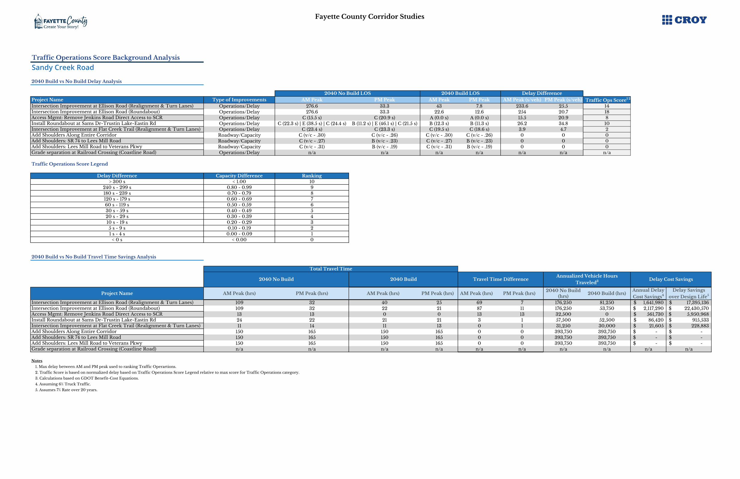
Fayette County Corridor Studies
Traffic Operations Score Background Analysis
Sandy Creek Road
2040 Build vs No Build Delay Analysis
Project Name Type of Improvements AM Peak PM Peak AM Peak2 PM Peak3 AM Peak (s/veh) PM Peak (s/veh) Traffic Ops Score1 2
Intersection Improvement at Ellison Road (Realignment & Turn Lanes) Operations/Delay 276.6 33.3 43 7.8 233.6 25.5 14Intersection Improvement at Ellison Road (Roundabout) Operations/Delay 276.6 33.3 22.6 12.6 254 20.7 18Access Mgmt: Remove Jenkins Road Direct Access to SCR Operations/Delay C (15.5 s) C (20.9 s) A (0.0 s) A (0.0 s) 15.5 20.9 8Install Roundabout at Sams Dr-Trustin Lake-Eastin Rd Operations/Delay C (22.3 s) | E (38.5 s) | C (24.4 s) B (11.2 s) | E (46.1 s) | C (21.5 s) B (12.3 s) B (11.3 s) 26.2 34.8 10Intersection Improvement at Flat Creek Trail (Realignment & Turn Lanes) Operations/Delay C (23.4 s) C (23.3 s) C (19.5 s) C (18.6 s) 3.9 4.7 2Add Shoulders Along Entire Corridor Roadway/Capacity C (v/c - .30) C (v/c - .26) C (v/c - .30) C (v/c - .26) 0 0 0Add Shoulders: SR 74 to Lees Mill Road Roadway/Capacity C (v/c - .27) B (v/c - .23) C (v/c - .27) B (v/c - .23) 0 0 0Add Shoulders: Lees Mill Road to Veterans Pkwy Roadway/Capacity C (v/c - .31) B (v/c - .19) C (v/c - .31) B (v/c - .19) 0 0 0Grade separation at Railroad Crossing (Coastline Road) Operations/Delay n/a n/a n/a n/a n/a n/a n/a
Traffic Operations Score Legend
Delay Difference Capacity Difference Ranking> 300 s < 1.00 10
240 s - 299 s 0.80 - 0.99 9180 s - 239 s 0.70 - 0.79 8120 s - 179 s 0.60 - 0.69 760 s - 119 s 0.50 - 0.59 630 s - 59 s 0.40 - 0.49 520 s - 29 s 0.30 - 0.39 410 s - 19 s 0.20 - 0.29 35 s - 9 s 0.10 - 0.19 21 s - 4 s 0.00 - 0.09 1
< 0 s < 0.00 0
2040 Build vs No Build Travel Time Savings Analysis
Project Name AM Peak (hrs) PM Peak (hrs) AM Peak (hrs)2 PM Peak (hrs)3 AM Peak (hrs)22 PM Peak (hrs)332040 No Build
(hrs)2040 Build (hrs)
Annual Delay Cost Savings4
Delay Savings over Design Life5
Intersection Improvement at Ellison Road (Realignment & Turn Lanes) 109 32 40 25 69 7 176,250 81,250 1,641,980$ 17,395,136$ Intersection Improvement at Ellison Road (Roundabout) 109 32 22 21 87 11 176,250 53,750 2,117,290$ 22,430,570$ Access Mgmt: Remove Jenkins Road Direct Access to SCR 13 13 0 0 13 13 32,500 0 561,730$ 5,950,968$ Install Roundabout at Sams Dr-Trustin Lake-Eastin Rd 24 22 21 21 3 1 57,500 52,500 86,420$ 915,533$ Intersection Improvement at Flat Creek Trail (Realignment & Turn Lanes) 11 14 11 13 0 1 31,250 30,000 21,605$ 228,883$ Add Shoulders Along Entire Corridor 150 165 150 165 0 0 393,750 393,750 -$ -$ Add Shoulders: SR 74 to Lees Mill Road 150 165 150 165 0 0 393,750 393,750 -$ -$ Add Shoulders: Lees Mill Road to Veterans Pkwy 150 165 150 165 0 0 393,750 393,750 -$ -$ Grade separation at Railroad Crossing (Coastline Road) n/a n/a n/a n/a n/a n/a n/a n/a n/a n/a
Notes
1. Max delay between AM and PM peak used to ranking Traffic Operartions.
2. Traffic Score is based on normalized delay based on Traffic Operations Score Legend relative to max score for Traffic Operations category.
3. Calculations based on GDOT Benefit-Cost Equations.
4. Assuming 6% Truck Traffic.
5. Assumes 7% Rate over 20 years.
Delay Cost SavingsAnnualized Vehicle Hours
Traveled3
Delay Difference
Total Travel Time
2040 No Build
2040 No Build LOS 2040 Build LOS
2040 Build Travel Time Difference

Fayette County Corridor Studies
Environmental Score Background Analysis
Sandy Creek Road
Project Name Resources
Present1 RankingEnvironmental Impact Score2
Intersection Improvement at Ellison Road (Realignment & Turn Lanes) 1 4 4.0Intersection Improvement at Ellison Road (Roundabout) 1 4 4.0Access Mgmt: Remove Jenkins Road Direct Access to SCR 1 1 1.0Install Roundabout at Sams Dr-Trustin Lake-Eastin Rd 3 3 3.0Intersection Improvement at Flat Creek Trail (Realignment & Turn Lanes) 1 3 3.0Add Shoulders Along Entire Corridor 15 1 1.0Add Shoulders: SR 74 to Lees Mill Road 11 1 1.0Add Shoulders: Lees Mill Road to Veterans Pkwy 4 4 4.0Grade separation at Railroad Crossing (Coastline Road) 1 1 1.0
Environmental Impact Legend
Resources Impact Number RankingNeglible 0 Impacts 5Minor 1 to 4 Impact 4
Moderate 5 to 9 Impact 3Major 10 to 15 Impacts 2
Significant16+ Impacts
Presence of USTs or Cemetery
1
Notes
1. Environmental Resources present based on number environmental resouces within 1/4 mile radius of project.
2. Environmental Impact Score is normalized based on Environmental Impact Legend relative to max score for Environmental category.

Fayette County Corridor Studies
Right-of-Way Score Background Analysis
Sandy Creek Road
Project Name Undeveloped
ParcelsDeveloped
(Residential)Developed
(Commercial)Right-of-Way
Impacts1 RankingR/W Impact
Score2
Intersection Improvement at Ellison Road (Realignment & Turn Lanes) 1 2 0 5 4 12.0Intersection Improvement at Ellison Road (Roundabout) 1 3 0 7 4 12.0Access Mgmt: Remove Jenkins Road Direct Access to SCR 1 2 0 5 4 12.0Install Roundabout at Sams Dr-Trustin Lake-Eastin Rd 2 3 0 8 3 9.0Intersection Improvement at Flat Creek Trail (Realignment & Turn Lanes) 1 1 0 3 4 12.0Add Shoulders Along Entire Corridor 34 88 2 220 0 0.0Add Shoulders: SR 74 to Lees Mill Road 18 58 0 134 1 3.0Add Shoulders: Lees Mill Road to Veterans Pkwy 16 30 2 86 2 6.0Grade separation at Railroad Crossing (Coastline Road) 2 9 0 20 2 6.0
Right-of-Way Legend
R/W Impact by Parcel Type(1) Undeveloped Parcel = 1 Impact
(1) Developed Residential Parcel = 2 Impacts(1) Developed Commercial Parcel = 5 Impacts
Right-of-Way Impact Number RankingNeglible 0 Impacts 5Minor 1 to 5 Impact 4
Moderate 6 to 19 Impact 3
Major20 to 99 Impacts or
Impacts Railroad Xing
2
Significant 100 to 149 Impacts 1Monumental > 150 Impacts 0
Notes
1. Right-of-Way Impacts based on number of parcels encroached upon.
2. Right-of-Way Impact Score is normalized based on Right-of-Way Impact Legend relative to max score for Right-of-Way Category.
Parcel Type

Fayette County Corridor Studies
Project Costs Score Background Analysis
Sandy Creek Road
Project Name Project Construction
Cost EstimateRelative Project
Cost Score1Crash Costs Savings
over Design LifeDelay Savings over
Design LifeTotal Benefits B/C Ratio
Relative B/C Score2
Overall Project Cost Score
Intersection Improvement at Ellison Road (Realignment & Turn Lanes) 250,000$ 10.0 369,040$ 17,395,136$ 17,764,176$ 71.1 5.0 15.0Intersection Improvement at Ellison Road (Roundabout) 1,400,000$ 8.0 502,658$ 22,430,570$ 22,933,228$ 16.4 4.0 12.0Access Mgmt: Remove Jenkins Road Direct Access to SCR 400,000$ 10.0 2,313,730$ 5,950,968$ 8,264,697$ 20.7 5.0 15.0Install Roundabout at Sams Dr-Trustin Lake-Eastin Rd 1,650,000$ 8.0 100,303,070$ 915,533$ 101,218,604$ 61.3 5.0 13.0Intersection Improvement at Flat Creek Trail (Realignment & Turn Lanes) 250,000$ 10.0 119,736$ 228,883$ 348,619$ 1.4 1.0 11.0Add Shoulders Along Entire Corridor 750,000$ 10.0 74,867,873$ -$ 74,867,873$ 99.8 5.0 15.0Add Shoulders: SR 74 to Lees Mill Road 300,000$ 10.0 53,321,447$ -$ 53,321,447$ 177.7 5.0 15.0Add Shoulders: Lees Mill Road to Veterans Pkwy 450,000$ 10.0 21,546,426$ -$ 21,546,426$ 47.9 5.0 15.0Grade separation at Railroad Crossing (Coastline Road) 22,650,000$ 2.0 106,962$ n/a -$ 0.0 0.0 2.0
Project Cost Score Legend
Project Cost Ranking$0 to $999,999 10
$1,000,000 to $1,999,999 8$2,000,001 to $4,999,999 6$5,000,000 to $9,999,999 4
$10,000,000 to $24,999,999 2> $25,000,000 0
B/C Score Legend
B/C Ratio Ranking> 20.00 5
10.00 to 19.99 45.00 to 9.99 33.00 to 4.99 21.01 to 2.99 1
< 1 0
Notes
1. Relative Project Cost Score based on Project Cost Score Legend relative to 66% max score for Project Cost category.
2. Relative B/C Score based on B/C Score Legend relative to 33% max score for Project Cost category.
Benefit-to-Cost Analysis

Fayette County Corridor Studies
Public Support Score Background Analysis
Sandy Creek Road
Project Name PIOH 2 Comment Form
- Phase II Score 1Online
Survey ValueOnline Survey - Phase II Score 2
Typical Comments/Major TakeawaysPublic Support
Score
Intersection Improvement at Ellison Road (Realignment & Turn Lanes) 6.27 3.63 5.45
• Ellison Road is huge issue during the school year, turn lanes does not address safety. Should be signalized during the year.
• Roundabout or all way stop would be better• Add lighting at intersection
• Lots of bike traffic to school on Ellison
11.7
Access Mgmt: Remove Jenkins Road Direct Access to SCR 4.32 2.31 3.47 • Several comments against closing off church access 7.8
Install Roundabout at Sams Dr-Trustin Lake-Eastin Rd 5.88 3.52 5.28• Concerned with slowing down traffic operations
• Dangerous intersection 11.2
Intersection Improvement at Flat Creek Trail (Realignment & Turn Lanes) 4.85 3.53 5.30• Agree with westbound left lane but not northbound turn lane, safety
concern; Make AWSC• Hill also needs to be cut lower
10.1
Hawk Signal Near Pinewood Studios 4.32 3.17 4.76• County should not pay for HAWK signal which will be inconveniences to
road users, Pinewood Studios should be a pedestrian bridge instead9.1
Add Shoulders Along Entire Corridor 5.45 3.57 5.36
• Add bike lane, there is a lot of bike traffic• Add lighting
• Project should include correcting curves, improving sight distance, and lowering hills
10.8
Add Shoulders: SR 74 to Lees Mill Road 5.45 3.57 5.36
• Add bike lane, there is a lot of bike traffic• Add lighting
• Project should include correcting curves, improving sight distance, and lowering hills
10.8
Add Shoulders: Lees Mill Road to Veterans Pkwy 5.45 3.57 5.36
• Add bike lane, there is a lot of bike traffic• Add lighting
• Project should include correcting curves, improving sight distance, and lowering hills
10.8
Other Comment/Project Ideas
Sandy Creek Road at Adams Road
Grade separation at Railroad crassing (Coastline Road)Signalized RCUT at Highway 74Turn Lane at Gaddy PropertyControl speed on Sandy Creek Road, Add radar signsDrainage along Sandy Creek RoadMiscellaneousNeeds for direct route from Fayetteville to I-85 using Highway 92Signal at Veterans Parkway at SR 92Ellison Road at Jenkins Road very Dangerous
When will culvert be complete on Graves Road between Easter and Ginger CakeConsider improvements for Jenkins Road schoolsWhen will Founder's Studio be constructed?
Notes
1. Comment Forms Score is normalized relative to max score for 50% Public Support category.
2. Online Survey Score is normalized (max 5 pts) relative to max score for 50% Public Support category.
• Repair potholes at Highway 74• Blind spot near railroad;
Blind curve westbound at Sandy Creek Road and Adams Road needs to be addressed
Notes
Notes