sandhill cranes and the platte river
TRANSCRIPT

University of Nebraska - LincolnDigitalCommons@University of Nebraska - Lincoln
USGS Northern Prairie Wildlife Research Center Wildlife Damage Management, Internet Center for
1982
Sandhill Cranes and the Platte RiverGary L. KrapuU. S. Fish and Wildlife Service, [email protected]
Kenneth J. ReineckeU. S. Fish and Wildlife Service
Charles R. FrithU. S. Fish and Wildlife Service
Follow this and additional works at: http://digitalcommons.unl.edu/usgsnpwrc
Part of the Other International and Area Studies Commons
This Article is brought to you for free and open access by the Wildlife Damage Management, Internet Center for at DigitalCommons@University ofNebraska - Lincoln. It has been accepted for inclusion in USGS Northern Prairie Wildlife Research Center by an authorized administrator ofDigitalCommons@University of Nebraska - Lincoln.
Krapu, Gary L.; Reinecke, Kenneth J.; and Frith, Charles R., "Sandhill Cranes and the Platte River" (1982). USGS Northern PrairieWildlife Research Center. 87.http://digitalcommons.unl.edu/usgsnpwrc/87

The Platte River Basin
Gary L. Krapu, Kenneth J. Reinecke', and Charles R. Frith2 U.S. Fish and Wildlife Service, Northern Prairie Wildlife Research Center, Jarnestown, North Dakota
Introduction
The waters of many western rivers have been diverted by man for irrigation and other consumptive uses (Ohmart et al. 1977, Johnson 1978). As flows in certain rivers diminished precipitously during this century, numerous conflicts have arisen brought on by changes affecting various interests. The Platte River is such an example. With approximately 69 percent of the annual flows destined for the Platte now removed upstream (Kroonemeyer 1979) and additional projects proposed that would utilize remaining flows, intense competition and widespread concern have developed among the factions relying on the river's flows to meet their needs.
One effect of the growing water shortage in the Platte River Basin has been alteration of riparian habitats in the Big Bend reach of the Platte River, an area of major importance to populations of several species of migratory birds (Figure 1). Foremost among the biological concerns has been the impact of habitat alteration on the midcontinent population of sandhill cranes (Grus canademis) (Frith 1974, Lewis 1977, Krapu 1979). The cranes gather along the Platte and North Platte Rivers from late February to mid-April each year, reaching a peak population of approximately a half-million birds during late March (U.S. Fish and Wildlife Service 1981). Upon departure, the birds stop briefly on the Canadian prairies and then disperse to breeding grounds in central and arctic Canada, Alaska, and Siberia.
The U.S. Fish and Wildlife Service (FWS), recognizing the need to protect riparian habitats suitable for the cranes, attempted in the early 1970s to establish a 14,993-acre (6070-ha) national wildlife refuge along the Platte River near Grand Island. This plan met with strong opposition from landowners who feared condem- nation of their properties (Wallenstrom 1976); local resistance culminated in polit- ical opposition to the plan within the State. In the debate that followed announce- ment of FWS plans, numerous questions were raised concerning the need for a refuge in the Big Bend reach of the Platte River to satisfy the requirements of cranes and other migratory birds. To acquire the necessary information to answer these questions, FWS began a 3-year investigation in 1978. The study was part of an Interior-directed project also involving research by the U.S. Geological Survey and U.S. Bureau of Reclamation. The purpose of this paper is threefold: (1) to describe changes in riparian habitats along the Platte during modem times and identify underlying causes of habitat alteration, (2) to describe effects of habitat alteration on the staging sandhill crane population, and (3) to consider alternatives for maintaining the habitat base needed to support the crane population during the stopover period.
'Resent address: USFWS, c/o WES, Env. Lab., Box 631, Vicksburg, MS 39180 'Present address: USFWS, 1811 W. 2nd. St., Grand Island, NE 68801
The Platte River Basin extends across about 90,000 square miles (233,100 km2) of Colorado, Wyoming, and Nebraska. The Platte begins near North Platte, Nebraska, at the confluence of the North and South Platte Rivers (Figure 1). The River loops southeastward to form the Big Bend reach before crossing eastern Nebraska and joining the Missouri River near Omaha. The headwaters of the North Platte River are in north central Colorado, about 90 miles (145 km) northwest of Denver, and those of the South Platte about 60 miles (97 km) southwest of Denver (Figure 1). Both rivers begin as snowmelt in the Rocky Mountains. Our studies were limited primarily to the 203-mile (327-km) reach of river in Nebraska lying between King- sley Dam and Chapman.
The hydrology of the Platte River and its major tributaries is complicated by the massive alteration of flows that has accompanied water resource development. After leaving the Rocky Mountains, both the North and South Platte Rivers flow across hundreds of miles of semi-arid plains before converging to form the Platte. To compensate for the dry climate, water development was initiated shortly after settlement of the Valley began in the late 1850s. Irrigation was first recorded on lands adjacent to the South Platte River in 1863 and, following some initial setbacks, began to expand rapidly (McKinley 1935). By 1894, canals served 364,200 acres (147,449 ha) and 1,442,000 additional acres (575,709 ha) were under survey in the Platte Valley. Irrigation development has continued to expand along the Platte and throughout much of the State during the twentieth century. By 1979, Nebraska had 7,445,200 irrigated acres (3,014,251 ha) and ranked third in the Nation in total lands under irrigation (Anonymous 1979).
Much of the impact of upstream water resource development in the Big Bend reach of the Platte River has come from massive irrigation projects along the major tributaries. Reservoirs built to impound flows for inigation include Pathfinder Reservoir completed in 1909; Guernsey Reservoir, 1927; Alcova Reservoir, 1938; Seminoe Reservoir, 1939; Lake McConaughy, 1941; Kortes Reservoir, 1950; Glendo Reservoir, 1957; and Gray Reef Reservoir, 1%1 (Missouri River Basin Commission 1975). Storage capacity of these facilities totals approximately 5.0 million acre- feet (6,200 million m3). Small offstream reservoirs raise the capacity to about 5.4 million acre-feet (6,700 million m3). Another 1.3 million acre-feet (1,600 d i o n m3) of flows are impounded along the South Platte River. In recent times, the growth of center pivot inigation, energy development, and an expanding human population, particularly in Colorado, have placed additional demands on the water resources of the Platte River Basin.
The Big Bend Reach-A Historical Perspective
The channel of the Platte River between North Platte and Grand Island was originally very wi&, and characterized by braided channels and a shifting streambed. In 1842, the explorer John C. Fremont recorded a channel width of 5,350 feet (1,630 m) just below the confluence of the North and South Platte Rivers (Williams 1978). Before development, annual flows at Overton, Nebraska, were variable but probably averaged about 2.9 million acre-feet (3,600 million m3) (G. Miller, pers. comm.); the highest annual flow recorded at the Overton gauging station in the
Sandhill Cranes and the Platte River
Published in TRANSACTIONS OF THE FORTY-SEVENTH NORTH AMERICAN WILDLIFE AND NATURAL RESOURCES CONFERENCE (Washington, 1982)

g g twentieth century was about 4.5 million acre-feet (5,500 million m3) in 1917 (Bentall 1975).
g 2 Water use and diversions upstream have reduced the channel of the Platte River % to a small fraction of its former width. Recently published hydrologic data have 5 4 indicated, for example, that channel width of the North Platte River downstream
4 8 from Kingsley Dam, and the mainstem of the Platte above Overton, declined by t? 8 80-90 percent from 1865 to 1969 (Williams 1978). Withdrawal of about 1,064,500 % 3 acre-feet (1,300 million m3) annually at the Tri-County Diversion Dam (Missouri 3 River Basin Commission 1975) has decreased channel width drastically in the 60.5- c 8 mile (97.6-km) reach upstream from Overton. An average of only 400,000 acre-
& g feet (493 million m3) of water per year pass Brady. Some of these flows are diverted a JZ for irrigation between Brady and Cozad. Below the main Tri-County Canal dis- 5 " 3 2 charge site, an average of 533,000 acre-feet (660 million m3) of returning power &I generation water increase annual flows in the reach between Overton and Grand 1 .: Island to about 800,000 acre-feet (990 million m3) (Missouri River Basin Commis- 5i 6 sion 1975).
3 4 Explorers that traveled along the Platte during the early to mid nineteenth 0 t? 5 % century noted the presence of trees on islands and in some areas along the banks
(Eschner et al. 1981). However, the area encompassed by woody vegetation has expanded many fold in modem times. Most of the former Platte River channel that '% Z a has been exposed by flow depletion is now covered by stands of woody growth of
B B varying age and height. Cottonwood (Populus deltoides) and willow (Salix spp.)
8 3 initially invade exposed channel sites and are followed by numerous other species. Riparian woodlands border almost the entire reach from Kingsley Dam down-
8 !i stream to Grand Island. Channel shrinkage caused by reduced flows is most n advanced in the reach between the Tri-County Diversion Dam (near North Platte)
82 and the canal discharge site near Overton. Between these points, the River consists
11 of several narrow braided channels flowing through maturing stands of woodland; d
a G our studies indicated unobstructed channel width in 1979 averaged only about 55
9 8 yards (50 m) between the Tri-County Dam and discharge site and 155 yards (142 u 3 32 m) downstream from the discharge site to Keamey. The magnitude of channel
b 8 shrinkage in this century is evident when the above listed measurements of channel
2 .g width are compared to measurements for this reach of river taken just after the
,0 3 Civil War. A Union Pacific Railroad survey in 1866 reported that the Platte channel
2 1 from Keamey to North Platte was about 1,310 to 2,190 yards (1,200 to 2,000 m) wide (Williams 1978). 4 2
8 3 Woody vegetation now maturing in the Big Bend reach became established primarily following construction of a series of dams and reservoirs from 1927 to
% Fi 8 c.4 1941. Closure of the gates of Kingsley Dam and the Tri-County Diversion Dam in
=jm 1941 probably were the most significant factors contributing to the development
ZJ, 8 of woody species on the floodplain, especially between Elm Creek and Chapman
.s a 5 (Currier 1981). Encroachment by woody vegetation is continuing in the Overton to Grand Island reach. It is probable that during earlier periods before the higher
s 9 g flows were lost to upstream diversions, these flows scoured away any seedlings that had become established in the channel. The number of seeds dispersing into the channel during summer has grown immensely during modem times as stands of trees became established throughout the reach. Increased seed dispersal in combination with variable flow patterns existing during the growing season have
Forty-Seventh North American Wildlife Conference Sandhill Cranes and the Platte River 545
often produced conditions conducive to germination and seedling growth. Extended perids of low or no flow occurred during 12 years between 1950 and 1975 in the reach from Overton to Grand Island (Bentall 1975).
Changes in the hydrology of the River have also impacted the native meadows bordering the channel because these lands are underlain by extensive sand and gravel deposits containing waters that are linked hydrologically to the river system (Hurr 1981). Heavy flows in the Platte during spring in the past maintained a high water table and extensive wet meadows on the floodplain. The marked reduction in flows because of upstream diversions has lowered the water table in the valley and thereby contributed to the loss of a major part of the meadow habitat. Before 1942, when flows were substantially reduced in the Platte following completion of the Kingsley and the Tri-County Diversion Dams, the meadows were managed primarily as pasture or hayland because water saturated surface soils during most of the growing season and prevented annual tillage. In recent years, however, the combination of agricultural drainage, depleted flows in the River, and extensive pumping of groundwater for irrigation have lowered the water table substantially during the summer months. This set of conditions has made it economically feasible to grow cash crops on most lands in the Valley. A survey undertaken as part of our studies in 1979 indicated about three-fourths of the native meadows had been converted to other uses between Overton and Grand Island. This estimate of meadow losses is conservative as numerous sites have been lost since the inven- tory.
The Current Ditribution of Sandhill Cranes
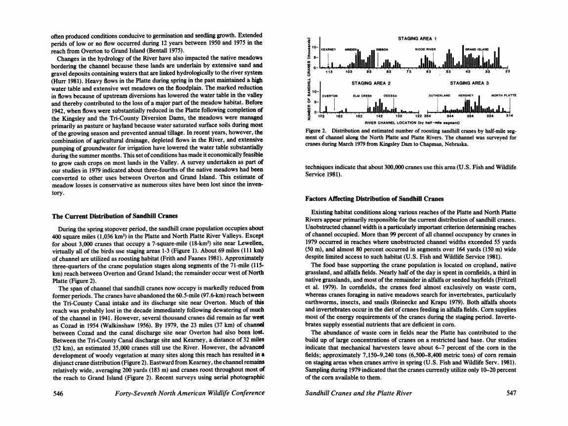
During the spring stopover period, the sandhill crane population occupies about 400 square miles (1,036 km3 in the Platte and North Platte River Valleys. Except for about 3,000 cranes that occupy a 7-square-mile (18-km2) site near Lewellen, virtually all of the birds use staging areas 1-3 (Figure 1). About 69 miles (111 km) of channel are utilized as roosting habitat (Frith and Faanes 1981). Approximately three-quarters of the crane population stages along segments of the 71-mile (115- km) reach between Overton and Grand Island; the remainder occur west of Nortb Platte (Figure 2).
The span of channel that sandhill cranes now occupy is markedly reduced from former periods. The cranes have abandoned the 60.5-mile (97.6-km) reach between the Tri-County Canal intake and its discharge site near Overton. Much of this reach was probably lost in the decade immediately following dewatering of much of the channel in 1941. However, several thousand cranes did remain as far west as Cozad in 1954 (Walkinshaw 1956). By 1979, the 23 miles (37 km) of c h d between Cozad and the canal discharge site near Overton had also been lost. Between the Tri-County Canal discharge site and Kearney, a distance of 32 miles (52 km), an estimated 35,000 cranes still use the River. However, the advanced development of woody vegetation at many sites along this reach has resulted in a disjunct crane distribution (Figure 2). Eastward from Kearney , the channel remains relatively wide, averaging 200 yards (183 m) and cranes roost throughout most of the reach to Grand Island (Figure 2). Recent surveys using aerial photographic
546 Forty-Seventh North American Wildlife Conference
A STAGING AREA 1 I
STAGING AREA 2
5 10-
STAGING AREA 3
ELM CREEK ODESSA SUTHERLAND HERSHEY . NORTH PLATTE
RIVER CHANNEL LOCATION (by hOIf-m(lo mogment)
Figure 2. Distribution and estimated number of roosting sandhill cranes by half-mile seg- ment of channel along the North Platte and Platte Rivers. The channel was surveyed for cranes during March 1979 from Kingsley Dam to Chapman, Nebraska.
techniques indicate that about 300,000 cranes use this area (U.S. Fish and Wildlife Service 1981).
Factors Affecting Distribution of Sandhill Cranes
Existing habitat conditions along various reaches of the Platte and North Platte Rivers appear primarily responsible for the current distribution of sandhill cranes. Unobstructed channel width is a particularly important criterion determining reaches of channel occupied. More than 99 percent of all channel occupancy by cranes in 1979 occurred in reaches where unobstructed channel widths exceeded 55 yards (50 m), and almost 80 percent occurred in segments over 164 yards (150 m) wide despite limited access to such habitat (U.S. Fish and Wildlife Service 1981).
The food base supporting the crane population is located on cropland, native grassland, and alfalfa fields. Nearly half of the day is spent in cornfields, a third in native grasslands, and most of the remainder in alfalfa or seeded hayfields (Fritzell et al. 1979). In cornfields, the cranes feed almost exclusively on waste corn, whereas cranes foraging in native meadows search for invertebrates, particularly earthworms, insects, and snails (Reinecke and Krapu 1979). Both alfalfa shoots and invertebrates occur in the diet of cranes feeding in alfalfa fields. Corn supplies most of the energy requirements of the cranes during the staging period. Inverte- brates supply essential nutrients that are deficient in corn.
The abundance of waste corn in fields near the Platte has contributed to the build up of large concentrations of cranes on a restricted land base. Our studies indicate that mechanical harvesters leave about 6-7 percent of the corn in the fields; approximately 7,150-9,240 tons (6,5004,400 metric tons) of corn remain on staging areas when cranes arrive in spring (U.S. Fish and Wildlife Sew. 1981). Sampling during 1979 indicated that the cranes currently utilize only 10-20 percent of the corn available to them.
Sandhill Cranes and the Platte River 547

Current Status of Water Development
During the last 30 years, expansion of irrigation development within the Platte Valley has been from high-yielding groundwater resources through gravity and center pivot inigation systems. The growth of irrigation from groundwater resources in the counties used by staging cranes has been phenomenal. In Buffalo and Hall counties, for example, which include major parts of staging areas 1 and 2, the number of registered wells rose from 54 in 1919 (Bentall 1975 to 6,162 in 1980 (Johnson and Pederson 1981). An additional 400,000 + acre-feet (490 + million m3) of Platte flows are expected to be consumed annually by groundwater pumping before the year 2020 (Missouri River Basin Commission 1975).
Although most recent water developments in the Platte River Basin have tapped underground aquifers, several projects are under consideration that would rely on existing surface flows. Among the water projects proposed is Narrows Dam along the South Platte River in Colorado. This project would withdraw approximately 100,000 acre-feet (123 million m3) annually for irrigation and other uses, but has been stalled in recent years because of environmental and economic concerns. If this authorized project were built, it would remove about 12.5 percent of the remaining 800,000 acre-feet (984 million m3) of flows destined for the Platte River at Overton.
A proposed plan to transfer waters from the Platte River Basin to the Little Blue Basin in south central Nebraska, if implemented, would divert about 125,000 acre- feet (154 million m3) or 23 percent of the return flows entering the River at the Tri- County Canal discharge site near Overton. A major obstacle to this project was removed in December 1980 when the Nebraska Supreme Court ruled in favor of allowing inter-basin transfer of waters within the State when deemed in the public interest. The project is under litigation, however, from downstream interests.
Although the Mid-State Project planned for the Big Bend area of south central Nebraska in the early 1970s was tabled following its defeat in a local referendum in 1973, a project named Prairie Bend is now under consideration, which, if authorized and built, would remove up to 210,000 acre-feet (258 million m3) of flows annually in the upper Big Bend reach.
Existing flows in the Platte are inadequate to meet proposed needs even with total utilization of the remaining surface flows in the River. The cumulative impact of the aforementioned water projects, if built, plus other uses of the remaining flows of the Platte are shown in Figure 3. If the three projects were built, the annual water budget of the Platte would be reduced to about 449,000 acre-feet (552 million m3). This is about 16 percent of the amount of water the River carried in 1850. Further proposed developments including projected groundwater develop- ment theoretically would produce a negative annual water budget.
In addition to the above-mentioned projects that have been under consideration for some time, a project has been proposed in recent months that would store 315,000 acre-feet (388 million m 3 of water in a reservoir to be built on Plum Creek near Lexington. The water stored in this reservoir would come from the Tri- County Canal system and be released back into the Platte to maintain current flows in the Big Bend reach. These flows would be diverted from the River near Chapmao just below staging area 1 for use in groundwater recharge and direct irrigation in the Upper Big Blue Natural Resources District. This project is jointly sponsored
548 Forty-Seventh North American Wildlife Conference
1E / N A R R O W S DAM
LITTLE BLUE TRANSFER 1 J. , ( n ,PRAIRIE BEND
GROUNDWATER DEVELOPMENT PROJECTS
F i r e 3. Estimated annual water budget of the Platte River at Overton, Nebraska, in 1850 and at present (cross-hatched bars), and, with the completion of certain proposed projects, projected groundwater development, and other uses (clear bars). Effects of potential future development on the annual water budget are presented in a cumulative setting.
by the Platte River Whooping Crane Trust and local irrigators and reflects an attempt to satisfy both the needs of cranes and agriculture.
Potential Risks to Crane Population From Habitat Deterioration
As with any species whose numbers are concentrated by habitat loss into an area of diminishing size, the midcontinent population of sandhill cranes while at the Platte will become increasingly vulnerable should the present trend of habitat loss continue. Severe local storms, for example, can cause heavy mortality on restricted areas. The susceptibility of cranes when caught in hail storms is docu- mented in the literature (Merrilll%l, Higgins and Johnson 1978, Heflebower and Klett 1980). Although hail storms are infrequent during the spring staging period, several have been recorded in Nebraska during March and April of the past 22 years (U.S. Environmental Data Service 1959-1980). Similarly, oil spills, pesticide contamination, or other forms of accidental pollution grow in importance as the concentration of cranes builds. Powerlines, housing developments, roads, and other changes in the landscape on staging areas also take on added significance when viewed in this context. Previous studies have shown significant crane mor-
Sandhill Cranes and the Platte River 549

tality resulting from collisions with powerlines situated between roosting sites and feeding grounds (Tacha et al. 1979).
Crowding also increases the risk of disease problems. Although sandhill cranes have not suffered known major disease outbreaks along the Platte to date, this situation could change in the future. Avian cholera outbreaks in the Rainwater Basin area, a few miles to the south of crane staging areas 1 and 2, have caused substantial losses of migrant waterfowl. In the spring of 1980, for example, about 31,000 dead ducks and geese were recovered during an outbreak (Friend 1981) that is estimated to have killed 80,000 birds. Prospects of sandhill cranes moving into disease-infected areas of the Rainwater Basin area in significant numbers increase as habitat deteriorates along the Platte. Patterns of whooping crane (Grus ameri- cana) use of the Platte River lend support to this concern. Until recent decades, whooping cranes were observed more frequently near the Platte River than at any other site along their migration route on the Great Plains (Johnson 1981). Yet in a recent 30-year period (1951-1980), there have been only five confirmed sightings of whooping cranes on or near the Platte River. During the same period, use of the Rainwater Basin area by whooping cranes increased steadily.
Although waste corn is now plentiful in fields along the Platte, reliance on this food source by the cranes increases their vulnerability to abrupt changes in land use. Most of the cropland on crane staging areas is in private ownership and potentially subject to alternate uses should economic or other factors warrant the change. Loss or diminished abundance of corn in the future could create food shortages in light of the high densities of cranes present as a result of the limited suitable roosting habitat now available.
Any circumstances that may reduce recruitment or increase mortality are of particular concern because of the low reproductive rate of sandhill cranes. These birds do not breed until at least their thud year (Boise 1979) and usually raise one offspring each summer (Buller 1979), resulting in an annual recruitment rate of only 10 to 12 percent (Johnson 1979).
Conclusions The midcontinent population of sandhill cranes during their annual stopover
period in the Platte River Valley rely principally on three habitat types, i.e. a relatively broad channel for roosting, and cropland and meadows for feeding. The rapid rate of loss of riparian habitats used by cranes has promoted the need for development and implementation of a habitat preservation and management plan to stablize conditions and thereby lessen the risks to the population from increased crowding.
The most critical need of cranes is continued access to suitable roosting habitat in the reach between Overton and Grand Island and upstream from North Platte. Channel roosting habitat can be maintained most effectively through acombination of water management and other cost-effective methods of woody vegetation con- trol.
Meadows supply invertebrates, important to meeting certain nutritional require- ments of cranes, and serve as rest sites during the daytime. Past conversion of much of the meadow acreage to other uses and its continuing rapid rate of loss suggests that prompt measures be taken to protect part of the remaining meadows
Forty-Seventh North American Wildlife Conference
along the River. Protection of meadows can be accomplished through either pur- chase in fee title or by conservation easement. A plan that involves purchase of certain strategically located tracts to permit application of intensive management practices to increase food supply and protects other important meadows through conservation easements appears well suited for meeting current and future needs of the crane population. Conservation easements would allow current land uses to continue when compatible with the maintenance of crane habitat, but would prevent future development.
The dependence of the crane population on corn for its energy requirements during the annual stopover underscores the need for maintaining an abundance of high energy foods in close proximity to meadows and roosting habitat. Some cropland should be protected against future changes in agricultural land use that could eliminate most of the waste corn presently available in spring. The large 1
numbers of waterfowl that gather along the Platte River during late winter and early spring would also benefit from steps taken to maintain an ample supply of corn.
Acknowledgements We thank Paul J. Cunier, Charles W. Dane, Douglas H. Johnson. James C. Lewis, and
Garnett P. Williams for their critical review of this manuscript and Reid Goforth, David Trauger, and Rey Stendell, administrators at the Northern Prairie Wildlife Research Center during the course of these investigations, for their continuing support and encouragement. We are indebted to FWS personnel at the Ecological Services Oflice at Grand Island, Nebraska, for their major assistance to the project, and in particular, Gene Miller for numerous helpful suggestions throughout the study and Kent Kroonemeyer, former Super- visor of the Grand Island Oflice, for his support of our efforts. We are grateful to Darold Walls and Al Trout, Managers of the Rainwater Basin Wetland Management District, for their active support of our studies. We also appreciate the assistance provided by personnel in the U.S. Geological Survey, U.S. Bureau of Reclamation, and Nebraska Game and Parks Commission during the course of these studies. Douglas Facey, Mia Hay, and Brooks Gehring are thanked for their assistance in data analysis, Charles Shaiffer and Mavis Meyer for preparing the figures, and Debra Reirners and Tammy Fercho for typing several drafts of the manuscript.
Literature Cited Anonymous. 1979. Inigated acreage swey-1979. Irrig. J. 29:58A-58H. Bentall, R. 1975. Hydrology: Nebraska Mid-State Division and associated areas. Univ. of
Nebraska, Institute of Agriculture and Natural Resources, Lincoln. 256 pp. Boise, C. M. 1979. Lesser sandhill crane banding program on the Yukon-Kuskokwim Delta,
Alaska. Pages 229-236 in Proc. 1978 Crane Workshop. Colorado State Univ., Fort Collins.
Buller, R. J. 1979. Lesser and Canadian sandhill crane populations, age structure, and harvest. Spec. Sci. Rep. Wild. 221. U.S. Fish and Wild. Service., Washington, D.C. 10 PP.
Cunier, P. 1. 1981. The floodplain vegetation of the Platte River: phytosociology, forest development, and seedling establishment. Ph.D. Thesis. Iowa State Univ., Ames. 332 PP.
Eschner, T. R., R. F. Hadley, and K. D. Crowley. 1981. Hydrologic and morphologic changes in channels of the Platte River Basin: a historical perspective. U.S. Geological S w e y Open-File Report 81-1125. 57 pp.
Friend, M. 1981. Waterfowl diseases--changing perspectives for the future. Int. Waterfowl Symp. 4:189-1%.
Frith, C. R. 1974. The ecology of the Platte River as related to sandhill cranes and other
Sandhill Cranes and the Platte River 55 1

waterfowl in south central Nebraska. M.S. Thesis. Kearney State College, Kearney, Neb. 115 pp.
, and C. A. Faanes. 1981. Inventory of sandhill crane roosting habitat on the F'latte and North Platte Rivers, Nebraska. Pages 13-16 in Roc. 1981 Crane Workshop. National Audubon Society, Washington, D.C.
Fritzell, E. K., G. L. Krapu, and D. G. Jorde. 1979. Habitat-use patterns of sandhill cranes in the Platte River Valley-a preliminary report. Pages 7-11 in Proc. 1978 Crane Workshop. Colorado State Univ., Fort Collins.
Heflebower, C. C., and E. V. Klett. 1980. A killer hailstorm at the Washita Refuge. Bull. Okla. Ornithol. Soc. 13:26-28.
Higgins, K. F., and M. A. Johnson. 1978. Avian mortality caused by a September wind and hail storm. Prairie Natur. 10:434.
Hurr, R. T. 1981. Ground-water hydrology of the Mormon lsland Crane Meadows Wild& Area, near Grand Island, Hall County, Nebraska. U.S. Geological Survey Open-Fik Report 81-1109. 16 pp.
Johnson, D. H. 1979. Modeling sandhill crane population dynamics. Spec. Sci. Rep. Wildl. 222. U.S. Fish and Wildl. Sew., Washington, D.C. 10 pp.
Johnson, K. 1981. Whooping crane use of the Platte River, Nebraska-History, status, and management recommendations. Pages 33-43 in Roc. 1981 Crane Workshop. National Audubon Society, Washington, D.C.
Johnson, M. S., and D. T. Pederson. 1981. Groundwater levels in Nebraska, 1980. Nebr. Conserv. and Surv. Div. Water Surv. Pap. 51.65 pp.
Johnson, R. R. 1978. The Lower Colorado River: a western system. Pages 41-55 in Strategies for protection and management of floodplain wetlands and other riparian ecosystems. Gen. Tech. Rep. WO-12.U.S. For. Serv., Washington D.C.
Krapu, G. L. 1979. Sandhill crane use of staging areas in Nebraska. Pages 1-5 in Proc. 1978 Crane Workshop. Colorado State Univ., Fort Collins.
Kroonemeyer, K. E. 1979. The United States Fish and Wildlife Sewice's Platte Rivh National'Wildlife Study. Pages 29-32 in Proc. 1978 Crane Workshop. Colorado State Univ., Fort Collins.
Lewis, J. C., Chairman. 1977. Sandhill crane (Grus canadensis). Pages 5-43 in G. C. Sanderson, ed. Management of migratory shore and upland game birds in North Amer- ica. Intl. Assoc. Fish Wildl. Agencies, Washington, D.C. 358 pp.
McKinley, J. L. 1935. The influence of the Platte River upon the history of the Valley. Ph.D. Thesis. Univ. of Nebraska, Lincoln. 316 pp.
Merrill, G. W. l%l. Loss of 1,000 lesser sandhill cranes. Auk 78:641-642. Missouri River Basin Commission. 1975. Platte River Basin, Nebraska-Level B Study:
Hydrology and hydraulics. 167 pp. Ohmart, R. D., W. 0. Deason, and C. Burke. 1977. A riparian case history: the Colorado
River. Pages 35-47 in Importance, preservation and management of riparian habitat: a symposium. Gen. Tech. Rep. RM-43. U.S. For. Serv., Fort Collins, Colo.
Reinecke, K. J., and G. L. Krapu. 1979. Spring food habits of sandhill cranes in Nebraska. Pages 13-19 in Roc. 1978 Crane Workshop. Colorado State Univ., Fort Collins.
Tacha, T. C., D. C. Martin, and C. G. Endicott. 1979. Mortality of sandhill cranes associated with utility highlines in Texas. Pages 175-176 in Proc. 1978 Crane Workshop. Colorado State Univ., Fort Collins.
U.S. Environmental Data Service. 1959-1980. Storm data. Vol. 1-22. U.S. Fish and Widlife Service. 1981. The Platte River Ecology Study. Spec. Res. Rep. U.S.
Fish and Wildl. Sew. Jarnestown, N.D. 187 pp. Walkinshaw, L. H. 1956. Two visits to the Platte Rivers and their sandhill crane migration.
Nebr. Bird Rev. 24:1&21. Wallenstrom, R. L. 1976. The Platte River National WildliieRefuge. Pages 141-143 in Proc.
Int. Crane Workshop. Oklahoma State Univ., Stillwater. Williams, G. P. 1978. The case of the shrinking channels-the North Platte and Platte Rivers
in Nebraska. Circ. 781. U.S. Geol. Surv., Reston, Va. 48 pp.
Forty-Seventh North American Wildlife Conference