san joaquin county surveyor's · pdf filesan joaquin county surveyor's office ......
TRANSCRIPT

SAN JOAQUIN COUNTY SURVEYOR'S OFFICE
GUIDE TO THE PREPARATION OF MAPS
FINAL MAPS, PARCEL MAPS & RECORDS OF SURVEY
WARREN D. SMITH COUNTY SURVEYOR FEBRUARY 2016

TABLE OF CONTENTS
SUBJECT PAGE NO.
SUBMITTAL REQUIREMENTS ................................................................................................................. 1-2
FEE SCHEDULE ......................................................................................................................................... 2A
CHECKLIST FOR ALL MAPS .................................................................................................................... 3-7 MAP STATEMENTS FOR RECORDS OF SURVEY .................................................................................. 8
CITY OF STOCKTON General Checklist for Final Maps ................................................................................................. 9-1 0 Map Statements for Final Maps ................................................................................................. 11-17 General Checklist for Parcel Maps with 5 or more parcels ........................................................ 18-19 Map Statements for Parcel Maps with 5 or more parcels ................................ : ......................... 20-26
CITY OF MANTECA General Checklist for Final Maps ............................................................................................... 27 -28 Map Statements for Final Maps ................................................................................................. 29-36 General Checklist for Parcel Maps ............................................................................................. 37-38 Map Statements for Parcel Maps ............................................................................................... 39-45
CITYOFLODI General Checklist for Final Maps .............................................................................................. .46-47 Map Statements for Final Maps ............................................................................................... ..48-54
CITY OF ESCALON General Checklist for Final Maps ............................................................................................... 55-58 Map Statements for Final Maps ................................................................................................. 57 -63 General Checklist for Parcel Maps ............................................................................................. 64-65 Map Statements for Parcel Maps ............................................................................................... 66-72
CITY OF RIPON General Checklist for Final Maps ................................................................................................ 73-74 Map Statements for Final Maps .................................................................................................. 75-81 General Checklist for Parcel Maps ............................................................................................. 82-83 Map Statements for Parcel Maps ................................................................................................. 84-90
CITY OF LATHROP General Statement for Final Maps .............................................................................................. 91-92 Map Statements for Final Maps .................................................................................................. 93-99 General Checklist for Parcel Maps ............................................................................................ 100-101 Map Statements for Parcel Maps ............................................................................................ 102-109
CITY OF TRACY General Statement for Final Maps .......................................................................................... 11 0-111 Map Statements for Final Maps .............................................................................................. 112-118 General Checklist for Parcel Maps .......................................................................................... 119-120 Map Statements for Parcel Maps ............................................................................................ 121-127
COUNTY OF SAN JOAQUIN General Checklist for Final Maps ............................................................................................ 128-129 Map Statements for Final Maps .............................................................................................. 130-135 General Checklist for Parcel Maps ......................................................................................... 136-139 Map Statements for Parcel Maps ........................................................................................... 140-146 Tax Letter Information ................................................................................................................... 147 Lot Line Adjustment Procedures ............................................................................................ 148-149 Abandonment Certification ........................................................................................................... 150
MAP STATEMENT FOR SOUTH SAN JOAQUIN IRRIGATION DISTRICT ................................................ 151
CERTIFICATE OF CORRECTION FORMATS County Final Map ........................................................................................................................... 152 County Parcel Map ......................................................................................................................... 153 Record of Survey ............................................................................................................................ 154
-A-E:ISURVEYOR.WK\GUIDE·BK\CONTENTS.doc (06107)

MAP SUBMITTAL REQUIREMENTS
When making new map submittals to the County Surveyor, please provide the following:
1. FINAL MAP OR PARCEL MAP
A. 2 Check Prints of signed and notarized original map, including all owners, trustees or beneficiaries, as required.
B. 1 set of calculations for boundary, blocks, lots and 1/2 the road rights-of-way including centerline data. All calc's must follow map courses only and be closed-looped.
C. Subdivision/Parcel Map Guarantee, as applicable.
D. Preliminary Title report less than 6 months old.
E. Copies of all deeds referenced on the map and in the Title Report, and Grant Deed to subject property.
F. Applicable Checking Fee. ($1 ,300 + $1 00/lot) (Revised Sheets $500/each)
G. Processing Agreements and Maps to the Board of Supervisors ($1 ,500)
2. RECORD OF SURVEY
A. 2 Check Prints of original map.
B. 1 set of calculations for the boundary, individual parcels and all closed configurations indicating measured data. All calc's must follow map courses only and be closedlooped.
C. Original and 2 unsigned, preliminary copies of new legal descriptions or, if in a final form, signed/sealed/dated. (for LLA's only.)
D. Grant Deeds to subject property and adjoining parcels.
E. Applicable Checking Fee. ($325/sheet without LLA- $650 plus $325 per additional map sheet(s) with LLA)
3. COUNTY LOT LINE ADJUSTMENT WITHOUT RECORD OF SURVEY
A. Existing Grant Deed(s) to subject property.
B. Original and 2 unsigned, preliminary copies of new legal descriptions or, if in final form, signed/sealed/dated.
C. Applicable Checking Fee. ($325)
4. LEGAL DESCRIPTIONS (All except County LLA appl.'s & LAFCo)
A. Existing Grant Deed{s) to subject property.
B. 2 Copies of new legal descriptions(s) and map{s).
C. Applicable Checking Fee. ($850)

5. CORNER RECORD
A. Original and 2 copies of signed/sealed/dated corner record.
6. CERTIFICATE OF CORRECTION (No Checking Fee)
A.
B.
7. NOTES
A.
B.
C.
D.
E.
Applicable Recording Fee. ($14.00 first page plus $3.00/page thereafter) Make check payable to: "San Joaquin County Recorder".
Written Clearance from City authorizing County to process.
Incomplete submittals will be placed "on-hold" and not be logged into the system until deemed complete.
Make checks payable to: "San Joaquin County Department of Public Works".
Do not submit checks payable to the County Recorder except for Certificates of Correction.
LLA denotes Lot Line Adjustment.
All projects sitting dormant for 2+ years will be recharged current applicable fees for re-evaluation of project.
SURVEYOR.WK\GUI DE-BKIMAP-SU8.2.doc (08/13)
2

Surveyor Division Fee Schedule Effective August 25. 2010
Subdivisions
Final Maps (County and Cities) Base Fee Per Lot (Numbered and Lettered) Revised Certificate Sheet
Parcel Maps (County and Cities) Base Fee Per Parcel (Numbered and Lettered) Revised Certificate Sheet
No Fee For "Designated Remainder" Parcels
Annexations
Legal Descriptions (LAFCo)
District Annexations/Detachments/Formations
Other Services
Processing Agreements and Maps to The Board of Supervisors
Records of Survey with LA* Records of Survey w/o LA*
Legal Descriptions (County LA Appl.'s) Legal Descriptions (All except County LA Appl.'s and LAFCo)
Corner Records Certificates of Correction
(Collect Check payable to San Joaquin County Recorder For Recording)
* LA denotes "Lot Line Adjustment"
Fee For Service
$1,300 $100 $500
$1,300 $100 $500
$700 min. or 20 percent of LAFCo's acreage fee, whichever is greater Actual Costs
$1,500
$650 plus $325 per additional sheet(s) $325/sheet
$325
$850
None None
Note: All projects sitting dormant for 2+ years will be recharged current applicable fees for re-evaluation of project.
2A SURVEYOR.WK\GUIDE-81<\FEES.doc (08/1 0)

CHECKLIST FOR ALL MAPS
Is map on 18" x 26" sheets?
Does each sheet have a CLEAR 1" margin around sheet?
Is map legibly drawn and printed?
Is map in black on tracing cloth or polyester film?
Is each sheet numbered with respect to the total number of sheets?
Is ALL lettering and numbering a suggested minimum of 0.1 0" high?
Is map title appropriately worded containing geographic location?
Does map have appropriate statements/certificates? (i.e., Owner's, Trustee's, Beneficiary's, Engineer's, Surveyor's, Irrigation District's, Planning Director's, County Surveyor's, City Engineer's, Planning Commission's, City Clerk's, City Council's, Clerk of the Board of Supervisors', County Recorder's)
Are all statements/certificates/signatures dated, and sealed as appropriate?
Are all registration expiration dates noted?
Are Deed References shown on map?
Is the REQUIRED vicinity map, its scale, and the site location clearly shown, still maintaining suggested minimum lettering of 0.1 0" high?
If more than 2 sheets are used in preparing the map, is the REQUIRED index (key) map shown?
Is each sheet's relationship to adjoining sheets shown?
Is the map oriented with north to top or left side?
Is north arrow and scale shown?
Is scale large enough to show details clearly and maintain suggested minimum lettering height of 0.10"?
Is boundary of subject property shown with a HEAVY SOLID line?
Are proper survey procedures used? (i.e., prorations, section breakdowns, deed interpretations, proper control scheme). Are section and 1/4 section corners physically set and not just calculated? (3/4" x 30" iron pin-minimum monument size)
Are ALL surrounding surveys and the related monumentation properly evidencing the establishment of boundary clearly shown?
Are sections, townships, ranges and grants properly labeled?
Are discrepancies of less than 1/10,000 in precision with existing record data shown?
3

Is record data shown by individual reference and NOT collectively?
Are all City limits and County lines shown?
Do all Easements show Deed Reference, size and location relative to property lines?
Are PRIVATE Easements properly labeled?
Are Restricted Access areas labeled and shown?
Is all curve data per local ordinance shown? (i.e., lot/curve No., radius, central angle, arc length, chord bearing, chord distance and radial bearings of non-radial lines)
Is the curve data for the TOTAL curve shown?
Does the sum of the parts EQUAL the total distance or central angle?
Are all street names shown along with their widths?
Is the "Basis of Bearings" shown and does it identify the actual bearing and the filing data of the referenced map? (Must be between two found monuments.)
If California Coordinate System 83, Zone 3 (Epoch date) is used as a basis of bearings, is bearing, grid factor and filing data shown?
Is control scheme shown along with Description of Monuments found for CCS83, Zone 3? Are California Grid Coordinates shown, if required?
Is the proper tense used on all acknowledgments? (Singular or plural as applicable)
Is the proper drafting direction used? (From bottom to top of sheet and from lower right hand corner)
Are original mylars acceptable to the County Recorder?
Are solid lines used for street/road rights-of-way?
Does Legend include symbols for monuments found, set or replaced and a listing of ALL abbreviations used on map? (See "SAMPLE ABBREVIATIONS, SYMBOLS AND NOTES" at the end of this Checklist.)
Do Calc's show radial bearings?
Are existing street names spelled correctly?
Do references to Records of Survey use what Recorder's Statement SAYS GENERALLY "Volume" for 1 thru 12 and "Book" 13 to present?
Are monuments found or replaced, described as to kind, size, location, tag no. and other data relating thereto? Give reference to a record map or field book where the monument was set or accepted. If none, state no record or origin unknown.
Is the San Joaquin County Surveyor's Base Map Sheet No. shown in the lower left corner, but not in margin- SAMPLE: (D.D. Sheet No._).
4
NOTE:
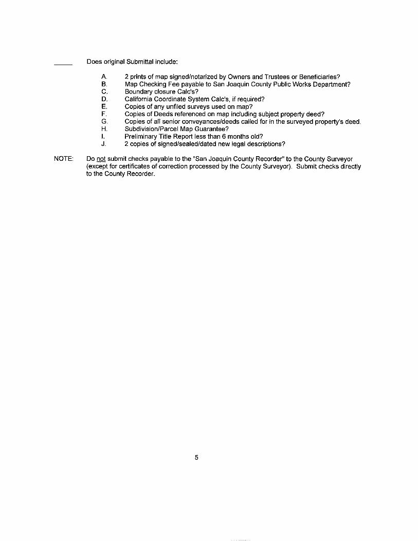
Does original Submittal include:
A. 2 prints of map signed/notarized by Owners and Trustees or Beneficiaries? B. Map Checking Fee payable to San Joaquin County Public Works Department? C. Boundary closure Calc's? D. California Coordinate System Calc's, if required? E. Copies of any unfiled surveys used on map? F. Copies of Deeds referenced on map including subject property deed? G. Copies of all senior conveyances/deeds called for in the surveyed property's deed. H. Subdivision/Parcel Map Guarantee? I. Preliminary Title Report less than 6 months old? J. 2 copies of signed/sealed/dated new legal descriptions?
Do not submit checks payable to the "San Joaquin County Recorder" to the County Surveyor (except for certificates of correction processed by the County Surveyor). Submit checks directly to the County Recorder.
5

SAMPLE ABBREVIATIONS. SYMBOLS AND NOTES
ABBREVIATIONS:
S.J.C.R. DENOTES San Joaquin County Records
S.J.C.S.R. DENOTES San Joaquin County Surveyor's Records
M. &P. DENOTES Maps and Plats
R.S. DENOTES Record of Survey
P.M. DENOTES Parcel Map
O.R. DENOTES Official Records
"A" DENOTES Book "A" of Deeds
I.N. DENOTES Instrument Number
CNEL DENOTES Community Noise Equivalent Level
SENEL DENOTES Single Event Noise Exposure Level
SFN DENOTES Searched, found nothing
CALC DENOTES Calculated Data per (Add Reference)
(M) DENOTES Measured Data
(CM) DENOTES Calculated from measured data
CCS83 DENOTES California Coordinate System 83 (Epoch date)
BOB DENOTES Basis of Bearings
(R) DENOTES Radial Bearing
PUE DENOTES Public Utility Easement
//Ill DENOTES Restricted Public Access
W.C. DENOTES Witness Corner
-X- DENOTES Existing Fence Line
-P- DENOTES Existing PG&E Electric Line
(R1) DENOTES R.S. 28-10 (Example)
(R2) DENOTES P.M. 16-20 (Example)
(R3) DENOTES M. & P. 25-5 (Example)
D.N. DENOTES Document Number
1.0.0. DENOTES Irrevocable Offer of Dedication
6

SYMBOLS: Monument Set (Description of) ... .. .. .. ....... .. . .. . .. o Monuments Set in Cast Iron Box (Description of) ...... .
Monuments Found (Description of) .................. J
Monuments Found in Cast Iron Box (Description of) ... (!)
NOTES: 1. 2. 3.
4.
5.
All references are to San Joaquin County Records and Book or Volume precedes Page. All distances are measured unless otherwise noted. All lot dimensions shown along lot lines that contain a witness corner are from lot corner to lot corner. A (Width) wide (Type) easement to be conveyed by separate instrument subsequent to the filing for record of this map. Monuments are not tagged nor of record unless otherwise noted.
SURVEYOR.WKIGUIDE-BK\CH-LIST.ALL (02121106) 7

RECORD OF SURVEY STATEMENTS
SURVEYOR'S STATEMENT:
This map correctly represents a survey made by me or under my direction in conformance with
the requirements of the Professional Land Surveyors' Act at the request of (Person's Name)
in (Month, Year)
Dated this _____ day of ________ , 201_.
Surveyor (License No.)
COUNTY SURVEYOR'S STATEMENT:
This map has been examined in accordance with Section 8766 of the Professional Land
Surveyors' Act this ___ day of ______ , 201_.
WARREN D. SMITH, L.S. 4842 County Surveyor
RECORDER'S STATEMENT:
Filed this ____ day of __________ , 201_, at __
Book ___ of Surveys, at page ____ , at the request of
FEE:$ ____ _
BY:
.M. in
STEVE J. BESTOLARIDES Assessor-Recorder-County Clerk
"A-=-s""si7St.-:a:::n71t/"'D"'e-=-p""utc-:y-.R""e=-=c:-::o-=rd:r:e:-::-r
SURVEYOR.WK\GUIDE-BK\RCD-SV.STM (02/16) 8

GENERAL CHECKLIST FOR CITY OF STOCKTON FINAL MAPS
SEE CHECKLIST FOR ALL MAPS
1. Does Subdivision Guarantee match EXACTLY with Owner'sffrustee's/Beneficiary's names?
2. Are all Owner'srrrustee's/Beneficiary's signatures dated and notarized properly?
3. Does the date of Owner'sffrustee's/Beneficiary's signatures match the corresponding certificate?
4. Has the Notary PRINTED his name under his signature and shown the expiration date of his Notary License?
5. Does the Notary's Seal, if used, match certificate as to State/County and expiration date?
6. Are ALL necessary Offers of Dedication to the Public for Public Use made? (i.e., Streets, Roads, right-of-way widenings, Public Utility Easements, etc.).
7. Are all necessary Offers of Dedication to the local agency made? (i.e., Access rights, lot _iliQl storm drain retention pond site, well site, pump station site, etc.); Certificate of Dedication required?
8. Does the appropriate statement/certificate accepting or rejecting Offers of Dedication match EXACTLY the Offers of Dedication made by Owners?
9. Does the index (key) map show the overall subdivision and the portions thereof included on each sheet?
10. Does the index (key) map show all street names, lot numbers and sheet numbers?
11. Are ALL Easements and Restricted Access Rights reflected in the Preliminary Title Report shown?
12. Are all street widenings properly labeled? (i.e., 10' street right-of-way dedication).
13. Is subdivision agreement note on C.O.S. final maps?
14. Are the lots on the Final Map numbered consecutively beginning with 1?
15. Are all bearings and distances shown for boundary, blocks, lots and centertines?
16. Are all the REQUIRED lot areas shown to the nearest square foot if less than 1 acre or to the nearest 1/100 of an acre, if more than 1 acre?
17. Does original Submittal include:
A. 2 prints of map signed bY Owners, and Trustees or Beneficiaries? B. Map Checking Fee? C. Subdivision Guarantee? D. Preliminary Title Report? E. Boundary closure Calc's? F. Block & Lot closure Calc's? G. 2-Street right-of-way closure Calc's incl. centerline? H. California Coordinate System Calc's on grid? I. Copies of any unfiled surveys used on map? J. Copies of Deeds referenced on map and in Title Report?
9

CITY OF STOCKTON FINAL MAP SAMPLE NOTES FOR REFERENCE
1. Where there are easement holders of record:
Pursuant to Section 66436 of the California Subdivision Map Act, the signatures of the following parties have been omitted:
Name of Party, Type of Interest, Deed Reference
2. Basis of Bearings:
Bearings, distances and coordinates are based on the California Coordinate System 83, Zone 3 (Epoch date). A line between City of Stockton Monuments No. __ and No. __ bears (bearing) as calculated from City of Stockton Traverse Control Monument Survey, Phase __ , filed for record in Book of Surveys, at Page __ , San Joaquin County Records. All distances shown are ground level distances and must be multiplied by (factor) to obtain grid distances.
3. Existing restricted access within new access openings to be abandoned by City of Stockton Council Resolution.
4. Each lot shall be designed, graded, and maintained to provide proper drainage without ponding, causing soil erosion or draining onto adjacent property. All lots are to drain from rear to front unless otherwise shown.
5. Owner/Developer must comply with noise attenuation requirements as specified in the noise element to the General Plan.
6. This Final Map is subject to the provisions of an Avigation Hazard Easement recorded on ___ _ as Document No. , San Joaquin County Records.
7. This Final Map is subject to the provisions of a Subdivision Agreement recorded on ----------'' as Document No. , San Joaquin County Records.
8. Lot __ is for a private street covered entirely by a public utility easement and shall be maintained by a mandatory Homeowners' Association.
9. Lot __ is for landscaping purposes and shall be maintained by a mandatory Homeowners' Association.
10. Lot __ is for private streets, landscaping, and a public utility easement for sanitary sewer, domestic water and storm drain systems. All of the landscaping and private streets will be owned and maintained by a mandatory Homeowners' Association.
SURVEYOR.WK\GUIDE-BK\CH-LIST.COS (09/24/03) 10

FINAL MAP WITHIN STOCKTON
OWNERS' STATEMENT:
We, the undersigned, hereby state that we are all the parties having record title interest in the
lands subdivided and shown on this Final Map of "Tract No. __ , Subdivisions of
San Joaquin County, _ ___,(-'-'N"'a""m....,e""o"'f'-'S"'u..,b,d""iv'-'is,i,_on'"'"l,___", City of Stockton, California, and we
hereby consent to the preparation and filing of this Final Map in the office of the County
Recorder of San Joaquin County, California.
We also offer the real property described below, dedicated [in fee] [as an easement] for
public purposes, [all Public Utility Easements] [in fee] [in easement] [all street rights-of-way]
[the (widthl-foot widening of right-of-way along (Street Name) ] [in fee] [to the City of
Stockton lot (No.) ] [relinquish to the City of Stockton all access rights of (Lot Numbers) to
and from (Street Name) *(except at the approved access openings)*] all as shown on
this Final Map.
Dated this_ day of ___ , 201_.
(Print Name/Title) (Print Name/Title)
*USE ONLY IF APPLICABLE*
SURVEYOR.WK\GUIDE-BK\FM-COS.OWN (08113) 11

FINAL MAP WITHIN STOCKTON
*CERTIFICATE OF DEDICATION: (Do not combine with Owners' Statement)
The following real property is dedicated by (name and address of subdivider dedicating
the property), for the purpose of (name public improvement or construction of public facility):
(LEGAL DESCRIPTION)
The City of Stockton shall reconvey the property to the subdivider if the City of
Stockton makes a determination pursuant to Government Code Section 66477.5 that the
same public purpose for which the property was dedicated does not exist, or the property or
any portion thereof is not needed for public utilities.
*APPLIES ONLY TO DEDICATIONS IN FEE (SEE SECTION 66477.5) USE ONLY IF APPLICABLE
SURVEYORWK\GUIDE-BK\FM-COS.DED (09!24/03)
12

NOTARY-ALL (02/16)
A notary public or other officer completing this certificate verifies only the identity of the individual who signed the document to which this certificate is attached, and not the truthfulness, accuracy, or validity of that document.
STATE OF CALIFORNIA )
) ss. COUNTY OF SAN JOAQUIN )
On _____________________________, before me, STEVE J. BESTOLARIDES, Assessor-Recorder-County Clerk of San Joaquin County, personally appeared __________________________________________________________, who proved to me on the basis of satisfactory evidence to be the person(s) whose name(s) is/are subscribed to the within instrument, and acknowledged to me that he/she/they executed the same in his/her/their authorized capacity(ies), and that by his/her/their signature(s) on the instrument the person(s), or the entity upon behalf of which the person(s) acted, executed the instrument.
I certify under PENALTY OF PERJURY under the laws of the State of California that the foregoing paragraph is true and correct.
WITNESS my hand and official seal:
___________________________________ Deputy County Clerk
A notary public or other officer completing this certificate verifies only the identity of the individual who signed the document to which this certificate is attached, and not the truthfulness, accuracy, or validity of that document.
STATE OF CALIFORNIA )
) ss. COUNTY OF ______________ )
On ______________________, before me, ____________________________, a Notary Public, personally appeared _______________________________________ _____________________________________________________________________, who proved to me on the basis of satisfactory evidence to be the person(s) whose name(s) is/are subscribed to the within instrument, and acknowledged to me that he/she/they executed the same in his/her/their authorized capacity(ies), and that by his/her/their signature(s) on the instrument the person(s), or the entity upon behalf of which the person(s) acted, executed the instrument.
I certify under PENALTY OF PERJURY under the laws of the State of California that the foregoing paragraph is true and correct.
WITNESS my hand and official seal:
(Seal) _____________________________________
_______________________________________________________,
Notary Public in and for said County and State
Commission No.: ___ Commission Expiration Date: ___

FINAL MAP WITHIN STOCKTON
[ENGINEER'S] [SURVEYOR'S] STATEMENT:
This map was prepared by me or under my direction and is based upon a field survey in
conformance with the requirements of the Subdivision Map Act and local ordinance at
the request of (name of person authorizing map) on (date). I hereby state that all the
monuments are of the character and occupy the positions indicated or that they will be
set in those positions before (date), and that the monuments are, or will be, sufficient to
enable the survey to be retraced, and that this final map substantially conforms to the
conditionally approved tentative map.
Dated this ____ day of __________ , 201_.
[Engineer][Surveyor] (License No.)
SURVEYOR.WK\GUIDE-BKIFM-COS.ENG (02/16/06)
14

FINAL MAP WITHIN STOCKTON
CITY ENGINEER'S STATEMENT:
I, _________ ,, hereby state that I am the City Engineer of the City of
Stockton, California, and that I have examined this Final Map of "Tract No. __ _
Subdivisions of San Joaquin County, (Name of Subdivision)", City of Stockton,
California and that the subdivision shown hereon is substantially the same as it
appeared on the tentative map, and any approved alterations thereof. I further state
that this Final Map complies with all the provisions of Chapter 16, Article 6 of the
Stockton Municipal Code, and any amendments thereto, applicable at the time of
approval of the tentative map.
Dated this ________ day of _________ , 201 __
=-:---=----:------::--:---' R.C. E. ___ _ City Engineer- Development
E:\SURVEYOR.WK\GUIDE-BK\FM-COS.CE (08/13) 15

FINAL MAP WITHIN STOCKTON
CITY CLERK'S STATEMENT:
This is to state that at its regularly held meeting on the_ day of--'----' 201_, the City
Council of the City of Stockton, California per Council Resolution No. __ approved this Final
Map of "Tract No. , Subdivisions of San Joaquin County, (Name of Subdivision}", City
of Stockton, California, and accepted on behalf of the public for public use the offer of
dedication of [all Public Utility Easements] [accepted on behalf of the City the relinquishment
to the City of Stockton all access rights of (Lot Numbers) to and from (Street Name)
*(except at the approved access openings)*] all as shown on this Final Map and accepted the
offer of dedication of [all street rights-of-way] [the (width)-foot widening of right-of-way along
(Street Name) ] [lot (No.) ] subject to satisfactory completion of improvements thereon of
said street rights-of-way [and lot (No.)] in accordance with Chapter 16, Article 6 of the
Stockton Municipal Code, and any amendments thereto, applicable at the time of approval of
the tentative map.
Dated this ______ day of __________ , 201 __
BONNIE L. PAIGE, City Clerk
*USE ONLY IF APPLICABLE*
E:\SURVEYOR.WK\GUIDE-BK\FM-COS.CLK (08/13) 16

FINAL MAP WITHIN STOCKTON
COUNTY SURVEYOR'S STATEMENT:
I, Warren D. Smith, hereby state that I have examined this Final Map of "Tract No. __ ,
Subdivisions of San Joaquin County, (Name of Subdivision) ", City of Stockton,
California and that the subdivision shown hereon complies with all the provisions of
Chapter 2 of the California Subdivision Map Act, as amended, and that this Final Map is
technically correct.
Dated this ______ day of _________ , 201 __ _
WARREN D. SMITH, L.S. 4842 County Surveyor
RECORDER'S STATEMENT:
.M. Filed this ----:-::-:-day of:-::-:-:---,....-~------:--:-:' 201 __ , at __ _ in Book of Maps and Plats, at page , at the request of _____ _
Fee: $ ______ ___
STEVE J. BESTOLARIDES Assessor-Recorder-County Clerk
SURVEYOR.WK\GU IDE-BK\FM-COS.SV (02/16)
BY: -~~-~-~~-~---
Assistant/Deputy Recorder
17

GENERAL CHECKLIST FOR CITY OF STOCKTON PARCEL MAPS
WITH FIVE OR MORE PARCELS
SEE CHECKLIST FOR ALL MAPS
1. Does Parcel Map Guarantee match EXACTLY with Owner's/Trustee's/Beneficiary's names?
2. Are all Owner's/Trustee's/Beneficiary's signatures dated and notarized properly?
3. Does the date of Owner's/Trustee's/Beneficiary's signatures match the corresponding certificate?
4. Has the Notary PRINTED his name under his signature and shown the expiration date of his Notary License?
5. Does the Notary's Seal, if used, match certificate as to State/County and expiration date?
6. Are ALL necessary Offers of Dedication to the Public for Public Use made? (i.e., Streets, Roads, right-of-way widenings, Public Utility Easements, etc.).
7. Are all necessary Offers of Dedication to the local agency made? (i.e., Access rights, lot _lliQJ_, storm drain retention pond site, well site, pump station site, etc.); Certificate of Dedication required?
8. Does the appropriate statement/certificate accepting or rejecting Offers of Dedication match EXACTLY the Offers of Dedication made by Owners?
9. Are ALL Easements and Restricted Access Rights reflected in the Preliminary Title Report shown?
_ 10. Are all street widenings properly labeled? (i.e., 1 0' street right-of-way dedication).
11. Are the parcels on the Parcel Map numbered or lettered?
12. Is the unsurveyed remainder parcel noted as "DESIGNATED REMAINDER" with grant deed reference noted?
_ 13. Are the net, street right-of-way and gross areas shown?
_ 14. Does original Submittal include:
A. 2 prints of map signed by Owners, and Trustees or Beneficiaries? B. Map Checking Fee? C. Parcel Map Guarantee? D. Preliminary Title Report? E. Parcel Boundary closure Calc's? F. California Coordinate System Calc's on grid? G. Copies of any unfiled surveys used on map? H. Copies of Deeds referenced on map and in Title Report?
18

CITY OF STOCKTON PARCEL MAPS WITH FIVE OR MORE PARCELS SAMPLE NOTES FOR REFERENCE
1. Where there are easement holders of record:
Pursuant to Section 66436 of the California Subdivision Map Act, the signatures of the following parties have been omitted:
Name of Party, Type of Interest, Deed Reference
2. Basis of Bearings:
Bearings, distances and coordinates are based on the California Coordinate System 83, Zone 3 (Epoch date). A line between City of Stockton Monuments No. __ and No. ___ bears (bearing) as shown on City of Stockton Traverse Control Monument Survey, Phase __ , filed for record in Book __ of Surveys, at Page _, San Joaquin County Records. All distances shown are ground level distances and must be multiplied by (factor) to obtain grid distances.
3. Existing restricted access within new access openings to be abandoned by City of Stockton Council Resolution.
4. Owner/Developer must comply with noise attenuation requirements as specified in the noise element to the General Plan.
5. This Parcel Map is subject to the provisions of an Avigation Hazard Easement recorded on ____ , as Document No. , San Joaquin County Records.
6. This Parcel Map is subject to the provisions of a Subdivision Agreement recorded on ---------' as Document No. , San Joaquin County Records.
SURVEYOR.WK\GUIDE-BKIPM-LIST.COS (09/23/01)
19

PARCEL MAP WITHIN STOCKTON WITH FIVE OR MORE PARCELS
OWNERS' STATEMENT:
We, the undersigned, hereby state that we are all the parties having record title
interest in the lands subdivided and shown on this Parcel Map and we hereby consent
to the preparation and filing of this Parcel Map in the office of the County Recorder of
San Joaquin County, California.
We also offer the real property described below, dedicated [in fee] [as an easement] for
public purposes, [all Public Utility Easements] [relinquish to the City of Stockton all
access rights of (Parcel Numbers) to and from (Street Name) *(except at the
approved access openings)*] all as shown on this Parcel Map.
Dated this ______ day of _________ , 201_.
(Print Name/Title) (Print Name/Title)
*USE ONLY IF APPLICABLE*
SURVEYOR.WK\GUIDE-BK\PM-COS.OWN (08/13)
20

PARCEL MAP WITHIN STOCKTON WITH FIVE OR MORE PARCELS
*CERTIFICATE OF DEDICATION: (Do not combine with Owners' Statement)
The following real property is dedicated by (name and address of subdivider
dedicating the propertvl, for the purpose of (name public improvement or construction of
public facility):
(LEGAL DESCRIPTION)
The City of Stockton shall reconvey the property to the subdivider if the City of
Stockton makes a determination pursuant to Government Code Section 66477.5 that the
same public purpose for which the property was dedicated does not exist, or the property or
any portion thereof is not needed for public utilities.
*APPLIES ONLY TO DEDICATIONS IN FEE (SEE SECTION 66477.5) USE ONLY IF APPLICABLE
SURVEYORWK\GUIDE-BK\PM-COS.COD (09/24/03)
21

A notary public or other officer completing this certificate verifies only the identity of the individual who signed the document to which this certificate is attached, and not the truthfulness, accuracy, or validity of that document.
STATE OF CALIFORNIA
COUNTY OF SAN JOAQUIN
) ) ss. )
On , before me, STEVE J. BESTOLARIDES, Assessor-Recorder-County Clerk of San Joaquin County, personally appeared
, who proved to _m_e_o_n--..th-e---.-b-as~i-s-o'f-s-a"tis'f~a-ct'o_ry_e-v"id'e-n-ce-.-to-.--b-e't'he_p_e-rs-o-n'( s')c-w---.-ho_s_e_n_a_m-e( s) is/are subscribed to the within instrument, and acknowledged to me that he/she/they executed the same in his/her/their authorized capacity(ies), and that by his/her/their signature(s) on the instrument the person(s), or the entity upon behalf of which the person(s) acted, executed the instrument.
I certify under PENALTY OF PERJURY under the laws of the State of California that the foregoing paragraph is true and correct.
WITNESS my hand and official seal:
Deputy County Clerk
A notary public or other officer completing this certificate verifies only the identity of the individual who signed the document to which this certificate is attached, and not the truthfulness, accuracy, or validity of that document.
STATE OF CALIFORNIA ss.
COUNTY OF _____ _
On __________ , before me, ____________ _
a Notary Public, personally appeared _________________ _
who proved to me on the basis of satisfactory evidence to be the person(s) whose name(s) is/are subscribed to the within instrument, and acknowledged to me that he/she/they executed the same in his/her/their authorized capacity(ies), and that by his/her/their signature(s) on the instrument the person(s), or the entity upon behalf of which the person(s) acted, executed the instrument.
I certify under PENALTY OF PERJURY under the laws of the State of California that the foregoing paragraph is true and correct.
(Seal)
NOTARY-ALL (02/16)
WITNESS my hand and official seal:
Notary Public in and for said County and State
Commission No.: Commission Expi'-ra't"io-n---.-0-a•te_: ______ _

PARCEL MAP WITHIN STOCKTON WITH FIVE OR MORE PARCELS
[ENGINEER'S] [SURVEYOR'S] STATEMENT:
This map was prepared by me or under my direction and is based upon afield survey in
conformance with the requirements of the Subdivision Map Act and local ordinance at
the request of (Person's Name) on (Date) . I hereby state that this parcel map
substantially conforms to the approved or conditionally approved tentative map, if any.
All monuments are of the character and occupy the positions indicated and are
sufficient to enable the survey to be retraced.
Dated this ______ day of __________ , 201 __ .
[Engineer][Surveyor] (License No.)
SURVEYORWK\GUIDE-BK\PM-COS.5 (09/24/03)
23

PARCEL MAP WITHIN STOCKTON WITH FIVE OR MORE PARCELS
CITY ENGINEER'S STATEMENT:
I, , hereby state that I am the City Engineer of the City of
Stockton, California and that I have examined this Parcel Map and that the subdivision
shown hereon is substantially the same as it appeared on the tentative map, if required,
and any approved alterations thereof. I further state that this Parcel Map complies with
all the provisions of Chapter 16, Article 6 of the Stockton Municipal Code, and any
amendments thereto, applicable at the time of approval of the tentative map, if required.
Dated this _______ day of _________ , 201_.
-------------· R.C.E. __ _ City Engineer - Development
24 E:\SURVEYOR.WK\GUIDE-BK\PM-COS.ENG (02/16)

PARCEL MAP WITHIN STOCKTON WITH FIVE OR MORE PARCELS
CITY CLERK'S STATEMENT:
This is to state that at its regularly held meeting on the_ day of _____ , 201_,
the City Council of the City of Stockton, California per Council Resolution No. ___ _
approved this Parcel Map, and accepted on behalf of the public for public use the offer
of dedication of [all Public Utility Easements] [accepted on behalf of the City the
relinquishment to the City of Stockton all access rights of (Parcel Numbers) to and from
(Street Name) *(except at the approved access openings)*] all as shown on this
Parcel Map in accordance with Chapter 16, Article 6 of the Stockton Municipal Code,
and any amendments thereto, applicable at the time of approval of the tentative map.
Dated this ______ day of _________ , 201_.
BONNIE L. PAIGE, City Clerk
*USE ONLY IF APPLICABLE*
E:\SURVEYOR.WKIGUIDE·BKIPM·COS.CLK (08/13) 25

PARCEL MAP WITHIN STOCKTON WITH FIVE OR MORE PARCELS
COUNTY SURVEYOR'S STATEMENT:
I, Warren D. Smith, hereby state that I have examined this Parcel Map and it complies
with all the provisions of Chapter 2 of the California Subdivision Map Act, as amended,
and that this Parcel Map is technically correct.
Dated this _____ day of ___________ , 201 .
WARREN D. SMITH, L.S. 4842 Acting County Surveyor
RECORDER'S STATEMENT:
Filed this ___ day of __________ , 201_, at _____ .M. in
Book of Parcel Maps, at page , at the request of ____ _
Fee:$ ______ _
STEVE J. BESTO[ARIDES Assessor-Recorder-County Clerk
SURVEYOR.WK\GUIDE-BK\PM-COS.SV (02/16)
BY: "A7ss~i~stca--nnt/nD--e=pu~t~yrR~e~c~o~ra~e~r--
26

GENERAL CHECKLIST FOR CITY OF MANTECA FINAL MAPS
SEE CHECKLIST FOR ALL MAPS
1. Does Subdivision Guarantee match EXACTLY with Owner'srfrustee's/Beneficiary's names?
2. Are all Owner'srfrustee's/Beneficiary's signatures dated and notarized properly?
3. Does the date of Owner'srfrustee's/Beneficiary's signatures match the corresponding certificate?
4. Has the Notary PRINTED his name under his signature and shown the expiration date of his Notary License?
5. Does the Notary's Seal, if used, match certificate as to State/County and expiration date?
6. Are ALL necessary Offers of Dedication to the Public for Public Use made? (i.e., Streets, Roads, right-of-way widenings, Public Utility Easements, etc.).
7. Are all necessary Offers of Dedication to the local agency made? (i.e., Access rights, lot _iliQJ_, storm drain retention pond site, well site, pump station site, etc.); Certificate of Dedication required?
8. Does the appropriate statement/certificate accepting or rejecting Offers of Dedication match EXACTLY the Offers of Dedication made by Owners?
9. Does the index (key) map show the overall subdivision and the portions thereof included on each sheet?
10. Does the index (key) map show all street names, lot numbers and sheet numbers?
11. Are ALL Easements and Restricted Access Rights reflected in the Preliminary Title Report shown?
12. Are all street widenings properly labeled? (i.e., 10' street right-of-way dedication).
13. Are the lots on the Final Map numbered consecutively beginning with 1?
14. Are all bearings and distances shown for boundary, blocks, lots and centerlines?
15. Does original Submittal include:
A. 2 prints of map signed by Owners, and Trustees or Beneficiaries? B. Map Checking Fee? C. Subdivision Guarantee? D. Preliminary Title Report? E. Boundary closure Calc's? F. Block & Lot closure Calc's? G. 2-Street right-of-way closure Calc's incl. centerline? H. Copies of any unfiled surveys used on map? I. Copies of Deeds referenced on map and in Title Report?
27

CITY OF MANTECA FINAL MAP SAMPLE NOTES FOR REFERENCE
1. Where there are easement holders of record:
Pursuant to Section 66436 of the California Subdivision Map Act, the signatures of the following parties have been omitted:
Name of Party, Type of Interest, Deed Reference
SURVEYOR.WK\GUIOE-BK\CH-LIST.MAN (09124103)
28

FINAL MAP WITHIN MANTECA
OWNERS' STATEMENT:
We, the undersigned, hereby state that we are all the parties having record title interest in the
lands subdivided and shown on this Final Map of "Tract No. ___ , Subdivisions of
San Joaquin County, _ _..J(c!:N!.!;a!!Jm'-!.!e~of!..-'S~u~b~d!!.iv~i;!lsi~o!..!.n)L-_", City of Manteca, California, and we
hereby consent to the preparation and filing of this Final Map in the office of the County
Recorder of San Joaquin County, California.
We also offer the real property described below, dedicated [in fee] [as an easement] for
public purposes, [all Public Utility Easements] [in fee] [in easement] [all street rights-of-way]
[the (width)-foot widening of right-of-way along (Street Name) ] [in fee] [to the City of
Manteca lot (No.) ] [reserve to the City of Manteca, the right to control access over and
across the One-Foot Access Reserve Strip(s)] [relinquish to the City of Manteca all access
rights of (Lot Numbers) to and frorn (Street Name) *(except at the approved access
openings)*] all as shown on this Final Map.
Dated this ______ day of ________ , 201 __ .
(Print Name/Title) (Print Name/Title)
*USE ONLY IF APPLICABLE*
SURVEYOR.WK\GUIDE-BKIFM-MAN.OWN (08/13)
29

FINAL MAP WITHIN MANTECA
*CERTIFICATE OF DEDICATION: (Do not combine with Owners' Statement)
The following real property is dedicated by (name and address of subdivider
dedicating the property), for the purpose of (name public improvement or construction of
public facility):
(LEGAL DESCRIPTION)
The City of Manteca shall reconvey the property to the subdivider if the City of
Manteca makes a determination pursuant to Government Code Section 66477.5 that the
same public purpose for which the property was dedicated does not exist, or the property or
any portion thereof is not needed for public utilities.
*APPLIES ONLY TO DEDICATIONS IN FEE (SEE SECTION 66477.5) USE ONLY IF APPLICABLE
SURVEYOR.WKIGUIDE-BKIFM-MAN.DED (09/24/031
30

A notary public or other officer completing this certificate verifies only the identity of the individual who signed the document to which this certificate is attached, and not the truthfulness, accuracy, or validity of that document.
STATE OF CALIFORNIA
COUNTY OF SAN JOAQUIN ss.
On , before me, STEVE J. BESTOLARIDES, Assessor-Recorder-County Clerk of San Joaquin County, personally appeared ----~--~~~--~--~--~.---~~~------~~~------'who proved to me on the basis of satisfactory evidence to be the person(s) whose name(s) is/are subscribed to the within instrument, and acknowledged to me that he/she/they executed the same in his/her/their authorized capacity(ies), and that by his/her/their signature(s) on the instrument the person(s), or the entity upon behalf of which the person(s) acted, executed the instrument.
I certify under PENALTY OF PERJURY under the laws of the State of California that the foregoing paragraph is true and correct.
WITNESS my hand and official seal:
Deputy County Clerk
A notary public or other officer completing this certificate verifies only the identity of the individual who signed the document to which this certificate is attached, and not the truthfulness, accuracy, or validity of that document.
STATE OF CALIFORNIA ss.
COUNTY OF ______ _
On ___________________ , before me, ________________________ _
a Notary Public, personally appeared--------------------------------
who proved to me on the basis of satisfactory evidence to be the person(s) whose name(s) is/are subscribed to the within instrument, and acknowledged to me that he/she/they executed the same in his/her/their authorized capacity(ies), and that by his/her/their signature(s) on the instrument the person(s), or the entity upon behalf of which the person(s) acted, executed the instrument.
I certify under PENALTY OF PERJURY under the laws of the State of California that the foregoing paragraph is true and correct.
WITNESS my hand and official seal:
(Seal)
Notary Public in and for said County and State
Commission No. : __ c----;=;--.--------Commission Expiration Date: ______ _
NOTARY-ALL (02/16)

FINAL MAP WITHIN MANTECA
[ENGINEER'S] [SURVEYOR'S] STATEMENT:
This map was prepared by me or under my direction and is based upon a field survey in
conformance with the requirements of the Subdivision Map Act and local ordinance at
the request of (name of person authorizing map) on (date). I hereby state that all the
monuments are of the character and occupy the positions indicated or that they will be
set in those positions before (date), and that the monuments are, or will be, sufficient to
enable the survey to be retraced, and that this final map substantially conforms to the
conditionally approved tentative map.
Dated this ______ day of __________ , 201_.
[Engineer][Surveyor] (License No.)
SURVEYOR.WK\GUIDE-BK\FM-MAN.ENG (02/16/06) 32

FINAL MAP WITHIN MANTECA
COMMUNITY DEVELOPMENT DEPARTMENT STATEMENT:
This Final Map of "Tract No. ____ , Subdivisions of San Joaquin County,
____________ ", City of Manteca, California conforms to the
approved General Plan and the Manteca Municipal Code.
Dated this _____ day of ___________ , 201 __ .
FREDERIC CLARK Community Development Director
33 SURVEYOR.WK\GUIDE-BK\FM-MAN.PLN (02/16)

FINAL MAP WITHIN MANTECA
CITY ENGINEER'S STATEMENT:
I, Kevin L. Jorgensen II, hereby state that I am the City Engineer of the City of Manteca,
California and that I have examined this Final Map of "Tract No. ___ , Subdivisions
of San Joaquin County, (Name of Subdivision)", City of Manteca, California and that
the subdivision shown hereon is substantially the same as it appeared on the tentative
map, and any approved alterations thereof. I further state that this Final Map complies
with all the provisions of Title 16 of the Manteca Municipal Code, and any amendments
thereto, applicable at the time of approval of the tentative map.
Dated this _______ day of ___________ , 201_.
KEVIN L. JORGENSEN II, R.C.E. 77243 City Engineer
SURVEYOR.WK\GUIDE-BK\FM-MAN.CE (02/16) 34

FINAL MAP WITHIN MANTECA CITY COUNCIL'S STATEMENT:
This is to state that at its regularly held meeting on the day of , 201 ,
the City Council of the City of Manteca, California, approved this Final Map of
"Tract No. , Subdivisions of San Joaquin County, (Name of Subdivision)", City of
Manteca, California, and accepted on behalf of the public for public use the offer of dedication
of [all Public Utility Easements] and accepted on behalf of the City [the right to control access
over and across the One-Foot Access Reserve Strip(s)][the relinquishment to the City of
Manteca all access rights of (Lot Numbers) to and from (Street Name) *(except at the
approved access openings)*] all as shown on this Final Map and accepted the offer of
dedication of [the street rights-of-way] [the (width)-foot widening of right-of-way along
(Street Name) ] [lot (No.) ] subject to satisfactory completion of improvements thereon of
said street rights-of-way in accordance with Title 16 of the Manteca Municipal Code, and any
amendments thereto, applicable at the time of approval of the tentative map.
Dated this day of , 201 .
____________________ ATTEST: ________________________ STEPHEN F. DEBRUM, Mayor JOANN TILTON, City Clerk *USE ONLY IF APPLICABLE* SURVEYOR.WK\GUIDE-BK\FM-MAN.CLK (02/16) 35

FINAL MAP WITHIN MANTECA
COUNTY SURVEYOR'S STATEMENT:
I, Warren D. Smith, hereby state that I have examined this Final Map of
"Tract No. ___ , Subdivisions of San Joaquin County, (Name of Subdivision) ", City
of Manteca, California and that the subdivision shown hereon complies with all the
provisions of Chapter 2 of the California Subdivision Map Act, as amended, and that
this Final Map is technically correct.
Dated this ______ day of _________ , 201_.
WARREN D. SMITH, L.S. 4842 County Surveyor
RECORDER'S STATEMENT:
Filed this ____ day of ________ , 201_, at __ _ .M. in
Book __ of Maps and Plats, at page ___ , at the request of ______ _
Fee:$ _______ _
STEVE J. BESOLARIDES Assessor-Recorder-County Clerk
SURVEYOR.WK\GUIDE-BK\FM-MAN.SV (02/16) 36
BY: --~-------~--
Assistant/Deputy Recorder

'
GENERAL CHECKLIST FOR CITY OF MANTECA PARCEL MAPS
SEE CHECKLIST FOR ALL MAPS
1. Does Parcel Map Guarantee match EXACTLY with Owner's/Trustee's/Beneficiary's names?
2. Are all Owner's/Trustee's/Beneficiary's signatures dated and notarized properly?
3. Does the date ofOwner's/Trustee's/Beneficiary's signatures match the corresponding certificate?
4. Has the Notary PRINTED his name under his signature and shown the expiration date of his Notary License?
5. Does the Notary's Seal, if used, match certificate as to State/County and expiration date?
6. Are ALL necessary Offers of Dedication to the Public for Public Use made? (i.e., Streets, Roads, right-of-way widenings, Public Utility Easements, etc.).
7. Are all necessary Offers of Dedication to the local agency made? (i.e., Access rights, lot _lliQJ_, storm drain retention pond site, well site, pump station site, etc.); Certificate of Dedication required?
8. Does the appropriate statement/certificate accepting or rejecting Offers of Dedication match EXACTLY the Offers of Dedication made by Owners?
9. Are ALL Easements and Restricted Access Rights reflected in the Preliminary Title Report shown?
10. Are all street widenings properly labeled? (i.e., 1 0' street right-of-way dedication).
11. Are the parcels on the Parcel Map numbered or lettered?
12. Is the unsurveyed remainder parcel noted as "DESIGNATED REMAINDER" with the grant deed reference noted?
__ 13. Are the net, street right-of-way and gross areas shown?
_ 14. Are all easements of record, including dedication Book and Page, shown and tied to Survey?
15. Does original Submittal include:
A. 2 prints of map signed by Owners, and Trustees or Beneficiaries? B. Map Checking Fee? C. Parcel Map Guarantee? D. Preliminary Title Report? E. Boundary and Parcel Map closure Calc's? F. Copies of any unfiled surveys used on map? G. Copies of Deeds referenced on map and in Title Report?
37

CITY OF MANTECA PARCEL MAP SAMPLE NOTES FOR REFERENCE
1. Where there are easement holders of record:
Pursuant to Section 66436 of the California Subdivision Map Act, the signatures of the following parties have been omitted:
Name of Party, Type of Interest, Deed Reference
2. For future private irrigation easements:
A (size)-foot wide private irrigation easement across Parcel (No.) for the benefit of Parcel (No.) shall be conveyed upon conveyance of ownership of Parcel (No.). Said easement not created by this map.
3. This Parcel Map is subject to the provisions of an Avigation Hazard Easement recorded on _______ , as Document No. , San Joaquin County Records.
4. Basis of Bearings:
The basis of bearings for this survey is the (north line of the N.W. 1/4 of Section 3, T.3 N., R.4 E, M.D. B. & M.l shown on (M. & P.) (R.S.) (P.M.) (Book-Page) as (bearing).
38
SURVEYOR.WK\GUIDE-BK\PM-LIST.MAN (05/08)

PARCEL MAP WITHIN MANTECA
OWNERS' STATEMENT:
We, the undersigned, hereby state that we are all the parties having record title
interest in the lands subdivided and shown on this Parcel Map and we hereby consent
to the preparation and filing of this Parcel Map in the office of the County Recorder of
San Joaquin County, California.
We also offer the real property described below, dedicated [in fee] [as an easement] for
public purposes, [all Public Utility Easements] [in fee] [in easement] [all street rights-of
way] [the width-foot widening of right-of-way along (Street Name)] [the (size) by (size)
corner cutoff] all as shown on this Parcel Map.
Dated this ______ day of ______ ..... 201
(Print Name/Title) (Print Name/Title)
SURVEYOR.WKIGUIDE-BKIPM-MAN.TR1 (08/13)
39

PARCEL MAP WITHIN MANTECA
*CERTIFICATE OF DEDICATION: (Do not combine with Owners' Statement)
The following real property' is dedicated by (name and address of subdivider
dedicating the property), for the purpose of I name public improvement or construction of
public facility):
(LEGAL DESCRIPTION)
The City of Manteca shall reconvey the property to the subdivider if the City of
Manteca makes a determination pursuant to Government Code Section 66477.5 that the
same public purpose for which the property was dedicated does not exist, or the property or
any portion thereof is not needed for public utilities.
*APPLIES ONLY TO DEDICATIONS IN FEE (SEE SECTION 66477.5) USE ONLY IF APPLICABLE
SURVEYOR.WK\GUIDE-BKIPM-MAN.C01 (05/08)
40
A notary public or other officer completing this certificate verifies only the identity of the individual who signed the document to which this certificate is attached, and not the truthfulness, accuracy, or validity of that document.
STATE OF CALIFORNIA
COUNTY OF SAN JOAQUIN
) ) ss. )
On , before me, STEVE J. BESTOLARIDES, Assessor-Recorder-County Clerk of San Joaquin County, personally appeared
, who proved to -=m=-=e=--o-=-n::--:;:;th"e::o::-b-=-a""s i'="s--=o"f--:s-,a"'ti"'sf;-:a-::c-.:-:to:-::r:--y--:e-v'"'idr-::e-=n--:c-=-e'to-:-ob-e't-.:-h-::-e--:p--=e---rs-o--:nc-;(-s )"w-::--.:-h-=-o-se-=n-=-a"'m=-=-e ( s) is/are subscribed to the within instrument, and acknowledged to me that he/she/they executed the same in his/her/their authorized capacity(ies), and that by his/her/their signature(s) on the instrument the person(s), or the entity upon behalf of which the person(s) acted, executed the instrument.
I certify under PENALTY OF PERJURY under the laws of the State of California that the foregoing paragraph is true and correct.
WITNESS my hand and official seal:
Deputy County Clerk
A notary public or other officer completing this certificate verifies only the identity of the individual who signed the document to which this certificate is attached, and not the truthfulness, accuracy, or validity of that document.
STATE OF CALIFORNIA
COUNTY OF------
) ) ss. )
On __________ , before me, ____________ _
a Notary Public, personally appeared ------------------
who proved to me on the basis of satisfactory evidence to be the person(s) whose name(s) is/are subscribed to the within instrument, and acknowledged to me that he/she/they executed the same in his/her/their authorized capacity(ies), and that by his/her/their signature(s) on the instrument the person(s), or the entity upon behalf of which the person(s) acted, executed the instrument.
I certify under PENALTY OF PERJURY under the laws of the State of California that the foregoing paragraph is true and correct.
WITNESS my hand and official seal:
(Seal)
Notary Public in and for said County and State
Commission No.:,..-,,---;=:--,--------Commission Expiration Date: ______ _
NOTARY-ALL (02/16}

PARCEL MAP WITHIN MANTECA
[ENGINEER'S] [SURVEYOR'S] STATEMENT:
This map was prepared by me or under my direction and is based upon a field survey in
conformance with the requirements of the Subdivision Map Act and local ordinance at
the request of (Person's Name) on (Date) . I hereby state that this parcel map
substantially conforms to the approved or conditionally approved tentative map, if any.
All monuments are of the character and occupy the positions indicated and are
sufficient to enable the survey to be retraced.
Dated this ______ day of _________ , 201_.
[Engineer][Surveyor] (License No.)
SURVEYOR.WK\GUIDE·BKIMAN·C0.5 (11/08)
42

PARCEL MAP WITHIN MANTECA
CITY ENGINEER'S STATEMENT:
I, Kevin L. Jorgensen II, hereby state that I have examined this Parcel Map and that the subdivision shown hereon is substantially the same as it appeared on the tentative map, if required, and any approved alterations thereof. I further state that this Parcel Map complies with all the provisions of Title 16 of the Manteca Municipal Code, and any amendments thereto, applicable at the time of approval of the tentative map, if required.
dated this ____ day of ________ _
KEVIN L. JORGENSEN II, R.C.E. 77243 City Engineer of the City of Manteca
43 SURVEYOR.WK\GUIDE-BK\MAN.ENG.PARMAPS (02/16)
201

PARCEL MAP WITHIN MANTECA
* CITY COUNCIL'S STATEMENT:
This is to state that at its regularly held meeting on the ---,----,---,------, day of , 201 __ , the City Council of the City of Manteca, California, approved this Parcel Map, and accepted on behalf of the public for public use the offer of dedication of [all public utility easements] [all street rights-of-way] [the (width) -foot widening of right-of-way along (street name) ] [the (size) -foot radius return] all as shown on this parcel map in accordance with Title 16 of the Manteca Municipal Code, and any amendments thereto, applicable at the time of approval of the tentative map.
dated this ____ day of ________ _ 201
STEPHEN F. DEBRUM, Mayor Attest : --c-c~~-:-=-=-=:-:-:--:cc-.,...,-----,----
JOANN TIL TON, City Clerk
*(use only when dedications are made)
44
SURVEYOR.WK\GUIDE-BKIMAN.STATE.PARMAPS (02/16)

PARCEL MAP WITHIN MANTECA
COUNTY SURVEYOR'S STATEMENT:
I, Warren D. Smith, hereby state that I have examined this Parcel Map and it complies
with all the provisions of Chapter 2 of the California Subdivision Map Act, as amended,
and that this Parcel Map is technically correct.
Dated this ___ day of _________ , 201_.
WARREN D. SMITH, L.S. 4842 County Surveyor
RECORDER'S STATEMENT:
Filed this __ day of ________ , 201_, at ___ .M. in Book
of Parcel Maps, at page __ , at the request of ______ _
Fee: $ ______ _
STEVE J. BESTOLARIDES Assessor-Recorder-County Clerk
SURVEYOR.WK\GUIDE-BK\PM-MAN.SV1 (02/16) 45
BY: ~~~~~~-~-
Assistant/Deputy Recorder

GENERAL CHECKLIST FOR CITY OF LODI FINAL MAPS
SEE CHECKLIST FOR ALL MAPS
1. Does Subdivision Guarantee match EXACTLY with Owner'sfTrustee's/Beneficiary's names?
2. Are all Owner'sfTrustee's/Beneficiary's signatures dated and notarized properly?
3. Does the date of Owner'sfTrustee's/Beneficiary's signatures match the corresponding certificate?
4. Has the Notary PRINTED his name under his signature and shown the expiration date of his Notary License?
5. Does the Notary's Seal, if used, match certificate as to State/County and expiration date?
6. Are ALL necessary Offers of Dedication to the Public for Public Use made? (i.e., Streets, Roads, right-of-way widenings, Public Utility Easements, etc.).
7. Are all necessary Offers of Dedication to the local agency made? (i.e., Access rights, lot _lliQJ, storm drain retention pond site, well site, pump station site, etc.); Certificate of Dedication required?
8. Does the appropriate statemenUcertificate accepting or rejecting Offers of Dedication match EXACTLY the Offers of Dedication made by Owners?
9. Does the index (key) map show the overall subdivision and the portions thereof included on each sheet?
10. Does the index (key) map show all street names, lot numbers and sheet numbers?
11. Are ALL Easements and Restricted Access Rights reflected in the Preliminary Title Report shown?
12. Are all street widenings properly labeled? (i.e., 10' street right-of-way dedication).
_ 13. Are the lots on the Final Map numbered consecutively beginning with 1?
14. Are all bearings and distances shown for boundary, blocks, lots and centerlines?
15. Does original Submittal include:
A. 2 prints of map signed by Owners, and Trustees or Beneficiaries? B. Map Checking Fee? C. Subdivision Guarantee? D. Preliminary Title Report? E. Boundary closure Calc's? F. Block & Lot closure Calc's? G. Y,- Street right-of-way closure Calc's incl. centerline? H. Copies of any unfiled surveys used on map? L Copies of Deeds referenced on map and in Title Report?
46

CITY OF LODI FINAL MAP SAMPLE NOTES FOR REFERENCE
1. Where there are easement holders of record:
Pursuant to Section 66436 of the California Subdivision Map Act, the signatures of the following parties have been omitted:
Name of Party, Type of Interest, Deed Reference
2. The P.U.E. dedication gives the City, owners of public utilities and owners of cable T.V. franchises the right to access, construct, maintain, inspect, repair, replace, remove and operate their facilities in the P.U.E.'s. No buildings or structures shall be constructed nor shall anything be planted within the easement which would interfere with the use or operation of public utilities in the easement.
3. Lot __ is to be dedicated to the Homeowners' Association for landscaping purposes by separate instrument subsequent to the filing for record of this map.
* Notes (Use where applicable)
1. Refer to tentative map application No. _______________ ~
2. Requirements of the Lodi Municipal Code for the dedication of rights-of-way, easements, abandonment of underground tanks and wells, payment of fees and installation of off-site street improvements and utilities have not been met at this time and must be met prior to development or issuance of a building permit or when requested by the City (on Parcels ______________________ ).
3. The P.U.E. dedication to the City of Lodi gives the City, owners of public utilities, and owners of cable TV franchises the right to access, construct, maintain, inspect, repair, replace, remove, and operate their facilities in the P.U.E.'S. No buildings or structures shall be constructed nor shall anything be planted within the easement which would interfere with the use or operation of public utilities in the easement.
4. The sight obstruction easement grants the City of Lodi the right to maintain, repair, replace or remove obstructions, both publicly and privately owned, together with the right of access necessary for the maintaining, repairing, replacing or removing said obstructions, in, over, under and across said easement. No buildings or structures shall be constructed and no shrubbery, plantings, mounds or other obstructions over 30 inches high shall be placed within said easement which would interfere with the line of sight at the adjacent intersection. Any poles or trees shall be spaced far enough apart to provide adequate sight and tree limbs shall be at least 7 feet above the ground.
5. Lot except areas covered by buildings or structures shown on the approved building permit plans and subsequent revisions thereto is hereby offered as a public utility easement. "Subsequent revisions" to the plans shall be approved by the affected utilities and any necessary utility relocations will be made at the expense of the developer/owner.
6. (For Overhead Public Utility Easements) Buildings and structures in conformance with current zoning and building ordinances are permitted in the (north/south/west/east) feet of the (width)- foot overhead public utility to a maximum height of 23 feet.
SURVEYOR.WK\GUIDE-BK\CH-LIST.LOD (06/07)
47
FINAL MAP WITHIN LODI
OWNERS' STATEMENT:
We, the undersigned, hereby state that we are all the parties having record title interest in the
lands subdivided and shown on this Final Map of "Tract No. ___ , Subdivisions of
San Joaquin County, _ __,(""'N'-"a!.Wm""e"""""of,_,S""u"'b~d'-'iv"-'i""'si"'ow.nl'--_", City of Lodi, California, and we
hereby consent to the preparation and filing of this Final Map in the office of the County
Recorder of San Joaquin County, California.
We also offer the real property described below, dedicated [in fee] [as an easement] for
public purposes, [all Public Utility Easements] [in fee] [in easement] [all street rights-of-way]
[the (width)-foot widening of right-of-way along (Street Name) ] [in fee] [to the City of
Lodi lot (No.) ] [relinquish to the City of Lodi all access rights of (Lot Numbers) to and from
(Street Name\ *(except at the approved access openings)*] all as shown on this Final
Map.
Dated this ____ day of __________ , 201_.
(Print Name/Title) (Print Name/Title)
*USE ONLY IF APPLICABLE*
SURVEYOR.WK\GUI DE-BKIFM-LOD .OWN (08/13)
48

FINAL MAP WITHIN LODI
*CERTIFICATE OF DEDICATION: (Do not combine with Owners' Statement)
The following real property is dedicated by (name and address of subdivider
dedicating the property), for the purpose of (name public improvement or construction of
public facility):
(LEGAL DESCRIPTION)
The City of Lodi shall reconvey the property to the subdivider if the City of Lodi makes
a determination pursuant to Government Code Section 66477.5 that the same public purpose
for which the property was dedicated does not exist, or the property or any portion thereof is
not needed for public utilities.
*APPLIES ONLY TO DEDICATIONS IN FEE (SEE SECTION 66477.5) USE ONLY IF APPLICABLE
SURVEYOR.WK\GUIDE-BKIFM-LOD.DED (09/24/03)
49

A notary public or other officer completing this certificate verifies only the identity of the individual who signed the document to which this certificate is attached, and not the truthfulness, accuracy, or validity of that document.
STATE OF CALIFORNIA
COUNTY OF SAN JOAQUIN
) ) ss. )
On , before me, STEVE J. BESTOLARIDES, Assessor-Recorder-County Clerk of San Joaquin County, personally appeared
, who proved to =m=-=e=-o"'n::--..th=-=e::-o:-b-=-as='i-=-s-=o7f-=s-=a"'"tis"'f'=a-=-ct.-::o"'ryc:-::ce:-:v'Jidc::e=n-=-ce::-zto::o::b-::e't"'he=-=p-=e-=rs=-=o:::n7( s='):-:w-:-:;:-ho-=-s=-=e=-=-n-=-a=m=-=e( s) is/ are subscribed to the within instrument, and acknowledged to me that he/she/they executed the same in his/her/their authorized capacity(ies), and that by his/her/their signature(s) on the instrument the person(s), or the entity upon behalf of which the person(s) acted, executed the instrument.
I certify under PENALTY OF PERJURY under the laws of the State of California that the foregoing paragraph is true and correct.
WITNESS my hand and official seal:
Deputy County Clerk
A notary public or other officer completing this certificate verifies only the identity of the individual who signed the document to which this certificate is attached, and not the truthfulness, accuracy, or validity of that document.
STATE OF CALIFORNIA
COUNTY OF _____ _
) ) ss. )
On __________ , before me, ____________ _
a Notary Public, personally appeared _________________ _
who proved to me on the basis of satisfactory evidence to be the person(s) whose name(s) is/are subscribed to the within instrument, and acknowledged to me that he/she/they executed the same in his/her/their authorized capacity(ies), and that by his/her/their signature(s) on the instrument the person(s), or the entity upon behalf of which the person(s) acted, executed the instrument.
I certify under PENALTY OF PERJURY under the laws of the State of California that the foregoing paragraph is true and correct.
(Seal)
NOTARY-ALL (02/16)
WITNESS my hand and official seal:
Notary Public in and for said County and State
Commission No.:.-,.,--;::-,--------Commission Expiration Date: ______ _

FINAL MAP WITHIN LODI
[ENGINEER'S] [SURVEYOR'S] STATEMENT:
This map was prepared by me or under my direction and is based upon a field survey in
conformance with the requirements of the Subdivision Map Act and local ordinance at
the request of (name of person authorizing map) on (date). I hereby state that all the
monuments are of the character and occupy the positions indicated or that they will be
set in those positions before (date), and that the monuments are, or will be, sufficient to
enable the survey to be retraced, and that this final map substantially conforms to the
conditionally approved tentative map.
Dated this ______ day of __________ , 201_.
[Engineer][Surveyor] (License No.)
SURVEYOR.WK\GUIDE-BKIFM-LOD.ENG (02/16106)
51

FINAL MAP WITHIN LODI
PUBLIC WORKS DIRECTOR'S STATEMENT:
I, F. Wally Sandelin, hereby state that I am the Public Works Director of the City
of Lodi, California and that I have examined this Final Map of "Tract No. __ _
Subdivisions of San Joaquin County, (Name of Subdivision)", City of Lodi, California
and that the subdivision shown hereon is substantially the same as it appeared on the
tentative map, and any approved alterations thereof. I further state that this Final Map
complies with all the provisions of Title 16 of the Lodi Municipal Code, and any
amendments thereto, applicable at the time of approval of the tentative map.
Dated this _______ day of __________ , 201_.
F. WALLY SANDELIN, R.C.E. 39895 Public Works Director
SURVEYOR.WKIGUIDE-BKIFM-LOD.CE (02/16) 52

FINAL MAP WITHIN LODI
CITY CLERK'S STATEMENT:
This is to state that at its regularly held meeting on the __ day of ____ , 201__:,
the City Council of the City of Lodi, California approved this Final Map of
"Tract No. ___ , Subdivisions of San Joaquin County, (Name of Subdivision)", City of
Lodi, California, and accepted on behalf of the public for public use the offer of
dedication· of [all Public Utility Easements] [sight obstruction easement] [landscape
easement] [accepted on behalf of the City the relinquishment to the City of Lodi all
access rights of (Lot Numbers) to and from (Street Name) *(except at the approved
access openings)*] all as shown on this Final Map and accepted the offer of dedication
·of [all street rights-of-way] [the (width)-foot widening of right-of-way along (Street
Name) ] [lot (No.) ] subject to satisfactory completion of improvements thereon of said
street rights-of-way [and lot (No.) ] in accordance with Title 16 of the Lodi Municipal
Code, and any amendments thereto, applicable at the time of approval of the tentative
map.
Dated this ______ day of __________ , 201_.
JENNIFER M. FERRAIOLO, City Clerk and Clerk of the City Council
*USE ONLY IF APPLICABLE*
SURVEYOR.WK\GUIDE-BK\FM-LOD.CC (02/16) 53

FINAL MAP WITHIN LODI
COUNTY SURVEYOR'S STATEMENT:
I, Warren D. Smith, hereby state that I have examined this Final Map of
"Tract No. ___ , Subdivisions of San Joaquin County, (Name of Subdivision) ", City
of Lodi, California and that the subdivision shown hereon complies with all the
provisions of Chapter 2 of the California Subdivision Map Act, as amended, and that
this Final Map is technically correct.
Dated this ______ day of _________ , 201_.
WARREN D. SMITH, L.S. 4842 County Surveyor
RECORDER'S STATEMENT:
Filed this ____ day of _________ , 201_, at __ _ .M. in
Book __ of Maps and Plats, at page __ , at the request of ______ _
Fee: $_~------
STEVE J. BESTOLARIDES Assessor-Recorder-County Clerk
SURVEYOR.WK\GUIDE-BKIFM-LOD.SV (02/16)
BY: -~~~~-~~-~-----
Assistant/Deputy Recorder
54

GENERAL CHECKLIST FOR CITY OF ESCALON FINAL MAPS
SEE CHECKLIST FOR ALL MAPS
1. Does Subdivision Guarantee match EXACTLY with Owner'srTrustee's/Beneficiary's names?
2. Are all Owner'srTrustee's/Beneficiary's signatures dated and notarized property?
3. Does the date of Owner'srTrustee's/Beneficiary's signatures match the corresponding certificate?
4. Has the Notary PRINTED his name under his signature and shown the expiration date of his Notary License?
5. Does the Notary's Seal, if used, match certificate as to State/County and expiration date?
6. Are ALL necessary Offers of Dedication to the Public for Public Use made? (i.e., Streets, Roads, right-of-way widenings, Public Utility Easements, etc.).
7. Are all necessary Offers of Dedication to the local agency made? (i.e., Access rights, lot .ili.Qj_, storm drain retention pond site, well site, pump station site, etc.); Certificate of Dedication required?
8. Does the appropriate statement/certificate accepting or rejecting Offers of Dedication match EXACTLY the Offers of Dedication made by Owners?
9. Does the index (key) map show the overall subdivision and the portions thereof included on each sheet?
10. Does the index·(key) map show all street names, lot numbers and sheet numbers?
11. Are ALL Easements and Restricted Access Rights reflected in the Preliminary Title Report shown?
12. Are all street widenings properly labeled? (i.e., 10' street right-of-way dedication).
13. Are the lots on the Final Map numbered consecutively beginning with 1?
14. Are all bearings and distances shown for boundary, blocks, lots and centerlines?
15. Does original Submittal include:
A. 2 prints of map signed by Owners, and Trustees or Beneficiaries? B. Map Checking Fee? C. Subdivision Guarantee? D. Preliminary Title Report? E. Boundary closure Calc's? F. Block & Lot closure Calc's? G. 2-Street right-of-way closure Calc's incl. centerline? H. Copies of any unfiled surveys used on map? I. Copies of Deeds referenced on map and in Title Report?
55

CITY OF ESCALON FINAL MAP SAMPLE NOTES FOR REFERENCE
1. Where there are easement holders of record:
Pursuant to Section 66436 of the California Subdivision Map Act, the signatures of the following parties have been omitted:
Name of Party, Type of Interest, Deed Reference
SURVEYOR.WK\GUIDE-BKICH-LIST.ESC (09/24/03) 56

FINAL MAP WITHIN ESCALON
OWNERS' STATEMENT:
We, the undersigned, hereby state that we are all the parties having record title interest in the
lands subdivided and shown on this Final Map of "Tract No. ____ , Subdivisions of
San Joaquin County, _ __,("'N'-"a'-'2m"-'e~of!...:S~u~b~d~iv!.!i~si~o!..!nlL-_", City of Escalon, California, and we
hereby consent to the preparation and filing of this Final Map in the office of the County
Recorder of San Joaquin County, California.
We also offer the real property described below, dedicated [in fee] [as an easement] for
public purposes, [all Public Utility Easements] [in fee] [in easement] [all street rights-of-way]
[the (widthl-foot widening of right-of-way along (Street Name) ] [in fee] [to the City of
Escalon lot (No.) ] [relinquish to the City of Escalon all access rights of (Lot Numbers) to
and from (Street Name) *(except at the approved access openings)*] all as shown on
this Final Map.
Dated this ____ day of _________ , 201_.
(Print Name/Title) (Print Name/Title)
*USE ONLY IF APPLICABLE*
SURVEYOR.WKIGUIDE-BK\FM-ESC.OWN (08/13)
57

FINAL MAP WITHIN ESCALON
*CERTIFICATE OF DEDICATION: (Do not combine with Owners~ Statement)
The following real property is dedicated by (name and address of subdivider
dedicating the propertvl, for the purpose of (name public improvement or construction of
public facility):
(LEGAL DESCRIPTION)
The City of Escalon shall reconvey the property to the subdivider if the City of Escalon
makes a determination pursuant to Government Code Section 66477.5 that the same public
purpose for which the property was dedicated does not exist, or the property or any portion
thereof is not needed for public utilities.
*APPLIES ONLY TO DEDICATIONS IN FEE (SEE SECTION 66477.5) USE ONLY IF APPLICABLE
SURVEYOR.WK\GUIDE-BKIFM-ESC.DED (09124103)
58
I

A notary public or other officer completing this certificate verifies only the identity of the individual who signed the document to which this certificate is attached, and not the truthfulness, accuracy, or validity of that document.
STATE OF CALIFORNIA
COUNTY OF SAN JOAQUIN
) ) ss. )
On , before me, STEVE J. BESTOLARIDES, Assessor-Recorder-County Clerk of San Joaquin County, personally appeared
, who proved to -=-m::-:e=-o-=-n-:-;;th'e---.:-b-=-a"s ic::-s--,o""f-s-a"'ti"'sf,-:a--:-c.-to--ry-e-v"idc:e--:-n--=-c-,-e'to---.-b-=e•t"'h-=-e--cp-e-rs-o--:n"(-s )c-w--,.,-h-,-o-=-se--:---:-n-=-a"'m:-:-e( s) is/are subscribed to the within instrument, and acknowledged to me that he/she/they executed the same in his/her/their authorized capacity(ies), and that by his/her/their signature(s) on the instrument the person(s), or the entity upon behalf of which the person(s) acted, executed the instrument.
I certify under PENALTY OF PERJURY under the laws of the State of California that the foregoing paragraph is true and correct.
WITNESS my hand and official seal:
Deputy County Clerk
A notary public or other officer completing th'rs certifrcate verifres only the 'rdentity of the individual who signed the document to which this certificate is attached, and not the truthfulness, accuracy, or validity of that document.
STATE OF CALIFORNIA
COUNTY OF _____ _
) ) ss. )
On __________ , before me, ____________ _
a Notary Public, personally appeared------------------
who proved to me on the basis of satisfactory evidence to be the person(s) whose name(s) is/are subscribed to the within instrument, and acknowledged to me that he/she/they executed the same in his/her/their authorized capacity(ies), and that by his/her/their signature(s) on the instrument the person(s), or the entity upon behalf of which the person(s) acted, executed the instrument.
I certify under PENALTY OF PERJURY under the laws of the State of California that the foregoing paragraph is true and correct.
WITNESS my hand and official seal:
(Seal)
Notary Public in and for said County and State
Commission No.:.__,~-=-,--------Commission Expiration Date: ______ _
NOTARY-ALL (02/16)

FINAL MAP WITHIN ESCALON
[ENGINEER'S] [SURVEYOR'S] STATEMENT:
This map was prepared by me or under my direction and is based upon a field survey in
conformance with the requirements of the Subdivision Map Act and local ordinance at
the request of (name of person authorizing map) on (date). I hereby state that all the
monuments are of the character and occupy the positions indicated or that they will be
set in those positions before (date}, and that the monuments are, or will be, sufficient to
enable the survey to be retraced, and that this final map substantially conforms to the
conditionally approved tentative map.
Dated this _____ day of ________ , 201 __ .
[Engineer][Surveyor] (License No.)
SURVEYOR.WK\GUIDE-BK\FM-ESC.ENG (02/16/06)
60

FINAL MAP WITHIN ESCALON
CITY ENGINEER'S STATEMENT:
I, _________ , hereby state that I am the City Engineer of the City of
Escalon, California and that I have examined this Final Map of "Tract No. __ _
Subdivisions of San Joaquin County, (Name of Subdivision)", City of Escalon,
California and that the subdivision shown hereon is substantially the same as it
appeared on the tentative map, and any approved alterations thereof. I further state
that this Final Map complies with all the provisions of City of Escalon Ordinance No.
261, and any amendments thereto, applicable at the time of approval of the tentative
map.
Dated this ______ day of _________ 201
WILLIAM F. KULL, R.C.E. 34935 City Engineer
SURVEYOR.WKIGUIDE-BK\FM-ESC.CE (02/16) 61

FINAL MAP WITHIN ESCALON
CITY CLERK'S STATEMENT:
This is to state that at its regularly held meeting on the __ day of ______ , 201_,
the City Council of the City of Escalon, California approved this Final Map of
"Tract No. ___ , Subdivisions of San Joaquin County, (Name of Subdivision)", City of
Escalon, California, and accepted on behalf of the public for public use the offer of dedication
of [all Public Utility Easements] [accepted on behalf of the City the relinquishment to the City of
Escalon all access rights of (Lot Numbers) to and from (Street Name) *(except at the
approved access openings)*] all as shown on this Final Map and accepted the offer of
dedication of [all street rights-of-way] [the (width)-foot widening of right-of-way along Street
Name)] [lot (No.) ] subject to satisfactory completion of improvements thereon of said street
rights-of-way [and lot (No.) ] in accordance with City of Escalon Ordinance No. 261, and any
amendments thereto, applicable at the time of approval of the tentative map.
Dated this _______ day of _________ , 201_.
GARY HASKIN, Mayor
*USE ONLY IF APPLICABLE*
SURVEYOR.WK\GUIDE-BK\FM-ESC.CC (02/16)
ATTEST:~-:-:-:-:-:-::=-:::-:-::---::.,--=-:--:--DIANNA TREJO, City Clerk
62

FINAL MAP WITHIN ESCALON
COUNTY SURVEYOR'S STATEMENT:.
I, Warren D. Smith, hereby state that I have examined this Final Map of
"Tract No. ___ , Subdivisions of San Joaquin County, (Name of Subdivision) "
City of Escalon, California and that the subdivision shown hereon complies with all the
provisions of Chapter 2 of the California Subdivision Map Act, as amended, and that
this Final Map is technically correct.
Dated this ______ day of __________ , 201 .
WARREN D. SMITH, L.S. 4842 County Surveyor
RECORDER'S STATEMENT:
Filed this ____ day of __________ , 201_, at ___ _ .M.
in Book ___ of Maps and Plats, at page __ , at the request of ______ _
Fee: $ _____ _
STEVE J. BESTOLARIDES Assessor-Recorder-County Clerk
SURVEYOR.WK\GUJOE-BK\FM-ESC.SV (02/16) 63
BY: ------------AssistanUDeputy Recorder

GENERAL CHECKLIST FOR CITY OF ESCALON PARCEL MAPS
SEE CHECKLIST FOR ALL MAPS
1. Does Parcel Map Guarantee match EXACTLY with Owner'sffrustee's/Beneficiary's names?
2. Are all Owner'sffrustee's/Beneficiary's signatures dated and notarized properly?
3. Does the date of Owner'sffrustee's/Beneficiary's signatures match the corresponding certificate?
4. Has the Notary PRINTED his name under his signature and shown the expiration date of his Notary License?
5. Does the Notary's Seal, if used, match certificate as to State/County and expiration date?
6. Are ALL necessary Offers of Dedication to the Public for Public Use made? (i.e., Streets, Roads, right-of-way widenings, Public Utility Easements, etc.).
7. Are all necessary Offers of Dedication to the local agency made? (i.e., Access rights, lot~, storm drain retention pond site, well site, pump station site, etc.); Certificate of Dedication required?
8. Does the appropriate statement/certificate accepting or rejecting Offers of Dedication match EXACTLY the Offers of Dedication made by Owners?
9. Are ALL Easements and Restricted Access Rights reflected in the Preliminary Title Report shown?
10. Are all street widenings properly labeled? (i.e., 10' street right-of-way dedication).
11. Are the parcels on the Parcel Map numbered or lettered?
12. Is the unsurveyed remainder parcel noted as "DESIGNATED REMAINDER" with grant deed reference noted?
_ 13. Are the net, street right-of-way and gross areas shown?
_14. Are all easements of record, including dedication Book and Page, shown and tied to Survey?
15. Does original Submittal include:
A. 2 prints of map signed by Owners, and Trustees or Beneficiaries? B. Map Checking Fee? C. Parcel Map Guarantee? D. Preliminary Title Report? E. Boundary and Parcel Map closure Calc's? F. Copies of any unfiled surveys used on map? G. Copies of Deeds referenced on map and in Title Report?
64

CITY OF ESCALON PARCEL MAP SAMPLE NOTES FOR REFERENCE
1. Where there are easement holders of record:
Pursuant to Section 66436 of the California Subdivision Map Act, the signatures of the following parties have been omitted:
Name of Party, Type of Interest, Deed Reference
2. For future private irrigation easements:
A (size)-foot wide private irrigation easement across Parcel (No.) for the benefit of Parcel (No.) shall be conveyed upon conveyance of ownership of Parcel (No.). Said easement not created by this map.
3. This Parcel Map is subject to the provisions of an Avigation Hazard Easement recorded on _______ , as Document No. , San Joaquin County Records.
4. Basis of Bearings:
The basis of bearings for this survey is the (north line of the N.W. 1/4 of Section 3, T.3 N., R.4 E. M.D.B. & M.l shown on (M. & P.) (R.S.) (P.M.) (Book-Page) as (bearing) .
SURVEYOR.WK\GUIDE-BK\PM-LIST.ESC (09/24/03) 65

PARCEL MAP WITHIN ESCALON
OWNERS' STATEMENT:
We, the undersigned, hereby state that we are all the parties having record title interest
in the lands subdivided and shown on this Parcel Map and we hereby consent to the
preparation and filing of this Parcel Map in the office of the County Recorder of
San Joaquin County, California.
We also offer the real property described below, dedicated [in fee] [as an easement]
for public purposes, [all Public Utility Easements] [in fee] [in easement] [all street
rights-of-way] [the width-foot widening of right-of-way along (Street Name)] [the (size)
by (size) corner cutoff] all as shown on this Parcel Map.
Dated this ____ day of _______ , 201_.
(Print Name/Title) (Print Name/Title)
SURVEYOR.WK\GUIDE-BK\PM-ESC.TR 1 (08/13)
66

PARCEL MAP WITHIN ESCALON
*CERTIFICATE OF DEDICATION: (Do not combine with Owners~ Statement)
The following real property is dedicated by (name and address of subdivider
dedicating the property), for the purpose of (name public improvement or construction of
public facility):
(LEGAL DESCRIPTION)
The City of Escalon shall reconvey the property to the subdivider if the City of
Escalon makes a determination pursuant to Government Code Section 66477.5 that the
same public purpose for which the property was dedicated does not exist, or the property or
any portion thereof is not needed for public utilities.
*APPLIES ONLY TO DEDICATIONS IN FEE (SEE SECTION 66477.5) USE ONLY IF APPLICABLE
SURVEYOR.WK\GUIDE-BKIPM-ESC.C01 (09/24/03)
67

A notary public or other officer completing this certificate verifies only the identity of the individual who signed the document to which this certificate is attached, and not the truthfulness, accuracy, or validity of that document.
STATE OF CALIFORNIA
COUNTY OF SAN JOAQUIN
) ) ss. )
On , before me, STEVE J. BESTOLARIDES, Assessor-Recorder-County Clerk of San Joaquin County, personally appeared
, who proved to _m_e_o_n----;;th'e---.--b-as~ic-s-o"f-s-a"'"'tis---,f'a-c'to-r-y -e-v~id'e_n_c-e'to--.--b-e't'he_p_e-rs-o-n'(~s )'w-.h-os_e ___ n-:-a ___ m,..,..e( s) is/ are subscribed to the within instrument, and acknowledged to me that he/she/they executed the same in his/her/their authorized capacity(ies), and that by his/her/their signature(s) on the instrument the person(s), or the entity upon behalf of which the person(s) acted, executed the instrument.
I certify under PENALTY OF PERJURY under the laws of the State of California that the foregoing paragraph is true and correct.
WITNESS my hand and official seal:
Deputy County Clerk
A notary public or other officer completing this certificate verifies only the identity of the individual who signed the document to which this certificate is attached, and not the truthfulness, accuracy, or validity of that document.
STATE OF CALIFORNIA
COUNTY OF------
) ) ss. )
On __________ , before me, ____________ _
a Notary Public, personally appeared _________________ _
who proved to me on the basis of satisfactory evidence to be the person(s) whose name(s) is/are subscribed to the within instrument, and acknowledged to me that he/she/they executed the same in his/her/their authorized capacity(ies), and that by his/her/their signature(s) on the instrument the person(s), or the entity upon behalf of which the person(s) acted, executed the instrument.
I certify under PENALTY OF PERJURY under the laws of the State of California that the foregoing paragraph is true and correct.
(Seal)
NOTARY-ALL (02/16)
WITNESS my hand and official seal:
Notary Public in and for said County and State
Commission No.: Commission Expi'-ra't~io_n_D~a'te_: ______ _

PARCEL MAP WITHIN ESCALON
[ENGINEER'S] [SURVEYOR'S] STATEMENT:
This map was prepared by me or under my direction and is based upon a field survey in
conformance with the requirements of the Subdivision Map Act and local ordinance at
the request of (Person's Name) on (Date) . I hereby state that this parcel map
substantially conforms to the approved or conditionally approved tentative map, if any.
All monuments are of the character and occupy the positions indicated and are
sufficient to enable the survey to be retraced.
Dated this ______ day of _________ , 201_.
[Engineer][Surveyor] (License No.)
SURVEYOR.WK\GUIDE-BKIPM-ESC.SA (09/24/03)
69

PARCEL MAP WITHIN ESCALON
CITY ENGINEER'S STATEMENT:
I, William F. Kull, hereby state that I have examined this Parcel Map and that the
subdivision shown hereon is substantially the same as it appeared on the tentative
map, if required, and any approved alterations thereof. I further state that this Parcel
Map complies with all the provisions of City of Escalon Ordinance No. 261, and any
amendments thereto, applicable at the time of approval of the tentative map, if required.
Dated this ______ day of __________ , 201_.
WILLIAM F. KULL, R.C.E. 34935 City Engineer
SURVEYOR.WK\GU IOE-BK\PM-ESC. EN 1 (02/16) 70

PARCEL MAP WITHIN ESCALON
CITY CLERK'S STATEMENT:
This is to state that at its regularly held meeting on the_ day of _____ , 201_,
the City Council of the City of Escalon, California, approved this Parcel Map *(and
accepted on behalf of the public for public use the offer of dedication of [all Public Utility
Easements] [the (width)-foot widening of right-of-way along (street name)] [the (size) by
(size) corner cutoff] alias shown on this Parcel Map) in accordance with City of Escalon
Ordinance No. 261, and any amendments thereto; applicable at the time of approval of
the tentative map.
Dated this --~---c-- day of _________ , 201_.
GARY HASKIN, Mayor Attest:=-:-,...,-,-:-==::-:-:::--::-:c--=--:---
DIANA TREJO, City Clerk
* (Use only when dedications are made)
71 SURVEYOR.WK\GUIDE-BK\PM-ESC.CCO (02/16)

PARCEL MAP WITHIN ESCALON
COUNTY SURVEYOR'S STATEMENT:
I, Warren D. Smith, hereby state that I have examined this Parcel Map and it complies
with all the provisions of Chapter 2 of the California Subdivision Map Act, as amended,
and that this Parcel Map is technically correct.
Dated this _____ day of __________ , 201_.
WARREN D. SMITH, L.S. 4842 County Surveyor
RECORDER'S STATEMENT:
Filed this ____ day of __________ , 201_, at ___ .M. in
Book of Parcel Maps, at page __ , at the request of ______ _
Fee: $ _____ _
STEVE J. BESTOLARIDES Assessor-Recorder-County Clerk
SURVEYOR.WK\GUIDE-BKIPM-ESC.SV1 (02/16) 72
BY: -~--~--~-~--
Assistant/Deputy Recorder

GENERAL CHECKLIST FOR CITY OF RIPON FINAL MAPS
SEE CHECKLIST FOR ALL MAPS
1. Does Subdivision Guarantee match EXACTLY with Owner's/Trustee's/Beneficiary's names?
2. Are all Owner's/Trustee's/Beneficiary's signatures dated and notarized properly?
3. Does the date of Owner's/Trustee's/Beneficiary's signatures match the corresponding certificate?
4. Has the Notary PRINTED his name under his signature and shown the expiration date of his Notary License?
5. Does the Notary's Seal, if used, match certificate as to State/County and expiration date?
6. Are ALL necessary Offers of Dedication to the Public for Public Use made? (i.e., Streets, Roads, right-of-way widenings, Public Utility Easements, etc.).
7. Are all necessary Offers of Dedication to the local agency made? (i.e., Access rights, lot _llitl, storm drain retention pond site, well site, pump station site, etc.); Certificate of Dedication required?
8. Does the appropriate statement/certificate accepting or rejecting Offers of Dedication match EXACTLY the Offers of Dedication made by Owners?
9. Does the index (key) map show the overall subdivision and the portions thereof included on each sheet?
10. Does the index (key) map show all street names, lot numbers and sheet numbers?
11. Are ALL Easements and Restricted Access Rights reflected in the Preliminary Title Report shown?
12. Are all street widenings properly labeled? (i.e., 1 0' street right-of-way dedication).
13. Are the lots on the Final Map numbered consecutively beginning with 1?
14. Are all bearings and distances shown for boundary, blocks, lots and centerlines?
15. Does original Submittal include:
A. 2 prints of map signed by Owners, and Trustees or Beneficiaries? B. Map Checking Fee? C. Subdivision Guarantee? D. Preliminary Title Report? E. Boundary closure Calc's? F. Block & Lot closure Calc's? G. 2-Street right-of-way closure Calc's incl. centerline? H. Copies of any unfiled surveys used on map? I. Copies of Deeds referenced on map and in Title Report?
73

CITY OF RIPON FINAL MAP SAMPLE NOTES FOR REFERENCE
1. Where there are easement holders of record:
Pursuant to Section 66436 of the California Subdivision Map Act, the signatures of the following parties have been omitted:
Name of Party, Type of Interest, Deed Reference
SURVEYOR.SV\GUIDE-BK\CH-LIST.RIP (09/24/03) 74

FINAL MAP WITHIN RIPON
OWNERS' STATEMENT:
We, the undersigned, hereby state that we are all the parties having record title interest in the
lands subdivided and shown on this Final Map of "Tract No. ___ , Subdivisions of
San Joaquin County, _ ____c(L!.N!£a!!.me!!e~of!...:S~u~b~d,uivl!.Ji.2.si!l<o:!.!nLl __ ",City of Ripon, California, and we
hereby consent to the preparation and filing of this Final Map in the office of the County
Recorder of San Joaquin County, California.
We also offer for dedication to the public for public use [all Public Utility Easements] [in fee]
[in easement] [all street rights-of-way] [the (widthl-foot widening of right-of-way along
(Street Name) ] [in fee] [to the City of Ripon lot (No.) ] [relinquish to the City of Ripon all
access rights of (Lot Numbers) to and from (Street Name) *(except at the approved
access openings)*] all as shown on this Final Map.
Dated this ______ day of _________ , 201_.
(Print Name/Title) (Print Name/Title)
*USE ONLY IF APPLICABLE*
SURVEYOR.WK\GUIDE-BK\FM-RIP.OWN (09/24103)
75

FINAL MAP WITHiN-RIPON
*CERTIFICATE OF DEDICATION: (Do not combine with Owners' Statement)
The following real property is dedicated b'y' (name and address of subdivider
dedicating the property), for the purpose of (name public improvement or construction of
public facility):
(LEGAL DESCRIPTION)
The City of Ripon shall reconvey-the property to the subdivider if the City of Ripon
makes a determination pursuant to Government Code Section 66477.5 that the same
public purpose for which the property was dedicated does not exist, or the property or any
portion thereof is not needed for public utilities.
*APPLIES ONLY TO DEDICATIONS IN FEE (SEE SECTION 66477.5) USE ONLY IF APPLICABLE
SURVEYOR.WK\GUIDE-BK\FM-RIP.DED (09124103)
76

A notary public or other officer completing this certificate verifies only the identity of the individual who signed the document to which this certificate is attached, and not the truthfulness, accuracy, or validity of that document.
STATE OF CALIFORNIA
COUNTY OF SAN JOAQUIN
) ) ss. )
On , before me, STEVE J. BESTOLARIDES, Assessor-Recorder-County Clerk of San Joaquin County, personally appeared
, who proved to =m=-=e,--o"'n::Lith::-:e::-;:-b-=-as""'i'="s-=o"'f-=s-=a"'tis"'f"'a-=-ct"'o-=ry:-:-::e-:-:v.-::id"e--,-n-c-=-e"to""'b-=-e""""'t"h-,-e_p_e-rs-o-,-nc-,(-s )"w-,-,-h--os_e_n_a_m-e( s) is/ are subscribed to the within instrument, and acknowledged to me that he/she/they executed the same in his/her/their authorized capacity(ies), and that by his/her/their signature(s) on the instrument the person(s), or the entity upon behalf of which the person(s) acted, executed the instrument.
I certify under PENALTY OF PERJURY under the laws of the State of California that the foregoing paragraph is true and correct.
WITNESS my hand and official seal:
Deputy County Clerk
A notary public or other off1cer completing this certificate verifies only the identity of the individual who signed the document to which this certificate is attached, and not the truthfulness, accuracy, or validity of that document.
STATE OF CALIFORNIA
COUNTY OF------
) ) ss. )
On __________ , before me, ____________ _
a Notary Public, personally appeared _________________ _
who proved to me on the basis of satisfactory evidence to be the person(s) whose name(s) is/are subscribed to the within instrument, and acknowledged to me that he/she/they executed the same in his/her/their authorized capacity(ies), and that by his/her/their signature(s) on the instrument the person(s), or the entity upon behalf of which the person(s) acted, executed the instrument.
I certify under PENALTY OF PERJURY under the laws of the State of California that the foregoing paragraph is true and correct.
WITNESS my hand and official seal:
(Seal)
Notary Public in and for said County and State
Commission No.:~~--.---,---------Commission Expiration Date: ______ _
NOTARY-ALL (02/16)

FINAL MAP WITHIN RIPON
[ENGINEER'S] [SURVEYOR'S] STATEMENT:
This map was prepared by me or under my direction and is based upon a field survey in
conformance with the requirements of the Subdivision Map Act and local ordinance at
the request of (name of person authorizing map) on (date). I hereby state that all the
monuments are of the character and occupy the positions indicated or that they will be
set in those positions before (date), and that the monuments are, or will be, sufficient to
enable the survey to be retraced, and that this final map substantially conforms to the
conditionally approved tentative map.
Dated this ______ day of ________ , 201_.
[Engineer][Surveyor] (License No.)
SURVEYOR.WK\GUIDE-BK\FM-RIP.ENG (02/16/06)
78

FINAL MAP WITHIN RIPON
CITY ENGINEER'S STATEMENT:
I, Kevin Werner, hereby state that I am the City Engineer of the City of Ripon, California
and that I have examined this Final Map of "Tract No. ___ , Subdivisions of
San Joaquin County, (Name of Subdivision\", City of Ripon, California and that the
subdivision shown hereon is substantially the same as it appeared on the tentative map,
and any approved alterations thereof. I further state that this Final Map complies with
all the provisions of Title 16 of the Ripon Municipal Code, and any amendments thereto,
applicable at the time of approval of the tentative map.
Dated this ____ day of---------' 201 __ .
KEVIN WERNER, R.C.E. C64107 City Engineer
SURVEYOR.WK\GUIDE-BK\FM-RIP.CE (07/07)
79

FINAL MAP WITHIN RIPON
CITY CLERK'S STATEMENT:
This is to state that at its regularly held meeting on the __ day of ____ , 201_,
the City Council-of the City of Ripon, California approved this Final Map of
"Tract No. ____ , Subdivisions of San Joaquin County, (Name of Subdivision)",
City of Ripon, California, and accepted on behalf of the public for public use the offer of
dedication of [all Public Utility Easements] [accepted on behalf of the City the
relinquishment to the City of Ripon all access rights of (Lot Numbers) to and from
(Street Name) *(except at the approved access openings)*] all as shown on this
Final Map and accepted the offer of dedication of [all street rights-of-way] [the (width)
footwidening of right-of-way along (Street Name)· ] [lot lli.gj_] subject to satisfactory
completion of improvements thereon-of said street rights-of-way [and lot (No.)] in
accordance with Title 16 of the Ripon Municipal Code, and any amendments thereto,
applicable at the time of approval of the tentative map.
Dated this _____ day of ________ , 201_.
LEO ZUBER, Mayor Attest:--:-:-=-=--=-=-=--:=---:::-:-.,.----
LISA ROOS, City Clerk
*USE ONLY IF APPLICABLE*
80 SURVEYOR.WK\GUI DE-BK\FM-RIP .CLK (02/16)

FINAL MAP WITHIN RIPON
COUNTY SURVEYOR'S STATEMENT:
I, Warren D. Smith, hereby state that I have examined this Final Map of
"Tract No. ___ , Subdivisions of San Joaquin County, (Name of Subdivision) "
City of Ripon, California and that the subdivision shown hereon complies with all the
provisions of Chapter 2 of the California Subdivision Map Act, as amended, and that
this Final Map is technically correct.
Dated this ___ day of ______ , 201_.
WARREN D. SMITH, L.S. 4842 County Surveyor
RECORDER'S STATEMENT:
Filed this ____ day of __________ , 201_, at __ .M. in
Book of Maps and Plats, at page __ , at the request of ______ _
Fee: $ __________ _
STEVE J. BESTOLARIDES Assessor-Recorder-County Clerk
SURVEYOR.WK\GUIDE-BK\FM-RIP.SV (02/16} 81
BY: ~~~=-~-=-~-AssistanVDeputy Recorder

GENERAL CHECKLIST FOR CITY OF RIPON PARCEL MAPS
SEE CHECKLIST FOR ALL MAPS
1. Does Parcel Map Guarantee match EXACTLY with Owner'srTrustee's/Beneficiary's names?
2. Are all Owner'srTrustee's/Beneficiary's signatures dated and notarized properly?
3. Does the date of Owner'sfTrustee's/Beneficiary's signatures match the corresponding certificate?
4. Has the Notary PRINTED his name under his signature and shown the expiration date of his Notary License?
5. Does the Notary's Seal, if used, match certificate as to State/County and expiration date?
6. Are ALL necessary Offers of Dedication to the Public for Public Use made? (i.e., Streets, Roads, right-of-way widenings, Public Utility Easements, etc.).
7. Are all necessary Offers of Dedication to the local agency made? (i.e., Access rights, lotJt:!.Qj_, storm drain retention pond site, well site, pump station site, etc.); Certificate of Dedication required?
8. Does the appropriate statement/certificate accepting or rejecting Offers of Dedication match EXACTLY the Offers of Dedication made by Owners?
9. Are ALL Easements and Restricted Access Rights refiected in the Preliminary Title Report shown?
10. Are all street widenings properly labeled? (i.e., 1 0' street right-of-way dedication).
11. Are the parcels on the Parcel Map numbered or lettered?
12. Is the unsurveyed remainder parcel noted as "DESIGNATED REMAINDER" with the grant deed reference noted?
_ 13. Are the net, street right-of-way and gross areas shown?
_ 14. Are all easements of record, including dedication Book and Page, shown and tied to Survey?
15. Does original Submittal include:
A. 2 prints of map signed by Owners, and Trustees or Beneficiaries? B. Map Checking Fee? C. Parcel Map Guarantee? D. Preliminary Title Report? E. Boundary and Parcel Map closure Calc's? F. Copies of any unfiled surveys used on map? G. Copies of Deeds referenced on map and in Title Report?
82

CITY OF RIPON PARCEL MAP SAMPLE NOTES FOR REFERENCE
1. Where there are easement holders of record:
Pursuant to Section 66436 of the California Subdivision Map Act, the signatures of the following parties have been omitted:
Name of Party, Type of Interest, Deed Reference
2. For future private irrigation easements:
A (size}-foot wide private irrigation easement across Parcel INo.l for the benefit of Parcel INo.l shall be conveyed upon conveyance of ownership of Parcel INo.l. Said easement not created by this map.
3. This Parcel Map is subject to the provisions of an Avigation Hazard Easement recorded on _______ ,, as Document No. , San Joaquin County Records.
4. Basis of Bearings:
The basis of bearings for this survey is the (north line of the N.W. 1/4 of Section 3, T.3 N., R.4 E. M.D.B. & M.l shown on (M. & P.l IR.S.l IP.M.l (Book-Page) as (bearing).
SURVEYOR.WK\GUIDE-BK\PM-LIST.RIP (09/24103)
83

PARCEL MAP WITHIN RIPON
OWNERS' STATEMENT:
We, the undersigned, hereby state that we are all the parties having record title
interest in the lands subdivided and shown on this Parcel Map and we hereby consent
to the preparation and filing of this Parcel Map in the office of the County Recorder of
San Joaquin County, California.
We also offer the real property described below, dedicated [in fee] [as an easement]
for public purposes, [all Public Utility Easements] [in fee] [in easement] [all street
rights-of-way] [the width-foot widening of right-of-way along (Street Name)] [the (size)
by (size) corner cutoff] all as shown on this Parcel Map.
Dated this ______ day of ______ _, 201 __
(Print Name/Title) (Print Name/Title)
SURVEYOR.WK\GUIDE-BK\PM-RIP .TR1 (08/13)
84

PARCEL MAP WITHIN RIPON
*CERTIFICATE OF DEDICATION: (Do not combine with Owners' Statement)
The following real property is dedicated by (name and address of subdivider
dedicating the property), for the purpose of (name public improvement or construction of
public facilitvl:
(LEGAL DESCRIPTION)
The City of Ripon shall reconvey the property to the subdivider if the City of Ripon
makes a determination pursuant to Government Code Section 66477.5 that the same
public purpose for which the property was dedicated does not exist, or the property or any
portion thereof is not needed for public utilities.
*APPLIES ONLY TO DEDICATIONS IN FEE (SEE SECTION 66477.5) USE ONLY IF APPLICABLE
SURVEYOR.WK\GUIDE-BK\PM-RIP.C01 (09124103)
85

A notary public or other officer completing this certificate verifies only the identity of the individual who signed the document to which this certificate is attached, and not the truthfulness, accuracy, or validity of that document.
STATE OF CALIFORNIA
COUNTY OF SAN JOAQUIN
) ) ss. )
On , before me, STEVE J. BESTOLARIDES, Assessor-Recorder-County Clerk of San Joaquin County, personally appeared
, who proved to -=-m:-:e:-::o-=-n::-:;:;t h-=-e::o::-b-=-a s"'i'="s-=o"'f-=s-=-a""t i s,-,f,-a-,-ct"o-=ry,----,-e.,.,v"i d"'e-=n-,-ce-:-:;:-t o::o:-b-=-e"trch ec:c-:::p-=e-=-rs::-:o:-cn"( s""):-:w-:-:o:-h o-=-s=-e=--=-n-::-a=mc-::-e ( s) is/ a re subscribed to the within instrument, and acknowledged to me that he/she/they executed the same in his/her/their authorized capacity(ies), and that by his/her/their signature(s) on the instrument the person(s), or the entity upon behalf of which the person(s) acted, executed the instrument.
I certify under PENALTY OF PERJURY under the laws of the State of California that the foregoing paragraph is true and correct.
WITNESS my hand and official seal:
Deputy County Clerk
A notary public or other officer completing this certificate verifies only the identity of the individual who signed the document to which this certificate is attached, and not the truthfulness, accuracy, or validity of that document.
STATE OF CALIFORNIA
COUNTY OF _____ _
) ) ss. )
On __________ , before me, ____________ _
a Notary Public, personally appeared ________________ _
who proved to me on the basis of satisfactory evidence to be the person(s) whose name(s) is/are subscribed to the within instrument, and acknowledged to me that he/she/they executed the same in his/her/their authorized capacity(ies), and that by his/her/their signature(s) on the instrument the person(s), or the entity upon behalf of which the person(s) acted, executed the instrument.
I certify under PENALTY OF PERJURY under the laws of the State of California that the foregoing paragraph is true and correct.
(Seal)
NOTARY-ALL (02/16)
WITNESS my hand and official seal:
Notary Public in and for said County and State
Commission No.: Commission Expi-=-ra::-;t""'io:-::n"D;=;-::-at"'ec:-: -------

PARCEL MAP WITHIN RIPON
[ENGINEER'S] [SURVEYOR'S] STATEMENT:
This map was prepared by me or under my direction and is based upon a field survey in
conformance with the requirements of the Subdivision Map Act and local ordinance at
the request of (Person's Name) on (Date) . I hereby state that this parcel map
substantially conforms to the approved or conditionally approved tentative map, if any.
All monuments are of the character and occupy the positions indicated and are
sufficient to enable the survey to be retraced.
Dated this ____ day of __________ , 201_.
[Engineer)[Surveyor] (License No.)
SURVEYOR.WKIGUIDE-BK\PM-RIP.5A (09/24/03)
87
PARCEL MAP WITHIN RIPON
CITY ENGINEER'S STATEMENT:
I, Kevin Werner, hereby state that I have examined this Parcel Map and that the
subdivision shown hereon is substantially .the same as it appeared on the tentative map,
if required, and any approved alterations thereof. I further state that this Parcel Map
complies with all the provisions of Title 16 of the Ripon Municipal Code, and any
amendments thereto, applicable at the time of approval of the tentative map, if required.
Dated this _____ day of ____________ , 201_.
KEVIN WERNER, R.C.E. C64107 ·City-Engineer
SURVEYOR.WK\GUIOE-BKIPM-RIP.EN1 (07/07)
88

PARCEL MAP WITHIN RIPON
CITY CLERK'S STATEMENT:
This is to state that at its regularly held meeting on the_ day of ____ , 201_,
the City Council of the City of Ripon, California, approved this Parcel Map *(and
accepted on behalf of the public for public use the offer of dedication of [all Public Utility
Easements] [the (width)-foot widening of right-of-way along (street name)] [the (size) by
(size) corner cutoff] all as shown on this Parcel Map) in accordance with Title 16 of the
Ripon Municipal Code, and any amendments thereto, applicable at the time of approval
of the tentative map.
Dated this ___ day of _________ , 201_.
LEO ZUBER, Mayor
*(Use only when dedications are made)
SURVEYOR.WK\GUIDE-BK\PM-RIP.CCO (02/16) 89
Attest:_=-----.,..,-------LISA ROOS, City Clerk

PARCEL MAP WITHIN RIPON
COUNTY SURVEYOR'S STATEMENT:
I, Warren D .. Smith, hereby state that I have examined this Parcel Map and it complies
with all the provisions of Chapter 2 of the California Subdivision Map Act, as amended,
and that this Parcel Map is technically correct.
Dated this ____ day of __________ , 201_· _.
WARREN D. SMITH, L.S. 4842 County Surveyor ·
RECORDER'S STATEMENT:
Filed this __ day of ________ , 201_, at ___ .M. in Book
of Parcel Maps, at page __ , at the-request of ______ _
Fee: $ ______ _
STEVE J. BESTOLARIDES Assessor-Recorder-County Clerk
SURVEYOR.WK\GUIDE-BK\PM-RIP.SV1 (02/16) 90
BY: ----------Assistant/Deputy Recorder

GENERAL CHECKLIST FOR CITY OF LATHROP FINAL MAPS
SEE CHECKLIST FOR ALL MAPS
1. Does Subdivision Guarantee match EXACTLY with Owner'sfTrustee's/Beneficiary's names?
2. Are all OwnersfTrustee's/Beneficiary's signatures dated and notarized properly?
3. Does the date of Owner'sfTrastee's/Beneficiary's signatures match the corresponding certificate?
4. Has the Notary PRINTED his name under his signature and shown the expiration date of his Notary License?
5. Does the· Notary's Seal, if used, match certificate as to State/County and expiration date?
6. Are ALL necessary Offers of Dedication to the Public for Public Use made? (i.e., Streets, Roads, right-of-way widenings, Public Utility Easements, etc.).
7. Are all necessary Offers of Dedication to the local agency made? (i.e., Access rights, lot _fr!QJ_, storm drain retention pond site, well site, pump station site, etc.); Certificate of Dedication required?
8. Does the appropriate statement/certificate accepting or rejecting Offers of Dedication match EXACTLY the Offers of Dedication made by Owners? ·
9. Does the index (key) map show the overall subdivision and the portions thereof included on each -.sheet?
10. Does the index (key) map show all street names, lot numbers and sheet numbers?
11. Are ALL Easements and Restricted Access Rights reflected in the Preliminary Title Report shown?
12. Are all street widenings properly labeled? (i.e., 10' street right-of-way dedication).
13. Are the lots on the Final Map numbered consecutively beginning with 1?
14. Are all bearings and distances shown for boundary, blocks, lots and centerlines?
15. Does original Submittal include:
A. 2 prints of map signed by Owners, and Trustees or Beneficiaries? B. Map Checking Fee? C. Subdivision Guarantee? D. Preliminary Title Report? E. Boundary closure Calc's? F. Block & Lot closure Calc's? G. 2-Street right-of-way closure Calc's incl. centerline? H. Copies of any unfiled surveys used on map? I. Copies of Deeds referenced on map and in Title Report?
91

CITY OF LATHROP FINAL MAP SAMPLE NOTES FOR REFERENCE
1. Where there are easement holders of record:
Pursuant to Section 66436 of the California Subdivision Map Act, the signatures of the following parties have been omitted:
Name of Party, Type of Interest, Deed Reference
2. RIGHT TO FARM STATEMENT
Per City of Lathrop Municipal Code of Ordinances, Title 15, Chapter 15.4804, the City of Lathrop permits operation of properly conducted agricultural operations within the City Limits, including those that utilize chemical fertilizers and pesticides. You are hereby notified that the property you are purchasing may be located close to agricultural lands and operations. You may be subject to inconvenience or discomfort arising from the lawful and proper use of agricultural chemicals and pesticides and from other agricultural activities, including without limitation, cultivations, plowing, spraying, irrigation, pruning, harvesting, burning of agricultural waste products, protection of crops and animals from depredation, and other activities which may generate dust, smoke, noise, odor, rodents and pests. Be aware also, that this property may be located adjacent to agricultural operations outside the City's jurisdiction. Consequently, depending on the location of your property, it may be necessary that you be prepared to accept such inconveniences or discomfort as normal and necessary aspect of living in an agriculturally active region.
SURVEYOR.WK\GUIDE-BKICH-LIST.LAT (08/01 105)
92

FINAL MAP WITHIN LATHROP
OWNERS' STATEMENT:
We, the undersigned, hereby state that we are all the parties having record title interest in the
lands subdivided and shown on this Final Map of "Tract No. _____ , Subdivisions of
San Joaquin County, -----'lw.;N,_,a""'m"'e"-"'-ofc..:S.eu,_,b,d'-'iv"-'i"'si,o,_,_n)L-_", City of Lathrop, California, and we
hereby consent to the preparation and filing of this Final Map in the office of the County
Recorder of San Joaquin County, California.
We also offer the real property described below, dedicated [in fee] [as an easement] for
public purposes, [all Public Utility Easements] [in fee] [in easement] [all street rights-of-way]
[the lwidth)-foot widening of right-of-way along (Street Name) ] [in fee] [to the City of
Lathrop lot (No.) ] [relinquish to the City of Lathrop all access rights of (Lot Numbers) to
and from (Street Name) *(except at the approved access openings)*] all as shown on this
Final Map.
Dated this _______ day of __________ , 201_.
(Print Name/Title) (Print Name/Title)
*USE ONLY IF APPLICABLE*
SURVEYOR-WK\GUI DE-BK\FM-LAT.OWN (08/13) 93

FINAL MAP WITHIN LATHROP
*CERTIFICATE OF DEDICATION: (Do not combine with Owners' Statement)
The following real property is dedicated by (name and address of subdivider
dedicating the property), for the purpose of (name public improvement or construction of
pu!:llic facility): ·
(LEGAL DESCRIPTION)
The City of Lathrop shall reconvey the property to the subdivider if the City of
Lathrop makes a determination pursuant to Government Code Section 66477.5 that the
same public purpose for which the property was dedicated does not exist, or the property or
any portion thereof is not needed for public utilities.
*APPLIES ONLY TO DEDICATIONS IN FEE (SEE SECTION 66477.5) USE ONLY IF APPLICABLE
SURVEYOR.WK\GUIDE·BK\FM-LAT.DED (09/24/03)
94

A notary public or other officer completing this certificate verifies only the identity of the individual who signed the document to which this certificate is attached, and not the truthfulness, accuracy, or validity of that document.
STATE OF CALIFORNIA
COUNTY OF SAN JOAQUIN
) ) ss. )
On , before me, STEVE J. BESTOLARIDES, Assessor-Recorder-County Clerk of San Joaquin County, personally appeared
, who proved to ""m::-:e,---o-=-nc:-;:;th-=-e-.:-b-=-as"'i~s-=o7f-:-s-=-a"'tis:-of"'a-=-c:c-:to:-:r:-y -e-v"idc::e-::n-=-c-=-e'to-:o-b-e't-.:-h-=-e-=p-=e-=-rs-=-o::-:nc-;(-s )"w-:-:;:-h-,-os-=-e-=--=-n-=a""mc-::e ( s) is/are subscribed to the within instrument, and acknowledged to me that he/she/they executed the same in his/her/their authorized capacity(ies), and that by his/her/their signature(s) on the instrument the person(s), or the entity upon behalf of which the person(s) acted, executed the instrument.
I certify under PENALTY OF PERJURY under the laws of the State of California that the foregoing paragraph is true and correct.
WITNESS my hand and official seal:
Deputy County Clerk
A notary public or other off1cer completing this certificate verifies only the identity of the individual who signed the document to which this certificate is attached, and not the truthfulness, accuracy, or validity of that document.
STATE OF CALIFORNIA
COUNTY OF------
) ) ss. )
On __________ , before me, ____________ _
a Notary Public, personally appeared ------------------
who proved to me on the basis of satisfactory evidence to be the person(s) whose name(s) is/are subscribed to the within instrument, and acknowledged to me that he/she/they executed the same in his/her/their authorized capacity(ies), and that by his/her/their signature(s) on the instrument the person(s), or the entity upon behalf of which the person(s) acted, executed the instrument.
I certify under PENALTY OF PERJURY under the laws of the State of California that the foregoing paragraph is true and correct.
WITNESS my hand and official seal:
(Seal)
Notary Public in and for said County and State
Commission No.:,...-,~-=--,--------Commission Expiration Date: ______ _
NOTARY-ALL (02/16)

FINAL MAP WITHIN LATHROP
[ENGINEER'S] [SURVEYOR'S] STATEMENT:
This map was prepared by me or under my direction and is based upon a field survey in
conformance with the requirements of the Subdivision Map Act and local ordinance at
the request of (name of person authorizing map) on (date). I hereby state that all the
monuments are of the character and occupy the positions indicated or that they will be
set in those positions before (date), and that the monuments are, or will be, sufficient to
enable the survey to be retraced, and that this final map substantially conforms to the
conditionally approved tentative map.
Dated this _____ day of ___________ , 201_.
[Engineer][Surveyor] (License No.)
SURVEYORWK\GUIDE-BK\FM-LA T.ENG (02116106)
96

FINAL MAP WITHIN LATHROP
CITY ENGINEER'S STATEMENT:
I, Glenn Gebhardt, hereby state that I am the City Engineer of the City of Lathrop,
California and that I have examined this Final Map of "Tract No. ____ , SubdiVisions
of San Joaquin County, (Name of Subdivision)", City of Lathrop, California and that the
subdivision shown hereon is substantially the same as it appeared on the tentative map,
and any approved alterations thereof. I further state that this Final Map complies with
all. applicable ordinances of the City of Lathrop, and any amendments thereto,
applicable at the time of approval of the tentative map.
Dated this _____ day of ____________ , 201_.
GLENN GEBHARDT, R.C.E. 34681 City Engineer
SECRETARY OF THE PLANNING COMMISSION'S STATEMENT:
This map conforms to Tentative Map No. _____ approved by the Planning
Commission on the ____ day of _____________ , 201_.
Dated this _____ day of ____________ , 201 .
REBECCA WILLIS Community Development Director
97 SURVEYOR.WK\GUIDE-BK\FM-LA T.CE (02/16)

FINALMAP WITHIN LATHROP
CITY CLERK'S STATEMENT:
This is to state that at its regularly held meeting on the __ day of _____ , 201_,
the City Council of the City or-i.:athrop, California approved this Final Map of
"Tract No. __ , Subdivisions of San Joaquin County, (Name of Subdivision)", City of
Lathrop, California, and accepted on behalf of the poblic for public use the offer of
dedication of [all Public Utility Easements] [accepted on behalf of the City the
relinquishment to the City of Lathrop all access rights of Clot Numbers) to and from
(Street Name) *(except at the approved access openings)*] all as shown on this Final
Map and accepted the offer of dedication of [all street rights-of-way] [the (width)-foot
widening of right-of-way along Street Name) ] [lot (No.) ] subject to satisfactory
completion of improvements thereon of said street rights-of-way [and lot (No.) ] in
accordance with all applicable ordinances of the City of Lathrop, and any amendments
thereto, applicable at the time of approval of the tentative map.
Dated this _____ day of _________ , 201_.
TERESA VARGAS City Clerk and Clerk of the City Council
*USE ONLY IF APPLICABLE*
98 SURVEYORWK\GUIDE-BK\FM-LAT.CC (02/16)

FINAL MAP WITHIN LATHROP
COUNTY SURVEYOR'S STATEMENT:
I,Warren D. Smith, hereby state that I have examined this Final Map of
"Tract No. ___ , Subdivisions of San Joaquin County, (Name of Subdivision) ", City
of Lathrop, California and that the subdivision shown hereon complies with all the
provisions of Chapter 2 of the California Subdivision Map Act, as amended, and that
this Final Map is technically correct.
Dated this ______ day of ___________ , 201 __ .
WARREN D. SMITH, L.S. 4842 County Surveyor
RECORDER'S STATEMENT:
Filed this ___ day of---------' 201_, at __ _ .M. in
Book __ of Maps and Plats, at page _____ , at the request of _____ _
Fee: $ _______ _
STEVE J. BESTOLARIDES Assessor-Recorder-County Clerk
SURVEYOR.WKIGUIDE-BK\FM-LAT.SV (02/16)
BY: ~~~=-~~-~-Assistant/Deputy Recorder
99

GENERAL CHECKLIST FOR CITY OF LATHROP PARCEL MAPS
SEE CHECKLIST FOR ALL MAPS
1. Does Parcel Map Guarantee match EXACTLY with Owner's/Trustee's/Beneficiary's names?
2. Are all Owner's/Trustee's/Beneficiary's signatures dated and notarized properly?
3. Does the date of Owner's/Trustee's/Beneficiary's signatures match the corresponding certificate?
4. Has the Notary PRINTED his name under his signature and shown the expiration date of his Notary License?
5. Does the Notary's Seal, if used, match certificate as to State/County and expiration date?
6. Are ALL necessary Offers of Dedication to the Public for Public Use made? (i.e., Streets, Roads, right-of-way widenings, Public Utility Easements, etc.).
7. Are all necessary Offers of Dedication to the local agency made? (i.e., Access rights, lot l!'!Q.l_, storm drain retention pond site, well site, pump station site, etc.); Certificate of Dedication required?
8. Does the appropriate statement/certificate accepting or rejecting Offers of Dedication match EXACTLY the Offers of Dedication made by Owners?
9. Are ALL Easements and Restricted Access Rights reflected in the Preliminary Title Report shown?
10. Are all street widenings properly labeled? (i.e., 1 0' street right-of-way dedication).
_ 11. Are the parcels on the Parcel Map numbered or lettered?
_ 12. Is the unsurveyed remainder parcel noted as "DESIGNATED REMAINDER" with the grant deed reference noted?
_ 13. Are the net, street right-of-way and gross areas shown?
_ 14. Are all easements of record, including dedication Book and Page, shown and tied to Survey?
15. Does original Submittal include:
A 2 prints of map signed by Owners, and Trustees or Beneficiaries? B. Map Checking Fee? C. Parcel Map Guarantee? D. Preliminary Title Report? E. Boundary and Parcel Map closure Calc's? F. Copies of any unfiled surveys used on map? G. Copies of Deeds referenced on map and in Title Report?
100

CITY OF LATHROP PARCEL MAP SAMPLE NOTES FOR REFERENCE
1. Where there are easement holders of record:
Pursuant to Section 66436 of the California Subdivision Map Act, the signatures of the following parties have been omitted:
Name of Party, Type of Interest, Deed Reference
2. For future private irrigation easements:
A (size)-foot wide private irrigation easement across Parcel (No.) for the benefit of Parcel (No.) shall be conveyed upon conveyance of ownership of Parcel (No.). Said easement not created by this map.
3. This Parcel Map is subject to the provisions of an Avigation Hazard Easement recorded on _______ , as Document No. , San Joaquin County Records.
4. Basis of Bearings:
The basis of bearings for this survey is the (north line of the N.W. 1/4 of Section 3, T.3 N., R.4 E, M.D.B. & M.) shown on (M. & P.) (R.S.) (P.M.) (Book-Page) as (bearing).
5. Per City of Lathrop Municipal Code of Ordinances, Title 15, Chapter 15.4804, the City of Lathrop permits operation of properly conducted agricultural operations within the City Limits, including those that utilize chemical fertilizers and pesticides. You are hereby notified that the property you are purchasing may be located close to agricultural lands and operations. You may be subject to inconvenience or discomfort arising from the lawful and proper use of agricultural chemicals and pesticides and from other agricultural activities, including without limitation, cultivations, plowing, spraying, irrigation, pruning, harvesting, burning of agricultural waste products, protection of crops and animals from depredation, and other activities which may generate dust, smoke, noise, odor, rodents and pests. Be aware also, that this property may be located adjacent to agricultural operations outside the City's jurisdiction. Consequently, depending on the location of your property, it may be necessary that you be prepared to accept such inconveniences or discomfort as normal and necessary aspect of living in an agriculturally active region.
SURVEYOR. WKIGUIDE-BK\PM-LIST.CO (08/18/05)
101

PARCEL MAP WITHIN LATHROP
OWNERS' STATEMENT:
We, the undersigned, hereby state that we are all the parties having record title
interest in the lands subdivided and shown on this Parcel Map and we hereby consent
to the preparation and filing of this Parcel Map in the office of the County Recorder of
San Joaquin County, California.
We also offer the real property described below, dedicated [in fee] [as an easement]
for public purposes, [all Public Utility Easements] [in fee] [in easement] [all street
rights-of-way] [the width-foot widening of right-of-way along (Street Name)] [the (size)
by (size) corner cutoff] all as shown on this Parcel Map.
Dated this ______ day of ___________ , 201 __ .
(Print Name/Title) (Print Name/Title)
SURVEYORWK\GUIDE-BK\PM-COS.TRA (08/13)
102

PARCEL MAP WITHIN LATHROP
*CERTIFICATE OF DEDICATION: (Do not combine with Owners' Statement)
The following real property is dedicated by (name and address of subdivider
dedicating the property), for the purpose of (name public improvement or construction of
public facility):
(LEGAL DESCRIPTION)
The City of Lathrop shall reconvey the property to the subdivider if the City of
Lathrop makes a determination pursuant to Government Code Section 66477.5 that the
same public purpose for which the property was dedicated does not exist, or the property or
any portion thereof is not needed for public utilities.
*APPLIES ONLY TO DEDICATIONS IN FEE (SEE SECTION 66477.5)
USE ONLY IF APPLICABLE
SURVEYOR.WK\GUIDE-BKIPM-TRA.COD (09/24/03)
103

A notary public or other officer completing this certificate verifies only the identity of the individual who signed the document to which this certificate is attached, and not the truthfulness, accuracy, or validity of that document.
STATE OF CALIFORNIA
COUNTY OF SAN JOAQUIN ss.
On , before me, STEVE J. BESTOLARIDES, Assessor-Recorder-County Clerk of San Joaquin County, personally appeared
, who proved to =m:-:e:-o=n::uth=-=e:-o::-ba=-s::ci=-s --=o7f -=s-=at..-is::-:;fe=a-:cct.-::o=ryc:--:::e:-:vi"'d-=e=n-=ce::-Tto::o::b-:ce'th;::-e=-=p-=e=rs:-:o:-::n"( s::-;):-:w:-:hc-o=s:-:e=-=-n=-a m=e ( s) is/ are subscribed to the within instrument, and acknowledged to me that he/she/they executed the same in his/her/their authorized capacity(ies), and that by his/her/their signature(s) on the instrument the person(s), or the entity upon behalf of which the person(s) acted, executed the instrument.
I certify under PENALTY OF PERJURY under the laws of the State of California that the foregoing paragraph is true and correct.
WITNESS my hand and official seal:
Deputy County Clerk
A notary public or other officer completing this certificate verifies only the identity of the individual who signed the document to which this certificate is attached, and not the truthfulness, accuracy, or validity of that document.
STATE OF CALIFORNIA
COUNTY OF------
) ) ss. )
On __________ , before me, ____________ _
a Notary Public, personally appeared _________________ _
who proved to me on the basis of satisfactory evidence to be the person(s) whose name(s) is/are subscribed to the within instrument, and acknowledged to me that he/she/they executed the same in his/her/their authorized capacity(ies), and that by his/her/their signature(s) on the instrument the person(s), or the entity upon behalf of which the person(s) acted, executed the instrument.
I certify under PENALTY OF PERJURY under the laws of the State of California that the foregoing paragraph is true and correct.
(Seal)
NOTARY-ALL (02/16)
WITNESS my hand and official seal:
Notary Public in and for said County and State
Commission No. :~cc-"'-;=:---,---------Commission Expiration Date: ______ _

PARCEL MAP WITHIN LATHROP
[ENGINEER'S] [SURVEYOR'S] STATEMENT:
This map was prepared by me or under my direction and is based upon a field survey in
conformance with the requirements of the Subdivision Map Act and local ordinance at
the request of (Person's Name) on !Date) . I hereby state that this parcel map
substantially conforms to the approved or conditionally approved tentative map, if any.
All monuments are of the character and occupy the positions indicated and are
sufficient to enable the survey to be retraced.
Dated this _____ day of ___________ , 201_.
[Engineer][Surveyor] (License No.)
SURVEYOR.WK\GUIDE-BKIPM-TRA.S (09/24/03)
105

PARCEL MAP WITHIN LATHROP
CITY ENGINEER'S STATEMENT:
I, Glenn Gebhardt, hereby state that I have examined this Parcel Map and that the
subdivision shown hereon is substantially the same as it appeared on the tentative map,
if required, and any approved alterations thereof. I further state that this Parcel Map
complies with all the provisions of Title 16, Chapter 16.16 of the Lathrop Municipal Code
of Ordinances, and any amendments thereto, applicable at the time of approval of the
tentative map, if required.
Dated this ______ day of _________ , 201_.
GLENN GEBHARDT, R.C.E. 34681 City Engineer
SURVEYOR.WKIGUIDE-BKIPM-TRA.ENG (08/09)
106

SECRETARY OF THE PLANNING COMMISSION'S STATEMENT:
This map conforms to Tentative Map No. _____ approved by the Planning Commission
on the day of ______ , 201_.
Dated this day of ________ , 201_.
---:-:-:-----=---:-----:::---:--:--' Secretary of the Planning Commission
COMMUNITY DEVELOPMENT DIRECTOR'S STATEMENT:
This map conforms to Tentative Map No. _____ approved by the Planning Division on
the day of _______ , 201_.
Dated this day of ________ , 201_.
REBECCA WILLIS, Community Development Director
COMMUNITY DEVELOPMENT DIRECTOR'S STATEMENT:
I, Rebecca Willis, hereby state that the Lathrop Planning Division has waived the requirement
for a Tentative Map in accordance with Section 159.098 of the Lathrop Municipal Code of
Ordinances.
Dated this ___ day of _________ , 201
REBECCA WILLIS, Community Development Director
SURVEYOR.WK\GUIDE-BKICCSTATE.MNT (02/16) 107

CITY CLERK'S STATEMENT:
I, Teresa Vargas, City Clerk of the City of Lathrop, California, hereby accept subject to
improvement all offers of dedication of street rights-of-way and/or public utility
easements pursuant to the authority conferred upon me by City Council Resolution
No. 90-72, adopted September 26, 1990.
Dated this __ day of ____ , 201_.
TERESA VARGAS City Clerk
SURVEYOR.WK\GUIDE-BKICCSTATE.MN1 (02/16) 108

PARCEL MAP WITHIN LATHROP
COUNTY SURVEYOR'S STATEMENT:
I, Warren D. Smith, hereby state that I have examined this Parcel Map and it complies
with all the provisions of Chapter 2 of the California Subdivision Map Act, as amended,
and that this Parcel Map is technically correct.
Dated this _____ day of _________ , 201_.
WARREN D. SMITH, L.S. 4842 County Surveyor
RECORDER'S STATEMENT:
Filed this ___ day of _________ , 201_, at __
of Parcel Maps, at page_, at the request of ______ _
Fee:$ _____ _
BY:
.M. in Book
STEVE J. BESTOLARIDES Assessor-Recorder-County Clerk
~~----~-~---
Assistant/Deputy Recorder
109 SURVEYOR.WKIGUIDE-BKIPM-TRA.SV (02/16)

GENERAL CHECKLIST FOR CITY OF TRACY FINAL MAPS
SEE CHECKLIST FOR ALL MAPS
1. Does Subdivision Guarantee match EXACTLY with Owner's/Trustee's/Beneficiary's names?
2. Are all Owner's/Trustee's/Beneficiary's signatures dated and notarized properly?
3. Does the date of Owner's/Trustee's/Beneficiary's signatures match the corresponding certificate?
4. Has the Notary PRINTED his name under his signature and shown the expiration date of his Notary License?
5. Does the Notary's Seal, if used, match certificate as to State/County and expiration date?
6. Are ALL necessary Offers of Dedication to the Public for Public Use made? (i.e., Streets, Roads, right-of-way widenings, Public Utility Easements, etc.).
7. Are all necessary Offers of Dedication to the local agency made? (i.e., Access rights, lot _llitl, storm drain retention pond site, well site, pump station site, etc.); Certificate of Dedication required?
8. Does the appropriate statement/certificate accepting or rejecting Offers of Dedication match EXACTLY the Offers of Dedication made by Owners?
9. If 4 or more sheets, does the required index (key) map show the overall subdivision and the portions thereof included on each sheet?
10. Does the index {key) map show all street names, lot numbers and sheet numbers?
11. Are ALL Easements and Restricted Access Rights reflected in the Preliminary Title Report shown?
12. Are all street widenings properly labeled? (i.e., 10' street right-of-way dedication).
13. Are the lots on the Final Map numbered consecutively beginning with 1?
14. Are all bearings and distances shown for boundary, blocks, lots and centerlines?
15. Does the "Basis of Bearings" reference the Tracy Modified Grid System?
16. Is monumentation in conformance with City's Ordinance?
17. Does original Submittal include:
A. 2 prints of map signed by Owners, and Trustees or Beneficiaries? B. Map Checking Fee? C. Subdivision Guarantee? D. Preliminary Title Report? E. Boundary closure Calc's? F. Block & Lot closure Calc's? G. 2-Street right-of-way closure Calc's incl. centerline? H. Copies of any unfrled surveys used on map? I. Copies of Deeds referenced on map and in Title Report?
110

CITY OF TRACY FINAL MAP SAMPLE NOTES FOR REFERENCE
1. Where there are easement holders of record:
Pursuant to Section 66436 of the California Subdivision Map Act, the signatures of the following parties have been omitted:
Name of Party, Type of Interest, Deed Reference
2. Basis of Bearings:
a. The line bearing between City of Tracy Control Monuments and __ of the City of Tracy Modified Grid System, as shown on Record of Survey filed in Book 30 of Surveys, at page 18, San Joaquin County Records, was used as the Basis of Bearings shown hereon. Coordinates shown are based on the City of Tracy Modified Grid System.
b. The line bearing between City of Tracy Control Monuments __ and __ of the City of Tracy Modified Grid System as calculated from the City of Tracy Report on GPS Survey prepared by Associated Consultants Group, Inc., on file with the City of Tracy Public Works Department, was used as the basis of bearings shown hereon. Coordinates shown are based on the City of Tracy Modified Grid System.
3. For Embankment Slope Easements:
a. We hereby declare that the proposed private slope easements shown hereon are for the benefit of the adjacent lot owner and not offered for dedication to the public. Maintenance of said areas is the responsibility of the lot owner on which the easement occurs. Said easements are not created by this map.
SURVEYOR.WK\GUIDE-BK\CH-LIST.TRA (08/11/05) 111

FINAL MAP WITHIN TRACY
OWNERS' STATEMENT:
We, the undersigned, hereby state that we are all the parties having record title interest in the
lands subdivided and shown on this Final Map of "Tract No. ____ , Subdivisions of
San Joaquin County, _ __,I_,_,N"'a"-'m_,e<..:o~fwS,_,u..,b""d"'iv!!.lis;!.!i~onw.l,___", City of Tracy, California, and we hereby
consent to the preparation and filing of this Final Map in the office of the County Recorder of
San Joaquin County, California.
We also offer the real property described below, dedicated [in fee] [as an easement] for public
purposes, [all Public Utility Easements] [in fee] [in easement] [all street rights-of-way] [the
lwidth)-foot widening of right-of-way along (Street Name) ] [in fee] [to the City of Tracy lot
(No.) ] [reserve to the City of Tracy, the right to control access over and across the One-Foot
Access Reserve Strip(s)] [relinquish to the City of Tracy all access rights of (Lot Numbers) to
and from (Street Name) *(except at the approved access openings)*] all as shown on this
Final Map.
Dated this ______ day of _______ , 201_.
(Print Name/Title) (Print Name/Title)
*USE ONLY IF APPLICABLE*
SURVEYOR.WK\GUIDE-BKIFM-TRAOWN (08/13)
112

FINAL MAP WITHIN TRACY
*CERTIFICATE OF DEDICATION: (Do not combine with Owners' Statement)
The following real property is dedicated by <name and address of subdivider
dedicating the properM, for the purpose of (name public improvement or construction of
public facility):
(LEGAL DESCRIPTION)
The City of Tracy shall reconvey the property to the subdivider if the City of Tracy
makes a determination pursuant to Government Code Section 66477.5 that the same
public purpose for which the property was dedicated does not exist, or the property or any
portion thereof is not needed for public utilities.
*APPLIES ONLY TO DEDICATIONS IN FEE (SEE SECTION 66477.5) USE ONLY IF APPLICABLE
SURVEYOR.WK\GUIDE-BK\FM-TRA.DED (11/28101)
113

A notary public or other officer completing this certificate verifies only the identity of the individual who signed the document to which this certificate is attached, and not the truthfulness, accuracy, or validity of that document.
STATE OF CALIFORNIA
COUNTY OF SAN JOAQUIN
) ) ss. )
On , before me, STEVE J. BESTOLARIDES, Assessor-Recorder-County Clerk of San Joaquin County, personally appeared
, who proved to ccm=-=e=-o::cn::-T<th=-=e:o::-ba=-s::-;i=-s--=o7f -=s-=a"'"tis:-;f'=a-=ct.-:o-=ry-=-=e:-:v ·""ldc:e-=-n-=ce::-Tto::-;:-b-::-e"th;:-e::c-:::-p-=e-=rs=-=o=-=n"( s=-<):-:w:-:;:-ho=-s=-=e::-:::-n=-am==e( s) is/ are subscribed to the within instrument, and acknowledged to me that he/she/they executed the same in his/her/their authorized capacity(ies), and that by his/her/their signature(s) on the instrument the person(s), or the entity upon behalf of which the person(s) acted, executed the instrument.
I certify under PENALTY OF PERJURY under the laws of the State of California that the foregoing paragraph is true and correct.
WITNESS my hand and official seal:
Deputy County Clerk
A notary public or other officer completing this certificate verifies only the identity of the individual who signed the document to which this certificate is attached, and not the truthfulness, accuracy, or validity of that document.
STATE OF CALIFORNIA
COUNTY OF _____ _
) ) ss. )
On __________ , before me, ____________ _
a Notary Public, personally appeared _________________ _
who proved to me on the basis of satisfactory evidence to be the person(s) whose name(s) is/are subscribed to the within instrument, and acknowledged to me that he/she/they executed the same in his/her/their authorized capacity(ies), and that by his/her/their signature(s) on the instrument the person(s), or the entity upon behalf of which the person(s) acted, executed the instrument.
I certify under PENALTY OF PERJURY under the laws of the State of California that the foregoing paragraph is true and correct.
WITNESS my hand and official seal:
(Seal)
Notary Public in and for said County and State
Commission No.: Commission Exp'i"ra::ct"'io:-:n:--;=;D-=a"'te:-::-------
NOTARY-ALL (02/16)

FINAL MAP WITHIN TRACY
[ENGINEER'S] [SURVEYOR'S] STATEMENT:
This map was prepared by me or under my direction and is based upon a field survey in
conformance with the requirements of the Subdivision Map Act and local ordinance at
the request of (name of person authorizing map) on (date). I hereby state that all the
monuments are of the character and occupy the positions indicated or that they will be
set in those positions before (date), and that the monuments are, or will be, sufficient to
enable the survey to be retraced, and that this final map substantially conforms to the
conditionally approved tentative map.
Dated this _____ day of ____________ , 201_.
[Engineer][Surveyor] (License No.)
SURVEYOR. WK\GU IDE-BK\FM-TRA. ENG (02/16/06)
115

FINAL MAP WITHIN TRACY
CITY ENGINEER'S STATEMENT:
I, Robert Armijo, hereby state that I am the City Engineer of the City of Tracy, California
and that I have examined this Final Map of "Tract No. ____ , Subdivisions of
San Joaquin County, (Name of Subdivision) ", City of Tracy, California and that the
subdivision shown hereon is substantially the same as it appeared on the tentative /
map, and any approved alterations thereof. I further state that this Final Map complies
with all the provisions of Titles 10 and 12 of the Tracy Municipal Code, and any
amendments thereto, applicable at the time of approval of the tentative map.
Dated this ____ day of ________ , 201_.
ROBERT ARMIJO, R.C.E. 63173 City Engineer
SURVEYOR.WK\GUIDE-BKIFM-TRA. CE (02/16) 116

FINAL MAP WITHIN TRACY
CITY CLERK'S STATEMENT:
This is to state that at its regularly held meeting on the __ day of ____ , 201_,
the City Council of the City of Tracy, California per Council Resolution No. ___ _
approved this Final Map of "Tract No. ___ , Subdivisions of San Joaquin County,
(Name of Subdivision)", City of Tracy, California, and accepted on behalf of the public
for public use the offer of dedication of [all Public Utility Easements] [accepted on
behalf of the City the right to control access over and across the One-Foot Access
Reserve Strip(s)] [accepted on behalf of the City the relinquishment to the City of Tracy
all access rights of (Lot Numbers) to and from (Street Name) *(except at the
approved access openings)*] all as shown on this Final Map and accepted the offer of
dedication of [all street rights-of-way] [the (width)-foot widening of right-of-way along
Street Name)] [lot (No.) ] subject to satisfactory completion of improvements thereon
of said street rights-of-way [and lot (No.) ] in accordance with Titles 10 and 12 of the
Tracy Municipal Code, and any amendments thereto, applicable at the time of approval
of the tentative map.
Dated this _______ day of ___________ , 201 __
NORA PIMENTEL, City Clerk and Clerk of the City Council
*USE ONLY IF APPLICABLE*
SURVEYOR. WK\GUIDE-BK\FM-TRA. CC (02/16) 117

FINAL MAP WITHIN TRACY
COUNTY SURVEYOR'S STATEMENT:
I, Warren D. Smith, hereby state that I have examined this Final Map of
"Tract No. __ , Subdivisions of San Joaquin County, (Name of Subdivision) ", City of
Tracy, California and that the subdivision shown hereon complies with all the provisions
of Chapter 2 of the California Subdivision Map Act, as amended, and that this Final
Map is technically correct.
Dated this ______ day of _______ , 201_.
WARREN D. SMITH, L.S. 4842 County Surveyor
RECORDER'S STATEMENT:
Filed this ___ day of _________ , 201_, at ____ .M. in
Book __ of Maps and Plats, at page __ , at the request of ______ _
Fee:$ ___ _
STEVE J. BESTOLARIDES Assessor-Recorder-County Clerk
SURVEYOR.WKIGUIOE-BKIFM-TRA.SV (02/16)
BY: ~77~~~~-~---
Assistant/Deputy Recorder
118

GENERAL CHECKLIST FOR CITY OF TRACY PARCEL MAPS
SEE CHECKLIST FOR ALL MAPS
1. Does Parcel Map Guarantee match EXACTLY with Owner'sfTrustee's/Beneficiary's names?
2. Are all Owner'sfTrustee's/Beneficiary's signatures dated and notarized properly?
3. Does the date of Owner'sfTrustee's/Beneficiary's signatures match the corresponding certificate?
4. Has the Notary PRINTED his name under his signature and shown the expiration date of his Notary License?
5. Does the Notary's Seal, if used, match certificate as to State/County and expiration date?
6. Are ALL necessary Offers of Dedication to the Public for Public Use made? (i.e., Streets,Roads, right-of-way widenings, Public Utility Easements, etc.).
7. Are all necessary Offers of Dedication to the local agency made? (i.e., Access rights, lot ..Lt:!QJ_, storm drain retention pond site, well site, pump station site, etc.); Certificate of Dedication required?
8. Does the appropriate statemenVcertificate accepting or rejecting Offers of Dedication match EXACTLY the Offers of Dedication made by Owners?
9. Are ALL Easements and Restricted Access Rights reflected in the Preliminary Title Report shown?
10. Are all street widenings properly labeled? (i.e., 1 0' street right-of-way dedication).
11. Are the parcels on the Parcel Map numbered or lettered?
12. Is the unsurveyed remainder parcel noted as "DESIGNATED REMAINDER" with the grant deed reference noted?
13. Does the "Basis of Bearings" reference the Tracy Modified Grid System?
14. Does original Submittal include:
A. 2 prints of map signed by Own.ers, and Trustees or Beneficiaries? B. Map Checking Fee? C. Parcel Map Guarantee? D. Preliminary Title Report? E. Boundary and Parcel closure Calc's? F. California Coordinate System Calc's on grid? G. Copies of any unfiled surveys used on map? H. Copies of Deeds referenced on map and in Title Report?
. 119

CITY OF TRACY PARCEL MAP SAMPLE NOTES FOR REFERENCE
1. Where there are easement holders of record:
Pursuant to Section 66436 of the California Subdivision Map Act, the signatures of the following parties have been omitted:
Name of Party, Type of Interest, Deed Reference
2. For future private irrigation easements:
a. A (size)-foot wide private irrigation easement across Parcel (No.) for the benefit of Parcel (No.) shall be conveyed upon conveyance of ownership of Parcellli.QJ.. Said easement not created by this map.
3. This Parcel Map is subject to the provisions of an Avigation Hazard Easement recorded on ____ , as Document No. , San Joaquin County Records.
4. Basis of Bearings:
a. The line bearing __ between City of Tracy Control Monuments and __ of the City of Tracy Modified Grid System, as shown on Record of Survey filed in Book 30 of Surveys, at page 18, San Joaquin County Records, was used as the Basis of Bearings shown hereon. Coordinates shown are based on the City of Tracy Modified Grid System.
b. The line bearing between City of Tracy Control Monuments __ and of the City of Tracy Modified Grid System as calculated from the City of Tracy
"'R-ep,-o:-crt:-on GPS Survey prepared by Associated Consultants Group, Inc., on file with the City of Tracy Public Works Department, was used as the basis of bearings shown hereon. Coordinates shown are based on the City of Tracy Modified Grid System.
5. Approval of this Parcel Map is subject to the City of Tracy Public Works Department Conditions titled "Tentative Parcel Map Conditions of Approval dated , on file in the office of the City Engineer of the City of Tracy, California." (Preferred location is the lower right-hand corner of sheet 1.)
SURVEYOR.WK\GUIDE-BKIPM-LIST. TRA (08/11/05) 120

PARCEL MAP WITHIN TRACY
OWNERS' STATEMENT:
We, the undersigned, hereby state that we are all the parties having record title interest
in the lands subdivided and shown on this Parcel Map and we hereby consent to the
preparation and filing of this Parcel Map in the office of the County Recorder of San
Joaquin County, California.
We also offer the real property described below, dedicated [in fee] [as an easement]
for public purposes, [all Public Utility Easements] [in fee] [in easement] [all street
rights-of-way] [the width-foot widening of right-of-way along (Street Name)] [the (size)
by (size) corner cutoff] all as shown on this Parcel Map.
Dated this ____ day of _____________ , 201_.
(Print Name/Title) (Print Name/Title)
SURVEYOR.WK\GUIDE-BKIPM-COS.TR1 (08/13)
121

PARCEL MAP WITHIN TRACY
*CERTIFICATE OF DEDICATION: (Do not combine with Owners' Statement)
The following real property is dedicated by (name ar:~d address of subdivider
dedicating the property). for the purpose of (name public improvement or construction of
public facility):
(LEGAL DESCRIPTION)
The City of Tracy shall reconvey the propertyJo the subdivider if the City of Tracy
makes a determination pursuant to Government Code Section 66477.5 that the same
public purpose for which the property was dedicated does not exist, or the property or any
portion thereof is not needed for public utilities.
*APPLIES ONLY TO DEDICATIONS IN FEE (SEE SECTION 66477.5) USE ONLY IF APPLICABLE
SURVEYOR.WK\GUIDE-BKIPM-TRA.C01 (09/24/03)
122

A notary public or other officer completing this certificate verifies only the identity of the individual who signed the document to which this certificate is attached, and not the truthfulness, accuracy, or validity of that document.
STATE OF CALIFORNIA
COUNTY OF SAN JOAQUIN
) ) 55. )
On , before me, STEVE J. BESTOLARIDES, Assessor-Recorder-County Clerk of San Joaquin County, personally appeared
, who proved to =m=-=e=--=-o=-n "i;th;:-e::o::cb-=-a=-s i'="s--=o"f--=s-=a"'ti=sfc::a--=c"'to:c:r:-::y--=e--:v-c:idr:ec:::n-=c-=-e"to-::o::b-::e•trh-=-e--=p--=e-=rs=-o=-=n::-;(-:-s )"w::-:;:-h-=-o-=-se=--=n-=a-=m=-=-e( s) is/ are subscribed to the within instrument, and acknowledged to me that he/she/they executed the same in his/her/their authorized capacity(ies), and that by his/her/their signature(s) on the instrument the person(s), or the entity upon behalf of which the person(s) acted, executed the instrument.
I certify under PENALTY OF PERJURY under the laws of the State of California that the foregoing paragraph is true and correct.
WITNESS my hand and official seal:
Deputy County Clerk
A notary public or other officer completing th.ls certificate verifies only the identity of the individual who signed the document to which this certificate is attached, and not the truthfulness, accuracy, or validity of that document.
STATE OF CALIFORNIA
COUNTY OF------
) ) 55. )
On __________ , before me, ____________ _
a Notary Public, personally appeared------------------
who proved to me on the basis of satisfactory evidence to be the person(s) whose name(s) is/are subscribed to the within instrument, and acknowledged to me that he/she/they executed the same in his/her/their authorized capacity(ies), and that by his/her/their signature(s) on the instrument the person(s), or the entity upon behalf of which the person(s) acted, executed the instrument.
I certify under PENALTY OF PERJURY under the laws of the State of California that the foregoing paragraph is true and correct.
WITNESS my hand and official seal:
(Seal)
Notary Public in and for said County and State
Commission No.: __ ,-""-,--------Commission Expiration Date: ______ _
NOTARY-ALL (02/16)

PARCEL MAP WITHIN TR1\CY
[ENGINEER'S] [SURVEYOR'S] STATEMENT:
This map was prepared by me or under my direction and is based upon a field survey in
conformance with the requirements of the Subdivision Map Act and local ordinance at
the request of (Person's Name) on (Date) . I hereby state that this parcel map
substantially conforms to the approved or conditionally approved tentative map, if any.
All monuments are of the character and occupy the positions indicated and are
sufficient to enable the survey to be retraced.
Dated this ___ day of __________ , 201 __ .
[Engineer][Surveyor] (License No.)
SURVEYOR.WK\GUIDE-BK\PM-TRA.5A (11/28101)
124

PARCEL MAP WITHIN TRACY
CITY ENGINEER'S STATEMENT:
I, Robert Armijo, hereby state that I have examined this Parcel Map and that the
subdivision shown hereon is substantially the same as it appeared on the tentative
map, if required, and any approved alterations thereof. I further state that this Parcel
Map complies with all the provisions of Titles 10 and 12 of the Tracy Municipal Code,
and any amendments thereto, applicable at the time of approval of the tentative map, if
required.
Dated this ___ day of __________ , 201 __ .
ROBERT ARMIJO, R.C.E. 63173 City Engineer
SURVEYOR.WK\GUIDE-BK\PM-TRA.EN1 (02116) 125

PARCEL MAP WITHIN TRACY
CITY CLERK'S STATEMENT:
I, Nora Pimentel, City Clerk of the City of Tracy, California, hereby state that this Parcel
Map was approved by the Community Development Director and City Engineer on
___ , in compliance with Titles 10 and 12 of the Tracy Municipal Code, and that I
hereby accept, on behalf of the public for public use, all offers of dedication of street
rights-of-way and/or easements shown hereon, subject to satisfactory completion of
improvements thereon, pursuant to the authority conferred upon me by City Council
Resolution No. 1670, adopted August 6, 1968, Book 3231 of Official Records of San
Joaquin County, at pages 581 through 583.
Dated this ---~-day of __________ , 201_.
NORA PIMENTEL, City Clerk and Clerk of the City Council
SURVEYOR.WKIGUIDE-BKIPM-TRACC (02116) 126

PARCEL MAP WITHIN TRACY
COUNTY SURVEYOR'S STATEMENT:
I, Warren D. Smith, hereby state that I have examined this Parcel Map and it complies
with all the provisions of Chapter 2 of the California Subdivision Map Act, as amended,
and that this Parcel Map is technically correct.
Dated this ____ day of _________ , 201_.
WARREN D. SMITH, L.S. 4842 County Surveyor
RECORDER'S STATEMENT:
Filed this ___ day of _______ , 201_, at __ _
of Parcel Maps, at page_, at the request of ______ _
Fee: $ _____ __
BY:
.M. in Book
STEVE J. BESTOLARIDES Assessor-Recorder-County Clerk
~~~=-~~-~---Assistant/Deputy Recorder
127 SURVEYOR.WK\GUIDE-BK\PM-TRA.SV1 (02/16)

SEE CHECKLIST FOR ALL MAPS
GENERAL CHECKLIST FOR COUNTY FINAL MAPS
1. Does Subdivision Guarantee match EXACTLY with Owner'srrrustee's/Beneficiary's names?
2. Are all Owner'srrrustee's/Beneficiary's signatures dated and notarized properly?
3. Does the date of Owner'srrrustee's/Beneficiary's signatures match the corresponding certificate?
4. Has the Notary PRINTED his name under his signature and shown the expiration date of his+ Notary License?
5. Does the Notary's Seal, if used, match certificate as to State/County and expiration date?
6. Are ALL necessary Offers of Dedication to the Public for Public Use made? (i.e., Streets, Roads, right-of-way widenings, Public Utility Easements, etc.).
7. Are all necessary Offers of Dedication to the local agency made? (i.e., Access rights, lot_lliQJ_, storm drain retention pond site, well site, pump station site, etc.); Certificate of Dedication required?
8. Does the appropriate statement/certificate accepting or rejecting Offers of Dedication match EXACTLY the Offers of Dedication made by Owners?
9. Does the index (key) map show the overall subdivision and the portions thereof included on each sheet?
10. Does the index (key) map show all street names, lot numbers and sheet numbers?
11. Are ALL Easements and Restricted Access Rights reflected in the Preliminary Title Report shown?
12. Are all street widenings properly labeled? (i.e., 10' road right-of-way dedication).
13. Are the lots on the Final Map numbered consecutively beginning with 1?
14. Are all bearings and distances shown for boundary, blocks, lots and centerlines?
15. Are all the REQUIRED lot areas shown to the nearest square foot if less than 1 acre or to the nearest 1/100 of an acre, if more than 1 acre?
16. Are all easements of record, including dedication Book and Page, shown and tied to Survey?
128

17. Does original Submittal include:
A. 2 prints of map signed by Owners, and Trustees or Beneficiaries? B. Map Checking Fee? C. Subdivision Guarantee? D. Preliminary Title Report? E. Boundary closure Calc's? F. Block & Lot closure Calc's? G. 2-Street right-of-way closure Calc's incl. centerline? H. California Coordinate System Calc's on grid? I. Copies of any unfiled surveys used on map? J. Copies of Deeds referenced on map and in Title Report?
COUNTY FINAL MAP SAMPLE NOTES FOR REFERENCE
1. Where there are easement holders of record:
Pursuant to Section 66436 of the California Subdivision Map Act, the signatures of the following parties have been omitted:
Name of Party, Type of Interest, Deed Reference
2. For future private irrigation easements:
A (size)-foot wide private irrigation easement across Lot (No.) for the benefit of Lot (No.) shall be conveyed upon conveyance of ownership of Lot (No.). Said easement not created by this map.
3. This Final Map is subject to the provisions of an Avigation Hazard Easement recorded on _______ , as Document No. , San Joaquin County Records.
4. This Final Map is subject to the provisions of a Notice of Major Subdivision Restriction recorded on , as Document No. , San Joaquin County Records.
5. (Width)-foot road right-of-way dedication.
6. Refer to Planning Application No. ______ _
SURVEYOR.WKIGUIDE-BK\CH-LIST.CO (08111105)
129

FINAL MAP WITHIN COUNTY
OWNERS' STATEMENT:
We, the undersigned, hereby state that we are all the parties having record title interest
in the lands subdivided and shown on this Final Map of "Tract No. ___ , Subdivisions
of San Joaquin County, California, (Name of Subdivision) ", and we hereby consent
to the preparation and filing of this Final Map in the office of the County Recorder of San
Joaquin County, California.
We also offer the real property described below, dedicated [in fee] [as an easement] for
public purposes, [all Public Utility Easements] [in easement] [all road rights-of-way] [the
(width)-foot widening of right-of-way along (Road Name) ] [in fee] [to the County of
San Joaquin lot (No.)] [relinquish to the County all access rights of (lot numbers) to
and from (Road Name) *(except at the approved access openings)*] [relinquish to the
County all water rights of llot numbers) for the purpose of a public water system] all as
shown on this Final Map.
Dated this ___ day of ___ , 201_.
(Print Name/Title) (Print Name/Title)
*USE ONLY IF APPLICABLE*
SURVEYOR.WK\GUIDE-BK\FM-CO.OWN (08/13)
130

FINAL MAP WITHIN COUNTY
*CERTIFICATE OF DEDICATION: (Do not combine with Owners~ Statement)
The following rea I property is dedicated by __.,_( n,a""'m"'e"-"'an"'d"----"a"'d"'d r'-'e,s,_s _,o"-f "'-su,b,d,_iv"-'i,_de"'-r
dedicating the property), for the purpose of (name public improvement or construction of
public facility):
(LEGAL DESCRIPTION)
The County of San Joaquin shall reconvey the property to the subdivider if the
County of San Joaquin makes a determination pursuant to Government Code Section
66477.5 that the same public purpose for which the property was dedicated does not exist,
or the property or any portion thereof is not needed for public utilities.
*APPLIES ONLY TO DEDICATIONS IN FEE (SEE SECTION 66477.5)
USE ONLY IF APPLICABLE
SURVEYORWK\GUIDE-BK\FM-CO.DED (09/24/03)
131

A notary public or other officer completing this certificate verifies only the identity of the individual who signed the document to which this certificate is attached, and not the truthfulness, accuracy, or validity of that document
STATE OF CALIFORNIA
COUNTY OF SAN JOAQUIN
) ) ss. )
On , before me, STEVE J. BESTOLARIDES, Assessor-Recorder-County Clerk of San Joaquin County, personally appeared
, who proved to -=-m=-=ec-o-=-n-::-;;th"'e:-r:-b-=-as"'i-=-s--=o7f-=-s-=-a"tis'f~a-ct'o_ry_e-v"id'e-n-ce--.to--.:-b-e't"he-::--:cp-=-e-::crs=-=oc-n'( s')'w-.h o-s,_e,----,-n-=-a m=-=-e ( s) is/ are subscribed to the within instrument, and acknowledged to me that he/she/they executed the same in his/her/their authorized capacity(ies), and that by his/her/their signature(s) on the instrument the person(s), or the entity upon behalf of which the person(s) acted, executed the instrument.
I certify under PENALTY OF PERJURY under the laws of the State of California that the foregoing paragraph is true and correct.
WITNESS my hand and official seal:
Deputy County Clerk
A notary public or other officer completing this certificate verifies only the identity of the individual who signed the document to which this certificate is attached, and not the truthfulness, accuracy, or validity of that document
STATE OF CALIFORNIA
COUNTY OF------
) ) ss. )
On __________ , before me, ____________ _
a Notary Public, personally appeared _________________ _
who proved to me on the basis of satisfactory evidence to be the person(s) whose name(s) is/are subscribed to the within instrument, and acknowledged to me that he/she/they executed the same in his/her/their authorized capacity(ies), and that by his/her/their signature(s) on the instrument the person(s), or the entity upon behalf of which the person(s) acted, executed the instrument.
I certify under PENALTY OF PERJURY under the laws of the State of California that the foregoing paragraph is true and correct.
WITNESS my hand and official seal:
(Seal)
Notary Public in and for said County and State
Commission No.: Commission Expic:-ra"t~io-n'D~at'e-: -------
NOTARY-ALL (02/16)

FINAL MAP WITHIN COUNTY
[ENGINEER'S] [SURVEYOR'S] STATEMENT:
This map-was prepared by me or under my direction and is based upon a field survey in
conformance with the requirements of the Subdivision Map Act and local ordinance at
the request of-(name of person authorizing map) on (date). I hereby state that all the
monuments are of the character and occupy the positions indicated or that they will be
set in those positions before (date), and that the monuments are, or will be, sufficient to
enable the survey to be retraced, and that this final map substantially conforms to the
conditionally approved tentative map.
Dated this _____ day of ___________ , 201 __ .
[Engineer][Surveyor] (License No.)
SURVEYOR.WK\GUIDE-BK\FM-CO.ENG (02/16/06)
133

FINAL MAP WITHIN COUNTY
CLERK OF THE BOARD OF SUPERVISORS' STATEMENT:
This is to state that at its regularly held meeting on the __ day of _____ , 201_,
the Board of Supervisors of San Joaquin County, State of California, approved this
Final Map of "Tract No. , Subdivisions of San Joaquin County, California,
(Name of Subdivision) ", and accepted on behalf of the public for public use the offer
of dedication of [all Public Utility Easements] [accepted on behalf of the County the
relinquishment to the County all access rights of (Lot Numbers) to and from (Road
Name) *(except at the approved access openings)*] [accepted on behalf of the
County the relinquishment to the County all water rights of (Lot Numbers) for the
purpose of a public water system] all as shown on this Final Map and accepted the offer
of dedication of [all road rights-of-way] [the (width)-foot widening of right-of-way along
(Road Name)] [lot (No.) ] subject to satisfactory completion of improvements thereon
of said road rights-of-way [and lot (No.) ] in accordance with all applicable ordinances
of San Joaquin County, and any amendments thereto, applicable at the time of
approval of the tentative map.
Dated this ___ day of __________ , 201_.
ATTEST: MIMI DUZENSKI Clerk of the Board of Supervisors
By: __ ---:::-:--:-----(SEAL) Clerk
*USE ONLY IF APPLICABLE*
SURVEYOR.WK\GUIDE-BK\FM-CO.COB (02/16)
MOISES ZAPIEN, Chair of the Board of Supervisors
134

FINAL MAP WITHIN COUNTY
COUNTY SURVEYOR'S STATEMENT:
I, Warren D. Smith, hereby state that I have examined this Final Map of
"Tract No. ___ , Subdivisions of San Joaquin County, California, (Name of
Subdivision)", and that the subdivision shown hereon is substantially the same as it
appeared on the tentative map, and any approved alterations thereof. I further state
that this Final Map complies with all the provisions of Chapter 2 ofthe California
Subdivision Map Act, as amended, and all applicable ordinances of San Joaquin
County, applicable at the time of approval of the tentative map, and that this Final Map
is technically correct.
Dated this ____ day of ___________ , 201_.
WARREN D. SMITH, L.S. 4842 County Surveyor
RECORDER'S STATEMENT:
Filed this ____ day of __________ , 201_, at __ _ .M. in
Book __ of Maps and Plats, at page __ , at the request of ______ _
Fee: $. _______ _
STEVE J. BESTOLARIDES Assessor-Recorder-County Clerk
SURVEYOR.WK\GUIOE-BK\FM-CO.SV {02/16)
BY: ~~~=-~~-~---Assistant/Deputy Recorder
135

GENERAL CHECKLIST FOR COUNTY PARCEL MAPS
SEE CHECKLIST FOR ALL MAPS
1. Does Parcel Map Guarantee match EXACTLY with Owner'srrrustee's/Beneficiary's names?
2. Are all Owner'srrrustee's/Beneficiary's signatures dated and notarized properly?
3. Does the date of Owner'sffrustee's/Beneficiary's signatures match the corresponding certificate?
4. Has the Notary PRINTED his name under his signature and shown the expiration date of his Notary License?
5. Does the Notary's Seal, if used, match certificate as to State/County and expiration date?
6. Are ALL necessary Offers of Dedication to the Public for Public Use made? (i.e., Streets, Roads, right-of-way widenings, Public Utility Easements, etc.).
7. Are all necessary Offers of Dedication to the local agency made? (i.e., Access rights, lot .fr!QJ_, storm drain retention pond site, well site, pump station site, etc.); Certificate of Dedication required?
8. Does the appropriate statement/certificate accepting or rejecting Offers of Dedication match EXACTLY the Offers of Dedication made by Owners?
9. Are ALL Easements and Restricted Access Rights reflected in the Preliminary Title Report shown?
1 0. Are all street widenings properly labeled? (i.e., 1 0' road right-of-way dedication).
11. Are the parcels on the Parcel Map numbered or lettered?
12. Is the unsurveyed remainder parcel noted as "DESIGNATED REMAINDER" with the grant deed reference noted?
13. Are the net, road right-of-way and gross areas shown as applicable?
14. Are all easements of record, including dedication Book and Page, shown and tied to Survey?
15. Does original Submittal include:
A. 2 prints of map signed by Owners, and Trustees or Beneficiaries? B. Map Checking Fee? C. Parcel Map Guarantee? D. Preliminary Title Report? E. Boundary and Parcel Map closure Calc's? F. Copies of any unfiled surveys used on map? G. Copies of Deeds referenced on map and in Title Report?
136

COUNTY PARCEL MAP SAMPLE NOTES FOR REFERENCE
1. Where there are easement holders of record:
Pursuant to Section 66436 of the California Subdivision Map Act, the signatures of the following parties have been omitted:
Name of Party, Type of Interest, Deed Reference
2. For future private irrigation easements:
A (sizel-foot wide private irrigation easement across Parcel (No.) for the benefit of Parcellli.QJ. shall be conveyed upon conveyance of ownership of Parcel (No.). Said easement is not created by this map.
3. This Parcel Map is subject to the provisions of an Avigation Hazard Easement recorded on ____ , as Document No. , San Joaquin County Records.
4. Basis of Bearings: (sample}
5.
The basis of bearings for this survey is the (north line of the N.W. 1/4 of Section 3, T.3 N .. R.4 E, M.D.B. & M.l shown on (M. & P.l (R.S.l (P.M.) (Book-Page) as (bearing).
This Parcel Map is subject to a Subdivision Agreement recorded on _ _](,D,a,teul __ as Document No. , San Joaquin County Records.
6. This Parcel Map is filed to satisfy a condition of Conditional Certificate of Compliance recorded on -;::----,:-;:--:-- as Document No. , San Joaquin County Records. This map complies with Certificate of Compliance Application No. ____ _
7. (Width) -foot road right-of-way dedication.
8. This Parcel Map is subject to the provisions of a Notice of Minor Subdivision Restriction recorded on , as Document No. , San Joaquin County Records.
9. For Deferred Frontage Improvement Agreements:
Pursuant to Section 66411.1 of the Government Code of California, Owner is to install all improvements as required by County Planning Division Minor Subdivision Application No. __ , approved (Eff.Date) , pursuant to the executed Deferred Frontage Improvement Agreement.
10. For delayed construction of improvements other than D.F.I.A.: (i.e., private roads to Fire District Standards}
Pursuant to Section 66411.1 of the Government Code of California, Owner is to install all improvements as required by County Planning Division Minor Subdivision Application No. __ , approved (Eff.Date) , prior to the issuance of the occupancy permit.
137

11. For combined D.F.I.A. and delayed construction of improvements:
Pursuant to Section 66411.1 of the Government Code of California, Owner is to install all improvements as required by County Planning Division Minor Subdivision Application No. __ , approved (Eff.Date) , pursuant to the executed Deferred Frontage Improvement Agreement, or prior to the issuance of the occupancy permit.
12. At the time of development of parcel (No.) , the entire length of the private right-of-way for parcel (No.) shall be constructed and maintained to the standards required by Section 10.207 of the
Uniform Fire Code and applicable San Joaquin County Improvement Standards. (Development Title Section 9-1150.15[c])
13. (Width) -foot road right-of-way irrevocably offered for dedication.
14. (Size) -foot wide strip irrevocably offered to San Joaquin County.
15. The homesite shall not be transferred separately until (Date) , or upon the death of an owner owning at least fifty (50) percent interest in the homesite parcel.
16. The property shown on the Parcel Map is restricted from further subdivisions for homesite purposes, except for financing only, by Section 9-610.3 of the San Joaquin County Development Title.
17. Neither the homesite parcel (Parcel1) nor the "Designated Remainder" parcel may be voluntarily transferred separately from the other parcel; however, if an institutional lender forecloses on either parcel, either parcel may be transferred separately in accordance with the power of sale provisions contained in the deed of trust.
18. Upon repayment of the loan, the owner of the homesite parcel shall merge the homesite parcel with the "Designated Remainder" parcel, as provided for in the Development Title, unless the owner of the homesite parcel acquired the homesite parcel through a foreclosure action, or unless the owner refinances the loan.
19. The "Designated Remainder" parcel shall remain a nonbuildable site for primary dwelling units.
20. The above restrictions shall terminate if the subject property is reclassified to a nonagricultural zone or to an agricultural zone with a five (5) acre minimum.
21. Prior to any grant of approval for a development project or issuance of a building permit on the "Designated Remainder," the requirements of Chapter 9-1105 (Wastewater Disposal) of the San Joaquin County Development Title shall be met.
22. Prior to any grant of approval for a development project or issuance of a building permit on the "Designated Remainder," the requirements of Chapter 9-1120 (Water Systems) of the San Joaquin County Development Title shall be met.
23. Prior to any grant of approval for a development project or issuance of a building permit on the "Designated Remainder," the requirements of Chapter 9-1135 (Storm Drainage) of the San Joaquin County Development Title shall be met.
138

24. For a future private access easement: (NOT FOR OWNERS' STATEMENT)
We also hereby make an irrevocable offer to provide a (width)-foot access easement across Parcel (No.) for the benefit of Parcel (No.) upon conveyance of Parcel (No.) to another party. Said easement is not created by this map.
25. At the time of issuance of a Building Permit, drainage shall be retained on site, unless a terminal or other public community drainage system has been developed.
26. Pursuant to Section 9-1510.5 of the San Joaquin County Development Title, this area is designated as a natural open space for riparian habitat and waterway protection. No development other than water dependent uses shall be permitted in this space.
27. Refer to (Application No.).
28. Drainage from each parcel shall be retained on-site by a retention basin (18-inch maximum depth). Drainage for each parcel shall be calculated, by a Registered Civil Engineer or an Architect, prior to release of Building Permit.
SURVEYOR.WK\GUIDE-BKIPM-LIST.C01 (07/07/04)
139

PARCEL MAP WITHIN COUNTY
OWNERS' STATEMENT:
We, the undersigned, hereby state that we are all the parties having record title interest
in the lands subdivided and shown on this Parcel Map and we hereby consent to the
preparation and filing of this Parcel Map in the office of the County Recorder of San
Joaquin County, California.
We also offer the real property described below, dedicated [in fee] [as an easement]
for public purposes, [all Public Utility Easements] [in fee] [in easement] [the road
right-of-way] [or use road name] [the (widthl-foot widening of right-of-way along
(Road Name)] [the (size) by (size) corner cutoff] [and] [we hereby make an
irrevocable offer of the real property described below, dedicated [in fee] [as an
easement] for public purposes, the (strips of land) ((widthl-foot widening of right-of-way
along (Road Name) )] all as shown on this Parcel Map.
Dated this _____ day of ___________ , 201_.
(Print Name/Title) (Print Name/Title)
SURVEYOR.WK\GUIDE-BKIPM-CO.OWN (08/13)
140

PARCEL MAP WITHIN COUNTY
*CERTIFICATE OF DEDICATION: (Do not combine with Owners' Statement)
The following real property is dedicated by --"-(n,a"-'m-"e'-'a""n"'d"----"'a""dd""r"'e""s"'-s-"o"-f ,su,b"-'d,_,_iv'-'id,.,e"'-r
dedicating the property), for the purpose of (name public improvement or construction of
public facilitvl:
(LEGAL DESCRIPTION)
The County of San Joaquin shall reconvey the property to the subdivider if the County
of San Joaquin makes a determination pursuant to Government Code Section 66477.5 that
the sarne public purpose for which the property was dedicated does not exist, or the property
or any portion thereof is not needed for public utilities.
*APPLIES ONLY TO DEDICATIONS IN FEE (SEE SECTION 66477.5) USE ONLY IF APPLICABLE
SURVEYOR.WK\GUIDE-BK\PM-CO.COD (09124/03)
141
A notary public or other officer completing this certificate verifies only the identity of the individual who signed the document to which this certificate is attached, and not the truthfulness, accuracy, or validity of that document.
STATE OF CALIFORNIA
COUNTY OF SAN JOAQUIN
) ) ss. )
On , before me, STEVE J. BESTOlARIDES, Assessor-Recorder-County Clerk of San Joaquin County, personally appeared
, who proved to "'m:-:e:-::-o =-n "th"e::o::-b-=-a"'s io:-s--=o"'f"""s"""a"ti s"'f"'a"""c"'t o"'ry:-:-:ce:-:v~i d"'e-=-n-=-ce-::--;:-t o::-;:-b-,-e"to::-h ec:-::cp-=-e"'rs:-:o"'n"( s"')c-:w-:-:o::-h o:::-s=-e::-c:-n -=-a m::-::-:-e ( s) is/ a re subscribed to the within instrument, and acknowledged to me that he/she/they executed the same in his/her/their authorized capacity(ies), and that by his/her/their signature(s) on the instrument the person(s), or the entity upon behalf of which the person(s) acted, executed the instrument.
I certify under PENALTY OF PERJURY under the laws of the State of California that the foregoing paragraph is true and correct.
WITNESS my hand and official seal:
Deputy County Clerk
A notary public or other officer completing this certificate verifies only the identity of the individual who signed the document to which this certificate is attached, and not the truthfulness, accuracy, or validity of that document.
STATE OF CALIFORNIA
COUNTY OF _____ _
) ) ss. )
On __________ , before me, ____________ _
a Notary Public, personally appeared------------------
who proved to me on the basis of satisfactory evidence to be the person(s) whose name(s) is/are subscribed to the within instrument, and acknowledged to me that he/she/they executed the same in his/her/their authorized capacity(ies), and that by his/her/their signature(s) on the instrument the person(s), or the entity upon behalf of which the person(s) acted, executed the instrument.
I certify under PENALTY OF PERJURY under the laws of the State of California that the foregoing paragraph is true and correct.
(Seal)
NOTARY-ALL (02/16)
WITNESS my hand and official seal:
Notary Public in and for said County and State
Commission No.:.---,.,.--=-,--------Commission Expiration Date: ______ _

PARCEL MAP WITHIN COUNTY
[ENGINEER'S] [SUR\7EYOR'SJ STATEMENT:
This map was prepared by me or under my direction and is based upon a field survey in
conformance with the requirements of the Subdivision Map Act and local ordinance at
the request of (Person's Name) on (Date) . I hereby state that this parcel map
substantially conforms to the approved or conditionally approved tentative map, if any.
All monuments are ofthe character and occupy the positions indicated and are
sufficient to enable the survey to be retraced.
Dated this ______ day of _________ , 201_.
[Engineer][Surveyor] (License No.)
SURVEYOR.WK\GUIDE·BK\PM·C0.5 (09124/03)
143

PARCEL MAP WITHIN COUNTY
COUNTY SURVEYOR'S STATEMENT:
I, Warren D. Smith, hereby state that I have examined this Parcel Map and that the
subdivision shown hereon is substantially the same as it appeared on the tentative
map, if required, and any approved alterations thereof. I further state that this Parcel
Map complies with all the provisions of Chapter 2 of the California Subdivision Map Act,
as amended, and all applicable ordinances of San Joaquin County, applicable at the
time of approval of the tentative map, if required, and that this Parcel Map is technically
correct. *I hereby accept on behalf of the public for public use the offer of dedication of
[all Public Utility Easements] [the (width)-foot widening of right-of-way along (Road
Name)] [the (size) by (size) corner cutoff] [and] [I hereby reject on behalf of the
public for public use the irrevocable offer of dedication of the (strips of land) ((width)-
foot widening of right-of-way along (Road Name))] all as shown on this Parcel Map.
Dated this _______ day of _______ , 201 __ .
WARREN D. SMITH, L.S. 4842 County Surveyor
*This part used only when offers of dedication are made for public utility easements or widenings of existing public road rights-of-way, or irrevocable offers of dedication for potential future roads, extensions or widenings of existing public road rights-of-way.
144 SURVEYOR.WK\GUIDE-BKIPM-CO.SV (02/16)

PARCEL MAP WITHIN COUNTY (If a Subdivision Agreement and Securities Are Required)
CLERK OF THE BOARD OF SUPERVISORS' STATEMENT:
This is to state that at its regularly held meeting on the __ day of ____ _
201_, the Board of Supervisors of San Joaquin County, State of California, approved
this Parcel Map, and accepted on behalf of the public for public use the offer of
dedication of [all Public Utility Easements] [accepted on behalf of the County the
relinquishment to the County all access rights of (Parcel Numbers) to and from
Road Name) *(except at the approved access openings)*] [accepted on behalf of the
County the relinquishment to the County all water rights of (Parcel Numbers) for the
purpose of a public water system] all as showh on this Parcel Map and accepted the
offer of dedication of [the road right-of-way] [or use the road name] [the (width)-foot
widening of right-of-way along (Road Name)] subject to satisfactory completion of
improvements thereon of said road right-of-way in accordance with all applicable
ordinances of San Joaquin County, and any amendments thereto, applicable at the
time of approval of the tentative map.
Dated this _____ day of __________ , 201 __ .
ATTEST: MIMI DUZENSKI Clerk of the Board of Supervisors
By: ___ ---=-:---,----(SEAL) Clerk
*USE ONLY IF APPLICABLE*
SURVEYOR.WKIGUIDE-BK\PM-CO.COB (02/16)
MOISES ZAPIEN, Chair of the Board of Supervisors
145

PARCEL MAP WITHIN COUNTY
RECORDER'S STATEMENT:
Filed this _____ day of _________ , 201_, at ____ .M. in
Book __ of Parcel Maps, at page _, at the request of ______ _
Fee: $ _______ _
STEVE J. BESTOLARIDES Assessor-Recorder-County Clerk
SURVEYOR.WK\GUIDE-BKIPM-CO.RS (02/16)
BY: ~~-~--~-~----
Assistant/Deputy Recorder
146

TAX LETTER INFORMATION
1. TAXPAYER/SURVEYOR/TITLE CO. TAKES MINIMUM OF TWO COPIES OF TENTATIVE PARCEL MAP OR PRELIMINARY PRINTS OF FINAL PARCEL MAP TO JOSE MOLINA (MAPPING DIVISION 468-8001) ASSESSORS OFFICE, 44 N. SAN JOAQUIN ST., SUITE 230
2. .. JOSE MOLINA COMPLETES "TENTATIVE SUBDIVISION SHEET" AND HAND CARRIES IT TO TAX COLLECTORS OFFICE, 44 N. SAN JOAQUIN ST., SUITE 150. TAXPAYER MAY HAND CARRY "TENTATIVE SUBDIVISION SHEET" TO TAX COLLECTORS OFFICE.
3. SUPPLEMENTAL OR UNPAID TAXES THAT ARE DUE ARE VERIFIED BY TAX COLLECTORS STAFF
4. TAXPAYER PAYS ANY UNPAID TAXES AND SECURITY DEPOSIT, IF APPLICABLE, BY CASHIER'S CHECK. IF PAID BY PERSONAL CHECK, THE TAX CERTIFICATE CANNOT BE ISSUED FOR 21 BANKING DAYS (BANK CLEARANCE TIME FRAME). ALSO REQUIRED IS A $32.00 CASHIER'S CHECK, TAX CERTIFICATE FEE FOR RECORDING MAP.
5. TAX COLLECTORS STAFF PREPARES SIGNED AND SEALED TAX CERTIFICATE AND ISSUES TO TAXPAYER/SURVEYOR/TITLE CO.
6. TAXPAYER/SURVEYOR/TITLE CO. RECEIVES THE CANARY AND PINK COPIES OF THE TAX CERTIFICATE. SUBMIT THE CANARY COPY TO THE COUNTY SURVEYORS OFFICE.
7. TAX CERTIFICATE IS REQUIRED PRIOR TO APPROVAL OF ALL FINAL COUNTY MAPS AND PARCEL MAPS.
8. DO NOT SUBMIT TAX CERTIFICATES FOR CITY MAPS TO THE COUNTY SURVEYOR, SUBMIT DIRECTLY TO THE CITY.
9. DISTRIBUTION OF TAX CERTIFICATE IS AS FOLLOWS:
WHITE: CANARY: PINK:
TREASURER/TAX COLLECTOR CITY/COUNTY PUBLIC WORKS- SURVEYOR· DEVELOPER/OWNER
SURVEYOR.WK\GUIDE-BKITAX-LTR.INF (06/07)
147

INTERNAL PROCEDURE FOR PROCESSING A COUNTY LOT LINE ADJUSTMENT AND STATEMENTS OF PURPOSE FOR CITIES
1. IF A RECORD OF SURVEY IS REQUIRED, RECORD OF SURVEY AND NEW LEGAL DESCRIPTIONS SUBMITTED TO THE PUBLIC WORKS SURVEYOR'S OFFICE (IF NOT, SEE NO.2)
Owner/Engineer/Surveyor submits the following to Surveyor's office:
A. Two check prints of Record of Survey.
B. One set of calculations for the boundary, individual parcels and all closed configurations indicating measured data. All calc's must follow map courses only and be closed-looped.
C. Original and two unsigned, preliminary copies of new legal descriptions or, if in final form, signed/sealed/ dated.
D. Grant Deeds to subject property and adjoining parcels.
E. Applicable Checking Fee. ($650 plus $325 per additional sheet(s), or current fee)
SAMPLE NOTES FOR REFERENCE ON RECORDS OF SURVEY WITH A COUNTY LOT LINE ADJUSTMf=NT
(1 .) Refer to Application No. PA-_-_. (P\ace in lower left corner of map, but not in margin.)
(2.) Statement of Purpose: The purpose of this survey is to establish and monument the adjusted property line(s) as described in Notice of Lot Line Adjustment (File No.) recorded on (Date) as Document No. -=---::-----==-=--::-::-' San Joaquin County Records, and to conform with Section 8762 of the Professional Land Surveyors' Act.
Personnel from the Surveyor's office check the Record of Survey and new legal descriptions for accuracy. If acceptable, the originals are requested and the new legal descriptions are forwarded to the Planning Division, at 468-0816, who prepares and records the "Notice of Lot Line Adjustment".
County Surveyor adds recording data to the "Statement of Purpose" on the RS, signs RS, advises engineer to provide filing fee to County Recorder, and hand carries RS to County Recorder for filing.
2. IF A RECORD OF SURVEY IS NOT REQUIRED, NEW LEGAL DESCRIPTIONS SUBMITTED TO THE PUBLIC WORKS SURVEYOR'S OFFICE
Owner/Engineer/Surveyor submits the following to Surveyor's office:
148 SURVEYOR.WK\GUIDE-BK\LLADJ-CO (02116)

A Existing Grant Deed(s) to subject property and any Deeds referenced within the subject Grant Deed.
B. Original and two unsigned, preliminary copies of new legal descriptions or, if in final form, signed/sealed/dated.
C. Applicable Checking Fee. ($325, or current fee)
D. One (1) set of closure calculations, if applicable.
Personnel from the Surveyor's office check the new legal descriptions for accuracy and compliance with the approved Conditions of Approval. If acceptable, the originals are forwarded to the Planning Division and the Surveyor is notified.
3. "NOTICE OF LOT LINE ADJUSTMENT" EXECUTED BY THE PLANNING DIVISION
Whether a Record of Survey is required or not, the Planning Division receives the original new legal descriptions from the Surveyor's office. The "Notice of Lot Line Adjustment" will then be executed, recorded and a copy returned to the Surveyor's office. If a Record of Survey is required, the recording data from the "Notice" will be added to the Record of Survey. Then the Record of Survey is delivered to the Recorder's office and the Surveyor is notified.
4. STATEMENTS OF PURPOSE:
For Lot Line Adjustments within the Cities of Escalon, Lathrop, Manteca and Ripon.
A STATEMENT OF PURPOSE: The purpose of this survey is to establish and monument the adjusted property line(s) as described in Notice of Lot Line Adjustment (File No.) recorded on as Document No. , San Joaquin County Records, and to conform with Section 8762 of the Professional Land Surveyors' Act. [For Stockton applications, use "Certificate" in place of "Notice"; for Lodi applications, use "Deed" in place of "Notice of Lot Line Adjustment (File No.) ", for Tracy applications use "Certificate of Compliance for Lot Line Adjustment" in place of "Notice of Lot Line Adjustment (File No.)".
For Lot Line Adjustments within Lodi where Lots are merged.
B. STATEMENT OF PURPOSE: The purpose of this survey is to depict the merged Lots as described in deed recorded on as Document No. , San Joaquin County Records, and to conform with Section 8762 of the Professional Land Surveyors' Act.
149 SURVEYOR.WK\GUIDE-BK\LLADJ-CO (02/16)

CLERK OF THE BOARD OF SUPERVISORS' CERTIFICATION OF ABANDONMENT OF PUBLIC EASEMENT
THIS IS TO CERTIFY THAT AT ITS REGULARLY HELD MEETING ON THE DAY OF , 201_, THE BOARD OF SUPERVISORS OF
-;::-SA-;;-N:-:-:JOAQUIN COUNTY, STATE OF CALIFORNIA, BY ITS APPROVAL OF THIS FINAL MAP OF "TRACT NO. , SUBDIVISIONS OF SAN JOAQUIN COUNTY, CALIFORNIA, ," DID ABANDON THE EASEMENT CREATED ON BOOK OF MAPS AND PLATS, AT PAGE __ SAN JOAQUIN COUNTY RECORDS.
DATED THIS ___ DAY OF _______ , 201_.
ATTEST: MIMI DUZENSKI CLERK OF THE BOARD OF SUPERVISORS
BY: -----=:-==-:-:-----(SEAL) CLERK
SURVEYOR.WKIGUIDE-BKILLADJ-CO (08/13)
150

IRRIGATION DISTRICT'S STATEMENT:
South San Joaquin Irrigation District: The Easements for S.S.J.I.D. as shown on this
map are correct and S.S.J.I.D. approves the filing of this map.
Dated this ______ day of _______ , 201 .
SAM BOLOGNA SOUTH SAN JOAQUIN IRRIGATION DISTRICT
SURVEYOR.WK\GUIDE-BK\SSJID.STM (09124103)
151

When recorded, return to:
San Joaquin County Department of Public Works Surveyor Division
CERTIFICATE OF CORRECTION FOR COUNTY FINAL MAP
As provided in Sections 66469 through 66472.1, inclusive, of the Government Code of the State of California, this Certificate of Correction is made to note the following change(s) on that certain final map of "TraCt No. Subdivisions of San Joaquin County, California, (Name of Subdivision) ",filed for record the ---d'a-y of , in Book of Maps and Plats, at page __ , San Joaquin County Records:
The fee owner(s) of the real property, on the date of the filing of the original rnap, affected by this Correction is (are) as follows:
This Certificate of Correction was prepared by me or under my direction.
Dated this ___ day of ____________ , 201 __ .
[Engineer/Surveyor], [RC.E./P.L.S.] [No.]
I, Warren D. Smith, County Surveyor of the County of San Joaquin, State of California, do hereby certify that I have examined this Certificate of Correction for that certain final map of "Tract No. , Subdivisions of San Joaquin County, California, (Name of Subdivision) ", filed for record the __ day of .,----,-~--,;,-----,--,;---,--.,-' __ , in Book __ of Maps and Plats, at page __ , San Joaquin County Records, and that the only changes noted herein are changes provided for in Sections 66469 through 66472.1, inclusive, of the Government Code of the State of California.
Dated this __ day of _________ , 201_.
WARREN D. SMITH, L.S. 4842 County Surveyor
152
E:ISURVEYOR.WKIGUIDE-BKICERTIFCT-COUNTY-FM.doc (02/16)

When recorded, return to:
San Joaquin County Department of Public Works Surveyor Division
CERTIFICATE OF CORRECTION FOR COUNTY PARCEL MAP
As provided in Sections 66469 through 66472.1, inclusive, of the Government Code of the State of California, this Certificate of Correction is made to note the following change(s) on that certain parcel map filed for record on , __ , in Book __ of Parcel Maps, at page __ , San Joaquin County Records:
The fee owner(s) of the real property, on the date of the filing of the original map, affected by this Correction is (are) as follows:
This Certificate of Correction was prepared by me or under my direction.
Dated this __ day of ----------' 201_.
[Engineer/Surveyor], [R.C.E./P.L.S.] [No.]
I, Warren D. Smith, County Surveyor of the County of San Joaquin, State of California, do hereby certify that I have examined this Certificate of Correction for that certain parcel map filed for record the ~---- day of . , __ , in Book of Parcel Maps, at page __ , San Joaquin County Records, and that the only changes noted herein are changes provided for in Sections 66469 through 66472.1, inclusive, of the Government Code of the State of California.
Dated this __ day of ---------' 201_.
WARREN D. SMITH, L.S. 4842 County Surveyor
E:\SURVEYOR.WK\GUIDE-BK\CERTIFCT-COUNTY-PM.doc (02116)
153

When recorded, return to:
San Joaquin County Department of Public Works Surveyor Division
CERTIFICATE OF CORRECTION FOR RECORD OF SURVEY
As provided in Section 8770.5 of the Professional Land Surveyors' Act of the State of California, this Certificate of Correction is made to note the following change(s) on that certain record of survey filed for record on _________ , __ , in Book __ of Surveys, at page __ , San Joaquin County Records:
The fee owner(s) of the real property, on the date of the filing of the original map, affected by this Correction is (are) as follows:
This Certificate of Correction was prepared by me or under my direction.
Dated this __ day of _________ , 201_.
[Engineer/Surveyor], [R.C.E./P. L.S.] [No.]
I, Warren D. Smith, County Surveyor of the County of San Joaquin, State of California, do hereby certify that I have examined this Certificate of Correction for that certain record of survey filed for record on , __ , in Book __ of Surveys, at page __ , San Joaquin County Records, and that the only changes noted herein are changes provided for in Section 8770.5 of the Professional Land Surveyors' Act of the State of California.
Dated this __ day of _________ , 201_.
WARREN D. SMITH, L.S. 4842 County Surveyor
E:ISURVEYOR.WKIGUIDE-BKICERTI FCT-RECORD .doc (02/16) 154