sample assessment tasks - years 11 and 12 |...
TRANSCRIPT

SAMPLE ASSESSMENT TASKS
GEOGRAPHY GENERAL YEAR 11

2014/18194v4
Copyright
© School Curriculum and Standards Authority, 2014
This document – apart from any third party copyright material contained in it – may be freely copied, or communicated on an intranet, for non-commercial purposes in educational institutions, provided that the School Curriculum and Standards Authority is acknowledged as the copyright owner, and that the Authority’s moral rights are not infringed.
Copying or communication for any other purpose can be done only within the terms of the Copyright Act 1968 or with prior written permission of the School Curriculum and Standards Authority. Copying or communication of any third party copyright material can be done only within the terms of the Copyright Act 1968 or with permission of the copyright owners.
Any content in this document that has been derived from the Australian Curriculum may be used under the terms of the Creative Commons Attribution-NonCommercial 3.0 Australia licence
Disclaimer
Any resources such as texts, websites and so on that may be referred to in this document are provided as examples of resources that teachers can use to support their learning programs. Their inclusion does not imply that they are mandatory or that they are the only resources relevant to the course.
1
Sample assessment tasks | Geography | General Year 11
Sample assessment task
Geography – General Year 11
Task 2 – Unit 1
Assessment type: Test Conditions In class under test conditions Time for the task: 60 minutes Task weighting 5% of the school mark for this pair of units _____________________________________________________________________________________ Section One – Multiple-choice (15 marks) 1. The non-living portion of any given biome may also be called
a. inorganic or biotic. b. organic or abiotic. c. biotic. d. abiotic.
2. An ecosystem is different to a biome because it is
a. larger. b. smaller. c. not influenced by climate. d. not part of the biosphere.
3. Animals that consume only plant foods are called
a. herbivores. b. carnivores. c. omnivores. d. detrivores.
4. Which of the following terms is a set of interrelated food chains?
a. ecological pyramid b. biomass c. food web d. habitat
5. Which of the following terms applies to an animal that eats both plants and other animals?
a. herbivore b. carnivore c. producer d. omnivore
2
Sample assessment tasks | Geography | General Year 11
6. The sphere where all living things exist is best described as the a. atmosphere. b. biosphere. c. hydrosphere. d. lithosphere.
7. The term ecosystems refers to
a. a community of organisms. b. the study of relationships between the living and non-living things. c. the biotic diversity that each plant and animal displays. d. organisms interacting with each other and with the environment in which they live.
8. Which of the following is an example of an omnivore?
a. a wedge tailed eagle b. a human c. a cow d. an insect
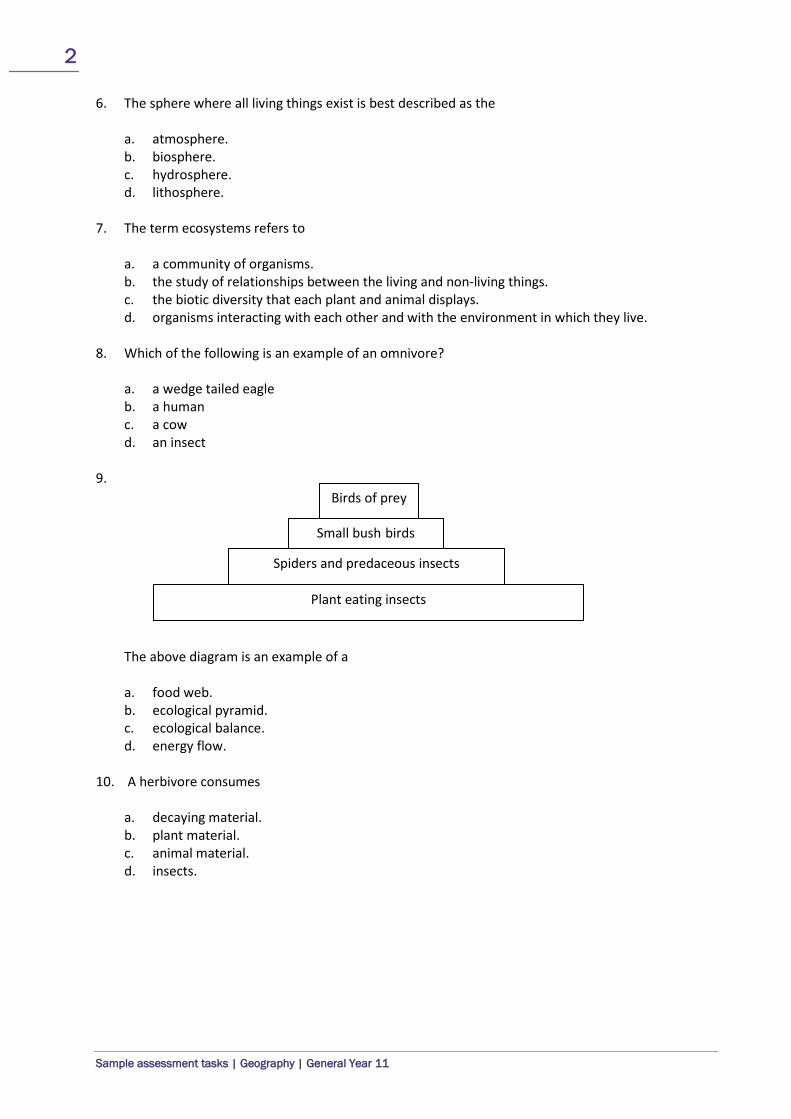
9.
The above diagram is an example of a a. food web. b. ecological pyramid. c. ecological balance. d. energy flow.
10. A herbivore consumes
a. decaying material. b. plant material. c. animal material. d. insects.
Birds of prey
Small bush birds
Spiders and predaceous insects
Plant eating insects

3
Sample assessment tasks | Geography | General Year 11
Questions 11, 12 and 13 refer to the following sequence. grass grasshopper lizard hawk 11. This sequence represents a
a. biosphere. b. food web. c. carbon cycle. d. food chain.
12. Which organism is located at the third trophic level?
a. hawk b. lizard c. grasshopper d. grass
13. Name the secondary consumer in the sequence above.
a. grass b. grasshopper c. lizard d. hawk
14. In general, as you move up the food chain
a. the number of animals usually increases. b. the number of animals usually decreases. c. the size of the animals usually stays the same. d. the size of the animal usually decreases.
15. Which of the following is not an example of the abiotic component of an ecosystem?
a. rocks b. soil c. atmosphere d. plants and animals

4
Sample assessment tasks | Geography | General Year 11
Section Two – Short answer (22 marks) 16. Identify if each of the following features is a natural or cultural feature. Tick the correct option.
(4 marks)
Feature Natural Cultural
beach
tropical rainforest
fruit orchard
pine tree plantation
buildings
coral reefs
roads
whales 17. Name four (4) biomes. (2 marks)
a. _______________________________
b. _______________________________
c. _______________________________
d. _______________________________
18. Choose one (1) biome and briefly describe:
• the location and distribution of the biome and
• the relationship between the climate and vegetation. (4 marks)
Biome: ______________________________
_________________________________________________________________________________
_________________________________________________________________________________
_________________________________________________________________________________
_________________________________________________________________________________
_________________________________________________________________________________
_________________________________________________________________________________
_________________________________________________________________________________
_________________________________________________________________________________

5
Sample assessment tasks | Geography | General Year 11
19. Briefly explain why it is important that we preserve biodiversity and don’t clear major areas of vegetation like the tropical rainforest. (4 marks)
_________________________________________________________________________________
_________________________________________________________________________________
_________________________________________________________________________________
_________________________________________________________________________________
_________________________________________________________________________________
_________________________________________________________________________________
_________________________________________________________________________________
_________________________________________________________________________________
20. Draw a diagram showing the three (3) interrelated parts (components) of an ecosystem. (3 marks)

6
Sample assessment tasks | Geography | General Year 11
21. Briefly explain the concept of sustainability and how it is being applied in the image below. (5 marks)
_________________________________________________________________________________
_________________________________________________________________________________
_________________________________________________________________________________
_________________________________________________________________________________
_________________________________________________________________________________
_________________________________________________________________________________
_________________________________________________________________________________
_________________________________________________________________________________
_________________________________________________________________________________
_________________________________________________________________________________
_________________________________________________________________________________
_________________________________________________________________________________
_________________________________________________________________________________
Total = 37 marks

7
Sample assessment tasks | Geography | General Year 11
Marking key for sample assessment task 2 – Unit 1
Section One – Multiple-choice
Question Answer Question Answer
1 D 9 B
2 B 10 B
3 A 11 D
4 C 12 B
5 D 13 C
6 B 14 B
7 D 15 D
8 B
Section Two – Short answer 16. Identify if each of the following features is a natural or cultural feature. Tick the correct option.
Description Marks
Correctly identifies the features 1–4
(½ mark for each correct feature)
Answer
Feature Natural Cultural beach tropical rainforest fruit orchard pine tree plantation buildings coral reefs roads whales
17. Name four (4) biomes.
Description Marks
Correctly names biomes 1–2
(½ mark for each) Answer could include, but is not limited to: • tropical forest • temperate forest • woodland • grassland • desert • tundra • alpine

8
Sample assessment tasks | Geography | General Year 11
18. Choose one (1) biome and briefly describe: • the location and distribution of the biome • the relationship between the climate and vegetation.
Description Marks The location and distribution of the biome Accurately describes the major location and distribution of their chosen biome Refers to specific countries and gives a range of latitudes to enhance their answer
2
Briefly describes the major location and distribution of their chosen biome Refers to one example of a specific country and either doesn’t give latitude or provides incorrect latitude
1
Subtotal 2 The relationship between the climate and vegetation Accurately describes the relationship between the climatic characteristics found in the biome and the vegetation Refers to specific climatic characteristics and vegetation types/characteristics
2
Describes in general terms that there is a relationship Does not include specific information for the selected biome
1
Subtotal 2 Total 4
Answer could include, but is not limited to: The location and distribution of the biome Tropical forests are distributed in areas of the world near the equator and between the Tropic of Capricorn and the Tropic of Cancer, normally between latitude 20 degrees north and south. Fifty seven percent of all tropical rainforests are found in Latin America. One third of the world's tropical rainforests are in Brazil. Other tropical rainforests are located in Southeast Asia and the Pacific Islands (25% of the world's tropical rainforests) and West Africa (18%). The relationship between the climate and vegetation Climatic conditions like temperature, rainfall and the amount of sunlight are important factors that control the type of vegetation found in a biome. Rainforests have high temperatures and high rainfall all year round and, as such have very tall evergreen trees. The dense vegetation found in the rainforest is a direct response to the humid equatorial climate and its year-round growing season.
19. Briefly explain why it is important that we preserve biodiversity and don’t clear major areas of
vegetation like the tropical rainforest.
Description Marks Clearly defines the concept of biodiversity (1) Refers to specific examples of either the importance of biodiversity or the negative impact of decreasing biodiversity (2) Uses geographical concepts such as food webs, sustainability and or climate change (1)
3–4
Provides a basic description of why biodiversity is important but does not use geographical concepts such as food webs, sustainability and/or climate change
1–2
Answer could include, but is not limited to: Biodiversity is defined as a number and variety of plant and animal species in a certain habitat, tropical rainforests have the highest levels of biodiversity, as compared with other place in the world. They regulate global climate patterns and help mitigate negative effects of climate change, specifically, global climate warming, and if we continue to lose biodiversity, we are going to lose out on potential discoveries of new foodstuffs, medicines, industrial raw materials.

9
Sample assessment tasks | Geography | General Year 11
20. Draw a diagram showing the three (3) interrelated parts (components) of an ecosystem.
Description Marks Constructs a well labelled diagram that accurately shows the interrelated parts and uses relevant geographical terminology and concepts (such as hydrosphere, atmosphere and lithosphere)
1–3 (1 mark for each
part)
21. Briefly explain the concept of sustainability and how it is being applied in the image below.
Description Marks Clearly defines the concept of sustainability 1–2 Clearly explains how sustainability principles have been applied in the image in terms of environmental, social and economic improvements
1–3
Total 5 Answer could include, but is not limited to: Sustainability involves meeting the needs of current and future generations through simultaneous environmental, social and economic adaptation and improvement. Wind power is a clean energy source that can be relied on for the long-term future. A wind turbine creates reliable, cost-effective, pollution free energy. It is affordable, clean and sustainable. One wind turbine can be sufficient to generate energy for a household. Because wind is a source of energy which is non-polluting and renewable, wind turbines create power without using fossil fuels, without producing greenhouse gases or radioactive or toxic waste. Wind power reduces global warming.

10
Sample assessment tasks | Geography | General Year 11
Sample assessment task
Geography – General Year 11
Task 4: Part B – Unit 1
Assessment type: Fieldwork/Practical skills Conditions Time for the task: 50 minutes All questions are based on fieldwork undertaken at South Trigg–North Beach Notes can be referred to but no talking or communicating with other students is permitted Task weighting 15% of the school mark for this pair of units __________________________________________________________________________________ 1. Draw a vertical sketch of Trigg Beach showing the following features:
• Trigg Island • swale • wave-cut platform • primary dune • stacks • vehicle access ramp • berm • public toilets and bins • foredune • dune vegetation
(7 marks) Title: _______________________________________________

11
Sample assessment tasks | Geography | General Year 11
2. Identify the type of coastal landform of which Trigg Island is an example. (1 mark) _____________________________________________________________________________________ 3. Wave-cut platforms are produced by wave erosion. With the aid of an annotated sketch, briefly
describe the processes responsible for its formation. (3 marks) _____________________________________________________________________________________
_____________________________________________________________________________________
_____________________________________________________________________________________
_____________________________________________________________________________________
_____________________________________________________________________________________
_____________________________________________________________________________________
4. Describe the process of attrition. (2 marks) _____________________________________________________________________________________
_____________________________________________________________________________________
_____________________________________________________________________________________
_____________________________________________________________________________________
5. An understanding of longshore drift would be considered vital to councils wanting to arrest the erosion of precious sand from a popular tourist beach. With the aid of a fully labelled sketch and specific reference to fieldwork, explain the process of longshore drift and how it can be harnessed to save a beach. (7 marks)

12
Sample assessment tasks | Geography | General Year 11
_____________________________________________________________________________________
_____________________________________________________________________________________
_____________________________________________________________________________________
_____________________________________________________________________________________
_____________________________________________________________________________________
_____________________________________________________________________________________
_____________________________________________________________________________________
_____________________________________________________________________________________
_____________________________________________________________________________________
_____________________________________________________________________________________
_____________________________________________________________________________________
6. List four (4) characteristics of destructive waves. (4 marks)
• ________________________________________________
• ________________________________________________
• ________________________________________________
• ________________________________________________
7 a) Name two (2) erosional coastal landforms or features. (4 marks)
• ________________________________________________
• ________________________________________________
b) Name two (2) depositional landforms or features.
• ________________________________________________
• ________________________________________________
8. Identify three (3) ways sand dunes are being rehabilitated at Trigg Beach. (3 marks)
• ________________________________________________
• ________________________________________________
• ________________________________________________

13
Sample assessment tasks | Geography | General Year 11
9. a) Explain two (2) reasons why vegetation is important to the stability of the dune system. (2 marks)
Reason 1:
_____________________________________________________________________________________
_____________________________________________________________________________________
Reason 2:
_____________________________________________________________________________________
_____________________________________________________________________________________
b) Identify two (2) ways that dune vegetation is being threatened and/or destroyed. (2 marks)
• ________________________________________________
• ________________________________________________
10. Briefly explain why beaches disappear during winter. (2 marks) _____________________________________________________________________________________
_____________________________________________________________________________________
_____________________________________________________________________________________
_____________________________________________________________________________________
11. Label the coastal landforms in the spaces provided. (3 marks)
<coastal diagram to be included by teacher in this space>
14
Sample assessment tasks | Geography | General Year 11
Marking key for sample assessment task 4 – Unit 1
1. Draw a vertical sketch of Trigg Beach.
Description Marks Draws an accurate vertical sketch of Trigg Beach 1–2
Correctly identifies the features 1–5
(½ mark each) Total 7
2. Identify the type of coastal landform of which Trigg Island is an example.
Description Marks Correctly identifies that Trigg Island is a tombolo 1
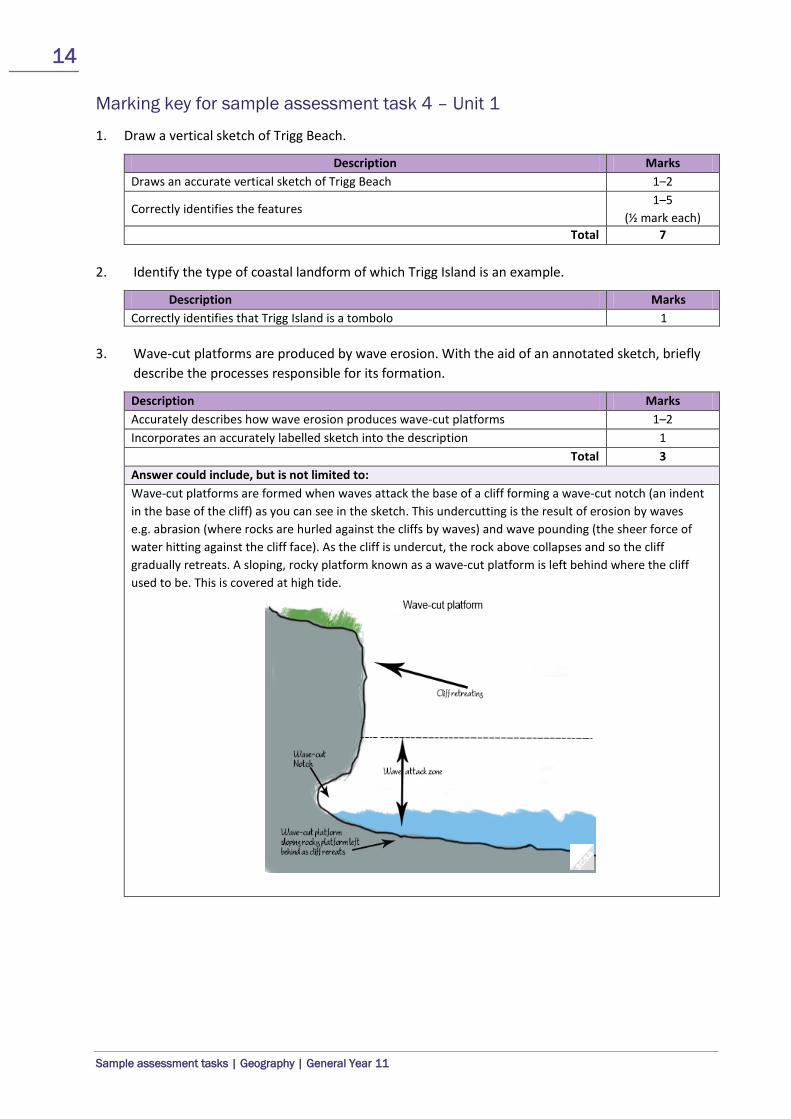
3. Wave-cut platforms are produced by wave erosion. With the aid of an annotated sketch, briefly
describe the processes responsible for its formation.
Description Marks Accurately describes how wave erosion produces wave-cut platforms 1–2 Incorporates an accurately labelled sketch into the description 1
Total 3 Answer could include, but is not limited to: Wave-cut platforms are formed when waves attack the base of a cliff forming a wave-cut notch (an indent in the base of the cliff) as you can see in the sketch. This undercutting is the result of erosion by waves e.g. abrasion (where rocks are hurled against the cliffs by waves) and wave pounding (the sheer force of water hitting against the cliff face). As the cliff is undercut, the rock above collapses and so the cliff gradually retreats. A sloping, rocky platform known as a wave-cut platform is left behind where the cliff used to be. This is covered at high tide.

15
Sample assessment tasks | Geography | General Year 11
4. Describe the process of attrition.
Description Marks Accurately defines attrition (with relation to coastal geography) 1 Includes an example 1
Total 2 Answer could include, but is not limited to: • The wearing away or fragmentation of particles of debris by contact with other such particles, as with
river pebbles or broken rock from cliffs and notches. • The wearing or rubbing away by the friction of a particle or particles against another. When particles
such as sand, or even large rocks, are transported by rivers, waves, wind or even glaciers, the particles are worn down by their rubbing against each other.
5. An understanding of longshore drift would be considered vital to councils wanting to arrest the
erosion of precious sand from a popular tourist beach. With the aid of a fully labelled sketch and specific reference to fieldwork, explain the process of longshore drift and how it can be harnessed to save a beach.
Description Marks Provides a well written explanation of the process of longshore drift and how it can be harnessed to save a beach 1–3
Refers to specific examples from fieldwork 1–2 Provides a fully labelled sketch 1–2
Total 7 Answer could include, but is not limited to: Longshore drift is the movement of sand along the coastline. This movement of sand is influenced by the surf zone currents created by waves and the predominant wave direction. Under these conditions, waves break at an angle to the shoreline (forming oblique waves) and the sand is moved along the beach in the surf zone. The direction the sand moves in depends on the dominant wave direction. The construction of groynes and seawalls as we saw at Sorrento and Hillary’s boat harbour are used to prevent sand from being removed from a particular part of the coastline.
6. List four (4) characteristics of destructive waves.
Description Marks
Lists characteristics of destructive waves 1–4 (1 mark each)
Answer could include, but is not limited to: • frequent in number (usually between 10–15 per minute) • high energy • forms a steep, narrow beach, scouring out the berm in front • weak swash, brings very little material to shore • backwash is much stronger than their swash, thus allowing them to remove material from the berm • tall waves, meaning they have a greater distance to fall, creating a greater impact upon contact to
surface

16
Sample assessment tasks | Geography | General Year 11
7. a) Name two (2) erosional coastal landforms or features.
Description Marks
Names erosional coastal landforms or features 1–2 (1 mark each)
Answer could include, but is not limited to: • natural arch • stack • cave • notch • blowhole • wave-cut platform • headland • bay
b) Name two (2) depositional landforms or features.
Description Marks
Names depositional landforms or features 1–2 (1 mark each)
Answer could include, but is not limited to: • beaches • sand spit • bars • barrier Island • tombolo • cuspate foreland
8. Identify three (3) ways sand dunes are being rehabilitated at Trigg Beach.
Description Marks
Identifies ways sand dunes are being rehabilitated at Trigg Beach 1–3 (1 mark each)
Answer could include, but is not limited to: • fencing • signs • erection of wooden stairs to control pedestrian traffic direction and extent
9 a) Briefly explain two (2) reasons why vegetation is important to the stability of the dune system.
Description Marks Briefly explains reasons why vegetation is important to the stability of the dune system
1–2 (1 mark each)
Answer could include, but is not limited to: • The roots of dune vegetation hold sand grains in place and prevent the grains from blowing away. • Dune vegetation traps sand grains during wind and human endeavours across dunes.

17
Sample assessment tasks | Geography | General Year 11
b) Identify two (2) ways that dune vegetation is being threatened and/or destroyed.
Description Marks
Identifies ways dune vegetation is being threatened and/or destroyed 1–2 (1 mark each)
Answer could include, but is not limited to: • fauna (wild and domestic) • human activity (foraging, trekking, camping etc.) • pollution (litter)
10. Briefly explain why beaches disappear during winter.
Description Marks Briefly explains why beaches disappear during winter 1–2 Answer could include, but is not limited to: More destructive waves (number and frequency) ‘destroy’ the berm during winter
11. Label the coastal landforms in the spaces provided.
Description Marks
Correctly labels the coastal landforms 1–3 (½ mark each)
Answer Will depend on the diagram included by the teacher

18
Sample assessment tasks | Geography | General Year 11
Sample assessment task
Geography – General Year 11
Task 8 – Unit 2
Assessment type: Geographical inquiry
Conditions Period allowed for completion of the task: 4 weeks Task weighting 15% of the school mark for this pair of units _____________________________________________________________________________________ Investigate one (1) of the following resources in the context of the Collie region:
• soil • water • air • minerals • heritage areas/sacred sites
The emphasis is on the sustainable use/development of the resource. Include the following aspects when investigating the resource:
1. the stakeholders who would be potentially affected by the issue and their views and attitudes towards the issue
2. how the various responses to the issue are likely to lead to sustainable management practices
3. the impact that changing flows of people (such as tourists, employees, retirees etc.) may have on sustainable management practices.
Part A: Geographical inquiry process (11 marks = 7.5%)
During the investigation, use your Geographical inquiry skills to:
• Devise and present a plan for the inquiry which includes aims, inquiry questions, and methodology. (4 marks)
• Create/collect/devise primary sources (e.g. interviews, questionnaires, student’s own experiences, field observations including photos or video on a smart phone, sources created using spatial technologies such as GIS, GPS, and Google maps) and locate secondary sources (e.g. online maps, links to websites, text from online or print sources, satellite images). (4 marks)
• Select relevant evidence from your sources and record this in an organised manner. (3 marks)
• Follow the school’s protocol to create a bibliography. (2 marks)
Part B: Class presentation (25 marks = 7.5%)
• Prepare a 5–10 minute oral or multimedia presentation which:
addresses the three required aspects (15 marks)

19
Sample assessment tasks | Geography | General Year 11
uses evidence from the collected information, data and maps to support your findings/conclusion (3 marks)
refers to relevant geographical information (including examples, quotes from sources, sketches and/or diagrams), data (tables, graphs) and maps (4 marks)
uses geographical terminology and concepts. (3 marks)

20
Sample assessment tasks | Geography | General Year 11
Marking key for sample assessment task 8 – Unit 2
Part A: Geographical inquiry process (7.5%)
Description Marks Planning Presents a clear plan which includes clearly defined aims, geographical inquiry questions, and appropriate methodology 3–4
Presents a limited and/or generalised plan which includes some geographical inquiry questions, and some indication of methodology 1–2
Subtotal 4 Sources/notes Creates/collects/devises a range of primary and secondary sources which are relevant, the inquiry topic 3–4
Creates/collects/devises a limited range of primary and/or secondary sources which may not be relevant to the topic 1–2
Subtotal 4 Collection of evidence Information, data and maps is recorded in a well organised manner (e.g. using appropriate frameworks) 3
Information, data and maps is recorded in an organised manner (e.g. using a simple framework) 2
Information, data and maps is recorded but shows limited organisation and no use of any frameworks 1
Subtotal 3 Bibliography Follows correct format according to the school protocols 2 Lists sources used 1
Subtotal 2 Total Part A 13

21
Sample assessment tasks | Geography | General Year 11
Part B: Class presentation (7.5%)
Description Marks Aspect 1 – Stakeholders and their views and attitudes Identifies multiple relevant stakeholders and clearly outlines their views and attitudes towards the development and sustainability of the selected resource 4–5
Identifies a few relevant stakeholders and briefly outlines their views and attitudes towards the development and sustainability of the selected resource 2–3
Makes a generalised statement about the stakeholders without providing any information on their views or attitudes towards the development and sustainability of the selected resource
1
Subtotal 5 Aspect 2 – Responses to the issue Clearly describes several responses to the issue and how they are likely to lead to sustainable management practices 4–5
Identifies one or two responses to the issue without clearly describing how they are likely to lead to sustainable management practices 2–3
Makes a generalised statement about responses to the issue without making any link to sustainable management practices 1
Subtotal 5 Aspect 3 – Impact of a changing flow of people Discusses the impact that the changing flow of people may have on sustainable management practices in the region 4–5
Briefly outlines one or two of the impacts that the changing flow of people may have on the region and attempts to link them to the sustainable management practices in the region
2–3
Makes a generalised statement about the impact the changing flow of people may have on the region 1
Subtotal 5 Findings/conclusion Supported by reference to a range of relevant evidence and examples 3 Supported by some reference to evidence and examples 2 Generalised conclusion with no supporting evidence OR Evidence provided does not support the findings/conclusion
1
Subtotal 3 Reference to geographical information, data and maps Refers to relevant geographical information (including examples, quotes from sources, sketches, diagrams), data (tables, graphs) and maps in a meaningful way to develop and enhance explanations
3–4
Makes limited reference to relevant geographical information, data and maps not always linked to explanations 1–2
Subtotal 4 Use of geographical terminology and concepts Correctly uses relevant geographical terminology and concepts not always in the appropriate context 3
Limited use of geographical terminology and concepts 2 Rarely and/or inaccurately uses geographical terminology and/or concepts 1
Subtotal 3 Total Part B 25