salinas valley: groundwater sustainability plan · the salinas valley basin groundwater...
TRANSCRIPT


DRAFT
Salinas Valley:
180/400-Foot Aquifer Subbasin
Groundwater Sustainability Plan
Chapters 1-3
Prepared for:
Salinas Valley Basin Groundwater Sustainability Agency
November 2018
Prepared by:
DRAFT

This page left
intentionally blank

DRAFT
180/400-Foot Aquifer Subbasin GSP
January, 2020 - i -
TABLE OF CONTENTS
Abbreviations and Acronyms .................................................................................... iv
Section 1 Introduction to the 180/400-Foot Aquifer Subbasin Groundwater
Sustainability Plan ....................................................................................................... 1
1.1 Purpose of the Groundwater Sustainability Plan ................................................................... 1
1.2 Description of the 180/400-Foot Aquifer Subbasin ................................................................. 2
Section 2 Agency Information ..................................................................................... 4
2.1 Agency Names and Mailing Addresses ................................................................................... 6
2.2 Agencies’ Organization and Management Structure ............................................................. 6
2.2.1 SVBGSA .................................................................................................................................. 6
2.2.2 MCWD .................................................................................................................................... 7
2.3 Authority of Agency/Agencies .................................................................................................. 7
2.3.1 Individual GSAs .................................................................................................................... 7
2.3.2 Coordination Agreement/MOA .......................................................................................... 9
2.4 Contact information for Plan Manager ..................................................................................... 9
Section 3 Description of Plan Area ........................................................................... 10
3.1 180/400-Foot Aquifer Subbasin Introduction ........................................................................ 10
3.2 Adjudicated Areas, Other GSAs, and Alternatives .............................................................. 10
3.3 Jurisdictional Areas ................................................................................................................... 13
3.3.1 Federal Jurisdiction ............................................................................................................. 13
3.3.2 State Jurisdiction ................................................................................................................. 13
3.3.3 County Jurisdiction ............................................................................................................. 13
3.3.4 City and Local Jurisdiction ................................................................................................ 13
3.4 Land Use ..................................................................................................................................... 16
3.4.1 Water Source Types ............................................................................................................ 18
3.4.2 Water Use Sectors ............................................................................................................... 20
3.5 Existing Well Types, Numbers, and Density ......................................................................... 21
3.6 Existing Monitoring Programs ................................................................................................ 25
3.6.1 Existing Groundwater Level Monitoring ........................................................................ 25
3.6.2 Groundwater Extraction Monitoring ............................................................................... 27
3.6.3 Groundwater Quality Monitoring .................................................................................... 27
3.6.4 Surface Water Monitoring ................................................................................................. 28
3.6.5 Incorporating Existing Monitoring Programs Into the GSP ......................................... 31
3.6.6 Limits to Operational Flexibility ....................................................................................... 31
3.7 Existing Management Plans ..................................................................................................... 31

DRAFT
180/400-Foot Aquifer Subbasin GSP
January, 2020 - ii -
3.7.1 Monterey County Groundwater Management Plan ..................................................... 31
3.7.2 Integrated Regional Water management Plan ................................................................ 32
3.7.3 Urban Water Management Plans ..................................................................................... 34
3.8 Existing Groundwater Regulatory Programs ........................................................................ 36
3.8.1 Groundwater Export Prohibition ..................................................................................... 36
3.8.2 Agricultural Order .............................................................................................................. 37
3.8.3 Water Quality Control Plan for the Central Coast Basins ............................................. 37
3.8.4 Requirements for New Wells ............................................................................................ 38
3.8.5 Title 22 Drinking Water Program ..................................................................................... 38
3.8.6 Incorporating Regulatory Programs Into the GSP ......................................................... 39
3.8.7 Limits to Operational Flexibility ....................................................................................... 39
3.9 Conjunctive Use Programs ....................................................................................................... 39
3.9.1 Monterey County Water Recycling Projects ................................................................... 39
3.9.2 Regional Urban Water Augmentation Project ................................................................ 40
3.10 Land Use Plans ......................................................................................................................... 40
3.10.1 Monterey County General Plan ...................................................................................... 40
3.10.2 City of Salinas General Plan ............................................................................................ 46
3.10.3 City of Gonzales General Plan ........................................................................................ 48
3.10.4 City of Marina General Plan ............................................................................................ 50
3.10.5 Well Permitting ................................................................................................................. 50
3.10.6 County Moratorium on Accepting and Processing New Well Permits. ................... 50
3.10.7 Land Use Plans Outside of Basin .................................................................................... 53
3.10.8 Plan Implementation Effects on Existing Land Use .................................................... 53
3.10.9 Plan Implementation Effects on Water Supply ............................................................ 53

DRAFT
180/400-Foot Aquifer Subbasin GSP
January, 2020 - iii -
LIST OF FIGURES
Figure 1-1: 180/400-Foot Aquifer Subbasin ........................................................................................ 3
Figure 2-1: Map of Areas Covered by GSAs and Overlap Areas ................................................... 5
Figure 3-1: Area Covered by GSP ...................................................................................................... 11
Figure 3-2: Location of the Adjudicated Seaside Subbasin ............................................................ 12
Figure 3-3: Map of Federal and State Groundwater Jurisdictional Areas ................................... 14
Figure 3-4: City, CSD, and Water District Jurisdictional Areas ................................................... 15
Figure 3-5: Existing Land Use Designations (from DWR) ............................................................. 17
Figure 3-6: Municipal Areas Dependent on Groundwater and the CSIP Distribution Area ... 19
Figure 3-7: Density of Domestic Wells per Square Mile ................................................................ 22
Figure 3-8: Density of Agricultural Production Wells per Square Mile ...................................... 23
Figure 3-9 Density of Municipal Wells per Square Mile ................................................................ 24
Figure 3-10: Locations of CASGEM Wells in the 180/400-Foot Aquifer Subbasin ..................... 26
Figure 3-11: Locations of USGS GAMA Wells in the 180/400-Foot Aquifer Subbasin .............. 29
Figure 3-12: Surface Water Gaging Locations ................................................................................ 30

DRAFT
180/400-Foot Aquifer Subbasin GSP
January, 2020 - iv -
LIST OF TABLES
Table 3-1: Land use summary ............................................................................................................ 16
Table 3-2: Well count summary ......................................................................................................... 21
Table 3-3 Monterey County General Plan Summary ..................................................................... 40
Table 3-4: Monterey County Population Projections ...................................................................... 46
Table 3-5: City of Salinas General Plan Summary........................................................................... 46
Table 3-6: City of Gonzales General Plan Summary ....................................................................... 48
Table 3-7: Monterey County Water Supply Guidelines for New Lots ......................................... 52
Table 3-8: Monterey County Well Permitting Guidelines for Existing Lots ............................... 53
ABBREVIATIONS AND ACRONYMS
AFY ................................................... Acre-Feet per Year
AMBAG ............................................ Association of Monterey Bay Area Governments
CASGEM .......................................... California Statewide Groundwater Elevation Monitoring
CCR ................................................... California Code of Regulations
CCRWQCB ....................................... Central Coast Regional Water Quality Control Board
CIFP .................................................. Capital Improvement and Financing Plan
CSD ................................................... Community Services District
CSIP ................................................... Castroville Seawater Intrusion Project
DDW ................................................. Division of Drinking Water
DWR .................................................. Department of Water Resources
GAMA .............................................. Groundwater Ambient Monitoring and Assessment
GRC ................................................... General Rate Case
GMP .................................................. Groundwater Management Plan
GSA ................................................... Groundwater Sustainability Agency
GSP .................................................... Groundwater Sustainability Plan
ILRP .................................................. Irrigated Lands Regulatory Program
IRWM................................................ Integrated Regional Water Management
JPA .................................................... Joint Powers Authority
MCL .................................................. Maximum Contaminant Level
MCWD .............................................. Marina Coast Water District
MCWRA ........................................... Monterey County Water Resources Association
MPWSP ............................................. Monterey Peninsula Water Supply Project
NPDES .............................................. National Pollutant Discharge Elimination System
RWMG .............................................. Regional Water Management Group
SB ....................................................... Senate Bill
SGMA ............................................... Sustainable Groundwater Management Act
DRAFT
180/400-Foot Aquifer Subbasin GSP
January, 2020 - v -
SRDF ................................................. Salinas River Diversion Facility
SVBGSA ............................................ Salinas Valley Basin Groundwater Sustainability Agency
SVRP ................................................. Salinas Valley Reclamation Project
SVWP ................................................ Salinas Valley Water Project
SWQCB ............................................. State Water Quality Control Board
UWMP .............................................. Urban Water Management Plan
USGS ................................................. United States Geological Survey
WDR .................................................. Waste Discharge Requirements
DRAFT
180/400-Foot Aquifer Subbasin GSP
January, 2020 - 1 -
SECTION 1 INTRODUCTION TO THE 180/400-FOOT AQUIFER SUBBASIN
GROUNDWATER SUSTAINABILITY PLAN
1.1 PURPOSE OF THE GROUNDWATER SUSTAINABILITY PLAN
In 2014, the State of California enacted the Sustainable Groundwater Management Act
(SGMA). This law required groundwater basins or subbasins that are designated as medium
or high priority to be managed sustainably. The Salinas Valley Groundwater Basin
comprises seven subbasins. The subject of this report is one of those subbasins, known as the
180-400-Foot Aquifer Subbasin.
Satisfying the requirements of SGMA generally requires four basic activities:
1. Forming one or more Groundwater Sustainability Agency(s) (GSAs) in the basin
2. Developing a Groundwater Sustainability Plan (GSP)
3. Implementing the GSP and managing to measurable, quantifiable objectives
4. Regular reporting to the California Department of Water Resources (DWR)
A Groundwater Sustainability Agency (GSA) is a local agency responsible for developing the
GSP for its area of responsibility. The Salinas Valley Basin Groundwater Sustainability
Agency (SVBGSA) is a GSA that was formed in 2017. The SVBGSA represents agriculture,
public utility, municipal, county, and environmental stakeholders and is responsible for
developing GSPs in much of the Salinas Valley.
This document satisfies the GSP requirement for the Salinas Valley – 180/400-Foot Aquifer
Subbasin (Subbasin or 180/400-Foot Subbasin). The GSP describes the Subbasin, establishes
local sustainable management criteria and provides projects and programs for reaching
sustainability in the Subbasin by 2040. The GSP also includes monitoring and reporting
protocols to document long-term sustainable management in the Subbasin.
The Salinas Valley Basin Groundwater Sustainability Agency (SVBGSA) developed this GSP
with coordination from the Marina Coast Water District (MCWD) GSA. This GSP is
developed in concert with GSPs for five other Salinas Valley subbasins under SVBGSA
jurisdiction: the East Side Aquifer Subbasin (DWR subbasin number 3-004.02), the Forebay
Aquifer Subbasin (DWR subbasin number 3-004.04), the Upper Valley Aquifer Subbasin
(DWR subbasin number 3-004.05), the Langley Area Subbasin (DWR subbasin number 3-
004.09) and the Monterey Subbasin (DWR subbasin number 3-004.10). The projects and
programs presented in this GSP are part of a cohesive set of projects and programs designed
to achieve sustainability throughout the entire Salinas Valley groundwater basin.
DRAFT
180/400-Foot Aquifer Subbasin GSP
January, 2020 - 2 -
1.2 DESCRIPTION OF THE 180/400-FOOT AQUIFER SUBBASIN
The 180/400-Foot Aquifer Subbasin is identified by DWR as Subbasin 3-004.01. The Subbasin
is part of the greater Salinas Valley groundwater Basin in the Central Coastal region of
California (DWR, 2016). The Subbasin is named for its two primary water-bearing units: the
180-Foot Aquifer and the 400-Foot Aquifer. The Subbasin encompasses an area of
approximately 84,400 acres, or 132 square miles. The subbasin lies in Monterey County and
contains parts of the urban areas of Salinas, Castroville, Moss Landing, Marina, Chualar, and
Gonzales (Figure 1-1). The subbasin is bounded by Monterey Bay to the northwest.
Five groundwater subbasins adjoin the 180/400-Foot Subbasin (Figure 1-1).
• The Corralitos - Pajaro Valley Basin is located along the northern Subbasin boundary.
The boundary between with the Corralitos – Pajaro Valley Basin coincides with the
inland projection of a clay-filled paleodrainage of the Salinas River buried beneath
Elkhorn Slough which acts as a flow barrier between the basins (DWR, 2004).
• The East Side Subbasin is located along most of the northeastern boundary of the
Subbasin. There is some, although potentially limited, hydraulic communication
between the Eastside Subbasin and the 180/400-Foot Aquifer subbasin.
• The Langley Area Subbasin is located along a short length of the northeastern
boundary of the Subbasin.
• The Forebay Aquifer Subbasin is located along the southeastern boundary, near the
city of Gonzales. The boundary is the approximate limit of confining conditions in the
up-valley direction (DWR, 2004).
• The Monterey Subbasin is located along the southwestern boundary of the Subbasin.
The boundary roughly follows portions of the Reliz fault and a groundwater divide.
All five surrounding subbasins are high priority and are required to develop GSPs under
SGMA by January 31, 2022. GSPs for the East Side Subbasin and Langley Area Subbasin will
be developed by the SVBGSA. The GSP for the Forebay Subbasin will be developed [to be
finalized]. The GSP for the Monterey Subbasin will be developed jointly by the SVBGSA and
the MCWD GSA. An alternative submittal for a GSP has been submitted for the Corralitos –
Pajaro Valley Basin by the Pajaro Valley Water Management Agency.

DRAFT
180/400-Foot Aquifer Subbasin GSP
January, 2020 - 3 -
Figure 1-1: 180/400-Foot Aquifer Subbasin

DRAFT
180/400-Foot Aquifer Subbasin GSP
January, 2020 - 4 -
SECTION 2 AGENCY INFORMATION
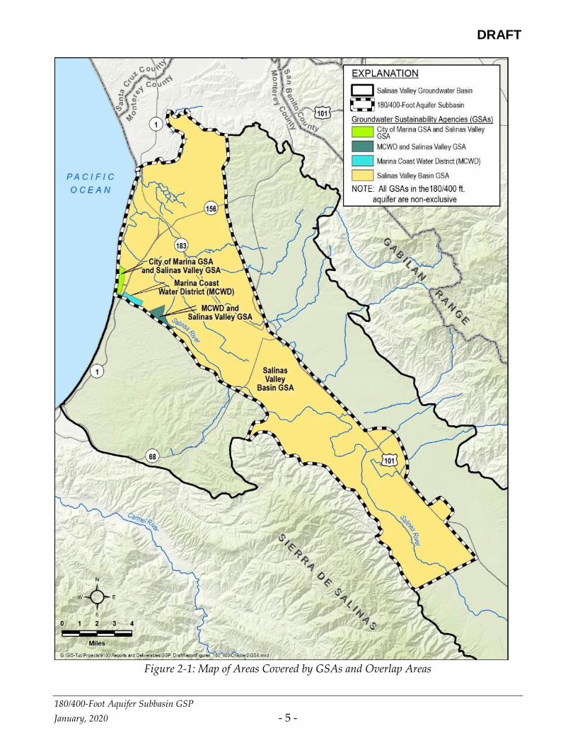
Three GSAs cover the 180/400-Foot Aquifer Subbasin: the SVBGSA, the MCWD GSA, and the
City of Marina GSA. DWR considers none of these three GSAs to be exclusive GSAs for the
entire Subbasin; however, MCWD is an exclusive GSA for that portion of the Subbasin within
its jurisdictional boundaries. The City of Marina GSA was not submitted during the required
filing period, and therefore the City of Marina may not be a valid GSA. The 180/400-Foot
Aquifer Subbasin GSP was developed by the SVBGSA with input and assistance from the
MCWD GSA. Both GSAs are signatories of the GSP.
The jurisdictional areas of all three GSAs in relation to the Subbasin boundary are shown on
Figure 2-1.
DRAFT
180/400-Foot Aquifer Subbasin GSP
January, 2020 - 5 -
Figure 2-1: Map of Areas Covered by GSAs and Overlap Areas
DRAFT
180/400-Foot Aquifer Subbasin GSP
January, 2020 - 6 -
2.1 AGENCY NAMES AND MAILING ADDRESSES
The following contact information is provided for each GSA that is a signatory to this GSP,
pursuant to California Water Code § 10723.8.
Salinas Valley Groundwater Sustainability Agency
Attn.: Gary Petersen, General Manager
1441 Schilling Place
Salinas, CA 93901
https://svbgsa.org
Marina Coast Water District Groundwater Sustainability Agency
Attn.: Keith Van Der Maaten, General Manager
11 Reservation Road
Marina, CA 93933
http://www.mcwd.org
2.2 AGENCIES’ ORGANIZATION AND MANAGEMENT STRUCTURE
2.2.1 SVBGSA
The SVBGSA is a Joint Powers Authority (JPA). The JPA membership comprises the County
of Monterey, Water Resources Agency of Monterey County, City of Salinas, City of Soledad,
City of Gonzales, City of King, the Castroville Community Services District (CSD), and
Monterey One Water (formerly the Monterey Regional Water Pollution Control Agency). The
SVBGSA is governed and administered by an eleven-member Board of Directors,
representing public and private groundwater interests throughout the Valley. When a
quorum is present, a Majority Vote is required to conduct business. Some business items
require a Super Majority Vote or a Super Majority Plus Vote. A Super Majority requires an
affirmative vote by eight of the eleven Board members. A Super Majority Vote is required
for:
• Approval of a GSP
• Amendment of budget and transfer of appropriations
• Withdrawal or termination of Agency members
A Super Majority Plus requires an affirmative vote by eight of the eleven Board members,
including an affirmative vote by three of the four agricultural representatives. A Super
Majority Plus Vote is required for:
DRAFT
180/400-Foot Aquifer Subbasin GSP
January, 2020 - 7 -
• Decisions to impose fees not requiring a vote of the electorate or property owners
• Proposals to submit to the electorate or property owners’ decisions to impose fees or
taxes
• Limitations on well extractions (pumping limits)
In addition to the Board of Directors, SVBGSA includes an Advisory Committee consisting of
Directors and non-Directors. The Advisory Committee is designed to ensure participation by,
and input to, the Board of Director by constituencies whose interests are not directly
represented on the Board. The SVBGSA’s GSA activities are staffed by a contract General
Manager.
2.2.2 MCWD
MCWD is governed by a five-member Board of Directors who each serve four-year terms.
Board members are elected at large. Decisions on all GSA-related matters require an
affirmative vote of a majority of the five Board of Directors members. The MCWD’s GSA
activities are staffed by the MCWD’s existing staff.
2.3 AUTHORITY OF AGENCY/AGENCIES
2.3.1 INDIVIDUAL GSAS
Both GSAs involved in the development of this GSP were formed in accordance with the
requirements of California Water Code § 10723 et seq. The resolutions of formation for both
GSAs are included in Appendix A. Each agency’s specific authorities for GSA formation and
groundwater management are listed below.
2.3.1.1 SVBGSA
SVBGSA is a JPA that was formed in accordance with the requirements of California
Government Code § 6500 et seq. In accordance with California Water Code § 10723 et seq, the
JPA signatories are all cities, counties, and water agencies with water or land use authority
and are all independently eligible to serve as GSAs:
• The County of Monterey has land use authority over the unincorporated areas of the
County, including areas overlying the 180/400-Foot Aquifer Subbasin. The County of
Monterey is therefore a local agency under California Water Code § 10721 with the
authority to establish itself as a GSA.
• The Monterey County Water Resources Agency is a California Special Act District
with broad water management authority in Monterey County. The Monterey County

DRAFT
180/400-Foot Aquifer Subbasin GSP
January, 2020 - 8 -
Water Resources Agency is therefore a local agency under California Water Code §
10721 with the authority to establish itself as a GSA.
• The City of Salinas is incorporated under the laws of the State of California. The City
provides water supply and land use planning services to its residents. The City is
therefore a local agency under California Water Code § 10721 with the authority to
establish itself as a GSA.
• The City of Soledad is incorporated under the laws of the State of California. The City
provides water supply and land use planning services to its residents. The City is
therefore a local agency under California Water Code § 10721 with the authority to
establish itself as a GSA.
• The City of Gonzales is incorporated under the laws of the State of California. The
City provides water supply and land use planning services to its residents. The City is
therefore a local agency under California Water Code § 10721 with the authority to
establish itself as a GSA.
• The City of King is incorporated under the laws of the State of California. The City
provides water supply and land use planning services to its residents. The City is
therefore a local agency under California Water Code § 10721 with the authority to
establish itself as a GSA.
• The Castroville Community Services District is a local public agency of the State of
California, organized and operating under the Community Services District Law,
Government Code § 6100 et seq. Castroville CSD provides water services to its
residents. Castroville CSD is therefore a local agency under California Water Code §
10721 with the authority to establish itself as a GSA.
• Monterey One Water is itself a joint powers authority whose members include many
members of the SVBGSA. Monterey One Water is a local agency under California
Water Code § 10721 with authority to establish itself as a GSA.
Upon establishing itself as a GSA, the SVBGSA retains all the rights and authorities provided
to GSAs under California Water Code § 10725 et seq. as well as the powers held in common
by the members.
2.3.1.2 MCWD
MCWD was formed in accordance with California Water District Law, California Water Code
§ 34000, and is responsible for water supply in a portion of the Subbasin. MCWD is therefore
a local agency under California Water Code § 10721 with the authority to establish itself as a
GSA. Upon establishing itself as a GSA, MCWD retains all the rights and authorities
provided to GSAs under California Water Code § 10725 et seq.
DRAFT
180/400-Foot Aquifer Subbasin GSP
January, 2020 - 9 -
2.3.2 COORDINATION AGREEMENT/MOA
To be Completed After Agreements Signed
2.4 CONTACT INFORMATION FOR PLAN MANAGER
Mr. Gary Petersen, General Manager
Salinas Valley Groundwater Sustainability Agency
P.O. Box 1350
Carmel Valley, CA 93924 (831) 682-2592
https://svbgsa.org

DRAFT
180/400-Foot Aquifer Subbasin GSP
January, 2020 - 10 -
SECTION 3 DESCRIPTION OF PLAN AREA
3.1 180/400-FOOT AQUIFER SUBBASIN INTRODUCTION
This GSP covers the entire 180/400-Foot Aquifer Subbasin, as shown on Figure 3-1. The
Subbasin lies in northwestern Monterey County and includes the northern end of the Salinas
River Valley. The Subbasin covers an area of 84,400 acres (132 square miles) (DWR, 2004). The
boundaries of the Subbasin, combined with those of the Monterey and Seaside subbasins, are
generally consistent with the Monterey County Water Resource Agency’s (MCWRA)
Pressure Subarea (MCWRA, 2006).
The Salinas River drains the Subbasin, discharging into Monterey Bay. The Subbasin contains
the municipalities of Marina, Salinas and Gonzales and the census-designated places of
Castroville, Moss Landing, Elkhorn, Boronda, Spreckels, and Chualar. United States
Highway 101 runs north-south along the eastern border of the Subbasin. State Highways 1,
156, 183, and 68 also cross the subbasin. Rivers and streams, urban areas, and major roads are
shown on Figure 3-1.
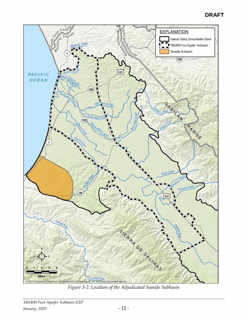
3.2 ADJUDICATED AREAS, OTHER GSAS, AND ALTERNATIVES
The Subbasin is not adjudicated. The only adjudicated area in the Salinas Valley Basin is the
Seaside Subbasin (3-004.08), which is not adjacent to the 180/400-Foot Aquifer Subbasin. The
adjudicated Seaside Subbasin is shown by the shaded area on Figure 3-2.
The City of Marina is the only entity that claims to be a non-exclusive GSA in the Subbasin
and is not a party to this GSP. As discussed earlier, the validity of the City of Marina’s GSA
application has yet to be definitively determined. Figure 2-1 shows the area within the
180/400-Foot Aquifer Subbasin covered by the City of Marina GSA. No alternative plans
have been submitted for any part of the Subbasin, or for any other Salinas Valley subbasin.

DRAFT
180/400-Foot Aquifer Subbasin GSP
January, 2020 - 11 -
Figure 3-1: Area Covered by GSP
DRAFT
180/400-Foot Aquifer Subbasin GSP
January, 2020 - 12 -
Figure 3-2: Location of the Adjudicated Seaside Subbasin
DRAFT
180/400-Foot Aquifer Subbasin GSP
January, 2020 - 13 -
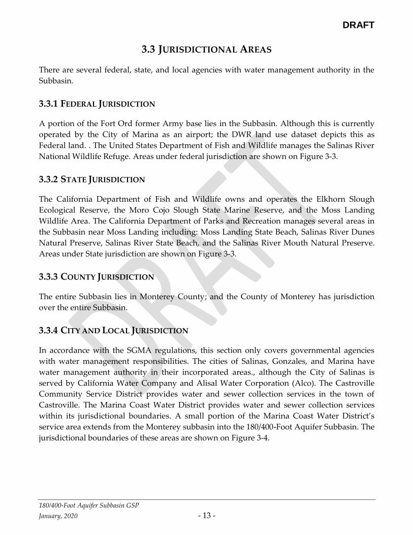
3.3 JURISDICTIONAL AREAS
There are several federal, state, and local agencies with water management authority in the
Subbasin.
3.3.1 FEDERAL JURISDICTION
A portion of the Fort Ord former Army base lies in the Subbasin. Although this is currently
operated by the City of Marina as an airport; the DWR land use dataset depicts this as
Federal land. . The United States Department of Fish and Wildlife manages the Salinas River
National Wildlife Refuge. Areas under federal jurisdiction are shown on Figure 3-3.
3.3.2 STATE JURISDICTION
The California Department of Fish and Wildlife owns and operates the Elkhorn Slough
Ecological Reserve, the Moro Cojo Slough State Marine Reserve, and the Moss Landing
Wildlife Area. The California Department of Parks and Recreation manages several areas in
the Subbasin near Moss Landing including: Moss Landing State Beach, Salinas River Dunes
Natural Preserve, Salinas River State Beach, and the Salinas River Mouth Natural Preserve.
Areas under State jurisdiction are shown on Figure 3-3.
3.3.3 COUNTY JURISDICTION
The entire Subbasin lies in Monterey County; and the County of Monterey has jurisdiction
over the entire Subbasin.
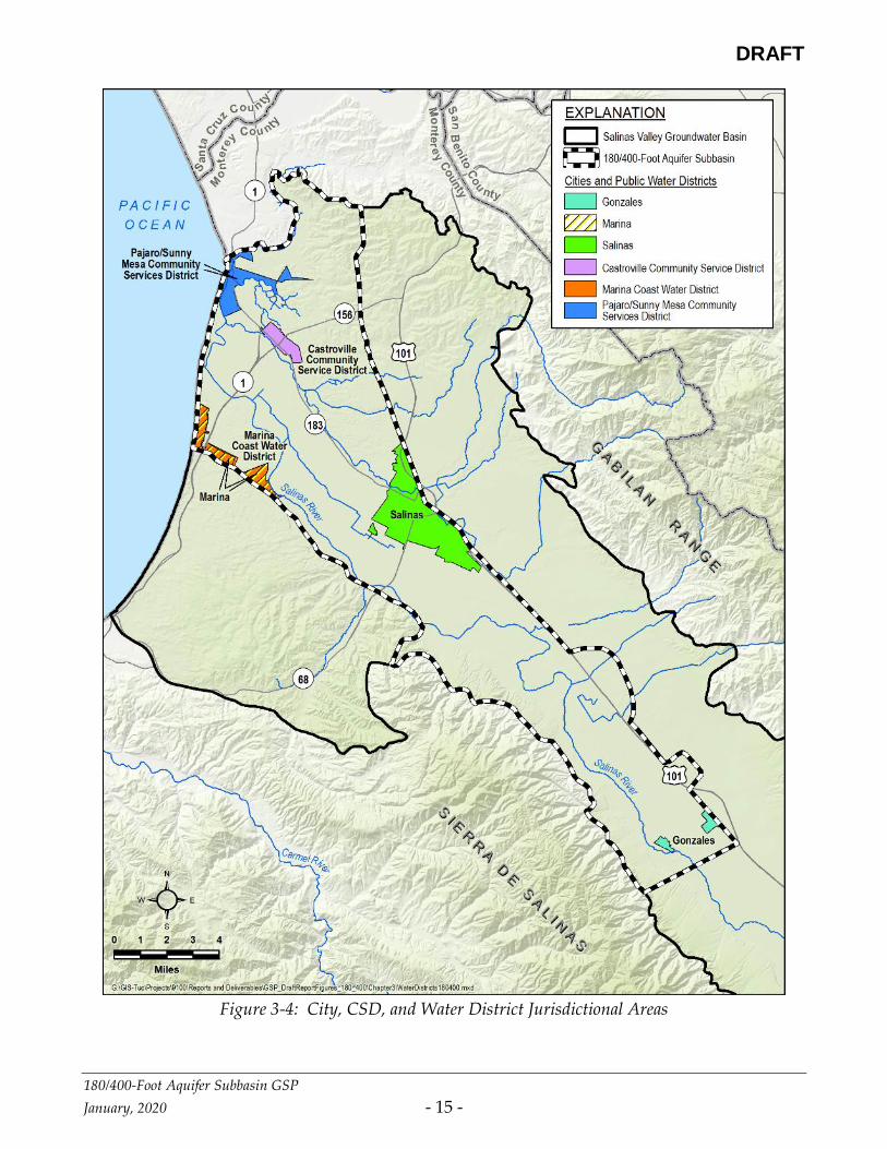
3.3.4 CITY AND LOCAL JURISDICTION
In accordance with the SGMA regulations, this section only covers governmental agencies
with water management responsibilities. The cities of Salinas, Gonzales, and Marina have
water management authority in their incorporated areas., although the City of Salinas is
served by California Water Company and Alisal Water Corporation (Alco). The Castroville
Community Service District provides water and sewer collection services in the town of
Castroville. The Marina Coast Water District provides water and sewer collection services
within its jurisdictional boundaries. A small portion of the Marina Coast Water District’s
service area extends from the Monterey subbasin into the 180/400-Foot Aquifer Subbasin. The
jurisdictional boundaries of these areas are shown on Figure 3-4.

DRAFT
180/400-Foot Aquifer Subbasin GSP
January, 2020 - 14 -
Figure 3-3: Map of Federal and State Groundwater Jurisdictional Areas
DRAFT
180/400-Foot Aquifer Subbasin GSP
January, 2020 - 15 -
Figure 3-4: City, CSD, and Water District Jurisdictional Areas

DRAFT
180/400-Foot Aquifer Subbasin GSP
January, 2020 - 16 -
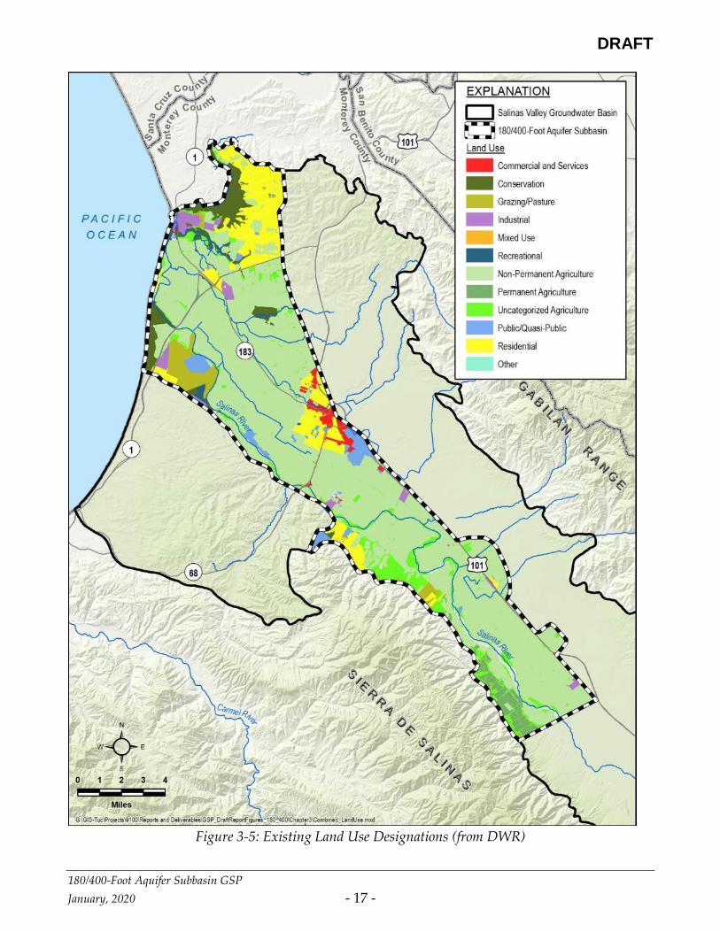
3.4 LAND USE
Land use planning authority in the 180/400-Foot Aquifer Subbasin is the responsibility of the
County of Monterey and the cities of Salinas and Gonzales. Land use information for the
Subbasin was obtained from the California Department of Water Resources Statewide 2014
Crop Mapping Study conducted by LandIQ (DWR, 2017). Current land use in the Subbasin
is shown on Figure 3-5 and summarized by major category in Table 3-1 (DWR, 2014).
The majority of land in the Subbasin is used for agriculture; the top three crops, by value, in
Monterey County in 2017 were lettuce, strawberries, and broccoli (Monterey County
Agriculture Commissioner, 2018. Vineyards are also a major crop in Monterey County.
Table 3-1: Land use summary
Category Area in subbasin (acres)
Permanent Agriculture 1,690
Non-Permanent Agriculture 51,527
Non-categorized Agriculture 11,373
Commercial and Services 1,167
Residential 9,896
Industrial 1,602
Mixed Use 145
Public/Quasi-Public 2,470
Pasture and Grazing 2,348
Conservation 4,536
Recreation 448
Other 2,494
Total 89,696
Source: CADWR, 2017
https://gis.water.ca.gov/app/CADWRLandUseViewer
DRAFT
180/400-Foot Aquifer Subbasin GSP
January, 2020 - 17 -
Figure 3-5: Existing Land Use Designations (from DWR)

DRAFT
180/400-Foot Aquifer Subbasin GSP
January, 2020 - 18 -
3.4.1 WATER SOURCE TYPES
The Subbasin has three water source types: groundwater, surface water, and recycled water.
Groundwater is the primary water source for all water use sectors in the Subbasin. Municipal
areas that depend on groundwater are shown in green on Figure 3-6. Groundwater is also
used for rural residential areas, small community systems, and small commercial operations
such as vineyards, golf courses, and schools.
The coastal farmland surrounding Castroville receives a combination of recycled water from
SVBGSA member Monterey One Water, groundwater, and surface water from the Castroville
Seawater Intrusion Project (CSIP). CSIP delivers this water to the agricultural land indicated
on Figure 3-6 (Brown and Caldwell, 2015). Reclaimed water is additionally used for
irrigation in the Las Palmas Ranch development.
Surface water is supplied from the Salinas River and its tributaries. Direct diversions provide
surface water to agriculture, and additional surface water is diverted through a pneumatic
diversion dam known as the Salinas River Diversion Facility (SRDF). This dam is located on
the Salinas River near Marina. The SRDF provides surface water to the CSIP distribution
system to offset groundwater pumping.

DRAFT
180/400-Foot Aquifer Subbasin GSP
January, 2020 - 19 -
Figure 3-6: Municipal Areas Dependent on Groundwater and the CSIP Distribution Area

DRAFT
180/400-Foot Aquifer Subbasin GSP
January, 2020 - 20 -
3.4.2 WATER USE SECTORS
Groundwater demands in the Subbasin are organized into the six water use sectors identified
in the GSP emergency regulations. Groundwater extraction data are reported by MCWRA
for areas within Zones 2, 2A, and 2B. This area is slightly larger than the 180/400-Foot Aquifer
subbasin described in this GSP, and therefore the demand numbers reported by MCWRA
cover the entire Subbasin. Groundwater demand categories include:
• Urban. Urban water use is assigned to non-agricultural water uses in the cities and
census-designated places. Domestic use outside of census-designated places is not
considered urban use. For the years 2010-2015, urban water use averaged 17,400 ac-ft
and accounted for an average of 15% of the groundwater pumped in the Subbasin
(MCWRA, 2016).
• Industrial. There is limited industrial use in the Subbasin. DWR does not have any
records of wells in the subbasin that are categorized as for industrial use. MCWRA
records lump Industrial use and Urban use together as a single type of water use.
• Agricultural. This is the largest water use sector in the Subbasin; with an annual
average use of 96,600 ac-ft between 2010 and 2015 (MCWRA, 2016). Agricultural water
use accounted for an average of 85% of the groundwater pumped in the Subbasin
(MCWRA, 2016).
• Managed wetlands. DWR land use records indicate that there is one managed
wetland in the Subbasin; an 11.2-acre wetland owned by the State of California and
located northeast of the Monte De Lago neighborhood, between state highway 156 and
Castroville Boulevard.
• Managed recharge. There is no managed recharge in the Subbasin. Wastewater
treated by the Salinas Valley Reclamation Project (SVRP) is distributed by the CSIP
distribution system and used to offset agricultural groundwater pumping within the
CSIP service area.
• Native vegetation. Approximately 90% of the Subbasin is composed of commercial,
industrial, agricultural, or residential land uses. Approximately 4% is identified as
“conservation” and approximately 5% is identified as “public” or “quasi-public”.
Groundwater use by native vegetation is minimal. Although not a native species,
water use by Arundo donax is estimated at between 32,000 and 64,000 AFY in the entire
Salinas Valley (California Invasive Plan Council, 2011); an unknown quantity occurs
within the 180/400-Foot Aquifer subbasin.

DRAFT
180/400-Foot Aquifer Subbasin GSP
January, 2020 - 21 -
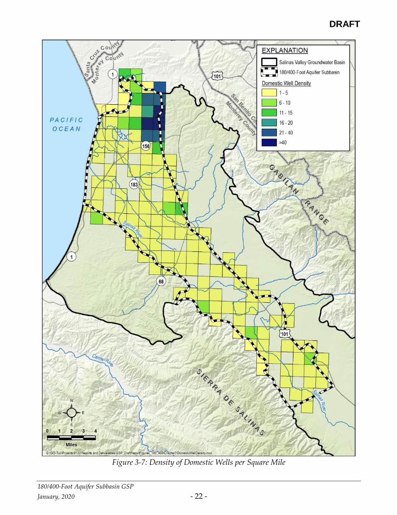
3.5 EXISTING WELL TYPES, NUMBERS, AND DENSITY
Well density data for this GSP were derived from the database of wells that DWR specifically
developed for use in GSPs. Other data sources are available from MCWRA or other sources;
and they may have different data. The DWR data were used for simplicity and consistency
with other DWR data used in this GSP.
DWR’s Well Completion Report Map Application classifies wells as domestic, production,
and municipal; the majority of production wells are assumed to be used for agricultural
irrigation, with some production wells used for industrial purposes. More than half of the
wells in the DWR dataset are production wells. Domestic wells account for most of the
remaining wells. Some of the domestic wells identified by DWR may be classified as de
minimis extractors, defined as pumping less than 2 Acre-Feet per year (AFY). Well counts in
the Subbasin are summarized in Table 3-2. Figure 3-7 and Figure 3-8 show the density of
domestic and agricultural production wells, respectively, per square mile in the Subbasin.
Fewer than 3% of wells in the Subbasin are classified as public supply wells; even though
groundwater is the primary water source for urban and rural communities in the Subbasin.
Figure 3-9 shows the density of municipal wells per square mile. Figure 3-6 identifies
municipal areas dependent upon groundwater.
Table 3-2: Well count summary
Category Number of wells
Domestic 691
Production 780
Public Supply 43
Total 1514
DRAFT
180/400-Foot Aquifer Subbasin GSP
January, 2020 - 22 -
Figure 3-7: Density of Domestic Wells per Square Mile

DRAFT
180/400-Foot Aquifer Subbasin GSP
January, 2020 - 23 -
Figure 3-8: Density of Agricultural Production Wells per Square Mile

DRAFT
180/400-Foot Aquifer Subbasin GSP
January, 2020 - 24 -
Figure 3-9 Density of Municipal Wells per Square Mile
DRAFT
180/400-Foot Aquifer Subbasin GSP
January, 2020 - 25 -
3.6 EXISTING MONITORING PROGRAMS
3.6.1 EXISTING GROUNDWATER LEVEL MONITORING
3.6.1.1 MCWRA MONTHLY GROUNDWATER LEVEL MONITORING
MCWRA collects monthly groundwater level measurement from approximately 100 wells
throughout the Salinas Valley. Of these wells, 38 are in the 180/400-Foot Aquifer Subbasin.
MCWRA processes these monthly measurements to develop a computed average of depth to
water for each Subbasin.
3.6.1.2 MCWRA ANNUAL FALL GROUNDWATER LEVEL MONITORING
Each fall, MCWRA collects annual groundwater level measurements from an additional 120
wells in the 180/400-Foot Aquifer Subbasin. MCWRA uses these annual measurements to
develop contour maps depicting the groundwater table elevation.
3.6.1.3 MCWRA AUGUST GROUNDWATER LEVEL MONITORING
MCWRA collects groundwater level measurements every August from approximately 100
wells in the 180/400-Foot Aquifer Subbasin to establish the location and extent of
groundwater pumping depressions that drive seawater intrusion. The August
measurements usually coincides with the end of the irrigation season, and groundwater
levels at this time reflect low groundwater elevations prior to the onset of seasonal winter
recharge. These pumping depressions occur in the Pressure 180-Foot and Pressure 400-Foot
Aquifers between the City of Salinas and the coast. MCWRA uses the August groundwater
elevation data to develop groundwater contour maps of the coastal pumping depressions on
odd-numbered years.
3.6.1.4 CALIFORNIA STATEWIDE GROUNDWATER ELEVATION MONITORING (CASGEM)
MCWRA is the responsible agency for CASGEM monitoring in Monterey County. The
monitoring network comprises 51wells throughout the Salinas Valley. Of these 51 wells, 23
are in the 180/400-Foot Aquifer Subbasin. Some of the CASGEM monitoring wells are owned
by MCWRA and others are privately owned by owners who have volunteered the well for
inclusion in the CASGEM program. MCWRA collects quarterly groundwater elevation data
from the CASGM wells and reports the groundwater elevation data to DWR twice per year.
Figure 3-10 shows the locations of the CASGEM monitoring wells in the 180/400-Foot Aquifer
Subbasin.

DRAFT
180/400-Foot Aquifer Subbasin GSP
January, 2020 - 26 -
Figure 3-10: Locations of CASGEM Wells in the 180/400-Foot Aquifer Subbasin

DRAFT
180/400-Foot Aquifer Subbasin GSP
January, 2020 - 27 -
3.6.2 GROUNDWATER EXTRACTION MONITORING
MCWRA collects groundwater extraction information from all wells in the 180/400-Foot
Aquifer Subbasin that have discharge pipes of three inches or greater in diameter. These data
have been collected since 1993. Extraction is self-reported by well owners.
3.6.3 GROUNDWATER QUALITY MONITORING
3.6.3.1 MCWRA SEAWATER INTRUSION MONITORING
MCWRA monitors seawater intrusion in the Salinas Valley with a network of 121 monitoring
wells located in the 180/400-Foot Aquifer Subbasin. 96 wells in the network are agricultural
production wells that are sampled annually in June and August (during peak pumping). 25
wells in the network are dedicated monitoring wells that are maintained by either MCWRA
or by California-American Water as part of its Monterey Peninsula Water Supply Project
(MPWSP).
Water quality samples from the wells are analyzed for major constituents, including anions
and cations, conductivity, etc. The data are used to develop time-series plots of chloride and
conductivity trends, Stiff and Piper diagrams, and to compute molar ratios of chloride to
sodium.
The data are used to prepare maps of seawater intrusion in the 180/400-Foot Aquifer in odd-
numbered years. Additional information about the occurrence and extent of seawater
intrusion in both the 180- and 400-Foot Aquifers is provided in Section 5.
3.6.3.2 OTHER
Groundwater quality is monitored under several different programs and by different
agencies including:
• Muncipal and community water purveyors must collect water quality samples on a
routine basis for compliance monitoring and reporting to the California Division of
Drinking Water.
• The USGS collects water quality data on a routine basis under the Groundwater
Ambient Monitoring and Assessment (GAMA) program. These data are stored in the
State’s GAMA/Geotracker system. Figure 3-11 shows the location of wells in the
State’s GAMA Geotracker database that are in the 180/400-Foot Aquifer subbasin.

DRAFT
180/400-Foot Aquifer Subbasin GSP
January, 2020 - 28 -
• There are multiple sites that are monitoring groundwater quality as part of
investigation or compliance monitoring programs through the Central Coast Regional
Water Quality Control Board.
• Required California American (CalAm) Water Company and MCWRA monitoring
wells for CalAm’s proposed source wells for the MPWSP.
3.6.4 SURFACE WATER MONITORING
Streamflow gages operated by the USGS within the 180/400-Foot Aquifer Subbasin include:
• Reclamation Ditch near Salinas (USGS Site #11152650)
• Salinas River near Chualar (USGS Site #11152300)
• Salinas River near Spreckels (USGS Site #11152500)
Water levels (stage) in the Salinas River Lagoon are measured by MCWRA at Monte Road
and near the slide gate to the Old Salinas River. The locations of the surface-water
monitoring facilities are depicted in Figure 3-12.

DRAFT
180/400-Foot Aquifer Subbasin GSP
January, 2020 - 29 -
Figure 3-11: Locations of USGS GAMA Wells in the 180/400-Foot Aquifer Subbasin

DRAFT
180/400-Foot Aquifer Subbasin GSP
January, 2020 - 30 -
Figure 3-12: Surface Water Gaging Locations
DRAFT
180/400-Foot Aquifer Subbasin GSP
January, 2020 - 31 -
3.6.5 INCORPORATING EXISTING MONITORING PROGRAMS INTO THE GSP
The existing monitoring programs and monitoring networks constitute a well-developed and
broadly distributed system that provides representative data throughout the Subbasin. The
groundwater elevation monitoring programs are operated by an existing member of the
SVBGSA, and therefore will be incorporated into the GSP monitoring plan. The existing
groundwater level monitoring programs will be updated and improved to document the
avoidance of undesirable results in each significant aquifer in the Subbasin.
The current water quality monitoring program from the production wells will be
incorporated into this GSP to demonstrate that groundwater quality undesirable results do
not occur based on data from a representative number of production wells. The existing
stream gauges will also be incorporated into this GSP monitoring plan to validate projections
of surface water depletions from pumping.
This section to be completed after GSP is complete.
3.6.6 LIMITS TO OPERATIONAL FLEXIBILITY
The existing monitoring programs are not anticipated to limit the operational flexibility of
this GSP.
3.7 EXISTING MANAGEMENT PLANS
3.7.1 MONTEREY COUNTY GROUNDWATER MANAGEMENT PLAN
MCWRA developed a Groundwater Management Plan (GMP) that is compliant with AB3030
and SB1938 legislation (MCWRA, 2006). This GMP exclusively covered the Salinas Valley in
Monterey County.
The GMP identified three objectives for groundwater management:
Objective 1: Development of Integrated Water Supplies to Meet Existing and Projected
Water Requirements
Objective 2: Determination of Sustainable Yield and Avoidance of Overdraft
Objective 3: Preservation of Groundwater Quality for Beneficial Use
To meet these three objectives, the plan identified 14 elements that should be implemented
by MCWRA:

DRAFT
180/400-Foot Aquifer Subbasin GSP
January, 2020 - 32 -
Plan Element 1: Monitoring of Groundwater Levels, Quality, Production, and Subsidence
Plan Element 2: Monitoring of Surface Water Storage, Flow, and Quality
Plan Element 3: Determination of Basin Yield and Avoidance of Overdraft
Plan Element 4: Development of Regular and Dry Year Water Supply
Plan Element 5: Continuation of Conjunctive Use Operations
Plan Element 6: Short-Term and Long-Term Water Quality Management
Plan Element 7: Continued Integration of Recycled Water
Plan Element 8: Identification and Mitigation of Groundwater Contamination
Plan Element 9: Identification and Management of Recharge Areas and Wellhead
Protection Areas
Plan Element 10: Identification of Well Construction, Abandonment, and Destruction
Policies
Plan Element 11: Continuation of Local, State and Federal Agency Relationships
Plan Element 12: Continuation of Public Education and Water Conservation Programs
Plan Element 13: Groundwater Management Reports
Plan Element 14: Provisions to Update the Groundwater Management Plan
3.7.2 INTEGRATED REGIONAL WATER MANAGEMENT PLAN
The Greater Monterey County Integrated Regional Water Management (IRWM) Plan was
developed by the Greater Monterey County Regional Water Management Group (RWMG),
which consists of government agencies, nonprofit organizations, educational organizations,
water service districts, private water companies, and organizations representing agricultural,
environmental, and community interests, including:
• Big Sur Land Trust
• California State University Monterey Bay
• California Water Service Company
• Castroville Community Services District
• City of Salinas
• City of Soledad
• Elkhorn Slough National Estuarine Research Reserve
• Environmental Justice Coalition for Water
• Garrapata Creek Watershed Council
• Marina Coast Water District
• Monterey Bay National Marine Sanctuary
• Monterey County Agricultural Commissioner’s Office
• Monterey County Water Resources Agency
• Monterey Regional Water Pollution Control Agency
DRAFT
180/400-Foot Aquifer Subbasin GSP
January, 2020 - 33 -
• Moss Landing Marine Laboratories
• Resource Conservation District of Monterey County
• Rural Community Assistance Corporation
• San Jerardo Cooperative, Inc
The 180/400-Foot Aquifer subbasin falls within f the IRWM Plan area The IRWM Plan
consists of a set of goals and objectives that were identified by the RWMG as being critical to
address water resource issues within the planning area in the areas of:
• Water Supply
• Water Quality
• Flood Protection and Floodplain Management
• Environment
• Regional Communication and Cooperation
• Disadvantaged Communities
• Climate Change
The IRWM Plan includes more than 25 projects that could assist regional groundwater
management.
DRAFT
180/400-Foot Aquifer Subbasin GSP
January, 2020 - 34 -
3.7.3 URBAN WATER MANAGEMENT PLANS
3.7.3.1 CALIFORNIA WATER SERVICE (SALINAS DISTRICT) URBAN WATER MANAGEMENT PLAN
California Water Service serves a portion of the City of Salinas. Its 2015 Urban Water
Management Plan (UWMP) (CA Water Service, 2016) describes the service area; reports
historic and projected population; identifies historic and projected water demand by category
(single-family, multi-family, commercial, industrial, institutional/government, and other);
and describes the distribution system and identifies losses.
The UWMP describes the system’s reliance on groundwater and California Water Service’s
support for efforts to avoid overdraft, including working cooperatively with MCWRA and
participation in the development of this GSP. Specific activities that California Water Service
intends to conduct include:
• Outreach to public agencies to ensure that the Company’s presence, rights and
interests, as well as historical and current resource management concerns are
honored/incorporated within the GSA and GSP formulation process(es).
• Outreach to applicable local and regulatory agencies to ensure that the Company’s full
participation, while also meeting the requirements and expectations set forth by
SGMA.
• The enhanced use of digital/electronic groundwater monitoring equipment and other
new technology aimed at measuring withdrawal rates, pumping water levels, and key
water quality parameters within the context of day-to-day operations.
• Full participation in the development of GSP's and formulation of groundwater
models being constructed in basins where the Company has an operating presence.
• Full participation in individual and/or joint projects aimed at mitigating seawater
intrusion and other undesirable results.
• Inclusion of sound groundwater management principles and data in all applicable
technical reports, studies, facility master plans, and urban water management plans
(including this 2015 update), particularly as these undertakings relate or pertain to
water resource adequacy and reliability.
• Inclusion of sound groundwater management principles and data in all general rate
case (GRC) filings and grant applications to ensure that resource management
objectives remain visible and central to Cal Water’s long-term planning/budgeting
efforts.
The UMWP also addresses California Water Service’s position on alternative supplies
currently being developed for the Salinas Valley. California Water Service is evaluating the
DRAFT
180/400-Foot Aquifer Subbasin GSP
January, 2020 - 35 -
possibility of using up to 10,000 AFY (or more) of water from the proposed Deep Water Desal
LLC desalination plant at Moss Landing.
The UWMP addresses the need for California Water Service to implement a well replacement
program to mitigate water quality impacts from nitrates, uranium, MTBE, and sand
contamination.
California Water Service’s UWMP notes that it is expected that groundwater will continue to
remain as its sole supply source due to uncertainties regarding the cost and implementation
other options, such as surface water diversion or desalination. However, the UWMP
recognizes that it would be beneficial for California Water Service to diversify its supply
portfolio.
California Water Service evaluated the impact of climate change on its water supply. The
study found that climate change could result in a supply reduction of 6% to 7% by the end of
the century.
3.7.3.2 CALIFORNIA AMERICAN WATER COMPANY (CHUALAR)
The California American (Cal-Am) Water Company operates a satellite water system serving
approximately 1,000 residents near Chualar. The operation of this system is described in Cal-
Am’s 2010 UWMP. The Cal-Am UWMP provides a description of the system, historic and
projected water demands, and an assessment of current and future water supplies. Although
the Cal-Am UWMP discusses future water supply options such as desalination, aquifer
storage and recovery, and recycled water; none of these are applicable to the Chualar satellite
system.
The Chualar system is entirely dependent on groundwater from the 180-Foot Aquifer, and is
far enough inland that it is not considered susceptible to seawater intrusion. The UWMP
reports that water quality from the Chualar system wells is generally good.
3.7.3.3 MARINA COAST WATER DISTRICT URBAN WATER MANAGEMENT PLAN
The MCWD most recently updated its UWMP in 2015 (Schaff & Wheeler, 2016). The UWMP
describes the service area; reports historic and projected population; identifies historic and
projected water demand by category (single-family, multi-family, commercial, industrial,
institutional/government, and other); and describes the distribution system and identifies
losses.
The MCWD currently relies solely on groundwater, although the UWMP notes that, “The
District is located along the Salinas River, and MCWD Board of Directors has considered
DRAFT
180/400-Foot Aquifer Subbasin GSP
January, 2020 - 36 -
purchasing surface water rights in the Salinas River Basin as a means of meeting long-term
(beyond 2030) demands.” The UWMP further notes that, “…the total Ord Community
groundwater supply of 6,600 afy falls short of the total 2030 Ord Community demand of
8,293 afy by 1,693 afy. [and] …the Central Marina service area is not projected to exceed its
current SVGB groundwater allocation from the Fort Ord Reuse Authority (FORA) within the
planning period.”
The MCWD UWMP includes a number of demand management measures including:
• Water Waste Prevention Ordinances
• Metering
• Conservation Pricing
• Public Education and Outreach
• Programs to Assess and Manage Distribution System Real Loss
• Water Conservation Program Coordination and Staffing Support
• Water Survey Programs for Residential Customers
• Residential Plumbing Retrofits
• Residential Ultra-Low Flow Toilet Replacement Programs
• High-Efficiency Washing Machine Rebate Programs
• Commercial, Industrial, and Institutional Accounts
• Landscape Conservation Programs and Incentives
3.8 EXISTING GROUNDWATER REGULATORY PROGRAMS
3.8.1 GROUNDWATER EXPORT PROHIBITION
The Monterey County Water Resources Agency Act, § 52.21 prohibits the export of
groundwater from any part of the Salinas Valley Groundwater Basin, including the 180/400-
Foot Aquifer Subbasin. In particular, the Act states:
For the purpose of preserving [the balance between extraction and recharge], no
groundwater from that basin may be exported for any use outside the basin, except that
use of water from the basin on any part of Fort Ord shall not be deemed such an export. If
any export of water from the basin is attempted, the Agency may obtain from the superior
court, and the court shall grant, injunctive relief prohibiting that exportation of
groundwater.

DRAFT
180/400-Foot Aquifer Subbasin GSP
January, 2020 - 37 -
3.8.2 AGRICULTURAL ORDER
In 2017 the Central Coast Regional Water Quality Control Board (CCRWQCB) issued
Agricultural Order No. R3-2017-0002, a Conditional Waiver of Waste Discharge
Requirements for Discharges from Irrigated Lands (Agricultural Order). The permit requires
that growers implement practices to reduce nitrate leaching into groundwater and improve
surface receiving water quality. Specific requirements for individual growers are structured
into three tiers based on the relative risk their operations pose to water quality.
Growers must enroll, pay fees, and meet various monitoring and reporting requirements
according to the tier to which they are assigned. All growers are required to implement
groundwater monitoring, either individually or as part of a cooperative regional monitoring
program. Growers electing to implement individual monitoring (i.e., not participating in the
regional monitoring program implemented by the Central Coast Groundwater Coalition or
CCGC) are required to test all on-farm domestic wells and the primary irrigation supply well
for nitrate or nitrate plus nitrite, and general minerals (including, but not limited to, TDS,
sodium, chloride and sulfate).
Negotiations with the Central Coast Regional Water Quality Control Board staff and Board
Members for the next iteration of the Agricultural Order are on-going, expected to conclude
in March 2020 with the adoption of a new Irrigated Lands Regulatory Program (ILRP) Waste
Discharge Requirements (WDR) for farming operations in the Salinas Valley Groundwater
Basin area (and the entire Central Coast region). As mandated by the State Water Resources
Control Board, specific reporting requirements for nitrogen applications and removal,
irrigation and surface water discharge management, and groundwater quality monitoring
will be included with quantifiable milestones. While the outcome is not certain, the
expectation is that the next Agricultural Order will be more complex with additional
compliance reporting measures for all growers.
3.8.3 WATER QUALITY CONTROL PLAN FOR THE CENTRAL COAST BASINS
The Water Quality Control Plan for the Central Coastal Basin (Basin Plan) was most recently
updated in September 2017. The objective of the Basin Plan is to outline how the quality of
the surface water and groundwater in the Central Coast Region should be managed to
provide the highest water quality reasonably possible.
The Basin Plan lists benceficial users, describes the water quality which must be maintained
to allow those uses, provides an implementation plan, details State Water Resources Control
Board (SWRCB) and CCRWQCB plans and polices to protect water quality and a statewide
survelliance and monitoring program as well as regional surveillance and monitoring

DRAFT
180/400-Foot Aquifer Subbasin GSP
January, 2020 - 38 -
programs. The SWRCB’s Sources of Drinking Water Policy adopted in Resolution No. 88-63
and incorporated in its entirety in the CCRWQCB’s Basin Plan provides that water with
water quality equal to or less than 3,000 mg/L TDS is considered suitable or potentially
suitable for drinking water beneficial uses.
Present and potential future beneficial uses for inland waters in the Basin are: surface water
and groundwater as municipal supply (water for community, military or individual water
supplies); agricultural; groundwater recharge; recreational water contact and non-contact;
sport fishing; warm fresh water habitat; wildlife habitat; rare, threatened or endangered
species; and, spawning, reproduction, and/or early development of fish.
Water Quality Objectives for both groundwater (drinking water and irrigation) and surface
water are provided in the Basin Plan.
3.8.4 REQUIREMENTS FOR NEW WELLS
In October, 2017, Governor Brown signed Senate Bill (SB) 252 which became effective on
January 1, 2018. SB 252 requires well permit applicants in critically overdrafted basins to
include information about the proposed well, such as location, depth, and pumping capacity.
The bill also requires the permitting agency to make the information easily accessible to the
public and the GSAs.
3.8.5 TITLE 22 DRINKING WATER PROGRAM
The SWRCB Division of Drinking Water (DDW) regulates public water systems in the State
to ensure the delivery of safe drinking water to the public. A public water system is defined
as a system for the provision of water for human consumption through pipes or other
constructed conveyances that has 15 or more service connections or regularly serves at least
25 individuals daily at least 60 days out of the year. Private domestic wells, wells associated
with drinking water systems with less than 15 residential service connections, industrial and
irrigation wells are not regulated by the DDW.
The DDW enforces the monitoring requirements established in Title 22 of the California Code
of Regulations (CCR) for public water system wells, and all the data collected must be
reported to the DDW. Title 22 also designates the Maximum Contaminant Levels (MCLs) for
various waterborne contaminants, including volatile organic compounds, non-volatile
synthetic organic compounds, inorganic chemicals, radionuclides, disinfection byproducts,
general physical constituents, and other parameters.

DRAFT
180/400-Foot Aquifer Subbasin GSP
January, 2020 - 39 -
3.8.6 INCORPORATING REGULATORY PROGRAMS INTO THE GSP
Information in these various plans have been incorporated into this GSP and used during the
preparation of Sustainability Goals, when setting Minimum Thresholds and Measurable
Objectives and were considered during development of Projects and Management Actions.
This section to be completed after GSP is complete.
3.8.7 LIMITS TO OPERATIONAL FLEXIBILITY
Some of the existing management plans and ordinances will limit operational flexibility.
These limits to operational flexibility have already been incorporated into the sustainability
projects and programs included in this GSP. Examples of limits on operational flexibility
include:
• The groundwater export prohibition included in the Monterey County Water
Resources Agency Act prevents export of water out of the Subbasin. This prohibition
is not expected to adversely affect our ability to reach sustainability.
• The Basin Plan and the Title 22 Drinking Water Program restrict the quality of water
that can be recharged into the Subbasin.
This section to be completed after GSP is complete.
3.9 CONJUNCTIVE USE PROGRAMS
3.9.1 MONTEREY COUNTY WATER RECYCLING PROJECTS
One conjunctive use project operates in the 180/400-Foot Aquifer Subbasin. This project uses
recycled water from the Salinas Valley Reclamation Project and distributes it through the
CSIP distribution system. This project serves approximately 12,000 acres of farmland within
the Subbasin. The extent of the current CSIP distribution area is shown in Figure 3-6. The
recycled water in the CSIP is supplemented with groundwater and surface water diverted
from the SRDF. When river water is available and the SRDF is operating, grower
groundwater pumping has been reduced by about 80% during peak irrigation demand
periods. However, currently, it is necessary to conjunctively manage all three water sources
to match irrigation demands with water supplies.

DRAFT
180/400-Foot Aquifer Subbasin GSP
January, 2020 - 40 -
3.9.2 REGIONAL URBAN WATER AUGMENTATION PROJECT
MCWD is currently installing pipelines for the Regional Urban Water Augmentation Project
(RUWAP). This project includes a recycled water transmission and distribution system that
will provide up to 1,427 ac-ft per year of recycled water to offset groundwater pumping in
the Monterey Subbasin. The initial phase of the project will deliver 600 ac-ft per year of water
to customers in Marina and Fort Ord.
3.10 LAND USE PLANS
Monterey County and the cities of Gonzales, Marina, and Salinas have land use authority
over all or portions of the 180/400-Foot Aquifer Subbasin. Land use is an important factor in
water management as described below. The following sections provide a general description
of these land use plans and how implementation may affect groundwater in the 180/400-ft
Subbasin. The following descriptions were taken from publicly-available general plans at the
time of the GSP preparation.
3.10.1 MONTEREY COUNTY GENERAL PLAN
Relevant elements of the Monterey County General Plan (Monterey County, 2010) are
summarized in Table 3-3.
Table 3-3 Monterey County General Plan Summary
Element Goal / Policy
Land Use LU-1.4 Growth areas shall be designated only where an adequate level
of services and facilities such as water, sewerage, fire and police
protection, transportation, and schools exist or can be assured
concurrent with growth and development. Phasing of
development shall be required as necessary in growth areas in
order to provide a basis for long-range services and facilities
planning
Open Space OS-3.8 The County shall cooperate with appropriate regional, state and
federal agencies to provide public education/outreach and
technical assistance programs on erosion and sediment control,
efficient water use, water conservation and re-use, and
groundwater management. This cooperative effort shall be
centered through the Monterey County Water Resources
Agency.
et. seq.
Public
Services
GOAL PS-2 Assure an adequate and safe water supply to meet the county’s
current and long-term needs. PS-2.1 Coordination among, and consolidation with, those public water
service providers drawing from a common water table to prevent
overdrawing the water table is encouraged.

DRAFT
180/400-Foot Aquifer Subbasin GSP
January, 2020 - 41 -
Element Goal / Policy PS-2.2 The County of Monterey shall assure adequate monitoring of
wells in those areas experiencing rapid growth provided
adequate funding mechanisms for monitoring are established in
the CIFP. PS-2.3 New development shall be required to connect to existing water
service providers where feasible. Connection to public utilities is
preferable to other providers. PS-2.4 Regulations for installing any new domestic well located in
consolidated materials (e.g., hard rock areas) shall be enacted by
the County.
PS-2.5 Regulations shall be developed for water quality testing for new
individual domestic wells on a single lot of record to identify:
a. Water quality testing parameters for a one-time required water
quality test for individual wells at the time of well construction.
b. A process that allows the required one-time water quality test
results to be available to future owners of the well.
Regulations pursuant to this policy shall not establish criteria
that will prevent the use of the well in the development of the
property. Agricultural wells shall be exempt from the regulation.
GOAL PS-3 Ensure that new development is assured a long-term sustainable
water supply.
PS-3.1 Except as specifically set forth below, new development
for which a discretionary permit is required, and that will
use or require the use of water, shall be prohibited
without proof, based on specific findings and supported
by evidence, that there is a long-term, sustainable water
supply, both in quality and quantity to serve the
development….
PS-3.2 Specific criteria for proof of a Long-Term Sustainable
Water Supply and an Adequate Water Supply System for
new development requiring a discretionary permit,
including but not limited to residential or commercial
subdivisions, shall be developed by ordinance with the
advice of the General Manager of the Water Resources
Agency and the Director of the Environmental Health
Bureau. A determination of a Long-Term Sustainable
Water Supply shall be made upon the advice of the
General Manager of the Water Resources Agency. The
following factors shall be used in developing the criteria
for proof of a long-term sustainable water supply and an
adequate water supply system: …
PS-3.3 Specific criteria shall be developed by ordinance for use in
DRAFT
180/400-Foot Aquifer Subbasin GSP
January, 2020 - 42 -
Element Goal / Policy
the evaluation and approval of adequacy of all domestic
wells. The following factors shall be used in developing
criteria for both water quality and quantity including, but
not limited to: …. PS-3.4 The County shall request an assessment of impacts on adjacent
wells and instream flows for new high-capacity wells, including
high-capacity urban and agricultural production wells, where
there may be a potential to affect existing adjacent domestic or
water system wells adversely or in-stream flows, as determined
by the Monterey County Water Resources Agency. In the case
of new high-capacity wells for which an assessment shows the
potential for significant adverse well interference, the County
shall require that the proposed well site be relocated or
otherwise mitigated to avoid significant interference. The
following factors shall be used in developing criteria by
ordinance for use in the evaluation and approval of adequacy of
all such high-capacity wells, including but not limited to:
a. Effect on wells in the immediate vicinity as required by the
Monterey County Water Resources Agency or Environmental
Health Bureau.
b. Effects of additional extractions or diversion of water on in-
stream flows necessary to support riparian vegetation, wetlands,
fish, and other aquatic life including migration potential for
steelhead, for the purpose of minimizing impacts to those
resources and species.
This policy is not intended to apply to replacement wells.
PS-3.5 The Monterey County Health Department shall not allow
construction of any new wells in known areas of saltwater
intrusion as identified by Monterey County Water Resources
Agency or other applicable water management agencies:
a. Until such time as a program has been approved and funded
that will minimize or avoid expansion of salt water intrusion
into useable groundwater supplies in that area; or
b. Unless approved by the applicable water resource agency.
This policy shall not apply to deepening or replacement of
existing wells, or wells used in conjunction with a desalination
project.
PS-3.6 The County shall coordinate and collaborate with all agencies
responsible for the management of existing and new water
resources
PS-3.7 A program to eliminate overdraft of water basins shall be
developed as part of the Capital Improvement and Financing
Plan (CIFP) for this Plan using a variety of strategies, which
may include but are not limited to:
a. Water banking;

DRAFT
180/400-Foot Aquifer Subbasin GSP
January, 2020 - 43 -
Element Goal / Policy b. Groundwater and aquifer recharge and recovery;
c. Desalination;
d. Pipelines to new supplies; and/or
e. A variety of conjunctive use techniques.
The CIFP shall be reviewed every five (5) years in order to
evaluate the effectiveness of meeting the strategies noted in this
policy. Areas identified to be at or near overdraft shall be a high
priority for funding.
PS-3.8 Developments that use gray water and cisterns for multi-family
residential and commercial landscaping shall be encouraged,
subject to a discretionary permit.
PS-3.9 A tentative subdivision map and/or vesting tentative subdivision
map application for either a standard or minor subdivision shall
not be approved until the applicant provides evidence of a long-
term sustainable water supply in terms of yield and quality for
all lots that are to be created through subdivision.
PS-3.10 In order to maximize agricultural water conservation measures
to improve water use efficiency and reduce overall water
demand, the County shall establish an ordinance identifying
conservation measures that reduce agricultural water demand.
PS-3.11 In order to maximize urban water conservation measures to
improve water use efficiency and reduce overall water demand,
the County shall establish an ordinance identifying conservation
measures that reduce potable water demand
PS-3.12 The County shall maximize the use of recycled water as a
potable water offset to manage water demands and meet
regulatory requirements for wastewater discharge, by employing
strategies including, but not limited to, the following:
a. Increase the use of treated water where the quality of recycled
water is maintained, meets all applicable regulatory standards, is
appropriate for the intended use, and re-use will not significantly
impact beneficial uses of other water resources.
b. Work with the agricultural community to develop new uses
for tertiary recycled water and increase the use of tertiary
recycled water for irrigation of lands currently being irrigated by
groundwater pumping.
c. Work with urban water providers to emphasize use of tertiary
recycled water for irrigation of parks, playfields, schools, golf
courses, and other landscape areas to reduce potable water
demand.
d. Work with urban water providers to convert existing potable
water customers to tertiary recycled water as infrastructure and
water supply become available.
PS-3.13 To ensure accuracy and consistency in the evaluation of water
supply availability, the Monterey County Health Department, in
coordination with the MCWRA, shall develop guidelines and

DRAFT
180/400-Foot Aquifer Subbasin GSP
January, 2020 - 44 -
Element Goal / Policy procedures for conducting water supply assessments and
determining water availability. Adequate availability and
provision of water supply, treatment, and conveyance facilities
shall be assured to the satisfaction of the County prior to
approval of final subdivision maps or any changes in the
General Plan Land Use or Zoning designations.
PS-3.14 The County will participate in regional coalitions for the
purpose of identifying and supporting a variety of new water
supply projects, water management programs, and multiple
agency agreements that will provide additional domestic
water supplies for the Monterey Peninsula and Seaside basin,
while continuing to protect the Salinas and Pajaro River
groundwater basins from saltwater intrusion. The County will
also participate in regional groups including representatives of
the Pajaro Valley Water Management Agency and the County of
Santa Cruz to identify and support a variety of new water
supply, water management and multiple agency agreement that
will provide additional domestic water supplies for the Pajaro
Groundwater Basin. The County’s general objective, while
recognizing that timeframes will be dependent on the dynamics
of each of the regional groups, will be to complete the
cooperative planning of these water supply alternatives within
five years of the adoption of the General Plan and to implement
the selected alternatives within five (5) years after that time.
PS-3.15 The County will pursue expansion of the Salinas Valley Water
Project (SVWP) by investigating expansion of the capacity for
the Salinas River water storage and distribution system. This
shall also include, but not be limited to, investigations of
expanded conjunctive use, use of recycled water for
groundwater recharge and seawater intrusion barrier, and
changes in operations of the reservoirs. The County’s overall
objective is to have an expansion planned and in service by the
date that the extractions from the Salinas Valley groundwater
basin are predicted to reach the levels estimated for 2030 in the
EIR for the Salinas Valley Water Project. The County shall
review these extraction data trends at five-year intervals. The
County shall also assess the degree to which the Salinas Valley
Groundwater Basin (Zone 2C) has responded with respect to
water supply and the reversal of seawater intrusion based upon
the modeling protocol utilized in the Salinas Valley Water
Project EIR. If the examination indicates that the growth in
extractions predicted for 2030 are likely to be attained within ten
years of the date of the review, or the groundwater basin has not
responded with respect to water supply and reversal of seawater
intrusion as predicted by the model, then the County shall
convene and coordinate a working group made up of the Salinas
DRAFT
180/400-Foot Aquifer Subbasin GSP
January, 2020 - 45 -
Element Goal / Policy Valley cities, the MCWRA, and other affected entities. The
purpose will be to identify new water supply projects, water
management programs, and multiple agency agreements that
will provide additional domestic water supplies for the Salinas
Valley. These may include, but not be limited to, expanded
conjunctive use programs, further improvements to the upriver
reservoirs, additional pipelines to provide more efficient
distribution, and expanded use of recycled water to reinforce the
hydraulic barrier against seawater intrusion. The county’s
objective will be to complete the cooperative planning of these
water supply alternatives within five years and to have the
projects on-line five years following identification of water
supply alternatives.
The Monterey County General Plan does not include population projections; however, the
Association of Monterey Bay Area Governments (AMBAG) has developed population
projections through 2050, as shown in Table 3-4.

DRAFT
180/400-Foot Aquifer Subbasin GSP
January, 2020 - 46 -
Table 3-4: Monterey County Population Projections
3.10.2 CITY OF SALINAS GENERAL PLAN
The Land Use and Conservation/Open Space Elements of the City of Salinas General Plan
(City of Salinas, 2002) are relevant to water-resources within the 180/400-Foot Subbasin,
and are summarized in Table 3-5.
Table 3-5: City of Salinas General Plan Summary
Element Goal / Policy
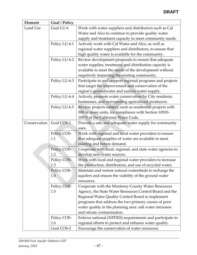
DRAFT
180/400-Foot Aquifer Subbasin GSP
January, 2020 - 47 -
Element Goal / Policy
Land Use Goal LU-6 Work with water suppliers and distributors such as Cal
Water and Alco to continue to provide quality water
supply and treatment capacity to meet community needs.
Policy LU-6.1 Actively work with Cal Water and Alco, as well as
regional water suppliers and distributors, to ensure that
high quality water is available for the community.
Policy LU-6.2 Review development proposals to ensure that adequate
water supplies, treatment, and distribution capacity is
available to meet the needs of the development without
negatively impacting the existing community,
Policy LU-6.3 Participate in and support regional programs and projects
that target the improvement and conservation of the
region’s groundwater and surface water supply.
Policy LU-6.4 Actively promote water conservation by City residents,
businesses, and surrounding agricultural producers.
Policy LU-6.5 Review projects subject, such as residential projects with
500 or more units, for compliance with Section 10910-
10915 of the California Water Code.
Conservation Goal COS-1 Provide a safe and adequate water supply for community
uses.
Policy COS-
1.1
Work with regional and local water providers to ensure
that adequate supplies of water are available to meet
existing and future demand.
Policy COS-
1.2
Cooperate with local, regional, and state water agencies to
develop new water sources.
Policy COS-
1.3
Work with local and regional water providers to increase
the production, distribution, and use of recycled water,
Policy COS-
1.4
Maintain and restore natural watersheds to recharge the
aquifers and ensure the viability of the ground water
resources.
Policy COS-
1.5
Cooperate with the Monterey County Water Resources
Agency, the State Water Resources Control Board and the
Regional Water Quality Control Board to implement
programs that address the two primary causes of poor
water quality in the planning area: salt water intrusion
and nitrate contamination.
Policy COS-
1.6
Enforce national (NPDES) requirements and participate in
regional efforts to protect and enhance water quality.
Goal COS-2 Encourage the conservation of water resources.

DRAFT
180/400-Foot Aquifer Subbasin GSP
January, 2020 - 48 -
Element Goal / Policy
Policy COS-
2.1
Participate in and implement local and regional programs
that promote water conservation.
Policy COS-
2.2
Work with water providers to institute conservation
programs to address water supply problems caused by
groundwater overdrafting,
Policy COS-
2.3
Apply standards that promote water conservation in
agricultural, residential and non-residential uses.
Policy COS-
2.4
Enforce the City’s Water Conservation Ordinance.
3.10.3 CITY OF GONZALES GENERAL PLAN
Relevant elements of the City of Gonzales General Plan (City of Gonzales, 2011) are
summarized Table 3-6.
Table 3-6: City of Gonzales General Plan Summary
Element Goal / Policy
Land Use LU-1.2.2 New developments must have adequate water supplies.
LU-8.3.1: Modify proposed designs for industrial development to
reduce adverse environmental impacts, particularly nose,
air, and water pollution, odor, soil, and groundwater
contamination, traffic, and visual blight to the degree
practicable.
LU-8.3.2 Plan for Sewer and Water Expansion. Ensure that
adequate water and sewer capacity is available to support
all areas designated for industrial development
Housing HE-9.2 Promote Water Conservation Promote the use of water-
saving devices, drought-tolerant landscaping, and other
water conservation measures to achieve a reduction in
home water bills for residential customers
HE-9.4.1 Water Conservation. The City will continue to promote
ways to reduce monthly home water bills. Such measures
already include: (a) requiring new houses to utilize low-
flow toilets, low-flow shower heads, and low flow faucets
consistent with the requirements of the Monterey County
Water Resources Agency, and (b) requiring the use of
drought-tolerant landscaping within new developments
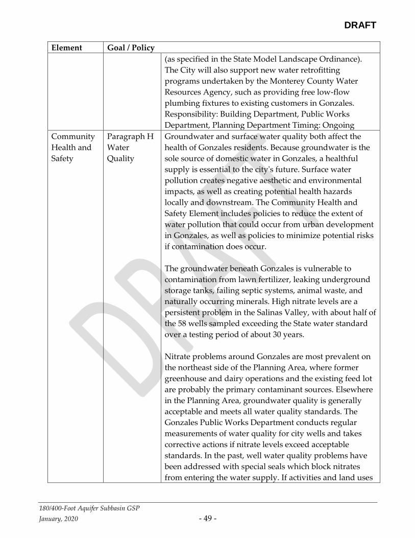
DRAFT
180/400-Foot Aquifer Subbasin GSP
January, 2020 - 49 -
Element Goal / Policy
(as specified in the State Model Landscape Ordinance).
The City will also support new water retrofitting
programs undertaken by the Monterey County Water
Resources Agency, such as providing free low-flow
plumbing fixtures to existing customers in Gonzales.
Responsibility: Building Department, Public Works
Department, Planning Department Timing: Ongoing
Community
Health and
Safety
Paragraph H
Water
Quality
Groundwater and surface water quality both affect the
health of Gonzales residents. Because groundwater is the
sole source of domestic water in Gonzales, a healthful
supply is essential to the city's future. Surface water
pollution creates negative aesthetic and environmental
impacts, as well as creating potential health hazards
locally and downstream. The Community Health and
Safety Element includes policies to reduce the extent of
water pollution that could occur from urban development
in Gonzales, as well as policies to minimize potential risks
if contamination does occur.
The groundwater beneath Gonzales is vulnerable to
contamination from lawn fertilizer, leaking underground
storage tanks, failing septic systems, animal waste, and
naturally occurring minerals. High nitrate levels are a
persistent problem in the Salinas Valley, with about half of
the 58 wells sampled exceeding the State water standard
over a testing period of about 30 years.
Nitrate problems around Gonzales are most prevalent on
the northeast side of the Planning Area, where former
greenhouse and dairy operations and the existing feed lot
are probably the primary contaminant sources. Elsewhere
in the Planning Area, groundwater quality is generally
acceptable and meets all water quality standards. The
Gonzales Public Works Department conducts regular
measurements of water quality for city wells and takes
corrective actions if nitrate levels exceed acceptable
standards. In the past, well water quality problems have
been addressed with special seals which block nitrates
from entering the water supply. If activities and land uses

DRAFT
180/400-Foot Aquifer Subbasin GSP
January, 2020 - 50 -
Element Goal / Policy
around the wells are not properly managed in the future,
contamination could result. This would require that wells
be relocated or that well-head treatment be introduced.
3.10.4 CITY OF MARINA GENERAL PLAN
The City of Marina General Plan (City of Marina, 2010) recognizes that future water demands
will require changes in the management of water resources in the area. The City of Marina’s
2020 water demand is projected to be 7,720 acre-feet. [Section 3.44]. The General Plan
includes the following measures related to water-supply planning.
• New developments must have identified water sources. [3.45]
• A 15-percent reserve will be maintained between demand and supply. When demand
exceeds 85% of the available supply, no new development will be allowed until
supplemental water sources are identified. [3.47].
3.10.5 WELL PERMITTING
The Public Service element of the Monterey County General Plan addresses permitting of
individual wells in rural or suburban areas. New residential or commercial lots in rural or
suburban areas with limited utility services must have a minimum area of 2.5 acres if a well
is the water source. Existing lots (of any size) can utilize an on-site well if they are outside of
a water system service area. Existing lots within an established water system service area can
utilize wells if they are greater than 2.5 acres or have a connection to a public sewage system.
Table 3-7 summarizes the Monterey County General Plan’s water supply guidelines for new
lots. Table 3-8 depicts the decision matrix from the Monterey County General Plan for
permitting new wells for existing lots.
3.10.6 COUNTY MORATORIUM ON ACCEPTING AND PROCESSING NEW WELL
PERMITS.
On May 22, 2018, the Monterey County Board of Supervisors adopted Ordinance No. 5302
pursuant to Government Code Section 65858. The ordinance imposed a moratorium on the
County Health Department accepting and processing new well permits; it was not a
moratorium on additional groundwater pumping from existing wells. The ordinance was an
Interim Urgency Ordinance, which took effect immediately upon adoption. The ordinance
prohibits the acceptance or processing of any applications for new wells in the defined Area
of Impact within the180/400-Foot Aquifer Subbasin, with stated exceptions including
municipal wells and replacement wells. Pursuant to Section 65858, the ordinance was
DRAFT
180/400-Foot Aquifer Subbasin GSP
January, 2020 - 51 -
originally only effective for 45 days to July 5, 2018, but at the June 26 Board meeting, the
Board of Supervisors on a 4-1 vote extended the ordinance to May 21, 2020, by adoption of
Ordinance No. 5303. During the moratorium, the County has stated that it will conduct
further studies.

DRAFT
180/400-Foot Aquifer Subbasin GSP
January, 2020 - 52 -
Table 3-7: Monterey County Water Supply Guidelines for New Lots

DRAFT
180/400-Foot Aquifer Subbasin GSP
January, 2020 - 53 -
Table 3-8: Monterey County Well Permitting Guidelines for Existing Lots
3.10.7 LAND USE PLANS OUTSIDE OF BASIN
The Cities of Greenfield and Soledad have general plans with land use elements in the
adjoining Forebay Aquifer Subbasin. Because Soledad is a member of the SVBGSA,
management actions taken by the SVBGSA will be in alignment with the concerns and plans
of that city. If a cooperation agreement is reached with the City of Greenfield, management
action taken by the SVBGSA should likewise be in alignment with that City’s concerns.
Therefore, it is unlikely that these two land use plans will affect the ability of the SVBGSA to
achieve sustainable groundwater management.
3.10.8 PLAN IMPLEMENTATION EFFECTS ON EXISTING LAND USE
This section to be completed after GSP is complete.
3.10.9 PLAN IMPLEMENTATION EFFECTS ON WATER SUPPLY
A lawsuit filed against the County of Monterey’s general plan led to a settlement agreement
that affects water supplies. The settlement agreement requires the County of Monterey to
develop a study of a portion of the Basin’s water supplies that includes, among other items:
DRAFT
180/400-Foot Aquifer Subbasin GSP
January, 2020 - 54 -
• An assessment of whether the total water demand for all uses designated in the
General Plan for the 2030 are likely to be reached or exceeded
• An evaluation and conclusions regarding future expected trends in groundwater
elevations
• An evaluation and conclusions regarding expected future trends in seawater intrusion
Should the study conclude that:
• Total water demand for all uses is likely to be exceeded by 2030, or
• Groundwater elevations are likely to decline by 2030, or
• The seawater intrusion boundary is likely to advance inland by 2030
Then the study shall make recommendations on how to address those conditions.
The settlement agreement furthermore required the development of the Salinas Valley
Integrated Hydrologic Model that was used in developing this GSP.

DRAFT
180/400-Foot Aquifer Subbasin GSP
January, 2020 - 55 -

DRAFT
180/400-Foot Aquifer Subbasin GSP
January, 2020 - 56 -
APPENDICES
APPENDIX A: Agency Authority JPA

DRAFT
180/400-Foot Aquifer Subbasin GSP
January, 2020 - 57 -
APPENDIX B: Coordination Agreement