sales plan notes – release 13a sales plan - · pdf filesales plan release 13a printed...
TRANSCRIPT

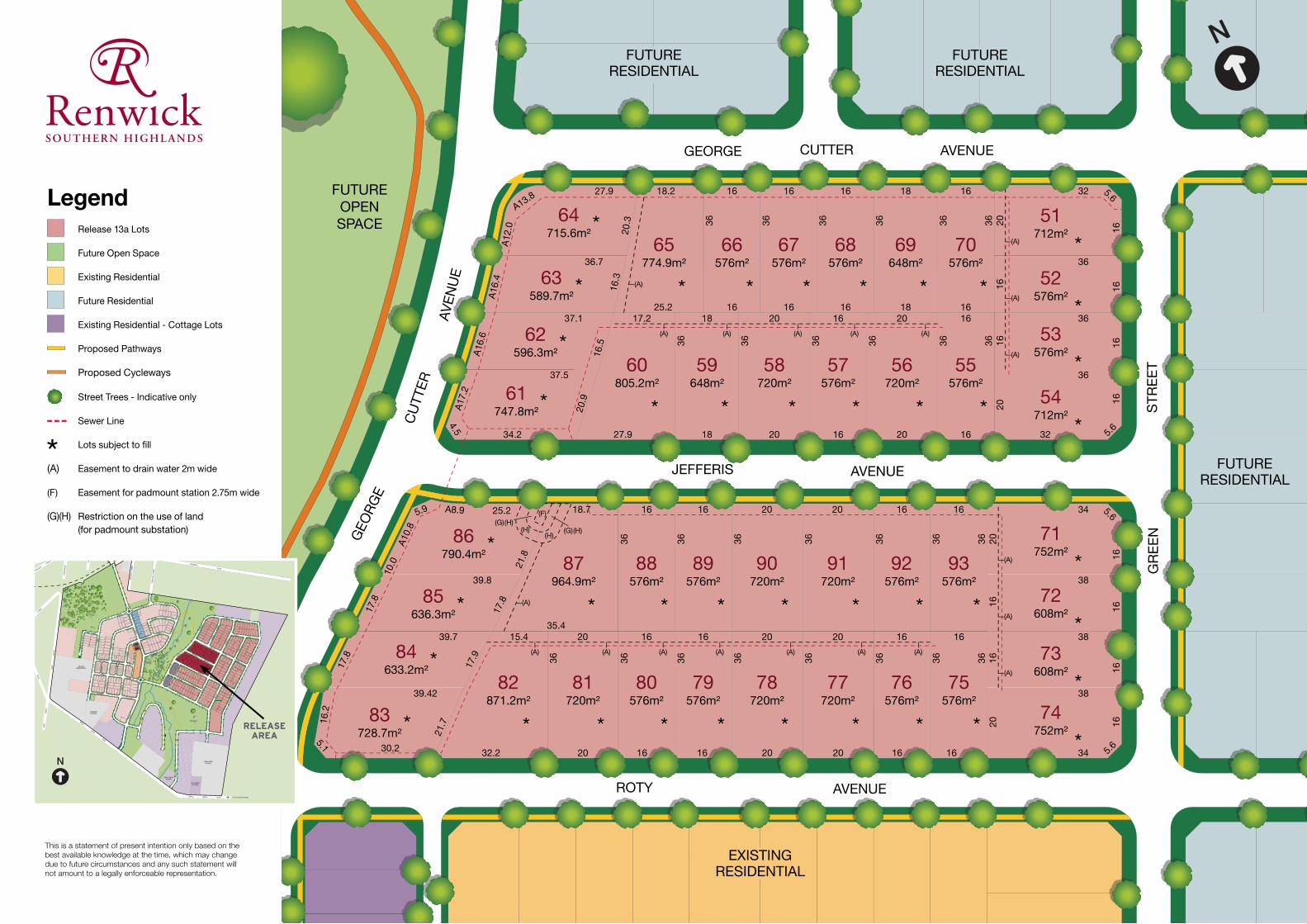
Sales PlanRelease 13a
Printed February 2016
Landcom has proudly printed this brochure on 100% recycled paper using vegetable based inks.
Sales Plan Notes – Release 13a
1. FillandExcavation
All lots have been filled in whole or in part. Intending purchasers should satisfy themselves of any requirement Council may have in relation to building on these lots.
2. LotDimensions
The dimensions shown on the Sales Plan are indicative only. Detailed lot dimensions are shown on the plan of subdivision (known as a Deposited Plan), which is attached to the Land Sales Contract.
3. Design
In order to promote a quality streetscape, all lots are subject to the Renwick Development Control Plan (DCP), which controls aspects of landscaping, fencing and building design. The DCP is available from Wingecarribee Shire Council.
4. Restrictionsonuseofthelots
To ascertain the uses permitted on the lots and controls on development of the lots it is recommended that intending purchasers make enquiries at Council. In addition, Council will be able to advise as to whether any development applications have been lodged in respect of the lot or in respect of nearby lands.
Any person is able to inspect Council’s register of development applications. Details of Major Project Assessments may be found on the website of the NSW Department of Planning.
Certain restrictions on the use of the land can be found in the instrument created at the time of registration of the plan of subdivision under Section 88B of the NSW Conveyancing Act, 1919. Where applicable, a copy of the Section 88B instrument is attached to the Land Sales Contract.
5. FencingCosts
Unless marked on the plan, Landcom will not contribute to the cost of any boundary fencing.
6. Bushfire
To promote community safety, construction on lots 51 - 93 may be subject to standards imposed under the Planning for Bushfire Protection Guidelines (2006), published by the NSW Rural Fire Service. It is recommended that intending purchasers discuss these requirements with Council.
7. Utilityservices
Landcom has met the requirements of Council and the utilities providers in carrying out the subdivision works. The location of utility services, including sewer lines, shown on the plan is based on design information only. The final position of utility services, ‘as constructed’, may vary from these locations. Purchasers should make their own enquiries of utilities providers in relation to:• Utilities connection and service provision to the lot;• The location of utility services; and • Building over, or near, utility services.
8. Landscapingandembellishment
The depiction of landscaping, footpath paving, cycleways, street tree planting, the embellishment of parks, and the like, on the sales plan is indicative only and does not necessarily reflect final designs which require the input of, and approval of, various authorities.
9. SalesProcess
Landcom reserves the right to withdraw any lot from sale at any time.
10.Disclaimer
These notes are for the information of prospective purchasers. The conditions of the Contract for Sale of Land relating to the lots take precedence over these notes. In all instances purchasers must rely on their own enquiries.
landcom.com.au/renwick 4872 1688
Actual on-site image
T +61 2 9212 [email protected]
6 Lacey StreetSurry Hills NSW 2010Australia 21/01/16 A 1:95@A3
RELEASE 13ADD01:10
715.6m
576m
589.7m
596.3m
747.8m
576m
712m
576m
576m
712m
720m576m720m805.2m
790.4m
636.3m
633.2m
728.7m
576m 576m 720m 720m 576m 576m
752m
608m
608m
752m
576m576m720m720m576m576m720m871.2m
774.9m 576m 576m 576m 648m
648m
964.9m
* * * * * * * *
*******
*
*
*
*
*
*
*
*
******
* * * * * *
*
*
*
*
*
*
*
*
(A) (A) (A) (A) (A) (A) (A)
(A) (A) (A) (A) (A)
(A)
(A)
(A)
(A)
(A)
(A)
(A)
(A)
(F)
(H)(H) (H)(G)
(H)(G)
FUTURERESIDENTIAL
EXISTINGRESIDENTIAL
FUTURERESIDENTIAL
FUTURERESIDENTIAL
FUTUREOPENSPACE 51
52
53
54555657585960
61
62
63
6465 66 67 68 69 70
71
72
73
747576777879808182
83
84
85
8687 88 89 90 91 92 93
ROTY AVENUE
GEOR
GE
CUTT
ERAV
ENUE
32 5.6
16
36
2016 16
36
16 16
36
20 16
5.632
36
16
36
16
36
20
20
36
16
16
36
20
20
36
18
20.9
16.5
17.2
27.934.2
4.5
37.5
37.1
36.7
16.3
27.9
20.3
18.2
36
25.2
36
16 16
36
16
3620
34 5.6
16
38
16 16
16
16
38
20 16
5.634
36
16
36
16
36
16
16
36
20
202036
2016
16
363616
16
36
20
20
21.7
17.9
15.4
30.2
5.1
16.2
39.42
17.8
39.7
17.8
39.8
17.8
10.0
5.9 25.221
.818.7
36
16
36
16
36
20
36
20
36
16
36
16
36
35.438
32.2
AVENUEJEFFERIS
GEORGE CUTTER AVENUE
STRE
ETG
REEN
16 16 16 18
1816
18
A16.
6
A12.
0
A13.8
A10.
8
A8.9
A16.
4
A17.
2
36 36
16
This is a statement of present intention only based on the best available knowledge at the time, which may change due to future circumstances and any such statement will not amount to a legally enforceable representation.
DRIV
EG
UTH
AH
AY
PRIVATERESIDENTIAL
SILOS
BELMORE
STREET
FERGUSON
CRESCENT
HIG
HLA
NDE
R
CR
OLD HUME HIGHWAY
RENWICK DRIVEMAIN SOUTHERN RAILWAY
RENW
ICK
LANGLEY
GARRAN
AVENUE
DRIV
E
RENW
ICK
STRE
ET
CU
PITT
STRE
ET
STREET
BOLD
VILLAGEGREEN
MACKELLAR
MACKELLAR
STEWART
STREET
CIRCUIT
TURNER WAY
BOLD
STRE
ET
WALLISAVENUE
DE L
AURE
T
CO
NN
OLL
YPL
ACE
PLACECONNOLLY
BETH
EL L
ANE
OLDFIELD
ROAD
ALLEN
AVENUE
ROTY
AVENUE
GEOR
GE
CUTT
ER
GREE
N
STRE
ET
MAX
TED
GEORGE
CUTTER
AVENUE
STRE
ET
STRE
ET
WIN
DEYE
R
PLUM
B
STREET
CHAL
LONE
R
RISE
ROAD 1301
CH
ALLO
NER
RISE
JEFFERIS
AVENUE
AVENUE
CIRC
UIT
TANGARASCHOOL
BONG
BONG
ROAD
MAR
YST
REET
MITTAGONGGOLF COURSE
AVENUE
BONG BONG ROAD TO OLD SOUTH ROAD
TO SYDNEY
CAM
PBEL
L S
TREE
T
CAR
DIG
AN
STRE
ET
INKERMAN
ROAD
BONG
BONG
ROAD
MAR
YST
REET
HIGHLANDSSCHOOL
DE LAURETCOTTAGE
CHALLONERHOUSE
MAX
TED
STRE
ET
TO M
ITTAGONG
RELEASEAREA
Legend Release 13a Lots
Future Open Space
Existing Residential
Future Residential
Existing Residential - Cottage Lots
Proposed Pathways
Proposed Cycleways
Street Trees - Indicative only
Sewer Line
Lots subject to fill
(A) Easement to drain water 2m wide
(F) Easement for padmount station 2.75m wide
(G)(H) Restriction on the use of land (for padmount substation)