ryerson church transportation assessment and management … · considered, as well as the impacts...
TRANSCRIPT

Ryerson Church
Transportation Assessment and Management Study Version 1.0
Prepared for
Ryerson United Church
Date
December 20, 2016
Project No.
4827-07

Ryerson Church Rezoning |Transportation Assessment and Management Study | 15 December 2016 S:\PROJECTS\BP\4826-07 Ryerson Church TAMS\5.0 Deliverables\20160212_4827-07_Ryerson_Church_TAMS_RPT PJ[2].docx
December 20, 2016
4827-07
Malcolm Elliot
Principal
Endall Elliot Associates
910b Richards Street
Vancouver BC
V6B 3C1
Dear Malcolm:
Re: Ryerson Church Rezoning
Transportation Assessment and Management Study
Please find attached our Transportation Assessment and Management Study. We have reviewed the
anticipated transportation impact of the proposed Ryerson Church redevelopment and our resulting
findings and recommendations are provided in the attached report.
Yours truly,
Bunt & Associates
for/
Brian Elery Phillips, MSc. Peter Joyce, P.Eng.,
Transportation Analyst Principal

Ryerson Church Rezoning |Transportation Assessment and Management Study | 15 December 2016 S:\PROJECTS\BP\4826-07 Ryerson Church TAMS\5.0 Deliverables\20160212_4827-07_Ryerson_Church_TAMS_RPT PJ[2].docx

Ryerson Church Rezoning |Transportation Assessment and Management Study | 15 December 2016 S:\PROJECTS\BP\4826-07 Ryerson Church TAMS\5.0 Deliverables\20160212_4827-07_Ryerson_Church_TAMS_RPT PJ[2].docx
This document was prepared by Bunt & Associates for the benefit of the Client to whom it is addressed. The copyright and ownership of the report rests with Bunt & Associates. The information and data in the report reflects Bunt & Associates’ best professional judgment in light of the knowledge and information available to Bunt & Associates at the time of preparation. Except as required by law, this report and the information and data contained are to be treated as confidential and may be used and relied upon only by the client, its officers and employees. Any use which a third party makes of this report, or any reliance on or decisions made based on it, are the responsibilities of such third parties. Bunt & Associates accepts no responsibility for damages, if any, suffered by any third party as a result of decisions made or actions based on this report.
CORPORATE AUTHORIZATION
Prepared By: Brian Elery Phillips, M.Sc. Bunt & Associates Engineering (BC) Ltd.
1550-1050 West Pender Street
Vancouver, BC V6E 3S7
Canada
Reviewed By: Peter Joyce, P.Eng., PTOE Telephone: +1 604 685 6427
Principal Facsimile: +1 604 685 6579
Date: 2016/12/20
Project No. 4827-07
Status: Draft

Ryerson Church Rezoning |Transportation Assessment and Management Study | 15 December 2016 S:\PROJECTS\BP\4826-07 Ryerson Church TAMS\5.0 Deliverables\20160212_4827-07_Ryerson_Church_TAMS_RPT PJ[2].docx
TABLE OF CONTENTS
1. REPORT CONTEXT ................................................................................................ 1
1.1 Study Purpose, Scope & Objectives ....................................................................................................... 1
1.2 Organization of Report ......................................................................................................................... 3
1.3 Proposed Development ........................................................................................................................ 3
2. EXISTING CONDITIONS ......................................................................................... 5
2.1 Land Use .............................................................................................................................................. 5
2.2 Existing Transportation Network .......................................................................................................... 6
2.2.1 Road Network .......................................................................................................................... 6
2.2.2 Transit Network ....................................................................................................................... 7
2.2.3 Cycling & Pedestrian Networks ................................................................................................ 9
2.3 Data Collection ..................................................................................................................................... 9
2.3.1 Traffic Data Collection Program ............................................................................................... 9
2.3.2 Peak Hour Traffic Volumes ...................................................................................................... 9
2.4 Existing Operations ............................................................................................................................ 11
2.4.1 Performance Thresholds ........................................................................................................ 11
2.4.2 Operational Analysis Results ................................................................................................. 12
3. FUTURE TRAFFIC ................................................................................................ 14
3.1 Traffic Forecasts ................................................................................................................................. 14
3.1.1 Background Traffic ................................................................................................................ 14
3.1.2 Site Traffic ............................................................................................................................. 14
4. TRANSPORTATION IMPACT ................................................................................. 15
4.1 Traffic Impact ..................................................................................................................................... 15
4.2 Parking ............................................................................................................................................... 15
4.2.1 Residential Parking ................................................................................................................ 15
4.2.2 Church/Activity Centre Parking .............................................................................................. 16
4.2.3 Summary ............................................................................................................................... 17
4.2.4 Bicycle Parking ...................................................................................................................... 18
4.3 Parking Layout & Vehicle Circulation .................................................................................................. 19
4.4 Service Vehicle Operations ................................................................................................................. 19

Ryerson Church Rezoning |Transportation Assessment and Management Study | 15 December 2016 S:\PROJECTS\BP\4826-07 Ryerson Church TAMS\5.0 Deliverables\20160212_4827-07_Ryerson_Church_TAMS_RPT PJ[2].docx
5. TDM & ACTIVE MODES ........................................................................................ 22
5.1.1 Walking & Cycling .................................................................................................................. 22
5.1.2 Transit ................................................................................................................................... 23
6. CONCLUSIONS & RECOMMENDATIONS ................................................................ 23
6.1 Conclusions ....................................................................................................................................... 23
EXHIBITS Exhibit 1.1: Site Location ........................................................................................................................................ 2
Exhibit 1.2: Study Area ........................................................................................................................................... 2
Exhibit 1.3: Site Accesses ....................................................................................................................................... 4
Exhibit 2.1: Detail of City of Vancouver Zoning Map July 21, 2016 .......................................................................... 5
Exhibit 2.2 Existing On Street Parking Supply .......................................................................................................... 6
Exhibit 2.3: Existing Traffic Control ........................................................................................................................ 7
Exhibit 2.4: Transit Routes & Stops ........................................................................................................................ 8
TABLES Table 1.3: Proposed Land Uses ............................................................................................................................... 3
Table 1.4: Proposed Parking Supply ........................................................................................................................ 4
Table 2.1: Existing Street Characteristics ................................................................................................................. 6
Table 2.2: Transit Stops within 800m Walking Distance of Site ............................................................................... 8
Table 2.3: Existing Transit Service Frequency .......................................................................................................... 8
Table 2.4: Summary of Available and Counted Traffic Data .................................................................................... 9
Table 2.5: Existing Peak Hour Roadway Link Volumes ............................................................................................. 9
Table 2.7: Intersection Level of Service Thresholds............................................................................................... 11
Table 2.8: Existing Traffic Operations – Unsignalized Intersections ....................................................................... 12
Table 3.1: Peak Hour Vehicle Trip Rates ................................................................................................................ 14
Table 3.2: Estimated Peak Hour Site Vehicle Trips ................................................................................................. 14
Table 4.1: Vehicle Parking Supply Requirement & Provision (rental building) ......................................................... 15
Table 4.2: Vehicle Parking Supply Requirement & Provision (condo building) ........................................................ 16
Exhibit 4.1: Observed Friday and Saturday Night Parking Demand ........................................................................ 17
Table 4.3: Summary of Site Parking Provision ........................................................................................................ 18
Table 4.2: Bicycle Parking Supply Provision ........................................................................................................... 18
Table 4.3: Loading Bylaw Rates ............................................................................................................................. 19
Table 5.1: Walking Thresholds ............................................................................................................................. 22

1. REPORT CONTEXT
1.1 Study Purpose, Scope & Objectives
Ryerson United Church, in partnership with Wall Financial, is seeking to redevelop its existing property in
Kerrisdale, Vancouver BC. The property consists of two sites, both located on the north side of 45th
Avenue, on either side of Yew Street. The west property (2195 W 45th Avenue) is occupied by the church
building and three single family homes. The east side (2173 W 45th Avenue) contains Ryerson Memorial
Centre and Gym (i.e., the activity centre), and one single family home (2163 W 45th Avenue).
The proposed redevelopment calls for a new activity centre to replace the existing one, along with 40
market condominium units and 32 rental units, some of which will provide subsidized housing. The single
family homes will be removed as part of the redevelopment.
The purpose of this study is to examine this project’s impact on the surrounding transportation network
as input to the planning and engineering consideration of the site development application.
Exhibit 1.1 shows the site location in relation to the surrounding major streets. Exhibit 1.2 shows the
traffic impact study area. The impacts of site traffic on 45th Avenue from the site to West Boulevard are
considered, as well as the impacts on Yew Street from the site to 41st Avenue. For the purposes of on-
street parking evaluation, an area within a one block radius of the site was considered.
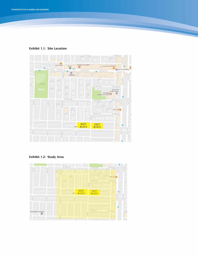
Exhibit 1.1: Site Location
Exhibit 1.2: Study Area

1.2 Organization of Report
After a brief description on the context of this report, the condition of the existing transportation network
surrounding Ryerson Church is given. This consists of a description of the existing road operations, as
well as the transit, cycling, and pedestrian networks serving the area. Next the new demand for travel
created by the new residential units is forecasted, and the impact of this new demand is described, both in
terms of road operation and on-street parking. The impact section also analyzes the on-site works. Finally,
a description of the project’s TDM plan is given.
1.3 Proposed Development
The proposed development consists of the existing church, an activity centre to replace the Ryerson
Memorial Centre and Gym, and two new multifamily residential buildings: one 40-unit condominium
building, and one 32-unit rental apartment building. Table 1.3 summarizes the development.
Table 1.3: Proposed Land Uses
LAND USE FSR AREA (SF) UNITS
Condominium Residential 74,460 40
Rental Residential 25,437 32
Activity Centre 18,703 -
Existing Church 13,338 -
The majority of parking for the development will be in an underground parking structure on the east side,
beneath the condominium buildings. Access to this site will be through via the lane to the north of the
site. The west site, which includes the rental apartments, activity centre, and existing church, will have a
loading access, disability parking, and 5 reserved parking spaces accessible by the lane to the north of the
site. Table 1.4 gives the proposed parking supply, while Exhibit 1.3 indicates the site plan, with both site
accesses.

Table 1.4: Proposed Parking Supply
USE AREA/UNITS PROPOSED PARKING
STALLS
Rental Units 32 units 12
Condominium Units 40 units 80
Church/Activity Centre 18,703 sf 45
TOTAL - 137
Exhibit 1.3: Site Accesses
The development is expected to be completed in 2020.

2. EXISTING CONDITIONS
2.1 Land Use
Ryerson Church and Ryerson Memorial Centre are situated on West 45th Avenue, on either side of Yew
Street. They are located within a single-family residential neighbourhood (RS-3 zoning), on the border of a
medium-density (RM-3) area. Commercial land uses (C-2) are located along the two nearest major streets,
at West Boulevard and at 41st Avenue. Exhibit 2.1 shows a detail of the City of Vancouver Zoning Map (June
2016), with the site location indicated.
Neither site has on-site parking accommodation for visitors. The Memorial Centre has a small number of
parking stalls available on the lane that are reserved for ministers and facilities staff. Currently, visitors
arriving by motor vehicle use on-street parking throughout the neighbourhood.
Exhibit 2.1: Detail of City of Vancouver Zoning Map July 21, 2016

2.2 Existing Transportation Network
2.2.1 Road Network
The road network surrounding Ryerson Church consists mainly of 2-lane local streets with parking on both
sides. The nearest collector streets are 41st Avenue and West Boulevard, of which 41st Avenue is a
designated truck route. Table 2.1 lists the streets in the nearby road network.
Table 2.1: Existing Street Characteristics
STREET CLASSIFICATION NUMBER OF
TRAVEL LANES POSTED SPEED PARKING FACILITIES
42nd Avenue Local 2 50 km/h On street
43rd Avenue Local 2 50 km/h On street
44th Avenue Local 2 50 km/h On street
45th Avenue Local 2 50 km/h On street
Yew Street Local 2 50 km/h On street
Vine Street Local 2 50 km/h On street
41st Avenue Collector 4 50 km/h On Street
West Boulevard Collector 1 50 km/h On street, one side
Exhibit 2.2 shows the results of the of on-street parking inventory.
Exhibit 2.2 Existing On Street Parking Supply

Exhibit 2.3: Existing Traffic Control
2.2.2 Transit Network
As identified in Exhibit 2.4, there are three transit routes operating within 800m of the site, all of them
part of the Frequent Transit Network. 41st Avenue, West Boulevard, and 49th Avenue all have bus service.
Table 2.2 below lists the nearest bus stops on each of these streets. While these bus stops are located
some distance away, they are still within reasonable walking distance. Once at the bus stop, all routes in
the area operate with relatively low headways.

Table 2.2: Transit Stops within 800m Walking Distance of Site
STOP LOCATION DIRECTION STOP # AMENITY ROUTES
SERVICED WALKING DISTANCE
41st Avenue & Yew Street EB 50381 None 41 650m
41st Avenue & Vine Street WB 50290 None 41 650m
45th Avenue & West Blvd. NB 51020 Shelter 16 270m
45th Avenue & West Blvd. SB 51109 None 16 270m
49th Avenue & Yew Street EB 51953 None 49 450m
49th Avenue & West Boulevard WB 52045 Shelter 49 600m
Table 2.3: Existing Transit Service Frequency
ROUTE STOP
WEEKDAY SERVICE HEADWAY (MIN.)
# DIRECTION START END AM MID-DAY
PM EVENING WEEKEND
41 EB 50381 4:39 1:59 5 min 7 min 7 min 10 min 8 min
41 WB 50290 4:39 1:59 5 min 7 min 7 min 10 min 8 min
16 NB 51020 4:54 1:04 9 min 10 min 6 min 19 min 10 min
16 SB 51109 5:21 12:45 9 min 10 min 6 min 19 min 10 min
49 EB 51953 6:26 11:52 7 min 10 min 9 min 12 min 12 min
49 WB 52045 5:53 12:15 7 min 10 min 9 min 12 min 12 min
Exhibit 2.4: Transit Routes & Stops

2.2.3 Cycling & Pedestrian Networks
Forty-fifth Avenue adjacent the site as part of the Ridgeway Greenway which is designated as a
local street bikeway- a local street where cyclists share the road with light traffic. On the rest of
the network, there are sidewalks on both sides of the street provided for pedestrians, with
pedestrian controlled crossing signals at 41st Avenue and Yew Street, and at 45th Avenue and West
Boulevard.
2.3 Data Collection
2.3.1 Traffic Data Collection Program
Traffic counts were conducted on Tuesday, 13 December 2016. Despite the previous week’s
snows, the roads were dry and in good condition. Traffic counts from previous years showed
similar volumes, indicating that volumes were significantly affected by the weather conditions at
the time of the count.
Table 2.4: Summary of Available and Counted Traffic Data
INTERSECTION DATE OF COUNT PEAK HOURS
AM PM
41st Avenue/Yew Street 13 December 2016 8:00 15:00
Lane north of site/Yew Street 13 December 2016 8:00 15:00
45th Avenue/Yew Street 13 December 2016 8:00 15:00
45th Avenue/West Boulevard 13 December 2016 8:00 15:00
OVERALL STUDY AREA PEAK HOUR 8:00 15:00
2.3.2 Peak Hour Traffic Volumes
Table 2.5 presents a summary of the two-way peak-hour vehicle movements for the streets in the study
area.
Table 2.5: Existing Peak Hour Roadway Link Volumes
ROAD LINK PEAK LINK VOLUMES (VEH/HR)
AM PM
45th Avenue between Yew Street and West Boulevard 116 125
Yew Street, just north of the site 55 40
Exhibit 2.5 summarizes the existing weekday afternoon peak hour traffic volume in the area as observed
by Bunt on the December 13/16 survey date.

&
S:\
PR
OJE
CTS\B
P\4
826-0
7 R
yers
on C
hurc
h T
AM
S\5
.0
Delivera
ble
s\G
raphic
s
Scale: NTS
N
4827-07Ryerson Church TAMS
Exhibit 2.5
Existing Weekday PM Peak Hour Traffic Volume
December 2016
Freeway
Highway
Arterial
Collector
Local
Railway
ProposedExisting
Use this font and size for road names
41st Avenue
42nd Avenue
43rd Avenue
44th Avenue
45th AvenueYew
Str
eet
West
Boule
vard
use this to outline site etc
West Site East Site
000
000
000
000
000
000
000 000000
000000000
00
000
000
000000
000000
00
(000) 00
000(000)
000(000)
(000)000
(0,000)0,000
0,000(0,000)
000(000)
000(000)0,000
(0,000)
(000)000
(000)000
(0,000)0,000
00
000 (000)
(000) 000
0,000(0,000)
0,000(0,000)
(000)000
(000)000
00
(000)000
(000)000
(000)000
000 (000)
000 (000)
(000) 000
(000) 000
(000) 000
000 (000)
000(000)
000(000)000
(000)
00
544 (428)
755(569)
1
23(37)
72(84)
30(79)
57(34)
0 (0)
0(0)
46(40)
(59)29
2
0(2)
0(2)
2(5)
8(0)(1)
1
(0)1
4(1)
1 (0)
84 (90)
86(66)
35(20)
(26)17
3
15(12)
13(10)
3(4)
4(18)(28)
12
(11)8
5(5)
8 (6)
69 (60)
55(49)
538(428)
(490)385
4
35(26)
22(35)
8(14)
79(77)(83)
75
(30)17
32(52)
15 (13)
Lane
*Note: some lanes omitted for clarity
000
0000,000
0,000
A
A
0.3
1
A()
0.3
1
A()
0.3
1
A()
0.3
1
A()
0.31 A( )
0.31 A( )
0.31 A( )
0.31 A( )
0.3
1
A()
0.3
1
A()
0.3
1
A()
0.3
1
A()
0.31 A( )
0.31 A( )
0.31 A( )
0.31 A( )
0.3
1
A()
0.3
1
A()
0.3
1
A()
0.3
1
A()
0.31 A( )
0.31 A( )
0.31 A( )
0.31 A( )
14
0.79A
0.79A
0.3
1 A()
0.3
1 A()
0.3
1 A()
0.3
1 A()
0.31 A( )
0.31 A( )
0.31 A( )
0.31 A( )
0.3
1 A()
0.3
1 A()
0.3
1 A()
0.3
1 A()
0.31 A( )
0.31 A( )
0.31 A( )
0.31 A( )
0.3
1 A()
0.3
1 A()
0.3
1 A()
0.3
1 A()
0.31 A( )
0.31 A( )
0.31 A( )
0.31 A( )
16
0.79
A
0.79
A
0.3
1 A()
0.3
1 A()
0.31 A()
0.31 A()
0.31 A()
0.31 A()
0.31 A()
0.31 A()
0.3
1 A()
0.3
1 A()
0.31 A()
0.31 A()
12
Notes:AM Peak Hour: X to YPM Peak Hour: X to Y
Pedestrian Signal
Traffic Signal
Intersection #
Link Volumes
Unsignalized
000(000)
00
00000000
AMPM
AMPM Intersection Volumes
2 Way Stop
All Way Stop
Roundabout
Pedestrian Signal
Traffic Signal
Intersection #
Link Volumes
00
000(000)00000000
AMPM
AMPM Intersection Volumes
Pedestrian Signal
Traffic Signal
Unsignalized
Two Way Stop
All Way Stop
Roundabout
Pedestrian Signal
Traffic Signal
Storage Length (m)
00
00
00
(#) (#) Freeway
Highway
Arterial
Collector
Local
Railway
Two Way Stop
All Way Stop
Roundabout
Pedestrian Signal
Traffic Signal
Proposed
Freeway
Highway
Arterial Road
Collector Road
Local Road
Road style 1
Road style 2
Road style 3
Unsignalized
Pedestrian Signal
Traffic Signal
ExistingExisting ProposedProposed Existing
Use this font and size for road names
LOS A to D V/C <0.85 LOS E V/C >0.85<0.90LOS F V/C >0.90
0.89
C
0.9
1
F()
0.54 B( )
0.7
0(
)D*
Lane Group LOS
Lane Group V/C
Lane Group
Overall V/C
Overall LOS
th95 % Queueexceeds availablestorage
Freeway
Expressway
Arterial
Collector
Local
Railway
ProposedExisting
Use this font and size for road names
0,000(0,000)
(0,000)0,000
88
000(000)
000(000)
000(000)
(000) 000
0,000(0,000)
(0,000)0,000
88
000(000)
(000)000
000(000)
000 (000)
0,000 (0,000)
0,000(0,000)
88
000(000)
(000) 000
(000)000
000 (000)
000
0000,000
0,000
0.31 A( )
0.31 A( )
0.31 A( )
0.31 A( )
0.3
1
A()
0.31 A( )
0.3
1
A()
0.31 A( ) 0.3
1
A()
0.3
1
A()
0.3
1
A()
0.3
1
A()
0.31A
0.31A
0.31 A( )
0.31 A( )
0.31 A( )
0.31 A( )
0.3
1
A()
0.3
1
A()
0.31A
0.3
1
A()
0.3
1
A()
0.31 A( )
0.31 A( ) 0.3
1
A()
0.3
1
A()
0.31A
0.3
1
A()
0.3
1
A()
0.31 A( )
0.31 A( )
0.31 A( )
0.31 A( )
0.31A
0.3
1
A()
0.3
1
A()
0.3
1
A()
0.3
1
A()
0.31 A( )
0.31 A( )
For HCM 2000 unsignalized intersections,
choose the circle below without the overall
v/c metric in the centre of the circle.
0.31 A( )
0.31 A( )
0.31 A( )
0.31 A( )
0.3
1
A()
0.31 A( )
0.3
1
A()
0.31 A( ) 0.3
1
A()
0.3
1
A()
0.3
1
A()
0.3
1
A()
A
Please align arrowheads when creating lane
groups not present in this template as shown
below using grid guides.
Note: Arrows reflect “Lane Groups” defined
by Synchro and NOT roadway laning.
Please align arrowheads when creating lane
diagrams not present in this template as
shown below using grid guides.
Draw Freeway - assign 6.0pt black
Duplicate line with ”+” - assign 0.5pt white
Pedestrian Signal
Traffic Signal
Intersection #
Link Volumes
Unsignalized
000(000)
00
00000000
AMPM
AMPM Intersection Volumes
Intersection #
00
000(000)
AMPM Intersection Volumes
LOS A to D V/C < 0.85 LOS E 0.85 < V/C < 0.90LOS F V/C > 0.90
0.89
C
0.9
1
F()
0.54 B( )
0.8
6E() *
Lane Group LOS
Lane Group V/C
Lane Group
Overall V/C
Overall LOS
th95 % Queue
exceeds available
storage
Pedestrian Signal
Traffic Signal
Unsignalized
00
00
00
Two Way Stop
All Way Stop
Roundabout
Pedestrian Signal
Traffic Signal
Storage Length (m)(#) (#)
Existing Proposed
Freeway
Expressway
Arterial
Collector
Local
Railway
Two Way Stop
All Way Stop
Roundabout
Pedestrian Signal
Traffic Signal
ProposedExisting
Freeway
Expressway
Arterial Road
Collector Road
Local Road
Road style 1
Road style 2
Road style 3
Railway
Unsignalized
Pedestrian Signal
Traffic Signal
Existing Proposed
Freeway
Expressway
Arterial Road
Collector Road
Local Road
Road style 1
Road style 2
Road style 3
Railway
Unsignalized
Pedestrian Signal
Traffic Signal
Existing
Draw railway alignment assign 1.0pt black
Draw 0.05” ticks at start and end assign 0.5pt black
Use “Blend”, drag from first tick to second tick and set path
to follow railway alignment. Adjust count so spacing is 0.2”
2 Way Stop
All Way Stop
Roundabout
Pedestrian Signal
Traffic Signal
Intersection #
Link Volumes
00000000
000(000)00000000
AMPM
AMPM Intersection Volumes
00
Legends for Future Conditions Legends for Existing Conditions
Arterial
Collector
Local
Lane
Two Way Stop
All Way Stop
Pedestrian Signal
Traffic Signal
Existing

2.4 Existing Operations
2.4.1 Performance Thresholds
The existing operations of study area intersections and access points were assessed using the methods
outlined in the 2000 Highway Capacity Manual (HCM), using the Synchro 9 analysis software. The traffic
operations were assessed using the performance measures of Level of Service (LOS) and volume-to-
capacity (V/C) ratio.
The LOS rating is based on average vehicle delay and ranges from “A” to “F” based on the quality of
operation at the intersection. LOS “A” represents optimal, minimal delay conditions while a LOS “F”
represents an over-capacity condition with considerable congestion and/or delay. Delay is calculated in
seconds and is based on the average intersection delay per vehicle.
Table 2.7 below summarizes the LOS thresholds for the five Levels of Service, for both signalized and
unsignalized intersections.
Table 2.7: Intersection Level of Service Thresholds
LEVEL OF SERVICE AVERAGE CONTROL DELAY PER VEHICLE (SECONDS)
SIGNALIZED UNSIGNALIZED
A ≤10 ≤10
B >10 and ≤20 >10 and ≤15
C >20 and ≤35 >15 and ≤25
D >35 and ≤55 >25 and ≤35
E >55 and ≤80 >35 and ≤50
F >80 >50
Source: Highway Capacity Manual
The volume to capacity (V/C) ratio of an intersection represents ratio between the demand volume and the
available capacity. A V/C ratio less than 0.85 indicates that there is sufficient capacity to accommodate
demands and generally represents reasonable traffic conditions in suburban settings. A V/C value
between 0.85 and 0.95 indicates an intersection is approaching practical capacity; a V/C ratio over 0.95
indicates that traffic demands are close to exceeding the available capacity, resulting in saturated
conditions. A V/C ratio over 1.0 indicates a very congested intersection where drivers may have to wait
through several signal cycles. In downtown and Town Centre contexts, during peak demand periods, V/C
ratios over 0.90 and even 1.0 are common.
In interpreting of the analysis results, note that the HCM methodology reports performance differently for
various types of intersection traffic control. In this report, the performance reporting convention is as
follows:
For signalized intersections: HCM 2000 output for overall LOS and V/C as well as individual
movement LOS and V/C is reported. 95th Percentile Queues are reported as estimated by
Synchro;

For unsignalized two-way stop controlled intersections: HCM 2000 LOS and V/C output is
reported just for individual lanes as the HCM methodology does not report overall performance.
SimTraffic estimated queues and delays have also been reported, as the HCM 2000 methodology
does not directly take into account the gaps afforded by adjacent signalized intersections;
2.4.2 Operational Analysis Results
Table 2.8 below presents the existing traffic operations on the study network. Due to high pedestrian
volumes at 45th Avenue and West Boulevard, it was modelled as a signalized intersection; the peak hour
volumes for pedestrians crossing West Boulevard at the pedestrian signal were 99 in the AM peak and 155.
With pedestrians arriving on average every 36 or 23 seconds (AM and PM respectively), the pedestrian
signal will be actuated frequently.
Overall, the network is operating in good condition, with ample capacity at all intersections.
Table 2.8: Existing Traffic Operations – Unsignalized Intersections
INTERSECTION/ TRAFFIC CONTROL
MOVEMENT
AM PM
LOS V/C 95TH Q
(M) LOS V/C
95TH Q (M)
41st Avenue & Yew Street
EBT A 0.38 0 A 0.30 0
EBR A 0.38 0 A 0.30 0
WBL A 0.04 0.8 A 0.08 2
WBT A 0.32 0.8 A 0.24 2
NBL C 0.31 9.7 C 0.34 11.4
NBR C 0.31 9.7 C 0.34 11.4
Lane north of site & Yew Street
EBL A 0 0.1 A 0 0
EBT A 0 0 A 0 0
EBR A 0 0.1 A 0 0
WBL A 0.01 0.3 A 0.01 0.1
WBT A 0 0 A 0 0.1
WBR A 0.01 0.3 A 0 0.1
NBL A 0 0 A 0 0
NBT A 0 0 A 0 0
NBR A 0 0 A 0 0
SBL A 0 0 A 0 0
SBT A 0 0 A 0 0
SBR A 0 0 A 0 0

45TH AVENUE & YEW STREET
EBL A 0.01 0.1 A 0 0.1
EBT A 0.01 0.1 A 0 0.1
EBR A 0.01 0.1 A 0 0.1
WBL A 0 0 A 0 0.1
WBT A 0 0 A 0 0.1
WBR A 0 0 A 0 0.1
NBL B 0.09 2.3 B 0.06 1.5
NBT B 0.09 2.3 B 0.06 1.5
NBR B 0.09 2.3 B 0.06 1.5
SBL B 0.06 1.3 B 0.10 2.4
SBT B 0.06 1.3 B 0.10 2.4
SBR B 0.06 1.3 B 0.10 2.4
45TH Avenue & West Boulevard
OVERALL A 0.55 - A 0.54 -
EBL B 0.32 18.7 C 0.43 6.3
EBT B 0.32 18.7 C 0.43 6.3
EBR B 0.32 18.7 C 0.43 6.3
WBL B 0.36 17.6 C 0.46 5.4
WBT B 0.36 17.6 C 0.46 5.4
WBR B 0.36 17.6 C 0.46 5.4
NBL A 0.56 54.2 A 0.41 16.7
NBT A 0.56 54.2 A 0.41 16.7
NBR A 0.56 54.2 A 0.41 16.7
SBL A 0.51 42.5 A 0.55 24.3
SBT A 0.51 42.5 A 0.55 24.3
SBR A 0.51 42.5 A 0.55 24.3

3. FUTURE TRAFFIC
3.1 Traffic Forecasts
3.1.1 Background Traffic
Background traffic is traffic that would be present on the road network regardless of whether or not the
proposed development proceeds. Traffic growth is not expected to grow significantly in the area.
According to the list of active development permits on the City of Vancouver website, there are two active
developments within 1 km of the site: one single family housing renovation (6788 Beechwood Street) and
40-unit mixed use development at 6333 West Boulevard. There are no expected changes to the study area
road network. City of Vancouver traffic volume data over the past several years at key intersections in the
area has been relatively stable with minimal if any increase in traffic year over year.
3.1.2 Site Traffic
TripGeneration
Since the church and activity are already in operation, the new residences are expected to be the source of
most if not all of the new traffic generated by the site. For the subsidized apartments, a reduced rate was
used for trip generation that is in line with the minimal parking provision proposed for these units as
vehicle ownership levels are anticipated to be low.
Table 3.1: Peak Hour Vehicle Trip Rates
LAND USE UNITS AM PEAK HOUR PM PEAK HOUR
IN OUT TOTAL IN OUT TOTAL
Highly Subsidized Rental 10 0 0.1 0.1 0.1 0 0.1
Mid Subsidized Rental 11 0.05 0.15 0.2 0.15 0.05 0.2
Market Rental Housing 11 0.08 0.22 0.3 0.21 0.14 0.35
Strata Housing 40 0.07 0.37 0.44 0.35 0.17 0.52
Table 3.2 summarizes the anticipated future site generated vehicle trips for the proposed development
based on the above rates. As indicated, the net additional vehicle trips anticipated for the project are in
the range of 20-25 vehicles per hour during both the weekday morning and afternoon peak periods.
Table 3.2: Estimated Peak Hour Site Vehicle Trips
LAND USE AM PEAK HOUR PM PEAK HOUR
IN OUT TOTAL IN OUT TOTAL
Highly Subsidized Rental 0 1 1 1 0 1
Mid Subsidized Rental 0.55 1.65 2.2 1.65 0.55 2.2
Market Rental Housing 0.88 2.42 3.3 2.31 1.54 3.85
Strata Housing 2.8 13.2 16 10.8 5.2 16
23 23

4. TRANSPORTATION IMPACT
4.1 Traffic Impact
The additional traffic generated by this site is within the expected daily variation in traffic. At 23 additional
trips in the daily peak hour, this site will be adding less than one car to the road every 2 minutes. As such,
the impact of traffic on the overall road system is negligible.
4.2 Parking
4.2.1 Residential Parking
The parking supply for the rental and strata buildings is presented in Tables 4.1 and 4.2
respectively. Parking provision for the subsidized housing is based on Bunt & Associates’ recent
experience with social housing in the City of Vancouver. For highly subsidized housing units, the
rate of parking supply matches that of the recently completed Budzey Building. Mid-subsidized
units are given a slightly higher ratio.
Parking provision for strata units is set at two stalls per dwelling unit, which is more than required
by the Parking Bylaw.
Table 4.1: Vehicle Parking Supply Requirement & Provision (rental building)
UNIT TYPE # DWELLING UNITS PARKING BYLAW
REQUIREMENT # STALLS REQUIRED
PROPOSED RATIO STALLS
PROPOSED
Rental units – Highly Subsidized 10 ‘A minimum of 0.5 space
for every dwelling unit that has less than 50 m² of gross floor area, and, for every dwelling unit
that has 50 m² or more of gross floor area, at least
0.6 space for every dwelling unit plus one
space for each 200 m² of gross floor area, except that, for every dwelling unit which has a gross floor area of 180 m² or
greater, there need be no more than 1.5 spaces for
every dwelling unit.’
27
0.1 1
Rental units – Mid Subsidized 11 1/6 1.8
Market Rental 11 0.5 5.5
Sub Total 32 - 8.3
Visitor - - 3.2
TOTAL 270 - 27 12

Table 4.2: Vehicle Parking Supply Requirement & Provision (condo building)
UNIT TYPE # DWELLING UNITS PARKING BYLAW
REQUIREMENT # STALLS REQUIRED
PROPOSED RATIO STALLS
PROPOSED
<180 sm 31 0.6 18 2/unit 62
>180 sm 9 1.5 13.5 2/unit 18
Total Area 3854 sm 1/200 19.3 0 0
TOTAL 270 - 51.37 80
4.2.2 Church/Activity Centre Parking
Bunt & Associates performed research in 2016 to determine the peak parking demand generated by the
existing church and activity centre. Parking counts were undertaken during the weekday and weekend
evenings and Sunday mornings for seven days throughout 2016. The peak parking demand generated by
the church and activity centre was observed to occur during performance events, such as concerts or
theatre performances. The study area was a rectangular area extending one block in each direction from
the church.
Parking counts were taken on nights with and without scheduled events to develop a baseline of parking
usage from the neighbourhood- the difference between parking utilization during events and not during
events was considered to be the demand generated by the event itself. Exhibit 4.1 shows the parking
demand for the critical period- during Saturday of Friday nights. Parking Utilization on the non-event night
was steady throughout the period at around 50%. During the two event nights observed, parking demand
was higher, but remained well below 80%, the point at which on-street parking is considered to be
congested.
That parking utilization never exceeded congestion verifies our study area; if parking in the study area
became congested, some event attendees would likely have parked farther away and been missed by our
counts. Instead, it can be assumed that our counts accurately captured parking demand generated by the
events. Additionally, congested parking conditions would indicate that there may be additional demand for
parking that is suppressed by its scarcity. This latent demand would be activated by the provision of
additional parking, as is proposed by this development. However, since event attendees were able to find
parking close to the site, it can be assumed that there is no demand suppressed due to lack of parking.

Exhibit 4.1: Observed Friday and Saturday Night Parking Demand
The June event, which took place on a Saturday, represents the greatest observed parking demand. The
peak parking usage in the study area was 382 cars, of which 114 can be attributed to the event itself.
45 parking stalls for church and activity centre use are proposed for this development. It is expected that
event attendees will continue to utilize on-street parking during large events, though to a lesser extent.
The majority of site-generated traffic utilizes parking on Vine Street, Yew Street, and 45th Avenue directly
fronting the site, which is expected to continue to be the preferred on-street parking location. Providing
off-street parking for approximately 40% of the observed peak demand will limit the impact for
surrounding areas.
4.2.3 Summary
Table 4.3 indicates the total off-street parking proposed for the development, exclusive of handicap
spaces and loading bays. A total of 137 off-street parking spaces are provided.
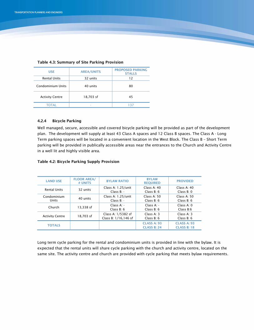
Table 4.3: Summary of Site Parking Provision
USE AREA/UNITS PROPOSED PARKING
STALLS
Rental Units 32 units 12
Condominium Units 40 units 80
Activity Centre 18,703 sf 45
TOTAL - 137
4.2.4 Bicycle Parking
Well managed, secure, accessible and covered bicycle parking will be provided as part of the development
plan. The development will supply at least 43 Class A spaces and 12 Class B spaces. The Class A - Long
Term parking spaces will be located in a convenient location in the West Block. The Class B – Short Term
parking will be provided in publically accessible areas near the entrances to the Church and Activity Centre
in a well lit and highly visible area.
Table 4.2: Bicycle Parking Supply Provision
LAND USE FLOOR AREA/
# UNITS BYLAW RATIO
BYLAW REQUIRED
PROVIDED
Rental Units 32 units Class A: 1.25/unit
Class B: - Class A: 40 Class B: 6
Class A: 40 Class B: 0
Condominium Units 40 units
Class A: 1.25/unit Class B: -
Class A: 50 Class B: 6
Class A: 50 Class B: 6
Church 13,338 sf Class A: - Class B: 6
Class A: - Class B: 6
Class A: 0 Class B:6
Activity Centre 18,703 sf Class A: 1/5382 sf
Class B: 1/16,146 sf Class A: 3 Class B: 6
Class A: 3 Class B: 6
TOTALS CLASS A: 93 CLASS B: 24
CLASS A: 93 CLASS B: 18
Long term cycle parking for the rental and condominium units is provided in line with the bylaw. It is
expected that the rental units will share cycle parking with the church and activity centre, located on the
same site. The activity centre and church are provided with cycle parking that meets bylaw requirements.
4.3 Parking Layout & Vehicle Circulation
The layout of the parking was reviewed using Autoturn software. The majority of stalls were accessible to
a mid-sized pickup truck, indicating that the parking levels can be readily navigated. The only exception to
this were the garage units on P1, corresponding to the townhouses. In order for two cars to fit in the
space, smaller vehicles must be used. A mid-sized passenger car, similar to a Ford Taurus, could
maneuver without issue into these spaces. Exhibits 4.1 and 4.2 illustrate the results of the Autoturn
analysis, for the P1 and P2 parking levels respectively.
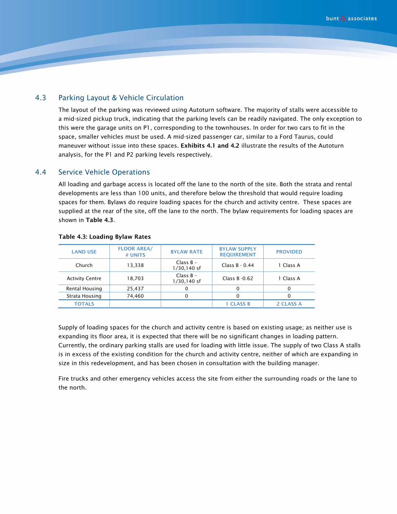
4.4 Service Vehicle Operations
All loading and garbage access is located off the lane to the north of the site. Both the strata and rental
developments are less than 100 units, and therefore below the threshold that would require loading
spaces for them. Bylaws do require loading spaces for the church and activity centre. These spaces are
supplied at the rear of the site, off the lane to the north. The bylaw requirements for loading spaces are
shown in Table 4.3.
Table 4.3: Loading Bylaw Rates
LAND USE FLOOR AREA/
# UNITS BYLAW RATE
BYLAW SUPPLY REQUIREMENT
PROVIDED
Church 13,338 Class B – 1/30,140 sf Class B - 0.44 1 Class A
Activity Centre 18,703 Class B – 1/30,140 sf Class B -0.62 1 Class A
Rental Housing 25,437 0 0 0
Strata Housing 74,460 0 0 0
TOTALS 1 CLASS B 2 CLASS A
Supply of loading spaces for the church and activity centre is based on existing usage; as neither use is
expanding its floor area, it is expected that there will be no significant changes in loading pattern.
Currently, the ordinary parking stalls are used for loading with little issue. The supply of two Class A stalls
is in excess of the existing condition for the church and activity centre, neither of which are expanding in
size in this redevelopment, and has been chosen in consultation with the building manager.
Fire trucks and other emergency vehicles access the site from either the surrounding roads or the lane to
the north.

N
[Issued for Discussion; not for Construction]
Ryerson Church Rezoning4826.07 December 2016 Scale 1:200 on Ledger Prepared by DL associates&
u n tb
Exhibit 4.1P1 Level Parking Layout Swept Path Analysis
S:\PRO
JECTS\B
P\4
826-0
7 R
yerson C
hurch
TA
MS\4
.0 A
nalysis &
Desig
n\2
0161208_4
826-0
7_P
ark
ing_La
yout_A
T_V
01.d
wg
2016/1
2/0
8 1
6:2
1, P
lotted b
y Dom
inic La
o

N
[Issued for Discussion; not for Construction]
Ryerson Church Rezoning4826.07 December 2016 Scale 1:200 on Ledger Prepared by DL associates&
u n tb
Exhibit 4.2P2 Level Parking Layout Swept Path Analysis
S:\PRO
JECTS\B
P\4
826-0
7 R
yerson C
hurch
TA
MS\4
.0 A
nalysis &
Desig
n\2
0161208_4
826-0
7_P
ark
ing_La
yout_A
T_V
01.d
wg
2016/1
2/0
8 1
6:2
2, P
lotted b
y Dom
inic La
o

5. TDM & ACTIVE MODES This redevelopment is relatively small, with little traffic being added to the area. Additionally, the
neighbourhood is already well positioned from a Transportation Demand Management (TDM) perspective.
Walking, cycling, and transit are well provided for locally, and the shops on West Boulevard and 41st
Avenue are close enough to be reached by active modes. As such, it is expected that the mode share for
transit and active modes will be high.
5.1.1 Walking & Cycling
Walking is a realistic form of travel for most people, especially over short distances with many people
willing to walk at least 5-minutes or 400m for short trips. Guidelines on the distances that people are
willing to walk to for various trip purposes are set out in Table 5.1. This table focuses on land uses that
can reasonably be accessed by walking from the site today.
Table 5.1: Walking Thresholds
FACILITY THRESHOLD DISTANCES
FACILITIES OR USES WITHIN THRESHOLD DISTANCES OF THE DEVELOPMENT
Bus/Transit 400m Buses on West Boulevard. Buses on 41st and 49th Avenues are only a little farther outside this radius
Schools 600-1200m Quilchena Elementary, Maple Grove Elementary, Magee Secondary, and Point Grey Secondary
Leisure Facilities 600-1200m Kerrisdale Community Centre, Vancouver Public Library Kerrisdale Branch,
Shops, restaurants, commercial 800-1200m Commercial uses along 41st Avenue and West Boulevard
Employment 2000m Commercial uses along 41st Avenue and West Boulevard
Sources: (a) TransLink (b) Institute of Highways and Transportation (UK)
The distance that a person is willing to walk is often related to the purpose of the journey, but is also
influenced by factors such as urban form, traffic, safety, personal fitness, car ownership, and parking
availability.
A person’s willingness to cycle is based on a number of lifestyle factors, including health benefits, cost
savings (compared to automobile use and parking) and convenience. Infrastructure also plays an
important role through the safety of routes, presence or absence of steep gradients, availability of cycle
storage facilities, etc. Cycling is a realistic transportation option for most people over short to medium
distances, i.e. up to 8 kilometres, or a 30-35 minute cycle.
Residents of this development will have cycle infrastructure at their doorstep; the Ridgeway Greenway runs
along 45th Avenue, and connects from Pacific Spirit Park to Burnaby’s Central Park.

5.1.2 Transit
When people are considering taking transit their decision is typically based on a number of factors
including their eligibility to drive, cost, convenience, relative journey times with other modes, personal
choice, income level, etc. Generally transit is a practical proposition for journeys of 4 kilometres and
more, however if high frequency service is available, it is also practical for shorter distance trips for
convenience.
Ryerson Church has Frequent Transit Network service along 41st Avenue, West Boulevard, and 49th Avenue,
making it well positioned for bus travel.
6. CONCLUSIONS & RECOMMENDATIONS
6.1 Conclusions
This document has outlined the transportation plan for the Ryerson Church redevelopment. Overall, the
redevelopment will have minimal impact on the surrounding community. We have reached the following
conclusions:
Traffic: The site will have minimal impact on the existing street network (CONFIRM WITH
COUNTS/ANALYSIS)
Parking: In our opinion, the parking provided for the residential uses is in line with the expected
demand for parking, based on unit size, tenure, and level of subsidy. The additional parking units
for the activity centre and church presents a significant improvement to the existing condition.
Cycling and Walking: the site is positioned on a major greenway. The area has good pedestrian
connectivity, with sidewalks on all streets. The site development supports this by providing bike
parking facilities.