rural settlement study -
TRANSCRIPT

Rural Settlement StudyTable of Contents
Introduction and Background 1
Future Land Use and Zoning 5
Future Land Use Amendments 19
Infrastructure and Services 23
Rural Character 29
Trends and IssuesUrban Service Area 35Sector Planning 36Annexation/Joint Planning Area Agreements 36Preservation Districts 37Western Beltway Part A 38Emergency Management 38
Recommendations 39
Bibliography 41
Appendices 43
A. Municipality Jurisdictions Map 45B. East Orange County Task Force Report--Executive Summary 46C. Vote of the Orange County Board of County Commissioners: 51
Extension of Utility Lines Across the Econlockhatchee RiverD. Future Land Use Maps--Rural Settlements 57E. Zoning Maps--Rural Settlements 63F. Future Land Use Element Policies Relating to Rural Settlements 69G. R-CE Cluster District (Section 38-551, Orange County Code) 75H. Excerpt of the Town of Hillsdale Proposed Rural Siting Guidelines 79I. Urban Service Area Amendments 91J. Wekiva River Protection Act 93
Orange County Planning Division, Physical Planning SectionJune 2000

This page intentionally left blank.

Introduction and BackgroundLong before Walt Disney came to Orange County, residents of Orange County sought the promise of life inFlorida by establishing small communities far from the city or town limits existing at the time. Residents madethis choice for a number of reasons, including availability or quality of land, relationships with other settlers,and the desire to live with minimum government intervention (Simmons 1951). These rural communitiesadded to the social, cultural, economic, and historical life in Orange County, and continue to do so today.
However, Orange County now looks very different than it did even ten years ago. In the past several years,Orange County’s population has grown from 677,491 in 1990 to an estimated 783,974 in 1997, an increaseof 15.7 percent (U.S. Bureau of the Census 1997). This growth has brought a need for new residentialdevelopment within the county to accommodate the influx of new residents. This growth accelerates pressuresfor rural land to be converted to urban uses.
At present, residents of Orange County who make the choice to live in rural communities find a differentlandscape than in past years. Suburban development patterns and central utility services are reaching theboundaries of several rural communities through municipal annexations. In addition, several rural areas haveresidential development at higher densities within or near their borders due to their proximity to employmentcenters. This residential development, in some cases built on a scale or with amenities not usually found inrural areas, alters the surroundings and the character of rural areas. These trends call into question thecontinued viability of rural areas in Orange County.
Orange County has made a number of efforts to preserve and protect rural communities in recognition of theirhistorical nature, existing development patterns, and community cohesiveness. Such efforts include thedesignation of Rural Settlements on the Future Land Use Map of the Orange County 1990-2010Comprehensive Policy Plan, the development of related future land use policies, protection of some RuralSettlements included in Joint Planning Area Agreements with municipalities, and creation of PreservationDistricts. In light of the degree of urbanization in Orange County, the question of whether rural areas aremerely areas waiting to be urbanized or are in need of preservation is important, as is the effectiveness ofcurrent initiatives for their preservation. As Orange County revises its Comprehensive Policy Plan to ahorizon year of 2020, this is an appropriate time to consider what Rural Settlement areas may become in thefuture.
1

Rural Settlements are communities within the County’s Rural Service Area that donot typically meet the adopted criteria in the Orange County 1990-2010Comprehensive Policy Plan (CPP) for low-density residential development basedon the lack of central utility services. Rural Settlements are outside of the County’sadopted Urban Service Area boundary, within which central utilities and otherurban services are available. Rural Settlements were first recognized and delineatedon the Future Land Use Map of the Orange County 1990-2010 ComprehensivePolicy Plan (CPP) in 1991.
The eighteen Rural Settlements currently designated in the CPP are Bridle Path,Bithlo, Christmas, Clarcona, Gotha, Lake Hart/Lake Whippoorwill, Lake MaryJane, North Apopka/Wekiva, North Christmas, Otter Lake, Paradise Heights,Sunflower Trail/Seaward Plantation, Tangerine, Tildenville, Wedgefield, WestWindermere, Zellwood, and Zellwood Station. Several of these settlements,including Christmas, Clarcona, Gotha, Tangerine, and Zellwood, have historicalcharacter and structures reflecting Orange County’s past. Other Rural Settlementsmirror the boundaries of platted subdivisions, such as Wedgefield and ParadiseHeights. A map of Rural Settlements in the County is included as Appendix A.
The relationship of Rural Settlements to other areas of the county has severaldefining characteristics. None of the Rural Settlements is an incorporatedmunicipality, although Bithlo was at one time incorporated. Thus, they competewith other areas of the county for Orange County government resources; theorganization of residents to accomplish this and other endeavors may vary. Moreover,Orange County’s degree of urbanization and the lack of incorporation of theseareas may limit eligibility for federal and state rural assistance funding. Finally,while rural areas in Orange County benefit from the provision of employment,goods, and services by municipalities in the County, their proximity also brings thepotential for encroachment and urbanization from urban areas expanding towardRural Settlement borders.
To provide context for analysis, Rural Settlements can be grouped into broadcategories based on their geographic location and, to some degree, commonconditions. Rural Settlements are grouped by region below:
North Bridle Path, North Apopka/Wekiva, Otter Lake,Tangerine, Zellwood, Zellwood Station
South Lake Hart/Lake Whippoorwill, Lake Mary Jane
East Bithlo, Christmas, North Christmas, SunflowerTrail/Seaward Plantation, Wedgefield
West Clarcona, Gotha, Paradise Heights, Tildenville,West Windermere
North Orange County Rural Settlements include Bridle Path, North Apopka/
Rural Settlements shallbe implemented to allow
residential uses in theRural Service Area whileprecluding development
in active agriculturalareas. The creation of
Rural Settlements recognizes the goal ofpreserving agricultural
and rural uses in OrangeCounty’s Rural Service
Area. Due to the urbanuses created by
numerous municipalannexations in the Rural
Service Area, OrangeCounty is constrained to
preserve these ruralareas by creating Rural
Settlements. [transitiondeleted]
Orange County CPPFuture Land Use Element
Objective 2.1
2
Although residents ofWedgefield have voicedsupport of development,particularly for shopping
and grocery stores,Citizens of Bithlo and
Christmas haveoverwhelmingly opposednew development, which
would impact theirdesired rural culture and
atmosphere!
William PonsEast Orange County Task
Force
Wekiva, Otter Lake, Tangerine, Zellwood, and Zellwood Station. Zellwood is a historic community; for moreinformation about the history of Zellwood and other Rural Settlements, please refer to the Future Land UseElement of the CPP. Zellwood Station’s boundaries were set by a Planned Development approved in 1973,to include 1,980 manufactured homes, a golf course, and commercial uses. The most recent assessment of thecommunity noted 943 homes had been developed (Miller Sellen Associates 1992).
Large-scale projects in the area may have an impact on Rural Settlements. In 1996, Orange County initiateda study of 44,000 acres of land in the northwest part of the county near Lake Apopka. This study providedthe basis of the Vision Northwest Plan (Plan), an area-wide master plan that addresses growth in a fashioncompatible with existing uses and future needs. As the Plan area incorporates Tangerine, Otter Lake, Zellwood,Zellwood Station, and parts of North Apopka/Wekiva, it has the potential to affect several Rural Settlementsin Orange County, if approved. In the nearer term, the Tiedtke Growth Center is a 969-acre project in NorthOrange County that has a development proposal under review by the County that includes 999 single-familyunits, 180,000 square feet of commercial uses, a golf course, parks, and an elementary school. The GrowthCenter concept, as defined in the Future Land Use Element of the Orange County Comprehensive Policy Plan,allows the establishment of Growth Centers in areas of the County adjoining urban development in otherjurisdictions where utility services may be obtained from these jurisdictions. One of two Growth Centers inthe County, with the other located at U.S. Highway 192 near Osceola County, the implementation of theTiedtke Growth Center recognizes growth occurs on a regional level irrespective of political boundaries, butalso may impact rural character in specific areas.
Another factor potentially altering Rural Settlements in the area is the annexation activity of the City of Apopka.Orange County has Joint Planning Area (JPA) agreements with many of the county’s municipalities to address,in part, mutual agreement on potential areas for municipal annexation. However, the County currently does nothave a JPA agreement with the City of Apopka. North Apopka/Wekiva is bordered by the City of Apopka onits southwestern border and has been partially annexed by the City of Apopka (see Appendix A). Other RuralSettlements in the area are further west of Apopka’s current borders, and the likelihood of annexation in thatregard is not known. Zellwood and Zellwood Station have Preservation District status, discussed later in thisreport, rendering annexation less likely in these areas. A Preservation District is under consideration forTangerine.
South Orange County Rural Settlements are Lake Hart/Lake Whippoorwill and Lake Mary Jane. Northand west of Lake Hart/Lake Whippoorwill, the City of Orlando has annexed or intends to annex several largetracts in proximity to Orlando International Airport. The City has developed a comprehensive master plan forthe area, the Southeast Sector Plan, which anticipates the development of several villages and commercialcenters using principles of traditional neighborhood design. Residential development is planned at a variety ofdensities based on a network of residential neighborhoods and centers, which range from no minimum densityto seven units per acre up to a maximum density of 25 to 50 units per acre (City of Orlando 1998). Bycomparison, the prevalent future land use of the Lake Hart/Lake Whippoorwill Rural Settlement is one unit pertwo acres.
In unincorporated Orange County, the Lake Hart Planned Development (PD) development approvals thatinclude 1,150 single-family units; 817 multifamily units; 261,000 square feet of commercial uses; an elementaryschool; and 1,000,000 square feet of industrial uses. Immediately north of Lake Hart, the Campus Crusadefor Christ project has development approvals for 600,000 square feet of office uses; 300 hotel rooms; and430 single-family and multifamily units on the site. The County currently is reviewing a proposal to expand thisproject to a total of 1,100,000 square feet of office uses, 150,000 square feet of retail uses, 1,450 hotel and
3

lodge/timeshare rooms, 250,000 square feet of industrial uses, 1,175 single-family units, 1,500 townhouse and apartment units, and other associated uses.The scale and uses of these projects, if approved and developed, may bring adifferent character to the area.
East Orange County Rural Settlements include Bithlo, Christmas, NorthChristmas, Sunflower Trail/Seaward Plantation, and Wedgefield. Two of thesecommunities, Bithlo and Christmas, have historic character. Bithlo was establishedin 1912 and incorporated in 1922; after years of decline, the town’s charter wasdissolved in the late 1970’s. Christmas was established as Fort Christmas duringthe Second Seminole War in 1835.
In 1998, former Orange County Chairman Linda Chapin made a policy statementrecommending that urban development should not take place east of theEconlockhatchee River. This was to highlight concern for the protection ofecologically-sensitive areas and prevention of urban sprawl in rural areas of thecounty. This policy underwent review by a local committee comprised of residents,business interests, environmentalists, and other interested parties. This committee,the East Orange County Task Force, prepared a report on several aspects ofdevelopment in the area ( see Appendix B). Based upon the findings of this taskforce, the Board of County Commissioners voted to extend utility capacity toBithlo, Christmas, and Wedgefield (see Appendix C for minutes relating to thisvote.
Another Rural Settlement in eastern Orange County, Sunflower Trail/SeawardPlantation, has seen land use changes in its vicinity that have brought or will bringdevelopment at urban densities. Sunflower Trail/Seaward Plantation has severallarge-scale Planned Developments (PD) in close proximity including the WaterfordTrails PD, the Spring Lake PD, and the Avalon Park DRI. These developmentshave approvals to construct over 4,500 single-family houses and 800 multifamilyunits, as well as other commercial and nonresidential uses.
West Orange County Rural Settlements experience growth pressures fromresidential development and municipal annexation; this group of Rural Settlementsincludes Clarcona, Gotha, North Apopka/Wekiva, Paradise Heights, Tildenville,and West Windermere. Clarcona and Paradise Heights are wedged between theCities of Apopka and Ocoee. Gotha is surrounded by the Cities of Orlando andOcoee and by the Town of Windermere. Tildenville is bordered by the City ofWinter Garden on three sides.
West Windermere is adjacent to the Town of Windermere and is near the city ofWinter Garden to the north. The name “West Windermere” is a misnomer, as theRural Settlement includes property on both the east and west sides of the Town ofWindermere, surrounding Lake Butler. Portions of West Windermere have beenincorporated into the Urban Service Area through CPP amendments. However,the densities have been limited on these parcels based on the requirements ofFuture Land Use Policy 4.1.26, which limits density to a maximum of two units
Many residents expressedthat the reason they are
living in the Bithlo andChristmas area NOW is toescape the congested andhighly regulated areas inthe central and westernparts of the county. Thegeneral expression wasthe desire to retain and
maintain the ruralcharacter and nature of
the area through verylimited or no further
development.
Robert GibbsEast Orange County Task
Force
4

5
per acre in a defined area of the Cypress Creek Drainage Basin.
Similar to North Orange County settlements, which are encompassed by or in proximity to Vision Northwest,West Orange County settlements may see future changes based upon sector planning activity in the area. Inwestern Orange County, the decline of the citrus industry and other factors led to interest in development toserve nearby tourist attractions, while utilizing a variety of land uses in an “urban village” design context.
In June 1995, the Orange County Board of County Commissioners incorporated the Village Land UseClassification into the CPP to accommodate the Horizon West sector plan, created by public-private planningpartnership for 38,000 acres in Orange County. The Horizon West area is projected to accommodate up to75,000 dwelling units in nine villages; specific areas plans have been adopted for two villages. The sector planarea abuts West Windermere and is southeast of Tildenville.
As outlined above, a number of issues and situations surround the Rural Settlements and have implications fortheir future viability. Through analysis of future land use, zoning, design, services, and trends and issues, thisstudy will describe conditions and make recommendations for Rural Settlement policies and activities.

This page intentionally left blank.
6

Future Land Use and ZoningIn a community, the future land use and zoning have an impact on physicaldevelopment and growth patterns. The future land use designations and zoningdistricts applied to land in Rural Settlements, as well as the changes made to theOrange County Comprehensive Policy Plan (CPP), are indicative of current growthtrends and potential areas of concern. Maps showing the future land usedesignations and zoning designations within Rural Settlements are included asAppendix D and E; a complete list of Future Land Use Element policies is givenin Appendix F.
Future Land Use Rural Settlement boundaries are delineated on the adoptedFuture Land Use Map of the CPP. Future Land Use (FLU) policies for Rural/Agricultural areas outside the Urban Service Area and Rural Settlement boundariesallow development at one dwelling unit per ten acres. Within Rural Settlements,FLU policies allow residential development to have the following designations:Rural Settlement 1/1 (1 dwelling unit per acre), Rural Settlement 1/ 2 (1 dwellingunit per two acres), and Rural Settlement 1/5 (1 dwelling unit per five acres). Incertain cases, two dwelling units per acre are allowed where Rural Settlementland abuts higher density uses in a municipality, to provide a buffer for suchdevelopment (FLU Policy 2.1.17; added June 1994 by Ordinance #94-13). Insome cases, existing Rural Settlements have higher densities and nonresidentialland uses based on preexisting uses or zoning.
Future land use designations in place in the Rural Settlements vary. In northwestOrange County, Bridle Path is designated Rural Settlement 1/2. North Apopka/Wekiva has Low Density Residential, Rural Settlement 1/2, and Rural Settlement1/5 areas, but is mostly Rural Settlement 1/1, with a few Commercially-designatedparcels. Also, a section of North Apopka/Wekiva has been annexed by the Cityof Apopka, and the City’s future land use designations have been applied to thisarea. Tangerine and Otter Lake are mostly Rural Settlement 1/1, with some LowDensity Residential and several Commercially-designated areas with frontage onU.S. Highway 441. Zellwood Station residential areas are all designated LowDensity Residential; several Commercial and Institutional parcels have frontageon U.S. Highway 441. Zellwood has residential areas designated Low DensityResidential and Rural Settlement 1/1, with relatively large areas with Industrialand Commercial designations on U.S. Highway 441.
In south Orange County, Lake Hart/Lake Whippoorwill are all designated RuralSettlement 1/2 , with the exception of a Commercially-designated area alongNarcoossee Road. Lake Mary Jane is designated Rural Settlement 1/1 to thenorth and Low Density Residential to the south, with a few Commercial areasalong Lake Mary Jane Road.
To the east, Bithlo has residential designation of Low Density and Rural Settlement1/1, with a large corridor designated Commercial along East State Road 50.Christmas is designated Rural Settlement 1/1, except for parcels designatedCommercial along East State Road 50. North Christmas is entirely designated
Large lot development isimportant in the RuralService Area to ensureurban development is notprecluded. The lotsmust be large enough toprovide for resubdivisionat urban densities.
Orange County CPPPotable Water Element
It is not the County’sintent to preserve allagricultural lands inperpetuity. The intent,however, is to maintainrural lands untiladequate levels ofservices and facilities areavailable toaccommodate urbandevelopment.
Orange County CPPFuture Land Use Element
7

Rural Settlement 1/5. Sunflower Trail/Seaward Plantation is designated RuralSettlement 1/1 to the north, but most of its acreage is designated Rural Settlement1/2, with the exception of Low Density Residential land to the east and a fewCommercially-designated parcels with frontage on East State Road 50. Wedgefieldhas land designated Low Density Residential, a golf course designated Parks/Recreation, cluster lots designated Low-Medium Density Residential, and someparcels designated Commercial along State Road 520.
In west Orange County, Gotha is predominantly designated Rural Settlement 1/1,with one section designated Low Density Residential and a few parcels designatedCommercial at the intersection of Gotha Road and Hempel Avenue. WestWindermere is entirely designated Rural Settlement 1/1, except for areas designatedVillage on the fringe of Horizon West. Tildenville is designated Low DensityResidential with a few Commercial and Institutional parcels. Paradise Heightshas Low-Density Residential future land use and several Commercial parcels.Finally, Clarcona has a lot of diversity in its future land use, with Rural Settlement1/1, Rural Settlement 1/2, Rural Settlement 1/2, Low Density Residential,Institutional, Commercial, and Parks and Recreation all represented.
The issue of the appropriate densities for the County’s rural areas has manydimensions. The development community points to the 1 dwelling unit per ten-acre density as a cause of urban sprawl. Specific concerns expressed are thatthis density forces higher-density development to “leapfrog” to adjacent counties,excludes areas from the county’s transportation, utilities, and economic developmentplanning, and constrains “financial opportunities and land values” (Miller-SellenAssociates, Inc. 1995). From the County’s perspective, the Future Land UseElement recommends the 1 dwelling unit per 10 acre standard as a means toavoid the permitting of subdivisions in agricultural areas and land speculation onthe part of agricultural landowners (Orange County 1991). This area is considereda holding category until the appropriate time, if any, for urban uses.
Within Rural Settlement areas, higher densities than the 1 dwelling unit to ten acrestandard are permitted based upon the County’s recognition of these areas ashistoric areas of settlement and, in some cases, the presence of services to supporta slightly higher, but still rural density. However, additional Low and Low-MediumDensity Residential future land uses are allowed to promote the development ofaffordable housing projects (FLU Policy 2.1.10; amended June, 1994, Ord. #94-13). An example of how this policy has been used is the Waterford Trails PlannedDevelopment (PD), formerly known as Colonial/Sunflower. This project’s northernboundary is East State Road 50 and extends east to Old Cheney Highway,incorporating sixty acres of land in Sunflower Trail/Seaward Plantation as Low-Density Residential for affordable housing.
The cost of land in Rural Settlements promotes the development of affordablehousing, and the availability of mobile homes provides additional
....additional landdesignated Low and Low-
Medium DensityResidential shall not be
permitted in RuralSettlements except for
County certifiedaffordable housing
projects and as providedin Future Land Use Policy2.1.17. Future Land Use
Map amendments forCounty certified
affordable housingprojects shall only be
supported when a linkageof affordable housing and
need within theSettlement is
demonstrated. All otheramendments to
residential densities ofthe Rural Settlement shall
not allow residentialdevelopment to exceed
one (1) dwelling unit peracre.
Future Land Use Policy2.1.10
The permitted densitiesand intensities of land use
within the RuralSettlements shallmaintain the rural
character.
Future Land Use Policy2.1.8
8

Mobile homes in Sunflower Trail
housing options. While affordable housing is promoted with density incentives in the FLU Element, the lack ofcentral water and sewer services to accommodate density renders the policy inconsistent with other FLUpolicies intended to preserve traditional rural densities. This inconsistency is not reconciled in current policies,nor is the inconsistency of choices made to extend or not to extend services to particular areas, such as theCypress Lakes Planned Development in east Orange County, which was a condition of approval prior to theadoption of the Orange County 1990-2010 Comprehensive Policy Plan (CPP) in 1991.
As such, FLU Policy 2.1.10 should be revised to reinforce the need for available infrastructure beforeincreasing density in Rural Settlements. Revisions should also provide clear policy criteria that facilitatesdecisions regarding infrastructure provision. Criteria should be similar to the that provided in FLU Policy1.1.5.1, which prioritizes the importance of Urban Service Area expansions based on design factors, economicdevelopment potential, and sector planning. Finally, the degree to which the promotion of affordable housingin Rural Settlements impacts the provision of services and rural character and the need for this housing to serverural residents require further analysis.
Another issue of concern is the creation of new Rural Settlements. Objective 2.1 of the FLU Element notes“the creation of Rural Settlements recognizes the goal of preserving rural and agricultural uses in OrangeCounty,” and several policies in the FLU Element reference the creation or expansion of Rural Settlements.Criteria for creation and expansion of Rural Settlements is found in Policies 2.1.3 through 2.1.3 of the FutureLand Use Element. Rural Settlements may be expanded or created as amendments to the comprehensiveplan. However, projects must demonstrate a need for additional land to accommodate twenty year populationand employment projections through use of a small area study. Projects must also maintain the rural characterof the area, and expansions must be at least 25 percent contiguous to an existing Rural Settlement. New RuralSettlements must be a minimum of twenty acres and approved as Planned Developments if in excess of 100acres.
These policies were used to implement the Rural Settlement concept at the time of plan adoption. However,a number of applications to alter boundaries of Rural Settlements have been submitted since these policies
9

...where the homes werevery similar in size and
original sales price…theappreciation was 12.7percent greater in the
open space subdivision,where homes rose$17,100 more, on
average, by the end ofthe 21-year study period.It seem clear that people
are willing to pay moremoney for equivalent
homes on smaller lotswhen other amenities are
provided in theneighborhood.
Randall ArendtRural By Design:
Maintaining Small TownCharacter
were adopted in 1991. These applications, in general, would develop housing athigher densities than permitted in the Rural Service Area of the county. As such,they are not consistent with the County’s Development Framework, as they diminishthe use of the adopted Urban Service Area boundary (discussed in further detaillater in this report) as a growth management mechanism. Also, the rationale forcontinuing to provide for the creation of new Settlements is less clear, especiallygiven the presence of vacant parcels within adopted Rural Settlement boundaries.
There are 4,109 vacant parcels within the boundaries of Rural Settlements (OrangeCounty Planning Department 2000). Over 2,700 are less than one acre in sizeand may require vested rights or parcel assembly for development. However,almost 175 parcels are greater than ten acres in size, potentially allowing for thedevelopment of housrural subdivisions consistent with the Rural Settlement concept.
Given the availability of vacant land, the creation of new settlements hinders theabsorption of vacant land to facilitate growth in a compact, responsible fashion.Also, changes to the Urban Service Area boundary over the past several yearshave expanded the fringe of urbanization toward rural areas. As this expansiontakes place, having mechanisms to allow various other densities through RuralSettlements promotes a fragmented land use pattern. Policies to allow creation ofRural Settlements were established to recognize settlement that had already takenplace by 1991. For these reasons, FLU Policy 2.1.5 and sections of FLU Policy2.1.4 that allow the creation of new Rural Settlements should be modified toreinforce the County’s sound growth management policies.
To address another potential refinement to Rural Settlement policies, FLU Policy2.1.6 requires development proposals of over 100 acres within a Rural Settlementto have final approval as a Planned Development (PD) with performance standardsdesigned to protect rural character. The processing of more development proposalsas PDs would improve the ability of the county to preserve rural character, due toreview by a broader cross-section of county agencies and the additional performancestandards required of PDs. Review would be facilitated if initiatives are put inplace to detail the means to accomplish this preservation, such as an overlay district.This guidance is important to ensure that urban standards are not applied to thisprocess to create a product more urban than rural.
In addition, the processing of more projects as PDs will provide rural residents theopen space granted to residents of PDs in urban areas. The Land DevelopmentCode requires PDs to provide “both active and passive recreation areas at theratio of 2.5 acres per one thousand projected population”, with population calculatedat 3.1 persons per single-family unit and 2.1 persons per multifamily unit (Section1253, Orange County Code). PDs also must provide open space of varioustypes, such as greenbelts, ponds, and buffer zones, at ratios ranging from 10 to25 percent of the development area, based on the type of development.
As well as preserving rural character and open space, the encouragement of PDsin Rural Settlements would provide needed recreation opportunities to some rural
10

residents, as discussed in the Infrastructure and Services section of this report; privately-provided recreationalamenities are usually limited by the covenants, conditions, and restrictions of the development to use by residentsonly. Also, preservation of open space provides visual, as well as recreational, benefits and may facilitate thepreservation of rural character in these areas. For these reasons, it is recommended that the threshold forconsideration of development proposals as Planned Developments be lowered from 100 acres by revisingFLU Policy 2.1.6.
To provide context in the consideration of the appropriate policies for and land uses in Rural Settlements,citizen input must be incorporated in the decisionmaking process. Community meetings and visioning processeshave demonstrated that little consensus exists to date in several Rural Settlements regarding preferreddevelopment alternatives. Constituencies in Orange County’s rural areas may include:
� Large landowners, perhaps former farmers, ranchers, and citrus growers, who want the maximum economicbenefit from a land sale;
� Owners whose families have lived in the same area or the same home for generations and who have ahistorical connection to the community;
� Owners who keep horses, goats, or livestock or have a greenhouse or small-scale agricultural business;� Owners who have moved to rural areas to escape urban densities and traffic, but who desire some urban
amenities, such as shopping and street paving; or� Owners who have moved to rural areas to escape urban densities and traffic and who want to preserve the
area exactly as they found it.
Based on their diversity and what they see as their best interest, these constituencies have needs and concernswhich may conflict. Planning activities in Orange County’s rural areas have incorporated public participation,notably in the Vision Northwest planning process and in the formation of the East Orange County Task Force(summary included as Appendix B). The Orange County Evaluation and Appraisal Report (EAR) of theOrange County 1990-2010 Comprehensive Policy Plan (CPP), which assessed the goals, objectives, andpolicies of the CPP, also included a number of public participation initiatives. As part of the EAR-based CPPamendment cycle, efforts targeted at Rural Settlement residents should be initiated to provide input for revisionsto Rural Settlement boundaries or policies through proposed amendments. Not only would these effortsreflect the County’s tradition of and commitment to public participation, it would provide valuable local insightinto potential policy creation and revision. Staff recommends targeted efforts to solicit this information, whichcould potentially include community meetings, World Wide Web pages, and other means described in theCounty’s Public Participation Handbook.
While additional information is solicited from Rural Settlement residents, the following consideration of thevarious land uses is a starting point for discussion. In terms of residential uses, the 1991 CPP asserted that a“large demand for one and two acre residential lots exists in Orange County”, to some degree based on thefact that “in the last five years, more than 2600 acres have been rezoned ….for one acre lot size residentialdevelopment” (Orange County 1991). As described previously, Rural Settlements have future land usedesignations that accommodate these densities. Also, several Rural Settlements contain vacant land zoned forthese densities. To illustrate, the Tangerine Rural Settlement contains at least 271 acres of undeveloped landzoned Rural-Country Estate (R-CE), which permits up to one dwelling unit per acre, and the Otter Lake RuralSettlement has close to 79 acres of undeveloped land zoned R-CE (Orange County Planning Department1998).
In the years since CPP adoption in 1991, the popularity of the small-lot subdivision has increased, as documented
11

in the EAR. While urban land is divided at these densities to benefit from marketdemand, alternatives to smaller lots may be found closer to the urban fringe tobenefit from reduced land prices. As documented in the Future Land UseAmendments section of this report, amendments have incorporated rural propertyinto Rural Settlements and redesignated Rural Settlement property at urbandensities.
Diverse residential densities to support market preference, agricultural activity,and other factors are critical for preservation of rural lifestyles. The viability ofadopted boundaries of Rural Settlements should be evaluated given these concernsand the future land use changes in the years since 1991. Given incrementalmodifications over the years, an evaluation of the adopted boundaries, informedby public participation by residents, would best suit the evolution of RuralSettlements in coming years.
For commercial uses, the availability or proximity to utility services controls thelevel and type of development activity. The commercial and office uses permittedin Rural Settlements are those serving the neighborhood with retail and personalservices, as defined in several FLU policies. These policies, including FLU Policy2.1.14 (sidebar), provide guidance to ensure commercial uses are neighborhoodserving and scaled appropriately for the community. Given these concerns, staffrecommends the policy be revised to strengthen the intent of the policy and ensurethat sufficient resident demand exists for proposed commercial uses.
Consistent with adopted FLU policies, many of the commercial uses found inRural Settlements are small retail operations, such as convenience stores.Exceptions are found in Bithlo, Zellwood, and other Rural Settlements, with more
Industrial uses in theRural Service Area shall
be permitted only asshown on the Future LandUse map within the Rural
Settlements of Bithlo,Christmas, and Zellwood.
Approval of suchindustrial uses shall be
conditioned upon soilsuitability for use of septic
tanks and shall becontingent upon the
provision of adequate fireflows. ... Further
industrial designationsshall be prohibited from
all Rural Settlementsincluding Bithlo,
Christmas, and Zellwood.
Future Land Use Policy2.1.13
Commercial uses in RuralSettlements shall not
exceed the neighborhoodlevel and shall be
developed according tothe following criteria:
A. These uses shall belocated to serve the
residents of the ruralarea and not primarily to
attract “pass-by” trips;and,
B. These uses shallcontain retail andpersonal services
intended to serve theimmediate population.
Future Land Use Policy2.1.14
12
An automobile-related business in Bithlo, characteristic of the area
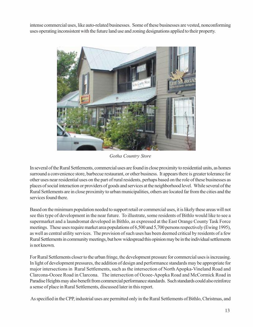
intense commercial uses, like auto-related businesses. Some of these businesses are vested, nonconforminguses operating inconsistent with the future land use and zoning designations applied to their property.
Gotha Country Store
In several of the Rural Settlements, commercial uses are found in close proximity to residential units, as homessurround a convenience store, barbecue restaurant, or other business. It appears there is greater tolerance forother uses near residential uses on the part of rural residents, perhaps based on the role of these businesses asplaces of social interaction or providers of goods and services at the neighborhood level. While several of theRural Settlements are in close proximity to urban municipalities, others are located far from the cities and theservices found there.
Based on the minimum population needed to support retail or commercial uses, it is likely these areas will notsee this type of development in the near future. To illustrate, some residents of Bithlo would like to see asupermarket and a laundromat developed in Bithlo, as expressed at the East Orange County Task Forcemeetings. These uses require market area populations of 6,500 and 5,700 persons respectively (Ewing 1995),as well as central utility services. The provision of such uses has been deemed critical by residents of a fewRural Settlements in community meetings, but how widespread this opinion may be in the individual settlementsis not known.
For Rural Settlements closer to the urban fringe, the development pressure for commercial uses is increasing.In light of development pressures, the addition of design and performance standards may be appropriate formajor intersections in Rural Settlements, such as the intersection of North Apopka-Vineland Road andClarcona-Ocoee Road in Clarcona. The intersection of Ocoee-Apopka Road and McCormick Road inParadise Heights may also benefit from commercial performance standards. Such standards could also reinforcea sense of place in Rural Settlements, discussed later in this report.
As specified in the CPP, industrial uses are permitted only in the Rural Settlements of Bithlo, Christmas, and
13
Zellwood, in order to “grandfather” existing uses at the time of adoption. PerFLU Policy 2.1.13, no new industrial uses are permitted in any Rural Settlement.The primary reason for this limitation is the lack of central utility services in theseareas. The rationale for this policy may also have been an attempt to limit intenseuses, such as extractive industries, from small Rural Settlement communities. Asclarification to this policy, Industrial future land use and zoning districts are foundonly in Zellwood at this time.
Since the adoption of the CPP in 1991, commercial zoning districts have undergonerevisions that have restricted production activities to industrial zoning districts.This change limits the new business activities possible in Rural Settlements underthis policy, as activities formerly possible in Commercial designations would requirean Industrial designation. However, existing businesses are not restricted in theiroperations.
Notwithstanding the prohibition on new industrial future land use designations inFuture Land Use Policy 2.1.13, additional industrial uses were proposed in theZellwood Development District initiative based on master planning for the area.The District would have had central water and sewer service under this proposedpolicy, as well as master planning to promote compatibility. No other changes inindustrial use policies for Rural Settlement areas recently have been proposed,and none are recommended at this time.
Zoning A number of different zoning districts are found in the various RuralSettlements, which will be described in a general sense. For more specificinformation, please refer to zoning maps included as Appendix D. In north OrangeCounty, Bridle Path is designated Planned Development. Tangerine is mostlydesignated R-CE (Rural Country Estate), with other parcels having residential,commercial, or agricultural zoning. Otter Lake has residential and agriculturalzoning, with a few commercially-designated parcels. Zellwood has propertydesignated mostly with residential and industrial zoning districts, with acommercially-designated corridor along U.S. Highway 441. Zellwood Station isentirely designated Planned Development or A-1 (Citrus Rural District). Finally,North Apopka/Wekiva is designated agriculturally or residentially, with the exceptionof property zoned Planned Development and other property zoned with the Cityof Apopka’s zoning districts.
In south Orange County, Lake Hart/Lake Whippoorwill mostly has A-2 (FarmlandRural District) and R-CE (Rural Country Estate), with a few commercially-designated parcels. Lake Mary Jane has residential, agricultural, commercial, andPlanned Development zoning.
In east Orange County, Sunflower Trail is mostly designated A-2 (Farmland RuralDistrict), with some Planned Development and R-T-2 (combination mobile homeand single-family dwelling district). Bithlo has diverse zoning districts, but is mainlydesignated residentially and with the Planned Development districts. NorthChristmas is designated R-CE-5 (minimum 5-acre lots). Christmas is mostly
In an attempt to preserverural character, townshave resorted to two-,three-, four-, and five-
acre zoning. As a result,more land gets bulldozed
and more road must bebuilt for each house,
people have more yardthan they know what to
do with, and land andhouse prices go through
the roof. Large-lot zoninghas done little or nothing
to preserve the landbecause it has occurred
in the conventional zoningcontext: uniform
development of the entirelandscape.
Joel Russell“The Need for New
Models of Rural Zoning”
For many people thedream of owning rural
acreage turns into anightmare as they
discover theirenslavement to
maintaining large piecesof land. Even a two-acrehouselot, if not wooded,is “too large to mow and
too small to plow”. ...Theoft-expressed desire “tolook out my window and
not see my neighbor’shouse” reflects a
psychological need that issometimes better
satisfied with creative sitedesign and smaller lots.
Randall ArendtRural By Design:
Maintaining Small TownCharacter
14
designated A-2 (Farmland Rural District), with several commercially-designated parcels along East ColonialDrive. Finally, Wedgefield has a mix of commercial, residential, and agricultural designations.
In west Orange County, Paradise Heights and Clarcona have residential, commercial, and agricultural zoningdistricts; Clarcona has the Planned Development district, as well. Gotha has residential and agricultural zoning,with a few parcels designated with commercial or Planned Development districts. West Windermere has mostlyPlanned Development or R-CE (Rural Country Estate) zoning, with a few exceptions.
The CPP recommends creating a zoning district overlay for Rural Settlements designed to preserve characterand a “sense of place”. The CPP noted this district, at a minimum, should ensure road design and improvementwill have limited impact on the natural and historical environment, with narrow pavement, alternative transportationaccess, and appropriate landscaping. Also, the CPP specified that new construction should not cause “substantialmodification to the topography and natural resources” (FLU Policy 2.1.7). In addition, the Future Land UseElement of the CPP recommended zoning changes and the creation of a special district, which was evaluatedbut never implemented. This was due, in part, to the concern of property owners that allowable uses may berestricted. The Evaluation and Appraisal Report of the CPP does not recommend any changes to specificFuture Land Use Element policies.
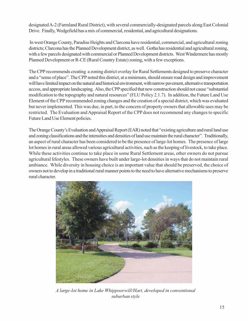
The Orange County’s Evaluation and Appraisal Report (EAR) noted that “existing agriculture and rural land useand zoning classifications and the intensities and densities of land use maintain the rural character”. Traditionally,an aspect of rural character has been considered to be the presence of large-lot homes. The presence of largelot homes in rural areas allowed various agricultural activities, such as the keeping of livestock, to take place.While these activities continue to take place in some Rural Settlement areas, other owners do not pursueagricultural lifestyles. These owners have built under large-lot densities in ways that do not maintain ruralambiance. While diversity in housing choice is an important value that should be preserved, the choice ofowners not to develop in a traditional rural manner points to the need to have alternative mechanisms to preserverural character.
15
A large-lot home in Lake Whippoorwill/Hart, developed in conventionalsuburban style

16
Preservation of rural character has, in part, been implemented in Orange County using the R-CE (RuralCountry Estate) Cluster District, which requires the clustering of units to preserve open space. The minimumtract size within the district is twenty acres, with densities not to exceed one dwelling unit per acre; the minimumlot size is one-half acre, with a minimum lot width of 100 feet. Maximum lot coverage is 60 percent of landarea. Sections of the Orange County Code relating to R-CE-Cluster District are included as Appendix G.
Naturally, the RCE-Cluster zoning option is only as effective as its implementation. Rezoning to R-CE-ClusterDistrict is requested at the rate of five to six applications per year for property located in all parts of theCounty. Implementation is apparently not constrained by the development community, who view this optionas a means of “planning around” development constraints on a site, such as wetlands. However, many neighboringresidents express concerns during community meetings relating to the perceived effect of smaller lots in thevicinity of their property on their property’s value and their perception that undeveloped areas on a proposedplan will not remain undeveloped. Although several studies demonstrate that property values increase at agreater rate in developments with open space amenities than those lacking such amenities, this is not a factorunder consideration by residents.
As discussed in this analysis, the lowering of the 100-acre threshold for projects in Rural Settlements to beconsidered Planned Developments would have several benefits, which include the flexibility to have more sitespecific project design and clustering of units. It is important to note any additional use of clustering shouldreflect rural character and standards and not urban or suburban design sensibilities. An example of ruralclustering design standards is included as Appendix H.
Other mechanisms could be assessed as to their benefit to Rural Settlement areas. The CPP recommends thatthe Land Development Code be amended to include criteria to ensure the “scale, and density and/or intensityof development within the Rural Service Area promotes the intended rural character. The regulations mayinclude, but should not be limited to, height limitations and buffer requirements” (FLU Policy 2.3.1) as part ofa overlay district , as mentioned previously.
The implementation of a zoning overlay district could focus on the major intersections or commercial areasrecommended for additional standards, similar to the intersection of Gotha Road and Hempel Avenue. Azoning district overlay applied to these areas could also protect scenic roadway corridors found abutting manyof these intersections, including along Hempel Avenue and Clarcona-Ocoee Road. The logic of these protectionsand the experience of Seminole County are discussed in the Design and a Sense of Place section of this report.Implementation of an overlay district on a test basis in selected Rural Settlement areas, based in part on staffassessment and resident support, will help to preserve the rural character of these areas.

17
A scenic corridor along Lake Mary Jane Road

This page intentionally left blank.
18

Future Land Use AmendmentsIn the years since the Rural Settlement concept was implemented, development proposals continue to bereceived from the private sector for property within Rural Settlements. Proposals generally request a transitionfor Rural Service Area land to higher density Rural Settlement future land use categories or the redesignationof property in Rural Settlements to allow urban densities. The boundaries of several Rural Settlements, includingBithlo, West Windermere, and Gotha, have changed as a result of approved future land use amendments.
As indicated earlier, Rural Settlements may be expanded or created as amendments to the Orange County1990-2010 Comprehensive Policy Plan (CPP) for projects that address a demonstrated need for additionalland to accommodate twenty year population and employment projections. Amendment applications mustinclude a small area study that demonstrates need for the land use change. Expansions must be at least 25percent contiguous to an existing Rural Settlement. New Rural Settlements must be a minimum of twenty acresand must be approved as Planned Developments if the proposal exceed 100 acres. Criteria for creation andexpansion of Rural Settlements are found in Policies 2.1.3 through 2.1.6 of the Future Land Use Element.
After the adoption of the Orange County CPP, subsequent amendment cycles have had varying effects on thesize, integrity, and character of the Rural Settlements. A table that lists all USA amendments is found inAppendix H. The table is useful in noting areas with Rural future land use designations altered by changes tothe Urban Service Area (USA) boundary, in order to assess conversions from rural to urban land. The USAboundary is delineated in Appendix A.
In 1992, a proposal was submitted to create a new Rural Settlement on 280 acres west of Rock Springs Roadand south of Kelly Park Road. In 1993, Comprehensive Policy Plan changes affecting Rural Settlements weremade for development in Clarcona and Bithlo. Clarcona had 9.3 acres changed to a Commercial future landuse designation for the development of commercial areas to serve neighborhoods. In addition, Bithlo wasexpanded by 287.48 acres (190.05 developable) for the provision of affordable housing and neighborhoodcommercial uses with central utility services.
In 1994, two USA amendments were approved that affected Rural Settlements. Acreage (246.10 acres/198.00 developable) was removed from West Windermere in the Four Corners area near the intersection ofConroy-Windermere Road and Apopka-Vineland Road and given the Community Village Center land usedesignation. Also, 50 developable acres were removed from Sunflower Trail.
In addition, two expansions of Rural Settlements were approved in 1994. In West Windermere, approximatelyeleven acres were added to West Windermere for residential development. Approximately 9.74 acres wereadded to the Gotha with a designation of 1 DU/acre. In other activity, Bithlo had 14.43 acres designated asLow Density Residential for the provision of affordable housing by Orange County Habitat for Humanity.
In 1995, several future land use amendments altered various Rural Settlements. A future land use amendmentadded 58 acres to West Windermere. Three amendments expanded the USA by a combined 392.60 acres(380.40 developable) to accommodate the Four Corners development by redesignating property from WestWindermere. Another amendment changed Rural Settlement 1/1 to Rural Settlement Low Density (2 dwellingunits per acre) for 38.17 acres in Gotha to serve as a buffer between Gotha and Ocoee. The parcels had beenthe subject of a contested annexation by the City of Ocoee. In Gotha, 93.7 acres were added to the RuralSettlement to accommodate property owners’ request to be in the Gotha Preservation District.
19

Land use changes also were approved for 14.5 acres outside Bithlo. Land use was changed from Agriculturalto Commercial for the development of additional neighborhood commercial services to support the CornerLake Planned Development. Also in Bithlo, 27.82 acres were designated Commercial/ Low Density Residential.In total, the USA was expanded by 1,156.9 acres (808.10 developable) by the above-referenced amendmentsand others (See Appendix I). Later that year, the Campus Crusade for Christ Development of RegionalImpact expanded the USA by an additional 285 acres (175 developable).
In 1996, West Windermere expanded by 21.27 acres designated Rural Settlement 1/1. Also in west OrangeCounty, the USA was expanded by 209 acres (198 developable) near the Horizon West Study Area toaccommodate a Planned Development of single-family and multifamily residential, hotel, and commercial uses.
In northwest Orange County, the future land use was changed to Growth Center for approximately 968 acres(918.30 developable) south of Tangerine for a Planned Development. The change, which included a sectionof Tangerine, was made to accommodate a Planned Development comprised of residential, commercial,open space, and educational uses. The area is now known as the Tiedtke Growth Center.
In east Orange County, two future land use changes were made in the vicinity of Sunflower Trail. The USAwas expanded by 600 acres (570 developable) and given Low-Density Residential Future Land Use for theEidson Trust property, now known as the Sunflower Trail Estates Planned Development. Also, the USA wasexpanded by approximately 400 acres (298.2 developable) south of Sunflower Trail for the Spring LakePlanned Development. The two Planned Developments are immediately adjacent to each other.
Other changes in east Orange County were seen that year, as Bithlo was expanded by 2.5 acres to accommodatecommercial development as a Planned Development. A new Future Land Use Element Policy (2.2.7) permittedresidential development at urban densities (up to four DU/acre) in Rural Settlements, if the property is at leastthirty-five percent contiguous to higher density or intensity urban development in an adjacent municipality. Theintention of the policy was to allow transitional uses between densities; the policy’s immediate result was tocreate an exception to the USA of 455.68 acres (366 developable) to encompass the Belmere PlannedDevelopment, which abuts the Cities of Winter Garden and Ocoee on two sides.
In 1997, the most significant future land use change was 5,194.00 acres (3238.00 developable) for thedevelopment of the Horizon West/Lakeside Village concept. This change in west Orange County, includingland formerly in the Rural Service Area and a portion of West Windermere, was the result of a major planningeffort discussed in greater detail later in this report. Also in west Orange County, fifty acres in Gotha weregiven Rural Settlement Low Density (maximum of two DU/acre) future land use as a transitional district toaccommodate a Planned Development. Also, a 7.53 acre parcel in Gotha was also given the Rural SettlementLow Density use. Finally, the future land use designation for 67 acres in Clarcona was changed from RuralSettlement 1/5 to Rural Settlement 1/1, and an additional five acres in Clarcona were changed from RuralSettlement 1/1to Rural Settlement Low Density future land use.
In 1999, several applications proposed changes to or creation of Rural Settlements. Ten acres were added toClarcona for the relocation of a family homestead to be displaced by the Apopka Bypass expresswayconstruction. In West Windermere, eighty acres were added to the USA immediately south of Gotha fordevelopment at two homes per acre. Fourteen acres were added to Tangerine and designated Rural Settlement1/1. A new Rural Settlement, Bridle Path, was approved through the designation of 71 acres as Rural Settlement1/2.
20

Also, several applications were made in 1999, but later withdrawn, that are reflective of trends affecting RuralSettlements. An applicant proposed the removal of 36 acres from Tangerine to add to the Tiedtke GrowthCenter for the development of commercial and low-density residential uses. Another application proposedthe creation of a new Rural Settlement, comprised of 180 acres in northwest Orange County, for developmentat a density of one dwelling unit to two acres. On a larger scale, the staff-initiated amendment to create theZellwood Development District was transmitted to the Florida Department of Community Affairs to addapproximately 845 acres to the Zellwood Rural Settlement to address the impacts of the lake Apopka muckfarm purchase.
In the first amendment cycle of the year 2000, two applications were approved that altered Rural Settlementboundaries. One application added 30 acres to West Windermere near Horizon West for designation as RuralSettlement 1/1. The other application removed 42 acres from Gotha for designation as Low Density Residential.The second amendment cycle of the year 2000 will begin in August 2000.
Over the past several years, it can be seen that a number of changes have affected the County’s Rural Settlements,and that some Rural Settlements have been altered more than others, due to market demand, large-scaleplanning initiatives, and the requests of property owners. In addition, policies adopted in 1994 regardingincreased density for affordable housing developments and land abutting higher-density development inmunicipalities have altered Bithlo and Gotha. With the exception of these policies, no policies have been addedto or deleted from the Future Land Use Element to further the Element’s objective of preserving agriculturaland rural uses in the Rural Service Area. The means of approaching this task in light of current conditions issuggested in the Recommendations section of this report.
21

22
This page intentionally left blank.

Infrastructure and ServicesThe presence of infrastructure and services in this section is primarily considered for their relationship to densityand development patterns. Based on the number of Rural Settlements and the intended scope of this analysis,discussion of infrastructure and services will be general and not reference specific locations or providers. Thisanalysis also refrains from discussion of some types of community services, including law enforcement, fire andemergency medical services, schools, and libraries, in favor of services directly addressed by the OrangeCounty 1990-2010 CPP. Government facilities and services are defined by the Capital Improvements Elementof the CPP as traffic circulation, mass transit, parks and recreation, potable water, solid waste, and stormwatermanagement, in accordance with the State of Florida’s 1985 Growth Management Act (Orange County PlanningDepartment, 1998). These services have adopted level of service (LOS) standards included in the CPP andare discussed below.
Traffic Circulation Orange County’s adopted level of service on state and county roadways ranges fromlevel of service “C” of freeways and principal arterials located in rural areas to level of service “E” on minorarterials and collectors located in urban areas (Orange County 1998). Several roadway segments locatedwithin or near Rural Settlements are operating below the adopted LOS. Examples include Apopka-VinelandRoad from Winter-Garden Vineland Road to Darlene Drive and from Conroy Windermere Road to GothaRoad; Colonial Drive from Alafaya Trail to Lake Pickett Road; U.S. 441 from Overland Road to PiedmontWekiva Road; Silver Star Road from Good Homes Road to Hiawassee Road. All segments have an adoptedLOS of D or E and are operating at LOS F (Orange County 1998). Moreover, the intersection of East StateRoad 50 and Lake Pickett Road, in the vicinity of Bithlo and Sunflower Trail/Seaward Plantation, has noexcess capacity for new development. Only three intersections in Orange County have this limitation, meaningno new development can be approved unless developers invest in expansion of the roadway facility or alternative,parallel facilities.
Several programmed improvements are scheduled before 2002 for roadways within or near Rural Settlements,including widening of segments of Apopka-Vineland Road, North Tanner Road, Old Winter Garden Road,Rock Springs Road, Silver Star Road, and Winter Garden-Vineland Road. Improvements planned by 2020include additional lanes for segments of Apopka-Vineland Road, Clarcona Road, Old Winter Garden Road,Rock Springs Road, Silver Star Road, and Winter Garden-Vineland Road. (Orange County 1998). Additionalimprovements may be planned or programmed as Orange County’s ten-year plan for roadway facilities iscompleted and incorporated into the Capital Improvements Program, expected shortly. Also, Orange Countyrecently updated traffic count data, which provides improved data for planning purposes.
Mass Transit Transit capacity refers to the number of available person trips provided system wide by masstransit. The adopted LOS standard is 37,886 person trips per weekday. The current daily capacity of theLYNX bus system, Orange County’s mass transit provider, exceeds 100,000 person trips per weekday, asnoted in the Orange County Evaluation and Appraisal Report (EAR). Only five of the Rural Settlementsdirectly receive transit service. In North Orange County, Zellwood receives service ten times daily during theweek. To the east, Bithlo and Sunflower Trail/Seaward Plantation receive service seven times daily during theweek and none on weekends; Wedgefield receives service six times per day during the week. To the west,Tildenville receives service seven times daily, weekdays and weekends.
23

Parks and Recreation Parks and recreation sites in Orange County are classified as activity-based orresource-based (passive) parks. As described in the Recreation Element of the Orange County EAR, activity-based sites contain primarily manmade facilities, such as tennis courts, softball fields, playground equipment.Resource-based sites are primarily used for nature-based activities like camping, swimming, and picnicking.The level-of-service standards are 1.5 acres of activity-based parks and 6.0 acres of resource-based parksper one thousand residentsof unincorporated Orange County (Recreation Policy 1.1.1 and 1.2.1, OrangeCounty CPP). Orange County currently has 968 acres of activity-based parks and 15,855 acres of resource-based parks. Environmental acquisitions under the County’s Natural Resources Enhancement Program,including recent acquisitions near Christmas and Long Branch Creek, may increase the acreage of resource-based parks, depending on the low-impact, nature-based recreation made available on these and future sites.
Befitting the natural setting and resources of Rural Settlements, several Orange County passive parks arelocated adjacent or in proximity to Rural Settlements, including Trimble Park, Kelly Park, Clarcona Horseman’spark, and Magnolia Park. Other parks, including Moss Park, Fort Christmas Park, and the West OrangeTrail, are relatively close to Rural Settlement areas. However, Rural Settlement residents may have greaterdistances to travel to activity-based parks. As such, new activity-based recreation sites would have to befunded by Orange County, nonprofit agencies, or the private sector or by joint-use agreements with OrangeCounty School Board to use school sites as activity-based parks for the general public. A nonprofit providerof these services, the Crossover Boys and Girls Club, pursued a zoning special exception hearing in December,1998, to develop a recreational facility in the Gotha Rural Settlement. Several residents opposed the projectbased on the use and scale, and the proposal was denied. Residents’ concerns may extend to other proposalsto provide active recreation and may reduce the likelihood of new activity-based parks in the area. However,a recreation center was recently constructed by the County in Bithlo.
Solid Waste The adopted level-of-service standard used to determine the availability of facility capacity forsolid waste services is 6.0 pounds per person per day (Solid Waste Policy 1.1.5, Orange County CPP).This projection used a ‘worst-case’ scenario that excluded the impacts of state-mandated recycling effortsand future landfill capacity, while projecting future population growth using the “high” population projectionsfrom the Bureau of Economic and Business Research, as opposed to more commonly-used and moreconservative “medium” projections. Orange County acquired an additional 3,500 acres in southeast OrangeCounty for landfill expansion, projected to prolong the life of the landfill by at least 20 years, according to theOrange County Evaluation and Appraisal Report of the CPP (1998). For this reason, as well as reduction ofthe waste stream through the recycling efforts, the existence of capacity is assumed for all Rural Settlements.
24

Potable Water and WastewaterOne critical factor determining the future of Rural Settlements is their access tocentral water and wastewater services. As these services are necessary for growthat greater density and intensity, the availability of these services helps to set theparameters for development in an area. As the County does not permit packageplants, utility lines must be present to serve industrial and some types of commercialdevelopment. In addition, lack of services has been linked to health and publicwelfare in Bithlo and Zellwood, with concerns expressed for the Wedgefield area,as well. Reinforcing that concern, analysis in the Orange County CPP notes that68 percent of Orange County soils have “severe or very severe limitations forseptic tank use”, with “East Orange County [having] more soil limitations due tothe higher water table and numerous wetlands in that area.”
However, any consideration of the extension of utility lines must consider the financialfeasibility of these decisions, a concern outlined in the EAR. As noted in the EAR,“critical needs exist to construct facilities to accommodate new development, aswell as address existing deficiencies and operating costs. A critical issue will be forthe community to choose the quality and level of service for which it is willing topay” (Orange County 1998). This discussion in the EAR was not specific to RuralSettlements, meaning that expansion of lines to these areas would place an additionalfinancial burden on the County unless extension of lines was done at resident ordeveloper cost.
Another factor for consideration of utility extension is the environmental dimensionof such decisions. Environmental considerations were under discussion duringEast Orange County Task Force proceedings in terms of how potential crossing ofthe Econlockhatchee River by utility lines may impact the river. However, anotherdimension of this decision is the potential improvement in water quality for arealakes from the extension of utility lines and avoidance of septic tank use. SeveralRural Settlements are located on the shores of lakes, including Tangerine, OtterLake, West Windermere, Gotha, Paradise Heights, Bithlo, Lake Hart/Whippoorwill,and Lake Mary Jane.
In addition to financial feasibility, potential positive and negative impacts on waterquality should be an aspect of the utility extension debate. While water qualitydata on the respective lakes was outside of the scope of this study, additionalresearch can be performed, as needed. Staff recommends this research be donewith the Orange County Environmental Protection Division to assess the need forpolicy language and provide draft language, if needed, for the revision of theapplicable policies.
In north Orange County, Tangerine and Otter Lake have central water service;otherwise, Rural Settlement residents use wells and septic tanks. North Apopka/Wekiva residents use wells and septic tanks; some limited areas are served bycentral water and wastewater service by the City of Apopka and by packageplants. Some areas in Zellwood are served by central water service; otherwise,
Central water systemsshall not be extendedbeyond the boundary ofthe Urban Service Area ...unless the Board ofCounty Commissionersdetermines that a publichealth hazard exists forexisting development, orto provide consolidationof existing central watersystems, ...Existingfacilities serving RuralSettlements shall not beexpanded. The existingcapacity shall not be usedas reason to increaseallowable densities in theRural Settlements.
Potable Water Policy1.4.2
When it has beendetermined the extensionof water lines into theRural Service Area isnecessary, such, (sic)existence or plannedextension of water mainsshall not be construed asadequate justification fordevelopment at urbanintensities in the RuralService Area.
Potable Water Policy1.4.3
Utility lines should besized to serve the futureneeds of the Bithlo,Wedgefield, andChristmas RuralSettlements.
Gerald Braley, BobbyBeagles, and CecilTucker,East Orange County TaskForce
25

Lake Hart in south Orange County
residents use wells and septic tanks. Finally, central water service and a small package plant serve ZellwoodStation, which was approved before CPP adoption in 1991.
In south Orange County, Lake Hart/Lake Whippoorwill and Lake Mary Jane residents use wells and septictanks; a limited area receives service from Osceola County. The Urban Service Area was extended to theboundary of Lake Hart/Lake Whippoorwill with the approval of the adjacent Lake Hart PD. Also, developmentwithin the Southeast Orlando Sector Plan of the City of Orlando will take place on the west side of NarcooseeRoad, the western boundary of the Rural Settlement. This area currently receives limited services fromOsceola County; the effect of development at the county line in Osceola County has not been researched forthis analysis, but could also be a factor in the area’s development. Also, the Campus Crusade for Christfacility on Lake Hart receives central utility services from Orange County, and the future land use amendmentcurrently under review by the County requests an Urban Service Area expansion.
In east Orange County, Bithlo, Christmas, North Christmas, and Sunflower Trail/Seaward Plantation residentsuse wells and septic tanks. Residents of Wedgefield receive water and sewer service from a small localprovider. In west Orange County, Tildenville receives central water service, but other Rural Settlements in thearea, including Clarcona, Gotha, Paradise Heights, and West Windermere have no central services.
In east Orange County, the assessment performed as part of the East Orange County Task Force (AppendixB) found a desire on the part of some residents in Bithlo and Wedgefield to receive central services due to thecondition of wells and septic tanks. The various concerns highlighted in the East Orange County Task ForceReport led to a vote by the Board of County Commissioners (Board) to fund excess capacity for utility linesbeing extended to East Orange County by the private sector to serve the Cypress Lakes Planned Development(Appendix C). The motion voted upon by the Board states that excess capacity is intended to serve existingand vested development in Bithlo, with no new development allowed to connect to utility lines without anapproved sector plan. The vote also affirmed that extended utility lines shall not be a justification or basis forapproving new development.
26

Oversizing water and/orsewer lines will encour-age development, impactthe sensitive environment,which extends beyond thebanks of theEcon[lockhatchee River],detract from the presentrural culture, and raiseproperty taxes for thosewho can least affordthem!
William Pons, EastOrange County TaskForce
Residents of Wedgefieldsupport continued growtheast of the Econ in aplanned, responsiblemanner.
Virginia CebulaEast Orange County TaskForce
27
Public or approved privatecentral wastewaterservice shall not bepermitted for developmentwithin the Rural ServiceArea... unless the OrangeCounty Board of CountyCommissioners deter-mines that a public healthhazard exists requiringcentral wastewaterservice. Central wastewa-ter facilities which alreadyexist and serve RuralSettlements shall not beexpanded. Such existingcapacity shall not be usedas justification for in-creased intensity in RuralSettlements.
Wastewater ElementPolicy 1.4.3
An Orlando Sentinel article, “A Whole New World Way Out East”, highlightedthe issues surrounding water and sewer line expansion to east Orange County. Asnoted in this article, supporters of extension of lines link the debate to propertyrights, the quality and/or number of services the county provides rural residents,health concerns from quality of well water, and the existence of regulations toprotect environmental quality. Those who oppose extension of utility lines say therural lifestyle preferred by many residents will be affected through rapid growthspurred by utility availability. Opponents also make the argument that there isenough available land already within urban areas, that stormwater managementwill be expensive and difficult, and that enviromental quality may be affected bydevelopment.
To the west, Clarcona, Gotha, Paradise Heights, Tildenville, and West Windermereall have the potential to be served by central services at a future date, if proximityto municipal lines and to Horizon West are any indication of probability. Clarconaabuts the service areas of the Cities of Apopka and Ocoee, with Paradise Heightsin the vicinity. Gotha abuts the City of Ocoee service area. Tildenville abuts theCity of Winter Garden, and West Windermere abuts the Horizon West study area.Depending upon the municipalities capital improvements schedule and expansionplans, the Rural Settlements could see the possibility of receiving service, but maynot be a priority for service relative to these communities’ unserved municipalcustomers. Often, cities can only serve annexed areas due to bond covenants.
However, as municipalities offer service in areas near the Rural Settlements, thedemand for services from residents may increase, and policy decisions regardingthe extension of service may become more imminent. The cycle of Future LandUse Map amendments for the Evaluation and Appraisal Report presents theappropriate opportunity for extension policies to be revisited, especially in light ofsome of the past inconsistencies. Also, the policies added to the Future Land UseElement since 1991 that reference utility extension to specific projects, such asBelmere and Campus Crusade for Christ, point to the need to refine policies torecognize changed conditions.
The nature of the arguments on both sides of this issue ensure that resolution willnot come easily. Given potential or confirmed utility expansion plans for northern,southern, and eastern Orange County and annexation activity by municipalities, itappears a greater area of Orange County could receive central services at somepoint in time. However, when factored with the county’s limited economic resourcesfor utility line expansion and the financial feasibility of these decisions, this may notbe the case for many years.

This page intentionally left blank.
28

Rural CharacterWhen a rural area comes to mind, many of the identifying elements are likely visualones. Driving down a narrow, winding road admiring fields and open space arehow many people enjoy the rural experience, if only in passing. Thus, an importantaspect of preserving rural character is the preservation of visual aspects. Whilemany would agree with that premise, there is very little agreement in terms of whatexactly constitutes “rural character”. For this reason, this section considers visualaspects and destinations that establish a “sense of place”, discusses the potentialof a zoning overlay district to preserve rural character, and highlights the debate inSeminole County as to what constitutes “rural character”.
Orange County has taken a proactive approach toward shaping the visualenvironment with the creation of an Urban Design Section of the Orange CountyPlanning Division, as well as an advisory board, the Urban Design Commission.Recently, the Urban Design Section, in cooperation with Orange County’s Buildingand Zoning Division, developed a Commercial Design Standards ordinance adoptedby the Orange County Board of County Commissioners (Ord. #98-29, adoptedOctober 20, 1998). The standards apply to new development and redevelopmentthat increases gross floor area by more than 50 percent. The ordinance providesguidance regarding building orientation, façade, design, roofing, landscaping, andservice areas, as well as illustrations of key concepts. These new commercialstandards are applicable county-wide, but may take a longer period of time tobecome apparent in Rural Settlements based upon the Settlements’ level ofdevelopment and redevelopment activity relative to other areas of the county.
In a similar manner, efforts to preserve rural areas may include the use of designprinciples or characteristics that preserve their visual character and the integrity ofthe landscape. Regarding design in a rural context, several design-related policieswere included in the Future Land Use (FLU) Element of the Orange County1990-2010 Comprehensive Policy Plan (CPP) to preserve the integrity of theRural Settlements. As previously discussed, the FLU Element recommends thecreation of a zoning district overlay for Rural Settlements to “ensure newdevelopment within the Rural Settlement contributes to the community’s sense ofplace”, and that new construction should not cause “substantial modification to thetopography and natural resources” .
Rural design has also been explored by the County by using the Visual PreferenceSurveyTM during the Vision Northwest planning process. Conceived andadministered by A. Nelessen Associates of Princeton, New Jersey, the VisualPreference SurveyTM is a proprietary planning process to assist communities indetermining a vision of the future through assessment of visual elements, land use,and design. Approximately 200 participants, including residents, county and cityofficials, committees, and other interested parties, were asked to critique 160images based on their opinion of the image and their judgment of its appropriatenessfor the Vision Northwest area.
Every effort shall bemade to preserve theexisting character of theTangerine, Clarcona,Christmas, Zellwood, andGotha Rural Settlementsas part of OrangeCounty’s heritage andhistoric preservation.
Future Land Use Policy2.1.2
The permitted densitiesand intensities of land usewithin the RuralSettlements shallmaintain the ruralcharacter.
Future Land Use Policy2.1.8
29
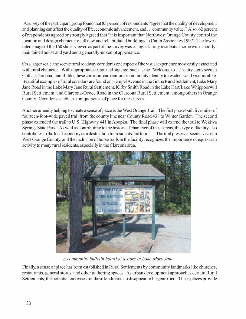
A survey of the participant group found that 85 percent of respondents “agree that the quality of developmentand planning can affect the quality of life, economic advancement, and … community value.” Also, 62 percentof respondents agreed or strongly agreed that “it is important that Northwest Orange County control thelocation and design character of all new and rehabilitated buildings.” (Canin Associates 1997). The lowestrated image of the 160 slides viewed as part of the survey was a single-family residential home with a poorly-maintained house and yard and a generally-unkempt appearance.
On a larger scale, the scenic rural roadway corridor is one aspect of the visual experience most easily associatedwith rural character. With appropriate design and signage, such as the “Welcome to …” entry signs seen inGotha, Clarcona, and Bithlo, these corridors can reinforce community identity to residents and visitors alike.Beautiful examples of rural corridors are found on Hempel Avenue in the Gotha Rural Settlement, Lake MaryJane Road in the Lake Mary Jane Rural Settlement, Kirby Smith Road in the Lake Hart/Lake WhippoorwillRural Settlement, and Clarcona-Ocoee Road in the Clarcona Rural Settlement, among others in OrangeCounty. Corridors establish a unique sense of place for these areas.
Another amenity helping to create a sense of place is the West Orange Trail. The first phase built five miles offourteen-foot-wide paved trail from the county line near County Road 438 to Winter Garden. The secondphase extended the trail to U.S. Highway 441 in Apopka. The final phase will extend the trail to WekiwaSprings State Park. As well as contributing to the historical character of these areas, this type of facility alsocontributes to the local economy as a destination for residents and tourists. The trail preserves scenic vistas inWest Orange County, and the inclusion of horse trails in the facility recognizes the importance of equestrianactivity to many rural residents, especially in the Clarcona area.
Finally, a sense of place has been established in Rural Settlements by community landmarks like churches,restaurants, general stores, and other gathering spaces. As urban development approaches certain RuralSettlements, the potential increases for these landmarks to disappear or be gentrified. These places provide
30
A community bulletin board at a store in Lake Mary Jane
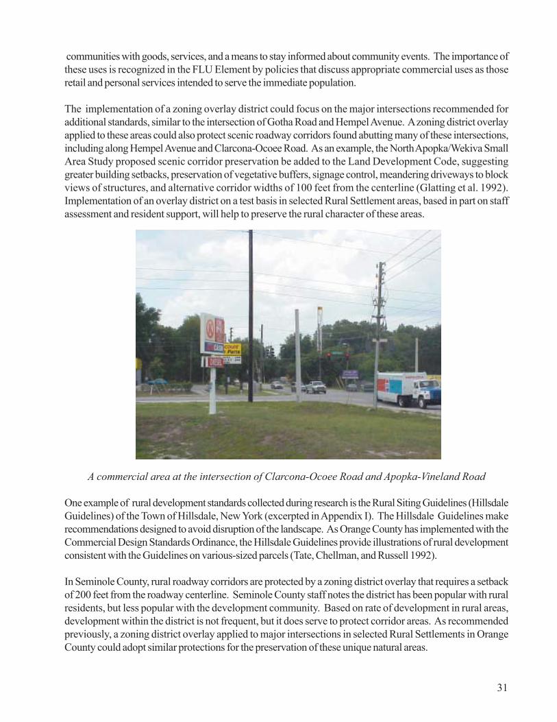
communities with goods, services, and a means to stay informed about community events. The importance ofthese uses is recognized in the FLU Element by policies that discuss appropriate commercial uses as thoseretail and personal services intended to serve the immediate population.
The implementation of a zoning overlay district could focus on the major intersections recommended foradditional standards, similar to the intersection of Gotha Road and Hempel Avenue. A zoning district overlayapplied to these areas could also protect scenic roadway corridors found abutting many of these intersections,including along Hempel Avenue and Clarcona-Ocoee Road. As an example, the North Apopka/Wekiva SmallArea Study proposed scenic corridor preservation be added to the Land Development Code, suggestinggreater building setbacks, preservation of vegetative buffers, signage control, meandering driveways to blockviews of structures, and alternative corridor widths of 100 feet from the centerline (Glatting et al. 1992).Implementation of an overlay district on a test basis in selected Rural Settlement areas, based in part on staffassessment and resident support, will help to preserve the rural character of these areas.
A commercial area at the intersection of Clarcona-Ocoee Road and Apopka-Vineland Road
One example of rural development standards collected during research is the Rural Siting Guidelines (HillsdaleGuidelines) of the Town of Hillsdale, New York (excerpted in Appendix I). The Hillsdale Guidelines makerecommendations designed to avoid disruption of the landscape. As Orange County has implemented with theCommercial Design Standards Ordinance, the Hillsdale Guidelines provide illustrations of rural developmentconsistent with the Guidelines on various-sized parcels (Tate, Chellman, and Russell 1992).
In Seminole County, rural roadway corridors are protected by a zoning district overlay that requires a setbackof 200 feet from the roadway centerline. Seminole County staff notes the district has been popular with ruralresidents, but less popular with the development community. Based on rate of development in rural areas,development within the district is not frequent, but it does serve to protect corridor areas. As recommendedpreviously, a zoning district overlay applied to major intersections in selected Rural Settlements in OrangeCounty could adopt similar protections for the preservation of these unique natural areas.
31

The preservation of rural character is subject to debate over what constitutesrural character. For example, the Wekiva River Protection Area, a 19,000-acrearea of Lake, Orange, and Seminole Counties, is required by the State of Florida’sWekiva River Protection Act (Chapter 369, Florida Statutes—see Appendix I)to remain rural in character to protect the Wekiva River system. Specifically,local government comprehensive plans must ensure that “residential developmentin the aggregate shall be of a rural density and character” (Ch. 369, F.S.).However, the statute leaves room for interpretation as to what constitutes “ruralcharacter”, leading to debate in Seminole County regarding the appropriatenessof the development proposals in the area.
Seminole County has future land use (FLU) designations of Rural 10 (maximumof one unit per ten acres or one unit per five acres, if lots are one acre in size),Rural 5 (maximum of one unit per five acres), Rural 3 (maximum of one unit perthree acres), and Suburban Estates (maximum one unit per acre), intended topreserve the viability and nature of rural areas. Seminole County also madeseveral provisions for rural areas in its 1991 Comprehensive Plan, including therecognition of rural areas and the determination that agricultural uses will be favoredin conflicts with nonagricultural uses. In addition, the intention to develop ruralcluster land development regulations and a roadway corridor overlay district toprotect the rural character of East Seminole County was included in the plan.
In 1999, Seminole County underwent public debate and planning processes onthese issues stemming from Florida Department of Community Affairs objectionsto proposed future land use amendments in Seminole County’s Wekiva RiverProtection Area and in the Chuluota area of east Seminole County. Resolutionof issues in Seminole County was achieved through a compromise that allowedmore intense development within a 400-acre transition zone in the Wekiva RiverProtection Area, as well as a reduction in dwelling units and developmentrestrictions for the proposed development. Also, a Chuluota Small Area Studyassessed conditions in east Seminole County and recommended the establishmentof Chuluota as a “rural village” and the creation of appropriate policies for futureland use, design, economic incentives, and infrastructure. Recommendations alsoincluded the identification of a village “Main Street” where retail and commercialdevelopment may be desirable in the future (Seminole County 1998).
As Orange County sees increasing urbanization based on its strong economy andother market factors, the potential increases for a debate similar to that takingplace in Seminole County. These processes have the potential for lengthy andexpensive negotiations and objections on the part of the County, developmentinterests, residents, and DCA.
Existing Rural Settlement policies, including FLU Policy 2.1.2 and 2.1.8, referencecharacter or rural character, and additional policy language should be added tomore clearly define what constitutes rural character. Additional data for this effortcan be gathered during the EAR-based amendment process, especially throughthe public participation process. The clarity provided by revised policies is an
32
The County shall developland development
regulations and land usestrategies..that recognizeEast Seminole County as
an area with specificrural character rather
than an area anticipatedto be urbanized. It shall
be the policy of theCounty that rural areasrequire approaches to
land use intensities anddensities, rural roadwaycorridor protection, the
provision of services andfacilities, environmental
protection and codeenforcement consistentwith the rural character
of such areas.
Seminole County 1991Comprehensive Plan
Future Land Use Element
“One of the most startlingthings about it is that theWekiva River ProtectionAct calls for a protectionof the rural character of
the area”, said CharlieGauthier, an
administrator for thestate Department of
Community Affairs...Butdevelopments in
Seminole [County’s]portion of the protectedarea average about two
houses for every acre, hesaid. “You have to
wonder, is that ruralcharacter?”
‘Seminole suburbs creepcloser’
The Orlando Sentinel

of [the Wekiva RiverProtection Area] is rural”,[Seminole County]Commission ChairmanRandy Morris said. “Is allof it rural? Of course not.The area we bought andprotected is beyond rural.It’s wild.” The county hasbought 800 acres of theprotected area forpreservation and hascooperated with stateagencies in otherpurchases.
‘Seminole suburbs creepcloser’The Orlando Sentinel
Even an elementary-school child knows thatthree new homes on anacre is hardly rural innature.
‘Keep it rural’The Orlando Sentinel(Editorial)
33
“I think a signicant portion
A scenic corridor along Clarcona-Ocoee Road west of the ApopkaVineland intersection in Orange County
important proactive step toward avoiding confrontation, as development proposalsfor property within Rural Settlements continue to be received from the privatesector.

34
This page intentionally left blank.

Trends and Issues
Urban Service Area Orange County is divided into Urban Service Area andRural Service Area through the use of an Urban Service Area Boundary delineatedin the Comprehensive Policy Plan (CPP). The Urban Service Area (USA) is“utilized to identify the area where Orange County has the primary responsibilityfor providing infrastructure and services to support urban development” (OrangeCounty 1991) and as a growth management tool, in that growth at urban densitiesis limited by a lack of urban services. Land outside of the USA boundary istermed Rural Service Area. In the years since the USA boundary was firstdelineated in the CPP, it has expanded through a number of future land useamendments (Appendix I). The expansion of the USAB represents the increasingurbanization of areas that were formerly rural and has implications for thedevelopment pattern seen in these areas.
The Orange County 1990-2010 Comprehensive Policy Plan establishes criteriafor the expansion of the Urban Service Area in Policies 1.1.5 through 1.1.5.2,summarized as follows: Expansion is permitted when an applicant can demonstratethat provision of infrastructure and services to the proposed project is needed tosatisfy demand for urban land based on population and employment projections;demonstrate the provision of infrastructure and services is a logical extension ofthe existing system and will not deplete capacity for vested developments; andpay for initial services and facility expansion, unless excess capacity exists. Theproposed project also must be within ten miles or twenty minutes of majoremployment centers, be contiguous to the existing USA boundary, avoid the creationof enclaves of Rural Service Area, and compatible with existing or planneddevelopment in the area. Priority is given to USA expansions involving TraditionalNeighborhood Developments with a mixture of housing types and land uses, theestablishment or relocation of a major employer, projects that contribute to theimplementation of the Development Framework, or Developments of RegionalImpact (DRI) or sector plan projects.
The USA expands in response to private-sector applications for such a changethrough the Future Land Use Map amendment process. Such expansions aresupported based on the demand for urban land resulting from population growthand projections of future growth. However, the EAR-based amendment processrepresents a valuable opportunity to assess the USA in a comprehensive,coordinated manner based on revised population estimates and a database ofcommitted land uses adjusted for market trends. As part of this process, the needfor new and redeveloped urban land will be determined using best available data,and impacts to rural areas and the rate of urbanization will be better quantified atthat time.
On a related note, the Orange County Evaluation and Appraisal Report (EAR) ofthe CPP found the population projections on which the CPP is based to be accurate.However, the EAR notes the demand for urban land was greater than
The Urban Service Areashall be based on thesupply of usable landneeded to accommodatethe County’s populationand employmentforecasts for the twentyyear planning period andthe County’s ability toprovide urban servicesand facilities….TheCounty projects that anadditional 14,801 acresdeveloped at urbandensities will be neededto accommodate futureemployment andpopulation… Shouldthese projections change,the acreage needsidentified above shall beadjusted accordingly byan amendment to thisplan.
Future Land Use ElementPolicy 1.1.2
Orange County shouldevaluate and adoptinnovative planningstrategies that wouldformalize the existingpolicy of USA expansionlimits while, at the sametime, proactively dealwith legitimate propertyrights issues.
Orange Audubon SocietyEast Orange County TaskForce Summary ofFindings
35

anticipated, due in part to the County’s share of population being greater than projected, the lower-than-expected level of multifamily development, and the popularity of small-lot subdivisions, defined as lots lessthan 61 feet in width. Real Estate Research Consultants has documented the increase in small-lot subdivisionsfrom 21 percent to 46 percent of new home sales between 1985 and 1993, with subdivisions constructed ataverage densities between 4 and 6 units per acre (Orange County 1998). The CPP projections were basedon an average of 8 units per acre in the Low-Medium Density Residential category, creating the need to reviseprojections to accommodate greater need for residential urban land.
The small-lot subdivision is a trend in home ownership, but there remains a sizable population of OrangeCounty’s citizens who either cannot afford a home or do not wish to purchase one. As Orange County’spopulation grows, these citizens are placing increasing demands on the multifamily housing stock, which has anaverage occupancy rate of 95.4 percent in the Orlando market (Orlando Sentinel 1998). Recently, citizens invarious parts of the county have expressed resistance to new multifamily housing near their neighborhoods,and several projects have not received approval based on various factors. The county has addressed thisissue under advisement from the Multifamily Compatibility Workgroup by developing a siting ordinance (Ord.#2000-08; adopted April 11, 2000) thought to address perceived issues with single-family/multifamily housingcompatibility.
The inability to develop multifamily housing on infill parcels increases the pressure for suburban expansion inrural areas to accommodate population growth. If this population cannot find multifamily housing in OrangeCounty and moves to adjacent counties, their commuting patterns to Orange County employment may increaseor cause traffic congestion on rural roads, such as Narcoossee Road in Lake Hart/Lake Whippoorwill or U.S.Highway 441, which travels though several Rural Settlements in northwest Orange County. To the degree thatpopulation growth cannot be accommodated by compact urban development, the potential exists for RuralSettlement areas to be affected.
Sector Planning As noted in various sections of this report, Orange County has been involved in sectorplanning in northwest and southwest areas of the county for some time. The Horizon West Sector Plan hasbeen adopted, and the specific plans for two villages, Lakeside Village and Bridgewater, have been adopted.The Horizon West Sector Plan is proposed for designation as a sector plan under recently-passed provisionsof Chapter 163, Florida Statutes.
The initial demonstration of the sector planning concept offered by Horizon West has been informative, and thepossibility of sector planning for other areas of the county has been discussed in public meetings of the EastOrange County Task Force and the Board of County Commissioners. Indeed, some aspects of the extensionof utility lines to east Orange County are predicated on the development of a sector plan (see Appendix C).
Regardless, another sector plan may be developed in the county, perhaps incorporating Rural Settlements, asseen in the Vision Northwest plan. Recent state legislation provides support for the concept and enables asector planning demonstration project, but the development of another sector plan is not currently planned inOrange County. The coming years may see additional sector planning efforts, but will also demonstrate theeffect of adopted sector plans on Rural Settlement areas, as discussed in the Background section.
Annexation/ Joint Planning Area Agreements A critical factor in the viability of Rural Settlements, or anyrural lands in the county, is the rate of annexation activity by the county’s municipalities; a map of municipalityand Rural Settlement boundaries is included as Appendix A. Once rural land is annexed by a municipality, it isessentially “urban land”, even if no development activity takes place immediately. The availability of municipal
36

central services usually places annexed rural land into a holding pattern, awaitingdevelopment.
Orange County has established Joint Planning Area (JPA) Agreements with severalmunicipalities in the county, with the exception of the Cities of Apopka, Eatonville,Belle Isle, and Edgewood. JPA Agreements vary by municipality, but generallyspeaking, define a zone around the municipality and specify conditions forannexations within that zone. These conditions relate to the circumstances underwhich annexations may be contested, the ability to plan for land uses within thezone, the development of infrastructure, and other concerns.
The City of Apopka’s boundaries are immediately adjacent to Clarcona, NorthApopka/Wekiva, Paradise Heights, and Zellwood Station. Three additional RuralSettlements, Otter Lake, Tangerine, and Zellwood, lie northwest of the current citylimits within several miles of the city. While Zellwood and Zellwood Station arePreservation Districts, discussed in more detail below, other Rural Settlementsmay be subject to annexation, as seen by the annexation of significant areas ofNorth Apopka/Wekiva by the City of Apopka. Orange County continues to discussa potential JPA Agreement with the City of Apopka.
The County’s Joint Planning Area agreement with the City of Ocoee addresses theannexation of the Clarcona and Gotha Rural Settlements through agreement fromthe City that these areas will not be annexed voluntarily or involuntarily and thatpreservation districts may be created for these communities. In spite of theserestrictions, the JPA reaffirms the ability of individual property owners to petitionfor amendment to the JPA and for annexation.
The Orange County/Orlando JPA boundary abuts Clarcona, Gotha, and LakeHart/Lake Whippoorwill. As the Settlements are not included within the JPA area,there are no specific references to these areas. However, the Southeast SectorPlan adopted by the City of Orlando would bring urban development to thesoutheastern edge of the JPA area directly abutting Lake Hart/Lake Whippoorwill.
Preservation Districts Enabled by Section 505 of the Orange County Charter,the creation of a preservation district establishes an exclusive procedure for municipalannexation in particular areas to preserve historical residential communities. Ifadopted by referendum, a preservation district’s land has additional scrutiny duringthe annexation request. In order to voluntarily annex property into a municipality,the Orange County Board of County Commissioners must approve the annexationthrough a majority vote at an advertised public hearing. After approval, a majorityof registered electors living within the district must approve the annexation by amajority vote. This concept does not impact involuntary annexations in such adistrict.
Preservation Districts are currently in place in Gotha, Zellwood, Zellwood Station,and in the Dr. Phillips area of southwest Orange County. Preservation Districtstatus does not have an impact on consideration of future land use and zoning forthese areas and is specifically prohibited from doing so in the enabling ordinance
“WHEREAS, thisAgreement is furtherintended (1) to protectthe Clarcona RuralSettlement and the GothaRural Settlement, (2) tofoster the objectives ofthe CountyComprehensive PolicyPlan with respect to saidrural settlements,including but not limitedto Objective 2.1 of theCounty ComprehensivePolicy Plan, and (3) toprevent annexation by theCity within the said ruralsettlements..”
Joint Planning AreaAgreement betweenOrange County and theCity of Ocoee
37
zoning decisions on community cohesiveness, the retention of which is the goal ofPreservation Districts, the establishment or revision of Future Land Use Policiesto provide additional guidance for review of proposals in Preservation Districtsshould be considered during the EAR-based amendment process.
Western Beltway Part A The Western Beltway Part A, a 10.6-mile segment ofthe Western Beltway expressway , will connect the Florida Turnpike to U.S.Highway 441 in Apopka by the year 2001. This route will provide more convenientaccess to Paradise Heights and Clarcona, as well as Rural Settlements in thenortheastern part of the county, including Bridle Path, Zellwood Station, NorthApopka/Wekiva, and Zellwood (Tangerine and Otter Lake are further north). Tothe south, the route terminates at the East/West Expressway near Gotha, withWest Windermere further south. This increased access may increase demand forresidential land at greater densities by shortening commuting distances toemployment centers for potential residents. Also, demand for commercial landlikely will increase at the sites of proposed expressway ramps.
Emergency Management In the summer of 1998, a series of wildfires in OrangeCounty threatened or burned Rural Settlement areas of Wedgefield and Christmasin east Orange County. The fires focused public attention on the area and raisedthe question among some as to the logic of developing in remote areas. TheOrlando Sentinel outlined several factors that contribute to the danger of wildfires,including rural homeowners complaints about controlled burning to manage publiclands, lack of funding for proper management of public lands, and “lax planning bylocal governments”, and notes “services such as fire protection are difficult andexpensive to provide in rural areas.” (July 12, 1998). In the summer of 2000,Orange County experienced wildfires near Wedgefield, Bithlo, Lake Mary Jane,and Christmas.
Attention has been focused on this issue by various state and federal agencies.Former Governor Lawton Chiles’ Wildfire Response and Mitigation ReviewCommittee (Committee) issued a report recommending that “local governments,in cooperation with the [Florida] Department of Community Affairs, ... promotecompact urban growth through the comprehensive planning process to preventand mitigate the potential adverse impacts if wildfires upon urbanizing areas”(Emergency Response Planning & Management 1999). It remains to be seenhow the Committee’s recommendations may influence state and local governmentpolicies and practices.
Another emergency issue, fire protection services, has been under debate in recentmonths as a result of conflict between Orange County and the City of Apopkaover the provision of services to rural areas. While this conflict is being resolvedthrough ongoing discussions, the need for other service agreements or redistributionof service routes may increase as a result of annexation activity on the part ofmunicipalities. Orange County staff should monitor emergency-related issues asconditions change in the various areas of the county.
[Florida Division ofForestry] Committee
members expressed mostconcern about what they
call the “urbaninterface”—where
wooded rural areas abutcommunities. That
invites wildfires to destroyhomes and harm people.
The committee report hitsthe mark with a strong
pitch for local governmentto discourage
development in woodedurban/suburban areas.Firefighters can defend
more easily homesconcentrated in one areathan neighborhoods that
are spread out.
‘Douse wildfire danger’The Orlando Sentinel
(Editorial)
38

Recommendations
The intent of this study is to provide context for evaluation of Rural Settlement policies and to make preliminaryrecommendations. Additional considerations and recommendations may develop as a result of publicparticipation activities during the cycle of future land use amendments to implement the Evaluation and AppraisalReport of the Orange County 1990-2010 Comprehensive Policy Plan. Preliminary recommendations are asfollows:
� Revise Future Land Use Policy 2.1.10, regarding the designation of land as Low or Low-MediumDensity Residential for the provision of affordable housing, to reference the need for availableinfrastructure. Revise language in the Housing Element relating to the provision of affordable housingin and services to Rural Settlements for in a similar fashion for consistency.
� Modify references to the creation of new Rural Settlements in Future Land Use Policy 2.1.3.
� Modify Future Land Use Policy 2.1.5, also referencing new Rural Settlements.
� Lessen the acreage threshold of 100 acres for consideration of development proposals as a PlannedDevelopment (Future Land Use Policy 2.1.6) to allow the county greater latitude for preservation ofrural character.
� Implement a slate of activities to solicit the opinions of Rural Settlement residents regarding the futureof their communities during the EAR-based amendments, with special consideration given to potentialrevision of adopted Rural Settlement boundaries.
� Revise Future Land Use Policy 2.1.14 to provide additional criteria for appropriate commercialdevelopment in Rural Settlements.
� Revisit policies regarding the extension of central water and wastewater service to Rural Settlementareas to note additional policy language that may be needed to accommodate environmental factors orchanged conditions since plan adoption to clarify under what circumstances central servicesmay be made available.
� Implement the CPP recommendation to create a specific zoning district overlay for the different RuralSettlements, addressing, at a minimum, road design, transportation access, and landscaping, asrecommended in FLU Policy 2.1.7. Provide for limited implementation on a demonstration basis atmajor intersections in selected Rural Settlements.
� Define the intent of “rural character” as referenced in FLU Policy 2.1.8. as part of the EAR-basedamendments to provide more meaningful policy direction and guidance regarding developmentproposals.
� Assess the revision and/or addition of Future Land Use Policies regarding review of future land useand zoning proposals in Rural Settlements that are Preservation Districts to help ensure that communitycohesiveness is not negatively affected by land use or zoning decisions.
39

40
This page intentionally left blank.

Bibliography
Arendt, Randall. 1994. Rural By Design: Maintaining Small Town Character. Planners Press: American Planning Association.
Canin Associates. 1997. Vision Northwest Plan: Community Visioning andPreferences.
City of Orlando Planning Department. 1998. City of Orlando Growth Management Plan Spring 1998(98-2SUA) Amendments. June 1, 1998.
East Orange County Task Force. 1998. East Orange County Task Force Summary of Findings.
Emergency Response Planning & Management. 1999. Workbook for Developing Wildfire MitigationInitiatives Pursuant to the Governor’s Wildfire Response and Mitigation Review Committee.
Ewing, Reid, et al. 1995. Best Development Practices: Doing the Right Thing and Making Money atthe Same Time. Florida Department of Community Affairs.
Florida Statutes, Chapter 369. Wekiva River Protection Act.
Glatting Lopez Kercher Anglin, Inc. 1992. North Apopka/Wekiva Small Area Study.
Miller-Sellen Associates, Inc. 1995. A Village Land Use Classification and Horizon West StudyReport.
Miller-Sellen Associates, Inc. 1992. Zellwood Station Rural Settlement Small Area Study.
Orange County Government. Joint Planning Area Agreement Between Orange County and the City ofOcoee in Futherance of Settlement of Litigation Between the Parties. February 11, 1994.
Orange County Government. Land Development Code, Section 1253.
Orange County Planning Division. 1998. Evaluation and Appraisal Report of the 1990-2010Comprehensive Policy Plan.
Orange County Planning Division. 1998. Future Land Use Amendment #99-1-A-2-3 Staff Report.
Orange County Planning Division. 2000. GIS Analysis.
Orange County Planning Division. 1990-2010 Comprehensive Policy Plan. Future Land Use Element.Adopted 1991; Amended 1998.
Orange County Planning Division. 1990-2010 Comprehensive Policy Plan. Potable Water Element.Adopted 1991; Amended 1993.
41

Orange County Planning Division. 1990-2010 Comprehensive Policy Plan. Recreation Element.Adopted 1991; Amended 1992.
Orange County Planning Division. 1990-2010 Comprehensive Policy Plan. Solid Waste Element.Adopted 1991.
Orange County Planning Division. 1990-2010 Comprehensive Policy Plan. Wastewater Element.Adopted 1991; Amended 1993.
Orlando Sentinel Editorial Board. 1998. Keep it rural. Orlando Sentinel. December 11, 1998.
Orlando Sentinel Editorial Board. 1998. Douse wildfire danger. Orlando Sentinel. November 21, 1998.
Orlando Sentinel Editorial Board. 1998. Manage paradise. Orlando Sentinel. July 12, 1998.
Russell, Joel. 1996. The Need for New Models of Rural Zoning. American Planning Association:Planners Advisory Service.
Seminole County Comprehensive Planning Division. Seminole County Chuluota Small Area Study: FinalReport. October 1998.
Shenot, Christine. 1998. A whole new world way out east. Orlando Sentinel. November 1, 1998.
Simmons, Richard G. 1951. Problems of Government in the Orlando Metropolitan Area. MastersThesis: University of Florida.
Snyder, Jack. 1998. Apartment vacancies are fewest in 9 years. Orlando Sentinel. October 14, 1998.
Tate, Anne, Chester E. Chellman, and Joel S. Russell. 1992. Proposed Rural Siting Guidelines. Townof Hillsdale, Columbia County, New York.
U.S. Bureau of the Census. 1997. Estimates of the Population of Counties for July 1, 1997, andPopulation Change: April 1, 1990 to July 1, 1997. #CO-91-1.
42