peprints.undip.ac.id/72983/3/c32_variabilities_of... · ruang lingkup dan kedalaman pembahasan...
TRANSCRIPT

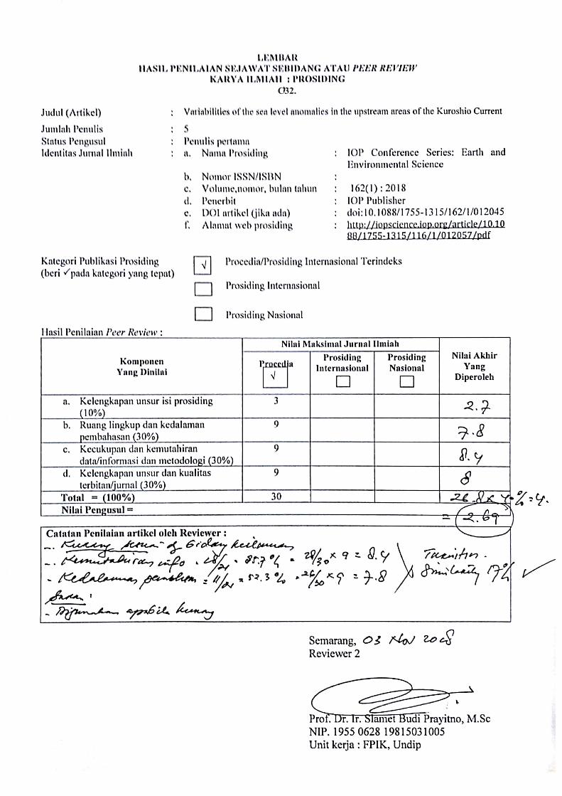
LEMBAR HASIL PENILAIAN SEJA WAT SEBIDANG ATAU PEER REVIEW
KARYA ILMIAH : PROSIDING C32.
Judul Karya Ilmiah Jumlah Penulis Status Pengusul Identitas Prosiding
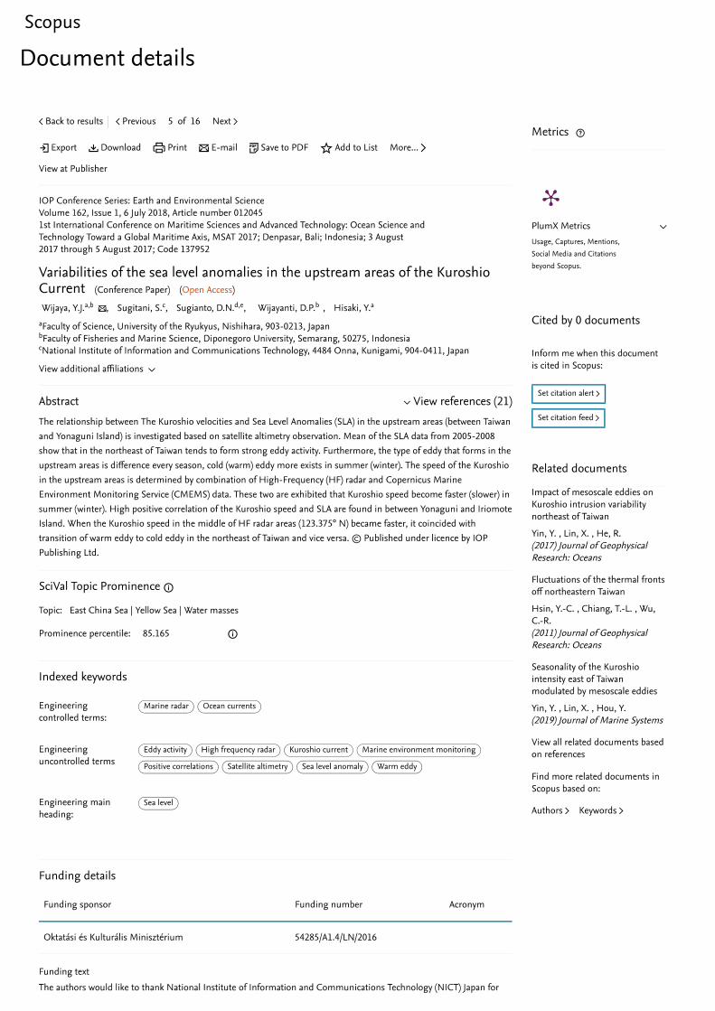
Variabilities of the sea level anomalies in the upstream areas of the Kuroshio Current 5 Orang (Y J Wijaya, S Sugitani, D N Sugianto, D P Wijayanti, and Y Hisaki) Penulis ke-4 a. Judul Prosiding
b. ISBN/lSSNc. Thn Terbit, Tempat Pelaks.d. Penerbit/Organisere. Alamat Repository/Web
Alamat Artikel
f. Terindeks di (jika ada)
1st International Conference on Maritime Sciences and Advanced Technology "Ocean Science and Technology Toward a Global Maritime Axis" IOP Conf. Series: Earth and Environmental Science (2018)
2018, IOP Publisher https://iopscience.iop.org/article/1 0. l 088/1755-1315/162/l/0 12045 http://iopscience.iop.org/article/ l 0.1088/1755-l 315/162/1/012045/pdfScopus
Kategori Publikasi Makalah (beri / pada katego · yang tepat)
: []] Prosiding Forum Ilmiah Intemasional D Prosiding Forum Ilmiah Nasional
Hasil Penilaian Peer Review
Komponen Yang Dinilai
a. Kelengkapan unsur isi prosiding (10%)b. Ruang lingkup dan kedalaman pembahasan
(30%)C. Kecukupan dan kemutahiran data/informasi dan
metodologi (30%)d. Kelengkapan unsur dan kualitas terbitan
/prosiding (30%)Total = (100%)
Semarang, Reviewer 1
Prof. Dr. Ir. Supriharyono, M.Sc NIP 195007151978021001 Unit Kerja: FPIK UNDIP
Nilai Reviewer Nilai Rata -
Rata Reviewer 1 Reviewer2
1. rP -z. r--j 7.rf
_j fly
p_ S' &? c---
2,g • .S X o. V /.,, , 2h. 1�K'tV1/. )I '1: J,- . t{I
--�6J r
Reviewer 2
C �(.7>
Prof. Dr. Ir. Slamet Budi Prayitno, M.Sc NIP. 1955062819815031005 Unit Kerja : FPlK UNDIP

C32.
C32.


⽇本語に切り替える切换到简体中文
切換到繁體中文
Русский язык
Scopus
Source details
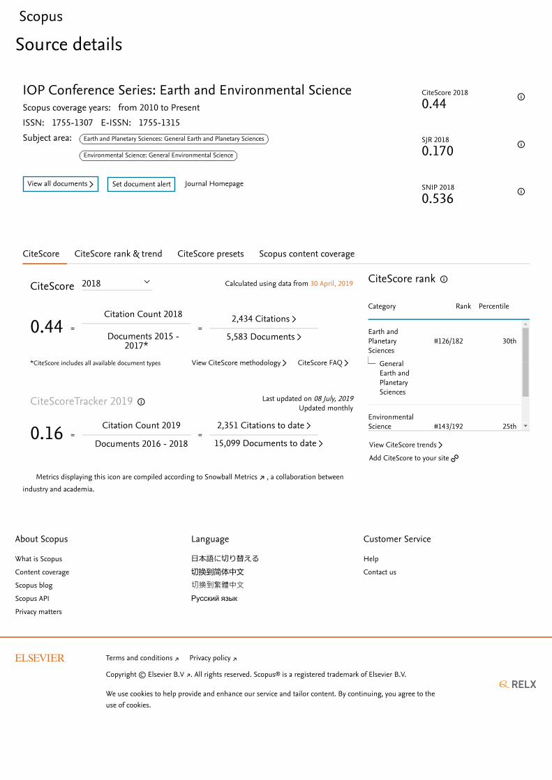
IOP Conference Series: Earth and Environmental ScienceScopus coverage years: from 2010 to PresentISSN: 1755-1307 E-ISSN: 1755-1315Subject area: Earth and Planetary Sciences: General Earth and Planetary Sciences
Environmental Science: General Environmental Science
View all documents ▻ Set document alert Journal Homepage
CiteScore 2018
0.44
SJR 2018
0.170
SNIP 2018
0.536
CiteScore CiteScore rank & trend CiteScore presets Scopus content coverage
Calculated using data from 30 April, 2019CiteScore
*CiteScore includes all available document types
0.44 =
Citation Count 2018
Documents 2015 -2017*
=
Metrics displaying this icon are compiled according to , a collaboration betweenindustry and academia.
2018
▻2,434 Citations
▻5,583 Documents
▻View CiteScore methodology ▻CiteScore FAQ
Last updated on 08 July, 2019CiteScoreTracker 2019
0.16 = Citation Count 2019
Documents 2016 - 2018 =
Updated monthly
▻2,351 Citations to date
▻15,099 Documents to date
↗ Snowball Metrics
CiteScore rank
Category Rank Percentile
Earth andPlanetarySciences
#126/182 30th
EnvironmentalScience
#143/192 25th
GeneralEarth andPlanetarySciences
▻View CiteScore trends
🔗Add CiteScore to your site
About Scopus
What is Scopus
Content coverage
Scopus blog
Scopus API
Privacy matters
Language
⽇本語に切り替える切换到简体中文
切換到繁體中文
Русский язык
Customer Service
Help
Contact us
Copyright © . All rights reserved. Scopus® is a registered trademark of Elsevier B.V.
We use cookies to help provide and enhance our service and tailor content. By continuing, you agree to the.
↗Terms and conditions ↗Privacy policy
↗Elsevier B.V
use of cookies

https://fitb.itb.ac.id/event/1st-international-conference-on-mariteme-science-and-advanced-technology-msat/
HOME PROGRAM REGISTRATION VENUE & ACCOMODATION
PREVIOUS EVENT
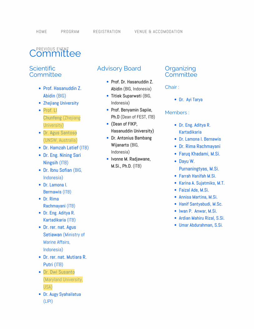
Scientific Committee
• Prof. Hasanuddin Z. Abidin (BIG)
• Zhejiang University• Prof. LI
Chunfeng (Zhejiang University)
• Dr. Agus Santoso (UNSW, Australia)
• Dr. Hamzah Latief (ITB)• Dr. Eng. Nining Sari
Ningsih (ITB)• Dr. Ibnu Sofian (BIG,
Indonesia)• Dr. Lamona I.
Bermawis (ITB)• Dr. Rima
Rachmayani (ITB)• Dr. Eng. Aditya R.
Kartadikaria (ITB)• Dr. rer. nat. Agus
Setiawan (Ministry of Marine Affairs, Indonesia)
• Dr. rer. nat. Mutiara R. Putri (ITB)
• Dr. Dwi Susanto (Maryland University, USA)
• Dr. Augy Syahailatua (LIPI)
Advisory Board
• Prof. Dr. Hasanuddin Z. Abidin (BIG, Indonesia)
• Titiek Suparwati (BIG, Indonesia)
• Prof. Benyamin Sapiie, Ph.D (Dean of FEST, ITB)
• (Dean of FIKP, Hasanuddin University)
• Dr. Antonius Bambang Wijanarto (BIG, Indonesia)
• Ivonne M. Radjawane, M.Si., Ph.D. (ITB)
Organizing Committee
Chair :
• Dr. Ayi Tarya
Members :
• Dr. Eng. Aditya R. Kartadikaria
• Dr. Lamona I. Bernawis• Dr. Rima Rachmayani• Faruq Khadami, M.Si.• Dayu W.
Purnaningtyas, M.Si.• Farrah Hanifah M.Si.• Karina A. Sujatmiko, M.T.• Faizal Ade, M.Si.• Annisa Martina, M.Si.• Hanif Santyabudi, M.Sc.• Iwan P. Anwar, M.Si.• Ardian Mahiru Rizal, S.Si.• Umar Abdurahman, S.Si.
Committee

1
Content from this work may be used under the terms of the Creative Commons Attribution 3.0 licence. Any further distributionof this work must maintain attribution to the author(s) and the title of the work, journal citation and DOI.
Published under licence by IOP Publishing Ltd
1234567890 ‘’“”
MSAT IOP Publishing
IOP Conf. Series: Earth and Environmental Science 162 (2018) 012002 doi :10.1088/1755-1315/162/1/012002
Evaluation of a global ocean general circulation model; The
Lat-Lon-Cap (LLC90) configuration of the MITgcm
Bernawis Lamona1, Judith Hauck2 and Christoph Völker2
1Department of Oceanography, Institut Teknologi Bandung, Indonesia 2Alfred Wegener Institute, Germany
E-mail: [email protected]
Abstract. An evaluation of a general circulation model from Massachusetts Institute of
Technology (MITgcm) with Lat – Lon – Cap (LLC90) configuration was done. Simulation of
100 years yields the annual means of potential temperature, salinity, meridional overturning
stream function and transport of several throughflows. A reference run with widened Davis
strait from the model was used to compare with observational WOA09 data, and the MITgcm
has reproduced reasonably reliable data. The patterns of potential temperature can resemble the
WOA09, however not so for the salinity fields. An experiment to simulate the model in 5
different tuning set were then proceeded. For the potential temperature and salinity fields, the
North Pacific and the Southern Ocean still has significant difference to the WOA09. The
difference was in the range of -6 to 5 ⁰C for the potential temperature and -0.5 to 3 psu for the
salinity field. The meridional overturning circulation stream function was still lower than the
observational (± 17 Sv); the MITgcm simulates it 10 ± 1Sv in the experiment. The root mean
square (RMS) of the difference were calculated, the surface layer has the largest magnitude of
difference due to the forcing dynamics. The best simulation, which has the least difference to
WOA09, was the one with the original bathymetry and smallest vertical diffusivity coefficient,
1 x 10⁻⁵ m2 s-1.
1. Introduction
MITgcm is widely used by oceanographers in wide spectrum of expertise; physics, biology, chemistry,
and ocean-atmosphere interactions among others. The uniqueness of this general circulation model is
that it employs the non-hydrostatic equation and fluid isomorphism to simulate fluid phenomena of
both ocean and atmosphere, from the small scale of convection with 100m range to the general
circulation of the world ocean on a scale of thousands of kilometers. In our simulations we used a
resolution of 1⁰. Marshall [1] elaborated ocean models based on hydrostatic primitive equations (HPE), quasi
hydrostatic (QH) and non-hydrostatic (NH) equations. In HPE, the vertical momentum equation is
reduced to hydrostatic balance and an approximation is made with approximated Coriolis force and a
shallow atmosphere approximation is made. With this, in large scale, the terms omitted in HPE are
negligible, but on a small scale they become large enough to become a problem. For the application to

1
Content from this work may be used under the terms of the Creative Commons Attribution 3.0 licence. Any further distributionof this work must maintain attribution to the author(s) and the title of the work, journal citation and DOI.
Published under licence by IOP Publishing Ltd
1234567890 ‘’“”
MSAT IOP Publishing
IOP Conf. Series: Earth and Environmental Science 162 (2018) 012031 doi :10.1088/1755-1315/162/1/012031
Effects of artificial and natural materials ropes as
substrates for settling and metamorphosis of pediveliger
pearl oyster, Pinctada maxima (Jameson, 1901)
Medy Ompi1, Fontje Kaligis1, Stephanus Mandagi1, and Kathe Jensen2
1Department of Natural Water Resources Management, Faculty of Fisheries and
Marine Sciences University of Sam Ratulangi, Indonesia 2Zoologisk Museum, Copenhagen, Denmark
E-mail: [email protected]
Abstract. A study aimed at investigating the effects of four different materials ropes as
substrates for settling and metamorphosis of tropical oyster, Pinctada maxima,
pediveligers was conducted at laboratory scale. The number of pediveligers attached and
metamorphosed on each substratum were counted at the terminat ion of the experiment.
Increment in shell length during settling and metamorphosis was also measured. Settling
and metamorphosis were analyzed using One-Way ANOVA with substratum as the main
effect. Two-Way ANOVA with time and substratum as the main effect on growth was
also tested. The results showed that the settling and metamorphosis of pediveliger were
affected by the substratum. The number of settled and metamorphosed pediveligers on
polypropylene rope, natural ropes of Arenga piñata and Cocos nucifera was significantly
higher than on the bottom of Pyrex glasses. No significant difference between numbers of
larvae settled on polypropylene and natural ropes of Arenga piñata and Cocos nucifera
appeared. A significant effect of time, but not of substratum, on growth occurred.
Overall, settling and metamorphosis of P. maxima pediveliger larvae were strongly
affected by artificial and natural ropes, while metamorphosis occurred haphazardly on the Pyrex glass. Growth occurred after settling and metamorphosis.
1. Introduction
Pearl oysters, Pinctada maxima (Jameson, 1901), have been actively cultured and developed to be the
main pearl oyster industry in North Sulawesi. Spat of this pearl oyster is mainly supplied from
hatcheries or collected from the oyster bed using spat collectors. Nowadays the use of polypropylene
and monofilament as substrate for spat collectors has been intensified. Yet the unused materials are
being dumped into the sea and become wastes, affecting benthic organisms as it may be ingested,
accumulated and possibly transferred to higher throphic levels. According to Chae & Joo An (2017),

1
Content from this work may be used under the terms of the Creative Commons Attribution 3.0 licence. Any further distributionof this work must maintain attribution to the author(s) and the title of the work, journal citation and DOI.
Published under licence by IOP Publishing Ltd
1234567890 ‘’“”
MSAT IOP Publishing
IOP Conf. Series: Earth and Environmental Science 162 (2018) 012033 doi :10.1088/1755-1315/162/1/012033
Depositional environmental evolution of Kalibiuk formation based on paleontological molluscan Study, Cisaat River section, Bumiayu, Central Java, Indonesia
Aswan1, Elina Sufiati2, Alfend Rudyawan1, Desty Kistiani2, and Thaw Zin Oo3
1 Geology Department, Faculty of earth Sciences and Technology, Institute of Technology Bandung, Jalan Ganesa 10 Bandung, Indonesia 2 Geological Museum Bandung, Jalan Diponegoro No.57, Bandung, Indonesia 3 Geology Department, East Yangon University, Thanlyin Township, Yangon Division, Myanmar
E-mail: [email protected]
Abstract. This paper presents new finding from the sedimentary sequences, overlooked by previous researchers, which provide insights to the sea level changes during the deposition of the Middle to Late Pliocene Kalibiuk Formation. Data were acquired from fieldwork via detailed measured section of each sedimentary sequence from the bottom to the upper part of the formation followed by molluscan fossil association analyses. Lithologically, the Cisaat River stratigraphic section is dominated by greenish grey claystone with some light grey fine-grained sandstone intercalation. Based on about 50 m stratigraphic section, 10 molluscan fossils associations were successfully determined. The sequence from bottom to top are: Corbula– Natica association, Nassa sp. association, Olividae – Turricula association, Pecten – Telina association, Telina – Placuna association, Corbula – Marginella association, Placuna – Natica association, Turritella association, Turritella – Marginella association and Dentalina – Architectonica association. Changes in vertical succession of the molluscan association indicates a development from shallow marine to terrestrial depositional environment before gradually overlain by terrestrial sediments of the Kaliglagah Formation. At least there are 2 deepening - shallowing sea level cycles during the deposition of Kalibiuk Formation observed from this section.
1. IntroductionThe Cisaat River traverse is located to the southwest of Bumiayu, Central Java, Indonesia (Figure 1).Standard geological map of the area referred to the Majenang sheet [1], bounded by the followingcoordinates: 7º 09’ 20.55” S; 108º 57’ 13.41” E - 7º 09’ 34.53” S; 108º 57’ 21.76” E. The traverse,administratively, belong to the Bantarkawung district, Brebes, Central Java Province. This study focuses on the upper part of the Pliocene Kalibiuk Formation [1] and the lower part of the Pleistocene Kaliglagah Formation (Figure 2) with general bedding attitude N060°E/30°SE. This interval is included into the Cheribonian stage in the Neogene stages of Jawa [2] based on the mollusc fossils occurrence or the Zanclian stage in the international geological time scale. This research was carried out due to the abundance and continuous occurrence of marine mollusc fossils across the vertical succession of the formation along the traverse and rare occurrence of benthic forams that are usually used to determine

1
Content from this work may be used under the terms of the Creative Commons Attribution 3.0 licence. Any further distributionof this work must maintain attribution to the author(s) and the title of the work, journal citation and DOI.
Published under licence by IOP Publishing Ltd
1234567890 ‘’“”
MSAT IOP Publishing
IOP Conf. Series: Earth and Environmental Science 162 (2018) 012038 doi :10.1088/1755-1315/162/1/012038
Estimation of marine gravity anomaly model from satellite
altimetry data (Case Study : Kalimantan and Sulawesi
Waters-Indonesia)
P Hartanto1, S Huda1, W Putra1, E D Variandy1, B Triarahmadhana1, D
Pangastuti1, A M Pahlevi1 and C Hwang2
1 Geospatial Information Agency of Indonesia, Jl. Raya Jakarta-Bogor Km. 46,
Cibinong 16911, West Java, Indonesia 2 National Chiao Tung University, 1001 University Road, Hsinchu, Taiwan 300, ROC
E-mail: [email protected]
Abstract. Nowadays satellite altimetry has become an advanced instrument to observe many
natural physical phenomena, such as sea-level rise, ocean circulation, water mass changes, and
marine gravity anomaly. The use of satellite altimetry data to compute marine gravity anomaly
provides good results and costs relatively low. Those advantages make geodesists utilize this
method as an alternative in geoid determination, especially over the seas. Several sets of satellite
altimetry data from Cryosat 2, Jason 1 phase C, Geosat and ERS1 were used to compute gravity
anomaly over the surrounding waters of Kalimantan and Sulawesi Island in Indonesia. The study
area spans between -70-70 N and 1080-1270 E with a spatial resolution of 1’x1’. In the pre-
processing step, the altimetry data especially Geosat and ERS1, were retracked to reduce errors
due to the land influence. The main computation step was done by using two different methods,
least square collocation (LSC) and Inverse Vening-Meinesz (IVM). The computed gravity
anomaly models then assessed with the in-situ marine gravity data from the National
Geophysical Data Center (NGDC). The best model in term of RMS error is the 10 km Gaussian
filtered LSC with an RMS error of 15.042 mgal. The least accurate model is the non-filtered IVM with an RMS of 16.704 mgal.
1. Introduction
The Kalimantan and Sulawesi are two main islands of Indonesian Archipelago. In order to determine
the regional geoid, the government of Indonesia in collaboration with Technical University of Denmark
(DTU) ran airborne gravity surveys over those two Islands in 2008-2009 [1]. However, the surveys did
not cover the waters surrounding those two islands [2]. In order to fill those gaps, some geodetic mission
altimetry datasets were used to determine the gravity anomalies over an area between 7⁰S - 7⁰ N and
108⁰E - 127⁰E. The datasets consist of Sea Surface Height (SSH) measured by Cryosat-2, Jason-1 phase
C, Geosat and ERS-1 satellite altimetry missions. By definition, SSH is the difference of altimeter range
from the satellite altitude above the reference ellipsoid [3], or in another word SSH is the height of
instantaneous sea surface above the reference ellipsoid.
To make the SSH data usable in gravity anomaly determination, some accuracy defects related to
land occurrence should be reduced by performing waveform retracking. Waveform retracking was
performed to fit a model or functional form to the measured waveforms, and retrieve geophysical

8/1/2019 IOP Conference Series: Earth and Environmental Science, Volume 162, 2018 - IOPscience
https://iopscience.iop.org/issue/1755-1315/162/1 1/8
Table of contents
View all abstracts
Accepted papers received: 5 June 2018Published online: 6 July 2018
Preface
Papers
Ocean and Coastal Dynamics
This site uses cookies. By continuing to use this site you agree to our use of cookies. To find outmore, see our Privacy and Cookies policy.
Volume 1622018
Previous issue Next issue
1st International Conference on Maritime Sciences and Advanced Technology "OceanScience and Technology Toward a Global Maritime Axis"3–5 August 2017, Denpasar, Bali, Indonesia
011001OPEN ACCESS
1st International Conference on Maritime Sciences and Advanced Technology "OceanScience and Technology Toward a Global Maritime Axis"
View article PDFView abstract
011002OPEN ACCESS
Peer review statement View article PDFView abstract
012001OPEN ACCESS
Ocean numerical model experiment on estimating the variation of volume and heattransport in Karimata straitI P Anwar, M R Putri and A Setiawan
View article PDFView abstract
8/1/2019 IOP Conference Series: Earth and Environmental Science, Volume 162, 2018 - IOPscience
https://iopscience.iop.org/issue/1755-1315/162/1 2/8
012002OPEN ACCESS
Evaluation of a global ocean general circulation model; The Lat-Lon-Cap (LLC90)configuration of the MITgcmBernawis Lamona, Judith Hauck and Christoph Völker
View article PDFView abstract
012003OPEN ACCESS
The roles of mixed layer depth in affecting chemical and biological characteristics ofMakassar straits, IndonesiaI C Dewi, M R Putri and A Setiawan
View article PDFView abstract
012004OPEN ACCESS
The study of MJO impact on wave height and wind speed in Indonesian SeasI Hilmi, N S Ningsih, I Sofian, F Hanifah and A M Rizal
View article PDFView abstract
012005OPEN ACCESS
Integrated 3D numerical modeling during La Niña and El Niño events using RegionalOcean Modeling System (ROMS) in Makassar Strait: preliminary studyS Mubarrok, M Riza, A A Nur and I Mandang
View article PDFView abstract
012006OPEN ACCESS
The changes of water mass characteristics using 3-dimensional Regional OceanModeling System (ROMS) in Balikpapan bay, IndonesiaA A Nur, I Mandang, S Mubarrok and M Riza
View article PDFView abstract
012007OPEN ACCESS
Numerical modeling of wave-current interaction in Merak Port, IndonesiaS Nurfitri, N S Ningsih, A N Sentanu and R Rachmayani
View article PDFView abstract
012008OPEN ACCESS
Environmental assessment of Pari Island towards oil spill using Geographic InformationSystem (GIS): a preliminary studyS Nurfitri, M Raihan, M R Putri, A Setiawan, M Gade and T Pohlmann
View article PDFView abstract
012009OPEN ACCESS
Image side-scan sonar segmentation for seafloor detection in Lembeh strait, Bitung,North Sulawesi
8/1/2019 IOP Conference Series: Earth and Environmental Science, Volume 162, 2018 - IOPscience
https://iopscience.iop.org/issue/1755-1315/162/1 3/8
Air-Sea Interaction and Climate Variability
Rina Nurkhayati, Henry M Manik, Totok Hestirianoto, Susilohadi and Delyuzar Ilahude
View article PDFView abstract
012010OPEN ACCESS
Temperature-Salinity stratification in the Eastern Indian Ocean using argo floatN P Purba, W S Pranowo, I Faizal and H Adiwira
View article PDFView abstract
012011OPEN ACCESS
Monochromatic interfacial wave propagating over one and two bar(s)L H Wiryanto
View article PDFView abstract
012012OPEN ACCESS
Numerical simulation of internal wave propagation over a variable topographyR K Yasmin and S R Pudjaprasetya
View article PDFView abstract
012013OPEN ACCESS
Study of coastal flooding in Kupang, East Nusa Tenggara due to Tropical CycloneFrances (case study April 27 – 30 2017)I G A P P Astiduari, T H A Rasyiid and I R Nugraheni
th th
View article PDFView abstract
012014OPEN ACCESS
Characteristics of diabatic heating associated with mesoscale convective systems overIndian Ocean from radiosonde and GPS radio occultationKhairunisa Febrina, Tri Wahyu Hadi and Noersomadi
View article PDFView abstract
012015OPEN ACCESS
Semiannual variation of zonal current along the equatorial Indian OceanFaruq Khadami, Totok Suprijo and Iskhaq Iskandar
View article PDFView abstract
012016OPEN ACCESS
Interannual variability of sea surface height difference between western Pacific Oceanand eastern Indian Ocean and its effect to geostrophic current in Lombok StraitH A Rejeki, Kunarso and Munasik
View article PDFView abstract

8/1/2019 IOP Conference Series: Earth and Environmental Science, Volume 162, 2018 - IOPscience
https://iopscience.iop.org/issue/1755-1315/162/1 4/8
Marine Disaster and Hazards & Marine Degredation
Living Marine Resources (Sub-theme: Coastal Conservation, Biodiversity, Marine Pollutant,Marine Food Security and Aquaculture)
012017OPEN ACCESS
Water temperature variation of Segara Anakan, Sempu Island, South Malang, Indonesiain relation to the climate variationA Sartimbul, H Nakata, E Rohadi, S H J Sari, M Najib, S Alisafira, S N Ikhsani and D Listiyaningsih
View article PDFView abstract
012018OPEN ACCESS
Analysis of daily wind circulation toward sea level rise in SemarangN Fitrianti, Y D Haryanto, E V S Simamora, H F A Bintari, A Hartoko, S Anggoro and M Zainuri
View article PDFView abstract
012019OPEN ACCESS
Spatial multi criteria approach for tsunami risk assessmentAbu Bakar Sambah, F Miura, Guntur and Fuad
View article PDFView abstract
012020OPEN ACCESS
Critical-phase sea dike construction of NCICD program in Jakarta as national capital cityH Suprayogi, A Rudyanto, H Bachtiar and L M Limantara
View article PDFView abstract
012021OPEN ACCESS
Nitrate and phosphate from rivers as mitigation of eutrophication in Benoa bay, Bali-IndonesiaY Suteja and A I S Purwiyanto
View article PDFView abstract
012022OPEN ACCESS
Identification of Decapterus sp. potential fishing grounds in Java and WesternKalimantan SeasAvrionesti and M R Putri
View article PDFView abstract
012023OPEN ACCESS
Microplastics in Sumba waters, East Nusa TenggaraM R Cordova and U E Hernawan
View article PDFView abstract

8/1/2019 IOP Conference Series: Earth and Environmental Science, Volume 162, 2018 - IOPscience
https://iopscience.iop.org/issue/1755-1315/162/1 5/8
012024OPEN ACCESS
Measurement and analysis of acoustic backscattering strength for characteristics ofseafloor sediment in Indian Ocean WPP 572-573Fauziyah, A Priatna, W F Prakoso, T Hidayat, H Surbakti and E Nurjuliasti
View article PDFView abstract
012025OPEN ACCESS
Primary productivity of coastal ecosystems in the Seribu Islands (case study on KelapaDua Island, Pramuka Island and Pari Island)Y A Nurrahman and S Nurdjaman
View article PDFView abstract
012026OPEN ACCESS
Study of biophysical status and resources support marine tourism area of mangrove inIndramayu KarangsongDonny Juliandri Prihadi, Indah Riyantini and Mochamad Rudyansyah Ismail
View article PDFView abstract
012027OPEN ACCESS
Quantitative assessment of vulnerability in aquaculture: climate change impacts onwhiteleg shrimp (Litopenaeus vannamei) farming in East Java ProvinceA D Puspa, T Osawa and I W Arthana
View article PDFView abstract
012028OPEN ACCESS
Developing one map of national marine resources of IndonesiaNurwadjedi, Sri Hartini and Lien Rosalina
View article PDFView abstract
012029OPEN ACCESS
Aesthetic quality assessment in Santolo Beach, West Java Province, IndonesiaAnkiq Taofiqurohman, Ivonne M Radjawane and Yayat Dhahiyat
View article PDFView abstract
012030OPEN ACCESS
Potential of methanol extract from the stem bark of mangrove Rhizophora mucronataagainst bacteria Escherichia coli and Aeromonas hydrophyllaMahmiah, Giman, Nanik Siti Aminah and Mulyadi Tanjung
View article PDFView abstract
012031OPEN ACCESS
Effects of artificial and natural materials ropes as substrates for settling andmetamorphosis of pediveliger pearl oyster, Pinctada maxima (Jameson, 1901)

8/1/2019 IOP Conference Series: Earth and Environmental Science, Volume 162, 2018 - IOPscience
https://iopscience.iop.org/issue/1755-1315/162/1 6/8
Non-living Marine Resources (Sub-theme: Marine Geology and Marine Renewable Energy)
Satellite and Ocean Remote Sensing
Medy Ompi, Fontje Kaligis, Stephanus Mandagi and Kathe Jensen
View article PDFView abstract
012032OPEN ACCESS
Spatial assessment of relative resilience potential to support management of coral reefecosystem in Doreri Bay area, Manokwari Regency, IndonesiaT F Pattiasina, A Sartimbul, B Semedi, E Y Herawati, D D Pelasula, M Krey and Mulyadi
View article PDFView abstract
012033OPEN ACCESS
Depositional environmental evolution of Kalibiuk formation based on paleontologicalmolluscan Study, Cisaat River section, Bumiayu, Central Java, IndonesiaAswan, Elina Sufiati, Alfend Rudyawan, Desty Kistiani and Thaw Zin Oo
View article PDFView abstract
012034OPEN ACCESS
Ichnofossils study of paleocene sediment source rock cores from Bintuni basin, WestPapua, Eastern IndonesiaAswan, Alfend Rudyawan and Thaw Zin Oo
View article PDFView abstract
012035OPEN ACCESS
Chlorophyll-A variability in the southern coast of Java Island, Indian Ocean:corresponding to the tropical cyclone of ErnieU Efendi, A Fadlan and A M Hidayat
View article PDFView abstract
012036OPEN ACCESS
The readiness of small island community to the development of potential renewableenergy: case study of Bulang Kebam Island, Riau Island province, IndonesiaP A Soejarwo, W P Fitriyanny, A R Hakim and A Heriati
View article PDFView abstract
012037OPEN ACCESS
Study of ocean thermal energy resources in Para'baya, West SulawesiY B Wicaksono and M R Putri
View article PDFView abstract
012038OPEN ACCESS

8/1/2019 IOP Conference Series: Earth and Environmental Science, Volume 162, 2018 - IOPscience
https://iopscience.iop.org/issue/1755-1315/162/1 7/8
Estimation of marine gravity anomaly model from satellite altimetry data (Case Study : Kalimantanand Sulawesi Waters-Indonesia)P Hartanto, S Huda, W Putra, E D Variandy, B Triarahmadhana, D Pangastuti, A M Pahlevi and C Hwang
View article PDFView abstract
012039OPEN ACCESS
GEOBIA an (Geographic) Object-Based Image Analysis for coastal mapping inIndonesia: A ReviewF Hidayat, A W Rudiastuti and N Purwono
View article PDFView abstract
012040OPEN ACCESS
Utilization of AIS (Automatic Identification System) sensor for mobility monitoring offishing vessel based on PFZ (Potential Fishing Zones) distributionS M Purnama, D Y Hutapea and R Permala
View article PDFView abstract
012041OPEN ACCESS
Salt pond analysis using ALOS PALSAR case study Sampang, Madura-IndonesiaS M Purnama, A Cahyawati and D Y Hutapea
View article PDFView abstract
012042OPEN ACCESS
Identification of flood area in the coastal region using remote sensing in KarawangRegency, West JavaBambang Riadi, Baba Barus, Widiatmaka, Moh Yanuar and Bambang Pramudya
View article PDFView abstract
012043OPEN ACCESS
Long term variation of sea level anomaly (September 1992-January 2017) in theIndonesian sea from multi-mission satellite altimetry dataDina A. Sarsito, Kosasih Prijatna, Dudy D. Wijaya, T Nur Fajar, Ivonne M. Radjawane, Wiwin Windupranataand Brian Bramanto
View article PDFView abstract
012044OPEN ACCESS
Oceanographic factors related to Eastern Little Tuna (Euthynnus affinis) catches in thewest Java SeaMega Syamsuddin, Sunarto and Lintang Yuliadi
View article PDFView abstract
012045OPEN ACCESS
Variabilities of the sea level anomalies in the upstream areas of the Kuroshio Current

8/1/2019 IOP Conference Series: Earth and Environmental Science, Volume 162, 2018 - IOPscience
https://iopscience.iop.org/issue/1755-1315/162/1 8/8
Marine Technology (Sub-theme: Offshore Technology, Underwater Acoustic and OceanObservation)
JOURNAL LINKS
Journal home
Information for organizers
Information for authors
Search for published proceedings
Contact us
Reprint services from Curran Associates
Y J Wijaya, S Sugitani, D N Sugianto, D P Wijayanti and Y Hisaki
View article PDFView abstract
012046OPEN ACCESS
Analysis of dissemination methods for remote sensing information in maritime field tosupport the local governmentG D Yudha and S M Purnama
View article PDFView abstract
012047OPEN ACCESS
Predictor-corrector scheme for simulating wave propagation on shallow water regionRifky Fauzi and L. Hari Wiryanto
View article PDFView abstract
012048OPEN ACCESS
Monitoring remote tidal based on webEngki A Kisnarti and Suryadhi
View article PDFView abstract
012049OPEN ACCESS
Stress concentration factor distribution of inclined brace in multiplanar offshore tubulardouble kt jointsRudi Walujo Prastianto, Yoyok Setyo Hadiwidodo, Ibnu Fasyin Fuadi, Mhd Bonar Yudha Prawira Naibaho andPrasetyo Nugroho Rahardianto
View article PDFView abstract
