rpt on stripping percussion drilling & assaying
TRANSCRIPT
41l96SW99e7 2.12139 LORNE 010
REPORT ON
STRIPPING, PERCUSSION DRILLING AND ASSAYING
FOR
LONGOLD RESOURCES INC.
JUNE RESOURCES INC.
MARGE ENTERPRISES LTD.
Lorne Township
Sudbury Mining Division Ontario
RECEIVED
FEB l 1989
MINING LANDS SECTION
Sudbury Geological Services Inc. L. J. Bardswich, P. Eng. January 15, 1989

41ie6SWW*7 2 .12139 LORNE 01OC
TABLE OF CONTENTS
INTRODUCTION
LOCATION AND ACCESS
CLAIMS
PREVIOUS WORK
GEOLOGY
STRIPPING
PERCUSSION DRILLING
SAMPLE COLLECTION
ASSAY RESULTS
RECOMMENDATIONS AND CONCLUSIONS
CERTIFICATE OF QUALIFICATION
FIGURE 1) LOCATION MAP2) CLAIMS MAP3) DRILL HOLE LOCATIONS
TABLE l ASSAY RESULTS
K^T^ ''z&t^n&rSSttt^heO-^^v^^ /^-f II l] toftj/ 7?*!*.' l' Jf^\tt
^^^^g^yfSsyrrxy x" *s "NI^^•zsr^f—j jg" "~ y **^SF-~' ?*S G^^CT^ "5^'.clfe:^^^W/ht^T-^ Xq7Ni.Cu|,.i'iP^;S^-^^^^^H.^7^^
S^^^A'''*'^-^^ri/!^^!•TSr'l^r ^^-VMCiaifcJr ,1M^V"Ar
^^^s^SS^p^^?^2^^^^^P' ^
^'^S^^i^^'T T"7c: i^^ ir^--vf;^^^r^- "̂ ^^SjaagLm. /TV * "-^Ssn.* ^t*V^':' i*^*''-/"'. •.*w*:i*?rlwr.. :W "•jz**.* -'^i^L *""- ^^-^™-^*Jtf^ ti~^. * .7^ -~i*~?*fc: .;t"tw*"'":^'' -i-__ T./ "l _______^/-_____\ j_____y^--/•' n '' "^•'^*u? il4-"-T*'";u. x ^ ^n "7 rrr—r '••13^———^/,-'' -H, i-p^TN** J-'V'—: . .li^ :u i * ^ M. i - 1* -... ; i rt —- -, -u, i-j--^'T"^11 ,*-;-,; V^'TT^y"
^s-U V ^*s^S* •ISTp^ 'nu\r...4.x ^ *.^.^U^^.
fe" /rjife
8 66'W
dM
l 3
Sin
Ol"
\ ! x^0^
V--i
\ "^:
SU
DB
UR
YM
ININ
G D
IVIS
ION*i
- -* •*S
CA
LE
: l INC
H
10 C
HA
INS
11
/2 M
ILE
)
INTRODUCTION
This report summarizes a short program of stripping,
percussion drilling and assaying conducted on the 11 claims
Lorne Township North Property (Tamminen property) optioned to
Longold Resources Inc. ( 5Q%), June Resources Inc. (253Q and
Marge Enterprises Ltd. (25SS). The program was conducted in
early September, 1988.
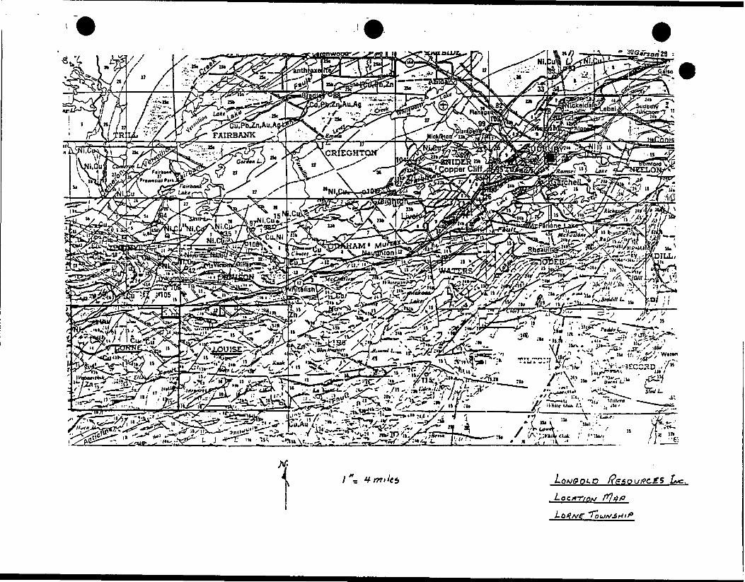
LOCATION AND ACQESS
The property consists of 11 contigrous claims located in Lots
l and 2, Concession VI of Lorne Township, Sudbury Mining
Division.
Access is westward from Sudbury on Hwy. 17 approximately 30
km, thence northerly on Hwy. 658 approximately 9 km to the
Worthington townsite, thence westerly and southerly on the
Totten Mine Road approximately l 1/2 km to the Johnson Farm,
thence southerly on a trail to claim #827049, the site of a
copper-gold showing.
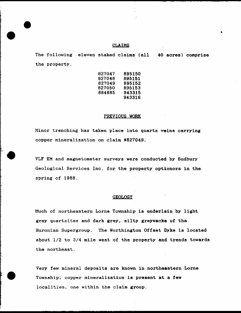
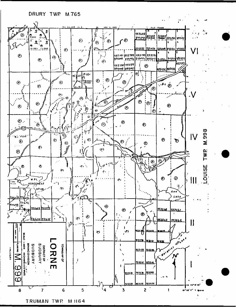
CLAIMS
The following eleven staked claims (all 40 acres) comprise
the property.
827047 827048 827049 827050 884885
895150 895151 895152 895153 943315 943316
PREVIOUS WORK
Minor trenching has taken place into quartz veins carrying
copper mineralization on claim 1*827049.
VLF EM and magnetometer surveys were conducted by Sudbury
Geological Services Inc. for the property optionors in the
spring of 1988.
GEOLOGY
Much of northeastern Lorne Township is underlain by light
grey quartzites and dark grey, silty greywacke of the
Huronian Supergroup. The Worthington Offset Dyke is located
about 1/2 to 3/4 mile west of the property and trends towards
the northeast.
Very few mineral deposits are known in northeastern Lorne
Township; copper mineralization is present at a few
localities, one within the claim group.

The trend of the quartzites and shearing through the claims
is northeasterly. Ontario Geological Survey Map 2062 shows
that folding is present. Diabase dykes, trending towards the
northwest, cut the straightgraphic trend nearly at right
angles.
STRIPPING
Previous trenching in the Northwest corner of claim #827049
had yielded assays of 526 ppb Au, 3200 ppb Ag, 16,732 ppm Cu
over a width of 260 cm (8.7 feet).l
The area around this trenching was stripped using a
Caterpillar D-7G bulldozer operated by R. Morrow, Sudbury,
Ontario.
The dozer stripping indicated the extent of mineralization
was very limited.
PERCUSSION DRILLING
Equipment used was an Atlas Copco 1987 model ROC-712HC-01
crawler drill rig, equipped with a COP 1238 hydraulic hammer
and dust collector mounted on the right hand rear of the
machine. The unit was powered by a 6 cylinder Deutz air
cooled engine.
1. Donald W. Tully, P. Eng., July 22, 1987.

Blow air was provided by an on-board 125 CFM compressor.
Bore-hole size was 2 1/2" using T-38 threaded drill rods (10
foot lengths),
SAMPLE COLLECTION
Samples were taken at 3.3' and 3.4' intervals. Drilling was
stopped at the end of each interval. The total cuttings were
bagged on site and later split into 2 Ibs. samples for
assaying. The balance of each sample was stored on site.
All samples were assayed for Au and Cu,
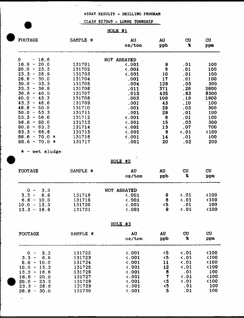
ASSAY RESULTS
The hole locations, and dip angles, are as shown on the
attached drawing, Figure III.
Assay results are summarized in Table I. All samples were
assayed for Au and Cu. The best assay was from hole #1,
drilled directly under the showing in trench #2, in the 3.4'
interval from 36.6' to 40.0' which assayed 435 ppb Au (.013
oz/ton) and 8,300 ppm Cu f.83%).
RECOMMENDATIONS AND CONCLUSIONS
The limited drilling and stripping program indicated the
showing was very limited both laterally and to depth. It is
recommended that no further work is warranted at this time
and that the option on the property be allowed to lapse.
L. J. Bardswich, P. Eng.
lf
J
J-ffiTO
3o
m
POST-
^^
\\
•,\\N \\\\ \
V\
\
ft/LeQ
/--^( N
\ ' \
0 fi A z/j.
OF DAII.L Hot.cs
-3 l 4 TU/P.
c H ; y o ^ e f T
FOOTAGE
01620232630333640434650535660636666
-.6 -.0 -o
.6 -
.0 -
.3 -
.6 -
.0 -
.3 -
.6 -
.0 -
.3 -
.6 -
.0 -
.3 -
.6 -
.6 -
16.20.23.26.30.33.36.40.43.46.50.53.56.60.63.66.70.70.
603603603603603600
**
* - wet sludge
ASSAY RESULTS - DRILLING PROGRAM
CLAIM 827049 - LORNE TOWNSHIP
SAMPLE #
131701131702131703131704131705131706131707131708131709131710131711131712131713131714131715131716131717
HOLE #1
AU o z /t on
NOT ASSAYED< .001< . 001^001.001.004.011.013.003.001.001.001
^001^001^001^001^001.001
AU PPb
99
1017
1283714351064329288
15138
1420
CU
.01
.01
.01
.01
.03
.26
.83
.19
.10
.03
.01
.01
.03
.07K. 01.01.02
CU PPm
100100100100300
260083001900100300100100300700aoo100200
HOLE #2
FOOTAGE
0 -3.3 -6.6 -
10.0 -13.3 -
3.36.6
10.013.316.6
SAMPLE 1* AU oz X ton
AU PPb
CU CU ppm
NOT ASSAYED131718131719131720131721
< . 001^001< . 001^001
68
K59
<.01^01.01^01
aooaoo100aoo
HOLE S3
FOOTAGE
O3.3 6.6
10.0 13.3 16.6 20.0 23.3 26.6
3.36.6
10.013.316.620.023.326.630.0
SAMPLE
131722131723131724131725131726131727131728131729131730
AU oz/ton
001.001.001.001.001.001.001.001
AU ppb
1112
87
CU
^001
.01
.01
.01
.01
.01
.01
.01
.01
.01
CU ppm
aooaooaoo
100aooaoo100100
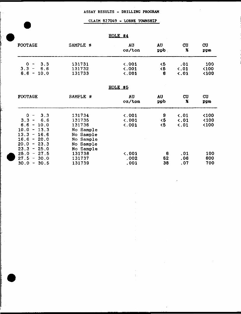
ASSAY RESULTS - DRILLING PROGRAM
CLAIM 827049 - LORNE TOWNSHIP
FOOTAGE
O - 3.3 3.3 - 6.6 6.6 - 10.0
FOOTAGE
03.36.6
10.013.316.620.023.325.027.530.0
- 3.3- 6.6- 10.0- 13.3- 16.6-20.0- 23.3- 25.0-27.5-30.0-30.5
SAMPLE #
131731131732131733
SAMPLE #
131734131735131736No SampleNo SampleNo SampleNo SampleNo Sample131738131737131739
HOLE 114
AUoz/ton
^001^001^001
HOLE *5
AUoz/tpn
K. 001^001^001
^001.002.001
AU CUppb X
<5 .01^ <.016 < . 01
AU CUppb X
9 < .01<5 ^01<5 <.01
6 .0162 .0638 .07
CUppm
100aooaoo
CUppm
UOO<100<100
100600700
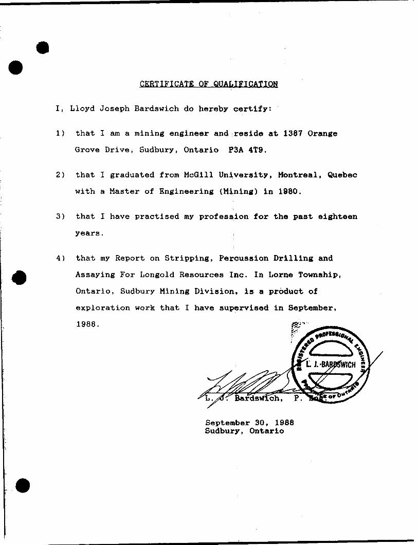
CERTIFICATE OF QUALIFICATION
I, Lloyd Joseph Bardswich do hereby certify:
1) that I am a mining engineer and reside at 1387 Orange
Grove Drive, Sudbury, Ontario P3A 4T9.
2) that I graduated from McGill University, Montreal, Quebec
with a Master of Engineering (Mining) in 1980.
3) that I have practised my profession for the past eighteen
years,
4) that my Report on Stripping, Percussion Drilling and
Assaying For Longold Resources Inc. In Lorne Township,
Ontario, Sudbury Mining Division, is a product of
exploration work that I have supervised in September,
1988.
September 30, 1988 Sudbury, Ontario
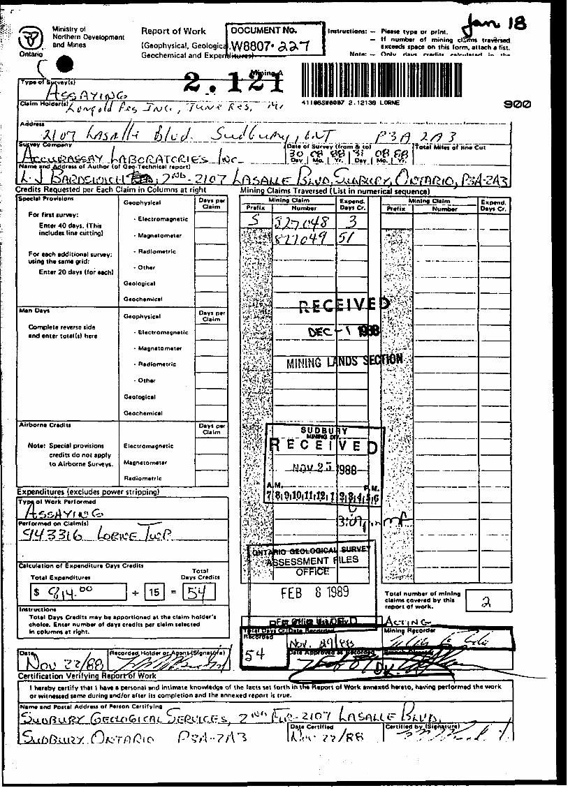
OntariocMinistry ol Northern Development and Mines
Report of Work
(Geophysical, Geologic:Geochemical and Evnpn
DOCUMENT NO.
•W8807- a a tj.i..... i ————— 1
Instructions: - Please type or print. H number of mining clSms traversed
exceeds space on this form, attach a list.
Su veyls)
r -6^ fly r tp 6*- 3.121*ii86swee97 2.12139 LORNE 900
Addreir 07...
Name and Address of Author (of Geo-Tecnnical report)-"Jbme an
- J
U 6 '^L t-ld *1Jidate of Survey (from ft iol ^. |f olal'Miies of line Cut\3o,ce "' '
Day Mo
?-"Jb -2,o7Credits Requested per Each Claim in Columns at rightSpecial Provlf iom
For first turvey:
Enter 40 days. (This includes line cutting)
For each additional survey: using the same grid:
Enter 20 days (for each)
Man Days
Complete reverse side and enter total (t) here
Airborne Credit!
Note: Special provisions credits do not apply to Airborne Surveys.
Geophysical
- Electromagnetic
- Magnetometer
- Radiometric
- Other
Geological
Geochemical
Geophysical
* Electromagnetic
- Magnetometer
- Radiometric
- Other
Geological
Geochemical
Electromagnetic
Magnetometer
Radiometric
Days per Claim
Days per Claim
Days per Claim
Expenditures (excludes power stripping)
Mining Claims Traversed (List in numerical sequence)
Type of Work Performed
fiS.4 Y. KS G?Performed on Claim(s)
Calculation of Expenditure Days Credits
Total ExpendituresTotal
Days Credits
sInstructions
Total Days Credits may b* apportioned at the claim holder's choice. Enter number of days credits per claim selected In columns at right.
Expend. Days Cr.
Expend. Days Cr.
^ 3SESSMENT
FEB 8 1989 Total number of mining claims covered by this report of work.
Recorded. Holder OLAgonMStgnat&r'a}'' (Z, J -**-**Jf7'iiCertification Verifying Reporrof Work
l hereby certify that l have a personal and intimate knowledge of the facts set forth in the Report of Work annexed hereto, having performed the work or witnessed same during and/or after its completion and the annexed report is true.
Name and Postal Address of Person Certifying
Data Certified Certified byied byJSIghaturell xX S ' 7
ttttS Y-
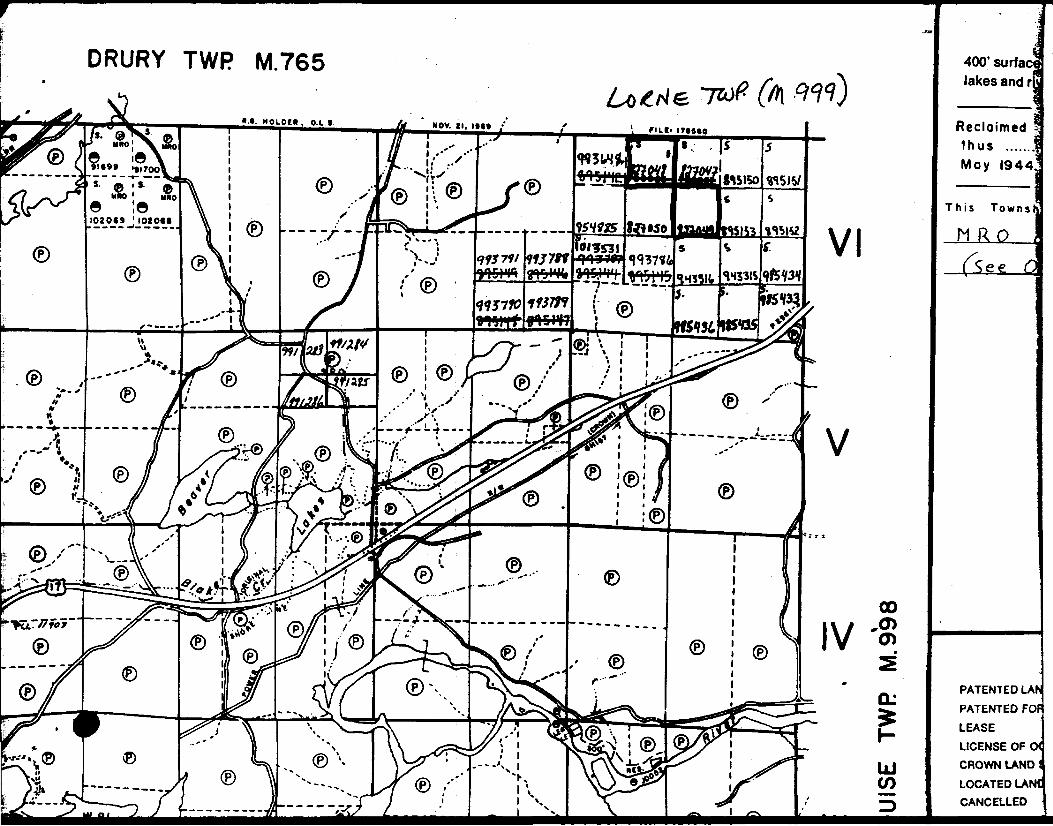
DRURY TWP M.765 400' surf ac lakes and i
• •*. MOIOC*. O.L.I Reclaimed thus May 1944
e ;e1020(9 '1020*1
This Towns
M RO
PATENTED LA*
PATENTED FO
LEASE
LICENSE OF
CROWN LAND
LOCATED LA CANCELLED
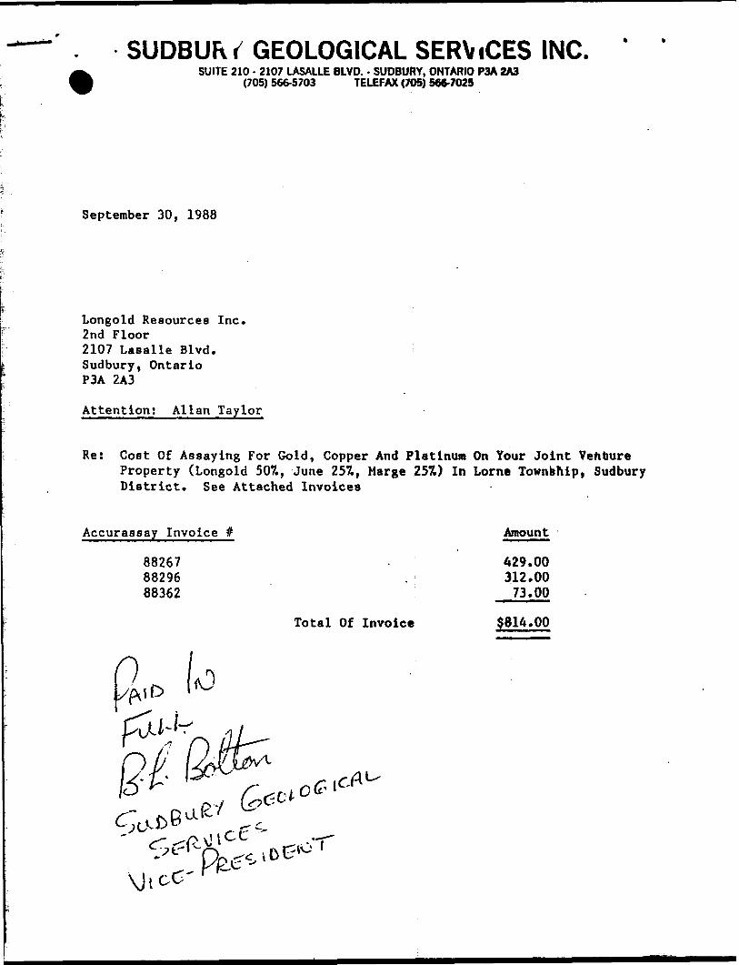
SUDBUR r GEOLOGICAL SERViCES INC.SUITE 210 - 2107 LASALLE BLVD. - SUDBURY, ONTARIO P3A 2A3
(705) 566-5703 TELEFAX (705) 566-7025
September 30, 1988
Longold Resources Inc. 2nd Floor 2107 Lasalle Blvd. Sudbury, Ontario P3A 2A3
Attention! Allan Taylor
Re: Cost Of Assaying For Gold, Copper And Platinum On Your Joint Venture Property (Longold 507., June 257., Marge 25ft) In Lorne Township, Sudbury District. See Attached Invoices
Accurassay Invoice # Amount
88267 . 429.0088296 . 312.0088362 73.00
Total Of Invoice $814.00

NAI
RN
TW
P M
.883
o
;o (D
Ol
LOU
ISE
TW
P M
.998
z o re O
;o -n
Z
~
m Crt O ci TO O
rn
t/*
CO
CO
CO
s rn H
^
CO
2 i-S
- o
tjo
o
DOS
ici
55
Tl
j^
O 2
m
C og H
X
O 10H
O Z
C/
) x "D
O Tl
m
(O a. O 3
. 5
-5
w
'm
m
z C/J O m 3
O 5 en
Oo
c
3 m *
m
o
m
i .
•t- r
r-. •\ o
H c
S
o "K 5
H
o C
-^ o
^
3o
A
O.
•o o
o
o
Z
A10
** (D m
w ST
OD A
O
II w
wtt
C
3
5,Q
. Q
}-*
- O (O CA
(D m 6' e. o ffi ea O 3 w
l m CO