royalle fact sheet 20150617 d
TRANSCRIPT
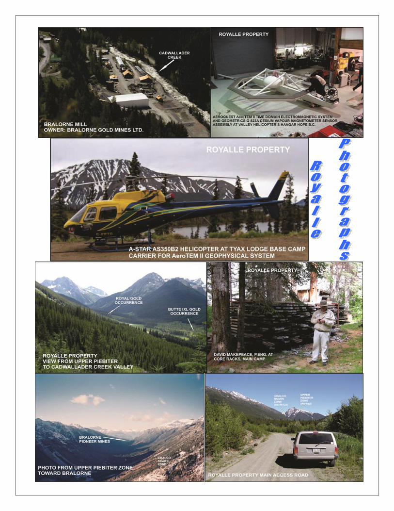
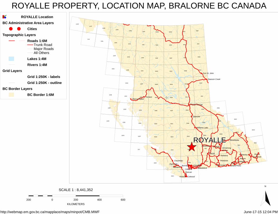
Location Located 175 km north of Vancouver and thirteen kilometers southeast of Bralorne, British
Columbia, Canada - the Province's largest and most famous gold mining camp. Access The Property is accessible by travelling south from Gold Bridge on the main Gold Bridge-
Bralorne road for 5.5 km; thence by Kingman Lake Main logging road southeast along the north side of Cadwallader Creek for 19 km.
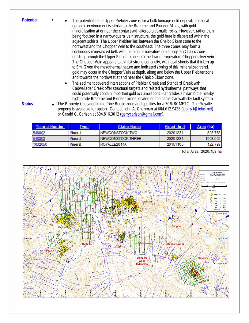
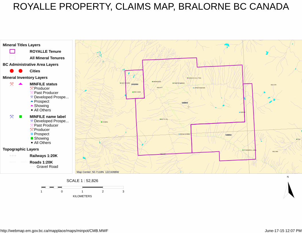
Land Package Three contiguous MTO mineral claims covering 2,620 hectares in the Lillooet Mining Division. Ownership John A. Chapman (50%) and KGE Management Ltd. (50%). Gerald G. Carlson is the President
and major shareholder of KGE Management Ltd. Completed Exploration
Gold was first discovered in the Bridge River-Anderson Lake Gold District as placer in 1863 and in lode vein deposits in 1897. Total production from high-grade veins in the district has exceeded 4.2 million ounces of gold - making the District the largest gold producer in B.C.'s history and also the largest in the Canadian Cordillera.
First recorded work on the Royalle property (aka Piebiter) was in the early 1930’s when an adit reportedly contained a 21 m width of 4.3 g/tonne gold, with samples from trenching and various adits grading up to 8 oz/ton gold.
In 1943, the Chalco/Lower Piebiter tungsten-copper zone was discovered. Drill testing for tungsten occurred in 1969 (Union Carbide Corporation) and again in 1979-80 and resulted in a reported "reserve" of 32,000 tons grading ~1% WO3.
In the early 1980’s, the Chopper silver vein was discovered, with a strike length of 2,400 m and selected grab samples up to 1,585 g/tonne silver.
During 1981 to 1991, Hudson Bay Exploration and Development, Teck Exploration Ltd., Cogema Canada Ltd., and Du Pont of Canada Exploration Limited carried out mapping and sampling for gold (see Assessment Reports at BCGSB); Armeno Resources Inc. and Trans Atlantic Resources Inc. (“Armeno Group”) acquired the Property and completed extensive geological, geophysical and geochemical surveys.
1986-88: Armeno Group completed 6,368 m of core drilling and 139 m of underground development. Four target zones were explored – Piebiter, Chopper, Standard and Chalco. On the Upper Piebiter zone, drilling outlined a zone 15 to 35 m wide, 150 m deep and potentially in excess of 600 m strike length. Gold values of up to 2.01 g/tonne gold over 9 m and 4.77 g/tonne gold over 1.5 m were reported.
1989-90: An IP survey and 1,286 m of reverse circulation drilling was completed during the early winter months and gold values reported confirmed and extended the 1986-88 core drilling on the Upper Piebiter zone.
Allen, Brownlee and MacQuarrie reported in Assessment Report 15871, "data from the Royal grid suggests a porphyry type exploration target, perhaps a porphyry molybdenum deposit with peripheral or telescoped lead-zinc-precious metal mineralization". The related geochemical map shows elevated molybdenum in soils (>=10ppm) over an area 1,600 meters long and 600 meters wide near the junction of Cadwallader Creek and Standard Creek (NE of junction).
Covenant Resources Ltd. optioned the Property in 2007 and in 2008 commissioned Aeroquest International Limited to complete a 320 line km AeroTEM II helicopter-borne geophysical survey over the Property (Job #08062). Several EM and Magnetic anomalies were defined. In 2009 Covenant commissioned C.J. Greig and Associates Ltd. to complete a digital data compilation of historical soil sampling, geological mapping and drilling on and near the historical Piebiter, Royal, Standard, Butte-IXL, Chalco and Red Hawk MinFile
areas. The maps generated targets for IP and for drilling, and formed part of an updated NI 43-101 Report. Covenant relinquished their option on the Property in early 2010.
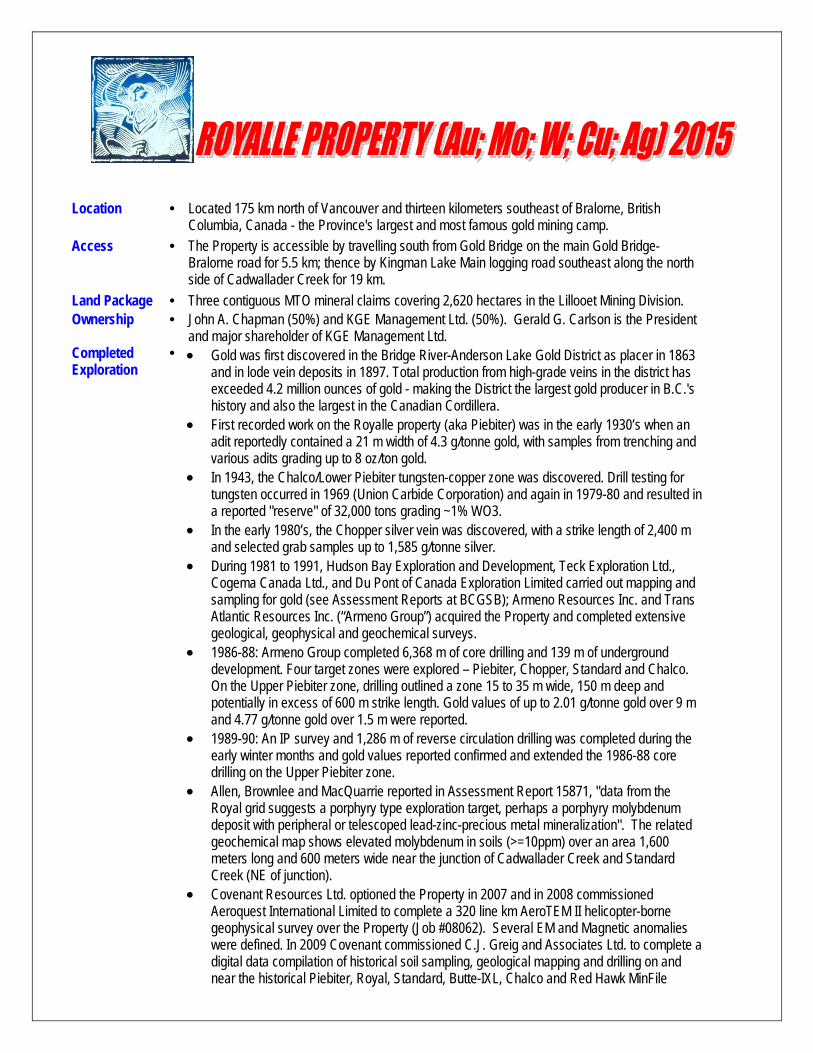
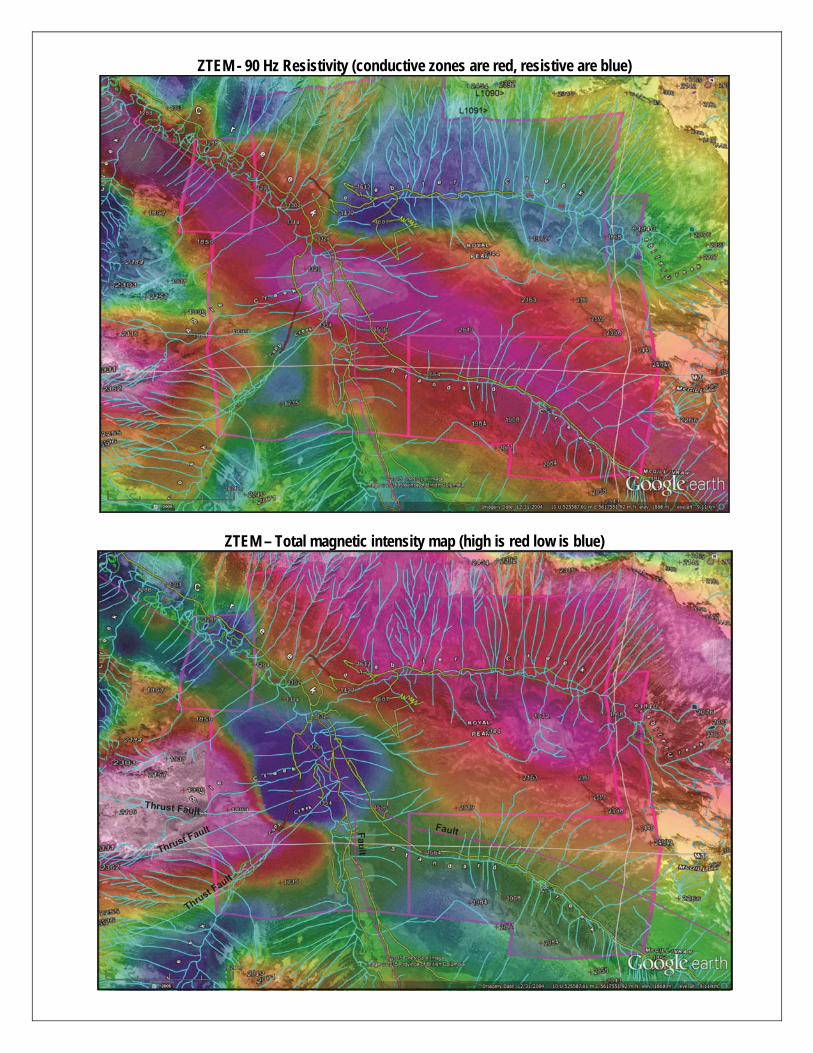
Worthington Resources Ltd. optioned the Property in October 2010 and, in May 2011, contracted Geotech Ltd. to fly a ZTEM geophysical survey over the Property. ZTEM is an airborne geophysical technique used for distinguishing conductivity contrasts within the upper earth’s crust, to depths in excess of 1,000 m, and has proven to be an effective tool for mapping large structures and alteration systems, such as those related to porphyry deposits. The Royalle ZTEM survey effectively outlined the northwest-trending Cadwallader break where it transects the Property, as well as a number of north-northwest and wet-northwest cross structures. Carpenter (2012 Royalle Assessment Report) concluded that the ZTEM survey results, combined with earlier AeroTEM and MMI soil geochemical results, can be used to define exploration targets. Key among these would be structural intersections and dilatation zones along major structures.
Resources No resource calculations have been conducted on the Property for gold. However, the Upper Piebiter zone (gold) and the Chalco Skarn zone (copper & tungsten) are advanced enough that they could be modeled and a resource calculated. The Upper Piebiter gold deposit is located between 1,500 meters and 1,900 meters elevation along the south side of Piebiter Creek, with road access from the main Piebiter road. The Chalco Skarn deposit is located at 1,615masl on the north side of Piebiter Creek near its confluence with Cadwallader Creek. There is road access to the deposit from the main Piebiter road.
Area Production
At 1971, when production ceased, the Bralorne-Pioneer was the most prolific gold camp in British Columbia and retains that record to this date. The production is summarized below: Mine Period Production (tons) Gold Grade (oz/ton) Bralorne 1932-1971 5,474,000 0.52 Pioneer 1914-1962 2,477,000 0.54 Minto 1934-1940 89,000 0.20 Wayside 1915-1937 43,000 0.13 Bralorne Gold Mines Ltd. is currently developing the unexplored gaps between the historic Bralorne, King and Pioneer gold mines. Together, these three historic mines represent the largest historic gold producer in the Canadian Cordillera producing 4.1 million ounces of gold. Recent discoveries between the Bralorne and King mines have opened up significant new mineralization. Phase III exploration, now underway, is focused on expanding new zones and outlining reserves for a 280 tpd operation. The current Bralorne mill operates at 120 tpd with ample room for expansion. Bulk testing is complete with all permits in place.
Geology The Property lies along the southeast extension of a major gold-bearing structure, the Cadwallader break, a part of the regional Bralorne fault system. The oldest rocks in the area belong to the Pre-Permian Fergusson Group chert with some marble, schist, gneiss and hornfels, cut by younger greenstone. These are overlain by the Upper Triassic Cadwallader Group, consisting of greenstone (mafic volcanics), overlain by argillite and siltstone with local limestone and coarser clastic rocks. The Jurassic Taylor Creek Group consists mainly of coarse clastic sediments, believed to be derived from the Fergusson and Cadwallader Groups. Intrusive rocks include the Paleozoic Bralorne diorite, the Jura-Cretaceous President ultramafic rocks and the Cretaceous Coast Plutonic Complex. The main controls on gold mineralization in the district are the Bralorne-Cadwallader fault zone, proximity to serpentinized alteration and possibly the Bralorne diorite intrusions. Alteration consists of carbonate and pyritization; gold shows a particular association with mariposite-bearing quartz-carbonate rocks (listwanite) along serpentinite contacts.
Environment The Royalle property is located adjacent to the historic Bralorne-Pioneer mining camp in the Bridge River – Anderson Lake Gold District that continues to be explored and operated. In addition, there is ongoing timber harvesting in the region providing good access to several areas on the Property. The area is serviced from the local resource communities of Gold Bridge and Bralorne. The Property is situated in the Bridge River and Anderson Lake watersheds bounded on the west by the Coast Range and on the northeast by the Shulaps Range. The area exhibits typical U-shaped glaciated valleys and ragged ridge-lines.
Potential
The potential in the Upper Piebiter zone is for a bulk tonnage gold deposit. The local geologic environment is similar to the Bralorne and Pioneer Mines, with gold mineralization at or near the contact with altered ultramafic rocks. However, rather than being focused in a narrow quartz vein structure, the gold here is dispersed within the adjacent schists. The Upper Piebiter lies between the Chalco Skarn zone to the northwest and the Chopper Vein to the southeast. The three zones may form a continuous mineralized belt, with the high temperature gold-tungsten Chalco zone grading through the Upper Piebiter zone into the lower temperature Chopper silver vein. The Chopper Vein appears to exhibit strong continuity, with local shoots that thicken up to 5m. Given the mesothermal nature and indicated zoning of this mineralized trend, gold may occur in the Chopper Vein at depth, along and below the Upper Piebiter zone and towards the northwest at and near the Chalco Skarn zone.
The sediment covered intersections of Piebiter Creek and Standard Creek with Cadwallader Creek offer structural targets and related hydrothermal pathways that could potentially contain important gold accumulations – at grades similar to the nearby high-grade Bralorne and Pioneer mines located on the same Cadwallader fault system.
Status The Property is located in the Pine Beetle zone and qualifies for a 30% BCMETC. The Royalle property is available for option. Contact John A. Chapman at 604.612.9438 ([email protected]) or Gerald G. Carlson at 604.816.3012 ([email protected]).
ROYALLEROYALLEROYALLEROYALLEROYALLE
Abbotsford
Armstrong
Burnaby
Castlegar
Colwood
Coquitlam
Courtenay
Cranbrook
Dawson Creek
Duncan
Enderby
Fernie
Fort St. John
Grand Forks Greenwood
Kamloops
Kelowna Kimberley
Langley
Merritt
Nanaimo
Nelson
Parksville
Penticton
Prince George
Prince Rupert
Quesnel
Revelstoke
Terrace
Trail
Vernon
Victoria
Williams Lake
082J
082K
082M
082N
082O
092C
092E 092G092H
092I092J092K092L
092M 092N 092O092P
102I
102O102P
083C
083D
083E
093A093B093C093D
093E 093F 093G093H
093I093J093K093L
093M 093N 093O093P
103A103B
103C
103F103G
103H
103I103J
103K
103O103P
094A094B094C094D
094E 094F 094G094H
094I094J094K094L
094M 094N 094O094P
104A104B
104C
104F104G
104H
104I104J
104K104L
104M104N
104O104P
114I
114O
114P
ROYALLE LocationBC Administrative Area Layers
CitiesTopographic Layers
Roads 1:6MTrunk RoadMajor RoadsAll Others
Lakes 1:4MRivers 1:4M
Grid LayersGrid 1:250K - labels Grid 1:250K - outline
BC Border LayersBC Border 1:6M
ROYALLE PROPERTY, LOCATION MAP, BRALORNE BC CANADA
http://webmap.em.gov.bc.ca/mapplace/maps/minpot/CMB.MWF June-17-15 12:04 PM
SCALE 1 : 8,441,352
0200 200 400 600
KILOMETERS
N
Map Center: 50.7118N 122.6398W Map Center: 50.7118N 122.6398W Map Center: 50.7118N 122.6398W Map Center: 50.7118N 122.6398W Map Center: 50.7118N 122.6398W
548802548802548802548802548802
548803548803548803548803548803
10320501032050103205010320501032050
BUTTE-IXL
PIEBITER CREEK
CONBRA
FOX
ROYAL (L.5650)
EMPIRE
UPPER PIEBITER
DAN TUCKER
RED HAWK
STANDARD (L.1940)
CHALCO 12 (L.7702)
BRAMOOSE
092J.077
092J.078
092J.067
092J.068
Mineral Titles LayersROYALLE TenureAll Mineral Tenures
BC Administrative Area LayersCities
Mineral Inventory LayersMINFILE status
Producer Past Producer Developed Prospe...Prospect Showing All Others
MINFILE name labelDeveloped Prospe...Past Producer Producer Prospect Showing All Others
Topographic LayersRailways 1:20KRoads 1:20K
Gravel Road
ROYALLE PROPERTY, CLAIMS MAP, BRALORNE BC CANADA
http://webmap.em.gov.bc.ca/mapplace/maps/minpot/CMB.MWF June-17-15 12:07 PM
SCALE 1 : 52,826
01 1 2 3
KILOMETERS
N
ZTEM - 90 Hz Resistivity (conductive zones are red, resistive are blue)
ZTEM – Total magnetic intensity map (high is red low is blue)