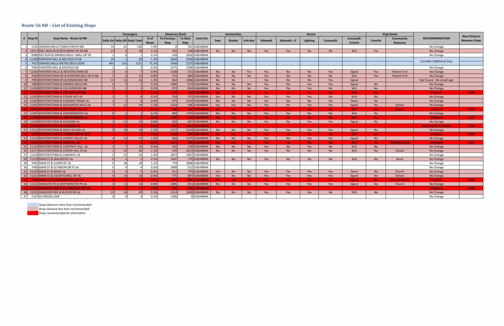
route no. 56 nb summary table · route 56 nb – list of existing stops daily on daily off daily...
TRANSCRIPT

Bus Stop Optimization Pilot 122 August 2014
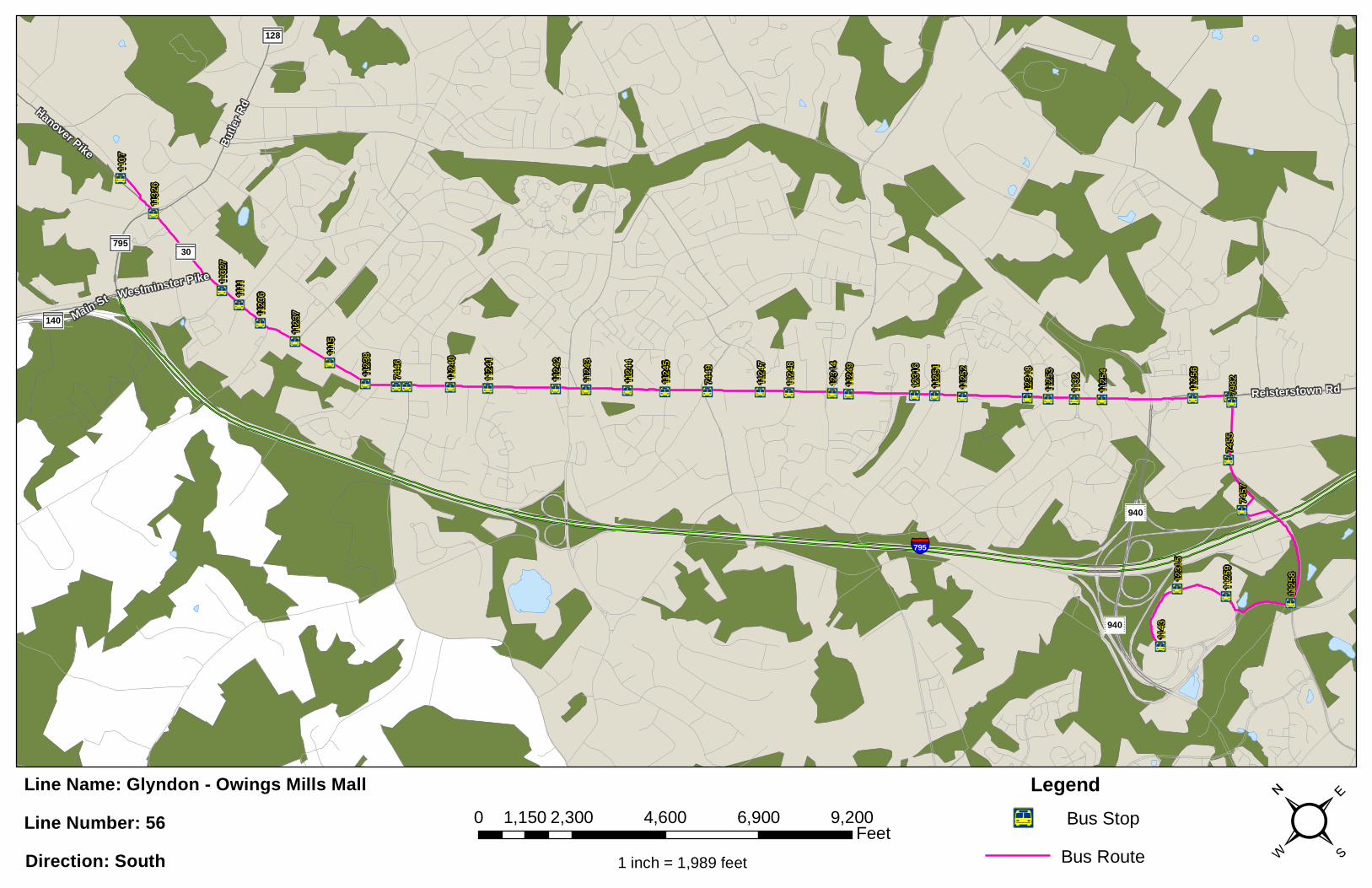
Route No. 56 NB – Summary Table
Route No. 56 NB – Recommended Stops for Elimination
Stop ID
Stop Name - Route 56 NB
Passengers Distances (feet)
Land Use Daily On
Daily Off
Daily Total
% of Route
To Previous
Stop
To Next Stop
11302 REISTERSTOWN RD & TOLLGATE RD OP nb 0 1 1 0.1% 814 534 SUBURBAN
11306 REISTERSTOWN RD & PLEASANT HILL nb 0 1 1 0.1% 596 482 SUBURBAN
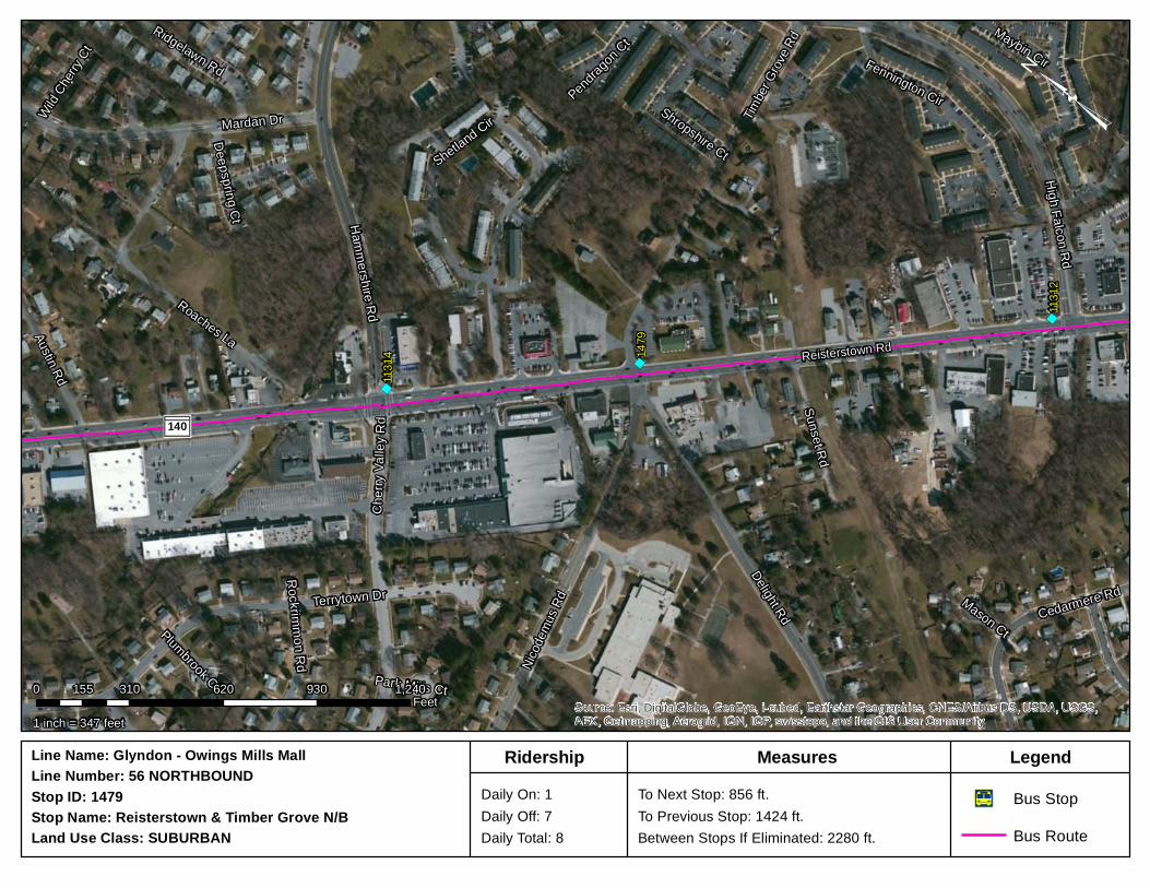
11308 REISTERSTOWN RD & GWYNNBROOK AVE nb 2 4 6 0.4% 1783 362 SUBURBAN
11310 REISTERSTOWN RD & KINGSLEY RD nb 0 0 0 0.0% 667 1127 SUBURBAN
1479 REISTERSTOWN RD & TIMBER GROVE RD N/B 1 7 8 0.5% 1424 856 SUBURBAN
11315 REISTERSTOWN RD & VIRGINA AVE nb 0 3 3 0.2% 1375 582 SUBURBAN
7498 MAIN ST & CHATSWORTH AVE nb 0 2 2 0.1% 897 1085 SUBURBAN
11324 HANOVER PIKE & 63 HANOVER PIKE nb 0 0 0 0.0% 851 1114 SUBURBAN
Based upon field review, there were additional stops encountered on the field that were not included
in the MTA database. Due to lack of information, no information sheets were generated, but the
missing stops are identified below:
- Between Gwynswood Rd and Gwynbrook Ave - Between Highfalcon Rd and Timber Grove Rd - Between Chestnut Hill Ln and Cherry Hill Rd
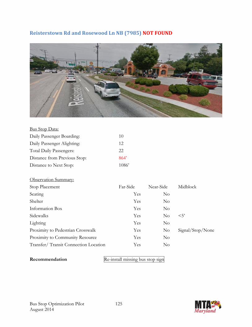
Google Earth shows a bus stop at Reisterstown Rd at Rosewood Ln (stop ID 7985), but it was not
found upon field review. The bus has been seen to stop at that location even without bus stop sign.
It is recommended to re-install bus stop sign at this location.
Please note that this is not an all-encompassing list of unidentified bus stops. These only reflect
stops that were in the vicinity of those stops being field evaluated as per the spacing
recommendation guidelines.

Æa Æa Æa
Æa
Æa
Æa
ÆaÆaÆaÆaÆaÆaÆaÆaÆaÆaÆaÆaÆaÆaÆaÆaÆaÆaÆaÆaÆaÆaÆa
Æa
ÆaÆa
Æa
Æa
Æa
Æa
Æa
1107
7498
7496
7495
1479
7489 7985 7983
7485
7457
83881143
1132
5
1132
4
1132
3
1132
1
1132
0
1131
9
1131
8
1131
7
1131
6
1131
5
1131
4
1131
2
1131
0
1130
911
308
1130
711
306
1130
5
1130
4
1130
3
1130
2
1130
0
1129
8
1231
7
§̈¦795
140
795
940
128
940
Reisterstown Rd
Butle
r RdHanover Pike
Main St
Main StMain St
²Line Name: Glyndon - Owings Mills MallLine Number: 56Direction: North Bus Route
Æa Bus StopLegend
1 inch = 1,989 feet
0 2,300 4,600 6,900 9,2001,150 Feet
Route56NB–ListofExistingStops
Daily On Daily Off Daily Total% of
Route
To Previous
Stop
To Next
StopSeat Shelter Info Box Sidewalk Sidewalk > 5' Lighting Crosswalk
Crosswalk
ControlTransfer
Community
Resource
1 1143 OWINGS MILLS TOWN CENTER WB 74 61 135 7.9% 0 701 SUBURBAN No Change2 12317 MILL RUN CR & RESTURANT PK DR NB 13 5 18 1.1% 701 558 SUBURBAN No No No Yes Yes No No N/A Yes No Change3 8388 RED RUN & OWINGS MILLS MALL OP EB 1 0 1 0.1% 558 2626 SUBURBAN No Change4 11298 PAINTERS MILL & RED RUN FS EB 19 1 20 1.2% 2626 3560 SUBURBAN5 7457 OWINGS MILLS METRO (BUS LOOP) 695 516 1211 71.2% 3560 2275 SUBURBAN6 7485 PAINTERS MILL & DOLFIELD EB 2 1 3 0.2% 2275 1348 SUBURBAN No Change7 11260 PAINTERS MILLS & REISTERSTOWN EB 3 4 7 0.4% 1348 371 SUBURBAN No No Yes Yes No No Yes Signal Yes Patient First No Change8 7983 REISTERSTOWN RD & PAINTERS MILL RD fs NB 7 6 13 0.8% 371 864 SUBURBAN No No No Yes No No No N/A Yes Patient First No Change9 7985 REISTERSTOWN RD & ROSEWOOD NB 10 12 22 1.3% 864 1086 SUBURBAN No No Yes No No Yes Signal Not Found ‐ Re‐install sign
10 7489 REISTERSTOWN & OWINGS MILLS NB 0 2 2 0.1% 1086 972 SUBURBAN No No No Yes No Yes Yes Signal No No Change11 11300 REISTERSTOWN & CSX OVERPASS NB 2 1 3 0.2% 972 814 SUBURBAN No No No Yes Yes Yes No N/A No No Change12 11302 REISTERSTOWN & TOLLGATE OP NB 0 1 1 0.1% 814 534 SUBURBAN No No No Yes No Yes No N/A No Eliminate 1348
13 11303 REISTERSTOWN & STRAW HAT nb 1 7 8 0.5% 534 975 SUBURBAN Yes No No Yes Yes Yes No N/A No No Change14 11304 REISTERSTOWN & PLEASANT RIDGE nb 1 5 6 0.4% 975 1343 SUBURBAN No No No No No No Yes None No No Change15 11305 REISTERSTOWN & ENCHANTED HILLS nb 7 12 19 1.1% 1343 596 SUBURBAN Yes Yes No Yes No Yes Yes Signal No School No Change16 11306 REISTERSTOWN & PLEASANT HILL nb 0 1 1 0.1% 596 482 SUBURBAN No No No Yes No Yes No N/A No Church Eliminate 1078
17 11307 REISTERSTOWN & GWYNNSWOOD nb 0 2 2 0.1% 482 1783 SUBURBAN No No No Yes Yes No No N/A No No Change18 11308 REISTERSTOWN & GWYNNBROOK nb 2 4 6 0.4% 1783 362 SUBURBAN No No No Yes No No No N/A No Eliminate 2145
19 11309 REISTERSTOWN & RICHMAR nb 2 12 14 0.8% 362 667 SUBURBAN No No No Yes No Yes Yes Signal No No Change20 11310 REISTERSTOWN & KINGSLEY nb 0 0 0 0.0% 667 1127 SUBURBAN Not Found/ Eliminate 1794
21 11312 REISTERSTOWN & HIGH FALCON nb 0 18 18 1.1% 1127 1424 SUBURBAN No No No Yes Yes Yes Yes Signal No No Change22 1479 REISTERSTOWN & TIMBER GROVE N/B 1 7 8 0.5% 1424 856 SUBURBAN No No No Yes No Yes No N/A No Eliminate 2280
23 11314 REISTERSTOWN & CHERRY VALLEY nb 4 13 17 1.0% 856 1375 SUBURBAN No No No Yes No Yes Yes Signal No No Change24 11315 REISTERSTOWN & VIRGINA nb 0 3 3 0.2% 1375 582 SUBURBAN No No No Yes Yes No No N/A No Medical Center Eliminate 1957
25 11316 REISTERSTOWN & CHESTNUT HILL nb 3 7 10 0.6% 582 539 SUBURBAN No No No Yes No Yes No N/A No No Change26 11317 REISTERSTOWN & CHERRY HILL FS nb 1 35 36 2.1% 539 1872 SUBURBAN No No No Yes No No No N/A No School No Change27 11318 REISTERSTOWN & CARAWAY nb 2 22 24 1.4% 1872 1467 SUBURBAN No Change28 11319 MAIN ST & WALGROVE nb 0 2 2 0.1% 1467 774 SUBURBAN No No No Yes No No No N/A No None No Change29 7495 MAIN ST & CHARTLEY nb 0 18 18 1.1% 774 1898 SUBURBAN No Change30 7496 MAIN ST & GLYNDON DR FS nb 0 4 4 0.2% 1898 912 SUBURBAN No Change31 11320 MAIN ST & BOND nb 0 5 5 0.3% 912 775 SUBURBAN Yes No No Yes Yes Yes Yes None No Church No Change32 11321 MAIN ST & COCKEYS MILL OP nb 0 10 10 0.6% 775 897 SUBURBAN Yes No No Yes Yes Yes Yes Signal No School No Change33 7498 MAIN ST & CHATSWORTH AVE nb 0 2 2 0.1% 897 1085 SUBURBAN No No No Yes Yes Yes Yes Signal No Church/ School Eliminate 1982
34 11323 HANOVER PK & WESTMINSTER PK nb 3 11 14 0.8% 1085 851 SUBURBAN No No No Yes Yes Yes Yes Signal No Church No Change35 11324 HANOVER PIKE & 63 HANOVER PIKE nb 0 0 0 0.0% 851 1114 SUBURBAN Eliminate 1965
36 11325 HANOVER PIKE & BUTLER RD nb 21 14 35 2.1% 1114 1300 SUBURBAN No No No Yes Yes Yes No N/A No No Change37 1107 GLYNDON LOOP 4 0 4 0.2% 1300 0 SUBURBAN No Change
Stops distance more than recommendedStops distance less than recommendedStops recommended for elimination
Ammenities
Land Use# Stop ID Stop Name ‐ Route 56 NB
Passengers Distances (feet)
Consider Additional Stop
Access Stop Detail
RECOMMENDATIONNew Distance
Between Stops
Bus Stop Optimization Pilot 125 August 2014
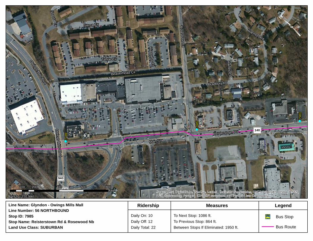
Reisterstown Rd and Rosewood Ln NB (7985) NOT FOUND
Bus Stop Data:
Daily Passenger Boarding: 10
Daily Passenger Alighting: 12
Total Daily Passengers: 22
Distance from Previous Stop: 864’
Distance to Next Stop: 1086’
Observation Summary:
Stop Placement Far-Side Near-Side Midblock
Seating Yes No
Shelter Yes No
Information Box Yes No
Sidewalks Yes No <5’
Lighting Yes No
Proximity to Pedestrian Crosswalk Yes No Signal/Stop/None
Proximity to Community Resource Yes No
Transfer/ Transit Connection Location Yes No
Recommendation Re-install missing bus stop sign
")
")
")74
89
7985
7983
140
940
940
Reisterstown Rd
Main St
Bradbury Rd
Rosewood La
Owings Mills Blvd
Beaverhead Cir
Tahoe Cir
Sierra CirHarmon Rd
Haines Ct
Hiawatha Ct
Shasta Cir
Owings Mills Blvd
Source: Esri, DigitalGlobe, GeoEye, i-cubed, Earthstar Geographics, CNES/Airbus DS, USDA, USGS,AEX, Getmapping, Aerogrid, IGN, IGP, swisstopo, and the GIS User Community
³
1 inch = 232 feet
0 200 400 600 800100Feet
Stop Name: Reisterstown Rd & Rosewood NbStop ID: 7985 Daily On: 10
Daily Off: 12Daily Total: 22
To Next Stop: 1086 ft.To Previous Stop: 864 ft.Between Stops If Eliminated: 1950 ft.
Line Name: Glyndon - Owings Mills MallLine Number: 56 NORTHBOUND
Bus RouteÆa Bus Stop
Land Use Class: SUBURBAN
LegendMeasuresRidership

Bus Stop Optimization Pilot 127 August 2014
Reisterstown Rd and Tollgate Rd NB (11302)
Bus Stop Data:
Daily Passenger Boarding: 0
Daily Passenger Alighting: 1
Total Daily Passengers: 1
Distance from Previous Stop: 814’
Distance to Next Stop: 534’
Observation Summary:
Stop Placement Far-Side Near-Side Midblock
Seating Yes No
Shelter Yes No
Information Box Yes No
Sidewalks Yes No <5’
Lighting Yes No
Proximity to Pedestrian Crosswalk Yes No Signal/Stop/None
Proximity to Community Resource Yes No
Transfer/ Transit Connection Location Yes No
Recommendation No Change Eliminate
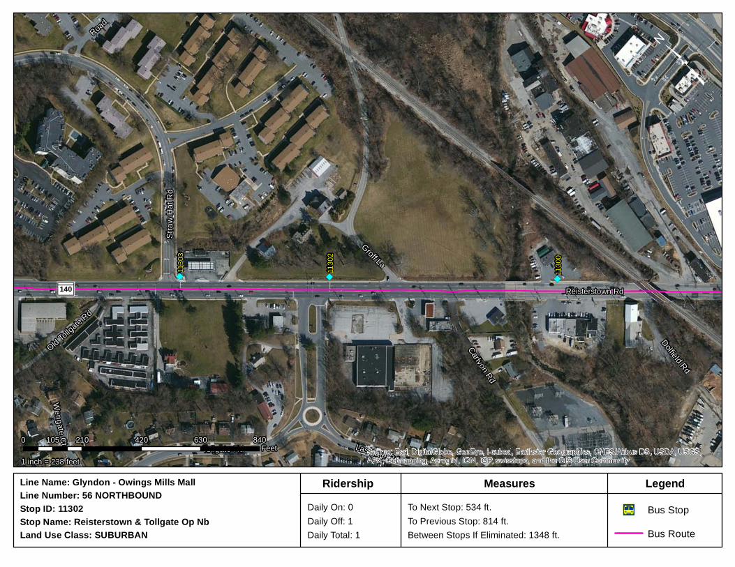
")")")11
303
1130
2
1130
0
140 Reisterstown Rd
Groff La
Straw
Hat
Rd
Tollgate Rd Lastgate Rd
Carlvon Rd
Dolfield Rd
Old Tollgate Rd
Road
Wengate Ct
Source: Esri, DigitalGlobe, GeoEye, i-cubed, Earthstar Geographics, CNES/Airbus DS, USDA, USGS,AEX, Getmapping, Aerogrid, IGN, IGP, swisstopo, and the GIS User Community
³
1 inch = 238 feet
0 210 420 630 840105Feet
Stop Name: Reisterstown & Tollgate Op NbStop ID: 11302 Daily On: 0
Daily Off: 1Daily Total: 1
To Next Stop: 534 ft.To Previous Stop: 814 ft.Between Stops If Eliminated: 1348 ft.
Line Name: Glyndon - Owings Mills MallLine Number: 56 NORTHBOUND
Bus RouteÆa Bus Stop
Land Use Class: SUBURBAN
LegendMeasuresRidership

Bus Stop Optimization Pilot 129 August 2014
Reisterstown Rd and Pleasant Hill Rd NB (11306)
Bus Stop Data:
Daily Passenger Boarding: 0
Daily Passenger Alighting: 1
Total Daily Passengers: 1
Distance from Previous Stop: 596’
Distance to Next Stop: 482’
Observation Summary:
Stop Placement Far-Side Near-Side Midblock
Seating Yes No
Shelter Yes No
Information Box Yes No
Sidewalks Yes No <5’
Lighting Yes No
Proximity to Pedestrian Crosswalk Yes No Signal/Stop/None
Proximity to Community Resource Yes No Pleasant Hills United
Methodist Church
Transfer/ Transit Connection Location Yes No
Recommendation No Change Eliminate

")
")
")11
307
1130
6 1130
5
140Reisterstown Rd
Road
Ritter
s La
Gwynnswood Rd
Summerwoods Way
Hunt Cliff Dr
Ench
anted
Hills
Rd
Pleasa
nt Hil
l Rd
Gentlebrook Rd
Pleas
ant H
ill Rd E
Huntr
idge D
r
Brigh
t Sky
Ct
Gentl
ebroo
k Rd
Source: Esri, DigitalGlobe, GeoEye, i-cubed, Earthstar Geographics, CNES/Airbus DS, USDA, USGS,AEX, Getmapping, Aerogrid, IGN, IGP, swisstopo, and the GIS User Community
³
1 inch = 283 feet
0 250 500 750 1,000125Feet
Stop Name: Reisterstown & Pleasant Hill NbStop ID: 11306 Daily On: 0
Daily Off: 1Daily Total: 1
To Next Stop: 482 ft.To Previous Stop: 596 ft.Between Stops If Eliminated: 1078 ft.
Line Name: Glyndon - Owings Mills MallLine Number: 56 NORTHBOUND
Bus RouteÆa Bus Stop
Land Use Class: SUBURBAN
LegendMeasuresRidership
Bus Stop Optimization Pilot 131 August 2014
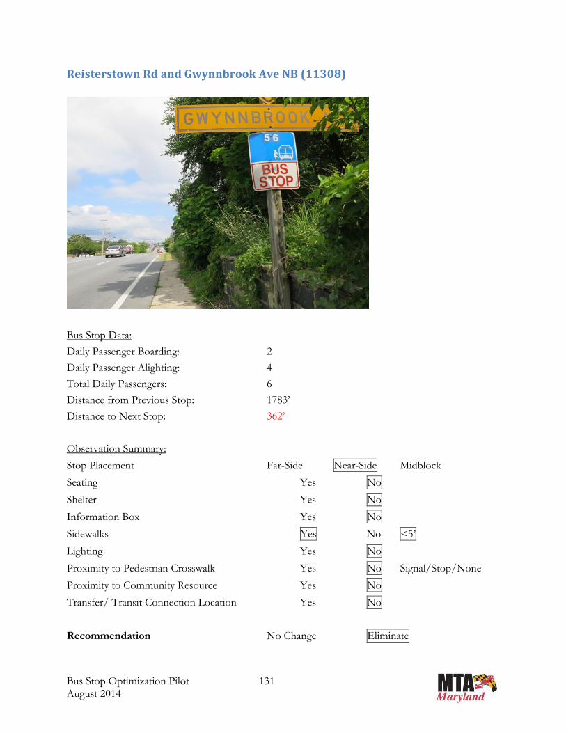
Reisterstown Rd and Gwynnbrook Ave NB (11308)
Bus Stop Data:
Daily Passenger Boarding: 2
Daily Passenger Alighting: 4
Total Daily Passengers: 6
Distance from Previous Stop: 1783’
Distance to Next Stop: 362’
Observation Summary:
Stop Placement Far-Side Near-Side Midblock
Seating Yes No
Shelter Yes No
Information Box Yes No
Sidewalks Yes No <5’
Lighting Yes No
Proximity to Pedestrian Crosswalk Yes No Signal/Stop/None
Proximity to Community Resource Yes No
Transfer/ Transit Connection Location Yes No
Recommendation No Change Eliminate

")
")")11
309
1130
8
1130
7
140 Reisterstown Rd
Walk AveRic
h Mar
Rd
Gentl
ebroo
k Rd
Pleasa
nt Hil
l Rd
Gwyn
nbroo
k Ave
Dolfield Blvd Doemeadow RdSu
mmerw
oods
Way
Hidde
ncree
k Ct
Hollowbrook Rd
Wildbranch Ct
Source: Esri, DigitalGlobe, GeoEye, i-cubed, Earthstar Geographics, CNES/Airbus DS, USDA, USGS,AEX, Getmapping, Aerogrid, IGN, IGP, swisstopo, and the GIS User Community
³
1 inch = 283 feet
0 250 500 750 1,000125Feet
Stop Name: Reisterstown & Gwynnbrook NbStop ID: 11308 Daily On: 2
Daily Off: 4Daily Total: 6
To Next Stop: 362 ft.To Previous Stop: 1783 ft.Between Stops If Eliminated: 2145 ft.
Line Name: Glyndon - Owings Mills MallLine Number: 56 NORTHBOUND
Bus RouteÆa Bus Stop
Land Use Class: SUBURBAN
LegendMeasuresRidership

Bus Stop Optimization Pilot 133 August 2014
Reisterstown Rd and Kingsley Rd NB (11310) NOT FOUND
Bus Stop Data:
Daily Passenger Boarding: 0
Daily Passenger Alighting: 0
Total Daily Passengers: 0
Distance from Previous Stop: 667’
Distance to Next Stop: 1127’
Observation Summary:
Stop Placement Far-Side Near-Side Midblock
Seating Yes No
Shelter Yes No
Information Box Yes No
Sidewalks Yes No <5’
Lighting Yes No
Proximity to Pedestrian Crosswalk Yes No Signal/Stop/None
Proximity to Community Resource Yes No
Transfer/ Transit Connection Location Yes No
Recommendation Not Found - Eliminate

")
")
")11
312 11
310 1130
9
140 Reisterstown RdKingsley Rd
Ceda
rmere
Rd
Rich M
ar Rd
High Falcon Rd
Fennington Cir
Sunset Rd
Dolfield Blvd
Meriam Ct
Maybin Cir
Ashmere RdSource: Esri, DigitalGlobe, GeoEye, i-cubed, Earthstar Geographics, CNES/Airbus DS, USDA, USGS,AEX, Getmapping, Aerogrid, IGN, IGP, swisstopo, and the GIS User Community
³
1 inch = 274 feet
0 240 480 720 960120Feet
Stop Name: Reisterstown & Kinsley NbStop ID: 11310 Daily On: 0
Daily Off: 0Daily Total: 0
To Next Stop: 1127 ft.To Previous Stop: 667 ft.Between Stops If Eliminated: 1794 ft.
Line Name: Glyndon - Owings Mills MallLine Number: 56 NORTHBOUND
Bus RouteÆa Bus Stop
Land Use Class: SUBURBAN
LegendMeasuresRidership

Bus Stop Optimization Pilot 135 August 2014
Reisterstown Rd and Timber Grove Rd NB (1479)
Bus Stop Data:
Daily Passenger Boarding: 1
Daily Passenger Alighting: 7
Total Daily Passengers: 8
Distance from Previous Stop: 1424’
Distance to Next Stop: 856’
Observation Summary:
Stop Placement Far-Side Near-Side Midblock
Seating Yes No
Shelter Yes No
Information Box Yes No
Sidewalks Yes No <5’
Lighting Yes No
Proximity to Pedestrian Crosswalk Yes No Signal/Stop/None
Proximity to Community Resource Yes No
Transfer/ Transit Connection Location Yes No
Recommendation No Change Eliminate
")
")
")
1479
1131
4
1131
2
140
Reisterstown Rd
Terrytown Dr
Delight Rd
Mardan Dr
Nicod
emus
Rd
Timbe
r Grov
e Rd
Hammershire RdRoaches La
High Falcon Rd
Cherr
y Vall
ey R
d
Fennington Cir
Austin Rd
Sunset Rd
Cedarmere Rd
Shetland Cir
Maybin Cir
Ridgelawn Rd
Rockrimmon Rd
Shropshire Ct
Deepspring Ct
Pendrag
on Ct
Wild Ch
erry C
t
Mason CtPlumbrook Ct Park Mills CtSource: Esri, DigitalGlobe, GeoEye, i-cubed, Earthstar Geographics, CNES/Airbus DS, USDA, USGS,AEX, Getmapping, Aerogrid, IGN, IGP, swisstopo, and the GIS User Community
³
1 inch = 347 feet
0 310 620 930 1,240155Feet
Stop Name: Reisterstown & Timber Grove N/BStop ID: 1479 Daily On: 1
Daily Off: 7Daily Total: 8
To Next Stop: 856 ft.To Previous Stop: 1424 ft.Between Stops If Eliminated: 2280 ft.
Line Name: Glyndon - Owings Mills MallLine Number: 56 NORTHBOUND
Bus RouteÆa Bus Stop
Land Use Class: SUBURBAN
LegendMeasuresRidership

Bus Stop Optimization Pilot 137 August 2014
Reisterstown Rd and Virginia Ave NB (11315)
Bus Stop Data:
Daily Passenger Boarding: 0
Daily Passenger Alighting: 3
Total Daily Passengers: 3
Distance from Previous Stop: 1375’
Distance to Next Stop: 582’
Observation Summary:
Stop Placement Far-Side Near-Side Midblock
Seating Yes No
Shelter Yes No
Information Box Yes No
Sidewalks Yes No >5’
Lighting Yes No
Proximity to Pedestrian Crosswalk Yes No Signal/Stop/None
Proximity to Community Resource Yes No Immediate Care
Medical Center
Transfer/ Transit Connection Location Yes No
Recommendation No Change Eliminate
Note: Remove sign at Austin Rd (not in listed); opposite side stop recommended to be eliminated on southbound route

")
")
")11
316 11
315
1131
4
140
Reisterstown Rd
Terrytown Dr
Austin Rd
Cherry Hill Rd E
Chestnut Hill La
Roaches LaCherry Valley Rd
Chestnut Hill La W
Hammershire Rd
Nicod
emus
Rd
Virginia Ave
Maren Ct
Franklin Blvd
Shetland Cir
Owings Ct
Rockr
immo
n Rd
Deepspring Ct
Stitchberry Ct
Plumbrook Ct Park Mills Ct
Source: Esri, DigitalGlobe, GeoEye, i-cubed, Earthstar Geographics, CNES/Airbus DS, USDA, USGS,AEX, Getmapping, Aerogrid, IGN, IGP, swisstopo, and the GIS User Community
³
1 inch = 308 feet
0 270 540 810 1,080135Feet
Stop Name: Reisterstown & Virgina Nb Stop ID: 11315 Daily On: 0
Daily Off: 3Daily Total: 3
To Next Stop: 582 ft.To Previous Stop: 1375 ft.Between Stops If Eliminated: 1957 ft.
Line Name: Glyndon - Owings Mills MallLine Number: 56 NORTHBOUND
Bus RouteÆa Bus Stop
Land Use Class: SUBURBAN
LegendMeasuresRidership
Bus Stop Optimization Pilot 139 August 2014
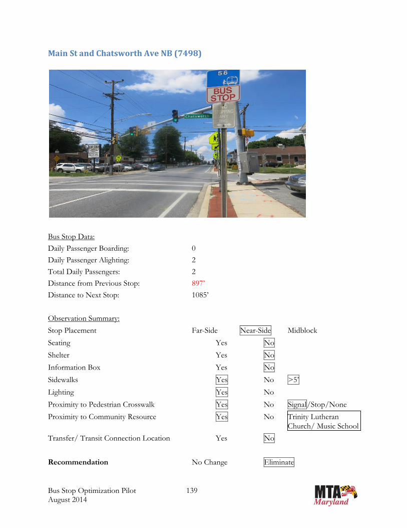
Main St and Chatsworth Ave NB (7498)
Bus Stop Data:
Daily Passenger Boarding: 0
Daily Passenger Alighting: 2
Total Daily Passengers: 2
Distance from Previous Stop: 897’
Distance to Next Stop: 1085’
Observation Summary:
Stop Placement Far-Side Near-Side Midblock
Seating Yes No
Shelter Yes No
Information Box Yes No
Sidewalks Yes No >5’
Lighting Yes No
Proximity to Pedestrian Crosswalk Yes No Signal/Stop/None
Proximity to Community Resource Yes No Trinity Lutheran
Church/ Music School
Transfer/ Transit Connection Location Yes No
Recommendation No Change Eliminate
")
")
")
7498
1132
3
1132
1
30
140
Main StHanover Pike
Westmins
ter Pi
ke
Reisterstown Rd
Chatsworth Ave E
Cockeys Mill Rd
Bond Ave
Wolf AveVillage Center Rd
Chatsworth Ave W
Pidco Rd
Harvestview RdCarolstowne Rd
Source: Esri, DigitalGlobe, GeoEye, i-cubed, Earthstar Geographics, CNES/Airbus DS, USDA, USGS,AEX, Getmapping, Aerogrid, IGN, IGP, swisstopo, and the GIS User Community
³
1 inch = 348 feet
0 310 620 930 1,240155Feet
Stop Name: Main St & Chatsworth Ave NbStop ID: 7498 Daily On: 0
Daily Off: 2Daily Total: 2
To Next Stop: 1085 ft.To Previous Stop: 897 ft.Between Stops If Eliminated: 1982 ft.
Line Name: Glyndon - Owings Mills MallLine Number: 56 NORTHBOUND
Bus RouteÆa Bus Stop
Land Use Class: SUBURBAN
LegendMeasuresRidership

Bus Stop Optimization Pilot 141 August 2014
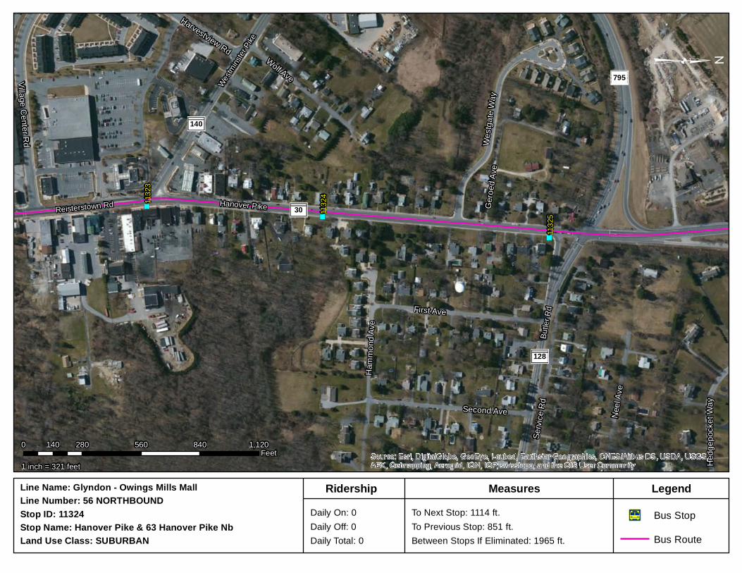
Hanover Pike and 63 Hanover Pike NB (11324)
Bus Stop Data:
Daily Passenger Boarding: 0
Daily Passenger Alighting: 0
Total Daily Passengers: 0
Distance from Previous Stop: 851’
Distance to Next Stop: 1114’
Observation Summary:
Stop Placement Far-Side Near-Side Midblock
Seating Yes No
Shelter Yes No
Information Box Yes No
Sidewalks Yes No >5’
Lighting Yes No
Proximity to Pedestrian Crosswalk Yes No Signal/Stop/None
Proximity to Community Resource Yes No
Transfer/ Transit Connection Location Yes No
Recommendation No Change Eliminate
Note: Consider re-naming to Hanover Rd & Hanover Rd, as opposed to Pike
")
")
") 1132
51132
41132
3
30
140
795
128
Hanover Pike
Butle
r Rd
Westmins
ter Pi
ke
Reisterstown Rd
First Ave
Servi
ce R
d
Neel
Ave
Wolf Ave
Second Ave
Westg
ate W
ay
Hamm
ond A
ve
Village Center Rd
Geroe
d Ave
Hedg
epoc
ket W
ay
Harvestview Rd
Source: Esri, DigitalGlobe, GeoEye, i-cubed, Earthstar Geographics, CNES/Airbus DS, USDA, USGS,AEX, Getmapping, Aerogrid, IGN, IGP, swisstopo, and the GIS User Community
³
1 inch = 321 feet
0 280 560 840 1,120140Feet
Stop Name: Hanover Pike & 63 Hanover Pike NbStop ID: 11324 Daily On: 0
Daily Off: 0Daily Total: 0
To Next Stop: 1114 ft.To Previous Stop: 851 ft.Between Stops If Eliminated: 1965 ft.
Line Name: Glyndon - Owings Mills MallLine Number: 56 NORTHBOUND
Bus RouteÆa Bus Stop
Land Use Class: SUBURBAN
LegendMeasuresRidership

Bus Stop Optimization Pilot 143 August 2014
Route No. 56 SB – Summary Table
Route No. 56 SB – Recommended Stops for Elimination
Stop ID
Stop Name - Route 56 SB
Passengers Distances (feet)
Land Use Daily On
Daily Off
Daily Total
% of Route
To Previous
Stop
To Next Stop
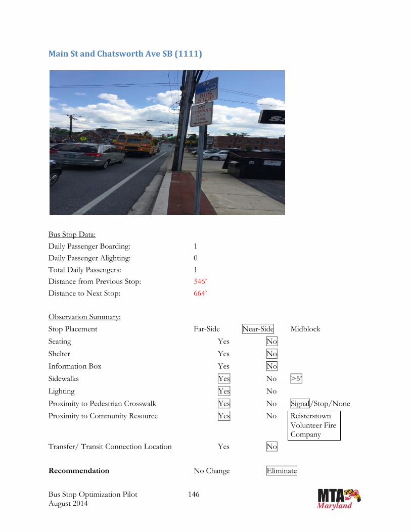
1111 MAIN ST & CHATSWORTH AVE sb 1 0 1 0.1% 546 664 SUBURBAN
11238 MAIN ST & WOODLEY AVE sb 0 0 0 0.0% 1038 810 SUBURBAN
11239 MAIN ST & BERRYMANS LN sb 0 0 0 0.0% 187 1060 SUBURBAN
11244 REISTERSTOWN RD & AUSTIN RD OP sb 0 0 0 0.0% 976 972 SUBURBAN
7449 REISTERSTOWN RD & NICODEMUS RD mid sb 2 0 2 0.1% 976 1317 SUBURBAN
11249 REISTERSTOWN RD & GWYNNBROOK AVE OP sb 0 1 1 0.1% 362 1673 SUBURBAN
11251 REISTERSTOWN RD & PLEASANT HILL RD sb 0 0 0 0.0% 492 726 SUBURBAN
11253 REISTERSTOWN RD & OLD TOLLGATE RD sb 0 0 0 0.0% 519 658 SUBURBAN
Æa
Æa
Æa
Æa
Æa
Æa
Æa
Æa ÆaÆa Æa Æa Æa Æa Æa Æa Æa Æa Æa Æa Æa Æa Æa Æa Æa Æa Æa Æa Æa ÆaÆa
Æa
Æa
ÆaÆa
Æa
Æa
1143
7457
7455
7982113274
497446
1115
1111
1107
1231
5
1125
9
1125
8
1125
6
1125
4
1125
312
318
1125
2
1125
112
316
1124
912
314
1124
8
1124
7
1124
5
1124
4
1124
3
1124
2
1124
1
1124
0
1123
8
1123
71123
6
1132
7
1132
6
§̈¦795
140
79530
940
128
940
Reisterstown Rd
Butle
r RdHanover Pike
Main St Westminster Pike
²Line Name: Glyndon - Owings Mills MallLine Number: 56Direction: South Bus Route
Æa Bus StopLegend
1 inch = 1,989 feet
0 2,300 4,600 6,900 9,2001,150 Feet
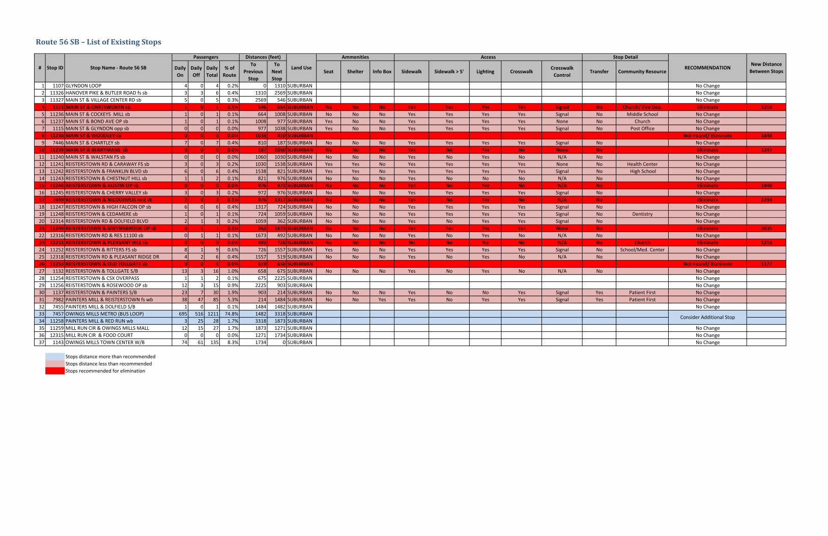
Route56SB–ListofExistingStops
Daily
On
Daily
Off
Daily
Total
% of
Route
To
Previous
Stop
To
Next
Stop
Seat Shelter Info Box Sidewalk Sidewalk > 5' Lighting CrosswalkCrosswalk
ControlTransfer Community Resource
1 1107 GLYNDON LOOP 4 0 4 0.2% 0 1310 SUBURBAN No Change2 11326 HANOVER PIKE & BUTLER ROAD fs sb 3 3 6 0.4% 1310 2569 SUBURBAN No Change3 11327 MAIN ST & VILLAGE CENTER RD sb 5 0 5 0.3% 2569 546 SUBURBAN No Change4 1111 MAIN ST & CHATSWORTH sb 1 0 1 0.1% 546 664 SUBURBAN No No No Yes Yes Yes Yes Signal No Church/ Fire Dep. Eliminate 1210
5 11236 MAIN ST & COCKEYS MILL sb 1 0 1 0.1% 664 1008 SUBURBAN No No No Yes Yes Yes Yes Signal No Middle School No Change6 11237 MAIN ST & BOND AVE OP sb 1 0 1 0.1% 1008 977 SUBURBAN Yes No No Yes Yes Yes Yes None No Church No Change7 1115 MAIN ST & GLYNDON opp sb 0 0 0 0.0% 977 1038 SUBURBAN Yes No No Yes Yes Yes Yes Signal No Post Office No Change8 11238 MAIN ST & WOODLEY sb 0 0 0 0.0% 1038 810 SUBURBAN Not Found/ Eliminate 1848
9 7446 MAIN ST & CHARTLEY sb 7 0 7 0.4% 810 187 SUBURBAN No No No Yes Yes Yes Yes Signal No No Change10 11239 MAIN ST & BERRYMANS sb 0 0 0 0.0% 187 1060 SUBURBAN No No No Yes No Yes No None No Eliminate 1247
11 11240 MAIN ST & WALSTAN FS sb 0 0 0 0.0% 1060 1030 SUBURBAN No No No Yes No Yes No N/A No No Change12 11241 REISTERSTOWN RD & CARAWAY FS sb 3 0 3 0.2% 1030 1538 SUBURBAN Yes Yes No Yes Yes Yes Yes None No Health Center No Change13 11242 REISTERSTOWN & FRANKLIN BLVD sb 6 0 6 0.4% 1538 821 SUBURBAN Yes Yes No Yes Yes Yes Yes Signal No High School No Change14 11243 REISTERSTOWN & CHESTNUT HILL sb 1 1 2 0.1% 821 976 SUBURBAN No No No Yes No No No N/A No No Change15 11244 REISTERSTOWN & AUSTIN OP sb 0 0 0 0.0% 976 972 SUBURBAN No No No Yes No Yes No N/A No Eliminate 1948
16 11245 REISTERSTOWN & CHERRY VALLEY sb 3 0 3 0.2% 972 976 SUBURBAN No No No Yes Yes Yes Yes Signal No No Change17 7449 REISTERSTOWN & NICODEMUS mid sb 2 0 2 0.1% 976 1317 SUBURBAN No No No Yes No Yes No N/A No Eliminate 2293
18 11247 REISTERSTOWN & HIGH FALCON OP sb 6 0 6 0.4% 1317 724 SUBURBAN No No No Yes Yes Yes Yes Signal No No Change19 11248 REISTERSTOWN & CEDAMERE sb 1 0 1 0.1% 724 1059 SUBURBAN No No No Yes Yes Yes Yes Signal No Dentistry No Change20 12314 REISTERSTOWN RD & DOLFIELD BLVD 2 1 3 0.2% 1059 362 SUBURBAN No No No Yes No Yes Yes Signal No No Change21 11249 REISTERSTOWN & GWYNNBROOK OP sb 0 1 1 0.1% 362 1673 SUBURBAN No No No Yes Yes Yes Yes None No Eliminate 2035
22 12316 REISTERSTOWN RD & RES 11100 sb 0 1 1 0.1% 1673 492 SUBURBAN No No No Yes No Yes No N/A No No Change23 11251 REISTERSTOWN & PLEASANT HILL sb 0 0 0 0.0% 492 726 SUBURBAN No No No No No No No N/A No Church Eliminate 1218
24 11252 REISTERSTOWN & RITTERS FS sb 8 1 9 0.6% 726 1557 SUBURBAN Yes No No Yes Yes Yes Yes Signal No School/Med. Center No Change25 12318 REISTERSTOWN RD & PLEASANT RIDGE DR 4 2 6 0.4% 1557 519 SUBURBAN No No No Yes No Yes No N/A No No Change26 11253 REISTERSTOWN & OLD TOLLGATE sb 0 0 0 0.0% 519 658 SUBURBAN Not Found/ Eliminate 1177
27 1132 REISTERSTOWN & TOLLGATE S/B 13 3 16 1.0% 658 675 SUBURBAN No No No Yes No Yes No N/A No No Change28 11254 REISTERSTOWN & CSX OVERPASS 1 1 2 0.1% 675 2225 SUBURBAN No Change29 11256 REISTERSTOWN & ROSEWOOD OP sb 12 3 15 0.9% 2225 903 SUBURBAN No Change30 1137 REISTERSTOWN & PAINTERS S/B 23 7 30 1.9% 903 214 SUBURBAN No No No Yes No No Yes Signal Yes Patient First No Change31 7982 PAINTERS MILL & REISTERSTOWN fs wb 38 47 85 5.3% 214 1484 SUBURBAN No No Yes Yes No Yes Yes Signal Yes Patient First No Change32 7455 PAINTERS MILL & DOLFIELD S/B 1 0 1 0.1% 1484 1482 SUBURBAN No Change33 7457 OWINGS MILLS METRO (BUS LOOP) 695 516 1211 74.8% 1482 3318 SUBURBAN34 11258 PAINTERS MILL & RED RUN wb 3 25 28 1.7% 3318 1873 SUBURBAN35 11259 MILL RUN CIR & OWINGS MILLS MALL 12 15 27 1.7% 1873 1271 SUBURBAN No Change36 12315 MILL RUN CIR & FOOD COURT 0 0 0 0.0% 1271 1734 SUBURBAN No Change37 1143 OWINGS MILLS TOWN CENTER W/B 74 61 135 8.3% 1734 0 SUBURBAN No Change
Stops distance more than recommendedStops distance less than recommendedStops recommended for elimination
Ammenities
Land Use# Stop ID Stop Name ‐ Route 56 SB
Passengers Distances (feet)
Consider Additional Stop
Access Stop Detail
RECOMMENDATIONNew Distance
Between Stops
Bus Stop Optimization Pilot 146 August 2014
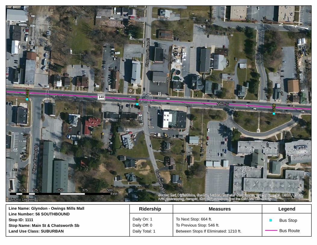
Main St and Chatsworth Ave SB (1111)
Bus Stop Data:
Daily Passenger Boarding: 1
Daily Passenger Alighting: 0
Total Daily Passengers: 1
Distance from Previous Stop: 546’
Distance to Next Stop: 664’
Observation Summary:
Stop Placement Far-Side Near-Side Midblock
Seating Yes No
Shelter Yes No
Information Box Yes No
Sidewalks Yes No >5’
Lighting Yes No
Proximity to Pedestrian Crosswalk Yes No Signal/Stop/None
Proximity to Community Resource Yes No Reisterstown
Volunteer Fire Company
Transfer/ Transit Connection Location Yes No
Recommendation No Change Eliminate
")
")
")
1111
1123
6
1132
7
140Main St
Villag
e Cen
ter R
d
Chatsworth Ave WCh
atswo
rth Av
e E
Source: Esri, DigitalGlobe, GeoEye, i-cubed, Earthstar Geographics, CNES/Airbus DS, USDA, USGS,AEX, Getmapping, Aerogrid, IGN, IGP, swisstopo, and the GIS User Community
³
1 inch = 144 feet
0 125 250 375 50062.5Feet
Stop Name: Main St & Chatsworth SbStop ID: 1111 Daily On: 1
Daily Off: 0Daily Total: 1
To Next Stop: 664 ft.To Previous Stop: 546 ft.Between Stops If Eliminated: 1210 ft.
Line Name: Glyndon - Owings Mills MallLine Number: 56 SOUTHBOUND
Land Use Class: SUBURBAN
LegendMeasuresRidership
Bus Route
") Bus Stop
Bus Stop Optimization Pilot 148 August 2014
Main St and Woodley Ave SB (11238) NOT FOUND
Bus Stop Data:
Daily Passenger Boarding: 0
Daily Passenger Alighting: 0
Total Daily Passengers: 0
Distance from Previous Stop: 1038’
Distance to Next Stop: 810’
Observation Summary:
Stop Placement Far-Side Near-Side Midblock
Seating Yes No
Shelter Yes No
Information Box Yes No
Sidewalks Yes No <5’
Lighting Yes No
Proximity to Pedestrian Crosswalk Yes No Signal/Stop/None
Proximity to Community Resource Yes No
Transfer/ Transit Connection Location Yes No
Recommendation Not Found - Eliminate

")
")
")74
46
1115
1123
8
140
Main St
Glynd
on Dr
Chartley Dr
Owings Ave
Dean Ave
Stocks
dale A
ve
Shirle
y Ave
Piper Rd
Wood
ley Av
e
Wood
ley Av
e
Source: Esri, DigitalGlobe, GeoEye, i-cubed, Earthstar Geographics, CNES/Airbus DS, USDA, USGS,AEX, Getmapping, Aerogrid, IGN, IGP, swisstopo, and the GIS User Community
³
1 inch = 198 feet
0 175 350 525 70087.5Feet
Stop Name: Main St & Woodley SbStop ID: 11238 Daily On: 0
Daily Off: 0Daily Total: 0
To Next Stop: 810 ft.To Previous Stop: 1038 ft.Between Stops If Eliminated: 1848 ft.
Line Name: Glyndon - Owings Mills MallLine Number: 56 SOUTHBOUND
Land Use Class: SUBURBAN
LegendMeasuresRidership
Bus Route
") Bus Stop

Bus Stop Optimization Pilot 150 August 2014
Main St and Berrymans Ln SB (11239)
Bus Stop Data:
Daily Passenger Boarding: 0
Daily Passenger Alighting: 0
Total Daily Passengers: 0
Distance from Previous Stop: 187’
Distance to Next Stop: 1060’
Observation Summary:
Stop Placement Far-Side Near-Side Midblock
Seating Yes No
Shelter Yes No
Information Box Yes No
Sidewalks Yes No <5’
Lighting Yes No
Proximity to Pedestrian Crosswalk Yes No Signal/Stop/None
Proximity to Community Resource Yes No
Transfer/ Transit Connection Location Yes No
Recommendation No Change Eliminate

")")
")
7446
1124
01123
9
140Main St
Beverly Rd
Chart
ley D
r Walgr
ove R
d
Walst
an Av
eBerry
mans
La
Source: Esri, DigitalGlobe, GeoEye, i-cubed, Earthstar Geographics, CNES/Airbus DS, USDA, USGS,AEX, Getmapping, Aerogrid, IGN, IGP, swisstopo, and the GIS User Community
³
1 inch = 146 feet
0 130 260 390 52065Feet
Stop Name: Main St & Berrymans Sb Stop ID: 11239 Daily On: 0
Daily Off: 0Daily Total: 0
To Next Stop: 1060 ft.To Previous Stop: 187 ft.Between Stops If Eliminated: 1247 ft.
Line Name: Glyndon - Owings Mills MallLine Number: 56 SOUTHBOUND
Land Use Class: SUBURBAN
LegendMeasuresRidership
Bus Route
") Bus Stop
Bus Stop Optimization Pilot 152 August 2014
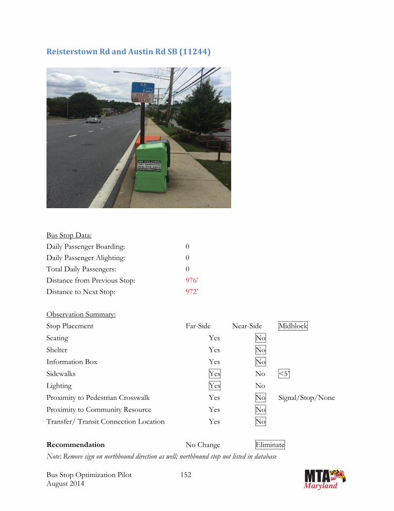
Reisterstown Rd and Austin Rd SB (11244)
Bus Stop Data:
Daily Passenger Boarding: 0
Daily Passenger Alighting: 0
Total Daily Passengers: 0
Distance from Previous Stop: 976’
Distance to Next Stop: 972’
Observation Summary:
Stop Placement Far-Side Near-Side Midblock
Seating Yes No
Shelter Yes No
Information Box Yes No
Sidewalks Yes No <5’
Lighting Yes No
Proximity to Pedestrian Crosswalk Yes No Signal/Stop/None
Proximity to Community Resource Yes No
Transfer/ Transit Connection Location Yes No
Recommendation No Change Eliminate
Note: Remove sign on northbound direction as well; northbound stop not listed in database

")
") ")11
245
1124
4
1124
3 140Reisterstown Rd
Austin Rd
Terrytown Dr
Roaches La
Ches
tnut H
ill La
Hamm
ershir
e Rd
Virginia Ave
Cherr
y Vall
ey R
d
Chestnut Hill La W
Maren Ct Source: Esri, DigitalGlobe, GeoEye, i-cubed, Earthstar Geographics, CNES/Airbus DS, USDA, USGS,AEX, Getmapping, Aerogrid, IGN, IGP, swisstopo, and the GIS User Community
³
1 inch = 223 feet
0 190 380 570 76095Feet
Stop Name: Reisterstown & Austin Op SbStop ID: 11244 Daily On: 0
Daily Off: 0Daily Total: 0
To Next Stop: 972 ft.To Previous Stop: 976 ft.Between Stops If Eliminated: 1948 ft.
Line Name: Glyndon - Owings Mills MallLine Number: 56 SOUTHBOUND
Land Use Class: SUBURBAN
LegendMeasuresRidership
Bus Route
") Bus Stop

Bus Stop Optimization Pilot 154 August 2014
Reisterstown Rd and Nicodemus Rd SB (7449)
Bus Stop Data:
Daily Passenger Boarding: 2
Daily Passenger Alighting: 0
Total Daily Passengers: 2
Distance from Previous Stop: 976’
Distance to Next Stop: 1317’
Observation Summary:
Stop Placement Far-Side Near-Side Midblock
Seating Yes No
Shelter Yes No
Information Box Yes No
Sidewalks Yes No <5’
Lighting Yes No
Proximity to Pedestrian Crosswalk Yes No Signal/Stop/None
Proximity to Community Resource Yes No
Transfer/ Transit Connection Location Yes No
Recommendation No Change Eliminate

")
")
")
7449 1124
7
1124
5 140Reisterstown Rd
Delight RdNicode
mus Rd
Timber
Grove R
d
Hamm
ershir
e Rd
Cherr
y Vall
ey R
d
Sunset Rd
High Falcon Rd
Fennington Cir
Shetl
and C
ir
Terrytown Dr
Maybin Cir
Shropshire Ct
Source: Esri, DigitalGlobe, GeoEye, i-cubed, Earthstar Geographics, CNES/Airbus DS, USDA, USGS,AEX, Getmapping, Aerogrid, IGN, IGP, swisstopo, and the GIS User Community
³
1 inch = 251 feet
0 220 440 660 880110Feet
Stop Name: Reisterstown & Nicodemus Mid SbStop ID: 7449 Daily On: 2
Daily Off: 0Daily Total: 2
To Next Stop: 1317 ft.To Previous Stop: 976 ft.Between Stops If Eliminated: 2293 ft.
Line Name: Glyndon - Owings Mills MallLine Number: 56 SOUTHBOUND
Land Use Class: SUBURBAN
LegendMeasuresRidership
Bus Route
") Bus Stop
Bus Stop Optimization Pilot 156 August 2014
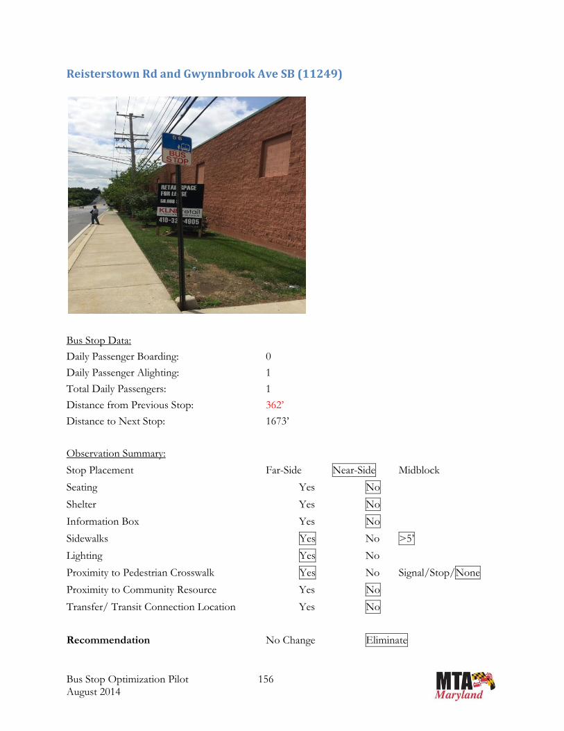
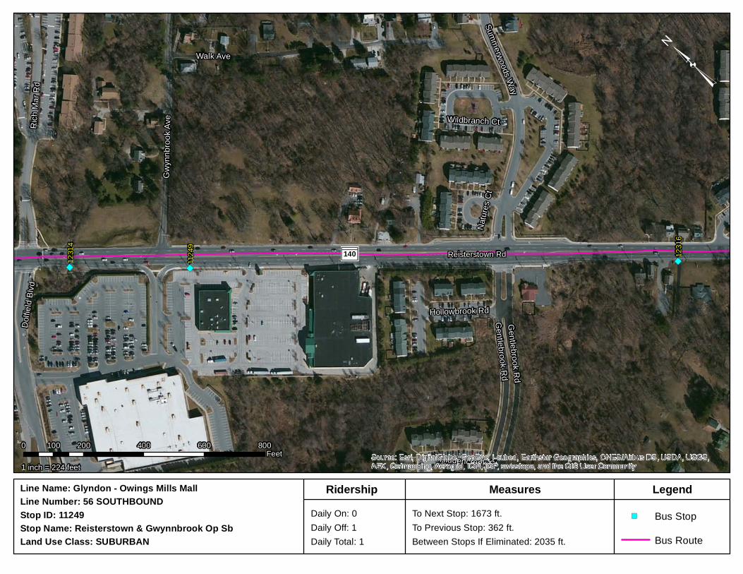
Reisterstown Rd and Gwynnbrook Ave SB (11249)
Bus Stop Data:
Daily Passenger Boarding: 0
Daily Passenger Alighting: 1
Total Daily Passengers: 1
Distance from Previous Stop: 362’
Distance to Next Stop: 1673’
Observation Summary:
Stop Placement Far-Side Near-Side Midblock
Seating Yes No
Shelter Yes No
Information Box Yes No
Sidewalks Yes No >5’
Lighting Yes No
Proximity to Pedestrian Crosswalk Yes No Signal/Stop/None
Proximity to Community Resource Yes No
Transfer/ Transit Connection Location Yes No
Recommendation No Change Eliminate
") ")
")12
316
1124
9
1231
4
140 Reisterstown Rd
Walk Ave
Rich M
ar Rd
Gwyn
nbroo
k Ave
Gentlebrook Rd
Summerwoods Way
Dolfie
ld Blv
d
Hollowbrook Rd
Hiddencreek Ct
Wildbranch Ct
Natur
es C
t
Gentlebrook Rd
Source: Esri, DigitalGlobe, GeoEye, i-cubed, Earthstar Geographics, CNES/Airbus DS, USDA, USGS,AEX, Getmapping, Aerogrid, IGN, IGP, swisstopo, and the GIS User Community
³
1 inch = 224 feet
0 200 400 600 800100Feet
Stop Name: Reisterstown & Gwynnbrook Op SbStop ID: 11249 Daily On: 0
Daily Off: 1Daily Total: 1
To Next Stop: 1673 ft.To Previous Stop: 362 ft.Between Stops If Eliminated: 2035 ft.
Line Name: Glyndon - Owings Mills MallLine Number: 56 SOUTHBOUND
Land Use Class: SUBURBAN
LegendMeasuresRidership
Bus Route
") Bus Stop

Bus Stop Optimization Pilot 158 August 2014
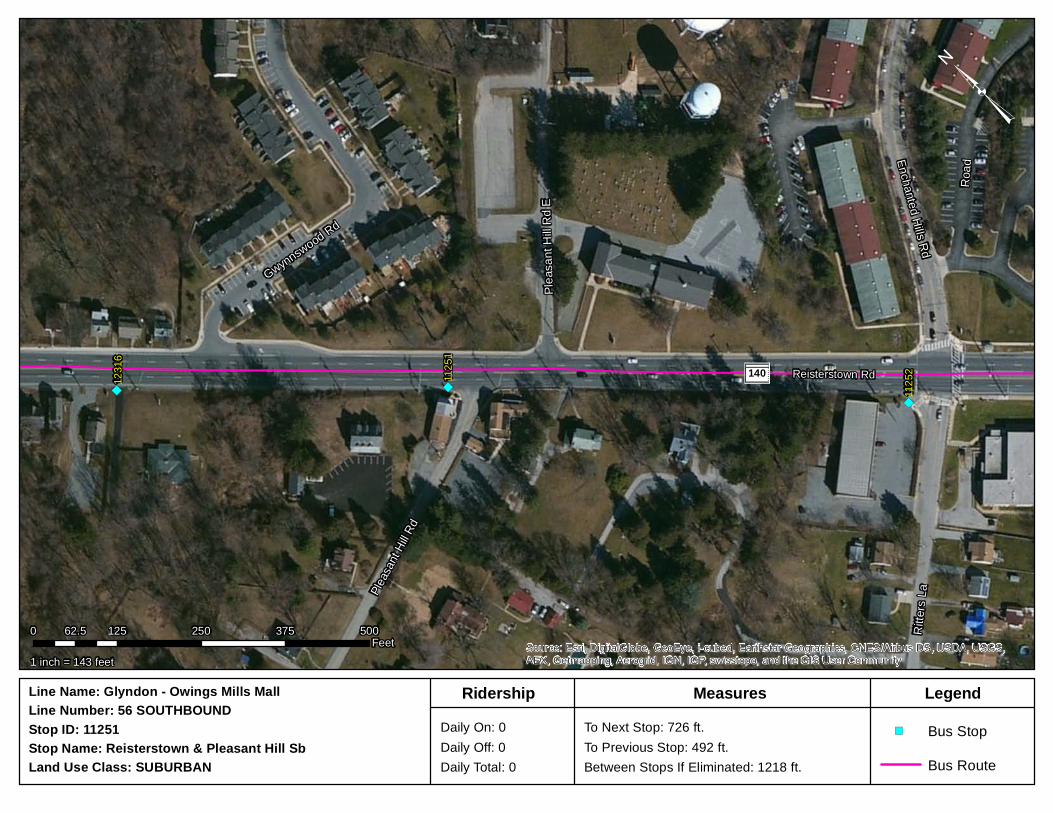
Reisterstown Rd and Pleasant Hill Rd SB (11251)
Bus Stop Data:
Daily Passenger Boarding: 0
Daily Passenger Alighting: 0
Total Daily Passengers: 0
Distance from Previous Stop: 492’
Distance to Next Stop: 726’
Observation Summary:
Stop Placement Far-Side Near-Side Midblock
Seating Yes No
Shelter Yes No
Information Box Yes No
Sidewalks Yes No <5’
Lighting Yes No
Proximity to Pedestrian Crosswalk Yes No Signal/Stop/None
Proximity to Community Resource Yes No Pleasant Hill United
Methodist Church
Transfer/ Transit Connection Location Yes No
Recommendation No Change Eliminate
") ")
")11
2521125
1
1231
6
140 Reisterstown Rd
Road
Ritter
s La
Gwynnswood Rd
Pleasa
nt Hil
l Rd
Pleas
ant H
ill Rd E
Enchanted Hills Rd
Source: Esri, DigitalGlobe, GeoEye, i-cubed, Earthstar Geographics, CNES/Airbus DS, USDA, USGS,AEX, Getmapping, Aerogrid, IGN, IGP, swisstopo, and the GIS User Community
³
1 inch = 143 feet
0 125 250 375 50062.5Feet
Stop Name: Reisterstown & Pleasant Hill Sb Stop ID: 11251 Daily On: 0
Daily Off: 0Daily Total: 0
To Next Stop: 726 ft.To Previous Stop: 492 ft.Between Stops If Eliminated: 1218 ft.
Line Name: Glyndon - Owings Mills MallLine Number: 56 SOUTHBOUND
Land Use Class: SUBURBAN
LegendMeasuresRidership
Bus Route
") Bus Stop

Bus Stop Optimization Pilot 160 August 2014
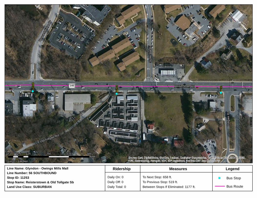
Reisterstown Rd and Old Tollgate Rd SB (11253) NOT FOUND
Bus Stop Data:
Daily Passenger Boarding: 0
Daily Passenger Alighting: 0
Total Daily Passengers: 0
Distance from Previous Stop: 519’
Distance to Next Stop: 658’
Observation Summary:
Stop Placement Far-Side Near-Side Midblock
Seating Yes No
Shelter Yes No
Information Box Yes No
Sidewalks Yes No <5’
Lighting Yes No
Proximity to Pedestrian Crosswalk Yes No Signal/Stop/None
Proximity to Community Resource Yes No
Transfer/ Transit Connection Location Yes No
Recommendation Not Found - Eliminate
")
") ")11
32
1125
3
1231
8
140 Reisterstown Rd
Old Tollgate Rd
Tollg
ate R
d
Straw
Hat
Rd
Pleasa
nt Rid
ge Dr
Source: Esri, DigitalGlobe, GeoEye, i-cubed, Earthstar Geographics, CNES/Airbus DS, USDA, USGS,AEX, Getmapping, Aerogrid, IGN, IGP, swisstopo, and the GIS User Community
³
1 inch = 144 feet
0 125 250 375 50062.5Feet
Stop Name: Reisterstown & Old Tollgate Sb Stop ID: 11253 Daily On: 0
Daily Off: 0Daily Total: 0
To Next Stop: 658 ft.To Previous Stop: 519 ft.Between Stops If Eliminated: 1177 ft.
Line Name: Glyndon - Owings Mills MallLine Number: 56 SOUTHBOUND
Land Use Class: SUBURBAN
LegendMeasuresRidership
Bus Route
") Bus Stop