rock creek gold creek risk analysis and prescriptions final · pdf fileadams lake anglemont...
TRANSCRIPT

2006 FIA
Gold Creek / Rock Creek Inspections Monitoring, Road Deactivation
and Environmental Road Maintenance Planning Risk Analysis
Prepared for:
Prepared by:
Forsite Consultants Ltd. #330 42nd St SW Salmon Arm, BC
V1E 4R1
Tel: (250) 832 3366 Fax: (250) 832 3811
October 31st, 2006

Adams Lake Lumber FCL File: 1-66 Inspections Monitoring, Road Deactivation and Environmental Road Maintenance Planning Risk Analysis October 2006
S:\1\66\Current\Documents\Reports\Rock Creek Gold Creek Risk Analysis and Prescriptions FINAL.doc
ii
Table of Contents
TABLE OF CONTENTS ..................................................................................................................................................II
1.0 INTRODUCTION .................................................................................................................................................4
1.1 SCOPE OF ASSESSMENT ........................................................................................................................................4 1.2 CONVENTIONS FOLLOWED ...................................................................................................................................4
2.0 OFFICE AND FIELD REVIEW..........................................................................................................................5
3.0 TERRAIN CHARACTERISTICS AND GEOMORPHOLOGICAL PROCESSES.......................................7
4.0 RISK ANALYSIS PROCEDURE ........................................................................................................................7
5.0 OBSERVATIONS ANALYSIS AND RECOMMENDATIONS .......................................................................8
5.1 GOLD CREEK – SITE A (REACH 0139) ..................................................................................................................8 5.2 GOLD CREEK – SITE B (REACH 2902) ................................................................................................................11 5.3 GOLD CREEK – REACH 0106 ..............................................................................................................................14 5.4 GOLD CREEK – REACH 0134 / 7902 ...................................................................................................................15 5.5 GOLD CREEK – REACH 1901 ..............................................................................................................................18 5.6 GOLD CREEK – REACH 3801 ..............................................................................................................................19 5.7 GOLD CREEK – REACH 4700 / 4601 ...................................................................................................................21 5.8 GOLD CREEK – REACH 6402 ..............................................................................................................................23 5.9 GOLD CREEK – REACH 6207 / 6208 ...................................................................................................................26 5.10 GOLD CREEK – REACH 7001 ..............................................................................................................................28 5.11 GOLD CREEK – REACH 7203 ..............................................................................................................................30 5.12 GOLD CREEK – REACH 7205 ..............................................................................................................................31 5.13 GOLD CREEK – REACH 7604 ..............................................................................................................................32 5.14 GOLD CREEK – SITE 1 ........................................................................................................................................34 5.15 GOLD CREEK – SITE 7 ........................................................................................................................................35 5.16 GOLD CREEK – SITE 8 ........................................................................................................................................37 5.17 GOLD CREEK – SITE 9 / 10..................................................................................................................................39 5.18 ROCK CREEK – SITE 1 ........................................................................................................................................41 5.19 ROCK CREEK – SITE 2 ........................................................................................................................................43 5.20 ROCK CREEK – SITE 3 ........................................................................................................................................45 5.21 ROCK CREEK – SITE 4 ........................................................................................................................................47 5.22 ROCK CREEK – SITE 5 ........................................................................................................................................48 5.23 ROCK CREEK – SITE 6 ........................................................................................................................................50 5.24 ROCK CREEK – SITE 7 ........................................................................................................................................52 5.25 ROCK CREEK – SITE 8 ........................................................................................................................................53 5.26 ROCK CREEK – SITE 9 ........................................................................................................................................54 5.27 ROCK CREEK – SITE 10 ......................................................................................................................................56 5.28 ROCK CREEK – SITE 11 ......................................................................................................................................58 5.29 ROCK CREEK – SITE 12 ......................................................................................................................................63 5.30 ROCK CREEK – SITE 13 ......................................................................................................................................65 5.X ROCK CREEK – SITE 14 ......................................................................................................................................66 5.31 MOSQUITO CREEK (SITE 1) ................................................................................................................................67 5.32 HONEYMOON BAY (SITE 2) ................................................................................................................................71 5.33 MOMICH LAKE SITE 3 ........................................................................................................................................75 5.34 MOMICH LAKE SITE 5 ........................................................................................................................................77
6.0 CLOSURE............................................................................................................................................................78

Adams Lake Lumber FCL File: 1-66 Inspections Monitoring, Road Deactivation and Environmental Road Maintenance Planning Risk Analysis October 2006
S:\1\66\Current\Documents\Reports\Rock Creek Gold Creek Risk Analysis and Prescriptions FINAL.doc
iii
LIST OF FIGURES
Figure 1 Location Key Map……………………………………………………………..6
Figure 2 Gold Creek Sites……………...…………………………………….……….…attached
Figure 3 Rock Creek Sites..………………………………………….……….……….…attached
Figure 4 Site 0139 detail……………………………………………..…………………..10
Figure 5 Site R-9, Branch D Road detail………………………………………….……..55
Figure 6 Site R-11, “Branch C” Road detail ……………………..……………….……..62
Figure 7 Mosquito Creek Site 1 detail…………………………………………………...70

Adams Lake Lumber FCL File: 1-66 Inspections Monitoring, Road Deactivation and Environmental Road Maintenance Planning Risk Analysis October 2006
Page 4
S:\1\66\Current\Documents\Reports\Rock Creek Gold Creek Risk Analysis and Prescriptions FINAL.doc
1.0 Introduction
Forsite Consultants Ltd. (Forsite) was retained to carry out post work inspections, monitoring and prescriptions
for sites in the Rock Creek, Gold Creek, Mosquito Creek, Marjory Creek and Momich Watersheds. (see figure
1 for a key map).These sites have had previous work and/or inspections completed. The objective of this
report is to address remaining concerns and to establish closure on these sites.
1.1 Scope of Assessment
The purpose of this report is:
• To describe conditions at specific assessment sites and where such conditions may have a specific
impact.
• To provide a Risk Analysis of the potential environmental impacts of the assessment sites
• To recommend site-specific actions to reduce the likelihood of further environmental impacts.
1.2 Conventions Followed
• Soil classifications and landform descriptions use terminology defined in the publication Terrain
Classification System for British Columbia B.C. Ministry of Environment 1997.
• Slope gradient classification follows the convention defined in the publication Terrain Classification
System for British Columbia B.C. Ministry of Environment 1997.
Gentle 5-27%
Moderate 28-49%
Moderately Steep 50-70%
Steep > 70%

Adams Lake Lumber FCL File: 1-66 Inspections Monitoring, Road Deactivation and Environmental Road Maintenance Planning Risk Analysis October 2006
Page 5
S:\1\66\Current\Documents\Reports\Rock Creek Gold Creek Risk Analysis and Prescriptions FINAL.doc
2.0 Office and Field Review
Prior to and following the field assessment the following materials were reviewed:
• Stereo air photo coverage of the study area (~1:20,000 scale)
• 1:20,000 digital design file maps
• Geologic Survey of Canada Bedrock Geology Mapping located on Ministry of Energy and Mines
MapPlace webpage http://webmap.em.gov.bc.ca/mapplace/minpot/bcgs.cfm
Gold Creek
• Level 2 Fish Habitat Assessment (Silvatech 1995)
• Level 2 Road Condition Assessment 9silvatech 1996)
• Detailed Proposal – Zone 1 and 2 Works Phase (Silvatech 1996)
• Level 2 Stream Channel Assessment (Silvatech 1998)
• Bioengineering as-builts (Silvatech 1998)
• Watershed Restoration Plan (Silvatech 2001)
• Road Assessment 9Silvatech 2004)
Fieldwork was completed by Peter Weisinger M.Sc. GIT of Forsite on August 14, 15th and 18th-19
th 2006. See
Figure 2 for a map of the study area and location of the assessment sites.
A helicopter over-flight of the Gold Creek sites was completed on August 11th 2006. Attending were Peter
Weisinger M.Sc. GIT and Rod Williams P.Geo of Forsite. The helicopter overflight focussed primarily on
previously identified sites, but observations of general watershed condition and sediment sources and other
potential problem areas were noted.
Rock Creek
• Environmental Maintenance Project Plan (Summit 2003)
• Road Assessment (2004)
• Environmental Maintenance Projects (Mosquito, Honeymoon, Marjory)
Fieldwork was completed by Peter Weisinger M.Sc. GIT of Forsite on August 1-4th, See Figure 3 for a map of
the study area and location of the assessment sites. Additional field review of the Rock Creek site R11 was
conducted on October 20, 2006.

Adams Lake Lumber FCL File: 1-66 Inspections Monitoring, Road Deactivation and Environmental Road Maintenance Planning Risk Analysis October 2006
Page 6
S:\1\66\Current\Documents\Reports\Rock Creek Gold Creek Risk Analysis and Prescriptions FINAL.doc
Adams Lake
Anglemont
Annis
Balmoral
Birch Island
Blind Bay
Blucher Hall
Celista Eagle Bay
Lee Creek
Magna Bay
Notch Hill
Scotch Creek
Seymour Arm
Sicamous
Solsqua
Sorrento Squilax
St. Ives
Sun Peaks
Vavenby
Figure 1 – Key Map
Gold Creek Sites (Figure 2)
Rock Creek Sites (Figure 3)
Rock Creek
Honeymoon Bay Momich Lake
Mosquito Creek
Gold Creek

Adams Lake Lumber FCL File: 1-66 Inspections Monitoring, Road Deactivation and Environmental Road Maintenance Planning Risk Analysis October 2006
Page 7
S:\1\66\Current\Documents\Reports\Rock Creek Gold Creek Risk Analysis and Prescriptions FINAL.doc
3.0 Terrain Characteristics and Geomorphological Processes
3.1 Rock Creek / North Adams Lake Sites
The sites in the Rock Creek area are generally located either in the valley bottoms, or on mid slopes. Soils
encountered were generally either sandy tills or sandy glaciofluvial and fluvial materials. These soils wee
found to have low cohesion and were easily eroded. The upper portion of Rock Creek is on a wet rolling
plateau, with the creek becoming incised in its lower reaches. Instability in this area was generally limited to
sediment production due to drainage diversions as a result of road construction. In the incised lower draw,
drainage diversions leading to gentle over step types of landslides were found to be of concern.
3.1 Gold Creek Watershed
The sites in Gold Creek are located primarily on the Adams Plateau. Soils encountered ranged from sandy
glaciofluvial materials in draws and in the Gold Creek Draw, to weathered colluvial rubble and tills on the flat
upland areas. The sides of the Gold Creek watershed are steep, with significant relief. Gentle-over-steep types
of failures are associated with a number of these sites, and pose the highest hazard. Concerns were primarily
drainage diversions which had led to instability downslope, or were directly related to minor sediment
production adjacent to streams.
4.0 Risk Analysis Procedure
This report provides a qualitative evaluation of hazards associated with sites previously identified in the study
area, a description of the potential consequences, and recommendations to reduce the hazards and associated
risks. Acceptance of the qualitative consequence values and the subsequent risk analysis is the responsibility
of the licensee or the regulatory authority, as is the determination of acceptable risk and the decision to proceed
with any action based on that risk analysis.
Consequence ratings have been estimated based on standard practice and identification of downslope resources
in the area. The main streams in the study area (Gold Creek and Rock Creek) are fish bearing. Sediment
delivery to a fish stream is considered a moderate to high consequence dependent on the magnitude of the
hazard and location of the identified site in relation to the stream.

Adams Lake Lumber FCL File: 1-66 Inspections Monitoring, Road Deactivation and Environmental Road Maintenance Planning Risk Analysis October 2006
Page 8
S:\1\66\Current\Documents\Reports\Rock Creek Gold Creek Risk Analysis and Prescriptions FINAL.doc
5.0 Observations, Analysis and Recommendations
5.1 Gold Creek – Site A (Reach 0139)
Location: Gold Creek Reach 1039,
Map Reference: G-0139
Previously identified issues: The old road location was constructed across a slide with sediment from road surface and fillslope eroding,
depositing material in the stream. (Silvatech 1998)
Restoration undertaken: The road has been relocated and the original road deactivated. The portion of road adjacent the slide area has
been recontoured and grass seeded as per ‘Option A’ in the Silvatech (1998) Report. The remainder of the
road has been deactivated through cross ditching.
Observations: The road section located directly downslope of the slide area is experiencing some streambank erosion (see
photo plates 5.1.1 and 5.1.2.) Although grass seeding has been successful on the open slopes reducing surface
erosion, lateral erosion of the streambank is continuing, with sediment mobilising events likely occurring
during periods of peak flow. The channel appears to be migrating laterally towards the former road location,
being confined by bedrock on the opposite (right) side. Severity of erosion has decreased since remediation
measures have been implemented.
Risk Analysis: There is judged to be a high likelihood of sloughing of road fill materials and ongoing delivery (with peak /
seasonal flows) of sediment to Gold Creek at this site, on the order of 1-2m3 annually. This is considered a
moderate consequence. The risk is therefore high.
Prescription:
• Place large diameter Rip Rap along ravelling cut bank to slow lateral stream erosion
• Revegetate with deciduous species adjacent to stream.
• Plant coniferous species on rehabilitated road surface and on old slide area

Adams Lake Lumber FCL File: 1-66 Inspections Monitoring, Road Deactivation and Environmental Road Maintenance Planning Risk Analysis October 2006
Page 9
S:\1\66\Current\Documents\Reports\Rock Creek Gold Creek Risk Analysis and Prescriptions FINAL.doc
Photo 5.1.1 – Aerial view of Reach 0139
Photo 5.1.2 – Eroding streambank Reach 0139

Adams Lake Lumber FCL File: 1-66 Inspections Monitoring, Road Deactivation and Environmental Road Maintenance Planning Risk Analysis October 2006
Page 10
S:\1\66\Current\Documents\Reports\Rock Creek Gold Creek Risk Analysis and Prescriptions FINAL.doc
Figure 4 – Site 0139 detail

Adams Lake Lumber FCL File: 1-66 Inspections Monitoring, Road Deactivation and Environmental Road Maintenance Planning Risk Analysis October 2006
Page 11
S:\1\66\Current\Documents\Reports\Rock Creek Gold Creek Risk Analysis and Prescriptions FINAL.doc
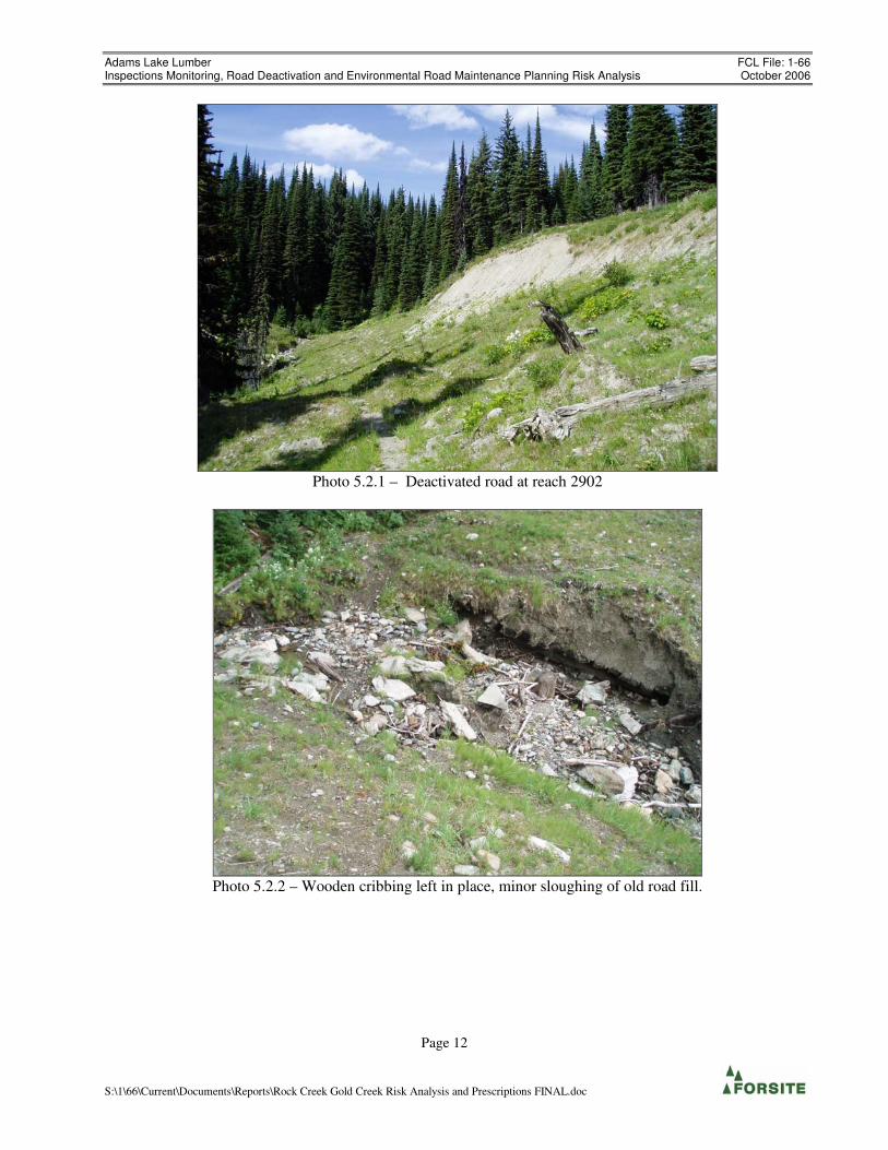
5.2 Gold Creek – Site B (Reach 2902)
Location: Gold Creek, Reach 2902,
Map Reference: G-2902
Previously identified issues Fillslope failure and unstable cutslopes in fine grained soils contributing sediment to stream (Silvatech 1998).
Restoration undertaken Road has been relocated, old road pulled back and hydroseeded / bio-engineered.
Observations The road has been bypassed, and the site has been fully recontoured. Grass seeding was partially successful,
having taken on the recontoured road, though not on the upper portion of old cutslopes (Photo plate 5.2.1).
Bio-remediation attempts were unsuccessful (Photo 5.2.3) and the site has not yet revegetated. The former
bridge (log box?) at the stream crossing has been removed, though cribbing was left in place. The stream
appears to be stable. Only minor amounts of sediment from the old road location appears currently to be
entering the stream at high streamflows, where some material may be entrained at the crossing.
Risk Analysis There is judged to be a moderate likelihood of sediment producing events (small surficial slides, rilling) at
this site. This would result in a small amount (< 5m3) of material mobilised at the stream crossing during a
peak flow event and from small erosional events on the unvegetated upper cutslope. This would be considered
a low consequence. The risk is therefore low.
Prescription
• Bioengineering of slopes recommended to further stabilise the area as per (Silvatech 1998) Report.
• Consider planting area with coniferous species
• Hand grass seed the remaining open slopes
Adams Lake Lumber FCL File: 1-66 Inspections Monitoring, Road Deactivation and Environmental Road Maintenance Planning Risk Analysis October 2006
Page 12
S:\1\66\Current\Documents\Reports\Rock Creek Gold Creek Risk Analysis and Prescriptions FINAL.doc
Photo 5.2.1 – Deactivated road at reach 2902
Photo 5.2.2 – Wooden cribbing left in place, minor sloughing of old road fill.

Adams Lake Lumber FCL File: 1-66 Inspections Monitoring, Road Deactivation and Environmental Road Maintenance Planning Risk Analysis October 2006
Page 13
S:\1\66\Current\Documents\Reports\Rock Creek Gold Creek Risk Analysis and Prescriptions FINAL.doc
Photo 5.2.3 – Evidence of unsuccessful bio-remediation.

Adams Lake Lumber FCL File: 1-66 Inspections Monitoring, Road Deactivation and Environmental Road Maintenance Planning Risk Analysis October 2006
Page 14
S:\1\66\Current\Documents\Reports\Rock Creek Gold Creek Risk Analysis and Prescriptions FINAL.doc
5.3 Gold Creek – Reach 0106
Location: Gold Creek, Reach 0106
Map Reference: G-0106
Previously identified issues Severely aggraded active channel, deposition area/ sediment wedge above bedrock constriction.
Restoration undertaken None reported. Previous prescriptions suggest monitoring and controlling sediment input from upstream.
Observations The stream is heavily aggrading, with multiple channels and significant lateral movement where the channel is
not confined by bedrock. Numerous log jams were noted along this reach. There is no sign of direct
connectivity to the road system. Problems in this area are symptomatic of overall hydrologic conditions in the
watershed.
Risk Analysis No risk analysis was performed at this site. A risk analysis for this reach would be a function of hydrology of
entire watershed, which is beyond the scope of this study.
Prescription
• Continue to monitor drainage issues in the watershed / control sediment sources in previously
developed areas.
Photo 5.3.1 – Aerial view of reach 0106 showing severe aggradation.

Adams Lake Lumber FCL File: 1-66 Inspections Monitoring, Road Deactivation and Environmental Road Maintenance Planning Risk Analysis October 2006
Page 15
S:\1\66\Current\Documents\Reports\Rock Creek Gold Creek Risk Analysis and Prescriptions FINAL.doc
5.4 Gold Creek – Reach 0134 / 7902
Location: 523-100 Road [~2.5 km]
Map Reference: G-0134
Field Identification: ∆206-∆221
Previously identified issues A spur road has diverted flows from upslope leading to slope failures below (Silvatech 1998).
Restoration undertaken Natural drainage patterns have been restored, spur and branch roads deactivated.
Observations The upper spur road has been thoroughly deactivated with numerous cross drains. The natural flow of the
main drainage path has been restored. Large cross ditches effectively prevent further diversion on the upper
spur road. Some intercepted small flows on the upper spur have been diverted to cross drain culverts on the
100 Road. The crossing at the upper road is well armoured, with some very minor sediment input from
ravelling road fills. Some drainage intercepted by lower road and 600CMP at ∆218. There is evidence of
previously large flows in the ditchline on the lower road. The lower stream crossing at ∆220 is eroding some
fill material.
Aerial observations – the slide has partially naturally revegetated. The site is likely still a significant sediment
source as it is adjacent to Gold Creek. Bio-engineering and seeding should be carried out as per the
prescription in Silvatech (1998) report.
Risk Analysis As the natural drainage patterns have been restored, there is judged to be a low likelihood of initiating another
large landslide which could impact Gold Creek at this site. Such a slide would result from drainage diversion
and concentration in a ‘gentle over steep’ type of scenario as happened with the previous slide. This would
result in significant input of sediment to Gold Creek, and result in long-term sediment source production. This
is considered a high consequence. The risk is therefore moderate
There is a moderate to high likelihood of further sediment mobilisation on the old slide path, with sediment
delivery of <25m3 to Gold Creek. This would result in input of a small to moderate (to 25m
3) amount of
sediment to Gold Creek, which would be considered a moderate to high consequence. The risk is therefore
moderate to high.
Prescription
• If the 100 Road is to continue to remain operational, monitor exiting culverts and restoration efforts on
the road to ensure continued functioning. If no future use of the road is anticipated, permanent
deactivation should be considered (i.e. pull all culverts)
• Revegetate slide as per Silvatech (1998) bioremediation prescription.

Adams Lake Lumber FCL File: 1-66 Inspections Monitoring, Road Deactivation and Environmental Road Maintenance Planning Risk Analysis October 2006
Page 16
S:\1\66\Current\Documents\Reports\Rock Creek Gold Creek Risk Analysis and Prescriptions FINAL.doc
Photo 5.4.1 – ∆220 Stream crossing

Adams Lake Lumber FCL File: 1-66 Inspections Monitoring, Road Deactivation and Environmental Road Maintenance Planning Risk Analysis October 2006
Page 17
S:\1\66\Current\Documents\Reports\Rock Creek Gold Creek Risk Analysis and Prescriptions FINAL.doc
Photo 5.4.2 – Lower portion of slide entering Gold Creek

Adams Lake Lumber FCL File: 1-66 Inspections Monitoring, Road Deactivation and Environmental Road Maintenance Planning Risk Analysis October 2006
Page 18
S:\1\66\Current\Documents\Reports\Rock Creek Gold Creek Risk Analysis and Prescriptions FINAL.doc
5.5 Gold Creek – Reach 1901
Location: Tributary 250m upslope of Reach 1901 of Gold Creek
Map Reference: G-1901
Previously identified issues Collapsed bridge on old road has diverted flows south along road, through forested area and into Gold Creek.
Deposition of materials in forested area.
Restoration undertaken Collapsed culvert has been removed, berm constructed and planted with dogwood.
Observations Observation from helicopter overflight revealed no further disturbance of tributary channel.
Risk Analysis There is judged to be a low likelihood of a future breach of the stream channel as a result of the old road
location, which could result in minor sediment deposition into gold Creek. This is considered a moderate
consequence. The risk is therefore low.
Prescription
• None required

Adams Lake Lumber FCL File: 1-66 Inspections Monitoring, Road Deactivation and Environmental Road Maintenance Planning Risk Analysis October 2006
Page 19
S:\1\66\Current\Documents\Reports\Rock Creek Gold Creek Risk Analysis and Prescriptions FINAL.doc
5.6 Gold Creek – Reach 3801
Location: Gold Creek Reach 3801,
Map Reference: G-3801
Field Identification: ∆203
Previously identified issues Large log jam/pile at bottom of slide, perched fills at deactivated road crossing (∆203).
Restoration undertaken Road crossing has been deactivated. Upper road at initiation point of failure has been deactivated.
Observations Crossing at lower road still has some minor perched fills present, though the crossing has been sloped back and
rehabilitated. Current flow is crossing over old road surface in a ‘self-armoured’ channel – no sign of recent
disturbance. Road surface is revegetating (grass seeding effective). Some perched fills are still present but
most material appears to have been pulled back in critical areas. Sediment mobilisation is not likely to be a
catastrophic failure but rather a progressive erosion of fill materials.
Risk Analysis There is judged to be a moderate likelihood of a mobilisation of
road fill materials, resulting in transport of
fine sediment (<5m3) to the tributary of Gold Creek. This is considered a low consequence. The risk is
therefore low.
Prescription
� No further work required / continue to monitor

Adams Lake Lumber FCL File: 1-66 Inspections Monitoring, Road Deactivation and Environmental Road Maintenance Planning Risk Analysis October 2006
Page 20
S:\1\66\Current\Documents\Reports\Rock Creek Gold Creek Risk Analysis and Prescriptions FINAL.doc
Photo 5.6.1 – Stream crossing old road.

Adams Lake Lumber FCL File: 1-66 Inspections Monitoring, Road Deactivation and Environmental Road Maintenance Planning Risk Analysis October 2006
Page 21
S:\1\66\Current\Documents\Reports\Rock Creek Gold Creek Risk Analysis and Prescriptions FINAL.doc
5.7 Gold Creek – Reach 4700 / 4601
Location: Road upslope of Reach 4700, and bridge crossing of Reach 4601
Map Reference: G-4700 / G-4601
Field Identification: ∆122
Previously identified issues Creek diverted by old skid trail and mainline. Failure 300m below mainline and channelized debris flow into
Gold Creek.
Restoration undertaken Natural drainage was restored on mainline, 500mm culvert installed. Failure was grass seeded.
Observations The slide headwall and main portion of the slide is revegatating and appears to be stabilising – some sidewall
failures are taking place on the channelized portion of the slide. Some coniferous vegetation is starting to re-
establish. Material had been scoured to bedrock in track of the slide, and remobilisation is unlikely. On the
eastern side of the headwall, there is significant flow emanating at the base, with soil materials perched
upslope. There remains the possibility that further headward erosion will continue. The area upslope of the
slide (∆121) and to the south of the main slide have a number of old revegetated slide scarps present.
At ∆122, the road cuts through a rock outcrop, and as a result the ditchline is very shallow and prone to
overflowing onto the road. Evidence of water flow downslope suggests that this may be a point at which some
water had previously been diverted to the slide. The drainage diversions identified in the Silvatech 1998 report
have been restored.
Risk Analysis Drainage diversions upslope have been repaired, however natural drainage is seeping from the headwall of the
scarp. There is judged to be a low to moderate likelihood of further sliding of material at the landslide site,
resulting in delivery of <25m3 of material to the reach and a moderate likelihood of delivery to Gold Creek.
This is considered a moderate consequence. The risk is therefore low to moderate.
Prescription
• Monitor and maintain ditchline on road / Improve ditchline through ∆117
• Allow slide area to revegetate naturally.

Adams Lake Lumber FCL File: 1-66 Inspections Monitoring, Road Deactivation and Environmental Road Maintenance Planning Risk Analysis October 2006
Page 22
S:\1\66\Current\Documents\Reports\Rock Creek Gold Creek Risk Analysis and Prescriptions FINAL.doc
Photo 5.7.1 – View up headwall of slide
Photo 5.7.2 – View down slide path

Adams Lake Lumber FCL File: 1-66 Inspections Monitoring, Road Deactivation and Environmental Road Maintenance Planning Risk Analysis October 2006
Page 23
S:\1\66\Current\Documents\Reports\Rock Creek Gold Creek Risk Analysis and Prescriptions FINAL.doc
5.8 Gold Creek – Reach 6402
Location: Spur in Block 81-1
Map Reference: G-6204
Field Identification: ∆124-128
Previously identified issues Stream diverted by skid trail.
Restoration undertaken Stream restored to original channel. Roads and trails deactivated.
Observations The point of diversion by the old skid trail has been restored and the stream is now flowing in what appears to
be the original channel. The diversion has been blocked by a vegetated berm, however water is seeping
through this berm and still flowing down the skid trail. There is a low to moderate likelihood that a large
streamflow could ovetop the structure and again be diverted by the skid trail. In some areas the skid trail is at a
lower elevation than the natural stream draw. ∆128 is a low point on the trail.
Some seepage is emanating on the road at ∆124. This appears to be an area where some of the stream flow is
diverted, primarily as subsurface flows, to the road. There is no cross drain structure here, and water flows
down the ditch to pond on the high side of the road at the junction of the deactivated road downslope, resulting
in wet road conditions. There is a 400mm CMP which takes the flow at ∆126 across the mainline.
Risk Analysis There is judged to be a low to moderate likelihood of a stream avulsion at the previous point of diversion,
resulting in flows being diverted down the skid trail, entrainment of fine materials at the road crossing and
subsequent delivery to the stream system to the north. This would also result in the loss of a small amount of
productive area. This is considered a low to moderate consequence. The risk is therefore low to moderate.
Prescription
• Upgrade berm by hand, increasing height by ~0.3m, and width by about 1m, with locally available
rock.
• Monitor berm on skid trail for future avulsions.
• Improve ditchline to ∆126 (400mm CMP), clean sump.

Adams Lake Lumber FCL File: 1-66 Inspections Monitoring, Road Deactivation and Environmental Road Maintenance Planning Risk Analysis October 2006
Page 24
S:\1\66\Current\Documents\Reports\Rock Creek Gold Creek Risk Analysis and Prescriptions FINAL.doc
Photo 5.8.1 – Aerial view of site
Photo 5.8.2 – ∆124 seepage onto road
Diverted stream flow along skid trail and ditchline
Natural stream channel

Adams Lake Lumber FCL File: 1-66 Inspections Monitoring, Road Deactivation and Environmental Road Maintenance Planning Risk Analysis October 2006
Page 25
S:\1\66\Current\Documents\Reports\Rock Creek Gold Creek Risk Analysis and Prescriptions FINAL.doc
Photo 5.8.3 – ∆127 There is still some minor drainage along the old skid trail (left).
(photo taken from top of berm.)

Adams Lake Lumber FCL File: 1-66 Inspections Monitoring, Road Deactivation and Environmental Road Maintenance Planning Risk Analysis October 2006
Page 26
S:\1\66\Current\Documents\Reports\Rock Creek Gold Creek Risk Analysis and Prescriptions FINAL.doc
5.9 Gold Creek – Reach 6207 / 6208
Location: Block 81-1
Map Reference: G-6207 / G-6208
Field Identification: ∆126
Previously identified issues: (6207) Stream diverted by skid trail, no riparian buffer maintained through block.
(6208)Stream diverted by skid trail causing ‘twin channels’. Poorly defined channel at mainline crossing, some
flows follow ditch south.
Restoration undertaken (6207) Stream restored to original channel, roads and trails deactivated.
(6208) Culvert entrance and ditch grading improved, channel definition improved near culvert
Observations Streams have been restored to original flows. Skid trail that had been an issue on 6207 is revegetating.
Culvert functioning well.
Risk Analysis There is judged to be a low to negligible likelihood of further diversions at these two sites.
Prescription
• No further works required
Photo 5.9.1 – Culvert 6208

Adams Lake Lumber FCL File: 1-66 Inspections Monitoring, Road Deactivation and Environmental Road Maintenance Planning Risk Analysis October 2006
Page 27
S:\1\66\Current\Documents\Reports\Rock Creek Gold Creek Risk Analysis and Prescriptions FINAL.doc
Photo 5.9.2 – Reach 6208

Adams Lake Lumber FCL File: 1-66 Inspections Monitoring, Road Deactivation and Environmental Road Maintenance Planning Risk Analysis October 2006
Page 28
S:\1\66\Current\Documents\Reports\Rock Creek Gold Creek Risk Analysis and Prescriptions FINAL.doc
5.10 Gold Creek – Reach 7001
Location: Reach 7001
Map Reference: G-7001
Field Identification: ∆129-∆130
Previously identified issues Creek was temporarily diverted by skid trail, deposition at culvert inlet.
Restoration undertaken Creek restored to natural channel, inlet cleaned.
Observations The point of diversion was repaired, the stream appears to currently be taking about 90% of the flow. There is
still some minor diversion taking place along the old skid trail. Diverted flow returns to channel downstream.
Risk Analysis There is judged to be a low likelihood of recurrence of a stream avulsion at this site. This would resulting in
streamflow being diverted by the skid trail with some minor sediment entrainment. Sediment is not likely to
reach a fish bearing stream. This is considered a low consequence. The risk is therefore low.
Prescription Potential disturbance by machine likely to be more disruptive than leaving the site undisturbed. Restoration
(cross-ditching) could be conducted by hand, however the majority of the flow is likely to stay in the natural
channel.
• Cross drain flow on trail back to stream draw by hand.
• Install wide shallow swale (culvert backup) at stream crossing ∆130.

Adams Lake Lumber FCL File: 1-66 Inspections Monitoring, Road Deactivation and Environmental Road Maintenance Planning Risk Analysis October 2006
Page 29
S:\1\66\Current\Documents\Reports\Rock Creek Gold Creek Risk Analysis and Prescriptions FINAL.doc
Photo 5.10.1– Stream looking towards road. Direction of diversion along old skid trail indicated.

Adams Lake Lumber FCL File: 1-66 Inspections Monitoring, Road Deactivation and Environmental Road Maintenance Planning Risk Analysis October 2006
Page 30
S:\1\66\Current\Documents\Reports\Rock Creek Gold Creek Risk Analysis and Prescriptions FINAL.doc
5.11 Gold Creek – Reach 7203
Location: Road in Block 509-2
Map Reference: G-7203
Field Identification: ∆204
Previously identified issues Streams had been diverted by skid trails in the block, culverts washed out, deposition downstream.
Restoration undertaken Diversions have been restored by hand, road deactivated.
Observations Streams at road crossing have stabilised, and are well incised. Swales at stream crossing are revegetating.
There is some minor lateral erosion of road fill materials at crossings, but this is expected to decrease as
riparian vegetation re-establishes.
Risk Analysis There is judged to be a low to negligible likelihood of mobilising sufficient sediment to impact a fish bearing
reach of the Gold Creek from this site.
Prescription
• No works required
Photo 5.11.1 – Stream crossing reach 7203

Adams Lake Lumber FCL File: 1-66 Inspections Monitoring, Road Deactivation and Environmental Road Maintenance Planning Risk Analysis October 2006
Page 31
S:\1\66\Current\Documents\Reports\Rock Creek Gold Creek Risk Analysis and Prescriptions FINAL.doc
5.12 Gold Creek – Reach 7205
Location: Reach 7205 at road crossing
Map Reference: G-7205
Previously identified issues Creek diverted by skid trails, hazard of diversion along mainline.
Restoration undertaken Channel restored, culvert improved.
Observations Deflector berm and culvert have been upgraded – no issues at crossing.
Risk Analysis There is judged to be a low to negligible likelihood of mobilising sufficient sediment to impact a fish bearing
stream from this site.
Prescription
• No further works required.
Photo 5.12.1 – Reach 7205 at road crossing

Adams Lake Lumber FCL File: 1-66 Inspections Monitoring, Road Deactivation and Environmental Road Maintenance Planning Risk Analysis October 2006
Page 32
S:\1\66\Current\Documents\Reports\Rock Creek Gold Creek Risk Analysis and Prescriptions FINAL.doc
5.13 Gold Creek – Reach 7604
Location: Reach 604 in Block 523-2
Map Reference: G-7604
Field Identification: ∆134
Previously identified issues No riparian buffer in block, slash in streams, blocked and damaged culvert.
Restoration undertaken None
Observations 600mm CMP in place, functioning. There is evidence of significant flows in this draw. Riparian area well
vegetated and regrowing. Soils in this area are rocky and free draining. No immediate concerns as long as
culvert remains functional.
Risk Analysis Given the past history of plugging, and evidence of significant seasonal flows in this stream, there is a
moderate likelihood that this culvert will become plugged or fail, leading to a washout of the road and
subsequent sediment delivery to the stream system. There is a moderate likelihood of material being delivered
downstream to Gold Creek. This would be considered a moderate consequence. The risk is therefore
moderate.
Prescription
• Pull culvert / construct broad armoured swale with planned road deactivation, or install failsafe cross
ditch as per Silvatech (1998) prescription.
Photo 5.13.1 – Crossing at Reach 7604

Adams Lake Lumber FCL File: 1-66 Inspections Monitoring, Road Deactivation and Environmental Road Maintenance Planning Risk Analysis October 2006
Page 33
S:\1\66\Current\Documents\Reports\Rock Creek Gold Creek Risk Analysis and Prescriptions FINAL.doc
Photo 5.13.2 – 600 mm CMP at Reach 7604 crossing

Adams Lake Lumber FCL File: 1-66 Inspections Monitoring, Road Deactivation and Environmental Road Maintenance Planning Risk Analysis October 2006
Page 34
S:\1\66\Current\Documents\Reports\Rock Creek Gold Creek Risk Analysis and Prescriptions FINAL.doc
5.14 Gold Creek – Site 1
Location: Road in Block 502-3
Map Reference: G-1
Field Identification: ∆115
Previously identified issues Damaged and blocked 300mm culvert, road requires deactivation. (Silvatech 2004)
Restoration undertaken None
Observations Crushed and mangled culvert still in place. There is evidence of significant ditch flow in the past (foreground
in photo). The culvert is at a low point in the road, with ponding water on the high side.
Risk Analysis This site is on flat to gently sloping plateau. There is judged to be a low to negligible likelihood that
significant drainage diversion could take place at this site.
Prescription
• Remove culvert and install cross ditch. This can be done with deactivation on the remainder of the
road.
Photo 5.14.1 – Crushed culvert.

Adams Lake Lumber FCL File: 1-66 Inspections Monitoring, Road Deactivation and Environmental Road Maintenance Planning Risk Analysis October 2006
Page 35
S:\1\66\Current\Documents\Reports\Rock Creek Gold Creek Risk Analysis and Prescriptions FINAL.doc
5.15 Gold Creek – Site 7
Location: Road in Block 522-3
Map Reference: G-7
Field Identification: ∆201
Previously identified issues Deck material rotting, but crib wall and stringers look in good shape. (Silvatech 2004)
Restoration undertaken None
Observations Deck on the bridge is rotting out. There has been a small slide to the northwest of the bridge in the road cut
(see photo 5.15.1). No significant amount of debris has entered the stream as a result, however several trees
have been uprooted and are threatening to fall onto the bridge deck / upstream of the bridge which may result
in a temporary blockage.
The cribbing on the downstream side of the town side approach is beginning to erode. The stream gradient
downslope is 80% for about 7m immediately after the crossing. A blockage / collapse of the structure may lead
to alteration of flow and/or significant erosion of the stream bed and / or mobilisation of debris downslope.
The bridge could likely be left in place for some time before significant problems arise, however a high flow
event or mass movement event in the channel may accelerate deterioration and lead to significant sediment
input.
Note: Reach 4700 is located upslope of this bridge. There is no evidence of the debris flow reaching this
location.
Risk Analysis There is judged to be a low likelihood of a structural failure on this bride (cribbing collapse / creek blockage)
within the next 20 years that could result in significant sediment delivery to Gold Creek. This is considered a
high consequence. The risk is therefore moderate.
Prescription
• Bridge superstructure and cribbing should be removed, and approaches sloped back and revegetated.
• Pull back all materials adjacent the creek to create a broad swale, and armour stream crossing with
coarse rock
• Remove material slumping into creek at road cut
• Supervision of deactivation works by a qualified registered professional is recommended.

Adams Lake Lumber FCL File: 1-66 Inspections Monitoring, Road Deactivation and Environmental Road Maintenance Planning Risk Analysis October 2006
Page 36
S:\1\66\Current\Documents\Reports\Rock Creek Gold Creek Risk Analysis and Prescriptions FINAL.doc
Photo 5.15.1 – Log Bridge, ∆201 (Silvatech 1998 “Site 7”)
Photo 5.15.2 – Log Bridge, ∆201 (Silvatech 1998 “Site 7”) SE corner of Cribbing starting to collapse.

Adams Lake Lumber FCL File: 1-66 Inspections Monitoring, Road Deactivation and Environmental Road Maintenance Planning Risk Analysis October 2006
Page 37
S:\1\66\Current\Documents\Reports\Rock Creek Gold Creek Risk Analysis and Prescriptions FINAL.doc
5.16 Gold Creek – Site 8
Location: Bridge at crossing between blocks 522-2 and 522-3
Map Reference: G-8
Field Identification: ∆202
Previously identified issues Bridge, “Site 8”. No significant issues identified – guardrails were beginning to rot. Silvatech (1998)
Restoration undertaken None
Observations Bridge is showing significant rot, but no sign of imminent collapse. Bridge will likely remain intact for a
number of years, but continued degradation will compromise load bearing capacity.
Risk Analysis There is judged to be a low likelihood of a structural failure on this bridge that would result in delivery of a
small to moderate amount of sediment to the stream, considered a low to moderate consequence. The risk is
therefore low.
Note: This bridge will continue to deteriorate, holes have formed in the deck and the structure may become
unsafe to use in the next 20 years. The bridge may not be safe for vehicular traffic. If this bridge is to remain,
a load rating should be performed.
Prescription
This bridge will not support machinery. Works planned for site 7 require removal of this bridge for access.
• Bridge superstructure and cribbing should be removed.
• Pull back all materials adjacent the creek to create a broad swale, and armour stream crossing with
coarse rock
• Supervision of deactivation works by a qualified registered professional is recommended.

Adams Lake Lumber FCL File: 1-66 Inspections Monitoring, Road Deactivation and Environmental Road Maintenance Planning Risk Analysis October 2006
Page 38
S:\1\66\Current\Documents\Reports\Rock Creek Gold Creek Risk Analysis and Prescriptions FINAL.doc
Photo 5.16.1 – Bridge at ∆202, (“Site 8” in Silvatech 1998 report)

Adams Lake Lumber FCL File: 1-66 Inspections Monitoring, Road Deactivation and Environmental Road Maintenance Planning Risk Analysis October 2006
Page 39
S:\1\66\Current\Documents\Reports\Rock Creek Gold Creek Risk Analysis and Prescriptions FINAL.doc
5.17 Gold Creek – Site 9 / 10
Location: Block 502-3 Road
Map Reference: G-9, G-10
Field Identification: ∆113, ∆114
Previously identified issues (9) Failed 400mm CMP, water running along road surface, then back into natural channel.
(10) Infilled ditch is causing creek to flow down the road.
Restoration undertaken None
Observations A number of diversions of natural drainage paths along the road system were observed. This road system
should be deactivated and have natural drainage patterns restored.
These sites are not part of the Gold Creek watershed and drain to the watershed to the west. This road system
has not been deactivated, and though no significant issues were identified at the specific sites addressed in this
report, ( 9 and 10) the entire road system accessing Blocks 502 1-6 should be assessed in detail and
deactivated. These roads and blocks are located on the plateau, with drainage to the west into a deeply incised
creek draw. The draw is mapped as terrain class IV and V (potentially unstable and unstable).
Risk Analysis There is judged to be a moderate likelihood that improper drainage management in this entire road system
(including sites 9 and 10) could lead to drainage diversions which would result in landslides in the class IV and
V terrain in the watershed downslope (to the east). This could result in significant disturbances in the
watershed and subsequent downstream effects on Adams Lake. This is considered a high consequence. The
risk is therefore high.
Prescription
• At stations ∆113, ∆114 and ∆115 (corresponding to the area of Silvatech (2004) sites 9 and 10),
culverts should be removed and cross ditched.
• This entire road system associated with Blocks 502 (1-6) should have a deactivation prescription
prepared as it presents a possible gentle-over-steep hazard. (note: Preparation of deactivation
prescriptions for this area are planned for Summer of 2007)

Adams Lake Lumber FCL File: 1-66 Inspections Monitoring, Road Deactivation and Environmental Road Maintenance Planning Risk Analysis October 2006
Page 40
S:\1\66\Current\Documents\Reports\Rock Creek Gold Creek Risk Analysis and Prescriptions FINAL.doc
Photo 5.17.1 – Blocked culvert causing ponding in ditchline with seasonal runoff over road.
Photo 5.17.2 – Damaged culvert at “Site 9” (∆114)

Adams Lake Lumber FCL File: 1-66 Inspections Monitoring, Road Deactivation and Environmental Road Maintenance Planning Risk Analysis October 2006
Page 41
S:\1\66\Current\Documents\Reports\Rock Creek Gold Creek Risk Analysis and Prescriptions FINAL.doc
5.18 Rock Creek – Site 1
Location: Forest Service Rec. Site (“Silviculture Camp”) at Tsikwustum (Rock) Creek.
Map Reference: R-1
Field Identification: ∆52, ∆53
Previously identified issues Considerable bank erosion along right bank adjacent to rec site.
Potential to loose rec. site land, sediment delivery to creek and lake.
Restoration undertaken Unstable bank material was excavated back, and separated boulders placed as armour at the toe of the bank and
the area was grass seeded.
Observations The forest recreation site is located on the right bank of Tsikwustum (Rock) Creek, at the mouth of the river on
Adams Lake. This recreation site is built on an active fan, and as such is subject to large debris flood events,
and large annual high flow events.
There is a 1-4m high bank along the edge of the site (see composite photo 5.18.1) that had been sloped back
and armoured in 2004. The bank is being eroded and there is undercut portion of this bank adjacent to the
recreation site. Toe protection on the bank appears inadequate, as further erosion has taken place (compared to
2004 photos). Erosion is being accelerated by human activities; there is evidence in this area of disturbance by
campers (walking access, digging). A large open grassy area (grass seeded in 2004) is located adjacent to the
bank, as well as an access route to one of the lower camp sites.
Note: A large flood event could significantly impact the camp site. This assessment addresses only on the
possibility of sediment delivery to the creek as a function of normal (annual) high flows at the site indicated in
the Silvatech (2004) report. No evaluation of risk to the site infrastructure or human life is made with respect
to large, low return period flood events. Such an assessment is likely warranted, and should be carried out
separately.
Risk Analysis There is judged to be a moderate to high likelihood of further erosion along this slope, resulting in delivery of
sandy material to Rock Creek. This is likely to occur during flood / high water events, and would be
significantly diluted. This is therefore considered a low to moderate consequence. The risk is therefore
moderate to high
Prescription
• Slope back steep section (blue arrows in photo 5.18.1) where overhang and exposed roots threaten to
collapse.
• Place large rip rap (~2m diameter) at the base of the section ∆52 to ∆53, slope back top of the bank and
grass seed.
• Restrict vehicle access at the top of the bank by placing a row of large boulders ~ 5m back from the top
of the break in slope
• Consider restricting access with a fence along the top bank leaving a well marked path to the river to
limit bank disturbance.
• Continue to monitor site, inspect after high flow events.

Adams Lake Lumber FCL File: 1-66 Inspections Monitoring, Road Deactivation and Environmental Road Maintenance Planning Risk Analysis October 2006
Page 42
S:\1\66\Current\Documents\Reports\Rock Creek Gold Creek Risk Analysis and Prescriptions FINAL.doc
Photo 5.18.1 – Photo composite – Eroding bank of Rock Creek adjacent to Silviculture Camp Forest Rec. Site.
Photo 5.18.2 – Detail of eroding bank.
∆∆∆∆52
∆∆∆∆53

Adams Lake Lumber FCL File: 1-66 Inspections Monitoring, Road Deactivation and Environmental Road Maintenance Planning Risk Analysis October 2006
Page 43
S:\1\66\Current\Documents\Reports\Rock Creek Gold Creek Risk Analysis and Prescriptions FINAL.doc
5.19 Rock Creek – Site 2
Location: Tributary to Rock Creek
Map Reference: R-2
Field Identification: ∆51
Previously identified issues 1800 mm CMP plugged with woody debris. Cutslope to the east (bush side of crossing) is delivering fine
sediment
Restoration undertaken Culvert has been cleared
Observations Culvert log jam has been cleared, and is now unobstructed. Given the size of this creek, there is a moderate to
high likelihood that future jams will take place. The recommendations in the Silvatech (2003) report to inspect
the culvert frequently (twice per year); this should be done prior to and following freshet. A large jam could
cause a significant blockage and subsequent debris flow at this site that would impact the S3 reach of Rock
Creek downstream.
The large cutslope to the east of the site continues to ravel and has infilled the ditchline, causing ditch flows to
flow across the road and onto the fillslopes on the bush side of the crossing (see photo 5.19.1 ; blue arrow
indicates flow). This is leading to erosion of the fillslope and deposition of sediment into the stream. If this
condition persists, it could lead to more significant erosion and / or fillslope failures.
Risk Analysis There is judged to be a moderate likelihood of a significant washout of the road, resulting in significant
sediment delivery and possibly a debris flow in the creek. This is considered a high consequence. The risk is
therefore high
Prescription
• Inspect culvert regularly (twice per year; prior to and following freshet)
• Clean and widen ditchline, carry flow to crossing (red arrow in Figure 5.19.1)
• Grass seed ditch and cutslope by hand or optionally hydroseed slope if feasible as per Silvatech (2003)
.

Adams Lake Lumber FCL File: 1-66 Inspections Monitoring, Road Deactivation and Environmental Road Maintenance Planning Risk Analysis October 2006
Page 44
S:\1\66\Current\Documents\Reports\Rock Creek Gold Creek Risk Analysis and Prescriptions FINAL.doc
Photo 5.19.1 – Rock Creek tributary (Site 2 Silvatech 2003) ∆51 in field
Photo 5.19.2 – Rock Creek tributary culvert inlet

Adams Lake Lumber FCL File: 1-66 Inspections Monitoring, Road Deactivation and Environmental Road Maintenance Planning Risk Analysis October 2006
Page 45
S:\1\66\Current\Documents\Reports\Rock Creek Gold Creek Risk Analysis and Prescriptions FINAL.doc
5.20 Rock Creek – Site 3
Location: Slide S-19 downslope of Rock Creek road near bridge crossing
Map Reference: R-3
Field Identification: ∆50
Previously identified issues Surface soils in slide susceptible to surface erosion, sediment delivery potential to creek is high.
Restoration undertaken Has been hand grass seeded several times.
Observations The slide location is at a low point on the road, there is a long ditch run to this point, and water likely had
saturated the road prism / run over the edge at the slide site. Perched fill materials are still present and are
prone to ravelling. The slide is partially revegetating, some grass seeding has taken on the lower portions, but
the steep upper portion is likely to continue to be a sediment source. Rock Creek (S2) is located directly
downslope.
Risk Analysis The site is a permanent sediment source because slopes at the top are too steep to revegetate. There is judged
to be a moderate likelihood of a small slide initiating on oversteepened materials at the headscarp of the slide
with resulting minor sediment delivery (<5m3) to the S-2 creek downslope. This is considered a moderate
consequence. The risk is therefore moderate.
Prescription
• Carefully pull back top of slide area to 1.5V:1H (66%) maximum slope for the top portion of the slide.
• Hand-grass seed the slope.
• Upgrade ditchline along road this site.

Adams Lake Lumber FCL File: 1-66 Inspections Monitoring, Road Deactivation and Environmental Road Maintenance Planning Risk Analysis October 2006
Page 46
S:\1\66\Current\Documents\Reports\Rock Creek Gold Creek Risk Analysis and Prescriptions FINAL.doc
Photo 5.20.1 - ∆50, slide S-19 looking down at exposed soils.

Adams Lake Lumber FCL File: 1-66 Inspections Monitoring, Road Deactivation and Environmental Road Maintenance Planning Risk Analysis October 2006
Page 47
S:\1\66\Current\Documents\Reports\Rock Creek Gold Creek Risk Analysis and Prescriptions FINAL.doc
5.21 Rock Creek – Site 4
Location: Non-status road near reach break 5/6
Map Reference: R-4
Field Identification: ∆4
Previously identified issues Erosion along 9m length of left bank of road poses a risk to the road and is a minor sediment source to the
creek.
Restoration undertaken Done as per Silvatech (2003) report
Observations This is a broad low gradient reach, with significant coarse woody debris in creek. Comparison of pictures of
previous site suggests low debris movement. Stream is classed as S2. Site has been restored, and remaining
ravelling is expected to be very minor. Site is revegetating, road surface erosion has ceased.
Risk Analysis There is judged to be a low to negligible likelihood of delivery of significant sediment to Rock Creek at this
site.
Prescription
• None / continue to monitor site.

Adams Lake Lumber FCL File: 1-66 Inspections Monitoring, Road Deactivation and Environmental Road Maintenance Planning Risk Analysis October 2006
Page 48
S:\1\66\Current\Documents\Reports\Rock Creek Gold Creek Risk Analysis and Prescriptions FINAL.doc
5.22 Rock Creek – Site 5
Location: Non status road (Tsikwustum Lake Road) near junction with
Branch “C” Block C-206.
Map Reference: R-5
Field Identification: ∆44
Previously identified issues Erosion of road surface near 450mm CMP due to plugged inlet – 50% function only.
Restoration undertaken None (Pre work indicated done)
Observations The ditch block at the 450mm culvert has failed, and flow has eroded ditchline. Drainage flows through
1000mm CMP downstream. There is significant flow coming down the ditchline that has eroded the
ditchblocks of the culverts upstream, and has resulted in significant sediment mobilisation (photo 5.22.1) in the
ditch and subsequent deposition (photo 5.22.2) in the ditch at lower gradient areas. Sediment is being
transported downstream, with significant aggradation in the channel and fines washing into Rock Creek.
Restoration at this site should be done in conjunction with remainder of the road to the east (Sites 6 and 7).
The culvert is experiencing severe piping because of excessive flows at this site, and material is eroding at the
outlet.
Risk Analysis There is judged to be a high likelihood that the culvert at this site will continue to fail and erode sediment
form the outlet and road surface. This will result in significant fine sediment transport downstream to Rock
Creek. This is considered a high consequence. The risk is therefore high
Prescription
• Repair (re-install) culvert (600mm CMP minimum) and armour sump.
• Ensure drainage measures in ditch upstream are addressed.
• Repair in conjunction with Site 11 (R-11) deactivation.

Adams Lake Lumber FCL File: 1-66 Inspections Monitoring, Road Deactivation and Environmental Road Maintenance Planning Risk Analysis October 2006
Page 49
S:\1\66\Current\Documents\Reports\Rock Creek Gold Creek Risk Analysis and Prescriptions FINAL.doc
Photo 5.22.1 Erosion of ditchline
Photo 5.22.2 - Significant deposition at low point before culvert.

Adams Lake Lumber FCL File: 1-66 Inspections Monitoring, Road Deactivation and Environmental Road Maintenance Planning Risk Analysis October 2006
Page 50
S:\1\66\Current\Documents\Reports\Rock Creek Gold Creek Risk Analysis and Prescriptions FINAL.doc
5.23 Rock Creek – Site 6
Location: Non status road (Tsikwustum Lake Road)
Map Reference: R-6
Field Identification: ∆42
Previously identified issues Non functioning culvert is filly suspended above ditch, which has downcut ~0.4m in sandy materials.
Restoration undertaken None (Pre work indicated done, but comparison to Silvatech report photos reveals site has not been repaired)
Observations Culvert is still fully suspended and ditchblock has not been repaired. This is resulting in severe ditch runs
downstream, scouring ditchline and transporting sediment to Site 5, and subsequently to Rock Creek.
Risk Analysis There is judged to be a high likelihood that the non-functioing of this culvert will will result in significant
runoff and subsequent fine sediment transport downstream to Site 5 and then Rock Creek. This is considered a
high consequence. The risk is therefore high
Prescription
• Install large ditch block, constructed out of large rock.
• Install broad failsafe cross ditch to prevent further breaches of the ditch block.
• Repair in conjunction with Site 11 (R-11) deactivation.

Adams Lake Lumber FCL File: 1-66 Inspections Monitoring, Road Deactivation and Environmental Road Maintenance Planning Risk Analysis October 2006
Page 51
S:\1\66\Current\Documents\Reports\Rock Creek Gold Creek Risk Analysis and Prescriptions FINAL.doc
Photo 5.23.1 – Eroded ditchblock at ∆42 (R6)
Photo 5.23.2 – Perched Culvert at ∆42 (R6)

Adams Lake Lumber FCL File: 1-66 Inspections Monitoring, Road Deactivation and Environmental Road Maintenance Planning Risk Analysis October 2006
Page 52
S:\1\66\Current\Documents\Reports\Rock Creek Gold Creek Risk Analysis and Prescriptions FINAL.doc
5.24 Rock Creek – Site 7
Location: Non status road (Tsikwustum Lake Road)
Map Reference: R-7
Field Identification: ∆40
Previously identified issues Piping of fine-textured soils at a 1400mm culvert has caused slumping of road surface.
Restoration undertaken Road repaired
Observations The culvert at this site is functional and in good condition. The ditch block and sump may have been
overtopped, at some point in the past resulting in increased flow down the ditch line.
Risk Analysis There is judged to be a low likelihood that the ditch block will be overtopped and eroded and result in further
significant runoff and subsequent fine sediment transport downstream to Sites 5 and 6 and subsequently to
Rock Creek downstream. This is considered a high consequence. The risk is therefore moderate.
Prescription
• Improve ditch block with large rip-rap
• Repair in conjunction with Site 11 (R-11) deactivation.
Photo 5.24.1 culvert inlet and ditchblock

Adams Lake Lumber FCL File: 1-66 Inspections Monitoring, Road Deactivation and Environmental Road Maintenance Planning Risk Analysis October 2006
Page 53
S:\1\66\Current\Documents\Reports\Rock Creek Gold Creek Risk Analysis and Prescriptions FINAL.doc
5.25 Rock Creek – Site 8
Location: Non status road (Tsikwustum Lake Road)
Map Reference: R-8
Field Identification: ∆39
Previously identified issues Inlet slumping, piping of fine textured materials.
Restoration undertaken Repaired road and armoured inlet.
Observations 1000mm CMP. Site has been repaired using coarse materials. No recent significant sediment production was
noted. Note that this stream is connected to the streams diverted at site 11. this site should be monitored after
restoration, to ensure flow capacities and sediment mobilisation changes are noted.
Risk Analysis There is judged to be a low likelihood of significant sediment production at this site. Further deterioration and
piping of fines would transport sediment to a fish bearing portion of the reach immediately downslope, with a
high to moderate likelihood of deposition of materials into Tsikwustum Lake. This is considered a high
consequence. The risk is therefore moderate.
Prescription
• Continue to monitor site
• Ensure site 11 restoration (R-11) does not divert excessive flows to this stream

Adams Lake Lumber FCL File: 1-66 Inspections Monitoring, Road Deactivation and Environmental Road Maintenance Planning Risk Analysis October 2006
Page 54
S:\1\66\Current\Documents\Reports\Rock Creek Gold Creek Risk Analysis and Prescriptions FINAL.doc
5.26 Rock Creek – Site 9
Location: Branch “D”
Map Reference: R-9
Field Identification: ∆14 (∆9-∆16)
Previously identified issues Waterbars and cross-ditches between Tsikwustum Lake Road and the first junction off branch road “D” are
filling with sand and losing functionality.
Restoration undertaken Reported as done as per Silvatech (2003)
Observations Waterbars have been improved but problems of road surface erosion still present. Sandy soils highly prone to
erosion. Additionally, ditchlines experiencing significant erosion. Culvert ditch block at ∆9 could fail,
diverting significant drainage to lower ditch. Waterbar at ∆13 infilling. This road system is intercepting and
diverting significant flows. Full deactivation should likely be considered for the future.
Risk Analysis There is judged to be a moderate to high likelihood of road surface degradation and sediment production on
this road section, however there is no direct connectivity to Rock Creek. Road surface degradation is
considered a low consequence. The risk is therefore low.
Prescription
• ∆9 – Improve failsafe cross ditch. Riprap ditchblock.
• ∆10 – Improve waterbar
• ∆12 – Install failsafe cross ditch
• ∆13 – Clean / improve backup cross ditch

Adams Lake Lumber FCL File: 1-66 Inspections Monitoring, Road Deactivation and Environmental Road Maintenance Planning Risk Analysis October 2006
Page 55
S:\1\66\Current\Documents\Reports\Rock Creek Gold Creek Risk Analysis and Prescriptions FINAL.doc
Figure 5 – (Site R-9), Branch D Road
Photo 5.25.1 – ∆9 existing 600mm CMP
Branch D
Rock Creek Main

Adams Lake Lumber FCL File: 1-66 Inspections Monitoring, Road Deactivation and Environmental Road Maintenance Planning Risk Analysis October 2006
Page 56
S:\1\66\Current\Documents\Reports\Rock Creek Gold Creek Risk Analysis and Prescriptions FINAL.doc
5.27 Rock Creek – Site 10
Location: Branch “D” crossing on Tributary #1
Map Reference: R-10
Field Identification: ∆6, ∆7
Previously identified issues A section of approximately 500m of road is at risk of erosion by tributary #1 had breached a ditch block at a
1400mm CMP resulting in streamflows being routed along the ditch, and had washed out a block of a 600mm
ditch block downslope.
Restoration undertaken Work done by Interfor as per instructions provided by Silvatech in September 2002
Observations Large ditchblocks put in place at 1400mm culvert and at 600mm downslope. Ditchblocks functioning.
1400mm ditch block is adequate, but contains a high proportion of fines and rock of smaller diameter and may
be washed out in the event of an extreme flow. Ditchblock construction at 600mm culvert is very good. There
are no failsafe cross ditches in place.
Risk Analysis There is judged to be a moderate likelihood of the ditchblock at the 1400mm pipe to be breached, resulting in
another stream avulsion and subsequent ditch erosion and sediment production. The area downstream of the
two culverts is flat and marshy, and any sediment entrained is likely to settle out before entering Rock Creek.
This is considered a low consequence. The risk is therefore low.
Prescription
• Improve ditch block at 1400mm culvert with large diameter rock
• Install broad failsafe cross ditches at both culvert locations

Adams Lake Lumber FCL File: 1-66 Inspections Monitoring, Road Deactivation and Environmental Road Maintenance Planning Risk Analysis October 2006
Page 57
S:\1\66\Current\Documents\Reports\Rock Creek Gold Creek Risk Analysis and Prescriptions FINAL.doc
Photo 5.27.1 – 1400mm culvert with ditchblock
Photo 5.27.2 – Ditch block at 600mm Culvert

Adams Lake Lumber FCL File: 1-66 Inspections Monitoring, Road Deactivation and Environmental Road Maintenance Planning Risk Analysis October 2006
Page 58
S:\1\66\Current\Documents\Reports\Rock Creek Gold Creek Risk Analysis and Prescriptions FINAL.doc
5.28 Rock Creek – Site 11
Location: Branch “C”
Map Reference: R-11
Field Identification: ∆19-∆40, ∆131-133
Previously identified issues Severe ditch erosion along 75m of road has resulted in a deep ditch in sandy tills. Sediment delivery to stream
network moderate.
Site R11 was examined as part of the current study. It was determined from this initial investigation that
additional issues with drainage diversions in the road network upslope of the site were contributing to the
problems identified at site R11. It was decided that a second, more detailed investigation should be carried
out. This separate investigation was done on October 20 2006 by the author, and has been included in this
final revision of the report.
Restoration undertaken None evident.
Observations
The original study and the follow-up detailed study focused on the two road systems, Branch “C” and the
associated spur to the south (See Figure 6).
Soils in this area consist of a veneer to blanket of sandy tills and bouldery glacio-fluvial materials over
relatively impermeable gneissic bedrock. There is significant shallow groundwater flow which has been
intercepted by road construction and exacerbated by harvesting in this area. As a result, ditch flows are
significant, and diversions have led to washouts in culverts downslope, notably at assessment Sites 5, 6 and 7.
At site R11, the ditch and road surface have been severely eroded and a significant amount of sediment has
been mobilised in the ditchline and where the ditch flow has washed out the road. The ditchline had eroded to
a significant depth, and original crossdrains / culverts have been perched
The upper portion of Branch C has been deactivated from ∆1 to ∆18. This portion of the road is not
contributing to the drainage issues identified in the previous studies, and only minor remediation, if any, is
required
It appears that interception of subsurface groundwater and subsequent diversion by roads and trails in the area
of the branch to the south of (Waypoints 104-138) have contributed to the excessive ditch flows on Branch C.
The spur road has been deactivated, with frequent cross ditches dispersing drainage, and natural stream
channels have been restored to satisfaction at waypoints ∆100 and ∆131. The road surface in this area is
revegetating, and sediment production is minimal in this area. The lower portion of the spur, from ∆131 to
the POC with Branch C has also been deactivated, however the deactivation has been in large part
unsuccessful, and significant water is intercepted and channelled along the road surface and ditch to Branch C.
Waterbars in this area need to be extended as cross ditches from stations ∆131-∆133.
Risk Analysis Due to drainage interception/diversion and concentration, there is judged to be a high likelihood of further

Adams Lake Lumber FCL File: 1-66 Inspections Monitoring, Road Deactivation and Environmental Road Maintenance Planning Risk Analysis October 2006
Page 59
S:\1\66\Current\Documents\Reports\Rock Creek Gold Creek Risk Analysis and Prescriptions FINAL.doc
sediment production at these sites, with a moderate likelihood of sediment delivery to the stream system (S5
stream through R7 and the S6 stream through R6) and subsequently to Rock Creek (S2). This is considered a
high consequence. The risk is therefore high
Prescription
The following prescription is meant to disperse ground water flows as much as possible where such flows have
been intercepted and concentrated as ditch flows, as well as to restore stream flows to natural channels where
these may have been diverted by road construction.
Note: all cross ditches on this road section should be deep enough to intercept all ditch drainage, and should
be broad, with gentle approaches. Armour all cross ditches with large rock. Install ditch blocks constructed
with coarse rock and boulders.
Branch C Road
• ∆1 existing cross drain - no action required
• ∆2 existing 500 CMP at low point in road with functioning failsafe cross ditch - no action
required
• ∆3 500 CMP, perched inlet. Low risk - no action required
• ∆4 500 CMP, good ditchblock in place Low risk - no action required
Stations ∆6, ∆7, ∆9, ∆10, ∆11, ∆13, ∆14, ∆16, ∆17 are all existing cross ditches, functioning well, low risk. -
no further action required
• 17B POC of several spurs upslope, start of deepened ditchline - no action required
• ∆18 500CMP, ponding upslope - Pull culvert and install broad armoured cross ditch. and ditch
block
• ∆20 Existing waterbar – install broad armoured cross ditch and ditch block
• ∆20A Install broad armoured cross ditch and ditch block. Extend cross ditch south to ribbon, to
intercept surface flows on old trail on south side of ditch.
• ∆21 S5 Stream, ditch block has been overtopped leading to significant diversion. - Install broad
armoured cross ditch and ditch block.
• ∆21A Existing culvert, significant seepage from old spur upslope. - Pull culvert and install broad
armoured cross ditch. and ditch block
• ∆22 Existing culvert - Pull culvert and install broad armoured cross ditch
• ∆23 Existing culvert - Pull culvert and install broad armoured cross ditch, install ditch block on
bush side

Adams Lake Lumber FCL File: 1-66 Inspections Monitoring, Road Deactivation and Environmental Road Maintenance Planning Risk Analysis October 2006
Page 60
S:\1\66\Current\Documents\Reports\Rock Creek Gold Creek Risk Analysis and Prescriptions FINAL.doc
• ∆25 Install broad armoured cross ditch and ditch block
• ∆26 500 CMP with good ditch block - Pull culvert and install broad armoured cross ditch. and
ditch block
• ∆27 Install broad armoured cross ditch and ditch block
• ∆28 Install broad armoured cross ditch and ditch block
• ∆29 S6 channel - Install broad armoured cross ditch and ditch block, restore natural stream
channel.
• ∆30 - ∆31 Construct a large armoured cross ditch from station ∆30 to ∆31 across the POC of the spur
road to the south, and across Branch C. The intent of this ditch is to channel runoff from the spur to the
S6 which crosses at ∆29. Ditch should have a gradient of 2-3%. Install a large ditch block in the
existing ditch.
• ∆32 Exisiting cross ditch is perched. - Install broad armoured cross ditch and ditch block
• ∆33 Install broad armoured cross ditch and ditch block
• ∆34 Exisitng 500 CMP – Pull culvert Install broad armoured cross ditch and ditch block
• ∆35 Install broad armoured cross ditch and ditch block
• ∆36 Install broad armoured cross ditch and ditch block
• ∆39 Low gradient portion of road. - Install broad armoured cross ditch and ditch block – angle
ditch across as indicated by ribbons.
Spur Road
• ∆131, ∆132, ∆133 Existing waterbars do not intercept the ditchline, leading to significant ditch
flows. – cross ditch waterbars to ditch line (drain ditch flow across road to disperse drainage)

Adams Lake Lumber FCL File: 1-66 Inspections Monitoring, Road Deactivation and Environmental Road Maintenance Planning Risk Analysis October 2006
Page 61
S:\1\66\Current\Documents\Reports\Rock Creek Gold Creek Risk Analysis and Prescriptions FINAL.doc
Photo 5.28.1 – severe ditch erosion.

Adams Lake Lumber FCL File: 1-66 Inspections Monitoring, Road Deactivation and Environmental Road Maintenance Planning Risk Analysis October 2006
Page 62
S:\1\66\Current\Documents\Reports\Rock Creek Gold Creek Risk Analysis and Prescriptions FINAL.doc
Figure 6 – (Site R-11), “Branch C” Road detail
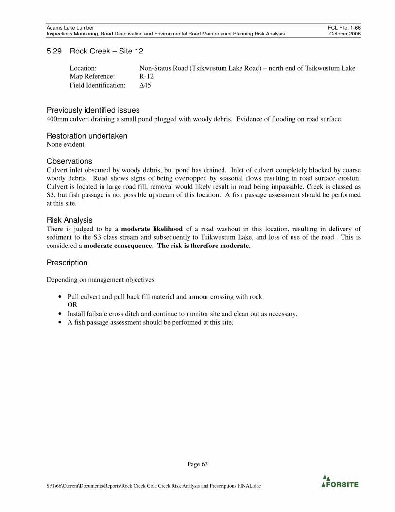
Adams Lake Lumber FCL File: 1-66 Inspections Monitoring, Road Deactivation and Environmental Road Maintenance Planning Risk Analysis October 2006
Page 63
S:\1\66\Current\Documents\Reports\Rock Creek Gold Creek Risk Analysis and Prescriptions FINAL.doc
5.29 Rock Creek – Site 12
Location: Non-Status Road (Tsikwustum Lake Road) – north end of Tsikwustum Lake
Map Reference: R-12
Field Identification: ∆45
Previously identified issues 400mm culvert draining a small pond plugged with woody debris. Evidence of flooding on road surface.
Restoration undertaken None evident
Observations Culvert inlet obscured by woody debris, but pond has drained. Inlet of culvert completely blocked by coarse
woody debris. Road shows signs of being overtopped by seasonal flows resulting in road surface erosion.
Culvert is located in large road fill, removal would likely result in road being impassable. Creek is classed as
S3, but fish passage is not possible upstream of this location. A fish passage assessment should be performed
at this site.
Risk Analysis There is judged to be a moderate likelihood of a road washout in this location, resulting in delivery of
sediment to the S3 class stream and subsequently to Tsikwustum Lake, and loss of use of the road. This is
considered a moderate consequence. The risk is therefore moderate.
Prescription
Depending on management objectives:
• Pull culvert and pull back fill material and armour crossing with rock
OR
• Install failsafe cross ditch and continue to monitor site and clean out as necessary.
• A fish passage assessment should be performed at this site.

Adams Lake Lumber FCL File: 1-66 Inspections Monitoring, Road Deactivation and Environmental Road Maintenance Planning Risk Analysis October 2006
Page 64
S:\1\66\Current\Documents\Reports\Rock Creek Gold Creek Risk Analysis and Prescriptions FINAL.doc
Photo 5.29.1 – ∆45 “Site 12” Ponding upstream of culvert.

Adams Lake Lumber FCL File: 1-66 Inspections Monitoring, Road Deactivation and Environmental Road Maintenance Planning Risk Analysis October 2006
Page 65
S:\1\66\Current\Documents\Reports\Rock Creek Gold Creek Risk Analysis and Prescriptions FINAL.doc
5.30 Rock Creek – Site 13
Location: Permitted Road (Tsikwustum Lake Road) – Near Branch “E” Junction
Map Reference: R-13
Field Identification: ∆48
Previously identified issues Surface erosion at a 600mm CMP possibly due to undersized culvert.
Restoration undertaken Replaced with 1000mm CMP
Observations 1000mm CMP on S4 class creek, functioning normally. Minor sediment production on cutslopes.
Risk Analysis There is judged to be a low to negligible likelihood of further sediment production at this site.
Prescription
• No further work required
Photo 5.30.1 – 1000mm CMP ∆48, “Site 12”

Adams Lake Lumber FCL File: 1-66 Inspections Monitoring, Road Deactivation and Environmental Road Maintenance Planning Risk Analysis October 2006
Page 66
S:\1\66\Current\Documents\Reports\Rock Creek Gold Creek Risk Analysis and Prescriptions FINAL.doc
5.31 Rock Creek – Site 14
Location: Tsikwustum Lake Road (North Rock Creek Road)
Map Reference: R-14
Previously identified issues Road fill erosion and slumping at 400mm CMP. Sediment source with a high potential to enter stream
network.
Restoration undertaken Culvert replaced, works completed as per Silvatech (2003) report.
Observations Culvert replaced with 800 mm CMP – functioning. No apparent issues since replacement. Connectivity to S2
immediately downstream.
Risk Analysis There is judged to be a low to negligible likelihood of further sediment production at this site.
Prescription
• No further work required

Adams Lake Lumber FCL File: 1-66 Inspections Monitoring, Road Deactivation and Environmental Road Maintenance Planning Risk Analysis October 2006
Page 67
S:\1\66\Current\Documents\Reports\Rock Creek Gold Creek Risk Analysis and Prescriptions FINAL.doc
5.32 Mosquito Creek (Site 1)
Location: Mosquito Creek
Map Reference: M-1
Field Identification: ∆54-∆67
Previously identified issues Stream diversions
Restoration undertaken Works as prescribed by Silvatech (2004) report completed by October 29, 2004.
Observations Works completed as described in Silvatech (2004) report were reviewed. This report recommended grass
seeding, which appears to have been completed to satisfaction. Cross drain structures and culverts have been
put in place. Flow appears to have been redirected back to the original stream locations satisfactorily. There is
some evidence of minor road surface runoff taking place – the road has been rutted by vehicle traffic, and
minor runoff is eroding the road surface. This road surface flow is intercepted by waterbars and cross ditches,
and is only a minor concern. The road is still accessible by truck; consider limiting vehicle access to ATVs
only.
Concerns on the upper rehabbed portion of road are generally with shallow cross drain structures which could
fail and divert drainage down the road, and lack of failsafe cross ditches at culvert locations, where a blockage
would send water down ditchlines, altering natural drainage patterns.
∆55-∆56 – a portion of the cross drained flow runs down the ditch and partly down the road surface. Although
it is intercepted by the cross ditch at station 56. At ∆58 – creek crossing – cross ditch is not sufficiently deep,
large flows could run down the road. The ditchline from ∆62 back is taking substantial flows. Base mapping
provided indicates that this flow comes from a stream which has been diverted along the ditch line, and had
been ditched across the new road at the switchback (∆66). There is an armoured cross ditch at ∆63, which puts
this stream back into what appears to be a the natural channel again. This stream then joins the S5 stream,
crossing the road at ∆67 in a 1200mm culvert. The 600mm culvert at ∆66 (previous diverted flow path) is now
experiencing only minimal flows. There is a failing box culvert at ∆69, which is only about 30% effective and
will soon fail.
Risk Analysis There is judged to be a moderate likelihood of ditch flows and cross drained flows running over or down the
road surface due to shallow / non-existent waterbars / failsafe cross ditching. This would result in road surface
erosion and drainage diversions on the access road and sediment delivery to S-6 and S5 classed streams. This
is considered a moderate consequence. The risk is therefore moderate.
Prescription
• ∆55-56 Install waterbars to remove road surface diversions
• ∆58 Deepen cross ditch.
• ∆61 Install failsafe cross ditch
• ∆67 Install broad shallow failsafe cross ditch – large flow potential, and overflow could run down

Adams Lake Lumber FCL File: 1-66 Inspections Monitoring, Road Deactivation and Environmental Road Maintenance Planning Risk Analysis October 2006
Page 68
S:\1\66\Current\Documents\Reports\Rock Creek Gold Creek Risk Analysis and Prescriptions FINAL.doc
road.
• ∆66-71 Significant sediment production in ditchline, seepage all along this ditch. Grass seed.
• ∆69 Replace failing box culvert with 800mm CMP.
• ∆70 600 CMP Install broad backup cross ditch.
• ∆71 500 CPP Install broad backup cross ditch.
Consider restricting the deactivated portion of the road to ATV traffic only to minimise sediment
production from rutting.
Note: The road back of ∆71 to the road junction is cut into poorly consolidated weathered schistose bedrock
and tills. Ditchlines are slumping and infilling. This road will require inspection and significant maintenance
measures (beyond the scope of this assessment)
Photo 5.32.1 – ∆59 Road surface drainage being intercepted by Cross Ditch, grass seeding effective.

Adams Lake Lumber FCL File: 1-66 Inspections Monitoring, Road Deactivation and Environmental Road Maintenance Planning Risk Analysis October 2006
Page 69
S:\1\66\Current\Documents\Reports\Rock Creek Gold Creek Risk Analysis and Prescriptions FINAL.doc
Photo 5.32.2 – ∆69, Failing wood culvert

Adams Lake Lumber FCL File: 1-66 Inspections Monitoring, Road Deactivation and Environmental Road Maintenance Planning Risk Analysis October 2006
Page 70
S:\1\66\Current\Documents\Reports\Rock Creek Gold Creek Risk Analysis and Prescriptions FINAL.doc
Figure 7 – Mosquito Creek Site 1 Detail

Adams Lake Lumber FCL File: 1-66 Inspections Monitoring, Road Deactivation and Environmental Road Maintenance Planning Risk Analysis October 2006
Page 71
S:\1\66\Current\Documents\Reports\Rock Creek Gold Creek Risk Analysis and Prescriptions FINAL.doc
5.33 Honeymoon Bay (Site 2)
Location: Honeymoon Bay recreation site.
Map Reference: H-2
Previously identified issues Grass seeding may be required in areas of previous restoration works.
Restoration undertaken • Ditch line cleanout
• Half-waterbars allowing trailer access to rec. site.
• Construction of rock weirs in ditching and settlement ponds at the lower end adjacent to the lake
• Minor grading of road surface
• CMP cleanout, armour ditch in areas of past erosion / concentrated flows
Observations
Works as described in Silvatech (2004) report have been completed. Ditchline clean and functioning, some
grass and shrub vegetation establishing naturally. Road cut materials exposed and some ravelling into ditchline
taking place.
Shallow waterbars are located on the upper portion of the road, and are effectively draining road surface runoff
into the ditchline. These are starting to wear / infill due to traffic with some washboarding taking place.
The sumps for the two 300 mm pipes appear to have been very recently cleaned out (Spring 2006?) The
material removed has been piled directly adjacent to the sumps and is slumping back in. Drainage laden with
fine sediment is discharging into the lake directly below (See photos 5.33.1a-5.33.1c). Culverts are undersized
and have a high likelihood of becoming plugged.
Risk Analysis There is judged to be a high likelihood of continuous delivery of a small amount of fine sediment via the
ditchline and inadequate sumps at the culvert inlets to Adams Lake. This is considered a low consequence.
The risk is therefore moderate.
Prescription
• Remove slumping material adjacent to culvert sumps, establish broad shallow armoured sumps and
grass seed.
• Grass seed ditchline and cut slopes as prescribed in Silvatech (2004).
• Monitor and maintain waterbars on upper portion of access road.

Adams Lake Lumber FCL File: 1-66 Inspections Monitoring, Road Deactivation and Environmental Road Maintenance Planning Risk Analysis October 2006
Page 72
S:\1\66\Current\Documents\Reports\Rock Creek Gold Creek Risk Analysis and Prescriptions FINAL.doc
Photo 5.33.1a– Honeymoon Bay – 300mm pipe at end of ditch above lake.
Photo 5.33.1b – Honeymoon Bay. Sump at end of road, appears recently cleaned out.

Adams Lake Lumber FCL File: 1-66 Inspections Monitoring, Road Deactivation and Environmental Road Maintenance Planning Risk Analysis October 2006
Page 73
S:\1\66\Current\Documents\Reports\Rock Creek Gold Creek Risk Analysis and Prescriptions FINAL.doc
Photo 5.33.1c – Honeymoon Bay. Culvert discharge directly into lake.
Photo 5..33.2 – ∆76 – Berm deflecting creek drainage down ditchline.

Adams Lake Lumber FCL File: 1-66 Inspections Monitoring, Road Deactivation and Environmental Road Maintenance Planning Risk Analysis October 2006
Page 74
S:\1\66\Current\Documents\Reports\Rock Creek Gold Creek Risk Analysis and Prescriptions FINAL.doc
Photo 5.33.3– Improved ditchline on Honeymoon Bay recreation site road.

Adams Lake Lumber FCL File: 1-66 Inspections Monitoring, Road Deactivation and Environmental Road Maintenance Planning Risk Analysis October 2006
Page 75
S:\1\66\Current\Documents\Reports\Rock Creek Gold Creek Risk Analysis and Prescriptions FINAL.doc
5.34 Momich Lake Site 3
Location: South of Momich Lake
Map Reference: M-3
Previously identified issues Old log box culvert – holes have developed in the road, with water passing beneath the road. Road has
existing deactivation.(Silvatech 2004)
Restoration undertaken This site is located near the end of a road which has been deactivated (primarily cross ditched) and is
revegetating.
Observations
The road has been deactivated with frequent cross ditches and is revegetating with alder and immature
coniferous species. The site in question is an old log box culvert which is conveying water under the road
surface. Holes have formed in several places. Immediately downslope of this site, the outlet of this cross
drainage is armoured with very large boulders (>1.5m diameter). The site is in a broad shallow draw. Slopes
below are planar at about 40-45%. There is a failsafe cross ditch in place. The road prism is unlikely to fail
catastrophically, and blockage of the current flow would be conveyed across the road surface in the failsafe
back into the natural channel.
Risk Analysis Because of the existence of a backup cross ditch and heavy armouring of the outlet, There is judged to be a low
to negligible likelihood that this failing log box will significantly in a slope failure.
Prescription
Removal of this structure will not result in a significant reduction in risk, and bringing equipment up this
already deactivated road is likely to result in excessive disturbance.
• No further work required

Adams Lake Lumber FCL File: 1-66 Inspections Monitoring, Road Deactivation and Environmental Road Maintenance Planning Risk Analysis October 2006
Page 76
S:\1\66\Current\Documents\Reports\Rock Creek Gold Creek Risk Analysis and Prescriptions FINAL.doc
Photo 5.34.1 – Site 3 Momich Lake area.

Adams Lake Lumber FCL File: 1-66 Inspections Monitoring, Road Deactivation and Environmental Road Maintenance Planning Risk Analysis October 2006
Page 77
S:\1\66\Current\Documents\Reports\Rock Creek Gold Creek Risk Analysis and Prescriptions FINAL.doc
5.35 Momich Lake Site 5
Location: South of Gannet Lake
Map Reference: M-5
Field Identification: ∆5
Previously identified issues Ravelling has blocked a culvert.
Restoration undertaken None
Observations Culvert inlet almost entirely blocked by boulders but still partially functioning. Cross drain culvert taking
about 5% of the flow. Significant stream upslope could lead to large washout if not repaired.
Risk Analysis There is judged to be a high likelihood of the culvert completely failing and causing a washout resulting in
sediment delivery to the S5 stream downslope, with a moderate likelihood of sediment delivery to the S3 reach
of the same stream. This is considered a moderate consequence. The risk is therefore high.
Prescription
• Clean out or replace culvert
OR
• Pull culvert and re-establish natural stream course.
Photo 5.35.1 – Site 5 Gannet Lake area.

Adams Lake Lumber FCL File: 1-66 Inspections Monitoring, Road Deactivation and Environmental Road Maintenance Planning Risk Analysis October 2006
Page 78
S:\1\66\Current\Documents\Reports\Rock Creek Gold Creek Risk Analysis and Prescriptions FINAL.doc
6.0 Closure
This assessment focussed primarily on previously identified sites, but observations of general watershed
condition and sediment sources and other potential problem areas were noted.
Several natural sediment producing sites were noted during the Gold Creek helicopter overflight, but no
additional areas with significant issues related to forest harvesting or road construction, other than those
identified in this report, were observed.
This risk analysis has been carried out in accordance with generally accepted engineering and geoscientific
practice for the area. Conclusions and recommendations presented herein are based on air photo interpretation
and visual site inspections of selected areas in each watershed. Further, assessments of soils and slope stability
are based on interpretation of surface features and limited sub-surface investigation; actual ground conditions
may vary from those inferred.
This report provides a qualitative evaluation of hazards associated with sites previously identified in the study
area, a description of the potential consequences, and recommendations to reduce the hazards and associated
risks. Acceptance of the qualitative consequence values and the subsequent risk analysis is the responsibility
of the licensee or the regulatory authority, as is the determination of acceptable risk and the decision to proceed
with any action based on that risk analysis.
We trust that this report satisfies your present requirements. Should you have any questions or comments,
please contact our office at your convenience.
Sincerely,
Forsite Consultants Ltd.
Prepared by: Reviewed By:
Peter Weisinger, M.Sc. G.I.T. Rod Williams, P.Geo
Project Geoscientist Project Geoscientist