road infrastructure requirements for connected and
TRANSCRIPT


Road Infrastructure Requirements for Connected and Automated VehiclesSLAIN Activity 7 results
Presented by: Leonid Ljubotina, FPZ

SLAIN objectives
Review of some relevant factors associated with the preparation of the readiness of Europe’s physical infrastructure for automation.
Proposals for section-specific, economically viable crash countermeasuresdesigned to raise infrastructure quality and achieve significant reductions insevere injuries and deaths.
The assessment of the Safety Performance Management of the TEN-T core road network in four European countries: Spain, Italy, Croatia and Greece.
The demonstration of a methodology of network-wide road assessment.
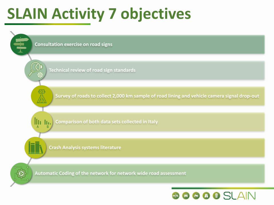
SLAIN Activity 7 objectives
Consultation exercise on road signs
Technical review of road sign standards
Survey of roads to collect 2,000 km sample of road lining and vehicle camera signal drop-out
Comparison of both data sets collected in Italy
Crash Analysis systems literature
Automatic Coding of the network for network wide road assessment

SLAIN methodology
D7
.2 M
eth
od
olo
gy
State of the Art
Review of Automated Driving Systems
Review of CAV crash patterns
Review of iRAP road attributes

Review of Automated Driving Systems
The first part of the report focuses on the state-of-the-art summary review of automated driving systems (ADS) capabilities and future requirements and challenges for the physical road infrastructure.
Sensor coverage needs can vary depending on the level of driving task, driving speed, road type, road environment, daylight and other environmental factors.
Sensor fusion multicolor processing should be further enhanced, rather than grayscale or binary images, to improve the detection algorithms.
A public benchmarking dataset should be created to assess the performance of algorithms including thresholding.
The digital representation of the physical infrastructure will need high-quality standard both in accuracy (GPS, GNSS) and timeliness of the data updates.
Although technology is continuously improving by CAV developers, the automated driving system / dynamic driving tasks still need to be further developed to bridge the gap between research and deployment.

Review of CAV crash patterns
Based upon earlier versions of the “Roads that Cars Can Read’’ series.
The greatest challenge is to predict the changes in characteristics and types of crashes that will occur in the future.
Novel crash risk factors for CAVs (environmental road surface and weather condition, vehicle technical deficiency, inappropriate load, database deficiency, new situation, system failure, cyber-attack).
VRUs and CAV crashes will require adjustments to the parameters that constitute the definitions of Safe Distance and Proper Response.
There is still a lot of research to be done in relation to physical road attributes and ADS crash types/rates/patterns.
Future research is needed to the effectiveness of individual countermeasures (e.g., rumble strips, striping, adjustments to lane widths) with the increase in CAV penetration rate.

Road Infrastructure Requirements for CAVs
Scientific literature of the relationship between CAV vehicles and 22 physical infrastructure attributes (based upon IRAP Star Rating model) was rewiewed.
Delineation (Road Markings - Skid Resistance, Traffic Signs Shoulder and Centreline Rumble Strips)
Roadway (Carriageway and number of lanes, lane width, median, paved shoulder width, road condition)
Road Environment (curvature, grade, Street Lighting, Tunnels)
Roadside severity
Vulnerable Road Users (facilities for bicycles, facilities for motorcycles, pedestrian crossing facilities, school zone warning, vehicle parking)
Intersections (Intersection and Traffic Lights)
Speed
Intelligent Transport Systems (ITS)/Roadworks
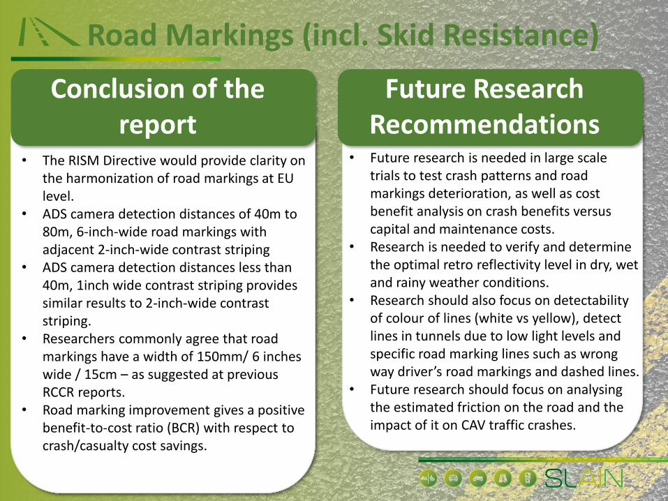
Road Markings (incl. Skid Resistance)
Conclusion of thereport
Future Research Recommendations
• The RISM Directive would provide clarity on the harmonization of road markings at EU level.
• ADS camera detection distances of 40m to 80m, 6-inch-wide road markings with adjacent 2-inch-wide contrast striping
• ADS camera detection distances less than 40m, 1inch wide contrast striping provides similar results to 2-inch-wide contrast striping.
• Researchers commonly agree that road markings have a width of 150mm/ 6 inches wide / 15cm – as suggested at previous RCCR reports.
• Road marking improvement gives a positive benefit-to-cost ratio (BCR) with respect to crash/casualty cost savings.
• Future research is needed in large scale trials to test crash patterns and road markings deterioration, as well as cost benefit analysis on crash benefits versus capital and maintenance costs.
• Research is needed to verify and determine the optimal retro reflectivity level in dry, wet and rainy weather conditions.
• Research should also focus on detectability of colour of lines (white vs yellow), detect lines in tunnels due to low light levels and specific road marking lines such as wrong way driver’s road markings and dashed lines.
• Future research should focus on analysing the estimated friction on the road and the impact of it on CAV traffic crashes.

Traffic SignsConclusion of the
reportFuture Research
Recommendations• Traffic sign recognition systems common
errors are in quality, status, quantity,visibility, perception, recognizability,clarity, and interpretability of the boardsat the permitted speed.
• The RISM Directive would provide clarityon the harmonization of traffic signs atEU level. This needs to be accompaniedwith regulatory (UNECE) andstandardisation activities (CEN).
• Comprehensive and systematic trafficsigns asset inventory system is essentialand linked with survey of road condition(or survey/monitoring of otherinfrastructure assets).
• Future research should focus on CAV readability of sign types, symbols used, shapes, heights, locations, influenced by weather, environmental conditions, visibility, and noticeability.
• Methodology for the classification of horizontal and vertical traffic sign anomalies that may help in designing better testing and validation environments for traffic sign recognition systems in the future.
• Future research is needed on AI algorithms for CAV readability training using labelled examples.
• Research is needed to examine crash patterns and CAV readability of signs as well as cost benefit analysis for maintenance.
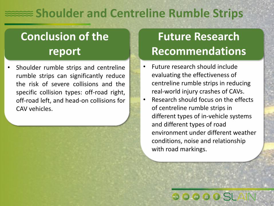
Shoulder and Centreline Rumble Strips
Conclusion of thereport
Future Research Recommendations
• Shoulder rumble strips and centrelinerumble strips can significantly reducethe risk of severe collisions and thespecific collision types: off-road right,off-road left, and head-on collisions forCAV vehicles.
• Future research should include evaluating the effectiveness of centreline rumble strips in reducing real-world injury crashes of CAVs.
• Research should focus on the effects of centreline rumble strips in different types of in-vehicle systems and different types of road environment under different weather conditions, noise and relationship with road markings.

Carriageway and the number of lanes
Conclusion of thereport
Future Research Recommendations
• CAV dedicated lanes has significant advantages in relation to safety at merging and diverging sections of highways (e.g., truck platoons).
• CAV with equipped Lane-Keeping-System (LKS) would also negatively impact on the deterioration of the road condition, especially in dedicated lanes.
• Electronic Stability Control will function better on divided highways and importantly this should lead to a considerable reduction in the occurrence of injury crashes.
• Motorways with dedicated high-speed lanes for CAVs, reserved exit ramps should be considered.
• Future research needs to investigate the effects of traffic safety on carriageway, road capacity, dedicated lanes or segregated lanes and safe harbour areas while considering ADS systems for vehicles and trucks.

Lane width and paved shoulder width
Conclusion of thereport
Future Research Recommendations
• Future research should focus on the study of the impact of lane and paved shoulder width on CAV performance.
• Research concludes that in the future the width of the lane could be reduced, as LKS will guarantee that the vehicle will maintain an optimal central position.
• A recommendation of a lane width of 2.72 m was found to have the same optimal probability of automatic and human lateral control, this therefore being the ‘critical’ lane width for safe operation.
• In addition, CAVs equipped with Lane Departure Warning (LDW) and Lane Keeping Aid (LKA) systems are highly dependent on roadway characteristics, such as lane markings (presence/clarity) and also lane and shoulder width.

Median and side guard railsConclusion of the
reportFuture Research
Recommendations
• Where the road is undivided, rumble strips or in-vehicle lane support systems such as LDW, LKA and Emergency Lane Keeping (ELK), have the potential to play an important role to reduce unintentional lane drifting and reduce crashes.
• Future research should focus on the impact of medians on CAV performance.

Road ConditionConclusion of the
reportFuture Research
Recommendations
• The research recommends proactive more frequent monitoring of the road condition via new technologies.
• Future research should focus on the relationship of road condition and CAV crash patterns as well as investigating new technologies for proactive monitoring of the road condition.
• This includes wet or icy surfaces that influence the visibility of features such as road gradient, curvature, and lane widths, condition of road markings and traffic signs.
• New research shows that the early detection of pavement distress has a positive relationship with the reduction of fatal traffic casualties.
• Correlation between road condition in CAV dedicated lanes and safe operation; greater wearing in these lanes will accelerate the appearance of rutting and other pavement deteriorations.

Road Grade Conclusion of the
reportFuture Research
Recommendations• New research on the grade of the road
and the actual trajectory tracking performance, roll stability and pitch stability performance of ADS has been analysed.
• The road design information, such as bank angle and road slope, can significantly affect the trajectory tracking performance of the CAV, so this information needs to be considered in the trajectory planning and tracking control for off-road CAV.
• Research is not available on CAV crash patterns and grade of the road.
• Future research should focus on the grade of the road and actual trajectory tracking performance, roll stability and pitch stability performance of ADS.

Road Curvature Conclusion of the
reportFuture Research
Recommendations• Future research is needed to further
explore how CAV steering functions takes the curvature pattern into account particularly at higher speeds and cornering situations to improve traffic safety.
• Road curvature plays an important role for CAV operation especially regarding the type of curve (e.g., circular-arc segments), and the interaction of speed, lateral position and the vehicle’s safe cornering performance. Early research gives positive indications that curvature can be accurately read by machine vision systems. Research is not available that addresses CAV crash patterns in relation to road curvature.

Street LightingConclusion of the
reportFuture Research
Recommendations• Driving CAVs in poor lighting is associated
with road traffic injuries in autonomous mode versus in conventional mode, probably resulting in higher odds of injuries.
• Ensuring that the visibility of road markings, signals and signs is suitable for CAVs to perform effectively may require improved street lighting, either through better illumination or more closely spaced lights.
• The research concluded that future research would be needed on light-based assistance systems that will be able to use the high potential of LED-arrays to create a highly variable light distribution.
• Future research on the correlation of crashes and street lighting during day and night-time involving vulnerable road users is required.
• Future research on light-based assistance systems to optimise CAV-related road safety in poor lighting conditions is required.
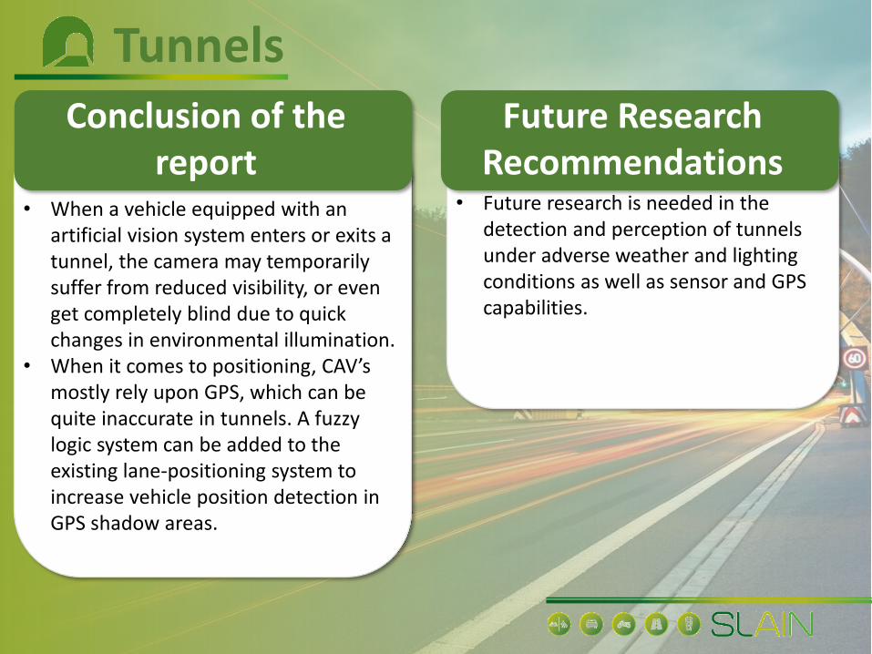
TunnelsConclusion of the
reportFuture Research
Recommendations• When a vehicle equipped with an
artificial vision system enters or exits a tunnel, the camera may temporarily suffer from reduced visibility, or even get completely blind due to quick changes in environmental illumination.
• When it comes to positioning, CAV’s mostly rely upon GPS, which can be quite inaccurate in tunnels. A fuzzy logic system can be added to the existing lane‐positioning system to increase vehicle position detection in GPS shadow areas.
• Future research is needed in the detection and perception of tunnels under adverse weather and lighting conditions as well as sensor and GPS capabilities.

Roadside Object and Distance Conclusion of the
reportFuture Research
Recommendations• Object detection is still regarded as a
challenge for CAVs, especially for moving objects such as bicycles and pedestrians; determining the reasonable safety clear zone for objects is also difficult.
• There is no related crash research available with object recognition issues.
• Accuracy of the object recognition process (can be solved via prior knowledge of the traffic infrastructure on the planned route (ie. High-Definition map).
• Issues have also been encountered with AI algorithms and related image processing.
• More research is required in evaluating the effectiveness of the roadside object and distance detection in reducing real-world injury crashes of CAVs via HD maps.
• Further research is needed to work on AI algorithms and image processing.

IntersectionsConclusion of the
reportFuture Research
Recommendations• Divergent views on the attribute
(relevance of roundabouts) • The road attribute for intersection is
highly relevant for CAVs as early studies show a reduction in crash rates.
• According to findings, the signalised intersection, CAVs reduce the number of conflicts by 20% to 65% with the CAV penetration rates of between 50% and 100%. For the roundabout, the number of conflicts is reduced by 29% to 64% with the 100% CAV penetration rate.
• C-ITS has found to tackle intersections in several pilot projects.
• Future research is needed in the sensing and perception of intersections, roundabouts, and the impact on crashes.
• Future research should focus on the potential difference in crash patterns at different fleet penetration rates of CAVs with various network design formats (e.g., Junction types, slip roads/weaving lanes grade separated junctions and controlled junctions, U turn opportunities, gaps in median and traffic conditions).
Traffic LightsConclusion of the
reportFuture Research
Recommendations• Several studies showed evidence of locating
and/or recognizing all traffic lights in a scene but found issues in understanding the context of the sign (green, yellow, red) due to the dynamic nature of the traffic light.
• Other challenges included early recognition (detecting traffic lights at greater distances), and recognition in different illumination settings (including night images).
• Another interesting research paper focused on integrating recognition with prior HD maps which record position, direction.
• Ensuring the vehicle is also connected through C-ITS such as green light optimal speed advisory (GLOSA) can provide additional reassurance for speed advice to drivers.
• Further research is required in understanding CAV crash patterns with and without traffic lights.
• Future research is required on traffic light recognition in adverse conditions (e.g., rain, snow), early recognition (detecting traffic lights at greater distances), and recognition in different illumination settings (including night images).
• A further recommendation would focus on understanding CAV crash patterns with and without traffic lights.
Bicycles and FacilitiesConclusion of the
reportFuture Research
Recommendations• Research shows that CAVs could
ultimately bring about changes to the road design by opening more space for bicycle lanes or for the building of segregated bicycle tracks, depending on the operating environment.
• Simulations with CAVs indicate a potentially notable reduction in the total number of conflicts that may occur between cars and bicyclists compared with the current situation; this needs further research and large-scale field trials.
• Future research is needed to study the safe interaction between bicyclists, pedestrians, and CAVs during different weather conditions.
• Further research is also needed on object recognition due to the unpredictable bicyclist user behaviour and due to size of the bicycle.

Powered two wheelers and facilities
Conclusion of thereport
Future Research Recommendations
• Research to date states that CAV sensors and algorithms are not capable to detect and identify PTWs.
• Future research is needed on the potential for the occurrence of crashes between CAV and powered two-wheelers in traffic flows as well as CAV sensors and algorithms to detect and identify PTWs.

Pedestrians and pedestrian crossings
Conclusion of thereport
Future Research Recommendations
• The presence of pedestrian crossings and facilities are highly relevant for CAV safe operation.
• Real-time object recognition studies have so far indicated satisfactory results for the detection of pedestrians using crossings. it is important that sensor systems can detect pedestrian crossings (empty crossing versus one with a pedestrian) to reduce the risk of a collision.
• Future research should focus on sensing and detection capabilities for pedestrian crossing facilities to reduce the risk of fatal collisions in urban and regional areas.

School zone warning Conclusion of the
reportFuture Research
Recommendations• The school zone warning is another
important road attribute which needs to be detected by CAVs.
• A CAV entering a school zone is subjected to lower speed limits and must respond appropriately to ensure the safety of its passengers and other road users. Geofencing was regarded as an important countermeasure.
• Service providers can relate to these zones and apply virtual delays on top, so that the routing algorithm proposes an alternative way, more in line with the public's authority expectations.
• It is recommended that future research on sensing and identification of school zone warnings (e.g., traffic signs, speed limits) as well as school zone warning supervisor (people helping kids cross the road) is undertaken. as well the impact on school zone on CAV crashes.
Vehicle ParkingConclusion of the
reportFuture Research
Recommendations• The presence of parking and the action
of parking is a hazard to other road users and can be an obstruction to signs and road markings.
• An analysis of the use case Highway Chauffeur (HC) System (Agriesti, 2019) found 21 collisions occurred against a regularly stopped vehicle. These crashes were considered addressable by the L3 system and potentially preventable.
• Future research would be needed in the detection and perception systems of parking as an obstacle to sight distance and parking slot recognition method under a variety of lighting conditions.

SpeedConclusion of the
reportFuture Research
Recommendations• Speed is one of the most crucial road
attributes for CAVs, especially as Intelligent Speed Assistance (ISA) will be included in all new vehicles as part of the EU General Safety Regulation (GSR) Directive, to help drivers to keep within the speed limit.
• Initial research showed that ADS can adapt the speed of the vehicle based on the road design characteristics.
• It is recommended that research is undertaken into the effects of different speed profiles in different types of CAV use cases on roads with different operating environments.
• Future research is needed on the correlation between crash patterns and the speed of the CAV vehicle.
• Future research is needed on the correlation between road design characteristics and the speed of the CAV vehicle.

C-ITS (e.g., RoadWorks)Conclusion of the
reportFuture Research
Recommendations• The use of a range of C(ITS) solutions (e.g.,
ramp metering, incident detection, weather monitoring, VMS / advance warning, lane keeping, hard-shoulder running, variable speed limits and managed motorways) are helping to reduce crash rates on motorways.
• Road works was used as example. • Incidents and roadworks will change the
road layout, which require CAVs to interpret real-time changes, such as merging-lanes suggestions provided by temporary signs and cones.
• iRAP is currently also working on an extensive list of road attributes for ITS technologies under its innovation framework.
• Future research is needed in analysing the impact of ITS roadside measures in the sensing, perception, and mapping/positioning of CAVs.

Automatic Coding
A preliminary feasibility study of automatic recognition of road safety attributes according to the iRAP methodology.
Process initially relied on monocular video as the only input modality, but can be extended to process rasterized 2D projections of point-cloud input data, if such data is available.
Problem was formulated as a separate multi-class classification of each iRAP attribute in georeferenced video clips that correspond to particular road segments.
A solution is based on an efficient multi-task model with shared features, which can recognize all attributes with a single forward pass and learn in an end-to-end fashion.

The recognition success wildly varies across the attributes.
Study addressed a subset of 33 iRAP attributes.
Study shows that the described setup suffers from many problems that are not present in academic datasets, the most important among them being the extreme class imbalance that a lot of attributes suffer from.
Automatic Coding

Some attributes such as Delineation or Divided carriageway are ready for full automation.
On some other attributes, model is not yet ready for industrial exploitation, either because of too few training data or because of the sheer difficulty of the recognition problem.
Automatic Coding
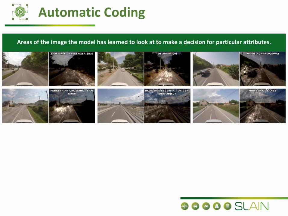
Areas of the image the model has learned to look at to make a decision for particular attributes.
Automatic Coding

Automatic Coding - 10toGo Challenge
Microsoft is organizing the 10toGo Challenge to facilitate achieving Sustainable Development Goals.
The Faculty of Transport and Traffic Sciences at the University of Zagreb [and other SLAIN partners] have partnered with Microsoft on the challenge to organize a task to address automatic coding of iRAP road safety attributes.
A rich, fully-annotated dataset, consisting of 570 km of the Croatian motorway A1 was provided by the faculty. Such a dataset is crucial for the development of a data-driven AI solution.
The company Nagarro applied to the challenge with a small team of engineers with expertise in this area and, provided they succeed to enter the challenge, they will work on the task for 6 months.
Their solutions and innovations during that time will be immensely beneficial for long-term goals of achieving global road safety.
➢More than 160 references/bibliographies collected and assessed.
➢ FP7-H2020 European Commission projects from 2008 till 2017 focus only on digital infrastructure and CAVs research.
➢ Road markings, traffic signs and pilot results as analysed in SLAIN D7.1 are not the sole physical infrastructure requirements for CAVs. All iRAP Road Attributes are relevant for Automated Driving Systems (ADS) dynamic driving tasks.
➢ There is no clear published (or otherwise available) knowledge at this point regarding the changes required in physical infrastructure to scale up the changes required to make CAV operation possible.
➢ Exchange of best practices with other projects such as the CEDR MANTRA, CEDR DIRIZONand H2020 INFRAMIX projects, and platforms such as the European ITS Platform (EUEIP), TN-ITS and the CEF SLAIN project would promote the development of common andcomplementary recommendations.
➢ The report will also support European Commission CCAM Platform WG3 on Physical andDigital Infrastructure to shape its future research priorities for the next Work programmeof Horizon Europe and CEF programme.
Generic Conclusions

Thank you for your attention!