rnav arrival reports - asrs.arc.nasa.gov · rnav arrival reports . ... a c-206 pilot received a low...
TRANSCRIPT

ASRS Database Report Set
RNAV Arrival Reports
Report Set Description .........................................A sampling of reports that reference RNAV Arrival related incidents.
Update Number ....................................................9.0
Date of Update .....................................................January 31, 2017
Number of Records in Report Set ........................50
Number of New Records in Report Set ...............50
Type of Records in Report Set .............................For each update, new records received at ASRS will displace a like number of the oldest records in the Report Set, with the objective of providing the fifty most recent relevant ASRS Database records. Records within this Report Set have been screened to assure their relevance to the topic.

National Aeronautics and Space Administration
Ames Research Center Moffett Field, CA 94035-1000
TH: 262-7
MEMORANDUM FOR: Recipients of Aviation Safety Reporting System Data
SUBJECT: Data Derived from ASRS Reports
The attached material is furnished pursuant to a request for data from the NASA Aviation Safety Reporting System (ASRS). Recipients of this material are reminded when evaluating these data of the following points.
ASRS reports are submitted voluntarily. The existence in the ASRS database of reports concerning a specific topic cannot, therefore, be used to infer the prevalence of that problem within the National Airspace System.
Information contained in reports submitted to ASRS may be amplified by further contact with the individual who submitted them, but the information provided by the reporter is not investigated further. Such information represents the perspective of the specific individual who is describing their experience and perception of a safety related event.
After preliminary processing, all ASRS reports are de-identified and the identity of the individual who submitted the report is permanently eliminated. All ASRS report processing systems are designed to protect identifying information submitted by reporters; including names, company affiliations, and specific times of incident occurrence. After a report has been de-identified, any verification of information submitted to ASRS would be limited.
The National Aeronautics and Space Administration and its ASRS current contractor, Booz Allen Hamilton, specifically disclaim any responsibility for any interpretation which may be made by others of any material or data furnished by NASA in response to queries of the ASRS database and related materials.
Linda J. Connell, Director NASA Aviation Safety Reporting System

CAVEAT REGARDING USE OF ASRS DATA
Certain caveats apply to the use of ASRS data. All ASRS reports are voluntarily submitted, and thus cannot be considered a measured random sample of the full population of like events. For example, we receive several thousand altitude deviation reports each year. This number may comprise over half of all the altitude deviations that occur, or it may be just a small fraction of total occurrences.
Moreover, not all pilots, controllers, mechanics, flight attendants, dispatchers or other participants in the aviation system are equally aware of the ASRS or may be equally willing to report. Thus, the data can reflect reporting biases. These biases, which are not fully known or measurable, may influence ASRS information. A safety problem such as near midair collisions (NMACs) may appear to be more highly concentrated in area “A” than area “B” simply because the airmen who operate in area “A” are more aware of the ASRS program and more inclined to report should an NMAC occur. Any type of subjective, voluntary reporting will have these limitations related to quantitative statistical analysis.
One thing that can be known from ASRS data is that the number of reports received concerning specific event types represents the lower measure of the true number of such events that are occurring. For example, if ASRS receives 881 reports of track deviations in 2010 (this number is purely hypothetical), then it can be known with some certainty that at least 881 such events have occurred in 2010. With these statistical limitations in mind, we believe that the real power of ASRS data is the qualitative information contained in report narratives. The pilots, controllers, and others who report tell us about aviation safety incidents and situations in detail – explaining what happened, and more importantly, why it happened. Using report narratives effectively requires an extra measure of study, but the knowledge derived is well worth the added effort.

Report Synopses

ACN: 1403939 (1 of 50)
Synopsis An air carrier First Officer reported confusion when flying the MSO RNAV-D approach after ATC cleared the flight UBIJO direct BOTBY. Because the STACC waypoint was deleted, the flight descended to 10,300 ft which is below the STACC 11,300 ft MEA.
ACN: 1403923 (2 of 50)
Synopsis B737NG flight crew reported the BNA CHSNE 2 RNAV Arrival design keeps aircraft high on the arrival making the crossing restriction at BGSTR difficult.
ACN: 1402009 (3 of 50)
Synopsis Flight Crew and Controller reported of the flight being off course and entering Restricted Area P-56. Controller reported of aircraft being below the Minimum Vectoring Altitude and needing to vector aircraft out of P56. Pilot reported of improperly identifying the Potomac River and the aircraft to follow.
ACN: 1401998 (4 of 50)
Synopsis Air carrier flight crew reported responding to a TCAS RA on arrival into OAK airport. Controller workload with VFR aircraft was contributing.
ACN: 1401551 (5 of 50)
Synopsis A CRJ900 First Officer reported the Captain set the level off altitude below 1,000 feet AGL while descending for a night visual. The First Officer finally asked the Captain his intention at which time the EGPWS "TERRAIN" alerted. The descent was arrested without the escape maneuver. The First Officer questioned the Pilot Handbook escape maneuver wording.
ACN: 1400801 (6 of 50)
Synopsis A C-206 Pilot received a low altitude alert from ATC while flying a RNAV GPS and concentrating too intently on his new Garman 750.
ACN: 1399158 (7 of 50)
Synopsis BNA TRACON Controller reported an unsafe situation related to the Fusion radar and the use of RNAV procedures.

ACN: 1398528 (8 of 50)
Synopsis CE550 Captain reported being issued holding instructions during arrival to HWD via a modified WNDSR2 STAR, on a VMC day with light traffic. After two turns in the holding pattern and stating low fuel, he is vectored out over the Livermore valley and turned in behind a practice approach to HWD.
ACN: 1398306 (9 of 50)
Synopsis MD-11 Captain reported difficulty complying with multiple short-notice clearance changes on arrival into PHX.
ACN: 1397559 (10 of 50)
Synopsis B737 flight crew and three flight attendants reported a hard landing that caused the flight attendants to seek medical attention. The flying First Officer was receiving IOE training.
ACN: 1396613 (11 of 50)
Synopsis Air Carrier First Officer reported that when flying the ILS RWY 1R circle to land runway 30 at IAD following the glideslope sets one up for an unstabilized approach and questions why there is not an RNAV or FMS visual to runway 30.
ACN: 1395538 (12 of 50)
Synopsis B737 NG Captain reported receiving multiple confusing clearance changes on arrival into MMMX that greatly increased workload.
ACN: 1394412 (13 of 50)
Synopsis Air carrier Captain reported observing another aircraft that appeared to have landed in close proximity on a crossing runway at EWR airport.
ACN: 1393844 (14 of 50)
Synopsis B737 Captain reported difficulty getting cooperation with ATC concerning which STAR transition to fly.
ACN: 1393738 (15 of 50)

Synopsis A320 flight crew reported they did not set altimeters correctly and ended up high on the first approach which necessitated a go-around.
ACN: 1393562 (16 of 50)
Synopsis Air carrier flight crew set up for the wrong direction SLC airport STAR. Flight crew communication was cited as a contributing factor.
ACN: 1393533 (17 of 50)
Synopsis B737-800 flight crew could not make out displaced threshold markings on landing runway. Aircraft struck marker cones short of the threshold upon touchdown.
ACN: 1393005 (18 of 50)
Synopsis PCT Tracon Controller reported a loss of separation between an IFR and VFR aircraft. He recommended modification to the Bravo airspace.
ACN: 1392904 (19 of 50)
Synopsis Flight crew reported that while on a night arrival to LFPG they were issued a new arrival by ATC. They had difficulty finding the new arrival because, recently Jeppesen Charting expanded the category APPROACH to include RNAV ARRIVALS and RNAV NIGHT ARRIVALS which are not approaches. Reportedly the RNAV, NIGHT NAV distinction appears arbitrary and confusing.
ACN: 1392216 (20 of 50)
Synopsis PA28 pilot on an IFR flight plan in VMC at 4,000 feet reported a NMAC with another aircraft climbing out. An onboard traffic avoidance system and ATC advised the reporter of the traffic conflict.
ACN: 1391454 (21 of 50)
Synopsis An air carrier flight crew described a late descend clearance which placed the aircraft approximately 4,000 feet high on the ZHU MSCOT RNAV STAR. ATC then vectored the aircraft about 35 miles which the crew objected to. ATC stated the vector put the aircraft in proper spacing for further descent.
ACN: 1390000 (22 of 50)
Synopsis Air Carrier Captain reported that during construction a FWA, with Runways 14/32 closed and the first 1681 feet of Runway 23 closed, the RNAV (GPS) may not be suitable for some operators due to the requirement for a continuous descent approach and the displaced threshold.
ACN: 1389941 (23 of 50)
Synopsis Regional Jet flight crew reported declaring minimum fuel after abandoning an approach to MSY due to a microburst alert and successfully landed on the second attempt.
ACN: 1389737 (24 of 50)
Synopsis Air carrier Captain reported using an out of service approach into BOI which resulted in an EGPWS "CAUTION TERRAIN" alert.
ACN: 1389034 (25 of 50)
Synopsis A Local Controller reported not noticing a student pilot line up to land on the wrong parallel runway. The aircraft cut in front of a corporate jet aircraft on short final who initiated a go around on their own.
ACN: 1388732 (26 of 50)
Synopsis B90L Pilot reported receiving a terrain warning and a climb clearance from ATC after he misunderstood his clearance and descended early.
ACN: 1388029 (27 of 50)
Synopsis B737-800 Captain reported the FMC workload on DEN arrivals is often excessively high, and complicated by multiple runway changes and procedure irregularities.
ACN: 1388005 (28 of 50)
Synopsis CE-680 Captain reported a track deviation resulted from either a miscoded arrival or the aircraft's "smart turn" characteristics.
ACN: 1387698 (29 of 50)
Synopsis

Corporate jet flight crew reported that during the RNAV-Y 28L approach to MRY they descended to the MDA early which triggered an EGPWS TERRAIN warning. They initiated the escape maneuver and were able to reestablish the approach to a successful landing.
ACN: 1387670 (30 of 50)
Synopsis Air carrier flight crew reported executing a go-around after receiving an EGPWS obstacle warning on the RNAV 6 approach to ILM. Reporter stated the obstacle is not charted on the RNAV 6 approach.
ACN: 1387280 (31 of 50)
Synopsis CRJ-200 Captain reported encountering moderate to severe wake turbulence in trail of a widebody transport on arrival into MEM.
ACN: 1387242 (32 of 50)
Synopsis A320 Captain reported accepting an approach for which the aircraft was not approved. The approach and landing were without incident due to clear weather.
ACN: 1387031 (33 of 50)
Synopsis A319 flight crew reported choosing to continue the approach following an ECAM status message F/CTRL SLATS FAULT/LOCKED.
ACN: 1386643 (34 of 50)
Synopsis ERJ-190 flight crew reported executing a go-around following an unstabilized RNAV-F approach into DCA when "VGP unavailable" was displayed.
ACN: 1386315 (35 of 50)
Synopsis PIT TRACON Controller reported of releasing an aircraft off of an airport. The airport was not the one the aircraft was departing. Once airborne the Controller realized his error, realized a loss of separation was occurring, and worked to separate traffic.
ACN: 1384736 (36 of 50)
Synopsis

ZDV Center Controller reported trying to coordinate traffic flows to the D01 TRACON during a period of weather deviations. The Center Controller was receiving conflicting instructions from different people at the TRACON. The Center Controller reports this is an ongoing problem when trying to coordinate with the TRACON.
ACN: 1384506 (37 of 50)
Synopsis Air carrier flight crew experienced a TCAS RA with a bomber aircraft inside WABOX during the RNAV (RNP) Z Runway 24R at GUM. The bomber was performing an overhead break at UAM at high speed and higher than normal traffic pattern altitude. The Controller give his perspective of the event as well.
ACN: 1383468 (38 of 50)
Synopsis ERJ-175 Captain reported the FMS was programmed for an unrealistically low airspeed for high altitude holds.
ACN: 1383023 (39 of 50)
Synopsis S56 TRACON reported of an aircraft that descended prematurely causing a low altitude warning. Pilot was advised to climb up to assigned altitude.
ACN: 1382375 (40 of 50)
Synopsis A B737-NG flight crew reported lining up for the wrong runway on final. The crew felt rushed which caused cognitive tunneling to the exclusion of basic heading and the loss of situational awareness.
ACN: 1382033 (41 of 50)
Synopsis EMB-170 First Officer reported descending below an altitude constraint during a DFW RNAV Arrival with VNAV selected and the constraint showing in the FMC.
ACN: 1381907 (42 of 50)
Synopsis A B737-NG Captain reported in August 2016 that the FMC database and the Jeppesen printed chart depict holding on the WARRR 1 RNAV Arrival at LGC VOR differently.
ACN: 1381885 (43 of 50)

Synopsis NCT TRACON Controller told an aircraft to fly heading 180. The pilot misunderstood the instruction and initiated a 360 degree turn putting it into conflict with traffic behind it on downwind.
ACN: 1381110 (44 of 50)
Synopsis Air Carrier flight crew reported a traffic conflict while trying to land at an uncontrolled airport. The conflict, which resulted in a go-around, was with a helicopter that was not adhering to standard radio procedures.
ACN: 1379697 (45 of 50)
Synopsis A320 First Officer reported executing a go-around after encountering wake turbulence in trail of a B747 on approach to LAX.
ACN: 1378486 (46 of 50)
Synopsis Air carrier flight crew reported that while flying the TTPP RNAV (GPS) Runway 28 Approach they descended below the 4,100 feet MEA enroute to SEBAS which activated the EGPWS at about 3,750 feet. The Captain executed the escape maneuver to VMC conditions then continued the approach.
ACN: 1377563 (47 of 50)
Synopsis B737-800 pilot described a verbal altercation with a ZSE Controller concerning an RNAV arrival.
ACN: 1377405 (48 of 50)
Synopsis Air carrier First Officer pointed out the ambiguity of approach procedures when combining RNAV approach with ILS at RNO.
ACN: 1376849 (49 of 50)
Synopsis An instructor and student flying VFR in a non-IFR equipped aircraft asked ATC for vectors to the RNAV GPS approach for Runway 17R at COS and reported entering unexpected IMC in turbulence which made aircraft control difficult. ATC would not issue a clearance out of IMC so the instructor descended to VMC at 500 feet AGL.
ACN: 1376835 (50 of 50)

Synopsis General aviation pilot on an IFR flight plan reported getting vertigo while on vectors for an RNAV approach. While attempting to make GPS entries 500 feet of altitude is lost and the heading drifts to the right. ATC issues instructions that do not require GPS inputs and the approach is successfully flown.

Report Narratives

ACN: 1403939 (1 of 50)
Time / Day Date : 201611 Local Time Of Day : 1201-1800
Place Locale Reference.ATC Facility : ZLC.ARTCC State Reference : UT Altitude.MSL.Single Value : 15000
Environment Flight Conditions : VMC Light : Daylight
Aircraft Reference : X ATC / Advisory.Center : ZLC Aircraft Operator : Air Carrier Make Model Name : Large Transport, Low Wing, 2 Turbojet Eng Crew Size.Number Of Crew : 2 Operating Under FAR Part : Part 121 Flight Plan : IFR Mission : Passenger Nav In Use : GPS Nav In Use : FMS Or FMC Flight Phase : Descent Airspace.Class E : ZLC
Person Reference : 1 Location Of Person.Aircraft : X Location In Aircraft : Flight Deck Reporter Organization : Air Carrier Function.Flight Crew : First Officer Function.Flight Crew : Pilot Not Flying Qualification.Flight Crew : Air Transport Pilot (ATP) ASRS Report Number.Accession Number : 1403939 Human Factors : Confusion Human Factors : Distraction Human Factors : Situational Awareness Human Factors : Workload Human Factors : Communication Breakdown Communication Breakdown.Party1 : Flight Crew Communication Breakdown.Party2 : ATC
Events

Anomaly.ATC Issue : All Types Anomaly.Deviation - Altitude : Overshoot Anomaly.Deviation - Altitude : Excursion From Assigned Altitude Anomaly.Deviation - Procedural : Published Material / Policy Anomaly.Deviation - Procedural : Clearance Detector.Person : Flight Crew When Detected : In-flight Result.Flight Crew : Took Evasive Action Result.Flight Crew : Requested ATC Assistance / Clarification Result.Flight Crew : Became Reoriented
Assessments Contributing Factors / Situations : Human Factors Contributing Factors / Situations : Procedure Primary Problem : Procedure
Narrative: 1 Initially we briefed the ILS approach to Runway 11 as our briefing. We then were able to receive the verbal ATIS and changed to brief the RNAV-D approach since the runway in use was 29. During descent we were given an instruction by ATC to descend and maintain 13000 ft. Later we were given an instruction "Cleared from UBIJO direct BOTBY then Missoula Airport." In the FMS the Captain/PF (Pilot Flying) entered BOTBY on top of STACC to delete the STACC intersection resulting in a course direct from UBIJO to BOTBY. This was confirmed by myself as we both took this to be the correct method to accomplish the clearance as given by ATC. After a few more minutes we were then cleared by ATC to fly the profile of the RNAV-D approach. This was where the confusion set in. We both took this to be a sort of approach clearance and proceeded to fly the rest of the approach as published. At this point we had descended to an altitude of 10,300 feet. We had deleted the STACC fix which resulted in us being unaware if we were above the 11300 ft MEA on the approach but were then queried by ATC as to our altitude. I responded with our current altitude and received no response. I tried back 3 times and then changed to Spokane approach hoping to hear from them. After no response there as well, I tried center on the published frequency (not what our original center frequency was) 133.4 and received a response. They again queried our altitude, I again responded, and then the controller paused and gave us an approach clearance. He stated we were cleared for the RNAV approach to Missoula. He then handed us off to Spokane approach where the controller again queried our altitude, I again responded and then stated we were cleared for the RNAV-D by center. The controller didn't say any more and later handed us to tower where we landed uneventfully. Following BOTBY we were officially cleared for the approach and flew the altitudes as published. After the controller queried our altitude we took a second look at our plates and both decided we probably had some sort of altitude deviation and hence the reason we might have had trouble receiving their radio calls. The root cause of this event was a loss of situational awareness due to misleading and non-standard ATC phraseology. Normally we would have received a clearance to maintain an altitude until a fix and cleared for the approach rather than the terminology the controller used to request us to fly the profile of the approach. I took profile to mean lateral only, while the captain took it to mean vertical and lateral.

ATC should have used more proper phraseology or cleared us for the approach and verified we were to maintain 13000 ft until a specific waypoint. We also should have clarified the approach clearance initially when we received a non-standard clearance. I personally also should have clarified with the captain what altitude he was planning on flying and at what point he planned to descend to the published altitudes to confirm his intentions with my understanding of the ATC clearance.
Synopsis An air carrier First Officer reported confusion when flying the MSO RNAV-D approach after ATC cleared the flight UBIJO direct BOTBY. Because the STACC waypoint was deleted, the flight descended to 10,300 ft which is below the STACC 11,300 ft MEA.

ACN: 1403923 (2 of 50)
Time / Day Date : 201611 Local Time Of Day : 1801-2400
Place Locale Reference.Airport : BNA.Airport State Reference : TN Altitude.MSL.Single Value : 4000
Environment Flight Conditions : VMC Light : Night
Aircraft Reference : X ATC / Advisory.TRACON : BNA Aircraft Operator : Air Carrier Make Model Name : B737 Next Generation Undifferentiated Crew Size.Number Of Crew : 2 Operating Under FAR Part : Part 121 Flight Plan : IFR Mission : Passenger Nav In Use : FMS Or FMC Nav In Use : GPS Flight Phase : Initial Approach Route In Use.STAR : CHSNE2 Airspace.Class E : BNA
Person : 1 Reference : 1 Location Of Person.Aircraft : X Location In Aircraft : Flight Deck Reporter Organization : Air Carrier Function.Flight Crew : Captain Function.Flight Crew : Pilot Flying Qualification.Flight Crew : Air Transport Pilot (ATP) ASRS Report Number.Accession Number : 1403923 Human Factors : Distraction Human Factors : Situational Awareness Human Factors : Workload
Person : 2 Reference : 2 Location Of Person.Aircraft : X Location In Aircraft : Flight Deck Reporter Organization : Air Carrier Function.Flight Crew : Pilot Not Flying Function.Flight Crew : First Officer Qualification.Flight Crew : Air Transport Pilot (ATP)
ASRS Report Number.Accession Number : 1403912 Human Factors : Situational Awareness Human Factors : Distraction Human Factors : Workload
Events Anomaly.ATC Issue : All Types Anomaly.Deviation - Altitude : Overshoot Anomaly.Deviation - Altitude : Crossing Restriction Not Met Anomaly.Deviation - Procedural : Published Material / Policy Anomaly.Deviation - Procedural : Clearance Detector.Person : Flight Crew Detector.Person : Air Traffic Control When Detected : In-flight Result.Flight Crew : Requested ATC Assistance / Clarification Result.Air Traffic Control : Provided Assistance
Assessments Contributing Factors / Situations : Chart Or Publication Contributing Factors / Situations : Human Factors Contributing Factors / Situations : Procedure Primary Problem : Chart Or Publication
Narrative: 1 Flight to Nashville was on the CHSNE 2 RNAV Arrival into Nashville for Runway 2C. Approaching the BGSTR fix with a crossing altitude of 4,000 feet we were going to be a little high and requested relief. The Controller was very helpful in giving us a vector off the Arrival to get down. This was the Captain's leg. The ATC Controller mentioned that this Arrival was not designed very well and other aircraft had problems making the BGSTR fix altitude on the Arrival. Automation was behind in slowing and descending the aircraft. Captain selected Level Change. Normal landing at Nashville. Suggest RNAV Arrival design improvements where necessary.
Narrative: 2 The arrival has you crossing CHSNE between FL190 and 12,000. The FMS had us passing at approximately 18,500 and slowing to 237 knots. The Captain at this time speed intervened and expedited the descent and included speed brakes. The 4,000 level off is just 31 miles from CHSNE. I suggest recoding the crossing at CHSNE to be lower so that the following restrictions can be made with a normal flight idle descent path.
Synopsis B737NG flight crew reported the BNA CHSNE 2 RNAV Arrival design keeps aircraft high on the arrival making the crossing restriction at BGSTR difficult.

ACN: 1402009 (3 of 50)
Time / Day Date : 201611 Local Time Of Day : 1801-2400
Place Locale Reference.ATC Facility : PCT.TRACON State Reference : VA
Environment Flight Conditions : VMC Light : Night
Aircraft Reference : X ATC / Advisory.TRACON : PCT Aircraft Operator : Air Carrier Make Model Name : Medium Large Transport, Low Wing, 2 Turbojet Eng Crew Size.Number Of Crew : 2 Operating Under FAR Part : Part 121 Flight Plan : IFR Mission : Passenger Nav In Use : FMS Or FMC Flight Phase : Initial Approach Route In Use : Visual Approach Airspace.Class B : DCA Airspace.Special Use : P-56
Person : 1 Reference : 1 Location Of Person.Aircraft : X Location In Aircraft : Flight Deck Reporter Organization : Air Carrier Function.Flight Crew : Captain Function.Flight Crew : Pilot Flying Qualification.Flight Crew : Air Transport Pilot (ATP) ASRS Report Number.Accession Number : 1402009 Human Factors : Distraction Human Factors : Situational Awareness Human Factors : Workload
Person : 2 Reference : 2 Location Of Person.Aircraft : X Location In Aircraft : Flight Deck Reporter Organization : Air Carrier Function.Flight Crew : First Officer Function.Flight Crew : Pilot Not Flying Qualification.Flight Crew : Air Transport Pilot (ATP) ASRS Report Number.Accession Number : 1402012
Human Factors : Workload Human Factors : Distraction Human Factors : Confusion Human Factors : Situational Awareness
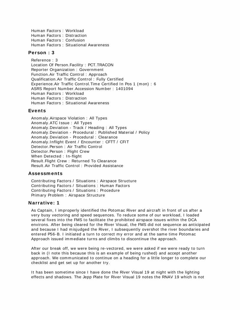
Person : 3 Reference : 3 Location Of Person.Facility : PCT.TRACON Reporter Organization : Government Function.Air Traffic Control : Approach Qualification.Air Traffic Control : Fully Certified Experience.Air Traffic Control.Time Certified In Pos 1 (mon) : 6 ASRS Report Number.Accession Number : 1401094 Human Factors : Workload Human Factors : Distraction Human Factors : Situational Awareness
Events Anomaly.Airspace Violation : All Types Anomaly.ATC Issue : All Types Anomaly.Deviation - Track / Heading : All Types Anomaly.Deviation - Procedural : Published Material / Policy Anomaly.Deviation - Procedural : Clearance Anomaly.Inflight Event / Encounter : CFTT / CFIT Detector.Person : Air Traffic Control Detector.Person : Flight Crew When Detected : In-flight Result.Flight Crew : Returned To Clearance Result.Air Traffic Control : Provided Assistance
Assessments Contributing Factors / Situations : Airspace Structure Contributing Factors / Situations : Human Factors Contributing Factors / Situations : Procedure Primary Problem : Airspace Structure
Narrative: 1 As Captain, I improperly identified the Potomac River and aircraft in front of us after a very busy vectoring and speed sequences. To reduce some of our workload, I loaded several fixes into the FMS to facilitate the prohibited airspace issues within the DCA environs. After being cleared for the River Visual, the FMS did not sequence as anticipated and because I had misjudged the River, I subsequently overshot the river boundaries and entered P56-B. I initiated a turn to correct my error and at the same time Potomac Approach issued immediate turns and climbs to discontinue the approach. After our break off, we were being re-vectored, we were asked if we were ready to turn back in (I note this because this is an example of being rushed) and accept another approach. We communicated to continue on a heading for a little longer to complete our checklist and get set up for another try. It has been sometime since I have done the River Visual 19 at night with the lighting effects and shadows. The Jepp Plate for River Visual 19 notes the RNAV 19 which is not

loaded in our database. This may be useful to look into to see if our databases can accept this. Also, on our other chart info (10-7 and other reference pages), we illustrate the DCA-328 radial as a method of tracking for RWY 1 departures. This could be used as a "boundary" reference for inbound arrivals. I literally forgot about the black-hole this approach sometimes creates. Still, at my level of experience, I am quite disappointed. This event rests solely on my shoulders. Add in our [manual] pages to depict the DCA-328 for RW19 arrivals and RW 1 arrivals/departures unless our FMS database can be updated. This should help reduce our P56 incursions.
Narrative: 2 The occurrence happened flying into DCA on the river visual RW19. [The Captain] is my OE (Operating Experience) instructor and was the pilot flying. It was clear weather and night time. ATC was very busy and had several airplanes in line for the approach. ATC directed us to descend and fly different headings and prompted us several times to find the river and look for traffic for us to follow. The Captain (pilot flying) was very task saturated with requests from ATC. I had the river and eventually the traffic in sight and waited until the Captain said he had both in sight, prompting me to advise ATC we had the river and traffic in sight. We were around FERGI intersection when we accepted approach clearance. I averted my attention to keep my eye on the Airbus a ways in front of us and tended to PM (Pilot Monitoring) duties inside the airplane. I believe the Captain lost sight of the river passed DARIC intersection and neglected to make the right turn to follow the river and instead went straight into Prohibited Area P-56B. We were then immediately instructed to climb and turn away from the Prohibited Area and were canceled approach clearance. We performed a go-around maneuver, ran checklists, re-set up for the approach and attempted it again. The second approach attempt was successful and we landed safely. I personally have never performed a published visual approach in a plane or in the simulator in training; nor have I flown in DCA airspace. As a new hire FO (First Officer) on OE, I relied on my captain's knowledge and experience to be situationally aware with the river visual and procedures going into DCA. I believe incorporation and explanation of this approach in the new hire training program would help fresh co-pilots feel somewhat familiar with the real river visuals into DCA. Had I been more familiar with the procedure, I believe I could have further helped avoid this deviation and aided the pilot flying with performing this approach. This has taught me as pilot monitoring to place more emphasis in looking outside the airplane during critical phases of flight such as a visual approach to further aid the pilot flying in situational awareness. I have also taken away from this situation to initiate a go around or ask for missed approach instructions if I am the pilot flying and have lost sight of the runway/airport or the river (on a published visual approach). And as the pilot monitoring, to query the pilot flying if he/she seems unsure of the situation.
Narrative: 3 [The aircraft] was an arrival into DCA. The pilot was cleared for a Charted Visual Approach to follow traffic. I noticed the aircraft looked off course (left of course landing Runway 19, a south operation). The dilemma with this aircraft is that they were below minimum vectoring altitude in the center of antennas and heading for the White House a Prohibited

Area up to FL180 (P56). I was not sure what to do first except to climb the aircraft to get them out of the antennas and then turn them as to not enter Prohibited Area (P56). With that being said, they had to be turned back toward the final which causes other issues and where there were other aircraft on final. This piece of airspace does not allow for error on anyone's part be it me the Controller or the Pilot. It's an unsafe area because of P56.
Synopsis Flight Crew and Controller reported of the flight being off course and entering Restricted Area P-56. Controller reported of aircraft being below the Minimum Vectoring Altitude and needing to vector aircraft out of P56. Pilot reported of improperly identifying the Potomac River and the aircraft to follow.

ACN: 1401998 (4 of 50)
Time / Day Date : 201611 Local Time Of Day : 1801-2400
Place Locale Reference.Airport : OAK.Airport State Reference : CA Altitude.MSL.Single Value : 4800
Environment Flight Conditions : VMC Light : Night
Aircraft : 1 Reference : X ATC / Advisory.TRACON : NCT Aircraft Operator : Air Carrier Make Model Name : Widebody Transport Crew Size.Number Of Crew : 2 Operating Under FAR Part : Part 121 Flight Plan : IFR Mission : Cargo / Freight Nav In Use : FMS Or FMC Flight Phase : Initial Approach Route In Use.STAR : OAKES2 Airspace.Class E : NCT
Aircraft : 2 Reference : Y ATC / Advisory.TRACON : NCT Make Model Name : Small Aircraft Operating Under FAR Part : Part 91 Mission : Personal Flight Phase : Cruise Airspace.Class E : NCT
Person : 1 Reference : 1 Location Of Person.Aircraft : X Location In Aircraft : Flight Deck Reporter Organization : Air Carrier Function.Flight Crew : Captain Function.Flight Crew : Pilot Flying Qualification.Flight Crew : Air Transport Pilot (ATP) ASRS Report Number.Accession Number : 1401998 Human Factors : Communication Breakdown Human Factors : Workload Communication Breakdown.Party1 : Flight Crew Communication Breakdown.Party2 : ATC

Person : 2 Reference : 2 Location Of Person.Aircraft : X Location In Aircraft : Flight Deck Reporter Organization : Air Carrier Function.Flight Crew : First Officer Function.Flight Crew : Pilot Not Flying Qualification.Flight Crew : Air Transport Pilot (ATP) ASRS Report Number.Accession Number : 1401999 Human Factors : Workload Human Factors : Communication Breakdown Communication Breakdown.Party1 : Flight Crew Communication Breakdown.Party2 : ATC
Events Anomaly.ATC Issue : All Types Anomaly.Conflict : Airborne Conflict Anomaly.Deviation - Altitude : Crossing Restriction Not Met Detector.Automation : Aircraft RA Detector.Person : Flight Crew When Detected : In-flight Result.Flight Crew : FLC complied w / Automation / Advisory Result.Flight Crew : Took Evasive Action
Assessments Contributing Factors / Situations : Airspace Structure Contributing Factors / Situations : Human Factors Contributing Factors / Situations : Procedure Primary Problem : Human Factors
Narrative: 1 While "Descending Via" to 4500 ft on the OAKES 2 RNAV arrival, and after passing waypoint TOOOL, we were subsequently cleared to cross FFIST at and maintain 8000 ft. We complied with that clearance. About 3 nm past FFIST we were cleared to resume descending via the arrival. Because of the delay, we had to expedite our descent to make the mandatory crossing of 4500 ft at PARBB. All the while, ATC was engaged in almost non-stop conversation with numerous VFR aircraft, including VFR flight following and vectors to avoid the OAK arrival corridor. We were never given traffic information, but it sounded as if at least one of the VFR aircraft were given traffic information about us. 2 nm prior to PARBB, while descending at Flaps 1 airspeed (197 kts) we received a TA and almost immediately an RA with a command of "LEVEL OFF, LEVEL OFF". We complied with the RA and reduced our descent rate from 700 FPM to 0 FPM and leveled off at 4800 ft. We maintained 4800 ft until about 2 nm past PARBB when we received "CLEAR OF CONFLICT". We then continued our descent to 4500 ft. We advised ATC of the RA, and received a reply of "Roger". We asked for a continued descent and were cleared to 3000 ft and subsequently cleared for the visual approach to RWY 30 at OAK. The rest of the flight was uneventful. Caused by ATC workload caused by numerous VFR aircraft operating in and around the OAK arrival corridor. The controller was task saturated. [No suggestions] without further restricting VFR traffic. The RA occurred at the bottom of or slightly below the constraints of the Class B airspace around SFO.

Narrative: 2 SFO Class B is very congested, with Hayward field, OAK and SFO traffic patterns in close proximity. The TCAS RA was instrumental in preventing a midair. The traffic triggering the TCAS RA was crossing the Class B, not landing at any nearby field. Increasing VFR pilots' awareness of patterns and perhaps establishing VFR corridors to procedurally avoid IFR approach corridors might help.
Synopsis Air carrier flight crew reported responding to a TCAS RA on arrival into OAK airport. Controller workload with VFR aircraft was contributing.

ACN: 1401551 (5 of 50)
Time / Day Date : 201611 Local Time Of Day : 1801-2400
Place Locale Reference.Airport : ZZZ.Airport State Reference : US Altitude.MSL.Single Value : 2900
Environment Flight Conditions : VMC Weather Elements / Visibility : Haze / Smoke Weather Elements / Visibility.Visibility : 9 Light : Night
Aircraft Reference : X ATC / Advisory.Tower : ZZZ Aircraft Operator : Air Carrier Make Model Name : Regional Jet 900 (CRJ900) Crew Size.Number Of Crew : 2 Operating Under FAR Part : Part 121 Flight Plan : IFR Mission : Passenger Nav In Use : FMS Or FMC Flight Phase : Initial Approach Route In Use : Visual Approach Airspace.Class D : ZZZ
Component Aircraft Component : Company Operations Manual Aircraft Reference : X Problem : Design
Person Reference : 1 Location Of Person.Aircraft : X Location In Aircraft : Flight Deck Reporter Organization : Air Carrier Function.Flight Crew : First Officer Function.Flight Crew : Pilot Not Flying Qualification.Flight Crew : Air Transport Pilot (ATP) ASRS Report Number.Accession Number : 1401551 Human Factors : Confusion Human Factors : Distraction Human Factors : Situational Awareness Human Factors : Training / Qualification Human Factors : Communication Breakdown

Communication Breakdown.Party1 : Flight Crew Communication Breakdown.Party2 : Flight Crew
Events Anomaly.Deviation - Procedural : Published Material / Policy Anomaly.Deviation - Procedural : Clearance Anomaly.Inflight Event / Encounter : Unstabilized Approach Anomaly.Inflight Event / Encounter : CFTT / CFIT Detector.Automation : Aircraft Terrain Warning Detector.Person : Flight Crew When Detected : In-flight Result.Flight Crew : Became Reoriented Result.Flight Crew : Took Evasive Action Result.Flight Crew : Returned To Clearance
Assessments Contributing Factors / Situations : Airport Contributing Factors / Situations : Environment - Non Weather Related Contributing Factors / Situations : Human Factors Contributing Factors / Situations : Procedure Primary Problem : Human Factors
Narrative: 1 We were descending into our final destination and told to expect the visual approach to Runway XXR. Weather was VFR, albeit a bit hazy due to smoke from nearby fires, with a reported visibility of 9 SM. As we descended thru approximately 8,000, I inquired the captain if he would like me to load the RNAV to Runway XXR for added situational awareness, and so we would be prepared in case we were unable to make a visual approach. He agreed, and I programmed the FMS as such. We picked up the field visually approximately 9 miles out and were cleared for the visual approach. ATC had left us a bit high and the captain was hustling down to enter the traffic pattern. He bugged 1,800 feet in the altitude preselector. I immediately found this odd, as the appropriate traffic pattern altitude is 2,500, and the final approach fix altitude is 2,700 on the RNAV. I did not query the captain at that time, as I have seen many techniques for setting the altitude preselect on the autopilot flown portion of the visual approach. In addition, this was complicated by the fact that the captain and I are based here, and likely conduct more visual approaches here than anywhere else in the system. In other words, I (regrettably) assumed that he set the altitude at 1,800 intentionally. Upon descending thru approximately 2,900 ft and a 5 mile base to final, we were still doing roughly 2,000 fpm, at 200 knots, with flaps 8 (I believe), and the captain showed no sign of arresting the descent rate. I immediately became concerned and asked him if he intended to descend all the way to 1,800, as that would take us below 1,000 AGL. The captain immediately realized his mistake and commanded the autopilot to level the aircraft. As the aircraft began to level we received a momentary EGPWS Mode 2A "terrain" caution. To the extent of my knowledge, the aircraft did not go below 2,300 ft. Since we knew the cause of the GPWS message, which was momentary, and were now level, the captain elected to continue the approach. He was a bit flustered, which led him to retract the spoilers later than intended, but managed to configure the aircraft by 1,000 AGL. At that point we were Ref+5 to 10 and the vertical speed was slightly over 1,000 but correcting. He called "stable" and we landed normally. We discussed the event after blocking in, and it became clear what had happened. He had somehow confused the final approach fix on the

RNAV Runway XXR, with a minimum altitude of 1840ft, for the 5 mile fix on the visual approach. In hindsight, I learned a lot from this event. While I did speak up about the captain's error in setting the altitude preselect, I should have done so when I first noticed the anomaly. In addition, I don't think the decision to continue the approach was prudent, and the escape maneuver should have been conducted. The POH is a bit contradictory about this stating that "At night or in IMC, perform the above EGPWS escape maneuver". (After receiving a "TERRAIN" or "PULL UP" warning) The next line states "When an aural warning other than "PULL UP" occurs, initiate the corrective action to remove the cause of the warning". I don't know if this contributed to the Captain's decision to continue the approach, but I believe the line should be amended to read "When an aural warning other than "PULL UP" or "TERRAIN" occurs..." for consistency. This has certainly opened my eyes, and I am certain that, in the future, I will not let something like this progress as far as it did.
Synopsis A CRJ900 First Officer reported the Captain set the level off altitude below 1,000 feet AGL while descending for a night visual. The First Officer finally asked the Captain his intention at which time the EGPWS "TERRAIN" alerted. The descent was arrested without the escape maneuver. The First Officer questioned the Pilot Handbook escape maneuver wording.
ACN: 1400801 (6 of 50)
Time / Day Date : 201611 Local Time Of Day : 1801-2400
Place Locale Reference.Airport : ZZZ.Airport State Reference : US Altitude.MSL.Single Value : 1400
Environment Flight Conditions : IMC Weather Elements / Visibility : Fog Weather Elements / Visibility.Visibility : 4 Light : Night Ceiling.Single Value : 700
Aircraft Reference : X ATC / Advisory.TRACON : ZZZ Aircraft Operator : Personal Make Model Name : Cessna Stationair/Turbo Stationair 6 Operating Under FAR Part : Part 91 Flight Plan : IFR Mission : Personal Nav In Use : FMS Or FMC Flight Phase : Final Approach Route In Use : Vectors Airspace.Class D : ZZZ
Component Aircraft Component : FMS/FMC Aircraft Reference : X
Person Reference : 1 Location Of Person.Aircraft : X Location In Aircraft : Flight Deck Reporter Organization : Personal Function.Flight Crew : Single Pilot Qualification.Flight Crew : Flight Instructor Qualification.Flight Crew : Instrument Experience.Flight Crew.Total : 13000 Experience.Flight Crew.Last 90 Days : 40 Experience.Flight Crew.Type : 60 ASRS Report Number.Accession Number : 1400801 Human Factors : Communication Breakdown Human Factors : Situational Awareness Human Factors : Workload Human Factors : Confusion

Communication Breakdown.Party1 : Flight Crew Communication Breakdown.Party2 : ATC
Events Anomaly.Deviation - Procedural : Published Material / Policy Anomaly.Inflight Event / Encounter : CFTT / CFIT Detector.Person : Air Traffic Control When Detected : In-flight Result.Flight Crew : Took Evasive Action Result.Flight Crew : FLC complied w / Automation / Advisory Result.Flight Crew : Became Reoriented Result.Air Traffic Control : Issued Advisory / Alert
Assessments Contributing Factors / Situations : Aircraft Contributing Factors / Situations : Human Factors Contributing Factors / Situations : Procedure Primary Problem : Human Factors
Narrative: 1 On the RNAV GPS approach I was paying too much attention on the new Garman 750 radio and GPS and received an altitude alert from ATC. I immediately leveled off and broke out and landed with no issues. I should have paid more attention to altitude.
Synopsis A C-206 Pilot received a low altitude alert from ATC while flying a RNAV GPS and concentrating too intently on his new Garman 750.

ACN: 1399158 (7 of 50)
Time / Day Date : 201611 Local Time Of Day : 1201-1800
Place Locale Reference.ATC Facility : BNA.TRACON State Reference : TN Altitude.MSL.Single Value : 6000
Environment Light : Daylight
Aircraft : 1 Reference : X ATC / Advisory.TRACON : BNA Aircraft Operator : Air Carrier Make Model Name : Medium Large Transport, Low Wing, 2 Turbojet Eng Crew Size.Number Of Crew : 2 Operating Under FAR Part : Part 121 Flight Plan : IFR Mission : Passenger Nav In Use : FMS Or FMC Nav In Use : GPS Flight Phase : Initial Approach Route In Use.Other Airspace.Class E : BNA
Aircraft : 2 Reference : Y ATC / Advisory.TRACON : BNA Aircraft Operator : Corporate Make Model Name : Small Transport, Low Wing, 2 Turbojet Eng Crew Size.Number Of Crew : 2 Operating Under FAR Part : Part 91 Flight Plan : IFR Mission : Passenger Flight Phase : Initial Approach Route In Use : Vectors Airspace.Class E : BNA
Person Reference : 1 Location Of Person.Facility : BNA.TRACON Reporter Organization : Government Function.Air Traffic Control : Approach Qualification.Air Traffic Control : Fully Certified Experience.Air Traffic Control.Time Certified In Pos 1 (yrs) : 15 ASRS Report Number.Accession Number : 1399158 Human Factors : Workload
Human Factors : Communication Breakdown Communication Breakdown.Party1 : ATC Communication Breakdown.Party2 : ATC Analyst Callback : Completed
Events Anomaly.ATC Issue : All Types Anomaly.Conflict : Airborne Conflict Anomaly.Deviation - Track / Heading : All Types Anomaly.Deviation - Procedural : Published Material / Policy Anomaly.Deviation - Procedural : Clearance Detector.Person : Air Traffic Control When Detected : In-flight Result.Air Traffic Control : Issued New Clearance Result.Air Traffic Control : Provided Assistance Result.Air Traffic Control : Separated Traffic
Assessments Contributing Factors / Situations : Chart Or Publication Contributing Factors / Situations : Human Factors Contributing Factors / Situations : Procedure Primary Problem : Procedure
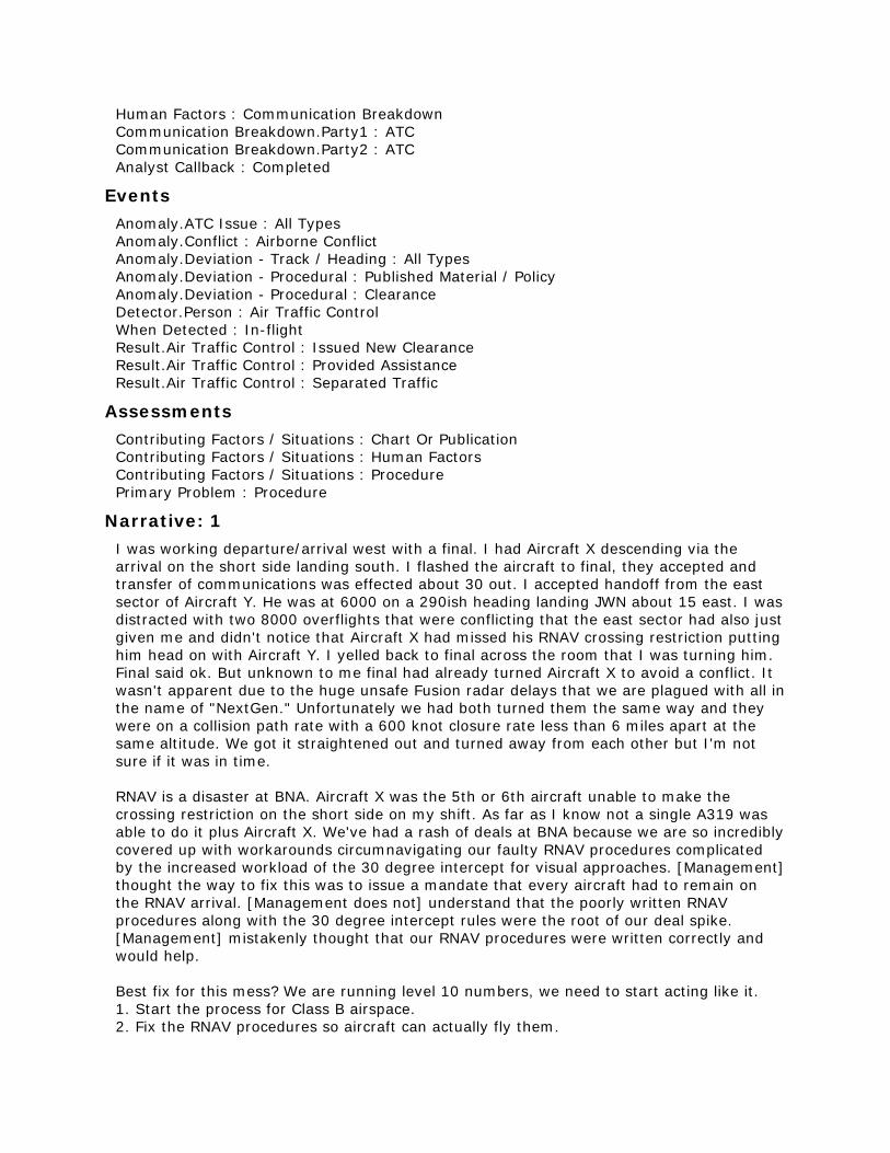
Narrative: 1 I was working departure/arrival west with a final. I had Aircraft X descending via the arrival on the short side landing south. I flashed the aircraft to final, they accepted and transfer of communications was effected about 30 out. I accepted handoff from the east sector of Aircraft Y. He was at 6000 on a 290ish heading landing JWN about 15 east. I was distracted with two 8000 overflights that were conflicting that the east sector had also just given me and didn't notice that Aircraft X had missed his RNAV crossing restriction putting him head on with Aircraft Y. I yelled back to final across the room that I was turning him. Final said ok. But unknown to me final had already turned Aircraft X to avoid a conflict. It wasn't apparent due to the huge unsafe Fusion radar delays that we are plagued with all in the name of "NextGen." Unfortunately we had both turned them the same way and they were on a collision path rate with a 600 knot closure rate less than 6 miles apart at the same altitude. We got it straightened out and turned away from each other but I'm not sure if it was in time. RNAV is a disaster at BNA. Aircraft X was the 5th or 6th aircraft unable to make the crossing restriction on the short side on my shift. As far as I know not a single A319 was able to do it plus Aircraft X. We've had a rash of deals at BNA because we are so incredibly covered up with workarounds circumnavigating our faulty RNAV procedures complicated by the increased workload of the 30 degree intercept for visual approaches. [Management] thought the way to fix this was to issue a mandate that every aircraft had to remain on the RNAV arrival. [Management does not] understand that the poorly written RNAV procedures along with the 30 degree intercept rules were the root of our deal spike. [Management] mistakenly thought that our RNAV procedures were written correctly and would help. Best fix for this mess? We are running level 10 numbers, we need to start acting like it. 1. Start the process for Class B airspace. 2. Fix the RNAV procedures so aircraft can actually fly them.

3. Fix the RNAV departures so the aircraft can transition to Center airspace with no other response than "radar contact" our RNAV stops at 4000. Unbelievable. 4. We've checked out a lot of people here on the "train to succeed program." We need higher standards. We are now the busiest facility in the hub, we are woefully understaffed for our peak hours. 5. Bring back final monitors from the hub and run simos. 6. Currently, in our last briefing, we were told we could no longer use lateral separation but only altitude in the final box until both aircraft were established. This is unworkable, there aren't enough available altitudes. I was told that this knee jerk reaction from [management] is to avoid the scrutiny of the Tiger team due to our 45+ deals in the last 6 months. Please, please send the Tiger team. I don't have any faith in our leadership.
Callback: 1 Reporter stated BNA has had FUSION RADAR for 3-4 years and the STARS does not update soon enough so target data blocks lag to catch the target by about 5 seconds. The reporter advised that nothing is being done that he is aware of to fix the lag. Referencing the RNAV issue, the amount of operational errors has increased over the same amount of time (3-4 years) and is related to aircraft not flying the procedures correctly and the amount of airspace in the final area. Reporter advised there is a committee looking into changing the RNAV procedures, but they are taking too long to come up with a solution.
Synopsis BNA TRACON Controller reported an unsafe situation related to the Fusion radar and the use of RNAV procedures.
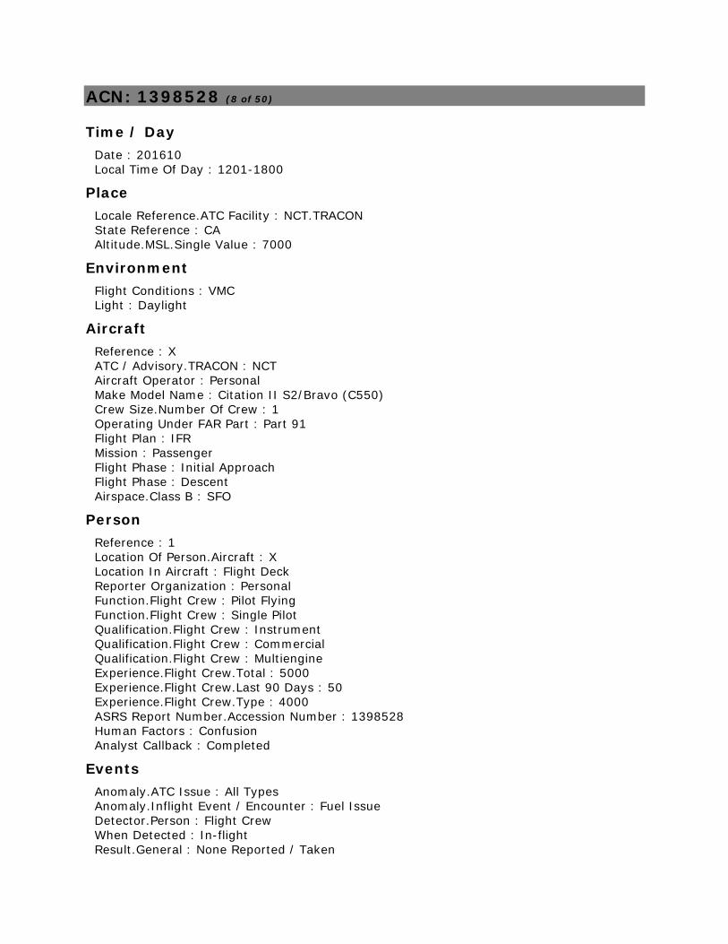
ACN: 1398528 (8 of 50)
Time / Day Date : 201610 Local Time Of Day : 1201-1800
Place Locale Reference.ATC Facility : NCT.TRACON State Reference : CA Altitude.MSL.Single Value : 7000
Environment Flight Conditions : VMC Light : Daylight
Aircraft Reference : X ATC / Advisory.TRACON : NCT Aircraft Operator : Personal Make Model Name : Citation II S2/Bravo (C550) Crew Size.Number Of Crew : 1 Operating Under FAR Part : Part 91 Flight Plan : IFR Mission : Passenger Flight Phase : Initial Approach Flight Phase : Descent Airspace.Class B : SFO
Person Reference : 1 Location Of Person.Aircraft : X Location In Aircraft : Flight Deck Reporter Organization : Personal Function.Flight Crew : Pilot Flying Function.Flight Crew : Single Pilot Qualification.Flight Crew : Instrument Qualification.Flight Crew : Commercial Qualification.Flight Crew : Multiengine Experience.Flight Crew.Total : 5000 Experience.Flight Crew.Last 90 Days : 50 Experience.Flight Crew.Type : 4000 ASRS Report Number.Accession Number : 1398528 Human Factors : Confusion Analyst Callback : Completed
Events Anomaly.ATC Issue : All Types Anomaly.Inflight Event / Encounter : Fuel Issue Detector.Person : Flight Crew When Detected : In-flight Result.General : None Reported / Taken

Assessments Contributing Factors / Situations : Airspace Structure Contributing Factors / Situations : Procedure Primary Problem : Ambiguous
Narrative: 1 WE were on a modified version of the WNDSR arrival. HWD is not included in the WNDSR (which is a serious omission). So I was flying RBUCL WNDSR REBAS OAK HWD. This is what FAA recommended when I complained that HWD was not included in the WNDSR arrival. Everything was normal and I was just leveling at 7000 about 5 minutes from REBAS when I was told I was going to have to hold. The airport was VFR but Norcal said they were too busy to take the handoff from Center. Mind you this is midday and not a lot of traffic. So I was told to hold on the 330 [radial] northwest of SGD. I said okay but we had been in flight for 4:05 and we could not hold for very long. Controller said she would pass on that we were tight on fuel. We were given an efc of (15 minutes). We had to make two complete turns in the pattern. We were then cleared direct REBAS and handed to NORCAL. AT this point I am only slightly annoyed with the handling. I had to hold. No one else was holding, it was just Norcal being snippy about HWD. Norcal then cleared us direct OAK and then gave heading. Then we were vectored way out of the way and in a circle over LVK even though we were fuel critical. She even cleared a practice approach in front of us. I had to radio again that we were getting low on fuel. This is totally unacceptable. It isn't like it was heavy IFR at TEB. There was absolutely no coordination between the controller that was handling me on the final handoff before the tower and the prior. I don't think she even got the message that I was low on fuel. This total lack of coordination and communication is unacceptable but not infrequent. I landed just under my reserve fuel. I was never in a position to have to declare an emergency but I was close. But it was totally avoidable. I could hear the traffic she was vectoring us around. She should have prioritized us. I got the number and was going to call the Tracon Chief but I decided I was too mad. So I am using this forum. I am still very mad about this poor handling. This was a lousy job done by the controller(s) and it is exacerbated by the fact that when they added the RNAV arrivals to the bay area they left HWD out of all of them. We were in all of them before the airspace update. There are lots of jets using HWD and more coming. A new FBO just opened this week. I would like some answers and some accountability.
Callback: 1 Reporter reiterated his statement that the route he filed was the route he was instructed to fly in the absence of a WNDSR transition to HWD. He believes that the WNDSR arrival should still be allowed to serve HWD although it does not, after the most recent revision to bay area airport arrival procedures.
Synopsis CE550 Captain reported being issued holding instructions during arrival to HWD via a modified WNDSR2 STAR, on a VMC day with light traffic. After two turns in the holding pattern and stating low fuel, he is vectored out over the Livermore valley and turned in behind a practice approach to HWD.

ACN: 1398306 (9 of 50)
Time / Day Date : 201610 Local Time Of Day : 0001-0600
Place Locale Reference.ATC Facility : P50.TRACON State Reference : AZ Altitude.MSL.Single Value : 13000
Environment Flight Conditions : VMC Light : Dawn
Aircraft Reference : X ATC / Advisory.TRACON : P50 Aircraft Operator : Air Carrier Make Model Name : MD-11 Crew Size.Number Of Crew : 2 Operating Under FAR Part : Part 121 Flight Plan : IFR Mission : Passenger Flight Phase : Descent Route In Use.STAR : EAGUL6 Airspace.Class E : P50
Person Reference : 1 Location Of Person.Aircraft : X Location In Aircraft : Flight Deck Reporter Organization : Air Carrier Function.Flight Crew : Pilot Flying Function.Flight Crew : Captain Qualification.Flight Crew : Air Transport Pilot (ATP) ASRS Report Number.Accession Number : 1398306 Human Factors : Situational Awareness Human Factors : Workload
Events Anomaly.ATC Issue : All Types Anomaly.Deviation - Altitude : Overshoot Anomaly.Deviation - Altitude : Crossing Restriction Not Met Anomaly.Deviation - Speed : All Types Anomaly.Deviation - Procedural : Clearance Detector.Person : Flight Crew When Detected : In-flight Result.Flight Crew : Returned To Clearance Result.Flight Crew : Became Reoriented

Assessments Contributing Factors / Situations : Human Factors Contributing Factors / Situations : Procedure Primary Problem : Procedure
Narrative: 1 Captain was PF (Pilot Flying). We were approaching ZUNI for the EAGUL 6 RNAV STAR into PHX and were subsequently cleared direct to HOMRR intersection and cleared to descend via the EAGUL 6. Approaching FL200 we were handed off to Phoenix Approach who directed us to delete the speed restrictions. The F/O (First Officer) deleted the five speed restrictions in front of us on the arrival. The aircraft had just adjusted the profile for roughly 300 KIAS when we were told to comply with the speed restrictions. We were 4-5 NM from HOMRR with a restriction of 250/17000 feet. I bow-tied the speed and applied full spoilers while the F/O went back to reinserting the remaining four speeds. We made the altitude restriction at 17000 feet but were roughly 20 kts fast as we crossed HOMRR. As soon as the FMS sequenced HOMRR the autopilot commanded an aggressive descent of 5500-6000 feet/minute. The next waypoint was BOHTX with an altitude restriction of 13000-14000 feet. As soon as I recognized the descent I reverted to V/S and commanded a level off. We overshot the 13000 foot restriction by about 300 feet one mile short of BOHTX. After BOHTX we continued the arrival without any further problems. ATC did not say anything about either the airspeed or altitude deviation. Being cleared to descend at a higher than normal speed, then being told to meet speed restrictions in close to the first waypoint put us behind to the point that we couldn't make both the airspeed and altitude restrictions. I felt the altitude was more important at that time and did the best I could with the speed. I don't know why PROF (Profile) commanded such an aggressive descent, but by the time I caught it we were too close to the 13000 foot altitude to avoid overshooting it. PF has to be totally engaged with what the jet's doing at all times. I could have probably detected the overly aggressive descent sooner if I hadn't been worrying about getting down-track speed restrictions put back in. Using a lower mode of automation (bow tie) and leaving the speed restrictions in place just in case they're reinstated will reduce the heads down workload of the PF who would then be better able to detect deviations faster. ATC needs to be aware that we can't slow down/descend on a dime and/or make altitude and airspeed restrictions if they drive us in too close before issuing the instruction.
Synopsis MD-11 Captain reported difficulty complying with multiple short-notice clearance changes on arrival into PHX.

ACN: 1397559 (10 of 50)
Time / Day Date : 201610 Local Time Of Day : 0601-1200
Place Locale Reference.Airport : ZZZ.Airport State Reference : US Altitude.AGL.Single Value : 0
Environment Flight Conditions : VMC
Aircraft Reference : X ATC / Advisory.Tower : ZZZ Aircraft Operator : Air Carrier Make Model Name : B737-900 Crew Size.Number Of Crew : 2 Operating Under FAR Part : Part 121 Flight Plan : IFR Mission : Passenger Flight Phase : Landing
Person : 1 Reference : 1 Location Of Person.Aircraft : X Location In Aircraft : Flight Deck Reporter Organization : Air Carrier Function.Flight Crew : Pilot Flying Function.Flight Crew : First Officer Qualification.Flight Crew : Air Transport Pilot (ATP) Experience.Flight Crew.Type : 186 ASRS Report Number.Accession Number : 1397559 Human Factors : Situational Awareness
Person : 2 Reference : 2 Location Of Person.Aircraft : X Location In Aircraft : Cabin Jumpseat Cabin Activity : Safety Related Duties Reporter Organization : Air Carrier Function.Flight Attendant : Flight Attendant (On Duty) Function.Flight Attendant : Flight Attendant In Charge Qualification.Flight Attendant : Current Experience.Flight Attendant.Airline Total : 18 Experience.Flight Attendant.Number Of Acft Qualified On : 8 Experience.Flight Attendant.Type : 30 ASRS Report Number.Accession Number : 1399687

Person : 3 Reference : 3 Location Of Person.Aircraft : X Location In Aircraft : Flight Deck Reporter Organization : Air Carrier Function.Flight Crew : Check Pilot Function.Flight Crew : Captain Function.Flight Crew : Pilot Not Flying Qualification.Flight Crew : Air Transport Pilot (ATP) Experience.Flight Crew.Type : 1678 ASRS Report Number.Accession Number : 1397584 Human Factors : Situational Awareness
Person : 4 Reference : 4 Location Of Person.Aircraft : X Location In Aircraft : Cabin Jumpseat Cabin Activity : Safety Related Duties Reporter Organization : Air Carrier Function.Flight Attendant : Flight Attendant (On Duty) Qualification.Flight Attendant : Current Experience.Flight Attendant.Airline Total : 17 Experience.Flight Attendant.Type : 100 ASRS Report Number.Accession Number : 1398870
Person : 5 Reference : 5 Location Of Person.Aircraft : X Location In Aircraft : Cabin Jumpseat Cabin Activity : Safety Related Duties Reporter Organization : Air Carrier Function.Flight Attendant : Flight Attendant (On Duty) Qualification.Flight Attendant : Current ASRS Report Number.Accession Number : 1399152
Events Anomaly.Deviation - Procedural : Other / Unknown Detector.Person : Flight Crew Detector.Person : Flight Attendant When Detected : In-flight Result.General : Physical Injury / Incapacitation Result.General : Maintenance Action
Assessments Contributing Factors / Situations : Human Factors Primary Problem : Human Factors
Narrative: 1 Conducting RNAV RNP approach in VMC conditions. Stable descent from altitude and made a glide slope correction at approximately 100 feet AGL in a timely manner. Flared at 20

feet which could have been more aggressive to break rate of descent. Rollout and parking normal.
Narrative: 2 I experienced the hardest landing in my career. As a result of this landing, 6 flight attendants were hurt. The flight was scheduled to be a routine flight with the exception of the First Officer being on his IOE flight. Things played out differently on landing. The aircraft slammed into the ground. My arms went flying into the air. I thought we had crashed. When we parked at the gate, we had to wait to deplane. The ramp had to unload the bags from the tail cargo pit to avoid tipping over. Our cockpit crew left shortly after the front door opened and during our passenger deplaning. The outbound inflight crew and cockpit crew were waiting by the customer service podium when we exited the jet bridge. They seemed shocked by our experience. They said they had no prior notification or documentation of the incident. I am glad we were able to communicate this information. I felt the aircraft needed to be inspected by a mechanic. I tracked the outbound flight while I was waiting to be seen by medical personnel. It appears that the flight back had to wait for another aircraft to arrive. I felt more at ease knowing they were not taking the aircraft [we landed in] back.
Narrative: 3 On final approach during RNAV RNP approach in VMC, a correction was made from above gradient path to on path in a timely manner. At approximately 20 feet AGL the flare was initiated but given the conditions should have been initiated earlier and/or more aggressively.
Narrative: 4 While getting ready to land we heard this loud bang, then I flailed almost out of my jumpseat while strapped in, and my head was forced back into my jumpseat. I was awaiting orders from the Captain to evacuate, but to no avail. I thought we had crashed or had maybe a flat tire. I remember asking the Captain what happened his reply was I'll take the blame, but no question as to if we (the crew) were alright. He and First Officer left and once everyone had deplaned I was informed from my crew of back injuries. I have been flying for almost 18 years and never had a landing like that. In the future I believe the Captain should also check with the crew, before exiting the aircraft, when a landing of that type has occurred. The 737-900 or 800 to me are not really made for commercial airlines and should be re-accessed for flying.
Narrative: 5 I was sitting at 2L outboard in my brace position when we experienced a hard landing. It seemed to be a usual landing, there was nothing out of the ordinary until we hit the runway. We hit the runway so hard that I was "bounced" around in my jumpseat. I thought we had crashed. I was relieved to hear the purser come on the PA and make an announcement that we had landed in ZZZ. Unfortunately, the pilot never made an announcement upon landing nor did he call to check on the crew. There were five crew members who were checked out at the medical center.
Synopsis

B737 flight crew and three flight attendants reported a hard landing that caused the flight attendants to seek medical attention. The flying First Officer was receiving IOE training.

ACN: 1396613 (11 of 50)
Time / Day Date : 201610 Local Time Of Day : 0001-0600
Place Locale Reference.Airport : IAD.Airport State Reference : DC Altitude.AGL.Single Value : 300
Environment Light : Night
Aircraft Reference : X ATC / Advisory.Tower : IAD Aircraft Operator : Air Carrier Make Model Name : Commercial Fixed Wing Crew Size.Number Of Crew : 2 Operating Under FAR Part : Part 121 Flight Plan : IFR Mission : Passenger Nav In Use.Localizer/Glideslope/ILS : Runway 01L Flight Phase : Final Approach Airspace.Class B : IAD
Person Reference : 1 Location Of Person.Aircraft : X Location In Aircraft : Flight Deck Reporter Organization : Air Carrier Function.Flight Crew : First Officer Function.Flight Crew : Pilot Not Flying Qualification.Flight Crew : Air Transport Pilot (ATP) Experience.Flight Crew.Total : 13000 Experience.Flight Crew.Last 90 Days : 60 Experience.Flight Crew.Type : 1039 ASRS Report Number.Accession Number : 1396613
Events Anomaly.Deviation - Procedural : Published Material / Policy Anomaly.Inflight Event / Encounter : Unstabilized Approach Detector.Person : Flight Crew When Detected : In-flight
Assessments Contributing Factors / Situations : Procedure Primary Problem : Procedure
Narrative: 1

Following the glideslope on 1R is fraught with danger and results in a less than perfect stabilized approach. The flightpath distance from 1R threshold to 30 is about a mile so the minimum that one would be low on a 3-degree descent path to 30 is 320. A level off at 300-400 feet is common but so is a shallow descent, each of which have one banking fairly low to the ground. Both of these will get you 4 red lights on the 30 PAPI. This is not a great technique but I would bet it is the most common.
Synopsis Air Carrier First Officer reported that when flying the ILS RWY 1R circle to land runway 30 at IAD following the glideslope sets one up for an unstabilized approach and questions why there is not an RNAV or FMS visual to runway 30.

ACN: 1395538 (12 of 50)
Time / Day Date : 201610 Local Time Of Day : 1201-1800
Place Locale Reference.ATC Facility : MMEX.ARTCC State Reference : FO
Environment Flight Conditions : VMC Light : Daylight
Aircraft Reference : X ATC / Advisory.Center : MMEX Aircraft Operator : Air Carrier Make Model Name : B737 Undifferentiated or Other Model Crew Size.Number Of Crew : 2 Operating Under FAR Part : Part 121 Flight Plan : IFR Mission : Passenger Nav In Use : FMS Or FMC Flight Phase : Descent Route In Use : Vectors Route In Use.STAR : TIKEB1C
Person Reference : 1 Location Of Person.Aircraft : X Location In Aircraft : Flight Deck Reporter Organization : Air Carrier Function.Flight Crew : Pilot Not Flying Function.Flight Crew : Captain Qualification.Flight Crew : Air Transport Pilot (ATP) Experience.Flight Crew.Type : 297 ASRS Report Number.Accession Number : 1395538 Human Factors : Confusion Human Factors : Workload Human Factors : Communication Breakdown Communication Breakdown.Party1 : Flight Crew Communication Breakdown.Party2 : ATC
Events Anomaly.ATC Issue : All Types Detector.Person : Flight Crew When Detected : In-flight Result.Flight Crew : Requested ATC Assistance / Clarification Result.Air Traffic Control : Issued New Clearance

Assessments Contributing Factors / Situations : Procedure Contributing Factors / Situations : Human Factors Primary Problem : Human Factors
Narrative: 1 We had thoroughly briefed/reviewed the cleared route of TIKEB1C STAR MAVEK transition to the ILS 5R approach into MMMX. Approximately 5 minutes prior to the top of descent, ATC gave us a clearance to turn left to a heading of 060 and intercept the SLM 340 radial into SLM for the arrival, and descend and maintain FL350. We complied with the turn and altitude clearance while also building the new course into the FMC. A few minutes later ATC then told us to instead intercept SLM 360 radial inbound. I queried the Controller because neither of those radials lined up with an expected STAR. ATC then said we can expect the SASUT1C arrival, but for now to intercept SLM 360 inbound. We complied again with the new change. While flying inbound on the SLM 360 radial, ATC cleared us to descend while complying with the arrival altitudes. We were still not on a published segment of the arrival. I queried again about these revised clearances not being part of any arrival. ATC advised us that due to traffic they needed to keep adjusting our route and airspeed. To comply, we then had to build into the FMC both DME arcs with the charted altitude and speed values for the descent clearance given. This took several minutes to build into the FMC. Soon after we had that set up, ATC then told us to turn right to a 180 heading and to intercept the San Mateo 300 radial inbound and to descend to 13000'. I advised the Controller that we didn't know what the identifier for San Mateo was (it was not on our STAR or expected approach). I asked again, and was still not given the identifier for San Mateo. I advised ATC that we were unable to comply with the clearance, and that we were being given way too many changes for our arrival. The Controller did not respond to our statement, and told us to contact a different ATC frequency. In the meantime another aircraft told us the identifier for San Mateo (SMO) over the radio. We then built the requested intercept radial off SMO after clarifying it again twice with the next ATC. This new Controller confirmed our routing. Shortly after that, ATC changed our route again to: "proceed direct MAVEK and cleared for the RNAV ILS 05R." We complied with direct MAVEK and prepared to fly the approach after the MAVEK fix. Several additional lower altitudes and airspeeds were given to us by this Controller (too many to accurately remember however). We were scrambling this entire time trying to keep up with all the different clearances being issued. At one point, I asked the FO to concentrate on just flying the aircraft, while I build and rebuilt multiple times all the different clearances into the FMC as they were being issued.
Synopsis B737 NG Captain reported receiving multiple confusing clearance changes on arrival into MMMX that greatly increased workload.

ACN: 1394412 (13 of 50)
Time / Day Date : 201610 Local Time Of Day : 0601-1200
Place Locale Reference.Airport : EWR.Airport State Reference : NJ
Environment Flight Conditions : VMC Light : Daylight
Aircraft : 1 Reference : X ATC / Advisory.Tower : EWR Make Model Name : Commercial Fixed Wing Crew Size.Number Of Crew : 2 Flight Plan : IFR Mission : Passenger Nav In Use : GPS Flight Phase : Taxi Flight Phase : Landing Airspace.Class B : EWR
Aircraft : 2 Reference : Y ATC / Advisory.Tower : EWR Make Model Name : Commercial Fixed Wing Flight Plan : IFR Flight Phase : Landing Flight Phase : Taxi Airspace.Class B : EWR
Person Reference : 1 Location Of Person.Aircraft : X Location In Aircraft : Flight Deck Reporter Organization : Air Carrier Function.Flight Crew : Captain Function.Flight Crew : Pilot Flying Qualification.Flight Crew : Air Transport Pilot (ATP) ASRS Report Number.Accession Number : 1394412
Events Anomaly.ATC Issue : All Types Anomaly.Conflict : Ground Conflict, Less Severe Detector.Person : Flight Crew When Detected : In-flight

Result.Air Traffic Control : Issued Advisory / Alert Result.Air Traffic Control : Separated Traffic
Assessments Contributing Factors / Situations : Airport Contributing Factors / Situations : Environment - Non Weather Related Contributing Factors / Situations : Procedure Primary Problem : Procedure
Narrative: 1 On RNAV approach to runway 11. As soon as we switched to tower, controller tells us to slow to final approach speed because spacing "may be an issue with 4R arrival, but it should be fine". We extended gear and flaps asap and slowed to target speed. Just outside the final approach fix I asked the First Officer to query ATC about spacing since controller seemed uncertain in first transmission. Tower responds that spacing is fine and we are cleared to land 11. I decide to land and stop before intersection of 4R, although we weren't given a LAHSO. As we are exiting runway 11 onto taxiway R we notice that aircraft is exiting 4R at same time (K or P4 I believe). Appeared to us after the fact that we arrived and landed at same time as other aircraft, and not staggered.
Synopsis Air carrier Captain reported observing another aircraft that appeared to have landed in close proximity on a crossing runway at EWR airport.

ACN: 1393844 (14 of 50)
Time / Day Date : 201610 Local Time Of Day : 1201-1800
Place Locale Reference.Airport : RSW.Airport State Reference : FL Altitude.MSL.Single Value : 10000
Environment Flight Conditions : VMC Light : Daylight
Aircraft Reference : X ATC / Advisory.TRACON : RSW Aircraft Operator : Air Carrier Make Model Name : B737 Undifferentiated or Other Model Crew Size.Number Of Crew : 2 Operating Under FAR Part : Part 121 Flight Plan : IFR Mission : Passenger Nav In Use : FMS Or FMC Flight Phase : Initial Approach Route In Use.STAR : TYNEE1 Airspace.Class E : RSW
Person Reference : 1 Location Of Person.Aircraft : X Location In Aircraft : Flight Deck Reporter Organization : Air Carrier Function.Flight Crew : Captain Function.Flight Crew : Pilot Not Flying Qualification.Flight Crew : Air Transport Pilot (ATP) Experience.Flight Crew.Last 90 Days : 227 Experience.Flight Crew.Type : 20000 ASRS Report Number.Accession Number : 1393844 Human Factors : Communication Breakdown Communication Breakdown.Party1 : Flight Crew Communication Breakdown.Party2 : ATC
Events Anomaly.ATC Issue : All Types Detector.Person : Flight Crew When Detected : In-flight Result.Flight Crew : Requested ATC Assistance / Clarification Result.Flight Crew : Became Reoriented Result.Air Traffic Control : Provided Assistance

Assessments Contributing Factors / Situations : Airport Contributing Factors / Situations : Human Factors Contributing Factors / Situations : Procedure Primary Problem : Procedure
Narrative: 1 On TYNEE 1 Arrival, at initial check-in with Approach, reported information XXX. It included that RSW was landing with visual approaches to Runway 06. On check-in, Approach failed to assign a runway or transition on the STAR. We were only assigned to descend and maintain 6000 ft. Since the RNAV arrival splits in the event of a Runway 24 operation, I queried which arrival transition we were to fly, since quick programming would be required if it were to change. The Controller replied that she didn't need to assign a runway since I checked in with the ATIS. I then stated that on an RNAV arrival we needed to know the transition. She said she didn't understand what I was asking? In truth, all she needed to do was give me the requested information and provide the service that she is paid to provide. A new Controller then took over, gave us a descent, and assigned a heading, now I knew what we needed to do. The first Controller was annoyed with my query. Maybe in her mind, it is obvious what is expected in RSW. When it comes to RNAV arrivals, in light of all the complexities involved at numerous airports, I think standardization is extremely important. If they want us to fly a specific transition to a specific runway without conversation then this needs to be spelled out in the ATIS. It was not. Is a change needed to the controller handbook? I do not know.
Synopsis B737 Captain reported difficulty getting cooperation with ATC concerning which STAR transition to fly.

ACN: 1393738 (15 of 50)
Time / Day Date : 201610 Local Time Of Day : 0001-0600
Place Locale Reference.Airport : JFK.Airport State Reference : NY Relative Position.Distance.Nautical Miles : 10 Altitude.MSL.Single Value : 3000
Environment Flight Conditions : VMC Light : Night
Aircraft Reference : X ATC / Advisory.Tower : JFK Aircraft Operator : Air Carrier Make Model Name : A320 Crew Size.Number Of Crew : 2 Operating Under FAR Part : Part 121 Flight Plan : IFR Mission : Ferry Flight Phase : Initial Approach
Person Reference : 1 Location Of Person.Aircraft : X Location In Aircraft : Flight Deck Reporter Organization : Air Carrier Function.Flight Crew : Captain Function.Flight Crew : Pilot Not Flying Qualification.Flight Crew : Instrument Qualification.Flight Crew : Air Transport Pilot (ATP) Qualification.Flight Crew : Multiengine Qualification.Flight Crew : Flight Engineer Experience.Flight Crew.Total : 30000 Experience.Flight Crew.Last 90 Days : 30 Experience.Flight Crew.Type : 10000 ASRS Report Number.Accession Number : 1393738 Human Factors : Communication Breakdown Human Factors : Situational Awareness Communication Breakdown.Party1 : Flight Crew Communication Breakdown.Party2 : Flight Crew
Events Anomaly.Deviation - Altitude : Excursion From Assigned Altitude Anomaly.Deviation - Procedural : Published Material / Policy Anomaly.Deviation - Procedural : Clearance

Detector.Person : Flight Crew Detector.Person : Air Traffic Control When Detected : In-flight Result.Flight Crew : Overcame Equipment Problem Result.Flight Crew : Became Reoriented Result.Air Traffic Control : Provided Assistance
Assessments Contributing Factors / Situations : Human Factors Primary Problem : Human Factors
Narrative: 1 First Officer was flying and briefed the approach to JFK for the RNAV RNP 13L. Part of the briefing included the altimeter setting from the ATIS. The captain acknowledged the altimeter setting but did not crosscheck it on the ATIS. First Officer commenced approach and at final approach fix both pilots recognized that aircraft was high even though instruments showed that it was on the glide path for the RNP. Captain advised the first officer to execute a soft go-around and tower asked the reason for the go-around to which captain stated that they were too high to complete the approach. Tower gave a clearance to climb to 2,000 feet and switch back to approach control. Approach control vectored aircraft back for the same approach. The controller cleared the aircraft for approach by saying "Cleared direct Asalt. Maintain 3,000 or above until passing Asalt, cleared for the RNAV RNP approach to runway 13L." The captain read back the clearance, but questioned the altitude because he said he was at 2,000 feet, not 3,000 feet. The controller said he showed the aircraft at 3,000 feet and stated the altimeter setting which was 30.19. Both pilots had 29.19 set causing the aircraft to appear to be 1,000 feet lower than it actually was. The altimeters were reset and an uneventful approach and landing were accomplished. It should be noted that both pilots had been on duty for nearly 16 hours. There was no conflicting traffic in the area during the either approach.
Synopsis A320 flight crew reported they did not set altimeters correctly and ended up high on the first approach which necessitated a go-around.

ACN: 1393562 (16 of 50)
Time / Day Date : 201610 Local Time Of Day : 1201-1800
Place Locale Reference.ATC Facility : S56.TRACON State Reference : UT Altitude.MSL.Single Value : 13000
Environment Flight Conditions : VMC Light : Daylight
Aircraft Reference : X ATC / Advisory.TRACON : S56 Aircraft Operator : Air Carrier Make Model Name : Medium Large Transport Crew Size.Number Of Crew : 2 Operating Under FAR Part : Part 121 Flight Plan : IFR Mission : Passenger Flight Phase : Descent Airspace.Class E : S56
Person : 1 Reference : 1 Location Of Person.Aircraft : X Location In Aircraft : Flight Deck Reporter Organization : Air Carrier Function.Flight Crew : First Officer Function.Flight Crew : Pilot Not Flying Qualification.Flight Crew : Air Transport Pilot (ATP) ASRS Report Number.Accession Number : 1393562 Human Factors : Communication Breakdown Communication Breakdown.Party1 : Flight Crew Communication Breakdown.Party2 : Flight Crew
Person : 2 Reference : 2 Location Of Person.Aircraft : X Location In Aircraft : Flight Deck Reporter Organization : Air Carrier Function.Flight Crew : Captain Function.Flight Crew : Pilot Not Flying Qualification.Flight Crew : Air Transport Pilot (ATP) ASRS Report Number.Accession Number : 1393564 Human Factors : Communication Breakdown

Communication Breakdown.Party1 : Flight Crew Communication Breakdown.Party2 : Flight Crew
Events Anomaly.Deviation - Altitude : Crossing Restriction Not Met Anomaly.Deviation - Track / Heading : All Types Anomaly.Deviation - Procedural : Clearance Anomaly.Deviation - Procedural : Published Material / Policy
Assessments Contributing Factors / Situations : Human Factors Primary Problem : Human Factors
Narrative: 1 On my IOE (Initial Operating Experience) trip I was PM (Pilot Monitoring) on the last flight of the day. During descent we were given a late hand off from Center to Approach. Approach gave us the NORDK 4 RNAV arrival into SLC and we were given a "descend via" clearance and CARTR at FL190 and 280KTS. We were set up for landing South. I had gotten the ATIS which had advised landing North. As PM I failed to communicate that information to the PF and he was planning on landing South. We continued our descent as if we were landing South, but then realized our error. We then corrected our error and set up for North flow. ATC then asked us if we were set up for landing South or North because it appeared we were set up to land South. We had already corrected our route and were direct SETTT, and descending through 13,000ft, 2,000ft lower than the next crossing restriction on the North flow, which was SETTT @ 15,000ft. We leveled off at 13,000ft and were direct SETTT. We then continued the arrival as ATC had cleared us for. There were no separation issues or any other irregularities on the rest of the arrival. ATC did not give any further instructions and we thanked them for their assistance.
Narrative: 2 [Report narrative contained no additional information.]
Synopsis Air carrier flight crew set up for the wrong direction SLC airport STAR. Flight crew communication was cited as a contributing factor.

ACN: 1393533 (17 of 50)
Time / Day Date : 201610 Local Time Of Day : 1201-1800
Place Locale Reference.Airport : ZZZZ.Airport State Reference : FO Altitude.AGL.Single Value : 0
Environment Flight Conditions : VMC Light : Daylight
Aircraft Reference : X ATC / Advisory.Tower : ZZZZ Aircraft Operator : Air Carrier Make Model Name : B737-800 Crew Size.Number Of Crew : 2 Operating Under FAR Part : Part 121 Flight Plan : IFR Mission : Passenger Nav In Use : GPS Flight Phase : Landing
Person : 1 Reference : 1 Location Of Person.Aircraft : X Location In Aircraft : Flight Deck Reporter Organization : Air Carrier Function.Flight Crew : First Officer Function.Flight Crew : Pilot Not Flying Qualification.Flight Crew : Air Transport Pilot (ATP) ASRS Report Number.Accession Number : 1393533 Human Factors : Communication Breakdown Human Factors : Situational Awareness Communication Breakdown.Party1 : Flight Crew Communication Breakdown.Party2 : ATC
Person : 2 Reference : 2 Location Of Person.Aircraft : X Location In Aircraft : Flight Deck Reporter Organization : Air Carrier Function.Flight Crew : Captain Function.Flight Crew : Pilot Flying Qualification.Flight Crew : Air Transport Pilot (ATP) ASRS Report Number.Accession Number : 1393951 Human Factors : Situational Awareness

Human Factors : Communication Breakdown Communication Breakdown.Party1 : Flight Crew Communication Breakdown.Party2 : ATC
Events Anomaly.ATC Issue : All Types Anomaly.Deviation - Procedural : Published Material / Policy Anomaly.Inflight Event / Encounter : Object Detector.Person : Flight Crew When Detected : In-flight Result.Flight Crew : Took Evasive Action Result.Aircraft : Aircraft Damaged
Assessments Contributing Factors / Situations : Airport Contributing Factors / Situations : Human Factors Primary Problem : Airport
Narrative: 1 While on the RNP approach into ZZZZ we were [advised] by ATC (Tower) that there was a 550 meter displaced threshold. I looked outside and did not see or notice any visible markings which would identify the new displaced threshold. Captain and I discussed the displaced threshold and concluded that the threshold was displaced at the departure end of runways 8 (approach end of 26). We continued the approach in visual conditions. My attention was primarily inside as the airplane entered the flare that's when out of the corner of my eye I noticed two cones. Just as I pointed out the cones to the captain the captain lifted the nose of the airplane to avoid the cones. I did not notice any abnormalities as the airplane decelerated and came to a stop. We taxied in with no further issues. Once we were parked the ground crew personnel advised us that our left main inboard tire was damaged.
Narrative: 2 Weather was VMC - runway in sight on base for the RNAV to runway 08.
Synopsis B737-800 flight crew could not make out displaced threshold markings on landing runway. Aircraft struck marker cones short of the threshold upon touchdown.

ACN: 1393005 (18 of 50)
Time / Day Date : 201610 Local Time Of Day : 1801-2400
Place Locale Reference.ATC Facility : PCT.TRACON State Reference : VA Altitude.MSL.Single Value : 2500
Aircraft : 1 Reference : X ATC / Advisory.TRACON : PCT Aircraft Operator : Corporate Make Model Name : Light Transport, Low Wing, 2 Turboprop Eng Crew Size.Number Of Crew : 2 Operating Under FAR Part : Part 91 Flight Plan : IFR Mission : Passenger Nav In Use : GPS Flight Phase : Final Approach Route In Use.Other Airspace.Class B : PCT
Aircraft : 2 Reference : Y ATC / Advisory.TRACON : PCT Aircraft Operator : Air Carrier Make Model Name : Medium Transport, Low Wing, 2 Turbojet Eng Crew Size.Number Of Crew : 2 Operating Under FAR Part : Part 121 Flight Plan : IFR Mission : Passenger Route In Use : None Airspace.Class B : PCT
Aircraft : 3 Reference : Z ATC / Advisory.TRACON : PCT Aircraft Operator : Government Make Model Name : Helicopter Operating Under FAR Part : Part 91 Mission : Utility
Person : 1 Reference : 1 Location Of Person.Facility : PCT.TRACON Reporter Organization : Government Function.Air Traffic Control : Approach Qualification.Air Traffic Control : Fully Certified

Experience.Air Traffic Control.Time Certified In Pos 1 (yrs) : 8.5 ASRS Report Number.Accession Number : 1393005
Person : 2 Reference : 2 Location Of Person.Aircraft : Y Location In Aircraft : Flight Deck Reporter Organization : Air Carrier Function.Flight Crew : First Officer Function.Flight Crew : Pilot Flying Qualification.Flight Crew : Air Transport Pilot (ATP) ASRS Report Number.Accession Number : 1393246 Human Factors : Situational Awareness Human Factors : Distraction Human Factors : Communication Breakdown Human Factors : Confusion Communication Breakdown.Party1 : Flight Crew Communication Breakdown.Party2 : ATC
Events Anomaly.ATC Issue : All Types Anomaly.Conflict : Airborne Conflict Anomaly.Deviation - Procedural : Published Material / Policy Detector.Person : Flight Crew Detector.Person : Air Traffic Control When Detected : In-flight Result.Flight Crew : Returned To Clearance Result.Air Traffic Control : Issued Advisory / Alert
Assessments Contributing Factors / Situations : Airspace Structure Contributing Factors / Situations : Human Factors Contributing Factors / Situations : Procedure Primary Problem : Procedure
Narrative: 1 Working Final East. MULRR sector tells me he approved a Point Out (PO) for RNAV 14 at GAI because WOOLY obviously didn't care to look at which way IAD was landing and did not follow SOP by calling MULRR instead of Dulles Final East (IADFE) for the point out to GAI. MULRR points the GAI arrival out to me on the MULRR scope, no altitude was discussed, and I say "yeah, that's good" and decide to keep all my downwind traffic at 4,000 feet to miss the GAI arrival. I'm getting fed at 4,000 from MULRR and BARIN, downwind is at 4,000. All the sudden I see this Aircraft X that is the PO aircraft due west bound at 4,000 about to enter my airspace and within 60 seconds of losing separation with my Aircraft Y who is in the Departure West at 4,000 because I'm thinking the GAI arrival will be at the initial approach altitude of 3,000. I base the Aircraft Y and turn him to final and have to keep him at 4000 now that the WOOLY controller is at the correct alt of 3,000 and inbound to BEGKA. I'm now a little higher with Aircraft Y than I want to be since Dulles Final Center (IADFC) needs me to be descending, although I did point the GAI arrival out and explain that I will be a little high with Aircraft Y. As soon as the GAI arrival hits BEGKA and diverges with my Aircraft Y I rush Aircraft Y down to 2500 or 2000. I can't remember what I issued initially, but I did ask him to hurry down because I felt I needed

to be out of IADFC's way vertically. It was about this time that Aircraft Z caught my attention. I had not been looking much South of DADEY because all my attention was being given to miss WOOLY's GAI traffic and get my Aircraft Y out of the way and onto the 19L final. When I saw Aircraft Z start to climb I stopped Aircraft Y's descent at 3000, and Aircraft Z was about 2500 and climbing. Aircraft Y then responded with the RA climb which I didn't' understand the pilot the first time. I then told IADFC that he was climbing and turning southeast away from IADFC airspace. Aircraft Z never checked on to my frequency, nor did I try to reach out to him. This and 9 out of 10 RA's could be solved around this airspace if the Bravo airspace wasn't the cookie cutter, plain, generic Class Bravo. The approach altitudes and IAF altitudes don't even comply with the Bravo. There is no reason the IAD Bravo shouldn't be lowered at least 500' more in the areas surrounding the final approach courses. The fact that the airports have the most generic Bravo and the most non generic airspace and approaches baffles me still. This Bravo has been an issue since I've been in the building years ago and I know we've tried to change it several times for safety concerns like this. Yes, I could have helped avoid this situation, but I needed to be descending and I needed to be at 2500 and then 2000 for procedures and traffic and the insufficient Bravo airspace does not safely allow that to happen.
Narrative: 2 While acting as pilot flying we were cleared for the ILS 19L at IAD. The glide-slope and localizer were intercepted and we were about 4 miles from the final approach fix when we noticed traffic at our altitude moving towards our 12 O'Clock and 3.5 miles. The TCAS gave us a RA at which point I responded to and flew the aircraft per the instructions of the RA. The air traffic controller working final gave us a traffic advisory at the same time we responded to the RA. As we responded to the RA the conflicting traffic also came in to visual contact with us and we clearly were above the aircraft in conflict. This was the only time the controller gave us any indication about the traffic. After responding to the RA we were issued some control instructions and then brought back onto the localizer and cleared for the approach again where we continued the rest of the flight without any further issues. I don't particularly have any suggestions other than maybe we should have queried air traffic control sooner about the potential conflicting traffic.
Synopsis PCT Tracon Controller reported a loss of separation between an IFR and VFR aircraft. He recommended modification to the Bravo airspace.

ACN: 1392904 (19 of 50)
Time / Day Date : 201610 Local Time Of Day : 1801-2400
Place Locale Reference.Airport : LFPG.Airport State Reference : FO
Environment Flight Conditions : VMC Light : Night
Aircraft Reference : X ATC / Advisory.Center : LFFF Aircraft Operator : Air Carrier Make Model Name : Widebody, Low Wing, 2 Turbojet Eng Crew Size.Number Of Crew : 3 Operating Under FAR Part : Part 121 Flight Plan : IFR Mission : Cargo / Freight Nav In Use : FMS Or FMC Nav In Use : GPS Flight Phase : Descent Flight Phase : Initial Approach Route In Use.STAR : LORNI 3E
Component Aircraft Component : Aero Charts Manufacturer : Jeppesen Problem : Design
Person : 1 Reference : 1 Location Of Person.Aircraft : X Location In Aircraft : Flight Deck Reporter Organization : Air Carrier Function.Flight Crew : Captain Function.Flight Crew : Pilot Flying Qualification.Flight Crew : Air Transport Pilot (ATP) ASRS Report Number.Accession Number : 1392904 Human Factors : Workload Human Factors : Confusion Human Factors : Distraction Human Factors : Situational Awareness Human Factors : Time Pressure
Person : 2

Reference : 2 Location Of Person.Aircraft : X Location In Aircraft : Flight Deck Reporter Organization : Air Carrier Function.Flight Crew : First Officer Function.Flight Crew : Pilot Not Flying Qualification.Flight Crew : Air Transport Pilot (ATP) ASRS Report Number.Accession Number : 1392668 Human Factors : Workload Human Factors : Situational Awareness Human Factors : Distraction Human Factors : Confusion Human Factors : Time Pressure
Events Anomaly.Aircraft Equipment Problem : Less Severe Anomaly.Flight Deck / Cabin / Aircraft Event : Other / Unknown Anomaly.Deviation - Procedural : Other / Unknown Detector.Person : Flight Crew When Detected : In-flight Result.Flight Crew : Became Reoriented Result.Flight Crew : Took Evasive Action
Assessments Contributing Factors / Situations : Company Policy Contributing Factors / Situations : Human Factors Contributing Factors / Situations : Manuals Contributing Factors / Situations : Procedure Primary Problem : Manuals
Narrative: 1 Arrived LFPG on VEDUS 6E Arrival. Then assigned LORNI 3E. Could not find this arrival. Recently Jeppesen moved a number of arrivals to a different tab - one labeled APPROACH. These are not actually approaches; these are arrivals. That's the 1st issue. Secondly, Jeppesen has RNAV ARRIVALS and RNAV NIGHT ARRIVALS. Which would you use around midnight? Using common sense, of course, I looked under NIGHT ARRIVALS (Found LORNI 3G). Wrong! It was under the other tab. We knew time was limited, so we told approach we needed vectors/ no problems with any traffic. Jeppesen needs to re-arrange arrivals and approaches into LFPG. This was never a problem in the past. Put arrivals under the ARRIVALS tab; not the APPROACH tab. And, if you have a separate tab for NIGHT ARRIVALS, make sure that's what they use at night. We eventually found our arrival under the other tab.
Narrative: 2 During our flight to LFPG we were given direct LORNI. This is the last fix on the VEDUS6E STAR into LFPG. Approaching LORNI, ATC told us to fly the LORNI3E for ILS Runway 9L. This Arrival is not in the FMS database. Neither is the LORNI3G, which is now used for Night Arrivals.

The captain (PF) and I expected a night arrival since it was late evening Paris time. Not a day time arrival. We could not find the proper approach chart nor the LORNI3E STAR to load into the FMS. Since we were quickly approaching LORNI we advised ATC that we were unable to fly nor had the LORNI3E STAR available. ATC gave us vectors and descents for downwind, base and an intercept to the ILS 9L. No further questions were asked by ATC, nor were we not where we were supposed to be. As a safety event for others I am writing this report. A lack of explanation of when the Night Initial Apch chart is used going into LFPG. 21-03B and 21-03A have no time frame on when they are used or not. Nor are they listed and displayed with the Stars in the ipad Jepp app. It does mention that ATC can change, use or not use the night arrival. The captain and I checked several times on our descent into Paris and neither of us could find the arrival in the FMS. Both the captain and I have been into LFPG several times and were stumped. Some explanation of how to properly use the RNAV Night Initial Apch Chart, how to properly load the FMS for the arrival and descent. So that ATC is aware of an occurrence such as this, proper communication should be made as we did so that clearances are not deviated from.
Synopsis Flight crew reported that while on a night arrival to LFPG they were issued a new arrival by ATC. They had difficulty finding the new arrival because, recently Jeppesen Charting expanded the category APPROACH to include RNAV ARRIVALS and RNAV NIGHT ARRIVALS which are not approaches. Reportedly the RNAV, NIGHT NAV distinction appears arbitrary and confusing.

ACN: 1392216 (20 of 50)
Time / Day Date : 201610 Local Time Of Day : 0001-0600
Place Locale Reference.ATC Facility : A80.TRACON State Reference : GA Altitude.MSL.Single Value : 4000
Environment Flight Conditions : VMC Weather Elements / Visibility.Visibility : 10 Light : Daylight Ceiling.Single Value : 5500
Aircraft Reference : X ATC / Advisory.TRACON : A80 Aircraft Operator : Personal Make Model Name : PA-28 Cherokee/Archer/Dakota/Pillan/Warrior Crew Size.Number Of Crew : 1 Operating Under FAR Part : Part 91 Flight Plan : IFR Mission : Training Nav In Use : GPS Flight Phase : Descent Route In Use : Vectors Airspace.Class E : A80
Person Reference : 1 Location Of Person.Aircraft : X Location In Aircraft : Flight Deck Reporter Organization : Personal Function.Flight Crew : Single Pilot Function.Flight Crew : Pilot Flying Qualification.Flight Crew : Private Qualification.Flight Crew : Instrument Experience.Flight Crew.Total : 140 ASRS Report Number.Accession Number : 1392216
Events Anomaly.Conflict : NMAC Detector.Automation : Aircraft TA Detector.Person : Flight Crew Miss Distance.Horizontal : 0 Miss Distance.Vertical : 300 When Detected : In-flight

Result.Flight Crew : Took Evasive Action Result.Air Traffic Control : Issued Advisory / Alert
Assessments Contributing Factors / Situations : Airspace Structure Contributing Factors / Situations : Human Factors Primary Problem : Human Factors
Narrative: 1 Flight on an IFR flight plan in VMC conditions. I was level at 4000, being vectored to final on the RNAV 07, north of the field. The onboard traffic avoidance system alerted us to traffic approximately 300 feet below us, just off to the left. It was climbing and heading on approximately a 45 degree intercept course. The craft was near enough to both read the tail number and see into the cockpit. Atlanta Approach ATC gave a call advising of another aircraft in the area, which they believed to be approximately 500 feet below us. By this time that was no longer the case, and I had already begun maneuvering to avoid a collision. I simply responded with "traffic in sight," while I focus on maneuvering. I climbed about 400 feet, and the traffic passed directly beneath us about 300 feet below. Once we visually confirmed no factor, I returned to my assigned altitude and heading. There were no more calls from ATC regarding the traffic, so I continued with the flight.
Synopsis PA28 pilot on an IFR flight plan in VMC at 4,000 feet reported a NMAC with another aircraft climbing out. An onboard traffic avoidance system and ATC advised the reporter of the traffic conflict.

ACN: 1391454 (21 of 50)
Time / Day Date : 201609 Local Time Of Day : 0001-0600
Place Locale Reference.ATC Facility : ZHU.ARTCC State Reference : TX Altitude.MSL.Single Value : 20000
Environment Flight Conditions : VMC Light : Daylight
Aircraft Reference : X ATC / Advisory.Center : ZHU Aircraft Operator : Air Carrier Make Model Name : Large Transport Crew Size.Number Of Crew : 2 Operating Under FAR Part : Part 121 Flight Plan : IFR Mission : Passenger Nav In Use : FMS Or FMC Nav In Use : GPS Flight Phase : Descent Route In Use : Vectors Route In Use.STAR : MSCOT Airspace.Class A : ZHU
Person : 1 Reference : 1 Location Of Person.Aircraft : X Location In Aircraft : Flight Deck Reporter Organization : Air Carrier Function.Flight Crew : Pilot Not Flying Function.Flight Crew : Captain Qualification.Flight Crew : Air Transport Pilot (ATP) Experience.Flight Crew.Total : 9667 Experience.Flight Crew.Type : 2580 ASRS Report Number.Accession Number : 1391454 Human Factors : Communication Breakdown Human Factors : Situational Awareness Human Factors : Workload Human Factors : Confusion Communication Breakdown.Party1 : Flight Crew Communication Breakdown.Party2 : ATC
Person : 2

Reference : 2 Location Of Person.Aircraft : X Location In Aircraft : Flight Deck Reporter Organization : Air Carrier Function.Flight Crew : First Officer Function.Flight Crew : Pilot Flying Qualification.Flight Crew : Air Transport Pilot (ATP) Experience.Flight Crew.Type : 707 ASRS Report Number.Accession Number : 1390627 Human Factors : Workload Human Factors : Situational Awareness Human Factors : Communication Breakdown Human Factors : Confusion Communication Breakdown.Party1 : Flight Crew Communication Breakdown.Party2 : ATC
Events Anomaly.ATC Issue : All Types Anomaly.Deviation - Altitude : Crossing Restriction Not Met Anomaly.Inflight Event / Encounter : Fuel Issue Detector.Person : Flight Crew When Detected : In-flight Result.Flight Crew : Requested ATC Assistance / Clarification Result.Flight Crew : FLC complied w / Automation / Advisory Result.Flight Crew : Became Reoriented Result.Air Traffic Control : Issued New Clearance
Assessments Contributing Factors / Situations : Airport Contributing Factors / Situations : Company Policy Contributing Factors / Situations : Procedure Primary Problem : Procedure
Narrative: 1 We were on the MSCOT arrival into IAH. We had passed our top of descent according to our plane. There was a plane below us probably causing the delay. My First Officer (FO), who was pilot flying, mentioned this to me and I said he will start us down when he can. Eventually, we are cleared to descend (not via the arrival profile) from 330 to 200. We are doing an idle descent and are told to fly direct SUUNR and as we are passing approximately 220 he clears us to descend via the arrival. The FO asks me to request altitude relief as the plane shows us 4500 feet above the path. I tell the controller we will be a little high at SUUNR and ask if this will be a problem. He says yes and starts turning us off the profile. I mention the reason we were so high was because we were cleared to descend too late. He responds, very defensively, he did not start us down too late. At least twice this denial came up. And I can't remember the exact words but I got the feeling he was implying it was us not his doing. I fired back we started down when cleared. If there had never been a problem on the profile we should have been cleared to descend via the profile a long ways back. Regardless, he was clearly irritated I had said this. Long story shortened, we eventually fly 180 degrees the opposite direction for approximately 45 miles. During this time I ask if a supervisor is monitoring. His response was for us to call on the ground. Not until I start asking how much further we can expect because I am now concerned about my fuel, does he start turning us back. Coincidence? Maybe. We

eventually pull into the gate with about 5k pounds of fuel. Another 5-10 minutes further north I would have said min and maybe emergency fuel depending on my concerns at the time. I called after landing and talked to the supervisor at the time. Basically, it was agreed that I would give her time to listen and look at the tapes and talk to the controller before I would file any reports. After talking to her the next day she felt the controller did what he could to work us back in. As told to me, the controller felt bad he wasn't able to work us in. She believes in this controller and is confident there was no malice. I can't say if anything was done intentionally or not. I'm not a controller. But these are my thoughts and concerns: 1. I get the idea the controller didn't bring up to [the supervisor] his being very defensive about starting us down late. Nor is it mentioned in the email. We were 4500 feet above the path at idle speed when cleared for the profile. At no time were we leveled off. Always idle trying to get to the path. Physically impossible to be that high if cleared to start down if given clearance anywhere around the right point to start down. I get it. We all make mistakes or maybe in this case due to traffic he couldn't start us down. But to be argumentative and so defensive is not right. A simple sorry I started you down late for traffic and will work you back in as soon as possible would have been nice. Certainly don't give us a short cut to SUUNR when they know we are high. 2. At no time did he voice any concern or relay he will try to slip us in quickly if possible. Most controllers do. Also, during our vectors I asked if a supervisor was monitoring his reply was only call on the ground. [The supervisor] told me they are instructed to say this but what harm is there to calm the situation and say yes and call on the ground. I can't prove apathy but from the pilot's side it sure smelled funny. 3. If we had [advised ATC of] emergency fuel what discussions would be having now? 10 minutes out and 10 extra minutes in is almost 2k pounds of fuel. I don't like being put in that sort of situation IF avoidable. It's uncomfortable at 15000 feet with 170 people for me. At no time in almost 30 years of commercial flying have I ever been vectored so dramatically for similar situations. Fortunately, my flight was the only flight that had to be vectored off. No telling what other issues that could have cause for his arrivals. I didn't even address our misconnected passengers. Talking to [the supervisor] helped as I believe she is being truthful and honestly investigated. No one can say what the controller is thinking but [the supervisor] believes in this controller and says he is very good. I don't want anyone in trouble but this got to me enough where I felt it was needing reporting. I hate paperwork.
Narrative: 2 [Report narrative contained no additional information.]
Synopsis An air carrier flight crew described a late descend clearance which placed the aircraft approximately 4,000 feet high on the ZHU MSCOT RNAV STAR. ATC then vectored the aircraft about 35 miles which the crew objected to. ATC stated the vector put the aircraft in proper spacing for further descent.

ACN: 1390000 (22 of 50)
Time / Day Date : 201609 Local Time Of Day : 1801-2400
Place Locale Reference.Airport : FWA.Airport State Reference : IN
Environment Flight Conditions : VMC
Aircraft Reference : X ATC / Advisory.Tower : FWA Aircraft Operator : Air Carrier Make Model Name : Large Transport Crew Size.Number Of Crew : 2 Operating Under FAR Part : Part 121 Flight Plan : IFR Mission : Cargo / Freight Nav In Use : FMS Or FMC Flight Phase : Initial Approach Airspace.Class C : FWA
Person Reference : 1 Location Of Person.Aircraft : X Location In Aircraft : Flight Deck Reporter Organization : Air Carrier Function.Flight Crew : Pilot Flying Function.Flight Crew : Captain Qualification.Flight Crew : Air Transport Pilot (ATP) ASRS Report Number.Accession Number : 1390000 Analyst Callback : Attempted
Events Anomaly.Deviation - Procedural : Published Material / Policy Detector.Person : Flight Crew When Detected : In-flight Result.Flight Crew : Became Reoriented Result.Flight Crew : Requested ATC Assistance / Clarification Result.Air Traffic Control : Issued New Clearance Result.Air Traffic Control : Issued Advisory / Alert
Assessments Contributing Factors / Situations : Airport Contributing Factors / Situations : Procedure Primary Problem : Airport
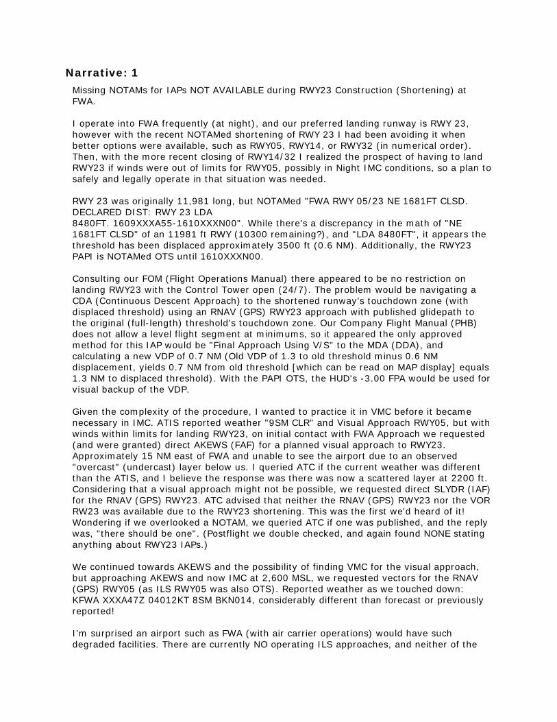
Narrative: 1 Missing NOTAMs for IAPs NOT AVAILABLE during RWY23 Construction (Shortening) at FWA. I operate into FWA frequently (at night), and our preferred landing runway is RWY 23, however with the recent NOTAMed shortening of RWY 23 I had been avoiding it when better options were available, such as RWY05, RWY14, or RWY32 (in numerical order). Then, with the more recent closing of RWY14/32 I realized the prospect of having to land RWY23 if winds were out of limits for RWY05, possibly in Night IMC conditions, so a plan to safely and legally operate in that situation was needed. RWY 23 was originally 11,981 long, but NOTAMed "FWA RWY 05/23 NE 1681FT CLSD. DECLARED DIST: RWY 23 LDA 8480FT. 1609XXXA55-1610XXXN00". While there's a discrepancy in the math of "NE 1681FT CLSD" of an 11981 ft RWY (10300 remaining?), and "LDA 8480FT", it appears the threshold has been displaced approximately 3500 ft (0.6 NM). Additionally, the RWY23 PAPI is NOTAMed OTS until 1610XXXN00. Consulting our FOM (Flight Operations Manual) there appeared to be no restriction on landing RWY23 with the Control Tower open (24/7). The problem would be navigating a CDA (Continuous Descent Approach) to the shortened runway's touchdown zone (with displaced threshold) using an RNAV (GPS) RWY23 approach with published glidepath to the original (full-length) threshold's touchdown zone. Our Company Flight Manual (PHB) does not allow a level flight segment at minimums, so it appeared the only approved method for this IAP would be "Final Approach Using V/S" to the MDA (DDA), and calculating a new VDP of 0.7 NM (Old VDP of 1.3 to old threshold minus 0.6 NM displacement, yields 0.7 NM from old threshold [which can be read on MAP display] equals 1.3 NM to displaced threshold). With the PAPI OTS, the HUD's -3.00 FPA would be used for visual backup of the VDP. Given the complexity of the procedure, I wanted to practice it in VMC before it became necessary in IMC. ATIS reported weather "9SM CLR" and Visual Approach RWY05, but with winds within limits for landing RWY23, on initial contact with FWA Approach we requested (and were granted) direct AKEWS (FAF) for a planned visual approach to RWY23. Approximately 15 NM east of FWA and unable to see the airport due to an observed "overcast" (undercast) layer below us. I queried ATC if the current weather was different than the ATIS, and I believe the response was there was now a scattered layer at 2200 ft. Considering that a visual approach might not be possible, we requested direct SLYDR (IAF) for the RNAV (GPS) RWY23. ATC advised that neither the RNAV (GPS) RWY23 nor the VOR RW23 was available due to the RWY23 shortening. This was the first we'd heard of it! Wondering if we overlooked a NOTAM, we queried ATC if one was published, and the reply was, "there should be one". (Postflight we double checked, and again found NONE stating anything about RWY23 IAPs.) We continued towards AKEWS and the possibility of finding VMC for the visual approach, but approaching AKEWS and now IMC at 2,600 MSL, we requested vectors for the RNAV (GPS) RWY05 (as ILS RWY05 was also OTS). Reported weather as we touched down: KFWA XXXA47Z 04012KT 8SM BKN014, considerably different than forecast or previously reported! I'm surprised an airport such as FWA (with air carrier operations) would have such degraded facilities. There are currently NO operating ILS approaches, and neither of the

two runways (5 and 23) have any sort of VGSI (VASI or PAPI). With the RWY23 shortening lasting over a month, wouldn't some sort of temporary VGSI (PLASI?) be appropriate? I'm also concerned that NO NOTAMs for RWY23 IAPs have made it into our company's flight planning system, if such NOTAMs even exist. I've contacted our company "Duty Officer" who will forward my concerns to our Flight Safety department. I'm told they will look into issuing a "Company NOTAM" and query FWA ATC regarding the missing NOTAMs for RWY23 IAPs. For reference, the KFWA Weather and NOTAMs ----------------------- OBSERVATIONS ----------------------- KFWA XXXB54Z 01004KT 10SM SCT120 BKN250 23/18 A3006 RMK AO2 SLP176 T02330183 = KFWA XXXA54Z 01007KT 10SM BKN120 BKN250 25/19 A3005 RMK AO2 SLP172 T02500189 = ------------------------- FORECAST ------------------------- TAF AMD KFWA XXXC39Z 2400/2424 02006KT P6SM SCT100 BKN200 FMXXXG00 05006KT P6SM BKN020 FMXXXL00 06006KT P6SM OVC015 TEMPO XXXM/XXXO 4SM BR OVC008 FMXXXR 08008KT P6SM BKN025 = -------------------------- NOTAMS -------------------------- LIDO Chart NOTAMs ----------------- LIDO Chart NOTAMs have been retired To request Jeppesen Chart Change Notices for any airport or FIR use http://www.jetplan.com/weather/html/text/CCNAdHocForm.shtml Domestic NOTAMs --------------- FWA 09/072 FWA RWY 32 PAPI OUT OF SERVICE FWA 09/071 FWA RWY 14/32 CLSD FWA 09/055 FWA RWY 32 ALS OUT OF SERVICE FWA 09/025 FWA RWY 23 HLDG PSN SIGN S SIDE NOT LGTD FWA 09/024 FWA RWY 05 HLDG PSN SIGN S SIDE NOT LGTD FWA 09/023 FWA RWY 05 HLDG PSN SIGN N SIDE NOT LGTD FWA 09/022 FWA RWY 05/23 NE 1681FT CLSD. DECLARED DIST: RWY 05 TORA 8480FT TODA 8480FT ASDA 8480FT LDA 8480FT. RWY 23 TORA 8480FT TODA 8480FT ASDA 8480FT LDA 8480FT. FWA 09/018 FWA RWY 32 HLDG PSN SIGN W SIDE FOR RWY 05/23 NOT LGTD FWA 09/015 FWA RWY 14 HLDG PSN SIGN W SIDE FOR RWY 05/23 NOT LGTD

FWA 09/016 FWA RWY 14 HLDG PSN SIGN NE SIDE FOR RWY 05/23 NOT LGTD FWA 09/011 FWA RWY 23 DECLARED DIST: TORA 8480FT TODA 8480FT ASDA 8480FT LDA 8480FT. FWA 09/012 FWA RWY 05 DECLARED DIST: TORA 8480FT TODA 8480FT ASDA 8480FT LDA 8480FT. FWA 09/010 FWA RWY 05 RTZL OUT OF SERVICE FWA 09/009 FWA RWY 05/23 RCLL OUT OF SERVICE FWA 08/143 FWA RWY 23 PAPI OUT OF SERVICE FWA 08/117 FWA RWY 14 PAPI OUT OF SERVICE FWA 09/100 FWA TWY Y5 HLDG PSN SIGN FOR RWY 14/32 NOT LGTD FWA 09/099 FWA TWY Y5 CLSD FWA 09/096 FWA TWY M CLSD FWA 09/095 FWA TWY C1 CLSD FWA 09/093 FWA TWY C HLDG PSN SIGN SOUTHEAST SIDE BTN RWY 14/32 AND TWY Y NOT LGTD FWA 09/092 FWA TWY C HLDG PSN SIGN WEST SIDE BTN RWY 14/32 AND TWY G NOT LGTD FWA 09/090 FWA TWY G4 HLDG PSN SIGN FOR RWY 14/32 WEST SIDE NOT LGTD FWA 09/089 FWA TWY Y4 HLDG PSN SIGN WEST SIDE FOR RWY 14/32 NOT LGTD FWA 09/088 FWA TWY Y4 HLDG PSN SIGN EAST SIDE FOR RWY 14/32 NOT LGTD FWA 09/087 FWA TWY Y HLDG PSN SIGN SOUTHEAST SIDE FOR RWY 05/23 NOT LGTD FWA 09/084 FWA TWY D CLSD FWA 09/081 FWA TWY Y BTN TWY Y1 AND TWY Y3 CLSD FWA 09/080 FWA TWY C BTN TWY G AND RWY 14/32 CLSD FWA 09/077 FWA TWY Y1, Y2, Y3 CLSD FWA 09/034 FWA TWY S CLSD LGTD AND BARRICADED FWA 09/020 FWA TWY C1 HLDG PSN SIGN FOR RWY 05/23 NOT LGTD FWA 09/014 FWA TWY Y HLDG PSN SIGN WEST SIDE FOR RWY 05/23 NOT LGTD FWA 09/013 FWA TWY Y HLDG PSN SIGN EAST SIDE FOR RW Y 05/23 NOT LGTD FWA 09/005 FWA TWY C HLDG PSN SIGN EAST SIDE FOR RWY 14/32 LGT OUT OF SERVICE FWA 09/004 FWA TWY M HLDG PSN SIGN FOR APCH END RWY 23 NOT LGTD FWA 08/168 FWA TWY Y EDGE MARKINGS BTN TWY Y4 AND NORTH RAMP NOT STD FWA 08/165 FWA TWY Y CL MARKINGS FOR RWY 05/23 NOT STD FWA 08/145 FWA TWY G DIRECTION SIGN BTN TWY K AND TWY G4 NOT STD FWA 08/144 FWA TWY G4 TWY DIRECTION SIGN NOT STD FWA 09/073 FWA AD AP WINDCONE FOR RWY 32 LGT OUT OF SERVICE

FWA 09/074 FWA AD AP WINDCONE FOR RWY 14 LGT OUT OF SERVICE
FWA 09/003 FWA AD AP WINDCONE FOR RWY 23 LGT OUT OF SERVICE
FWA 08/130 FWA OBST RIG (ASN UNKNOWN) 405927N0851140W (0.4NM SE APCH END RWY 14) 881FT (75FT AGL) FLAGGED AND LGTD
FWA 08/063 FWA OBST CRANE (ASN UNKNOWN) 410004N0851148W (1.37NM N FWA) 934FT (140FT AGL) FLAGGED THU FRI SAT MON TUE WED XA00-XJ00
FWA 09/054 FWA NAV ILS RWY 32 OUT OF SERVICE FWA 08/133 FWA NAV ILS RWY 05 OUT OF SERVICE FWA 09/032 FWA NAV VOT OUT OF SERVICE -PERM FWA 10/040 FWA NAV ILS RWY 32 OM DECOMMISSIONED -PERM FWA 09/109 FWA SVC TAR/SSR OUT OF SERVICE FDC NOTAMs ---------- NONE
Military NOTAMs --------------- NONE
Local NOTAMs ------------ NONE
Company NOTAMs -------------- NONE ------------------------------------------------------------
Additionally, here is KFWA weather before and after our arrival:
KFWA XXXG54Z 05011KT 10SM OVC016 21/18 A3012 RMK AO2 SLP193 T02110183 KFWA XXXG28Z 04010KT 9SM BKN016 21/18 A3012 RMK AO2 T02110183
KFWA XXXF54Z 05009KT 8SM BKN014 21/18 A3012 RMK AO2 SLP192 T02110183 53014 KFWA XXXF47Z 04012KT 8SM BKN014 21/19 A3011 RMK AO2 T02110189
KFWA XXXE54Z 03011KT 9SM CLR 22/19 A3010 RMK AO2 SLP186 T02220194 KFWA XXXD54Z 35004KT 10SM CLR 22/18 A3008 RMK AO2 SLP182 T02220183 KFWA XXXC54Z 36004KT 10SM FEW140 SCT250 22/18 A3007 RMK AO2 SLP180 T02220183 10306 20222 53009 KFWA XXXB54Z 01004KT 10SM SCT120 BKN250 23/18 A3006 RMK AO2 SLP176 T02330183
Synopsis Air Carrier Captain reported that during construction a FWA, with Runways 14/32 closed and the first 1681 feet of Runway 23 closed, the RNAV (GPS) may not be suitable for some operators due to the requirement for a continuous descent approach and the displaced threshold.
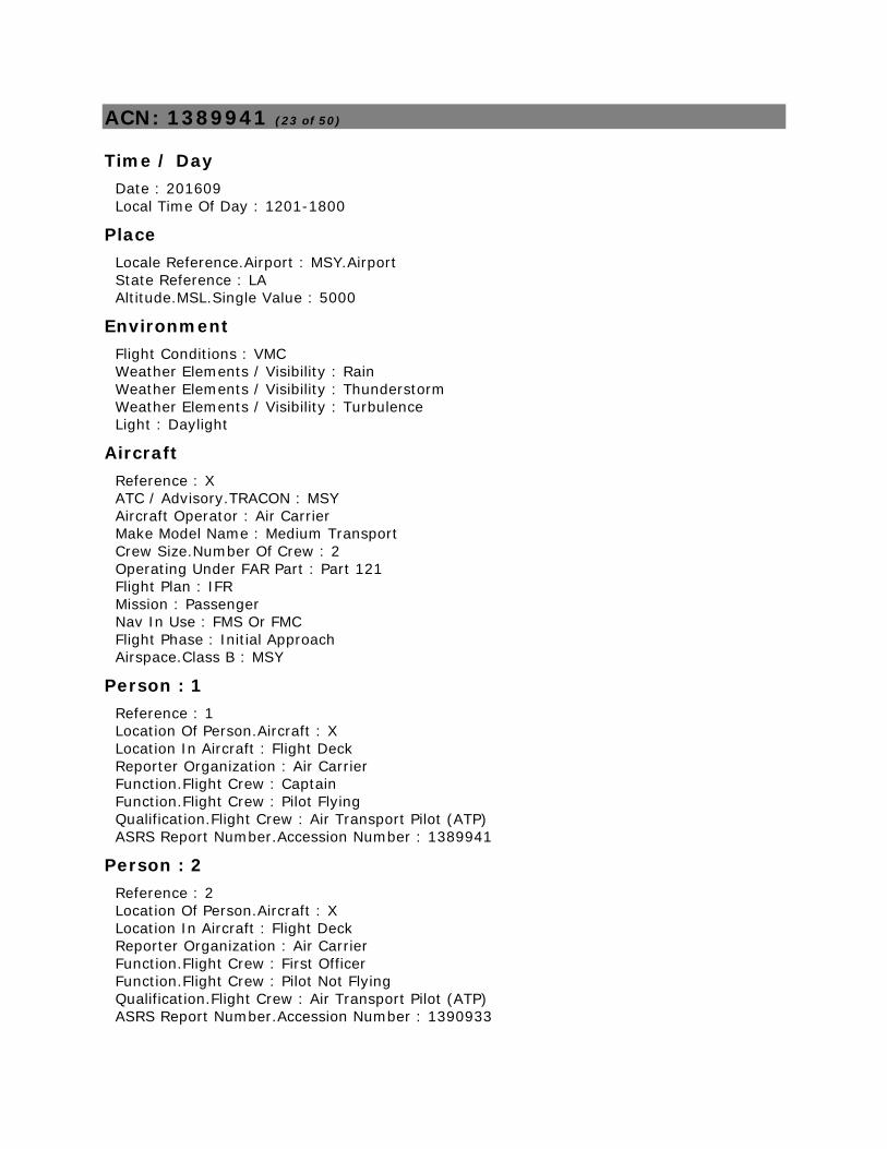
ACN: 1389941 (23 of 50)
Time / Day Date : 201609 Local Time Of Day : 1201-1800
Place Locale Reference.Airport : MSY.Airport State Reference : LA Altitude.MSL.Single Value : 5000
Environment Flight Conditions : VMC Weather Elements / Visibility : Rain Weather Elements / Visibility : Thunderstorm Weather Elements / Visibility : Turbulence Light : Daylight
Aircraft Reference : X ATC / Advisory.TRACON : MSY Aircraft Operator : Air Carrier Make Model Name : Medium Transport Crew Size.Number Of Crew : 2 Operating Under FAR Part : Part 121 Flight Plan : IFR Mission : Passenger Nav In Use : FMS Or FMC Flight Phase : Initial Approach Airspace.Class B : MSY
Person : 1 Reference : 1 Location Of Person.Aircraft : X Location In Aircraft : Flight Deck Reporter Organization : Air Carrier Function.Flight Crew : Captain Function.Flight Crew : Pilot Flying Qualification.Flight Crew : Air Transport Pilot (ATP) ASRS Report Number.Accession Number : 1389941
Person : 2 Reference : 2 Location Of Person.Aircraft : X Location In Aircraft : Flight Deck Reporter Organization : Air Carrier Function.Flight Crew : First Officer Function.Flight Crew : Pilot Not Flying Qualification.Flight Crew : Air Transport Pilot (ATP) ASRS Report Number.Accession Number : 1390933

Events Anomaly.Inflight Event / Encounter : Weather / Turbulence Anomaly.Inflight Event / Encounter : Fuel Issue Detector.Person : Flight Crew When Detected : In-flight
Assessments Contributing Factors / Situations : Weather Primary Problem : Weather
Narrative: 1 I was acting as Pilot In Command and Pilot Flying of a flight to New Orleans, LA (MSY). During this flight we abandoned our approach due to weather and declared minimum fuel. The First Officer set up the FMS as normal while I reviewed the release. I then reviewed the FMS double checked that everything was correct. I [reviewed] the ATIS in New Orleans and noted that at the time, we would expect a visual approach to runway 2, and I loaded the ILS for that runway. We then received our clearance and reviewed the FMS again to ensure everything was correct. Our clearance was correctly loaded in the FMS. I then preformed the brief with the First Officer and ran the Before Start Checklist. We confirmed our fuel on board was 8,600 LBS which matched the release. We then set the weight and balance and handed out the paperwork. After push back, we started the number 2 engine and ran the taxi checklist before calling ramp for taxi. We did not experience any delays on our taxi and as we made the turn from runway XX onto taxiway Echo, I called for the Delay Before Start Checklist as we were number 3 in line for departure. The First Officer started the number 1 engine and I updated our fuel on board, which was around 8,450 LBS, on the PERF page of the FMS. That is when I first noticed that the FMS said that our landing fuel was 2,400 LBS. The reserve fuel for this flight was about 2,350 LBS. At this point, we turned onto E2 and held short of runway XY. I called dispatch to discuss the fuel load with the dispatcher and we both agreed to return for more fuel. The First Officer called ops to request a fuel truck meet us in the west hard stand, while I called ground to request a taxi. Once there, we ran the shutdown checklist and I then informed the Flight Attendants and made a PA announcement. When the truck arrived, I asked for 9,000 LBS total fuel on board which the FMS computed would give about 3,200 LBS on landing. Once done with fueling, we ran the before start checklist, started both engines since there were no other planes waiting for takeoff, ran the taxi checklist and taxied out for takeoff with no delays. Out of 10,000 feet, we accelerated to 280 knots as per the departure, and then 290 knots as per the profile when normal speed was given. During our climb, I again reviewed our fuel as well as the winds aloft. Based on the winds aloft in the release and the ACARS ECON page, the First Officer and I discussed and decided to request a climb from FL360, our filed altitude, to FL380. Once at FL380, I checked the fuel again and determined that increasing our speed to M.82 would give us a landing fuel of 3,100 LBS and allow us to make up several minutes since we were only about 15 minutes late at that point. Somewhere close to ATL, we were cleared direct to the SJI VOR and we noticed some build ups in the distance. Using the radar, we could see they were about 150 NM out and we discussed which way to go around them. We only needed 10 degrees right and once

passed we turned back towards SJI. About 40 minutes from New Orleans, I briefed the approach, with the ATIS still reporting a visual approach to runway 2. Houston Center held us up high for a while, not giving us a descent until west of Mobile and we made an idle descent from FL380 to 11,000 feet. As we made our descent, the approach controller stated that the airport and turned around and to expect a visual to runway 20. We then set up for the RNAV approach and I briefed it. Because we had been held high for so long, I asked for a delay vector to lose some more altitude and we were vectored to the north before turning back just outside of RAYOP on the RNAV 20 approach. We were given a 180 heading to join the approach between RAYOP and JASPO and to contact the tower. We checked in with the tower and were cleared to land runway 20, and advised that there was a Microburst Alert for runway 11 with a loss of 25 knots. The controller called the winds as 210 at 15 gusting to 25. At this time, I looked at our fuel again and we had about 3,200 LBS on board. We continued on the approach for a few seconds longer as I analyzed the situation. We were in VMC and I had the airport in sight at about 1,800 feet just inside of JASPO. I could also see a rain shaft with what appeared to be heavy rain just to the west of the field. I knew we did not have an Alternate, nor did we have any missed approach fuel or holding fuel and any delays in a decision could lead to a fuel emergency. I decided to execute a missed approach with a turn to the east. We asked how fast and what direction the cell was moving. The controller said was not moving very much and that it was sitting pretty much on top of the field. I looked the station bulletin and determined that Baton Rouge was the closest airport at 56 NM and decided to divert there and declared Minimum Fuel. The First Officer entered direct Baton Rouge and loaded an approach while we were given a vector over Lake Pontchartrain towards Baton Rouge and a climb to 10,000 feet. I confirmed the change in the FMS and then looked at the fuel, which said we would land with 1,400 LBS of fuel. I realized that heading to Baton Rouge would not work, and stopped the climb at 5,000 feet. I asked again what the weather was in New Orleans. The controller said the winds were 190 at 7 gusting to 15 and that there was another arrival that said there was no loss or gain in speed. I decided to turn back to New Orleans to land. We then reloaded the RNAV runway 20 and flew the visual approach. I added 5 knots to the REF speed and called for the continuous ignition. We did not experience any gain or loss of speed on the approach and landed with about 2,700 LBS of fuel on board. The TAF for our scheduled time of arrival was 140/7knots P6SM SCT035. There was no inclement weather forecasted in New Orleans for the entire day. When we sent for the ATIS, they were not reporting any adverse weather and we did not expect any. The cell popped up just prior to our arrival.
Narrative: 2 The original flight release indicated -VFR- forecast weather at the destination airport, with no significant weather en-route. The release indicated no ALT or HOLD fuel, with a minimal amount of fuel for tanker (1,000 lbs). We taxied for [departure]. When we were number 2 in sequence for departure, both the Captain and I noticed a "Check Fuel at Destination" message on the FMS. I suggested asking the tower controller for clearance to taxi into the taxiway so we could have adequate time to discuss the problem. Looking at the reserve fuel, we would have landed only 70 lbs. above that planned reserve. We elected to return to the ramp for more fuel.

We received additional fuel, with 9,000 lbs FOB at departure (Flight plan RAMP FOB was 8,687 lbs/Takeoff 7314 lbs). This delay set us back about 55 minutes. The en-route phase was uneventful. We made a small deviation of 40 nm between a cluster of air mass thunderstorms on either side of our flight planned route. Fuel burn was on schedule, with our numbers at each checkpoint around 100 lbs. above the planned burn. The arrival into New Orleans required small lateral deviations for build-ups. While on a base vector for the RNAV GPS Y to Runway 20, a large cell on the radar with red/magenta shading, properly attenuated, displayed just to the southwest edge of the airport. Visual confirmation of the cell out the window confirmed its severity. Notable strong downdrafts with heavy precipitation made the likelihood of severe shear/microburst potential high - no outflow from the downdrafts with precipitation was visible. We had been cleared for the approach at this point and just switched to the tower frequency. The controller almost immediately issued a microburst alert. The Captain and I both agreed performing missed approach was the safest course of action, and the approach was aborted. We asked for a left turn away from the severe thunderstorm. The controller issued a 090 heading with a climb to 3,000 ft. and handed us back to the approach controller. I advised the flight attendants of what had happened and that we would communicate the next step in the plan with them shortly. We were given a climb to 10,000 ft. and vectored over Lake Pontchatrain while we developed a plan - the Captain elected to stop the climb at 5,000 ft. The Captain wanted to proceed directly to Baton Rouge as an alternate airport. I programmed that into the FMS while advising Approach of our intentions. After programming Baton Rouge into the FMS, it indicated that we would land just at, or slightly below reserve fuel. I then decided to program in the likely approach we would receive, to get a more accurate idea of the fuel. It had our planned landing fuel at around 1,400 lbs. Having seen this, The Captain declared "Minimum Fuel" to the controller. The Captain and I both agreed, given the unknown variables in this dynamic situation, this number wasn't acceptable and made proceeding to Baton Rouge not the best course of action. We considered a second approach to New Orleans. I queried the approach controller if anyone had landed after us in New Orleans and asked for reported conditions. Three other aircraft had made safe approaches and noted minimal changes in wind direction or velocity, then reported at 260/10 gusting to 25 knots. A decision was made to attempt a second approach to New Orleans. I notified the flight attendants of our plan and asked them to remain seated until we were on the ground. We were vectored without delay for another approach, the RNAV Y to Runway 20 and subsequently were cleared for the approach. While on the final approach, I advised the tower that I wanted to be notified immediately of any significant changes in wind velocity or direction while on the approach and he agreed to do so. The wind maintained its relative direction and velocity of between 240-260/10-12 knots and gusting to 25 knots throughout the approach. The Captain flew a stabilized approach to a safe landing and we taxied to the gate uneventfully. We landed right at our required legal reserve. I felt the lack of contingency fuel for "real life" line issues, like unforecast air mass thunderstorms at the destination, is what painted us into a corner in this situation. It was concerning to me that departing ABOVE the flight planned ramp and takeoff fuel, we found ourselves in a situation where a lack of fuel jeopardized the safest course of action to divert to an airport without severe weather conditions threatening safe arrival. I had
checked the radar on my iPad for en-route and destination thunderstorms prior to -push back- and had seen nothing indicating a need for additional fuel and upon discussion, the Captain also noted nothing significant when he had looked himself. Landing with any less than 3,000 lbs FOB at destination sets us up for these unnecessary and stressful events. Rerunning the event in my mind, had the airport closed for an accident, or any other reason at the same time we elected to go missed and had to fly to Baton Rouge, the low fuel outcome and nature of the event would have been similar. I can't think of any decision made differently by either the Captain or myself that could have prevented this event from occurring.
Synopsis Regional Jet flight crew reported declaring minimum fuel after abandoning an approach to MSY due to a microburst alert and successfully landed on the second attempt.

ACN: 1389737 (24 of 50)
Time / Day Date : 201609 Local Time Of Day : 0601-1200
Place Locale Reference.Airport : BOI.Airport State Reference : ID
Environment Light : Daylight
Aircraft Reference : X ATC / Advisory.TRACON : BOI Aircraft Operator : Air Carrier Make Model Name : Medium Transport, High Wing, 2 Turboprop Eng Crew Size.Number Of Crew : 2 Operating Under FAR Part : Part 121 Flight Plan : IFR Mission : Passenger Nav In Use : FMS Or FMC Nav In Use : GPS Flight Phase : Initial Approach Route In Use.STAR : KYAAN2 Route In Use.Other Airspace.Class C : BOI
Person Reference : 1 Location Of Person.Aircraft : X Location In Aircraft : Flight Deck Reporter Organization : Air Carrier Function.Flight Crew : Captain Function.Flight Crew : Pilot Flying Qualification.Flight Crew : Air Transport Pilot (ATP) ASRS Report Number.Accession Number : 1389737 Human Factors : Situational Awareness
Events Detector.Person : Flight Crew When Detected : In-flight Result.Flight Crew : Executed Go Around / Missed Approach Result.Flight Crew : Became Reoriented
Assessments Contributing Factors / Situations : Human Factors Primary Problem : Human Factors
Narrative: 1

During cruise, I was preparing for the arrival into Boise, landing west. I was looking for an approach that would connect with the KYAAN 2 arrival. I wanted to do an RNAV approach, and the RNP X Rwy 28R was the only one that connected from the KYAAN 2. [At the departure airport], as I always do, I had circled the approaches on the paperwork that were out of service. Unfortunately, later when I was choosing an approach, I didn't remember that. The first indication that something was not right, was an FMS message that said something was not correct about the next leg. I looked closer at the FMS, and everything looked correct, but then reaching that next fix, we got the EGPWS 'CAUTION TERRAIN' and the FGC lost its VNAV and we went into PITCH mode. We performed a missed approach. While being vectored for the ILS, a light went off in my head, and I checked the weather packet, where I realized our mistake of attempting an OTS approach. Maybe there is no better way to handle these OTS approaches, but I did what I was supposed to do [during preflight] as far as reviewing the destination info. After this incident, I decided to start the practice of highlighting OTS approaches at the destination airport in Jepp Pro while reviewing the weather packet. I also will include a note about the OTS approaches on the 'Landing' side of the data card. That should prevent this sort of mistake from happening again, but if an approach is OTS for long periods of time, why are they listed in our Jeppesen subscription and even in the FMS? This seems like all the holes in the cheese are being lined up by the company with the only means of catching this, being the actions of the pilots. Granted, the corrective measures I stated above will come in handy for many other situations, such as when an approach is only OTS for a short period of time, such as hours or days. Those corrective measures should prevent this from happening again. Cause of the event was that I forgot that I earlier had made note of the fact that a particular approach contained in both our Jepps and FMS, was and has been out of service for many months. When I read this information at the departure airport, I did not write down this restriction in a place that would remind me later.
Synopsis Air carrier Captain reported using an out of service approach into BOI which resulted in an EGPWS "CAUTION TERRAIN" alert.

ACN: 1389034 (25 of 50)
Time / Day Date : 201609 Local Time Of Day : 1201-1800
Place Locale Reference.Airport : HIO.Airport State Reference : OR Altitude.MSL.Single Value : 500
Environment Flight Conditions : VMC Light : Daylight
Aircraft : 1 Reference : X ATC / Advisory.Tower : HIO Aircraft Operator : Corporate Make Model Name : Medium Large Transport Crew Size.Number Of Crew : 2 Operating Under FAR Part : Part 91 Flight Plan : IFR Mission : Passenger Flight Phase : Final Approach Route In Use.Other Airspace.Class D : HIO
Aircraft : 2 Reference : Y ATC / Advisory.Tower : HIO Aircraft Operator : Personal Make Model Name : Cessna Single Piston Undifferentiated or Other Model Crew Size.Number Of Crew : 1 Operating Under FAR Part : Part 91 Flight Plan : VFR Mission : Training Flight Phase : Final Approach Airspace.Class D : HIO
Person : 1 Reference : 1 Location Of Person.Facility : HIO.Tower Reporter Organization : Government Function.Air Traffic Control : Local Function.Air Traffic Control : Supervisor / CIC Qualification.Air Traffic Control : Fully Certified Experience.Air Traffic Control.Time Certified In Pos 1 (yrs) : 7.0 ASRS Report Number.Accession Number : 1389034 Human Factors : Situational Awareness

Human Factors : Workload Human Factors : Distraction
Person : 2 Reference : 2 Location Of Person.Aircraft : X Location In Aircraft : Flight Deck Reporter Organization : Corporate Function.Flight Crew : Captain Function.Flight Crew : Pilot Flying Qualification.Flight Crew : Air Transport Pilot (ATP) Qualification.Flight Crew : Instrument Qualification.Flight Crew : Multiengine Experience.Flight Crew.Total : 7700 Experience.Flight Crew.Last 90 Days : 122 Experience.Flight Crew.Type : 2178 ASRS Report Number.Accession Number : 1391296 Human Factors : Situational Awareness
Person : 3 Reference : 3 Location Of Person : Gate / Ramp / Line Reporter Organization : FBO Function.Flight Crew : Instructor Qualification.Flight Crew : Flight Instructor Qualification.Flight Crew : Commercial ASRS Report Number.Accession Number : 1389285 Human Factors : Situational Awareness Human Factors : Confusion Human Factors : Training / Qualification
Events Anomaly.ATC Issue : All Types Anomaly.Conflict : Airborne Conflict Anomaly.Deviation - Track / Heading : All Types Anomaly.Deviation - Procedural : Published Material / Policy Anomaly.Deviation - Procedural : Clearance Detector.Automation : Aircraft RA Detector.Person : Flight Crew Detector.Person : Air Traffic Control When Detected : In-flight Result.Flight Crew : Took Evasive Action Result.Flight Crew : Requested ATC Assistance / Clarification Result.Flight Crew : Executed Go Around / Missed Approach Result.Flight Crew : Became Reoriented Result.Air Traffic Control : Issued Advisory / Alert Result.Air Traffic Control : Separated Traffic Result.Air Traffic Control : Issued New Clearance
Assessments Contributing Factors / Situations : Human Factors Contributing Factors / Situations : Procedure

Contributing Factors / Situations : Staffing Primary Problem : Staffing
Narrative: 1 I was working Controller in Charge combined with Local Control. I had 3 fixed wing Cessnas and 2 helicopters. One Cessna was a full stop and I just picked up the third Cessna, a student solo on first solo in the pattern, aircraft Y. I was somewhat distracted due to being tasked with a random alcohol testing. The phone was ringing almost non-stop with calls from the air traffic manager, union rep, maintenance control coordinating for equipment outages.
I had issued aircraft Y a sequence and clearance to follow and pilot read back correctly all instructions. I turned my back to answer a call and as I hung up the other local controller stated "overshoot". I immediately turned to see that my Cessna cleared for Runway 31R was on approximately 1/4 mile final for Runway 31L and a business jet, aircraft X was right behind him. I immediately issued a go around for aircraft Y, but as I was doing that aircraft X pilot stated "there is a Cessna in front of us" and stated he was initiating a go-around. I immediately told aircraft Y to stop his climb, that there was a jet behind him climbing out over the top, and to remain low. I stated "stay low, stay low, stay low." Aircraft Y complied and the Local Controller told aircraft X to go around to the left and got instructions from Portland approach. After recovering, I told aircraft Y to fly right traffic and told him he had lined up on the wrong runway. I then made all aircraft under my control full stop. Shortly thereafter, I was relieved on local 2.
We have recently had multiple issued with aircraft lining up on the wrong runway, overshooting final or drifting off the departure end into the parallel runway. I am unsure at this point about my recommendation, but do think something needs to be done. Whether or not it's on the air traffic side or the flight school side or both will be determined.
Narrative: 2 While cleared to land Runway 31L on the RNAV 31L at HIO, in visual conditions, the crew saw a small Cessna cut in front of their final approach path when we were at roughly 500 feet AGL. Our TCAS was on and operating properly, but never alerted us to the other aircraft. Once we saw the aircraft directly in front of us, we initiated a go around, and alerted the Tower. The controller told us to offset to the left in our go around. We complied, and were soon handed off to Portland Approach. We were vectored for the RNAV 31L and landed without incident.
After speaking with the HIO Tower Manager, it was determined that this was a foreign student pilot who was cleared to land on Runway 31R and somehow got confused and while on his right base leg to 31R, instead turned final for Runway 31L.
Narrative: 3 Student pilot on first solo was cleared to land on Runway 31R following traffic on the right downwind for Runway 31L ahead of him. Traffic landed on Runway 31L and student followed the traffic. Business jet was on final and had to go around. Student also executed a go around and did a right traffic pattern for Runway 31R full stop.
Synopsis A Local Controller reported not noticing a student pilot line up to land on the wrong parallel runway. The aircraft cut in front of a corporate jet aircraft on short final who initiated a go around on their own.

ACN: 1388732 (26 of 50)
Time / Day Date : 201609 Local Time Of Day : 1201-1800
Place Locale Reference.ATC Facility : GSP.TRACON State Reference : SC Altitude.MSL.Single Value : 6000
Environment Flight Conditions : IMC Light : Daylight
Aircraft Reference : X ATC / Advisory.TRACON : GSP Aircraft Operator : Personal Make Model Name : King Air C90 E90 Crew Size.Number Of Crew : 1 Operating Under FAR Part : Part 91 Flight Plan : IFR Mission : Personal Flight Phase : Descent Route In Use : Direct Airspace.Class E : GSP
Person Reference : 1 Location Of Person.Aircraft : X Location In Aircraft : Flight Deck Reporter Organization : Personal Function.Flight Crew : Pilot Flying Function.Flight Crew : Single Pilot Qualification.Flight Crew : Flight Instructor Qualification.Flight Crew : Commercial Qualification.Flight Crew : Multiengine Qualification.Flight Crew : Instrument Experience.Flight Crew.Total : 6000 Experience.Flight Crew.Last 90 Days : 100 Experience.Flight Crew.Type : 20 ASRS Report Number.Accession Number : 1388732 Human Factors : Communication Breakdown Communication Breakdown.Party1 : Flight Crew Communication Breakdown.Party2 : ATC
Events Anomaly.Deviation - Altitude : Excursion From Assigned Altitude Anomaly.Deviation - Procedural : Clearance Anomaly.Inflight Event / Encounter : CFTT / CFIT

Detector.Person : Air Traffic Control When Detected : In-flight Result.Flight Crew : Returned To Clearance Result.Flight Crew : Became Reoriented Result.Air Traffic Control : Issued New Clearance
Assessments Contributing Factors / Situations : Human Factors Primary Problem : Human Factors
Narrative: 1 Descending en-route to CEU. Previous altitude clearance had been descend and maintain 7000 feet. Next clearance was copied as "cleared direct TUZKO and the RNAV (GPS) RWY 7 Approach". Descent was initiated. Upon reaching 6000 feet ATC advised that clearance to maintain 7000 feet was still in effect and that I should climb immediately for terrain avoidance. Upon reaching 7000 feet I asked ATC to repeat my last clearance. ATC read "cleared direct TUZKO for the RNAV (GPS) RWY 7 Approach". With communication difficulties I understood and read back cleared for the approach. Being approximately 10 NM from TUZKO, I intended to cross TUZKO at 4700 feet as published. The root cause can be described as miscommunication. The importance of using standard phraseology cannot be overstated. Possibly changes in communication protocols should be considered including exact read backs and restating altitude clearances.
Synopsis B90L Pilot reported receiving a terrain warning and a climb clearance from ATC after he misunderstood his clearance and descended early.

ACN: 1388029 (27 of 50)
Time / Day Date : 201609 Local Time Of Day : 1801-2400
Place Locale Reference.Airport : DEN.Airport State Reference : CO
Aircraft Reference : X ATC / Advisory.TRACON : D01 Aircraft Operator : Air Carrier Make Model Name : B737-800 Crew Size.Number Of Crew : 2 Operating Under FAR Part : Part 121 Flight Plan : IFR Nav In Use : FMS Or FMC Flight Phase : Descent Airspace.Class E : D01
Person Reference : 1 Location Of Person.Aircraft : X Location In Aircraft : Flight Deck Reporter Organization : Air Carrier Function.Flight Crew : Pilot Not Flying Function.Flight Crew : Captain Qualification.Flight Crew : Air Transport Pilot (ATP) ASRS Report Number.Accession Number : 1388029 Human Factors : Workload Human Factors : Time Pressure
Events Anomaly.ATC Issue : All Types Anomaly.Deviation - Procedural : Published Material / Policy Detector.Person : Flight Crew When Detected : In-flight Result.General : None Reported / Taken
Assessments Contributing Factors / Situations : Human Factors Contributing Factors / Situations : Procedure Primary Problem : Procedure
Narrative: 1 This [report is concerning] a problem (and I think a known problem) with Denver's arrivals and mating them up with a runway to which they are not built or made to go together. This narrative may be specific to the B737 fleet and it's FMC.

First we were assigned three different arrivals in a short period of time and the DEN STARs are not simple affairs. Finally we are assigned the ZPLYN THREE RNAV Arrival, an arrival for south runways, even though the ATIS says they are landing north. First difficulty in getting the FMC [programmed]. We were cleared the ZPLYN THREE RNAV Arrival and to descend via. While I MAKE the box work with the south Runway STAR and the north runway it is time consuming and fraught with errors of typing in points and crossing altitudes. Then we are handed over to approach and given a new runway, 16L. So into the box, FMC again select the STAR, select the Runway, select the Transition. Boom - it won't take it because QWIKE is AT 1100 feet the IAF KIPPR for 16L is A MANDATORY 12000 feet Altitude Constraint Error. To make it work I can remove one of the altitudes - but which one? Yes, by the way, this is probably going to be a VFR affair, but we are to back it up with IFR procedures and in the case of the STAR we are clear on it and descend via it so we are stuck with that. OK.... so forget the tradition that causes the problem and the FMC will accept the Runway. But, if you do that you do not get 3 points on the approach, KIKME one prior to the FAF, then the FAF and one more. Well let's see, how many aircraft are out there, I don't know..... Will they be turning us in outside the KIKME? Well it is back to the FMC to enter some more approach point that don't get put in without a Transition. A Transition that is not built to align with the assigned runway therefore it will not be accepted the FMC. More typing manual inputting points and crossing altitude restrictions. All this is happening with my First Officer (FO) who is very good, but the FO is not the most experienced I fly with and the next time, or sometime soon, when I fly this I could be with a new hire FO. The FO is flying, I am "managing the FMC", I am not able to do a very good job at pilot monitoring. What's this new thing were are supposed to say, "I am feeling very much in the yellow approaching RED as far as comfort level." I finally get the FMC squared away as we are given descent past the STAR and am very distracted and my FO is just trying to keep up with what I am doing while he is flying. I was in the Yellow for way too long on what should have been a simple descent on VFR conditions to a VFR approach - backed up with the ILS (or whatever instrument approach is available, or all available aids) as taught. All this is in a VFR environment and maybe that is why ATC thinks all is well. Well, if ATC is planning to just wing it VFR, then don't put us on a STAR with DESCEND VIA clearance to a runway that will not mate with the assigned STAR. If DEN plans to use a Runway that does not mate with a STAR then inform ATC to give, maybe a DESCEND VIA EXCEPT... descend to the appropriate altitude for the expected
runway, or an altitude AT OR ABOVE all transition IAFs. There is too much confusion with DEN STARs and there alignment with only specific RUNWAYs and then APPROACH assigning RUNWAYS that do not fit/mate/align with the assigned STAR. This is not a ONE OFF event at DEN. If you fly into DEN often enough you get used to the 'WAY THEY DO BUSINESS", but aren't we all supposed to be able do it as it was designed and to be done and expect things to be the same at one airports as another in regards to selecting the STAR and then the RUNWAY and then the TRANSITION and it work as advertised, without having the know each airport's idiosyncrasies?
Synopsis B737-800 Captain reported the FMC workload on DEN arrivals is often excessively high, and complicated by multiple runway changes and procedure irregularities.

ACN: 1388005 (28 of 50)
Time / Day Date : 201609 Local Time Of Day : 1201-1800
Place Locale Reference.ATC Facility : ZAU.ARTCC State Reference : IL
Environment Flight Conditions : VMC Light : Daylight
Aircraft Reference : X ATC / Advisory.Center : ZAU Make Model Name : Cessna Citation Sovereign (C680) Crew Size.Number Of Crew : 2 Operating Under FAR Part : Part 135 Flight Plan : IFR Mission : Passenger Nav In Use : FMS Or FMC Flight Phase : Descent Route In Use.STAR : FISSK4 Airspace.Class A : ZAU
Component Aircraft Component : FMS/FMC Aircraft Reference : X Problem : Design
Person Reference : 1 Location Of Person.Aircraft : X Location In Aircraft : Flight Deck Function.Flight Crew : Pilot Flying Function.Flight Crew : Captain Qualification.Flight Crew : Air Transport Pilot (ATP) ASRS Report Number.Accession Number : 1388005 Human Factors : Situational Awareness
Events Anomaly.Aircraft Equipment Problem : Less Severe Anomaly.Deviation - Track / Heading : All Types Anomaly.Deviation - Procedural : Clearance Detector.Person : Flight Crew Detector.Person : Air Traffic Control When Detected : In-flight

Result.Flight Crew : Became Reoriented Result.Air Traffic Control : Issued Advisory / Alert
Assessments Contributing Factors / Situations : Aircraft Contributing Factors / Situations : Human Factors Primary Problem : Ambiguous
Narrative: 1 Shortly after checking on to frequency on the FISSK FOUR RNAV arrival into MDW we heard the end of an exchange with ATC about a waypoint being a fly by vs fly over waypoint. This put me on a slightly higher alert for the arrival. The SIC was busy programming the FMS for the expected runway. I noticed the course from TROLY to GOTNE disappeared from the MFD screen and the airplane began a slow early turn to intercept a course from GOTNE to FISSK. We were also on a descent clearance to make a lower crossing restriction. I wasn't at that moment sure if we had caused the error during FMS programming or not. I immediately asked ATC if they needed me over GOTNE or not because the plane was either making a very early smart turn or dumping the arrival. ATC issued a new clearance and reestablished us on the arrival. He queried if we thought there was a coding issue with the arrival or our error. We advised we were still working that out for certain. ATC said that he was hearing that we were not the first aircraft to have that issue. After a review we could not find any reason for the malfunction. I believe the coding for this portion of the arrival needs to be reviewed. The only other possibility that I did not check and subsequently changed planes is the default flight config page. Though I feel certain that there is some type of coding error on this leg in the database there are two other possible contributing possibilities to consider. 1. This flight occurred on the day of chart revision page change over. While I don't think this actual arrival was due to change maybe some other route that also uses this segment has changed. 2. I have seen an increase in the number of airplanes that the default flight config has been changed to 7 vs 15 degrees of bank. This does cause aircraft to turn shallower enroute. This effect is most amplified as the turn approaches 90 degrees. The flight config can be changed by flight crew but I have experienced a few instances where the avionics defaults to 7 degrees after a power cycle. I did not think to check this on the affected airplane. Many times the aircraft lose the last settings for things like flight director preferences after a full shut down or a temporary but slightly longer than normal red "x" on FMS 1 after power up etc. This may cause flight config to also reset to 7 degrees of bank which according to the Honeywell manual is the default. We may need to add this to the after start check if it's found to be common.
Synopsis CE-680 Captain reported a track deviation resulted from either a miscoded arrival or the aircraft's "smart turn" characteristics.

ACN: 1387698 (29 of 50)
Time / Day Date : 201609 Local Time Of Day : 1801-2400
Place Locale Reference.Airport : MRY.Airport State Reference : CA Altitude.MSL.Single Value : 1250
Environment Flight Conditions : VMC Weather Elements / Visibility : Haze / Smoke Light : Dusk
Aircraft Reference : X ATC / Advisory.Tower : MRY Aircraft Operator : Fractional Make Model Name : Light Transport, Low Wing, 2 Turbojet Eng Crew Size.Number Of Crew : 2 Operating Under FAR Part : Part 91 Flight Plan : IFR Mission : Ferry Nav In Use : FMS Or FMC Flight Phase : Final Approach Route In Use.Other Airspace.Class C : MRY
Person : 1 Reference : 1 Location Of Person.Aircraft : X Location In Aircraft : Flight Deck Reporter Organization : Fractional Function.Flight Crew : Captain Function.Flight Crew : Pilot Flying Qualification.Flight Crew : Air Transport Pilot (ATP) ASRS Report Number.Accession Number : 1387698
Person : 2 Reference : 2 Location Of Person.Aircraft : X Location In Aircraft : Flight Deck Reporter Organization : Fractional Function.Flight Crew : First Officer Function.Flight Crew : Pilot Not Flying Qualification.Flight Crew : Air Transport Pilot (ATP) ASRS Report Number.Accession Number : 1387696
Events

Anomaly.Deviation - Procedural : Published Material / Policy Anomaly.Deviation - Procedural : Clearance Anomaly.Inflight Event / Encounter : CFTT / CFIT Detector.Person : Flight Crew When Detected : In-flight Result.Flight Crew : Took Evasive Action Result.Flight Crew : FLC complied w / Automation / Advisory
Assessments Contributing Factors / Situations : Human Factors Primary Problem : Human Factors
Narrative: 1 EGPWS Event: On the RNAV-Y 28L into MRY in VMC conditions. The airport itself reported 10 miles and clear and then 10 miles and 900 SCT. The approach occurred during dusk/sun setting. We originally planned and briefed the visual approach with the LOC/DME 28L back-up by utilizing the FMS. The LOC 28L was NOTAMed INOP. Upon approaching WIGGL, the IAF for both approaches, ATC informed us that we need to choose an actual approach as the airport WX has changed to 10 miles in smoke and 900 OVR. We asked for the only other approach available to us the RNAV-Y 28L and decided to forgo a thorough briefing and fly it with the PM guiding the PF. Unfortunately, we missed the step down fixes between the FAF and the MAP that were not represented in the FMS. There was slight confusion as to the application of the step down fixes i.e. applies to only the LP minimums or also the LNAV minimums. I decided to descend to the MDA as early as possible as to allow for more time to search for the runway in the haze. During the level off at the MDA, 1200 FT, about 6 NM from the runway and descending through about 1250 FT, we received first a EGPWS TERRAIN Caution followed immediately with EGPWS TERRAIN Warning. We immediately initiated the escape maneuver. As we were still in VMC conditions and some distance from the runway i.e. we were still able to remain within the "stable criteria", we elected to level off at about 1500-1600FT upon being clear of the EGPWS Caution, as well as, Warning area, no audio messages, and no colors depicted on the terrain map and continued with the descent so as to level off at the MDA about 3 NM from the runway. At that point we saw the runway and continued with an uneventful approach and landing.
Narrative: 2 [Report narrative contained no additional information.]
Synopsis Corporate jet flight crew reported that during the RNAV-Y 28L approach to MRY they descended to the MDA early which triggered an EGPWS TERRAIN warning. They initiated the escape maneuver and were able to reestablish the approach to a successful landing.

ACN: 1387670 (30 of 50)
Time / Day Date : 201609 Local Time Of Day : 0001-0600
Place Locale Reference.Airport : ILM.Airport State Reference : NC
Environment Flight Conditions : Marginal Weather Elements / Visibility : Rain Light : Daylight
Aircraft Reference : X ATC / Advisory.Tower : ILM Aircraft Operator : Air Carrier Make Model Name : Regional Jet CL65, Undifferentiated or Other Model Crew Size.Number Of Crew : 2 Operating Under FAR Part : Part 121 Flight Plan : IFR Mission : Passenger Nav In Use : FMS Or FMC Nav In Use : GPS Flight Phase : Final Approach Route In Use.Other Airspace.Class E : ILM
Person : 1 Reference : 1 Location Of Person.Aircraft : X Location In Aircraft : Flight Deck Reporter Organization : Air Carrier Function.Flight Crew : Captain Function.Flight Crew : Pilot Not Flying Qualification.Flight Crew : Air Transport Pilot (ATP) ASRS Report Number.Accession Number : 1387670 Human Factors : Situational Awareness Analyst Callback : Attempted
Person : 2 Reference : 2 Location Of Person.Aircraft : X Location In Aircraft : Flight Deck Reporter Organization : Air Carrier Function.Flight Crew : First Officer Function.Flight Crew : Pilot Flying Qualification.Flight Crew : Air Transport Pilot (ATP)

ASRS Report Number.Accession Number : 1387672 Human Factors : Situational Awareness
Events Anomaly.Deviation - Procedural : Published Material / Policy Anomaly.Inflight Event / Encounter : CFTT / CFIT Detector.Automation : Aircraft Terrain Warning When Detected : In-flight Result.Flight Crew : Executed Go Around / Missed Approach
Assessments Contributing Factors / Situations : Chart Or Publication Contributing Factors / Situations : Human Factors Primary Problem : Ambiguous
Narrative: 1 During descent via the RNAV 6 approach prior to MDA we received EGPWS "caution obstacle" followed by "obstacle obstacle" and "pull up pull up" warning. We were VMC at that moment with rain showers obscuring the field. No visual obstacles were noted; missed approach/go around procedures were implemented. Flight attendants were notified and we were re-vectored to ILS 6 for a normal approach and landing. Upon further review of the charts, we noted that on the RNAV 6 the highest obstacle on the approach path is 250 feet with the MDA of 500 feet while on the identical approach path for the ILS Y LOC/DME has a 450 foot obstacle and an additional stepdown fix ZIPVO of 580 feet prior to the final MDA of 420 feet. If the 450 foot tower is actually there then it should be charted on all the charts, and if so the intermediate stepdown fix ZIPVO of 580 feet should be there for other non-precision approaches. If the tower isn't there, there may [be] an error in the EGPWS database.
Narrative: 2 It is my opinion that 500 MSL is too low of an altitude for the MDA on this particular approach or an additional stepdown fix needs to be created or that an erroneous aural warning occurred. Although I saw no obstacle outside the front airplane window during the aural messages it was noted by the Captain after shutdown that ILS Y Runway 6 depicts a 450 foot MSL obstacle in the vicinity of our location during the event.
Synopsis Air carrier flight crew reported executing a go-around after receiving an EGPWS obstacle warning on the RNAV 6 approach to ILM. Reporter stated the obstacle is not charted on the RNAV 6 approach.

ACN: 1387280 (31 of 50)
Time / Day Date : 201609 Local Time Of Day : 0601-1200
Place Locale Reference.Airport : MEM.Airport State Reference : TN Altitude.MSL.Single Value : 8800
Environment Flight Conditions : VMC Light : Daylight Ceiling : CLR
Aircraft : 1 Reference : X ATC / Advisory.TRACON : M03 Aircraft Operator : Air Carrier Make Model Name : Regional Jet 200 ER/LR (CRJ200) Crew Size.Number Of Crew : 2 Operating Under FAR Part : Part 121 Flight Plan : IFR Mission : Passenger Nav In Use : FMS Or FMC Flight Phase : Initial Approach Route In Use.STAR : BLUZZ1 Airspace.Class B : MEM
Aircraft : 2 Reference : Y ATC / Advisory.TRACON : M03 Aircraft Operator : Air Carrier Make Model Name : Widebody Transport Crew Size.Number Of Crew : 2 Operating Under FAR Part : Part 121 Flight Plan : IFR Mission : Cargo / Freight Nav In Use : FMS Or FMC Flight Phase : Initial Approach Route In Use.STAR : BLUZZ1 Airspace.Class B : MEM
Person Reference : 1 Location Of Person.Aircraft : X Location In Aircraft : Flight Deck Reporter Organization : Air Carrier Function.Flight Crew : Pilot Not Flying Function.Flight Crew : Captain

Qualification.Flight Crew : Air Transport Pilot (ATP) ASRS Report Number.Accession Number : 1387280 Analyst Callback : Completed
Events Anomaly.Inflight Event / Encounter : Wake Vortex Encounter Anomaly.Inflight Event / Encounter : Loss Of Aircraft Control Detector.Person : Flight Crew Were Passengers Involved In Event : Y When Detected : In-flight Result.Flight Crew : Took Evasive Action Result.Flight Crew : Regained Aircraft Control Result.Air Traffic Control : Issued New Clearance
Assessments Contributing Factors / Situations : Procedure Contributing Factors / Situations : Environment - Non Weather Related Primary Problem : Procedure
Narrative: 1 While in the approach phase of flight on the BLUZZ1 RNAV arrival into MEM, ATC advised us we were 5 miles in trail of a heavy. While descending near CLARK at 8800 ft and 210 KIAS, we encountered moderate/severe wake turbulence associated with the [wide body transport] and a light left quartering headwind. Our aircraft abruptly rolled right approximately 45-60 degrees, autopilot disconnected and stall warbler was activated. I immediately took the controls, regained control of the aircraft, applied full thrust, and initiated a climbing right turn to approximately 10,000 ft. I immediately advised ATC I was recovering from the wake turbulence and in a climbing right turn to avoid further encounters. ATC gave us a turn to offset the course of the [wide body transport] and a descent to remain above the preceding aircraft. Once stable, I called the flight attendant to make sure she and all passengers were unharmed. We remained above the path of the [wide body transport] for the duration of the flight and landed with no further instances. [Suggest] greater distance for heavy in trail aircraft.
Callback: 1 Reporter had no additional information.
Synopsis CRJ-200 Captain reported encountering moderate to severe wake turbulence in trail of a widebody transport on arrival into MEM.
ACN: 1387242 (32 of 50)
Time / Day Date : 201609 Local Time Of Day : 0601-1200
Place Locale Reference.Airport : DEN.Airport State Reference : CO Altitude.MSL.Single Value : 11000
Environment Flight Conditions : VMC Light : Daylight
Aircraft Reference : X ATC / Advisory.TRACON : D01 Aircraft Operator : Air Carrier Make Model Name : A320 Crew Size.Number Of Crew : 2 Operating Under FAR Part : Part 121 Flight Plan : IFR Mission : Passenger Nav In Use : FMS Or FMC Nav In Use : GPS Flight Phase : Initial Approach Route In Use.Other Airspace.Class B : DEN
Person Reference : 1 Location Of Person.Aircraft : X Location In Aircraft : Flight Deck Reporter Organization : Air Carrier Function.Flight Crew : Captain Function.Flight Crew : Pilot Not Flying Qualification.Flight Crew : Air Transport Pilot (ATP) ASRS Report Number.Accession Number : 1387242 Human Factors : Situational Awareness
Events Anomaly.Deviation - Procedural : Published Material / Policy Anomaly.Deviation - Procedural : FAR Detector.Person : Flight Crew When Detected : In-flight Result.Flight Crew : Became Reoriented
Assessments

Contributing Factors / Situations : Aircraft Contributing Factors / Situations : Human Factors Contributing Factors / Situations : Procedure Primary Problem : Human Factors
Narrative: 1 Day before Day 3 we flew 2 legs, with an early east coast wake up and report time. What was supposed to be an easy day tuned into a very long day with multiple delays adding about 4 hours of duty time to our day. Day 3 Departed ZZZ on time. Early AM once again. Visual conditions prevailed at the time of our arrival into Denver approach's airspace. We were told to expect either the ILS 35R or possibly the RNAV RNP Z. We briefed the ILS. I believe somewhere in the descent from 14,000 to 11,000 ft we were given the clearance for the RNAV RNP Z. Being that the prevailing visibility was VFR, I PM/CA gave an abbreviated briefing. I briefed the PF/FO from the EFB checklist. However, I failed to pick up the paper covering the RNAV placard to see that the a/c was not RNAV/RNP approved. It wasn't listed in the remarks section or in the crew briefing of the release. I didn't catch the error until after the approach had been initiated. We continued in VFR conditions and landed with visual conditions uneventfully. Had it been IFR, I wouldn't have done an abbreviated briefing. Suggestions 1) To be more vigilant. 2) I would like to see some changes with our procedures. Specifically, I would like to see a "monthly" memo of which aircraft are not RNP/AR certified. With the non-standard fleet and aircraft continuously coming and going, it is hard to remember which item applies to which aircraft. Some aircraft in the fleet are not RNP/AR approved, but lack a placard. In speaking with Maintenance, I was told a placard was not a required item. 3) Have dispatch continue to state in remarks and crew briefing sections of release, that RNAV/RNP not authorized, even though aircraft has been on property awhile; not only when it's new to the line. 4) Move placard to glareshield in direct view of both pilots. 5) Place placard or sticker on logbook stating such (just like overwater aircraft). 6) Make RNAV RNP Not authorized sticker red, not black and white, so it catches your attention. The Pilot memos only go back so far in my EFB. In searching for information, I could find [only two aircraft] with memos. I feel at times that we are set up for failure. I pride myself on being thorough. It is not my intention to place blame elsewhere, but to draw attention to how easily these simple fixes could help mitigate future error.
Synopsis A320 Captain reported accepting an approach for which the aircraft was not approved. The approach and landing were without incident due to clear weather.

ACN: 1387031 (33 of 50)
Time / Day Date : 201609 Local Time Of Day : 1801-2400
Place Locale Reference.Airport : ZZZZ.Airport State Reference : FO Altitude.MSL.Single Value : 1700
Environment Flight Conditions : VMC
Aircraft Reference : X ATC / Advisory.Tower : ZZZZ Aircraft Operator : Air Carrier Make Model Name : A319 Crew Size.Number Of Crew : 2 Operating Under FAR Part : Part 121 Flight Plan : IFR Mission : Passenger Flight Phase : Initial Approach
Component Aircraft Component : Flap/Slat Control System Aircraft Reference : X Problem : Malfunctioning
Person : 1 Reference : 1 Location Of Person.Aircraft : X Location In Aircraft : Flight Deck Reporter Organization : Air Carrier Function.Flight Crew : Captain Function.Flight Crew : Pilot Flying Qualification.Flight Crew : Air Transport Pilot (ATP) ASRS Report Number.Accession Number : 1387031
Person : 2 Reference : 2 Location Of Person.Aircraft : X Location In Aircraft : Flight Deck Reporter Organization : Air Carrier Function.Flight Crew : First Officer Function.Flight Crew : Pilot Not Flying Qualification.Flight Crew : Air Transport Pilot (ATP) ASRS Report Number.Accession Number : 1387028
Events

Anomaly.Aircraft Equipment Problem : Less Severe Anomaly.Deviation - Procedural : Published Material / Policy Detector.Person : Flight Crew When Detected : In-flight Result.Flight Crew : Overcame Equipment Problem
Assessments Contributing Factors / Situations : Aircraft Primary Problem : Aircraft
Narrative: 1 RNAV approach to Runway 12 VMC. Normal managed RNAV approach profile flown, planned for flaps full landing configuration. Autopilot was engaged throughout descent until just prior to FAF. Flaps 1 selected at approximately 2,200 speed 210 knots 15 miles out. Aircraft leveled off at initial approach altitude 1,700 feet 9.5 miles out. Selected flaps 2, normal operation. Selected flaps 3, gear down 3 miles from FAF, level at 1,700 feet, slats fault message appeared on ECAM. Both slat and flap actual position indications matched the correct position indexes on the ECAM display for flaps 3; however both remained amber. No other messages or ECAM action noted. Prior to FAF, elected to update approach performance landing configuration to flaps 3 and not attempt to move flap handle. Final approach descent profile parameters were all normal down to landing. First Officer jiggled flap handle several times on short final, slats fault message disappeared. There was no apparent slat or flap movement indicated or perceived. During taxi back we cycled flaps several times with no faults noted. Discussed condition with maintenance and asked whether any faults were retained or indicated in the Aircraft Integrated Data System (AIDS), none were noted.
Narrative: 2 Aircraft was established on final approach segment of the RNAV GNSS Runway 12. Just prior to the final approach fix, the aircraft was configured flaps 2, gear down. The pilot flying called for flaps 3, landing checklist. I moved flap handle to the flap 3 position and immediately received an ECAM status message F/CTL SLATS FAULT/LOCKED. It appeared that the slats and flaps had stopped moving somewhere between the flap 2 and flap 3 configuration. After a brief discussion, we elected to continue the approach. Since the aircraft was established on a stable descent profile in VMC conditions to a dry runway with calm winds, it did not appear prudent to attempt a go-around and reconfigure the aircraft with an apparent slat/flap fault. We had initial planned on a full flap landing, and the pilot flying asked me to reset the landing data for a flaps 3 landing. After resetting the information, I cleared the F/CTL SLATS FAULT/LOCKED message from the ECAM and ran the landing checklist. It was at that point that we noticed the slat/flap indication on the ECAM was showing both slats and flaps in the 3 position, but in an amber, meaning that the slats/flaps were not in the correct position. At about 300 feet the GPWS began sounding an aural "Too Low, Flaps" warning. At about 100 feet I tried resetting the flap position by pulling up on the flap lever detent unlock. When I did that, the GPWS aural warning ceased and the ECAM slat/flap indicator changed from amber to green. The pilot flying made a normal landing. After taxiing clear of Runway

12 we attempted cycling the slats/flaps several times and could not duplicate the event. After shutdown we spoke with maintenance and asked them to see if they could pull an incident report from the ECAM showing the F/CTL SLATS FAULT/LOCKED. They were unable to find any indication of the message in the ECAM stored reports. It is unclear if the slat/flap system detected an asymmetric or fault condition, or if the slat/flap handle switch did not make proper contact with the handle in the flaps 3 detent position. If faced with a similar scenario with a stable aircraft established on final descent to a dry runway with calm winds in VMC conditions, I would not change our course of action.
Synopsis A319 flight crew reported choosing to continue the approach following an ECAM status message F/CTRL SLATS FAULT/LOCKED.

ACN: 1386643 (34 of 50)
Time / Day Date : 201609 Local Time Of Day : 0001-0600
Place Locale Reference.Airport : DCA.Airport State Reference : DC
Environment Flight Conditions : VMC Light : Dusk
Aircraft Reference : X ATC / Advisory.Tower : DCA Make Model Name : EMB ERJ 190/195 ER/LR Operating Under FAR Part : Part 121 Flight Plan : IFR Mission : Passenger Nav In Use : FMS Or FMC Flight Phase : Initial Approach Route In Use : Visual Approach Airspace.Class B : DCA
Component Aircraft Component : Autoflight System Aircraft Reference : X Problem : Malfunctioning
Person : 1 Reference : 1 Location Of Person.Aircraft : X Location In Aircraft : Flight Deck Reporter Organization : Air Carrier Function.Flight Crew : Captain Function.Flight Crew : Pilot Flying Qualification.Flight Crew : Air Transport Pilot (ATP) ASRS Report Number.Accession Number : 1386643 Human Factors : Situational Awareness
Person : 2 Reference : 2 Location Of Person.Aircraft : X Location In Aircraft : Flight Deck Reporter Organization : Air Carrier Function.Flight Crew : First Officer Function.Flight Crew : Pilot Not Flying

ASRS Report Number.Accession Number : 1387352 Human Factors : Situational Awareness
Events Anomaly.Aircraft Equipment Problem : Less Severe Anomaly.Inflight Event / Encounter : Unstabilized Approach Detector.Person : Flight Crew When Detected : In-flight Result.Flight Crew : Became Reoriented Result.Flight Crew : Executed Go Around / Missed Approach
Assessments Contributing Factors / Situations : Aircraft Contributing Factors / Situations : ATC Equipment / Nav Facility / Buildings Contributing Factors / Situations : Human Factors Primary Problem : Human Factors
Narrative: 1 On the River Visual into DCA we received a VGP [Vertical Glide Path] unavailable message. I monitored the approach with LNAV & PTH engaged, the aircraft became high and wasn't descending enough to keep up with the approach. I turned the automation off, but the aircraft was too high and fast for a stabilized approach so we executed a go around. The same thing happened on the second approach, however we were more prepared and I turned the automation off earlier and hand flew the rest of the approach. I'm not sure why we received the VGP unavailable message. This happened in my training during the FTD and once in the simulator. Neither the instructor nor the Check Airman knew the cause. I figured this was a sim issue and wouldn't be something I would see on the line. Obviously that's not the case, my only guess is that if you get vectored in tight that the aircraft won't allow an intercept in VGP. It was a good learning experience though, I've been able to think about how I would handle the situation again if it occurs again. I've asked a few other Captains about the VGP unavailable and they mentioned they've seen it but don't know why it happens or how to fix it. I think it would be good to have some information available to the E-190 pilots as to why this occurs, and how to prevent it, also alternatives to use in the event that the aircraft is not able to use VGP. Obviously since this is strictly a visual approach (River visual) the alternatives are different than an RNAV or RNP. Or if this is a specific aircraft issue that would be good to know too. Because I've flown this approach before but never had the VGP unavailable message.
Narrative: 2 [Report narrative contained no additional information.]
Synopsis ERJ-190 flight crew reported executing a go-around following an unstabilized RNAV-F approach into DCA when "VGP unavailable" was displayed.

ACN: 1386315 (35 of 50)
Time / Day Date : 201609 Local Time Of Day : 1201-1800
Place Locale Reference.Airport : AFJ.Airport State Reference : PA Altitude.MSL.Single Value : 2000
Aircraft : 1 Reference : X ATC / Advisory.TRACON : PIT Make Model Name : Super King Air 200 Operating Under FAR Part : Part 91 Flight Plan : IFR Flight Phase : Final Approach Airspace.Class E : PIT
Aircraft : 2 Reference : Y ATC / Advisory.TRACON : PIT Make Model Name : Baron 55/Cochise Operating Under FAR Part : Part 91 Flight Plan : IFR Flight Phase : Initial Climb Airspace.Class E : PIT
Person Reference : 1 Location Of Person.Facility : PIT.TRACON Reporter Organization : Government Function.Air Traffic Control : Approach Function.Air Traffic Control : Departure Qualification.Air Traffic Control : Fully Certified Experience.Air Traffic Control.Time Certified In Pos 1 (yrs) : 21 ASRS Report Number.Accession Number : 1386315 Human Factors : Human-Machine Interface Human Factors : Situational Awareness Human Factors : Distraction
Events Anomaly.ATC Issue : All Types Anomaly.Conflict : Airborne Conflict Anomaly.Deviation - Procedural : Clearance Detector.Person : Air Traffic Control When Detected : In-flight Result.Air Traffic Control : Issued Advisory / Alert Result.Air Traffic Control : Separated Traffic

Assessments Contributing Factors / Situations : Human Factors Contributing Factors / Situations : Procedure Primary Problem : Procedure
Narrative: 1 Aircraft X, practicing approaches at AFJ, was cleared for RNAV 27 approach and over to advisory frequency. Aircraft Y, called for departure and I released him, thinking he was departing another PIT satellite airport. Aircraft Y, called off the airport, I did not see him and told him to check transponder on, after a few moments, I asked again, and told him I saw nothing off of BTP airport, he then advised he was off AFJ, I then noticed the situation. In this situation, the error was strictly on controller attention to detail, I misread the strip, and that is simply it. I should not have missed that but I had. Read the strip.
Synopsis PIT TRACON Controller reported of releasing an aircraft off of an airport. The airport was not the one the aircraft was departing. Once airborne the Controller realized his error, realized a loss of separation was occurring, and worked to separate traffic.

ACN: 1384736 (36 of 50)
Time / Day Date : 201609 Local Time Of Day : 1801-2400
Place Locale Reference.ATC Facility : ZDV.ARTCC State Reference : CO Altitude.MSL.Single Value : 17000
Environment Flight Conditions : Marginal Weather Elements / Visibility : Thunderstorm
Aircraft Reference : X ATC / Advisory.Center : ZDV Aircraft Operator : Air Carrier Make Model Name : Bombardier/Canadair Undifferentiated or Other Model Crew Size.Number Of Crew : 2 Operating Under FAR Part : Part 121 Flight Plan : IFR Mission : Passenger Airspace.Class A : ZDV Airspace.Class E : ZDV
Person Reference : 1 Location Of Person.Facility : ZDV.ARTCC Reporter Organization : Government Function.Air Traffic Control : Enroute Qualification.Air Traffic Control : Fully Certified Experience.Air Traffic Control.Time Certified In Pos 1 (yrs) : 20 ASRS Report Number.Accession Number : 1384736 Human Factors : Confusion Human Factors : Situational Awareness Human Factors : Workload Human Factors : Communication Breakdown
Events Anomaly.ATC Issue : All Types Anomaly.Deviation - Track / Heading : All Types Anomaly.Deviation - Procedural : Published Material / Policy Anomaly.Deviation - Procedural : Clearance Anomaly.Inflight Event / Encounter : Weather / Turbulence Detector.Person : Air Traffic Control When Detected : In-flight Result.General : Work Refused Result.General : Release Refused / Aircraft Not Accepted Result.Air Traffic Control : Issued New Clearance

Assessments Contributing Factors / Situations : Airspace Structure Contributing Factors / Situations : Company Policy Contributing Factors / Situations : Human Factors Contributing Factors / Situations : Procedure Contributing Factors / Situations : Weather Primary Problem : Company Policy
Narrative: 1 Thunderstorms were impacting the arrival gate into Denver. We had one large cell in particular of moderate to extreme precipitation that was pushing all the arrivals over LARKS. At some point, Denver Tracon (D01) wanted us to transition to putting these arrivals over POWDR instead, the parallel arrival west of LARKS. I called D01 and verified they wanted this, the reply was "I'd appreciate that" and I told him we still had 4 more arrivals on the wrong side of that cell but will transition to POWDR as soon as possible. The sector feeding us tried to get as many over POWDR as quickly as possible but it just wasn't feasible with the four already over LARKS. I called D01 again to verify the aircraft would be routed "point to point" and not on an RNAV arrival, they agreed. The #3 and #4 aircraft over LARKS, the last two in the LARKS gate, were Aircraft X and Aircraft Y , who were deviating approximately 90 degrees off course for the weather. The R-side worked hard to keep these two separated and sequenced. D01 called and said they couldn't take #4, Aircraft Y , because they couldn't take "side by sides" like we were feeding them. At this time, the #3 and #4 aircraft were 7.2nm in trail, and while we were only under instruction to give 5nm in trail, the parallel POWDR route had 3 aircraft spaced at 20 miles, 14.6 miles, and 15.1 miles between them, not to mention these parallel arrivals were over 24 miles away from the two aircraft east of LARKS - hardly a "side by side" situation and triple to quadruple the spacing they requested. D01 told me that point-out was approved with Aircraft Y , and to turn him west - which was directly back into the weather the aircraft were deviating around. I asked D01 if they really meant for us to turn Aircraft Y into some of the highest depicted weather, he hung up on me. I called again and asked if this was the same controller I had coordinated exactly what I was now feeding them (see above), he said no. I asked if this was a TMC, he said no, he was a supervisor. I then asked to speak to the D01 arrival controller. Things got testy, and he hung up on me without letting me speak to the controller. The R-side told Aircraft Y that D01 would not take him and asked if he could make a left turn, as they requested. He said no and could only go right. He ended up doing a 180 then turning east where he was put into a different stream. This is a recurring problem. Quite often you'll do some coordination with some voice - I say voice because we have no idea who we are talking to - only to be superseded by a different voice. The Traffic Management Coordinators (TMC's) and supervisors at D01 do this on a regular basis. Coordination was already affected in this situation and we were doing exactly what was coordinated. Within minutes, a different person, in this case a supervisor, stepped in and nullified it creating an unsafe and totally unacceptable situation with an airliner who was doing exactly what we told him to do - which was exactly what D01 told us to do. This is not the first time D01 has told us to turn aircraft directly into high level weather, with the main emphasis on "get him out of our airspace" or "keep him in your airspace", which the latter was used in this situation - regardless of the reality and direness of the situation.

We don't know how qualified, or even if certified, on this positions these TMC's and supervisors are. Are they properly briefed and aware of the actual traffic and weather situation? Recent experience says they are not as they appear to jump on the line and make traffic calls that make no sense - or worse, are unsafe. It is unacceptable to agree to a plan, execute that plan, only to be told by someone not even working the position that the plan is null and void. We moved several aircraft around a large cell to make this work. We back-coordinated to set this plan in motion. We can't just be told, at the boundary with weather very close by to just take someone around. Not to mention the "west" they wanted us to go was not only directly into the weather, but also directly toward the parallel stream of arrivals - all of which they already had hand-offs on. This was either gross incompetence, or a set up for a completely unsafe situation vis-a-vis aircraft into weather and aircraft into other aircraft. I asked more than once if this is what the "controller" talking to me wanted, they said yes. Of course the biggest loser in this situation was the user. The D01 supervisor demanded action putting Aircraft Y into an unsafe situation. We are briefed ad nauseam about weather and avoiding precipitation. Presumably D01 displays what we do, do they follow different rules? And this habit of not identifying oneself when we call a particular position has to stop. When I call ARRIVALS, I want ARRIVALS. I don't want a committee of non-controllers with marginal knowledge of the situation anywhere near my coordination. Again, this happens often at Denver Tracon and must end.
Synopsis ZDV Center Controller reported trying to coordinate traffic flows to the D01 TRACON during a period of weather deviations. The Center Controller was receiving conflicting instructions from different people at the TRACON. The Center Controller reports this is an ongoing problem when trying to coordinate with the TRACON.

ACN: 1384506 (37 of 50)
Time / Day Date : 201609 Local Time Of Day : 1201-1800
Place Locale Reference.Airport : GUM.Airport State Reference : GU Altitude.MSL.Single Value : 2500
Environment Flight Conditions : VMC Light : Daylight
Aircraft : 1 Reference : X ATC / Advisory.TRACON : GUM Aircraft Operator : Air Carrier Make Model Name : Widebody, Low Wing, 2 Turbojet Eng Crew Size.Number Of Crew : 2 Operating Under FAR Part : Part 121 Flight Plan : IFR Mission : Passenger Flight Phase : Final Approach Route In Use.Other Airspace.Class E : GUM
Aircraft : 2 Reference : Y ATC / Advisory.TRACON : GUM Aircraft Operator : Military Make Model Name : Military Bomber Crew Size.Number Of Crew : 2 Operating Under FAR Part : Part 91 Mission : Training Flight Phase : Climb Airspace.Class E : GUM
Person : 1 Reference : 1 Location Of Person.Aircraft : X Location In Aircraft : Flight Deck Reporter Organization : Air Carrier Function.Flight Crew : Pilot Flying Function.Flight Crew : Captain Qualification.Flight Crew : Air Transport Pilot (ATP) Experience.Flight Crew.Total : 12627 Experience.Flight Crew.Type : 1463 ASRS Report Number.Accession Number : 1384506

Person : 2 Reference : 2 Location Of Person.Aircraft : X Location In Aircraft : Flight Deck Reporter Organization : Air Carrier Function.Flight Crew : First Officer Function.Flight Crew : Pilot Not Flying Qualification.Flight Crew : Air Transport Pilot (ATP) Experience.Flight Crew.Total : 3941 Experience.Flight Crew.Type : 406 ASRS Report Number.Accession Number : 1384508
Person : 3 Reference : 3 Location Of Person.Facility : ZUA.ARTCC Reporter Organization : Government Function.Air Traffic Control : Approach Qualification.Air Traffic Control : Fully Certified Experience.Air Traffic Control.Time Certified In Pos 1 (yrs) : 1 ASRS Report Number.Accession Number : 1384707 Human Factors : Situational Awareness
Person : 4 Reference : 4 Location Of Person.Facility : GUM.TRACON Reporter Organization : Government Function.Air Traffic Control : Approach Experience.Air Traffic Control.Time Certified In Pos 1 (yrs) : 1 ASRS Report Number.Accession Number : 1384707 Human Factors : Situational Awareness
Events Anomaly.Conflict : Airborne Conflict Detector.Automation : Aircraft RA Detector.Automation : Aircraft TA Detector.Person : Flight Crew Miss Distance.Horizontal : 1500 Miss Distance.Vertical : 200 When Detected : In-flight Result.Flight Crew : Took Evasive Action Result.Flight Crew : FLC complied w / Automation / Advisory
Assessments Contributing Factors / Situations : Airspace Structure Contributing Factors / Situations : Human Factors Contributing Factors / Situations : Procedure Primary Problem : Ambiguous
Narrative: 1 While established on and cleared for the RVAV (RNP) Z Rwy 24R at Guam we receive a very sudden and fast yellow TA traffic alert then about a second later got the red RA alert.

The first officer and I both looked to our right after the yellow TA and there was a military Bomber heading right for us. The yellow TA box showed 2200 feet. We were approximately 2500 feet inside WABOX intersection. After visually acquiring the Bomber first and a second later getting the Red RA with "climb climb", I disconnected the autopilot and started an aggressive climb. After about 200-300 feet the RA stopped. We were clear of traffic. I was stabilized a good distance out and was able to safely descend and reacquire a 3 degree glideslope with the PAPI-L lights insight and make a normal landing Rwy 24R. During the last part of our approach Agana Tower offered us the phone number of the approach control facility located below the tower. The first officer copied it down on taxi in. First officer and I remember hearing approach control clearing an aircraft for what I believe was an "Overhead Break". I think the Bomber came as close as 200 ft and one quarter (1/4) to one third (1/3) mile from us in a very high speed climb. The Bomber could have been closing on us at 250-300 knots.
Narrative: 2 We received an RA at 2500 feet while conducting and RNAV RNP Approach to runway 24R at GUM. The captain was flying and turned off the autopilot and responded to the RA, climbing approximately 200 feet. The RA was in response to a bomber making a sweeping left turn directly into our flight path after crossing over midfield at Andersen Air force base. The bomber was at 2200 feet and appeared to be climbing slightly in the turn. After the RA was concluded we were able to continue the approach and land without incident.
Narrative: 3 Both aircraft were receiving vectors for parallel approach courses into our two airports on Guam (GUM and UAM). Both airports were using Runways 24 Left and Right. The final approach courses parallel approximately 2.5 miles apart. Aircraft X was issued clearance for an RNAV Approach over the IAF WABOX, straight-in to Runway 24R at GUM. Aircraft Y had reported the field in sight for a Visual Approach to Runway 24R to UAM with an overhead pattern. I had vectored Aircraft Y approximately 15 miles behind Aircraft X before turning him inbound because of a large speed difference. The aircraft appeared to be deconflicted under expectation of a reasonable speed profile, so both aircraft were cleared and switched to tower frequencies. I was unaware at the time, but the compression on final continued to the point of a loss of separation. Anderson (UAM) Tower called and asked for control of "area B", which my Radar Assist approved. I did not think it was a conflict so I took no action. The bomber broke left in the overhead at UAM and climbed above pattern altitude for the break, above the confines of Area B, and into the final for Aircraft X causing a TCAS RA. A Mandatory Occurrence Report (MOR) was filed and upon review of the MOR the above previous error was found and brought to my attention. In my opinion the primary cause of the error was my expectation bias of a speed profile for the bomber. I knew he was high and fast but never imagined the aircraft would maintain over 400 knots for so long below 10,000 feet. I should have picked up the discrepancy with my scan and fixed the situation. My recommendation to prevent this type of error is primarily to myself, to continue to scan aircraft even if I firmly believe them to be deconflicted. My secondary recommendation goes to the bomber pilot. Maintaining a grossly excessive speed was unnecessary, difficult to predict, and created a situation that required more of my attention than I had expected.
Narrative: 4

[Report narrative contained no additional information.]
Synopsis Air carrier flight crew experienced a TCAS RA with a bomber aircraft inside WABOX during the RNAV (RNP) Z Runway 24R at GUM. The bomber was performing an overhead break at UAM at high speed and higher than normal traffic pattern altitude. The Controller give his perspective of the event as well.

ACN: 1383468 (38 of 50)
Time / Day Date : 201608 Local Time Of Day : 1801-2400
Place Locale Reference.Airport : SFO.Airport State Reference : CA Altitude.MSL.Single Value : 33000
Environment Flight Conditions : VMC Light : Dusk
Aircraft Reference : X ATC / Advisory.Center : ZOA Aircraft Operator : Air Carrier Make Model Name : EMB ERJ 170/175 ER/LR Crew Size.Number Of Crew : 2 Operating Under FAR Part : Part 121 Flight Plan : IFR Mission : Passenger Nav In Use : FMS Or FMC Nav In Use : GPS Flight Phase : Descent Route In Use.STAR : BDEGA 2 Airspace.Class A : ZOA
Component Aircraft Component : FMS/FMC Aircraft Reference : X Problem : Design
Person Reference : 1 Location Of Person.Aircraft : X Location In Aircraft : Flight Deck Reporter Organization : Air Carrier Function.Flight Crew : Captain Function.Flight Crew : Pilot Not Flying Qualification.Flight Crew : Air Transport Pilot (ATP) ASRS Report Number.Accession Number : 1383468 Human Factors : Situational Awareness
Events Anomaly.Deviation - Altitude : Excursion From Assigned Altitude Anomaly.Deviation - Speed : All Types Anomaly.Deviation - Procedural : Published Material / Policy

Detector.Person : Flight Crew When Detected : In-flight Result.Flight Crew : Returned To Clearance Result.Flight Crew : FLC Overrode Automation
Assessments Contributing Factors / Situations : Aircraft Contributing Factors / Situations : Human Factors Primary Problem : Aircraft
Narrative: 1 On the BDEGA 2 RNAV into SFO, we were given holding instructions to hold at BGGLO as published; we were at FL360; the next controller gave us a descent to FL330. As we approached the holding fix, I, as PM, went off frequency to inform the FA's, PAX and operations of our requirement to hold. I returned just as we were entering the hold. The FMS commanded a 200 knot holding speed. The PF was monitoring the speed and had mentioned to me (earlier as we discussed the procedure to enter the hold) that he thought 200 kts was far too low for the altitude of FL330. As I was returning from coordinating and informing, the airplane was slowing and turning to the holding heading. The PF observed the airspeed at 200 kts, the eyebrows appear (as the aircraft banked) and the low speed tape rise. He interpreted this as an impending stall and kicked off the autopilot. I entered from my coordination's at this point; saw him kick off the auto pilot and commence a descent. I came on the controls to arrest the descent (loss of 300-350 feet), got slightly aggressive about it and the stick shaker activated momentarily (1-2 seconds). We recovered the lost altitude and continued the holding pattern. I don't recall the airspeed ever getting below 200 kts. There was no query from Oakland Center and the rest of the flight was uneventful. I believe the FMS holding speeds are too low for such a high altitude. I don't believe we would have stalled at 200 kts, however. So, my level of confidence was higher than the PF. Even though he expressed his concern, I failed to discern his LEVEL of concern. Also, being "absent" (communicating) at the critical point of entering the hold, removed input that could have mitigated the threat indications; i.e. simply overriding the AT to increase the airspeed during the turn and manually setting a higher hold speed (210-215 kts). Consider increasing canned FMS holding speeds.
Synopsis ERJ-175 Captain reported the FMS was programmed for an unrealistically low airspeed for high altitude holds.

ACN: 1383023 (39 of 50)
Time / Day Date : 201608 Local Time Of Day : 1801-2400
Place Locale Reference.ATC Facility : S56.TRACON State Reference : UT Altitude.MSL.Single Value : 13000
Aircraft Reference : X ATC / Advisory.TRACON : S56 Aircraft Operator : Air Carrier Make Model Name : B737-900 Crew Size.Number Of Crew : 2 Operating Under FAR Part : Part 121 Flight Plan : IFR Nav In Use : FMS Or FMC Flight Phase : Descent Airspace.Class E : S56
Person Reference : 1 Location Of Person.Facility : S56.TRACON Reporter Organization : Government Function.Air Traffic Control : Approach Qualification.Air Traffic Control : Fully Certified Experience.Air Traffic Control.Time Certified In Pos 1 (yrs) : 2 ASRS Report Number.Accession Number : 1383023 Human Factors : Human-Machine Interface Human Factors : Time Pressure Human Factors : Confusion Human Factors : Distraction Human Factors : Communication Breakdown Communication Breakdown.Party1 : ATC Communication Breakdown.Party2 : Flight Crew
Events Anomaly.Airspace Violation : All Types Anomaly.ATC Issue : All Types Anomaly.Deviation - Procedural : Published Material / Policy Anomaly.Deviation - Procedural : Clearance Anomaly.Inflight Event / Encounter : CFTT / CFIT Detector.Automation : Air Traffic Control When Detected : In-flight Result.Flight Crew : Returned To Clearance Result.Air Traffic Control : Provided Assistance Result.Air Traffic Control : Issued New Clearance

Assessments Contributing Factors / Situations : Procedure Contributing Factors / Situations : Human Factors Primary Problem : Procedure
Narrative: 1 Aircraft X was vectored 5 degree left of course and to avoid traffic ahead on his RNAV course. He was told to expect to resume the RNAV and given a "descend and maintain 13,000". When traffic was [no] longer a factor, he was told to "proceed direct QUIPA and resume the arrival". Aircraft X took this as he needed to descend to because we told him to resume the arrival. Aircraft X was in a 127 MVA and descend below the assigned 130. An immediate low altitude alert was issued and the aircraft climbed immediately back to 130. (122 was the lowest observed). Recommend pilots understanding the RNAV procedures better.
Synopsis S56 TRACON reported of an aircraft that descended prematurely causing a low altitude warning. Pilot was advised to climb up to assigned altitude.

ACN: 1382375 (40 of 50)
Time / Day Date : 201608 Local Time Of Day : 0601-1200
Place Locale Reference.Airport : ZZZ.Airport State Reference : US Altitude.AGL.Single Value : 1000
Environment Flight Conditions : VMC Light : Daylight
Aircraft Reference : X ATC / Advisory.Tower : ZZZ Aircraft Operator : Air Carrier Make Model Name : B737-700 Crew Size.Number Of Crew : 2 Operating Under FAR Part : Part 121 Flight Plan : IFR Mission : Passenger Flight Phase : Final Approach Flight Phase : Initial Approach Airspace.Class C : ZZZ
Person : 1 Reference : 1 Location Of Person.Aircraft : X Location In Aircraft : Flight Deck Reporter Organization : Air Carrier Function.Flight Crew : First Officer Function.Flight Crew : Pilot Flying Qualification.Flight Crew : Air Transport Pilot (ATP) ASRS Report Number.Accession Number : 1382375 Human Factors : Time Pressure Human Factors : Workload Human Factors : Distraction Human Factors : Situational Awareness
Person : 2 Reference : 2 Location Of Person.Aircraft : X Location In Aircraft : Flight Deck Reporter Organization : Air Carrier Function.Flight Crew : Captain Function.Flight Crew : Pilot Not Flying Qualification.Flight Crew : Air Transport Pilot (ATP) ASRS Report Number.Accession Number : 1382063

Human Factors : Workload Human Factors : Situational Awareness Human Factors : Fatigue Human Factors : Distraction Human Factors : Time Pressure
Events Anomaly.ATC Issue : All Types Anomaly.Deviation - Track / Heading : All Types Anomaly.Deviation - Procedural : Published Material / Policy Anomaly.Deviation - Procedural : Clearance Detector.Person : Air Traffic Control When Detected : In-flight Result.Flight Crew : Executed Go Around / Missed Approach Result.Flight Crew : Became Reoriented Result.Air Traffic Control : Issued Advisory / Alert
Assessments Contributing Factors / Situations : Airport Contributing Factors / Situations : Human Factors Contributing Factors / Situations : Procedure Primary Problem : Human Factors
Narrative: 1 I was acting as Pilot Flying on our flight. Everything was normal until we began our initial descent. ARTCC had begun descending us much earlier than the RNAV arrival would've. Since we started down early, I felt a slight time compression in getting the brief done and calling for the Descent Checklist. After reviewing the 10-9 and the 10-7, we determined there was nothing urgent that would affect us other than an ACARS outage on the ground at this station. I proceeded to brief the rest of the briefing items and we ran the Descent Checklist. Shortly thereafter we were cleared to cross an arrival waypoint at 11,000 ft, then were vectored on a 140 heading. We switch to HDG SEL and the PM built a course intercept to the FAF. We were then cleared to descend and maintain 2,000 ft and were asked if we had the field in sight approximately 10 NM to the west while descending through 6,000 ft on a left downwind. I told the PM I had it in sight and that he could call it if he saw it, and I called for flaps 1. We were then cleared for the visual approach to Runway XX. A course intercept was built to the FAF. I adjusted the HDG to turn toward the FAF and disconnected the autopilot/auto throttle. I called for and the flaps were set to 5. Approach then asked if we would keep our base and final short and switched us to tower. I immediately called "Gear Down." As I turned base, I visually acquired what I thought was Runway XX and noticed we were high and crossing the extended runway centerline. I increased my rate of turn and continued configuring flaps while the PM selected the requested flap setting, switched to tower and acquired a landing clearance. I called "Flaps 30, Landing Checklist" approaching 1,000 ft AGL. At that time we joined the visual path using the PAPI and I spooled the engines. Shortly thereafter we were advised by the tower that we were "apparently aligned with Runway YX." I immediately initiated a Go Around. We were told to maintain an altitude and heading and switched to departure, who vectored us around for another visual approach to Runway XX. The second approach and landing happened without incident. I was visually aligning myself with what I thought was Runway XX, but which was actually Runway YX. Due to the fact that I was VMC and cleared for the visual but was high, I

focused too much of my attention to managing energy and being stabilized but neglected to check the LOC/GS or the ND to assure my alignment with the proper runway. I also felt pressure from approach which asked if we'd keep our visual approach close in. That is a normal request but since I hadn't mentally prepared for the fact that our visual approach from the west would cross us through the approach path to another runway, I missed an opportunity to trap a threat before it resulted in an undesired aircraft state.
Narrative: 2 I was unfamiliar with airport, we had reviewed 10-9 and 10-7, and thoroughly briefed approach and airport, flight was cleared visual approach to Runway XX. Pilot flying was hand flying and had airport in sight we continued downwind, configured aircraft and were requested by approach control to begin base turn. A bit of a "slam dunk". I got focused on getting down for stabilized approach. Was dividing time between HUD (in IMC mode to utilize "3.0 degree line") and observing outside. I omitted the "heads down" displays from my "scan". ATC instructed us to contact tower on "base" leg, tower was contacted and flight was cleared to land Runway XX, aircraft was configured and stabilized prior to 1000 AGL. I heard tower clearing a Heavy to high speed taxi on Runway YX and noticed an aircraft on our runway, I thought that was odd and was starting to question the approach when tower informed us we appeared to be lined up for Runway YX. I immediately called for go-around. PF initiated a go-around from approximately 1000 AGL. At that point tower cleared us to land on Runway YX, I declined and we continued the go-around. We were assigned a heading and altitude and handed off to approach for vectors for XX. We cleaned up aircraft and almost immediately began process to configure for the visual approach to Runway XX that resulted in an uneventful approach and landing on Runway XX. PM unfamiliar with airport (first time), a bit of a slam dunk visual, PM fixation on stabilized approach and HUD while omitting from my usual scan cues from Flight Displays and FMC led to hampered situational awareness. Early morning reserve callout most likely contributed to some fatigue as well.
Synopsis A B737-NG flight crew reported lining up for the wrong runway on final. The crew felt rushed which caused cognitive tunneling to the exclusion of basic heading and the loss of situational awareness.

ACN: 1382033 (41 of 50)
Time / Day Date : 201608 Local Time Of Day : 1201-1800
Place Locale Reference.Airport : DFW.Airport State Reference : TX Altitude.MSL.Single Value : 23600
Environment Light : Daylight
Aircraft Reference : X ATC / Advisory.Center : ZFW Aircraft Operator : Air Carrier Make Model Name : EMB ERJ 170/175 ER/LR Crew Size.Number Of Crew : 2 Operating Under FAR Part : Part 121 Flight Plan : IFR Mission : Passenger Nav In Use : GPS Nav In Use : FMS Or FMC Flight Phase : Descent Airspace.Class A : ZFW
Component Aircraft Component : MCP Aircraft Reference : X Problem : Malfunctioning
Person Reference : 1 Location Of Person.Aircraft : X Location In Aircraft : Flight Deck Reporter Organization : Air Carrier Function.Flight Crew : First Officer Function.Flight Crew : Pilot Flying Qualification.Flight Crew : Air Transport Pilot (ATP) ASRS Report Number.Accession Number : 1382033
Events Anomaly.Aircraft Equipment Problem : Less Severe Anomaly.Deviation - Altitude : Overshoot Anomaly.Deviation - Altitude : Crossing Restriction Not Met Anomaly.Deviation - Procedural : Published Material / Policy Anomaly.Deviation - Procedural : Clearance Detector.Person : Flight Crew

When Detected : In-flight Result.Flight Crew : Became Reoriented Result.Flight Crew : Returned To Clearance
Assessments Contributing Factors / Situations : Aircraft Contributing Factors / Situations : Human Factors Primary Problem : Ambiguous
Narrative: 1 Cleared to descend via STAR. Set bottom altitude, then selected VNAV. VTA (Vertical Track Alert) captured and first window of FL240. I Noticed that altitude constraint was not captured passing through FL236. We selected alt and reported to ATC. Set automation but continued to monitor through all phases of flight.
Synopsis EMB-170 First Officer reported descending below an altitude constraint during a DFW RNAV Arrival with VNAV selected and the constraint showing in the FMC.

ACN: 1381907 (42 of 50)
Time / Day Date : 201608 Local Time Of Day : 1201-1800
Place Locale Reference.Airport : ATL.Airport State Reference : GA Altitude.MSL.Single Value : 22000
Environment Flight Conditions : Mixed Weather Elements / Visibility : Thunderstorm Light : Daylight
Aircraft Reference : X ATC / Advisory.Center : ZTL Aircraft Operator : Air Carrier Make Model Name : B737 Next Generation Undifferentiated Crew Size.Number Of Crew : 2 Operating Under FAR Part : Part 121 Flight Plan : IFR Mission : Passenger Nav In Use : FMS Or FMC Nav In Use : GPS Flight Phase : Descent Route In Use.STAR : WARRR 1 Airspace.Class A : ZTL
Component Aircraft Component : FMS/FMC Aircraft Reference : X Problem : Design
Person Reference : 1 Location Of Person.Aircraft : X Location In Aircraft : Flight Deck Reporter Organization : Air Carrier Function.Flight Crew : Captain Qualification.Flight Crew : Air Transport Pilot (ATP) Experience.Flight Crew.Last 90 Days : 205 ASRS Report Number.Accession Number : 1381907 Human Factors : Confusion Human Factors : Workload Analyst Callback : Attempted
Events

Anomaly.Aircraft Equipment Problem : Less Severe Anomaly.Deviation - Procedural : Published Material / Policy Detector.Person : Flight Crew When Detected : In-flight Result.Flight Crew : Became Reoriented
Assessments Contributing Factors / Situations : Aircraft Contributing Factors / Situations : Procedure Primary Problem : Aircraft
Narrative: 1 The Nav data in the FMC database for holding southwest as published at LGC on the WARRR 1 Arrival, is different than as depicted on the Jepp chart.
Synopsis A B737-NG Captain reported in August 2016 that the FMC database and the Jeppesen printed chart depict holding on the WARRR 1 RNAV Arrival at LGC VOR differently.

ACN: 1381885 (43 of 50)
Time / Day Date : 201608 Local Time Of Day : 1201-1800
Place Locale Reference.ATC Facility : NCT.TRACON State Reference : CA Altitude.MSL.Single Value : 4000
Environment Flight Conditions : VMC Light : Daylight
Aircraft : 1 Reference : X ATC / Advisory.TRACON : NCT Aircraft Operator : Air Carrier Make Model Name : Medium Transport, Low Wing, 2 Turbojet Eng Crew Size.Number Of Crew : 2 Flight Plan : IFR Flight Phase : Initial Approach Route In Use : Vectors Airspace.Class C : MRY
Aircraft : 2 Reference : Y ATC / Advisory.TRACON : NCT Make Model Name : Light Transport, Low Wing, 2 Turbojet Eng Crew Size.Number Of Crew : 2 Flight Plan : IFR Mission : Passenger Flight Phase : Initial Approach Route In Use : Vectors Airspace.Class C : MRY
Person Reference : 1 Location Of Person.Facility : NCT.TRACON Reporter Organization : Government Function.Air Traffic Control : Instructor Function.Air Traffic Control : Approach Qualification.Air Traffic Control : Fully Certified Experience.Air Traffic Control.Time Certified In Pos 1 (yrs) : 13 ASRS Report Number.Accession Number : 1381885 Human Factors : Distraction Human Factors : Training / Qualification Human Factors : Workload Human Factors : Situational Awareness

Events Anomaly.ATC Issue : All Types Anomaly.Conflict : Airborne Conflict Anomaly.Deviation - Track / Heading : All Types Anomaly.Deviation - Procedural : Clearance Detector.Person : Air Traffic Control When Detected : In-flight Result.Air Traffic Control : Separated Traffic Result.Air Traffic Control : Provided Assistance Result.Air Traffic Control : Issued New Clearance
Assessments Contributing Factors / Situations : Airport Contributing Factors / Situations : Airspace Structure Contributing Factors / Situations : Environment - Non Weather Related Contributing Factors / Situations : Human Factors Contributing Factors / Situations : Procedure Primary Problem : Procedure
Narrative: 1 Training was in progress at the time. The departure sector pointed out an arrival on a right downwind Visual Approach so we knew that aircraft from the north were capable of seeing the field. This weekend was very busy due [to] an event generating 5-8 times the amount of departures and arrivals. To add to the complexity, a TFR was in effect south of MRY. The Runway 28L RNAV Y was the approach in use. Aircraft X and other aircraft were incapable of that approach causing complexity and further burdening the departure sector for opposite direction procedures with consistent departure releases. We offered Aircraft X, Aircraft Y, and a few other aircraft vectors right traffic visual approach to facilitate the arrival flow. Aircraft X was first in line vectored at 4000 feet due to lowest MVA east of MRY and cleared for a Visual Approach. The pilot questioned about a VFR aircraft approximately 3 miles east of the field already talking to the Tower. Aircraft X was on a 3-4 mile right downwind. Aircraft Y was sequenced 6 miles behind at 4000 feet. Aircraft X was on the base leg still at 4000 feet, he was uncertain about the VFR aircraft to his right. I offered Aircraft X to fly south for resequencing and told the pilot to fly heading 180. He read back "roger right turn heading 180", which we didn't catch. The aircraft made a complete 360 degree turn south in conflict with Aircraft Y who was on the right downwind to follow Aircraft X. We had to take immediate evasive actions to turn and climb Aircraft Y out of the way. The biggest issue with MRY, is that the RNAV Y RWY 28L approach does not offer CAT D approaches and the RWY 28L LOC/DME has been out of service for almost 2 years. These issues with the RWY 28L approaches are constantly causing undue delay and complexity to these sectors.
Synopsis NCT TRACON Controller told an aircraft to fly heading 180. The pilot misunderstood the instruction and initiated a 360 degree turn putting it into conflict with traffic behind it on downwind.

ACN: 1381110 (44 of 50)
Time / Day Date : 201608 Local Time Of Day : 0001-0600
Place Locale Reference.Airport : ZZZ.Airport State Reference : US
Environment Flight Conditions : VMC
Aircraft : 1 Reference : X ATC / Advisory.FSS : ZZZ ATC / Advisory.CTAF : ZZZ Aircraft Operator : Air Carrier Make Model Name : Commercial Fixed Wing Crew Size.Number Of Crew : 2 Operating Under FAR Part : Part 121 Mission : Passenger Nav In Use : GPS Nav In Use : FMS Or FMC Flight Phase : Initial Approach Airspace.Class E : ZZZ
Aircraft : 2 Reference : Y ATC / Advisory.FSS : ZZZ ATC / Advisory.CTAF : ZZZ Make Model Name : Helicopter Mission : Tactical Flight Phase : Initial Approach Airspace.Class E : ZZZ
Person Reference : 1 Location Of Person.Aircraft : X Location In Aircraft : Flight Deck Reporter Organization : Air Carrier Function.Flight Crew : First Officer Function.Flight Crew : Pilot Not Flying Qualification.Flight Crew : Air Transport Pilot (ATP) ASRS Report Number.Accession Number : 1381110 Human Factors : Communication Breakdown Human Factors : Distraction Communication Breakdown.Party1 : Flight Crew Communication Breakdown.Party2 : Flight Crew
Events

Anomaly.Conflict : Airborne Conflict Anomaly.Deviation - Procedural : Published Material / Policy Detector.Person : Flight Crew When Detected : In-flight Result.Flight Crew : Executed Go Around / Missed Approach
Assessments Contributing Factors / Situations : Airport Contributing Factors / Situations : Human Factors Primary Problem : Human Factors
Narrative: 1 My first report to [radio] and area traffic on the common traffic advisory frequency was at 25 NM to the north on the RNP RNAV. I gave an accurate ETA, [radio] acknowledged, told us a [military] helicopter was in the traffic pattern. I heard him make a couple of calls on 123.6 as we progressed on our approach. I made a call at 7 miles on final. Didn't get any acknowledgement from helicopter. We broke out of clouds at about 6 miles. At about 3 miles I could visually make out a helicopter sitting (or hovering low) about 1000' down the runway. Then [radio] addressed the helicopter by its call sign with something to the effect of 'There is a [commercial aircraft] on a 3 mile final'. No response. I made a call, 'Air Carrier X on short final', no response. [Radio] asked us to state our intentions just as we were initiating a go-around. The Pilot Flying (PF) offset slightly to the right as we did the go-around because we didn't know what the helicopter would do and wanted more separation. We flew right traffic in VMC and landed normally. All the helicopter said was something to the effect of 'sorry about that'. On downwind I verified with [radio] that [they] heard all of my radio calls.
Synopsis Air Carrier flight crew reported a traffic conflict while trying to land at an uncontrolled airport. The conflict, which resulted in a go-around, was with a helicopter that was not adhering to standard radio procedures.

ACN: 1379697 (45 of 50)
Time / Day Date : 201608 Local Time Of Day : 0601-1200
Place Locale Reference.Airport : LAX.Airport State Reference : CA Altitude.AGL.Single Value : 500
Environment Flight Conditions : VMC Light : Daylight
Aircraft : 1 Reference : X ATC / Advisory.Tower : LAX ATC / Advisory.TRACON : SCT Aircraft Operator : Air Carrier Make Model Name : A320 Crew Size.Number Of Crew : 2 Operating Under FAR Part : Part 121 Flight Plan : IFR Mission : Passenger Flight Phase : Final Approach Route In Use : Visual Approach Route In Use : Vectors Airspace.Class B : LAX
Aircraft : 2 Reference : Y ATC / Advisory.Tower : LAX Aircraft Operator : Air Carrier Make Model Name : B747 Undifferentiated or Other Model Crew Size.Number Of Crew : 2 Operating Under FAR Part : Part 121 Flight Plan : IFR Mission : Passenger Flight Phase : Final Approach Route In Use : Visual Approach Airspace.Class B : LAX
Person Reference : 1 Location Of Person.Aircraft : X Location In Aircraft : Flight Deck Reporter Organization : Air Carrier Function.Flight Crew : First Officer Function.Flight Crew : Pilot Flying Qualification.Flight Crew : Air Transport Pilot (ATP)

Experience.Flight Crew.Total : 6815 Experience.Flight Crew.Last 90 Days : 200 Experience.Flight Crew.Type : 829 ASRS Report Number.Accession Number : 1379697 Human Factors : Situational Awareness Analyst Callback : Attempted
Events Anomaly.ATC Issue : All Types Anomaly.Conflict : Airborne Conflict Anomaly.Inflight Event / Encounter : Wake Vortex Encounter Detector.Person : Flight Crew When Detected : In-flight Result.Flight Crew : Executed Go Around / Missed Approach Result.Air Traffic Control : Issued New Clearance
Assessments Contributing Factors / Situations : Procedure Primary Problem : Procedure
Narrative: 1 On arrival into LAX we were being vectored off of the VISTA2 behind a 747 for a visual approach to 25L. Approach asked if we had the preceding heavy 747 in sight. We acknowledged that we did and were subsequently cleared for the visual approach to 25L, caution wake turbulence. We were on a base leg and the 747 was on final at 12 o'clock and approximately 4 miles so we continued on the base leg to square off the intercept in order to create sufficient clearance for wake turbulence. However a few moments after clearing us for the visual and us taking responsibility for wake turbulence the controller instructed us to turn left 280 for the intercept. We made the turn but were now closer than we felt comfortable and proceeded with plan b for wake avoidance and flew the approach above the 747's approach path. We both noted the quartering tailwind and in spite of descending slightly above profile had intermittent wake encounters. Nothing violent, but better described as light turbulence or dirty air. As we approached the 500 ft gate we felt that the air was too unstable to continue the approach and initiated the go around. Shortly before our decision to go around the controller issued a takeoff clearance to a heavy on 25R. We were climbing out on runway heading while the heavy was climbing out on an RNAV (wind corrected) track. I pointed out the heavy at 1 o'clock and perhaps a quarter to a half mile to the Captain and we agreed that we did not like how this was developing as the crosswind was drifting us towards the heavy. As we were leveling off at 2,000 ft the tower controller issued a left turn to the proceeding heavy which had him turning directly into our path. As the heavy went wing up in the turn the controller gave us a left turn away from the heavy. The controller then switched us over to Approach Control. The Approach Controller climbed us and vectored us around for another visual where we completed an uneventful landing. Several aspects of the approach and the missed bothered both of us; and we both agreed that we are seeing more and more of these occurrences. The first is being cleared for a visual approach and then after being cleared for the visual being issued a vector. While most of the time this results in no harm it does create ambiguity. Because by accepting the visual we are responsible for maneuvering ourselves for a stabilized approach and/or for spacing on the preceding aircraft and yet the controller is chipping away at our intercept that we need for a stabilized visual or worse chipping away at our spacing with

the preceding aircraft - which we are now responsible for. The second issue is launching aircraft on an RNAV departure with an aircraft on a visual approach to the parallel runway. In the event of a go around the aircraft on the visual is flying a heading while the aircraft on departure is on a wind corrected RNAV track. This can create a dangerous situation on its own. The third issue, and perhaps the most dangerous, is issuing a clearance to an aircraft BEFORE issuing a clearance to the aircraft that could be endangered. For example, Ground Control telling a taxiing aircraft that other traffic will give way before telling those aircraft to give way - I hear this constantly. In this instance the preceding heavy was given a turn toward us before we were given a turn to remain clear. It is out of order and could lead to another Tenerife. All it takes is a stuck mic, a blocked transmission, or missed radio call and the chain of events is in motion.
Synopsis A320 First Officer reported executing a go-around after encountering wake turbulence in trail of a B747 on approach to LAX.

ACN: 1378486 (46 of 50)
Time / Day Date : 201608 Local Time Of Day : 1201-1800
Place Locale Reference.Airport : TTPP.Airport State Reference : FO Altitude.MSL.Single Value : 3750
Environment Flight Conditions : Marginal Light : Daylight
Aircraft Reference : X ATC / Advisory.Tower : TTPP Aircraft Operator : Air Carrier Make Model Name : Large Transport, Low Wing, 2 Turbojet Eng Crew Size.Number Of Crew : 2 Operating Under FAR Part : Part 121 Flight Plan : IFR Mission : Passenger Nav In Use : GPS Flight Phase : Initial Approach Route In Use.Other
Person : 1 Reference : 1 Location Of Person.Aircraft : X Location In Aircraft : Flight Deck Reporter Organization : Air Carrier Function.Flight Crew : First Officer Function.Flight Crew : Pilot Not Flying Qualification.Flight Crew : Air Transport Pilot (ATP) ASRS Report Number.Accession Number : 1378486 Human Factors : Confusion Human Factors : Distraction Human Factors : Situational Awareness Human Factors : Workload Human Factors : Communication Breakdown Communication Breakdown.Party1 : Flight Crew Communication Breakdown.Party2 : Flight Crew
Person : 2 Reference : 2 Location Of Person.Aircraft : X Location In Aircraft : Flight Deck Reporter Organization : Air Carrier Function.Flight Crew : Captain
Function.Flight Crew : Pilot Flying Qualification.Flight Crew : Air Transport Pilot (ATP) ASRS Report Number.Accession Number : 1378495 Human Factors : Workload Human Factors : Situational Awareness Human Factors : Confusion Human Factors : Communication Breakdown Human Factors : Distraction Communication Breakdown.Party1 : Flight Crew Communication Breakdown.Party2 : Flight Crew
Events Anomaly.Deviation - Procedural : Published Material / Policy Anomaly.Inflight Event / Encounter : CFTT / CFIT Detector.Automation : Aircraft Terrain Warning Detector.Person : Flight Crew When Detected : In-flight Result.Flight Crew : Became Reoriented Result.Flight Crew : FLC complied w / Automation / Advisory Result.Flight Crew : Returned To Clearance Result.Flight Crew : Took Evasive Action
Assessments Contributing Factors / Situations : Airport Contributing Factors / Situations : Environment - Non Weather Related Contributing Factors / Situations : Human Factors Contributing Factors / Situations : Procedure Contributing Factors / Situations : Weather Primary Problem : Human Factors
Narrative: 1 Flying to TTPP in intermediate IMC conditions. CA acting as PF and FO as PM. Airport conditions indicated a landing to west on RWY 28 with an RNAV approach. There was discussion as to whether they were actually using the west RWY as it was rarely used. CA believed they would be landing RWY 10 with a slight tailwind so we calculated the landing distance with tailwinds to verify distance was adequate for conditions. PF briefed approach landing RWY 10 with the addendum that we would switch to RWY 28 if ATIS stated RWY 28. Upon contacting Piarco Approach verified RWY 28 as landing RWY and rebriefed the approach as they initially cleared us to BOSOT. We requested POS VOR as a fix instead of BOSOT as to remain on the other side of the terrain. There was some confusion as to where center was clearing us to from our position as there were no feeder fixes to reach BOSOT from our position. At this point we accepted SEBAS instead of BOSOT as a fix and entered SEBAS as a waypoint to link to BOSOT. PF rebriefed that we were going to cross over terrain to SEBAS which was 2500 and we had already briefed 4100 ft as MSA. Approximately 25-30 miles from airport at 5000 ft we were cleared direct BOSOT and cleared for the approach. PF selected APPR mode and we verified FINAL APP and V/DEV presentation while descending to 4100 ft to cross terrain and begin approach. CA had weather display up and FO had terrain up on screens. Somewhere before BOSOT, CA set 2500 ft as his next step down altitude for BOSOT. As

not to have too steep of a descent angle toward terrain CA used Vertical speed to shallow his descent and inadvertently descended below the correct altitude. I was communicating with Piarco center and tower controllers and was unaware that he had switched to vertical speed mode. I realized we were too low and stated that we needed to return to MSA of 4100 ft. During this time there was some confusion as to which altitude should have been set, why we lost the protection of 4100 ft as a floor and why we continued descent to 2500 ft pushing us below where we should have been. As CA was starting to correct his descent and climb the terrain warning was activated. CA immediately performed the escape maneuver climbing away from the terrain. At this point we were in VMC conditions with the runway in sight. CA disconnected automation and performed a stabilized VMC approach to land. Flying around terrain is a normal hazard of our operations. While many rules and procedures have been developed to mitigate dangers situational awareness is paramount. As PM I should have been more proactive in monitoring our position, where we were asking the FMS to take us and communicating and verifying what was actually happening. Confusion as how to set up the FMS was allowed to override the attention to critical altitudes and verifying ATC clearance and altitude restrictions. Adherence to strict monitoring of altitudes and our position should have prevented us from ever descending below a safe altitude. Reintegrating where we were in position to the terrain we were crossing and our next safe altitude should have been our most important and clear concern. Clear communication should have been better on my part to prevent this situation.
Narrative: 2 We were expecting the ILS10 approach and I set that up and briefed it. Approaching the airport the ATIS and the approach control said Runway 28 was in use. So I set up and briefed the RNAV28 approach. We were NW of the field descending and deviating around weather and we discussed that this approach takes you over a mountain ridge on arrival. We were cleared direct to "SEBAS" way point and down to 4,100 feet. (This was also the min. safe altitude on the approach plate). So I set 4,100 feet on the FCU (Flight Control Unit). While descending to 4,100 feet, approach control then "cleared us for the approach" so I selected the approach push button and we both saw "FINAL APP" displayed on our PFD's. I was monitoring WX on my ND and [First Officer] was monitoring TERRAIN on her ND. Thinking we were now protected on this "managed non-ILS approach" and it would level off at 4,100 feet, I went ahead and selected the next altitude of 2,500 feet on the FCU. Approaching SEBAS I thought our descent rate was a bit high so I selected V/S to flatten out the descent. I knew the mountain ridge was there having flown here many times but I have always landed east using the ILS to Runway 10. This was the first time I have ever landed west and the first time flying this RNAV 28 approach. We were IMC and very busy on this approach configuring for landing and when we both noticed the plane descending below 4,100 feet towards the 2,500 feet set on the FCU. First Officer and I both thought something just wasn't right here so I adjusted the V/S to climb back up to 4,100 feet and that's when we got the "TERRAIN TERRAIN, PULL-UP" warning. I immediately executed the "EGPWS RECOVERY MANEUVER" and climbed back up to a safe altitude. We then broke out of the clouds and I proceeded visually to the airport for a normal visual landing on runway 28. Better understanding of the automation and its complications with regard to changing modes during an approach. Using V/S after final app is displayed is probably what caused the approach mode to disengage and are altitude protection to be lost. Both crew members failing to recognize this in a timely manner caused the airplane to get close enough to terrain while in IMC condition to activate the warning. I think a contributing
factor was my own inexperience with this new airplane having flown it for less than a year and probably certainly for [First Officer] having only flown it for a month and one half. As PF I should have probably also had TERRAIN displayed on my ND for better situational awareness.
Synopsis Air carrier flight crew reported that while flying the TTPP RNAV (GPS) Runway 28 Approach they descended below the 4,100 feet MEA enroute to SEBAS which activated the EGPWS at about 3,750 feet. The Captain executed the escape maneuver to VMC conditions then continued the approach.

ACN: 1377563 (47 of 50)
Time / Day Date : 201608 Local Time Of Day : 0601-1200
Place Locale Reference.ATC Facility : ZSE.ARTCC State Reference : WA Altitude.MSL.Single Value : 34000
Environment Flight Conditions : VMC Light : Daylight
Aircraft Reference : X ATC / Advisory.Center : ZSE Aircraft Operator : Air Carrier Make Model Name : B737-800 Crew Size.Number Of Crew : 2 Operating Under FAR Part : Part 121 Flight Plan : IFR Mission : Passenger Nav In Use : FMS Or FMC Flight Phase : Descent Airspace.Class A : ZSE
Person Reference : 1 Location Of Person.Aircraft : X Location In Aircraft : Flight Deck Reporter Organization : Air Carrier Function.Flight Crew : Pilot Not Flying Qualification.Flight Crew : Air Transport Pilot (ATP) ASRS Report Number.Accession Number : 1377563 Human Factors : Confusion
Events Anomaly.ATC Issue : All Types Anomaly.Conflict : Airborne Conflict Anomaly.Deviation - Altitude : Overshoot Anomaly.Deviation - Procedural : Published Material / Policy Detector.Person : Flight Crew When Detected : In-flight Result.Flight Crew : Returned To Clearance Result.Air Traffic Control : Issued New Clearance
Assessments

Contributing Factors / Situations : Human Factors Contributing Factors / Situations : Procedure Primary Problem : Human Factors
Narrative: 1 Shortly after top of descent after departing FL360, with clearance to cross JOTBA at FL240, crossing through FL342, ATC directed us to level off at FL340 immediately. It sounded like another voice cut in so I assume it was an ATC supervisor. We had no time to fully comply with the clearance and descended to FL335. I noticed on TCAS that we were within 5 miles of traffic 400 feet below us. We climbed back to FL340 and ATC vectored us off the arrival. After being vectored off of the arrival and being kept up at FL340, we were getting high on arrival to accomplish a normal descent. I inquired of ATC to say intentions. After several minutes, ATC directed us to descend via the arrival. I replied "what fix do you want us to proceed to and at what altitude". The reply from ATC was "you figure it out". After gross ATC mismanagement, and after having nearly been descended on top of another aircraft, ATC responded in a very unprofessional and unacceptable manner. When I communicated this to him he advised me that if I did not like the way he was handling me I could call him. I did not ask for a number (I wish I had) and we were handed off to approach who was very helpful and got us back on the arrival. I am angered that our safety was jeopardized and feel that this controller should be disciplined.
Synopsis B737-800 pilot described a verbal altercation with a ZSE Controller concerning an RNAV arrival.

ACN: 1377405 (48 of 50)
Time / Day Date : 201607
Place Locale Reference.ATC Facility : RNO.Tower State Reference : NV
Environment Flight Conditions : VMC Light : Daylight
Aircraft Reference : X ATC / Advisory.Tower : RNO Aircraft Operator : Air Carrier Make Model Name : Commercial Fixed Wing Crew Size.Number Of Crew : 2 Operating Under FAR Part : Part 121 Flight Plan : IFR Mission : Passenger Nav In Use : FMS Or FMC Nav In Use.Localizer/Glideslope/ILS : Runway 16R Flight Phase : Initial Approach Airspace.Class C : RNO
Person Reference : 1 Location Of Person.Aircraft : X Location In Aircraft : Flight Deck Reporter Organization : Air Carrier Function.Flight Crew : First Officer Qualification.Flight Crew : Air Transport Pilot (ATP) Experience.Flight Crew.Last 90 Days : 224 ASRS Report Number.Accession Number : 1377405 Human Factors : Confusion
Events Anomaly.Deviation - Procedural : Published Material / Policy Anomaly.Inflight Event / Encounter : Unstabilized Approach Detector.Person : Flight Crew When Detected : In-flight
Assessments Contributing Factors / Situations : Chart Or Publication Contributing Factors / Situations : Procedure Primary Problem : Procedure
Narrative: 1

So this is regarding a general concern for safety relating to the newly created ILS Z 16R in Reno. We flew into Reno on a VMC day and executed this approach under visual conditions. Enroute I read everything I could find about this new approach and I either didn't find or there isn't guidance on the procedures the Crew should use in switching from the RNAV portion of this approach to the ILS portion. If the ILS minimums are required, you have to switch at some point. When do we set zero? When do we switch to LOC then app modes? I know there is guidance on being in app mode for the ILS by the FAF. This was of particular concern to me because if we had been IMC and planned on switching to Approach right before DISCS so the LNAV and VNAV could have taken us through most of it, we would have found that the VNAV PATH was approximately 3/4 dot high on the G/S signal. In fact, other than a brief moment, when it arrived at the 7500 mandatory at ZOMBO, we were above the G/S the whole time. This would require uncommon intervention to fix. Anyway the point is this is a new hybrid kind of approach into a mountainous airport and I don't feel many of us would know exactly how to handle it. I'm glad we were VMC.
Synopsis Air carrier First Officer pointed out the ambiguity of approach procedures when combining RNAV approach with ILS at RNO.

ACN: 1376849 (49 of 50)
Time / Day Date : 201607 Local Time Of Day : 1801-2400
Place Locale Reference.Airport : COS.Airport State Reference : CO Altitude.MSL.Single Value : 9500
Environment Flight Conditions : IMC Weather Elements / Visibility : Thunderstorm Weather Elements / Visibility : Rain Weather Elements / Visibility : Turbulence Weather Elements / Visibility : Windshear Weather Elements / Visibility.Visibility : 10 Light : Night Ceiling.Single Value : 500
Aircraft Reference : X ATC / Advisory.TRACON : COS Aircraft Operator : Personal Make Model Name : Small Aircraft, Low Wing, 1 Eng, Fixed Gear Crew Size.Number Of Crew : 1 Operating Under FAR Part : Part 91 Flight Plan : VFR Mission : Training Flight Phase : Initial Approach Route In Use : Vectors Airspace.Class C : COS
Component Aircraft Component : Compass (HSI/ETC) Aircraft Reference : X Problem : Malfunctioning
Person Reference : 1 Location Of Person.Aircraft : X Location In Aircraft : Flight Deck Reporter Organization : Personal Function.Flight Crew : Pilot Flying Qualification.Flight Crew : Private Qualification.Flight Crew : Instrument Experience.Flight Crew.Total : 235 Experience.Flight Crew.Last 90 Days : 175 Experience.Flight Crew.Type : 55 ASRS Report Number.Accession Number : 1376849

Human Factors : Communication Breakdown Human Factors : Confusion Human Factors : Situational Awareness Human Factors : Workload Human Factors : Human-Machine Interface Communication Breakdown.Party1 : Flight Crew Communication Breakdown.Party2 : ATC
Events Anomaly.Aircraft Equipment Problem : Less Severe Anomaly.ATC Issue : All Types Anomaly.Deviation - Altitude : Excursion From Assigned Altitude Anomaly.Deviation - Procedural : Clearance Anomaly.Inflight Event / Encounter : VFR In IMC Anomaly.Inflight Event / Encounter : Loss Of Aircraft Control Detector.Person : Flight Crew When Detected : In-flight Result.Flight Crew : Took Evasive Action Result.Flight Crew : Requested ATC Assistance / Clarification Result.Flight Crew : Regained Aircraft Control Result.Flight Crew : Became Reoriented Result.Air Traffic Control : Issued New Clearance
Assessments Contributing Factors / Situations : Procedure Contributing Factors / Situations : Weather Contributing Factors / Situations : Human Factors Contributing Factors / Situations : Aircraft Primary Problem : Weather
Narrative: 1 While on approach to COS on VFR flight plan in VFR conditions, the METAR reported 1,000 feet AGL few clouds and 5,000 feet AGL scattered layer. Upon checking in with COS we requested radar vectors for the RNAV Y GPS Runway 17R approach. ATC placed us on a vector to begin our descent and stopped us at 9,500 feet. While abeam the field we entered IMC conditions with rain, severe turbulence, severe loss and gain of altitude. I instructed ATC that we needed to continue our descent to get below the clouds. There was traffic at our 1 o'clock called by TRACON but not in sight. We were then instructed to maintain VFR. The weather continued to build in severity, and I noticed 3,000 negative VSI. Our artificial horizon had tumbled. Our turn coordinator could not keep up. We were effectively flying partial panel in IMC in an aircraft that is NOT IFR rated. I instructed ATC that we were IMC and that I needed an immediate vector and altitude to break out of the clouds and severity of the weather. The ATC controller asked if I wanted a short range IFR which would have been illegal. I instructed him that I wanted a vector and he said to maintain VFR. The controller did NOTHING to help us out. The weather report was obviously wrong. He has the ability to see the cloud layer moving in and the weather on his radar screen and effectively vectored us into weather. Immediately previous to our descent, an air carrier was on approach and needed an instrument approach because they could not see the field, yet the controller vectored us, a VFR aircraft into the same area.

When my copilot finally saw a break in the weather and could see the ground I made an immediate and forceful descent. We broke out of the clouds at 500 FT AGL. This was totally unacceptable as the weather report reported 1000 ft AGL few cloud layer. ATC effectively hung us out to dry. This could have ended in a fatal crash. I'm very upset as the PIC of this aircraft the service received by ATC.
Synopsis An instructor and student flying VFR in a non-IFR equipped aircraft asked ATC for vectors to the RNAV GPS approach for Runway 17R at COS and reported entering unexpected IMC in turbulence which made aircraft control difficult. ATC would not issue a clearance out of IMC so the instructor descended to VMC at 500 feet AGL.

ACN: 1376835 (50 of 50)
Time / Day Date : 201607 Local Time Of Day : 0601-1200
Place Locale Reference.Airport : DBQ.Airport State Reference : IA Altitude.MSL.Single Value : 3000
Environment Flight Conditions : IMC Weather Elements / Visibility.Visibility : 10 Light : Daylight Ceiling.Single Value : 2700
Aircraft Reference : X ATC / Advisory.Center : ZAU Aircraft Operator : Personal Make Model Name : Small Aircraft Crew Size.Number Of Crew : 1 Operating Under FAR Part : Part 91 Flight Plan : IFR Mission : Personal Nav In Use : GPS Flight Phase : Initial Approach Route In Use : Vectors Airspace.Class D : DBQ Airspace.Class E : ZAU
Person Reference : 1 Location Of Person.Aircraft : X Location In Aircraft : Flight Deck Reporter Organization : Personal Function.Flight Crew : Pilot Flying Function.Flight Crew : Single Pilot Qualification.Flight Crew : Instrument Qualification.Flight Crew : Private Experience.Flight Crew.Total : 473 Experience.Flight Crew.Last 90 Days : 21 Experience.Flight Crew.Type : 26 ASRS Report Number.Accession Number : 1376835 Human Factors : Physiological - Other
Events Anomaly.Flight Deck / Cabin / Aircraft Event : Other / Unknown Anomaly.Deviation - Altitude : Excursion From Assigned Altitude Anomaly.Deviation - Track / Heading : All Types

Anomaly.Inflight Event / Encounter : Weather / Turbulence Detector.Person : Flight Crew When Detected : In-flight Result.Flight Crew : Became Reoriented Result.Flight Crew : Returned To Clearance Result.Flight Crew : Requested ATC Assistance / Clarification Result.Air Traffic Control : Issued Advisory / Alert Result.Air Traffic Control : Issued New Clearance
Assessments Contributing Factors / Situations : Aircraft Contributing Factors / Situations : Human Factors Contributing Factors / Situations : Weather Primary Problem : Human Factors
Narrative: 1 Inbound to DBQ on an instrument flight plan, we were at 8,500 msl ready to begin our descent for a visual approach to the airport. Chicago Center advised that the ATIS had changed and I should listen to it again. The new ATIS revealed that the airport had just gone IFR and they were now using the RNAV 18 approach. When I reported that I had the updated ATIS, Center assigned a heading around 010 or 020, a descent to maintain 3,000 and said to expect vectors to the RNAV 18 approach. I took that to mean vectors to final on the RNAV 18 and activated vectors to final RNAV 18 on our Garmin 430. I turned to the assigned heading and began the descent. We entered the cloud layer at about 4,000 feet. I was hand flying the aircraft and almost immediately upon cloud entry began feeling disoriented with a distinct lean to the right. Trusting the instruments I held the aircraft wings level and leveled off at 3,000. We were in and out of the base of the cloud layer at this point. Still struggling with the disorientation but stable according to instruments we flew on expecting a turn to the right to vector to the final for RNAV 18. Instead the controller asked me for direct WITOK, an initial approach fix that was still further north of my position. Unfortunately, my GPS was already set for vectors to final (ZUGNI), and didn't offer WITOK. Now a little stressed and still fighting the disorientation, I tried to reset the GPS to show the WITOK waypoint but as I was working with the GPS, the aircraft began an actual turn to the right and a descent of about 500', allowing a view of the ground. I recovered, stabilized and began climbing back to the assigned altitude but was already on a heading toward the final approach fix inside of WITOK. I decided that manipulating the GPS was a bad idea and asked the controller for a vector to ZUGNI. Instead of a vector he questioned why I couldn't get to WITOK. Before I could answer, he warned me that my altitude was 500' low asked if I could see the ground. I said I could and that we were inbound to ZUGNI. He replied continue to ZUGNI and contact tower. From there the rest of the approach was uneventful, we landed without incident and taxied to the ramp. I had used Garmin 430s frequently in other aircraft and felt familiar with their operation. The feeling of disorientation was a surprise and a great distraction. Coupled with the
unexpected instructions, I was overwhelmed. I continued to fly the aircraft and we got safely to landing but the experience was not ideal. Going forward, I will fly more actual IMC approaches with an instructor in this aircraft to become solidly proficient. I also need to re-familiarize myself with editing GPS flight plans in the avionics. But, most importantly, I will now specify the initial approach fix I will use on an approach and ask the controller for that fix. In the case of the DBQ RNAV 18 approach, there were four possible initial fixes I could have used, any of which, when planned for in the GPS would have prevented the confusing instructions at a time when my workload was heightened due to the disorientation.
Synopsis General aviation pilot on an IFR flight plan reported getting vertigo while on vectors for an RNAV approach. While attempting to make GPS entries 500 feet of altitude is lost and the heading drifts to the right. ATC issues instructions that do not require GPS inputs and the approach is successfully flown.