rm831 moose registration permit hunt paradise cua k a l a c r e e k k a l a s l o u g h y u k o n r...

1
! ! ! ! 21D Paradise CUA K a l a C r e e k K a l a S l o u g h Y u kon R i v e r Galena Kaltag Koyukuk Nulato RM831 RM831 Moose Registration Permit Hunt 0 10 20 5 Miles U:\wc\huntarea\arcmap\rm831.mxd 3/4/2019 skt Source map: USGS 1:63,360 AREA DESCRIPTION: Unit 21D, that portion south of the south bank of the Yukon River, downstream of the up-river entrance of Kala Slough, and west of Kala Creek. If you have harvested a moose anywhere in the state since July 1 you may not participate in this hunt. ± Hunt Area Closed Area Controlled Use Area Management Area National Park/Monument Subunit Boundary Other State Areas Military Closure ^^^^^ ^^^^^ ^^^^^ ^^^^^ Closed to Hunting National Wildlife Refuge This map is intended for hunt planning use, not for determining legal property or regulatory boundaries. Content is compiled from various sources and is subject to change without notice. See current hunting regulations for written descriptions of boundaries. Hunters are responsible for knowing the land ownership and regulations of the areas they intend to hunt. Please refer to the Alaska Hunting Regulations booklet for bag type, seasons, and additional regulations concerning this hunt.

Upload: nguyenkiet

Post on 19-May-2019

213 views

Category:

Documents


0 download

TRANSCRIPT

!

!

!

!

21D

Paradise CUA

Kala Cree

k

Kala Slough

Yuko

n Rive

r

Galena

Kaltag

Koyukuk

Nulato

RM831

RM831MooseRegistration Permit Hunt

0 10 205 Miles

U:\wc\huntarea\arcmap\rm831.mxd 3/4/2019 skt Source map: USGS 1:63,360

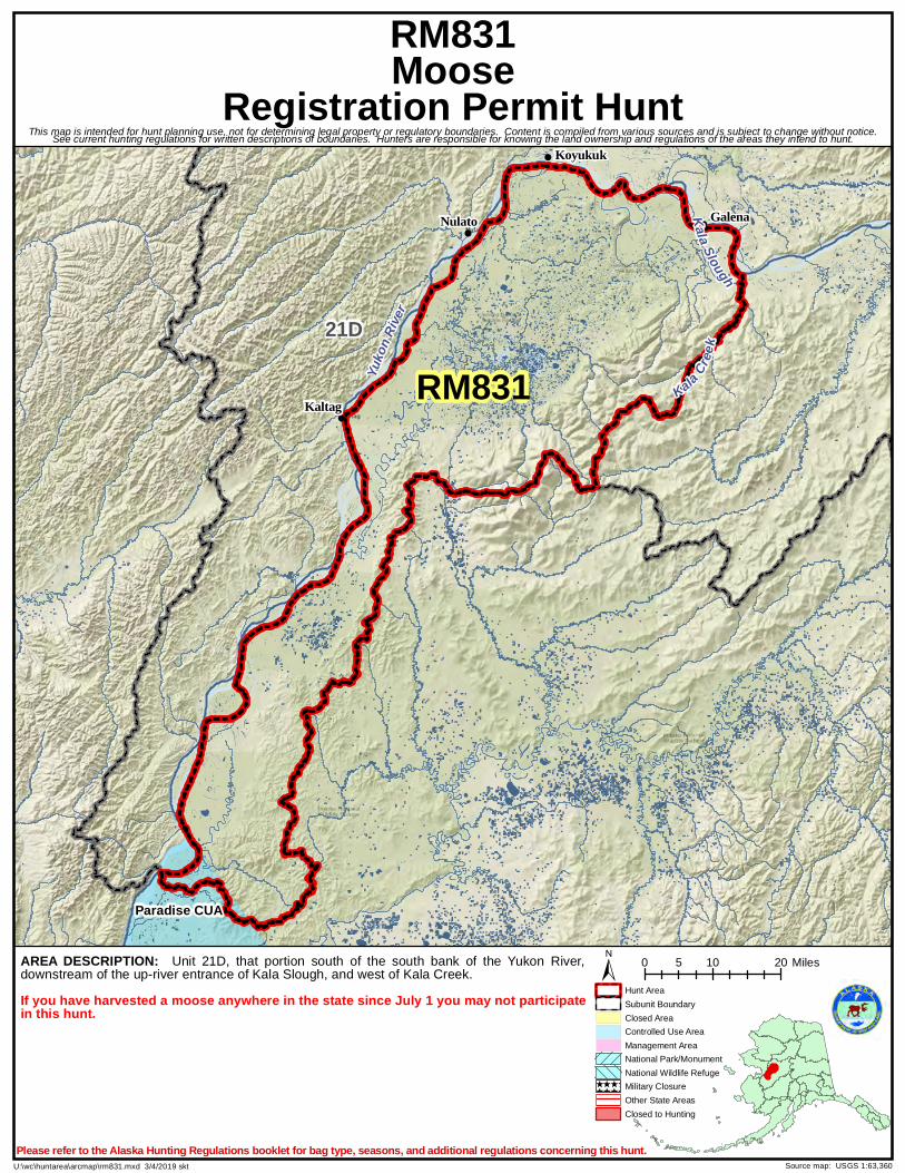
AREA DESCRIPTION: Unit 21D, that portion south of the south bank of the Yukon River,downstream of the up-river entrance of Kala Slough, and west of Kala Creek.If you have harvested a moose anywhere in the state since July 1 you may not participatein this hunt.

±Hunt Area

Closed AreaControlled Use AreaManagement AreaNational Park/Monument

Subunit Boundary

Other State AreasMilitary Closure

^̂ ^̂ ^^̂ ^̂ ^^̂ ^̂ ^^̂ ^̂ ^

Closed to Hunting

National Wildlife Refuge

This map is intended for hunt planning use, not for determining legal property or regulatory boundaries. Content is compiled from various sources and is subject to change without notice.See current hunting regulations for written descriptions of boundaries. Hunters are responsible for knowing the land ownership and regulations of the areas they intend to hunt.

Please refer to the Alaska Hunting Regulations booklet for bag type, seasons, and additional regulations concerning this hunt.