rl3/2005 – narrawa creek - mrt home
TRANSCRIPT

RL3/2005 – Narrawa Creek
Annual Report to May 2007.
Robert Reid - Exploration Manager and John McDougall – Exploration Geologist May 2007
Contents Summary ............................................................................................................................. 3 Introduction......................................................................................................................... 4 Tenure ................................................................................................................................. 5 Logistics.............................................................................................................................. 5 Regional Geology ............................................................................................................... 5 Narrawa Creek Area Geology............................................................................................. 6 Work Completed................................................................................................................. 9
Narrawa Creek Drilling................................................................................................... 9 Trenching at the 666 Lode ............................................................................................ 17 Mineralisation Model.................................................................................................... 19 Resource........................................................................................................................ 20
Conclusion and Discussion of Exploration Potential........................................................ 22 References......................................................................................................................... 25
Summary During 2005 Frontier Resources Ltd. targeted gold and base metal mineralisation in the Narrawa Creek area, within EL29/2003 which has now been converted in part to RL 3/2005. 16 drill holes for 749.1m were completed around the Higgs deposit with some very positive results. The remainder of the RL also has excellent untested potential with VLF-EM anomalies potentially indicating extension of the Higgs lode and mineralised lodes parallel to this trend. Testing of one of these lodes produced an intersection of 31.9m @ 1.2 g/t Au.
The retention licence at Narrawa Creek covers 2.75 sq km and includes the historic Higgs Gold Mine with a current inferred (non-JORC compliant) resource of 205,000tonnes @ 2.7g/t Au, 1.38% Pb, 1.07% Zn and 41g/t Ag. Great potential exists to delineate additional substantial resources which could be mined and then toll treated locally (Intec-Hellyer or Rosebery). Work conducted by Frontier Resources after the resource calculation and RL application extended the Higgs Resource to the south east by a further 32.5m of strike length, albeit with weaker mineralisation. Surrounding targets remain poorly tested. Current Mineral Resources Tasmania expenditure commitment is $100,000, shared with the nearby RL4/2005 (River Lea). Approximately $200,000 was spent on the 2005 drilling program after the RL application was lodged. This expenditure adequately meets the outstanding commitment for the current tenure period.
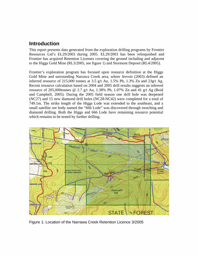
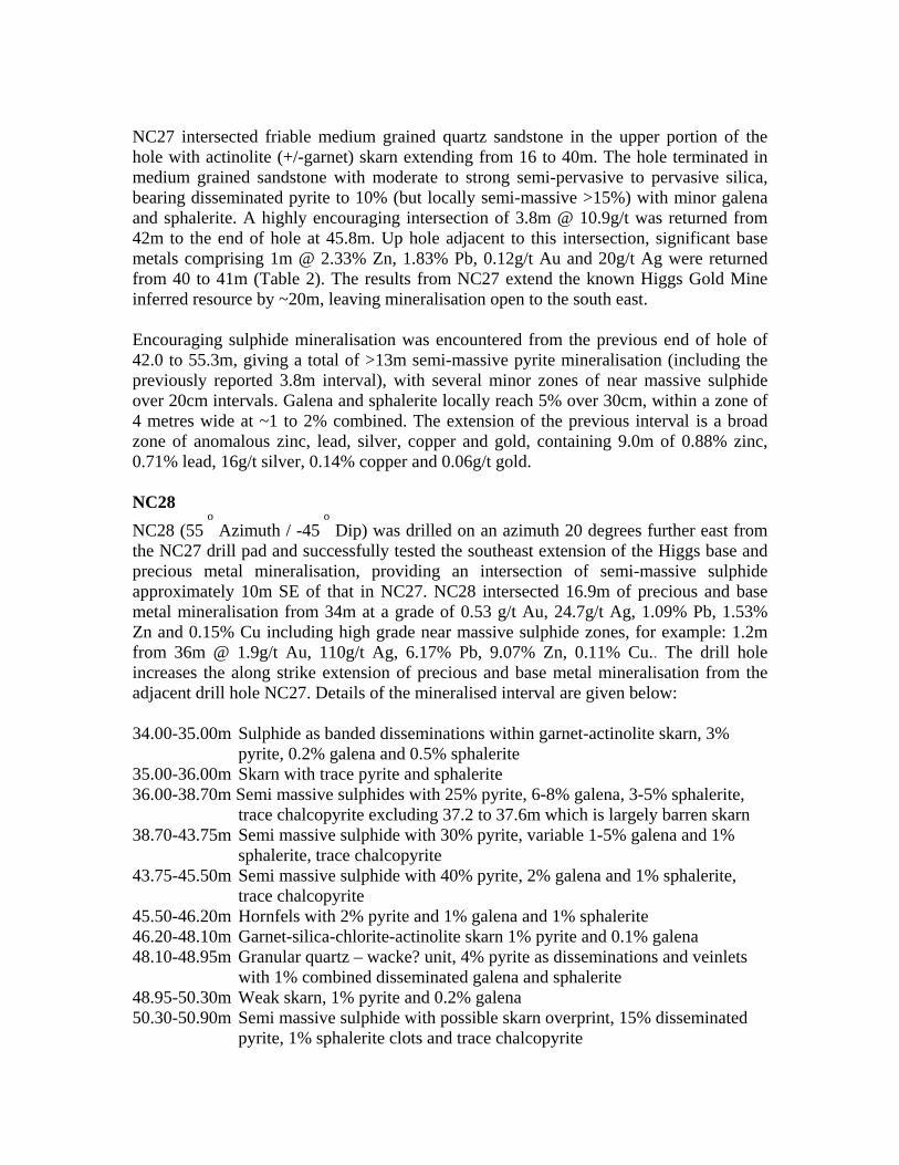
Introduction This report presents data generated from the exploration drilling programs by Frontier Resources Ltd’s EL29/2003 during 2005. EL29/2003 has been relinquished and Frontier has acquired Retention Licenses covering the ground including and adjacent to the Higgs Gold Mine (RL3/2005, see figure 1) and Stormont Deposit (RL4/2005).
Frontier’s exploration program has focused upon resource definition at the Higgs Gold Mine and surrounding Narrawa Creek area, where Jervois (2003) defined an inferred resource of 215,000 tonnes at 3.5 g/t Au, 1.5% Pb, 1.3% Zn and 23g/t Ag. Recent resource calculation based on 2004 and 2005 drill results suggests an inferred resource of 205,000tonnes @ 2.7 g/t Au, 1.38% Pb, 1.07% Zn and 41 g/t Ag (Reid and Campbell, 2005). During the 2005 field season one drill hole was deepened (NC27) and 15 new diamond drill holes (NC28-NC42) were completed for a total of 749.1m. The strike length of the Higgs Lode was extended to the southeast, and a small satellite ore body named the “666 Lode” was discovered through trenching and diamond drilling. Both the Higgs and 666 Lode have remaining resource potential which remains to be tested by further drilling.
Figure 1: Location of the Narrawa Creek Retention Licence 3/2005
Tenure EL29/2003 was granted to TasGold Ltd. following a successful ERA tender in 2003. EL29/2003 was converted to RL3/2005 (Narrawa Creek) and 4/2005 (River Lea) in late 2005, at approximately this time TasGold Ltd changed it’s name to Frontier Resources Ltd. Current Mineral Resources Tasmania expenditure commitment is $100,000, shared with the nearby RL4/2005 (River Lea).
Logistics The Narrawa Creek Prospect is located 20km southwest of Sheffield, 40km from Devonport, and is accessed by a 1.5 km long, well drained, all-weather unsealed track linking directly to the sealed Cradle Mountain Link Road. Potential toll treatment facilities are Intec Limited’s concentration facility on the old Hellyer mine site and Zinifex Limited’s Mill at Rosebery.
Regional Geology A good summary of the regional geology is given in Purvis (2000) and an early comprehensive account is provided by Jennings’ (1963) report on the Middlesex inch to a mile map sheet. More recently the WTRMP (Western Tasmanian Minerals Program; Morrison et. al., 2003) highlight the exploration potential for intrusion related gold related to the Devonian aged Dolcoath Granite, intruding Cambrian Mount Read Volcanics and Denison Group correlates. The Bond Range Porphyry equivalents and the undifferentiated Bull Creek Volcanics form limited outcrop within the RL boundaries. These rock types are equivalent to the Cambrian Mt Read Volcanics and probably underlie the Ordovician sequence over the Southern part of the EL. The RL comprises of Late Cambrian to Ordovician age sedimentary rocks (Denison Group) which Jennings (1963) defined as Roland Conglomerate overlain by Moina Sandstone, both having a true thicknesses of approximately 270m, inturn overlain by Gordon Limestone of 1000m thickness. The contacts between these units are believed to be transitional and conformable. The Late Cambrian Roland Conglomerate is the basal unit, comprising dense recrystallised quartz-quartzite-schist bearing clast supported conglomerate and sandstone. The Roland conglomerate is usually pink (haematitic) or white and whilst predominantly coarse, some sandy lenses are evident. Basal beds commonly contain Cambrian volcanic clasts and the unit thins to the south, possibly indicating the basin received much of its
input from the Pre-Cambrian craton. Fining upwards is relatively common and repeats of similar strata probably indicate repeated uplift at the time of deposition. In the vicinity of the Dolcoath Granite, the Roland Conglomerate is almost wholly recrystallised and forms a dense silicified quartzite appearing rock with ghosted clast outlines (Jennings, 1963). The overlying upward continuation of the Roland Conglomerate is the Moina Sandstone, typically comprising fine grained marine sandstone, quartzite, shale and conglomerate. Lithologies in the Higgs - Narrawa Reward area are considered to represent the upper transitional units, located beneath the Gordon Group limestones and host to the Narrawa Reward and Higgs prospects. Gordon Limestone, overlying the Moina Sandstone, comprises stylolitic limestones with limited shale beds. The Devonian-aged Dolcoath Granite is an oxidised crystal fractionated I-type granite intruding the Mount Read Volcanics and Ordovician Denison Group as a small 4km2 wide stock with significant sub surface extent, described by Morrison (et. al., 2003) as covering an area of ~50km2 where the granite is <500m below the surface. This granite spine forms an east-west elongate body, extending west of the main granite outcrop in the Forth River valley. The granite is mostly a medium to coarse grained alkali-feldspar I type granite with extensively greisenised margins. Devonian porphyry dykes are evident in drill core at Narrawa Creek as medium grained quartz-biotite porphyry with a fine yellowish groundmass. The granite has a zoned aureole with probable magnetite destruction proximal to the intrusion. The outer halo is however quite magnetic. The granite may have been forcefully intruded and could be responsible for causing shallow tilt of hinge lines and bedding to the west away from the stock in the vicinity of Narrawa Creek. There is local contact metamorphism evident at Narrawa Creek in the form of calc-silicate skarns and biotisation of sandstones. The Moina Sandstone and enclosing stratigraphy was faulted during the Devonian Tabberabberan Orogeny. Within the EL, Jennings (1963) notes a minimum of two fold trends (E-W and NW-SE) and another NNE trend. Castro and Fleming (1989) considered the major east –west trending structures with folds to be large scale, symmetrical and open. They were later overprinted by a prominent north-west trending pattern of smaller asymmetrical folds, often accompanied by drag folding and deep seated faults on the limbs of the major folds. The NW orientated faults are apparent in the regional magnetics and may have been synchronous with granite intrusion.
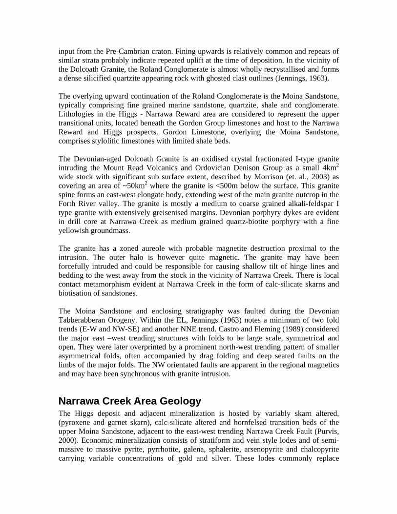
Narrawa Creek Area Geology The Higgs deposit and adjacent mineralization is hosted by variably skarn altered, (pyroxene and garnet skarn), calc-silicate altered and hornfelsed transition beds of the upper Moina Sandstone, adjacent to the east-west trending Narrawa Creek Fault (Purvis, 2000). Economic mineralization consists of stratiform and vein style lodes and of semi-massive to massive pyrite, pyrrhotite, galena, sphalerite, arsenopyrite and chalcopyrite carrying variable concentrations of gold and silver. These lodes commonly replace
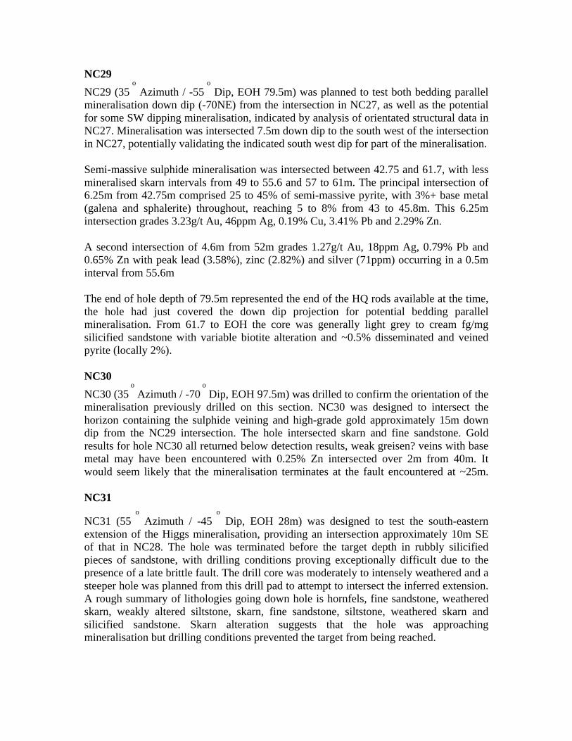
coarser sandstone horizons in the cores of anticlines and along faults. Ore-bearing zones are frequently enveloped by intense pyroxene and/or garnet skarn alteration (see mineralisation model below – figure 2) which is variably associated with lower grade disseminated base metal sulphides and Au.
Figure 2: Narrawa Creek Mineralisation Model (pre-greisen and late faulting) North West striking, moderately NE dipping faults are evident at the western margin of the Higgs Mine mineralisation and through Narrawa Creek itself, with offsets adjacent to anticlinal axis. These faults locally host massive base-metal bearing veins (such as in NC22). The existence of north – south to south east trending faults inferred by Jervois cannot be confirmed but these faults are likely to exist. The existence of the roughly east – west trending Narrawa Creek Fault cannot be confirmed. Northwest striking, moderately southwest dipping greisen veins, locally bearing remobilised base metals, are evidently late overprinting the primary north east dipping base metal mineralisation. A similarly orientated north west striking, south west dipping late brittle style fault has recently been identified along the south western margin of the

Higgs inferred resource. This fault separates mineralised host rock from little altered quartz sandstone in the hanging wall to the south west. Semi-pervasive and disseminated sulphide zones extend deeper than the current inferred resource beneath Higgs, but Au and base metals are depleted at depth in ND3, beneath the south eastern end of Higgs. Comparatively, strong gold mineralisation was intersected closer to surface in NC27, located south of ND3. These observations highlight the erratic nature of gold distribution. Gold is noted by previous explorers to be elevated with high sulphides, but also mutually exclusive, possibly partly resulting from a separate mineralising event (Purvis, 2000). Gold mineralisation was considered to be related to biotisation of the host rocks. Whereas, greisen is thought to be unrelated to Au mineralisation, a relationship supported in Table 1, showing poor correlation between analysis for gold and greisen related bismuth and tungsten. Good correlation exists between Pb, Zn and Ag, whilst weak correlation exists between Bi and W. Au shows very weak correlation with Pb, Zn and Ag in drill core. Drill Core
Au_ ppm
Ag_ ppm
As_ ppm
Cu_ ppm
Pb_ ppm
Zn_ ppm
Bi_ ppm
Sn_ ppm
W_ ppm
Mo_ ppm
Au_ppm 1.00 Ag_ppm 0.31 1.00 As_ppm 0.00 0.06 1.00 Cu_ppm 0.39 0.31 0.04 1.00 Pb_ppm 0.38 0.83 0.01 0.35 1.00 Zn_ppm 0.42 0.82 0.01 0.40 0.92 1.00 Bi_ppm 0.01 0.02 0.01 0.15 0.00 -0.01 1.00 Sn_ppm -0.04 -0.04 -0.02 -0.06 -0.03 -0.03 -0.05 1.00 W_ppm -0.01 0.02 0.00 0.07 -0.02 -0.02 0.58 -0.01 1.00 Mo_ppm -0.02 -0.02 -0.01 -0.05 -0.02 -0.02 -0.03 -0.01 0.15 1.00
Table 1: Correlation Coefficients for elements analysed from drill core
Mapped geological detail in the Narrawa Creek area is scant, the Moina Sandstone is considered to be folded about an open E-W synclinal axis running along Narrawa Creek. The creek is also known to host a parallel fault, as shown by offset units in MRT mapping and drilling by Jervois (Purvis, 2000) and Frontier Resources. The influence of folding related to interpreted NW trending magnetic and geochemical lineaments passing through the Higgs – Narrawa Reward area is unclear, but possibly provides structural control for the Higgs mineralisation. A mineralisation model akin to that at the nearby Round Mountain Mine is being considered (see figure 2). Here, anticlinal folds plunge shallowly NW (15
0
to 3050
) and host Pb-Zn-Ag-Au mineralisation as shoots of 25ft width and 20ft depth with some lateral spreading of the ore down the apices of the folds (Macintosh Reid, 1929; GSB 29).
Mineralisation at Higgs and Narrawa Reward is considered to be hosted in highly faulted Transition Beds of the upper Moina Sandstone, adjacent to the east-west trending Narrawa Creek Fault (Purvis, 2000), which likely forms a structural zone rather than a
specific fault. In outcrop, the Moina Sandstone is typically seen as a quartz sandstone and siltstone. In drill core, granule lithic sandstone and conglomerate facies are evident on the southwestern footwall margin of the semi massive sulphide mineralisation. Drill core replacement textures in these lithologies indicate this unit at least locally acts as a hydrothermal fluid conduit. Drill section analysis also shows three porphyry intrusives of NW to NNW strike and steeply NE dip between Higgs and Narrawa Reward.
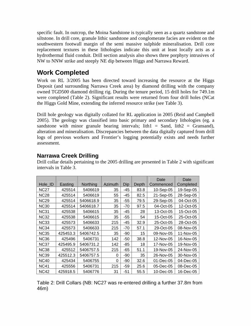
Work Completed Work on RL 3/2005 has been directed toward increasing the resource at the Higgs Deposit (and surrounding Narrawa Creek area) by diamond drilling with the company owned TGD500 diamond drilling rig. During the tenure period, 15 drill holes for 749.1m were completed (Table 2). Significant results were returned from four drill holes (NCat the Higgs Gold Mine, extending the inferred resource strike (see Table 3).
Drill hole geology was digitally collated for RL application in 2005 (Reid and Campbell 2005). The geology was classified into basic primary and secondary lithologies (eg. a sandstone with minor granule bearing intervals; lith1 = Sand, lith2 = Gransand), alteration and mineralisation. Discrepancies between the data digitally captured from drill logs of previous workers and Frontier’s logging potentially exists and needs further assessment. Narrawa Creek Drilling Drill collar details pertaining to the 2005 drilling are presented in Table 2 with significant intervals in Table 3.
Hole_ID Easting Northing Azimuth Dip DepthDate
CommencedDate
Completed NC27 425514 5406619 35 -45 83.8 10-Sep-05 19-Sep-05 NC28 425514 5406619 55 -45 82.5 21-Sep-05 28-Sep-05 NC29 425514 5406618.9 35 -55 79.5 29-Sep-05 04-Oct-05 NC30 425514 5406618.7 35 -70 97.5 04-Oct-05 12-Oct-05 NC31 425538 5406615 35 -45 28 13-Oct-05 15-Oct-05 NC32 425538 5406615 35 -55 54 15-Oct-05 25-Oct-05 NC33 425573 5406633 215 -45 32.9 25-Oct-05 28-Oct-05 NC34 425573 5406633 215 -70 57.1 29-Oct-05 08-Nov-05 NC35 425453.3 5406742.5 35 -90 15 09-Nov-05 11-Nov-05 NC36 425496 5406731 142 -50 38.8 12-Nov-05 16-Nov-05 NC37 425495.9 5406731.2 142 -85 18 17-Nov-05 19-Nov-05 NC38 425512 5406757.5 215 -65 51.1 19-Nov-05 24-Nov-05 NC39 425512.3 5406757.5 0 -90 35 26-Nov-05 30-Nov-05 NC40 425434 5406755 0 -90 32.6 01-Dec-05 04-Dec-05 NC41 425556 5406731 215 -59 25.6 05-Dec-05 08-Dec-05 NC42 425918.5 5406776 31 -51 55.5 10-Dec-05 16-Dec-05
Table 2: Drill Collars (NB: NC27 was re-entered drilling a further 37.8m from 46m)
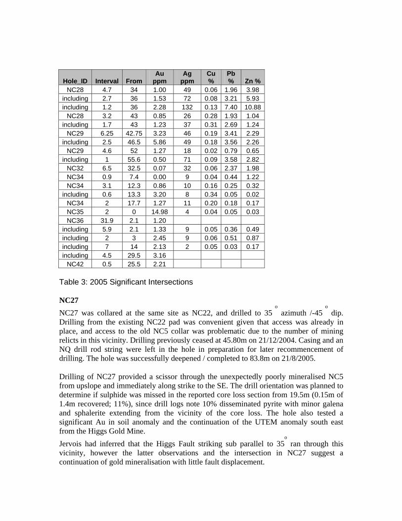
Hole_ID Interval From Au
ppm Ag
ppm Cu %
Pb % Zn %
NC28 4.7 34 1.00 49 0.06 1.96 3.98 including 2.7 36 1.53 72 0.08 3.21 5.93 including 1.2 36 2.28 132 0.13 7.40 10.88
NC28 3.2 43 0.85 26 0.28 1.93 1.04 including 1.7 43 1.23 37 0.31 2.69 1.24
NC29 6.25 42.75 3.23 46 0.19 3.41 2.29 including 2.5 46.5 5.86 49 0.18 3.56 2.26
NC29 4.6 52 1.27 18 0.02 0.79 0.65 including 1 55.6 0.50 71 0.09 3.58 2.82
NC32 6.5 32.5 0.07 32 0.06 2.37 1.98 NC34 0.9 7.4 0.00 9 0.04 0.44 1.22 NC34 3.1 12.3 0.86 10 0.16 0.25 0.32
including 0.6 13.3 3.20 8 0.34 0.05 0.02 NC34 2 17.7 1.27 11 0.20 0.18 0.17 NC35 2 0 14.98 4 0.04 0.05 0.03 NC36 31.9 2.1 1.20
including 5.9 2.1 1.33 9 0.05 0.36 0.49 including 2 3 2.45 9 0.06 0.51 0.87 including 7 14 2.13 2 0.05 0.03 0.17 including 4.5 29.5 3.16
NC42 0.5 25.5 2.21 Table 3: 2005 Significant Intersections NC27 NC27 was collared at the same site as NC22, and drilled to 35
o azimuth /-45
o dip.
Drilling from the existing NC22 pad was convenient given that access was already in place, and access to the old NC5 collar was problematic due to the number of mining relicts in this vicinity. Drilling previously ceased at 45.80m on 21/12/2004. Casing and an NQ drill rod string were left in the hole in preparation for later recommencement of drilling. The hole was successfully deepened / completed to 83.8m on 21/8/2005.
Drilling of NC27 provided a scissor through the unexpectedly poorly mineralised NC5 from upslope and immediately along strike to the SE. The drill orientation was planned to determine if sulphide was missed in the reported core loss section from 19.5m (0.15m of 1.4m recovered; 11%), since drill logs note 10% disseminated pyrite with minor galena and sphalerite extending from the vicinity of the core loss. The hole also tested a significant Au in soil anomaly and the continuation of the UTEM anomaly south east from the Higgs Gold Mine. Jervois had inferred that the Higgs Fault striking sub parallel to 35
o ran through this
vicinity, however the latter observations and the intersection in NC27 suggest a continuation of gold mineralisation with little fault displacement.
NC27 intersected friable medium grained quartz sandstone in the upper portion of the hole with actinolite (+/-garnet) skarn extending from 16 to 40m. The hole terminated in medium grained sandstone with moderate to strong semi-pervasive to pervasive silica, bearing disseminated pyrite to 10% (but locally semi-massive >15%) with minor galena and sphalerite. A highly encouraging intersection of 3.8m @ 10.9g/t was returned from 42m to the end of hole at 45.8m. Up hole adjacent to this intersection, significant base metals comprising 1m @ 2.33% Zn, 1.83% Pb, 0.12g/t Au and 20g/t Ag were returned from 40 to 41m (Table 2). The results from NC27 extend the known Higgs Gold Mine inferred resource by ~20m, leaving mineralisation open to the south east. Encouraging sulphide mineralisation was encountered from the previous end of hole of 42.0 to 55.3m, giving a total of >13m semi-massive pyrite mineralisation (including the previously reported 3.8m interval), with several minor zones of near massive sulphide over 20cm intervals. Galena and sphalerite locally reach 5% over 30cm, within a zone of 4 metres wide at ~1 to 2% combined. The extension of the previous interval is a broad zone of anomalous zinc, lead, silver, copper and gold, containing 9.0m of 0.88% zinc, 0.71% lead, 16g/t silver, 0.14% copper and 0.06g/t gold. NC28 NC28 (55
o Azimuth / -45
o Dip) was drilled on an azimuth 20 degrees further east from
the NC27 drill pad and successfully tested the southeast extension of the Higgs base and precious metal mineralisation, providing an intersection of semi-massive sulphide approximately 10m SE of that in NC27. NC28 intersected 16.9m of precious and base metal mineralisation from 34m at a grade of 0.53 g/t Au, 24.7g/t Ag, 1.09% Pb, 1.53% Zn and 0.15% Cu including high grade near massive sulphide zones, for example: 1.2m from 36m @ 1.9g/t Au, 110g/t Ag, 6.17% Pb, 9.07% Zn, 0.11% Cu.. The drill hole increases the along strike extension of precious and base metal mineralisation from the adjacent drill hole NC27. Details of the mineralised interval are given below: 34.00-35.00m Sulphide as banded disseminations within garnet-actinolite skarn, 3%
pyrite, 0.2% galena and 0.5% sphalerite 35.00-36.00m Skarn with trace pyrite and sphalerite 36.00-38.70m Semi massive sulphides with 25% pyrite, 6-8% galena, 3-5% sphalerite,
trace chalcopyrite excluding 37.2 to 37.6m which is largely barren skarn 38.70-43.75m Semi massive sulphide with 30% pyrite, variable 1-5% galena and 1%
sphalerite, trace chalcopyrite 43.75-45.50m Semi massive sulphide with 40% pyrite, 2% galena and 1% sphalerite,
trace chalcopyrite 45.50-46.20m Hornfels with 2% pyrite and 1% galena and 1% sphalerite 46.20-48.10m Garnet-silica-chlorite-actinolite skarn 1% pyrite and 0.1% galena 48.10-48.95m Granular quartz – wacke? unit, 4% pyrite as disseminations and veinlets
with 1% combined disseminated galena and sphalerite 48.95-50.30m Weak skarn, 1% pyrite and 0.2% galena 50.30-50.90m Semi massive sulphide with possible skarn overprint, 15% disseminated
pyrite, 1% sphalerite clots and trace chalcopyrite
NC29 NC29 (35
o Azimuth / -55
o Dip, EOH 79.5m) was planned to test both bedding parallel
mineralisation down dip (-70NE) from the intersection in NC27, as well as the potential for some SW dipping mineralisation, indicated by analysis of orientated structural data in NC27. Mineralisation was intersected 7.5m down dip to the south west of the intersection in NC27, potentially validating the indicated south west dip for part of the mineralisation. Semi-massive sulphide mineralisation was intersected between 42.75 and 61.7, with less mineralised skarn intervals from 49 to 55.6 and 57 to 61m. The principal intersection of 6.25m from 42.75m comprised 25 to 45% of semi-massive pyrite, with 3%+ base metal (galena and sphalerite) throughout, reaching 5 to 8% from 43 to 45.8m. This 6.25m intersection grades 3.23g/t Au, 46ppm Ag, 0.19% Cu, 3.41% Pb and 2.29% Zn. A second intersection of 4.6m from 52m grades 1.27g/t Au, 18ppm Ag, 0.79% Pb and 0.65% Zn with peak lead (3.58%), zinc (2.82%) and silver (71ppm) occurring in a 0.5m interval from 55.6m The end of hole depth of 79.5m represented the end of the HQ rods available at the time, the hole had just covered the down dip projection for potential bedding parallel mineralisation. From 61.7 to EOH the core was generally light grey to cream fg/mg silicified sandstone with variable biotite alteration and ~0.5% disseminated and veined pyrite (locally 2%). NC30 NC30 (35
o Azimuth / -70
o Dip, EOH 97.5m) was drilled to confirm the orientation of the
mineralisation previously drilled on this section. NC30 was designed to intersect the horizon containing the sulphide veining and high-grade gold approximately 15m down dip from the NC29 intersection. The hole intersected skarn and fine sandstone. Gold results for hole NC30 all returned below detection results, weak greisen? veins with base metal may have been encountered with 0.25% Zn intersected over 2m from 40m. It would seem likely that the mineralisation terminates at the fault encountered at ~25m. NC31
NC31 (55 o
Azimuth / -45 o
Dip, EOH 28m) was designed to test the south-eastern extension of the Higgs mineralisation, providing an intersection approximately 10m SE of that in NC28. The hole was terminated before the target depth in rubbly silicified pieces of sandstone, with drilling conditions proving exceptionally difficult due to the presence of a late brittle fault. The drill core was moderately to intensely weathered and a steeper hole was planned from this drill pad to attempt to intersect the inferred extension. A rough summary of lithologies going down hole is hornfels, fine sandstone, weathered skarn, weakly altered siltstone, skarn, fine sandstone, siltstone, weathered skarn and silicified sandstone. Skarn alteration suggests that the hole was approaching mineralisation but drilling conditions prevented the target from being reached.
NC32 NC32 (55
o Azimuth / -55
o Dip, EOH 54m) was collared on the same drill pad as NC31
however the hole was drilled 10 degrees steeper. Similar difficult drilling conditions were encountered but eventually overcome by a team determined to drill the target horizon. Disseminated and vein sulphide mineralisation was intersected over approximately 11m from 32.55m and terminating at 43.50m and is bounded by less mineralised skarn intervals. The sulphidic intersections are typically bands of disseminated sulphide averaging 12-15% pyrite, 2% galena and 2% sphalerite with intermittent veins of sphalerite, galena or silica-pyrite. Locally the mineralisation is semi-massive over 5cm intervals and silicification is variable but always present throughout the intersection. The host lithologies vary from siltstones to granule sandstones. Details of the mineralised interval are given below: 32.55 – 39.00m Silica-sulphide, strongly fractured and common vuggy pyrite veins, light grey silica with semi-massive sulphide bands of 4-6% galena, 4% sphalerite, 10% pyrite over 10cm intervals (true thickness ~5cm), bedding sub-parallel veins in interbedded finely laminated mudstone-siltstone and fine sandstone beds to 2cm. 39.00 – 40.50m Abundant disseminated pyrite to 25%, near massive in part, strong silica alteration possibly replacing a medium grained sandstone, moderate quartz veining. Trace base metal sulphides. 40.50 – 40.90m Friable semi-massive sulphide disseminated in granule sandstone and medium grained sandstone, poor core recovery, 10% pyrite, 8% sphalerite, 8% galena. 40.90 – 41.70m Strongly silicified medium sandstone with disseminated and vein sulphide, poor core recovery, 4% pyrite, 1% sphalerite, 1% galena. 41.70 – 43.50m Moderately silicified fine grained sandstone, 15-20% pyrite, 5% galena, trace sphalerite, poor core recovery. NC32 assayed 10.2m grading 1.59% Pb, 1.44% Zn, 25g/t Ag and 0.05 g/t Au from 31.5m, including 6m grading 2.50% Pb, 1.97% Zn, 34g/t Ag and 0.07 g/t Au from 33m. NC33 NC33 (215
o Azimuth / -45
o Dip, EOH 32.9m) was terminated after it was apparent that a
minor fault displaces the mineralisation. Only minor alteration was noted in fine grained sandstone which possibly represents a footwall litholgy. NC34 NC34 (215
o Azimuth / -70
o Dip, EOH 57.1m) was drilled from the same drill pad as
hole NC33, but is more strongly altered. The hole included mineralisation with more chalcopyrite than previously seen in the Higgs Deposit, but with notably less base metals than previous intersections such as NC29 and NC32. It is also likely that a previously inferred post mineralising fault has displaced the Higgs lode to the North, on the eastern side of a N-S striking fault between this hole and the previous extension (NC32) to the deposit. The drill hole returned a 14.5m intersection of skarn altered fine sediments and mineralised interbedded sandstones between 7.4 and 21.9m. Zones of anomalous gold and base metals were carefully sampled and mineralisation is clearly segregated into

distinctly gold rich and base metal rich zones. In NC34 gold appears to be associated with the massive pyrrhotite mineralisation pervasively replacing the matrix of granule sandstones. There is also now evidence that gold and copper are likely to be genetically related, with peak gold grades coincident with areas of >0.2% Cu noted in drill core as spotty chalcopyrite. Details of the mineralised interval are given below: 7.4 - 8.3m 0.9m grading 9g/t Ag, 0.44% Pb and 1.22% Zn in bands of semi-massive sulphide 8.3 – 10.3 Barren skarn 10.3 – 12.3 2m grading 12g/t Ag, 1% Pb and 0.86% Zn in bands of semi massive sulphide replacing granule sandstone host rocks 12.3 – 13.9 1.6m grading 1.1g/t Au, 6.9g/t Ag, 0.22% Cu, 0.11% Pb and 0.25% Zn in bands of semi massive sulphide replacing granule sandstone host rocks includes 0.6m grading 3.2 g/t Au from 13.3m 13.9 – 14.4 0.5m grading 0.25% combined Pb/Zn in silica-sulphide bands and sulphide veinlets 14.4 – 15.4 1m grading 0.43 g/t Au, 12g/t Ag and 0.51% Pb and 0.53% Zn in biotised sandstone with semi-massive sulphide replacing coarse beds 15.4 – 16.2 0.8m grading 0.3% Pb in cream and green skarn 16.2 – 17.7 1.5m grading 0.75% combined Pb/Zn and 7.3g/t Ag in cream and pink garnet>actinolite skarn 17.7 – 19.7 2m grading 1.27g/t Au, 0.2% Cu and 10.5 g/t Ag with peak combined Pb/Zn of 0.53% over 1m in semi-massive sulphide bands with pyrrhotite>>other sulphides 19.7 – 21.9 2.2m grading 10.9g/t Ag and 0.53% Pb and 0.54% Zn including peak gold of 0.33g/t in the last metre in garnet-actinolite skarn altered coarse sandstone AND 44.0 – 48.0m 4m grading 15g/t Ag and 0.44% Pb and 0.61% Zn in altered coarse sandstone. The main mineralisation in NC34 was not as consistently gold mineralised as some previous holes and the less intense alteration made observing the metal zonation easier. These observations will be used to target the mineralisation with the best gold potential and may speed up the process of locating future satellite deposits. The silver content of mineralisation is also clearly related to the galena and sphalerite mineralisation with peak silver values consistently in intersection with >1% combined Pb and Zn. Work is ongoing to understand the timing on gold-copper and Pb-Zn-Ag mineralisation, however recent evidence from NC28, NC29, NC32, NC34, NC36 and NC37 suggest that associations may be related to different fluid phases of the fractionating Dolcoath Granite and associated porphyry dykes. NC35 Before it was physically possible (due to rainfall) to target the outcropping sulphide mineralisation exposed in recent excavator trenches that returned up to 8.66 g/t gold, a short vertical drill hole (NC35) was sited on the main Narrawa access track to test the
down dip extent of the gossan encountered in the NC25 drill rig anchor hole which contained 1.5m of 25.5 g/t Au (this was the entire length of the anchor hole). NC35 encountered the same style of mineralisation at surface comprising limonite and goethite dominated gossan with relict sulphide boxwork from 0-2m. This is progressively less weathered and limonitic to 2.95m where the core is less weathered and moderately skarn altered. Drill core was sampled over 1m intervals and a 3m intersection of gossan (transitional with weathered skarn over the last 1m) assayed 10.2 g/t with peak gold of 1m grading 23.8 g/t Au from surface. This mineralisation is now interpreted to be on the edge of a shallowly WNW plunging mineralised fold which is more adequately tested by NC36. The mineralisation in the Narrawa Creek area trends on approximately 300 degrees and is potentially present at shallow depths further to the west. Drilling at NC35 was partially successful, however the priority remained testing the massive sulphide in outcrop (the 666 Lode) from a more favourable position than the first hole (NC01) that showed any potential in this sector, which was sited on (perhaps also somewhat past) the mineralised zone and apparently drilled down dip returning 11.7m of 1.31 g/t gold plus base metal and silver credits. NC36 NC36 targeted the trenched 666 Lode by creating a drill pad in the ‘technically’ best position, as near as possible to the outcropping massive sulphide mineralisation. The location of a drill pad some 9m away from the outcropping mineralisation provided the first complete look at the mineralised lode and an intersection of 32.3m grading 1.19g/t Au from 1.7m (with dilution by 3m gold barren hornfels and skarn zone from 9 to 12m) was returned. Hole NC36 was drilled off the usual NE-SW section, on azimuth 140 degrees and dip -50 degrees, to intersect the known outcropping mineralisation and target a possible fold hinge. The hole intersected 3 mineralised horizons including galena and sphalerite rich replacement mineralisation, calc-silicate alteration with associated semi-massive and massive pyrite and 2m of massive pyrrhotite>pyrite in coarse grained skarn altered granule sandstones. These units are all coarse grained where mineralisation is strongest and are likely to represent multiple mineralised horizons similar to those identified in NC34 (being the most recent hole drilled at the Higgs Deposit), located ~100m to the SW.
Peak gold is again associated with highest amounts of copper (which is only present in trace amounts) and peak silver grade is again associated with areas of >1% combined Pb and Zn. These metal associations are consistent between the Higgs and the 666 lode suggesting that further lodes may be targeted using Cu in soil as a pathfinder for gold (which is spotty and unreliable) and possibly zinc (which is less mobile than lead in soils) to find peripheral silver rich mineralisation.
Individual intercepts within the weighted assay average of 32.3m grading 1.19g/t gold include:7.3m grading 1.09g/t Au from 1.7m in skarn altered granule sandstone with bands of massive sulphide including peak gold of 2m grading 2.45 g/t Au from 3m and including 6.3m of 10g/t Ag and 0.85% combined Pb/Zn from 1.7m, plus 7m grading 2.13g/t Au from 14m in strong calc-silicate altered coarse sandstone bearing 30% pyrite and interbedded un-mineralised fine sandstone and hornfels including 5m grading 2.67 g/t Au from 15m with peak gold 5.1 g/t over 1m associated with highest (trace) copper,
also including peak zinc of 0.8% over 1m from 19m plus 4.5m grading 2.19 g/t Au from 29.5m in pyrrhotised granule sandstone, including peak values of 0.5m grading 16.8 g/t Au in pyrrhotised granule sandstone bearing lesser pyrite and haematite NC37 NC37 was drilled on a steeper angle (142 degrees azimuth, 85 degrees, EOH 18m) from the same drill pad as NC36 and confirmed the existence of a narrow porphyry dyke that has been intersected in NC25, NC01 and a deep hole DD82DG1. This granite appears to have an associated hydrothermal breccia, consistent with observations made in NC25 in 2004. This breccia suggests that granite dykes and fluids ascend the Devonian faults (see figure 2). Gossan was intersected from surface, followed by a short interval of semi-massive sulphide, then skarn, hornfels, strongly silicified porphyry and silicified sandstone. The intervals returned 1.5m grading 0.14g/t gold, 16.3g/t silver, 0.52% lead and 0.21% zinc from 1.5m. NC38 NC38 was located to test the NC36 intersection on ‘traditional’ NE-SW section and appears to have intersected the moderately mineralised granule sandstone in the long NE limb of the 666 Lode. NC38 was stepped back ~30m on section from NC36 to test the down dip extent of mineralisation. The dominant lithologies intersected in the upper portion of the hole were interbedded fine and pebbly sandstones with one skarn altered granule bearing unit containing ~8% pyrite over 1.1m. Mid-hole, pyroxene – garnet skarn locally overprints hornfels and a 0.5m semi-massive sulphide (40%) interval from 25.2m was located adjacent to strong calc silicate altered sandstone; the remainder of the hole is silicified and broken fine and medium grained sandstones typical of the area. Intersections include 0.5m grading 1.5g/t gold (from 10.5m), in a limonitic quartz vein and 5.3m grading 0.2g/t gold (from 21.2m), enveloping the semi-massive sulphide interval. Assay results were disappointing. NC39 NC39 was drilled steeply beneath NC38 on the same azimuth and from the same drill pad. Lithological correlation with NC38 was readily evident, indicating that bedding dip is relatively flat in this area. A 17m zone of weakly anomalous base-metals was intersected from 9m in coarse and medium grained pervasively silicified, hornfels and skarnified sandstones. This intersection returned 17m grading 0.03g/t gold, 1.4g/t silver and 0.11% zinc and included 6m grading 0.2% zinc from 18.5m. NC40 NC40 tested the along strike extent of the NC25 gossan and narrow zones of moderately anomalous Pb, Zn and Cu were intersected from zones associated with late greisen veins. The relatively flat lying mineralized bedding intersected in drill holes NC38 and NC39, indicates that targeting in this area from up slope to the east, adjacent to a discreet magnetic anomaly may be more productive, however, accessing this site would require significant additional track work.

NC41 NC41 is located just north of the Narrawa Creek crossing and it tested the extent of skarn alteration encountered in NC26, in light of the flat bedding dips revealed by drill holes NC38 and 39. Alteration was similar to that in NC26. Lithologies encountered were rubbly at surface, progressing to limonitic sandstone, black green and pink magnetite-rich actinolite-garnet skarn, strongly broken fine sandstone and siltstone with weak skarn overprint and occasional greisen veins, the hole terminated in moderately broken strongly silicified medium grained sandstone. Analyses returned to 0.19g/t gold and 0.21% zinc. NC42 NC42 was located in the vicinity of NC04, some 400m down stream to the east of the Higgs Gold Mine workings and most of Frontier’s drilling to date. The hole bisected two moderate gold and base metal soil anomalies, drilling (035 degrees) perpendicular to the regional strike (-51 degrees dip). Intersected lithologies were strong hornfels, skarn and widespread silica veining; indicative of a hot mineralising system. From the collar to the end of hole, lithologies comprised moderately weathered skarn, laminated hornfels with a moderate pink and green pyroxene-rich skarn overprint and late quartz-phlogopite greisen veins, 30cm of massive pyrrhotite (>70%) and lesser chalcopyrite, light green strongly silicified skarn, light brown laminated hornfels, strong skarn altered hornfels with silica alteration haloes, skarn and hornfels replacing siltstone and granular sandstone respectively with strong silica stockwork type veining.
0.5m grading 2.21g/t gold (from 25m) was returned from an interval of massive pyrrhotite-chalcopyrite mineralisation, similar to the mineralisation containing the highest gold grades in NC36. A further encouraging mineral occurrence was a 2mm quartz-molybdenite vein (at 43.5m) at low angle to the drill core; an orientation typical of other greisen veins in the area, which dip moderately-steeply south west. The hole was terminated before target depth, due to mechanical problems with the drilling rig, in intense silicification and veining overprinting skarn alteration. An inferred synclinal fold hinge, which was the original intended target, is expected to be intersected if the drill hole is extended (casing left in hole). Trenching at the 666 Lode An excavator was utilised during October 2005 to dig 10 trenches and expose bedrock along the track on the north bank of Narrawa Creek. The objective was to test the extent and attitude of known gold anomalous and sulphide-rich mineralisation cropping out near/above the collar of drill hole NC01 and to fill in gaps in previous rock chip sampling. The trenching /channel sampling confirmed the high gold and base metal content of outcrop on the northern side of Narrawa Creek track and its prospectivity. Excavator trenches were generally dug perpendicular to the trend of the 666 Lode. Six trench sites successfully reached bedrock with another four unsuccessful trenches filled in immediately. Exposures were sampled by cutting ~5cm wide near vertical channels with a portable diamond blade rock saw. Outcrop containing gold and base metal
sulphide mineralisation at trenches 9 &10 was found to be >2m thick, bearing significant sulphide mineralisation (>10%), however, highly mineralized (>40% sulphide) areas show relatively narrow widths (generally <30 cm) and grade both vertically and horizontally into more weakly mineralised, moderately to strongly silicified or skarn altered fine-grained quartz sandstone.
The highest concentrations of both base metals and gold are intimately associated with lenses/beds of coarser-grained sandstone/granule conglomerate. The gold bearing sulphidic outcrop grades ~7g/t gold adjacent to the NC01 collar and it was exposed for ~6m along the track cutting, before the general orientations of the mineralisation and the track/trench cuts diverged. An impressive zone of near massive sulphide is evident, with a thickness >1.5m locally, bearing up to 10% galena and lying within silica-pyrite and possibly calc-silicate alteration. Trench 10 (located 66.6m up the road to the west of the creek crossing) was cut, then later extended because it showed significant sulphides with a thick gossanous rind. Beneath this a 1.2 by 0.7m surface of fresh galena-sphalerite rich (20% locally) semi-massive sulphide was exposed. Abundant pyrrhotite (to 10%) in moderately/ strongly magnetic portions provides an obvious aid to targeting with a weak magnetic linear feature evident. The mineralisation here is hosted in a fine to medium grained sandstone, contrary to other observed mineralisation which is strongest in the coarser units. The mineralisation is a minimum of 1.5m in true thickness and lies open in three directions, including up the bank, up the road, and underneath the road. The entire exposed section returned 1.5m grading 6.20 g/t gold + 49 g/t silver + 3.2% lead + 3.0% zinc and the peak gold=8.66g/t. The gold mineralisation is contained within a sandstone host (as at the apparently sub-parallel Higgs Deposit, located about 100m SW across the creek) with an apparent dip of about 45 degrees to the NE. This ‘enhanced’ zone of surface mineralisation was then targeted and intersected by 4 drill holes (NC36 + NC37 + NC38 + NC39). The down dip stratabound extension has been drilled previously, with an intersection of semi-massive sulphide from 93.5 to 96m, within an interval grading 7m of 0.26g/t gold, 11.3g/t silver, 0.72% lead and 0.76% zinc. At trench 9 (located 6m SE of trench 10 down the road), mineralisation is of lower intensity , with an average of 1.5m grading 1.70g/t gold, 21g/t silver, 0.75% lead and 0.40% zinc. Mineralisation stratigraphically underlying this outcrop has been tested by hole NC01 which intersected 10.9m of 1.4g/t gold from surface, with visible gold evident in the anchor hole. Significant sulphide mineralisation is evident for >2m vertically and may continue another 2m vertically above the outcrop, being the distance between the top of the exposure and the next outcrop of sulphide poor strongly silicified fine-grained green skarn. In the trench 9 & 10 area, contacts between coarser and finer sandstone units/lenses in outcrop suggest a roughly EW strike (110-120 degrees) with a relatively shallow dip to the north (25-35 degrees). Drill hole NC01 may have drilled underneath a substantial portion of the outcropping gold and base metal mineralisation as the gold/base metal mineralisation is largely stratigraphically controlled (coarser units) and the bedding apparently dips north. This was confirmed by weak mineralisation down dip in NC38 and NC39.
Mineralisation encountered 14m west from drill collar NC25 looked promising with a 2.2m exposure revealing abundant disseminated and sometimes dendritic pyrite (to 20%) averaging 5 to 10% in strongly silicified well sorted fine grained sandstone with minor thin coarser grained intervals. No visible base metal sulphides were noted. Gold and base metal assays were anomalous but low. A further 10m NW along the road, a trench in similarly strongly silicified sandstone with significantly less pyrite (2%) returned 1.4m of 0.08g/t gold. This horizon is equivalent to lithologies and alteration encountered to 7m depth in NC25 (with 1.5m of 25.5 g/t gold from surface) and is interpreted to lie in the hanging wall to the semi-massive base and precious metal bearing horizon. This means this trench did not test the target mineralised zone. The exposed sulphide rich mineralisation is apparently sandwiched between / enveloped by dark green, moderately to strongly silicified skarn with variable grain size and sulphide content of 0 to 2%, comprising mostly fine grained pyrite. At the north western most extent of sampling, the hanging wall to the base metal and gold bearing mineralised horizon is characterised by significant disseminated sulphide within strongly silicified sediments. The mineralisation apparently has 110-120 degree strike, running sub parallel to the road between NC01 and NC25. The gold-rich anchor hole for NC25 is likely related to the same stratigraphic horizon encountered in outcrop in trenches 9 and 10. Mineralisation apparently extends on ~NW orientation through the NC25 collar area. Mineralisation was missed in hole ND2 (adjacent to NC25) where sampling from 2m down hole returned no gold in the calc-silicate alteration. Gold anomalism extends to 3m in NC25, which combined with a 3m separation between adjacent drill holes, indicates potential for 6m true width for the mineralisation. This is in agreement with the down dip intersection of 3.7m of 0.42g/t gold, 19g/t silver, 1.27% lead & 1.33% zinc from 94.5m in DD82DG1, located slightly SE (~17m) of NC01. Extrapolation to the intersection in DD82DG1 suggests an overall dip of 45 NE and opens the possibility that an anticlinal closure exists in the NC01 vicinity, since dips are shallower. A laterally extensive EM anomaly extends through the area on a NW orientation with a length of ~500m and similarly, a linear magnetic anomaly lies sub-parallel to mineralisation with magnetite destruction apparent through this zone possibly representing hydrothermal alteration. Mineralisation Model ‘Modern’ exploration by RGC directed drill holes under the feeder faults for the Higgs Lode and only intersected the narrow down dip extent of mineralisation on the NE limb of folds and in narrow veins of mineralisation. Jervois Mining (late 1990’s) concentrated on the Higgs workings and defined a small resource below the Higgs Mine, they interpreted that the mineralised horizon was bounded by faults and were probably put off by RGC’s interpretation that the mineralised horizon is part of the transition beds within the upper Moina sandstone that had no depth extent. This appears to be partially correct in that the horizon is not voluminous, however, Frontier drilling has indicated that it is strongly mineralised in fold hinges and laterally repeated. Frontier believes there is also significant potential for similar prospective units in other parts of the stratigraphy. Frontier initially drilled below the Jervois resource and reduced the down dip potential of the mineralisation of the Higgs Deposit, however, our recent drilling of the inferred
anticlinal hinge has proved to be more productive and the resource zone has been extended along strike to the south east. The model for mineralisation currently drilled at Narrawa Creek is Au bearing skarns, however due to the erratic nature of skarn distribution combined with significant fault disruption geological assessment is continuing to unravel the complex nature of mineralisation at Higgs. A skarn modified structure and anticline hosted “saddle reef” like model, incorporating features evident at the nearby Round Mountain deposit is a possible model (see figure 2). Granite-related Devonian aged mineralisation may have also remobilised and concentrated Cambrian mineralisation from the Mt Read Volcanics, located stratigraphically beneath and cropping out approximately 500m south of the Ordovician Moina Sandstone that hosts the Higgs mineralisation. Semi-pervasive and disseminated sulphide zones extend deeper than the current drilling beneath Higgs, but Au and base metals are depleted at depth in ND3, beneath the south eastern end of Higgs. Comparatively, strong gold mineralisation was intersected closer to surface in NC27, located south of ND03. These observations highlight the erratic nature of gold distribution. Gold is noted by previous explorers to be elevated with high sulphides, but also mutually exclusive, possibly partly resulting from a separate mineralising event (Purvis, 2000). Gold mineralisation was considered to be related to biotisation of the host rocks. Whereas, greisen is thought to be unrelated to Au mineralisation, a relationship supported in Table 1, showing poor correlation between gold and greisen related Bi and W analysis. Good correlation exists between Pb, Zn and Ag, whilst weak correlation exists between Bi and W. Au shows very weak correlation with Pb, Zn and Ag in drill core.
Resource The inferred resource calculation done for RL application (See Reid and Campbell 2005) incorporates the entire mineralised zone to 0.5 g/t Au cut-off. The small portion of the Higgs Gold Mine that was previously mined (<4000tonnes), left an ~30m open cut and several adits that were removed from the resource estimate volume. Further, the inferred resource is defined by few drill holes, with limited geological control and no quantitative data on specific gravity or metallurgical recovery. Refractory ore components and affects of associated trace metals upon beneficiation were not considered. An insitu grade and not mining grade was calculated, preliminary to metal beneficiation tests. The Higgs Resource is reported below and is compared with the original Jervois estimate.

Higgs Inferred Resource Jervois (TCR 03_4846) - Higgs Resource Length 65 From 5875 to 5940E (m) Thickness 20 Average of NC6 and 12 intersections (m) Depth 60 Double the depth of NC12 (m) SG 3 assumes 12% sulphides Less 4000 maximum estimate of past mining (Tonnes) Less 15000 maximum estimate of losses due to slope (Tonnes) Grade Weighted average of NC6 and 12
Total 215000tonnes @ 3.5g/t Au, 1.5% Pb, 1.3% Zn and 23g/t Ag Frontier - Higgs Resource Length 115 From 5875 to 5987.5E; extends >6000mE = 130m (m) Thickness Variable ~5 to 20m Depth Variable ~25 to 60m SG 3.1 assumes 17% sulphides (incl. 2% galena & 1% sphalerite) Grade Sectional analysis utilising Mapinfo add on Discover Total 209,000tonnes @ 2.7g/t Au, 1.38% Pb, 1.07% Zn and 41g/t Ag Less 4000 maximum estimate of past mining (Tonnes; Jervois)
Total 205,000tonnes @ 2.7g/t Au, 1.38% Pb, 1.07% Zn and 41g/t Ag Table 4: Comparison of Jervois (2003) and Frontier Higgs Inferred Resources
Specific potential resource extensions not factored into the current Higgs Gold Mine resource calculation include:-
• Hole NC06 (part of the original defined resource) terminated in mineralisation grading 21g/t Ag, 1.13% Pb, 1.3% Zn, suggesting the ore zone may not have been fully tested in this vicinity. Hole NC 17 also terminated in mineralisation (albeit weaker) grading 0.76g/t Au, 3g/t Ag, 0.28% Zn and 0.14% Pb.
• Extensions to the known Higgs Gold Mine inferred resource to the SE drilled in NC28, NC32 and NC34.
• All drilling on the satellite “666 lode”
Conclusion and Discussion of Exploration Potential Frontier has modelled the mineralisation at Narrawa Creek as being anticlinal hinge hosted. This interpretation was tested by NC34 which is probably located slightly stepped back to the NE from the hinge and it appears we were successful and found a second prospective unit at depth with base metal and silver mineralisation. The favourable horizons are evident as coarser grained units and the folding is the key structural trap required to mineralise these host units. Vertical and horizontal zoning of the lodes will be assessed to see if this will also help target higher grade mineralisation. The area has been intensely drilled in the vicinity of the Higgs lode with moderate success. Reconnaissance mapping in 2005 indicated that there are flatter dipping beds adjacent to the historical gold workings providing further evidence for mineralised fold hinges. The mineralisation is characterized by peripheral skarn alteration and is occasionally fault offset by N-S faults. In drill holes late normal faulting is inferred on SW dipping surfaces. These late faults may be partially coincident with late fluid phases exsolving metals from the granite causing a late greisen overprint and remobilizing metal from deeper in the system e.g. previously drilled NC12 area.
Drilling on the north side of the Narrawa Creek access track defined the new 666 Lode, which is a stratabound continuation of gold and base metal mineralization first encountered as gossan in hole NC25, then as primary sulphides in trenches near hole NC01. The assay results for drill holes NC37 - NC41 are modest, with best grades being 2.21 g/t gold over 0.5m. NC38 and NC39 intersected granule sandstone-hosted narrow skarn and sulphide zones that are probably distal to the focus of mineralisation (as in NC36) and NC40 - NC41 intersected narrow zones of low grade gold mineralisation in the inferred footwall to the main 666 Lode. The drilling revealed relatively flat dipping, weakly mineralized beds adjacent to the Narrawa Creek Fault Zone with further strike potential and the mineralized stratigraphy inferred to reach surface in a gold soil anomalous zone that is located ~200m further north. Additional drilling is warranted to expand potential resources in this area, since the north western continuation of the 666 Lode has not been adequately tested to date, due to more difficult access conditions for drill pads. Approximately 70% of RL 3/2006 was gridded by Goldfields Exploration on the in 1987, C-horizon soil sampling has been completed using wacker drilling and augering, assays were completed for Au, Cu, Pb, Zn and As. Numerous gold in soil anomalies were identified, many of which have yet to be drill tested, including 2.97 g/t Au upslope from the Higgs workings and two weaker anomalies along strike and up slope of the Higgs workings of 0.283 and 0.383g/t Au, neither of which have been drill targeted ie: mineralisation may be open to the SW. The peak value in the gridded sampling is a 3.89 g/t Au auger sample at 2.4m depth 150m along strike of the regional strike of mineralisation. Only two drill holes have been drilled in the potential extension in this direction.
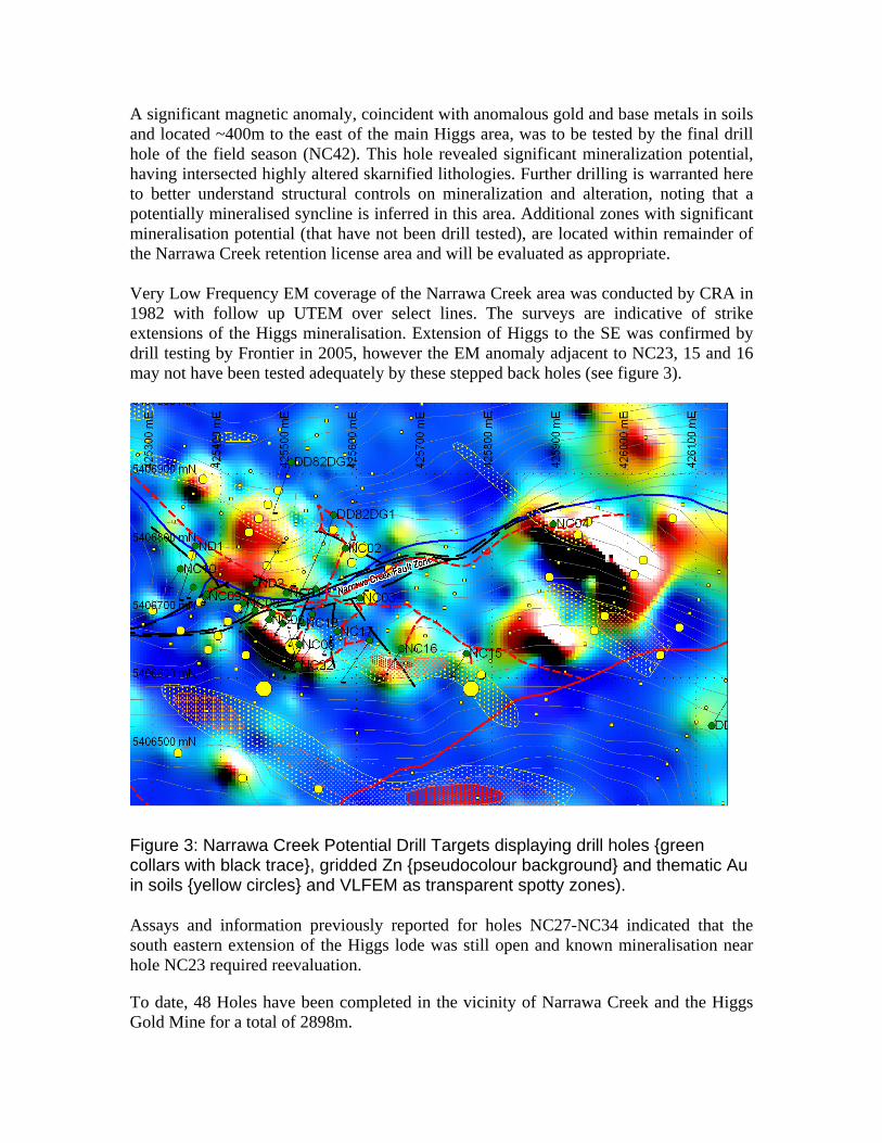
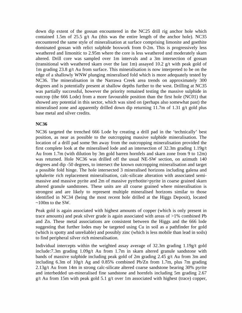
A significant magnetic anomaly, coincident with anomalous gold and base metals in soils and located ~400m to the east of the main Higgs area, was to be tested by the final drill hole of the field season (NC42). This hole revealed significant mineralization potential, having intersected highly altered skarnified lithologies. Further drilling is warranted here to better understand structural controls on mineralization and alteration, noting that a potentially mineralised syncline is inferred in this area. Additional zones with significant mineralisation potential (that have not been drill tested), are located within remainder of the Narrawa Creek retention license area and will be evaluated as appropriate. Very Low Frequency EM coverage of the Narrawa Creek area was conducted by CRA in 1982 with follow up UTEM over select lines. The surveys are indicative of strike extensions of the Higgs mineralisation. Extension of Higgs to the SE was confirmed by drill testing by Frontier in 2005, however the EM anomaly adjacent to NC23, 15 and 16 may not have been tested adequately by these stepped back holes (see figure 3).
Figure 3: Narrawa Creek Potential Drill Targets displaying drill holes {green collars with black trace}, gridded Zn {pseudocolour background} and thematic Au in soils {yellow circles} and VLFEM as transparent spotty zones). Assays and information previously reported for holes NC27-NC34 indicated that the south eastern extension of the Higgs lode was still open and known mineralisation near hole NC23 required reevaluation.
To date, 48 Holes have been completed in the vicinity of Narrawa Creek and the Higgs Gold Mine for a total of 2898m.

Further Outstanding targets
• West Higgs where channel sampling returned values to 58.67g/t Au. This area is poorly understood with three drill holes passing beneath the workings returning little. However potential exists in light of recent advances in geological understanding to delineate resources by more appropriate drill targeting.
• Packetts and West Packetts line of lodes. This area historically produced gold and tungsten and is coincident with a strong magnetic and electromagnetic line of anomalies.
• Potential for greisen related Sn, W and Mo mineralisation exists, particularly in the Narrawa Creek area, but is not a primary focus of this report.
The target size for mineralisation at Narrawa Creek is 0.5-2Mt, suggested forward work program includes:
• Re-sampling massive pyrrhotite bearing drill core eg: NC34 and NC23 where nuggetty gold occurs. Au analysis returned lower than expected gold results for this zone of mineralisation. • Depth modelling of geophysical conductors • Drilling in April/March 2008

References Castro, C. H., and Fleming, M. J., 1989. EL 8/88 Lorinna and EL 36/88 Round
Mountain, Annual Report. RGC Exploration Pty Limited. Tasmanian Company Report (TCR 89-3038)
Jennings, I.B., 1979, Sheffield. Explanatory Report, 1 Mile Map Series, Geol. Surv., Tas. Dept. of Mines
Morrison, K. C., Reed, A. R., and Turner, N. J., 2003. The Dolcoath Granite: A Gold
Exploration Target. Western Tasmanian Regional Minerals Program, Devonian Granite Aureoles Project, Tasmanian Geological Survey Record 2003/16.
Purvis, J. G., 2000. Second Progress Report – Dolcoath EL 37/97. J. G. Purvis and Associated Proprietary Ltd.; Jervois, Tasmanian Company Report (TCR 00_4423).
Reid, A McIntosh, 1919. The Mining Fields of Moina, Mt Claude and Lorinna,
Geological Survey Bulletin No.29. Reid, R.O., and Campbell, A, 2005. EL29/2003 – Gowrie Park Retention License
Application October 24, 2005. Tasmanian Company Report.
Reid, R.O., and McDougall, J, 2004. EL29/2003 – Gowrie Park Annual Report to December 2004; TasGold Ltd. Tasmanian Company Report.
Reid, R.O., and McDougall, J, 2005. EL29/2003 – Gowrie Park Annual Report to
September 23rd 2005; TasGold Ltd. Tasmanian Company Report.