river tees guidance notes - canal & river trust · the barrage reach area is defined as the...
TRANSCRIPT

River Tees Guidance Notes
Date March 2017
Issue 00.01
Contents
1. Amendment Record
2. Introduction
3. Purpose of this Document
4. River Activities
5. River Events
6. River Access
7. Slipways & Launching
8. Barrage Reach Area & Speed Limits – Bye Laws and regulations
9. Barrage Navigation Lock
10. Weather Conditions
11. Bridges
12. Contact Details – Clubs Organisations and Statutory Bodies
13. Safety Equipment
14. Emergencies Accidents & Near Misses
15. Cancelling or Postponing River Events & Activities
Appendix
1. River Hazard Plans and Legend (to follow)
2. Generic hazard Information
3. Vessel registration
4. Barrage Reach Timetable
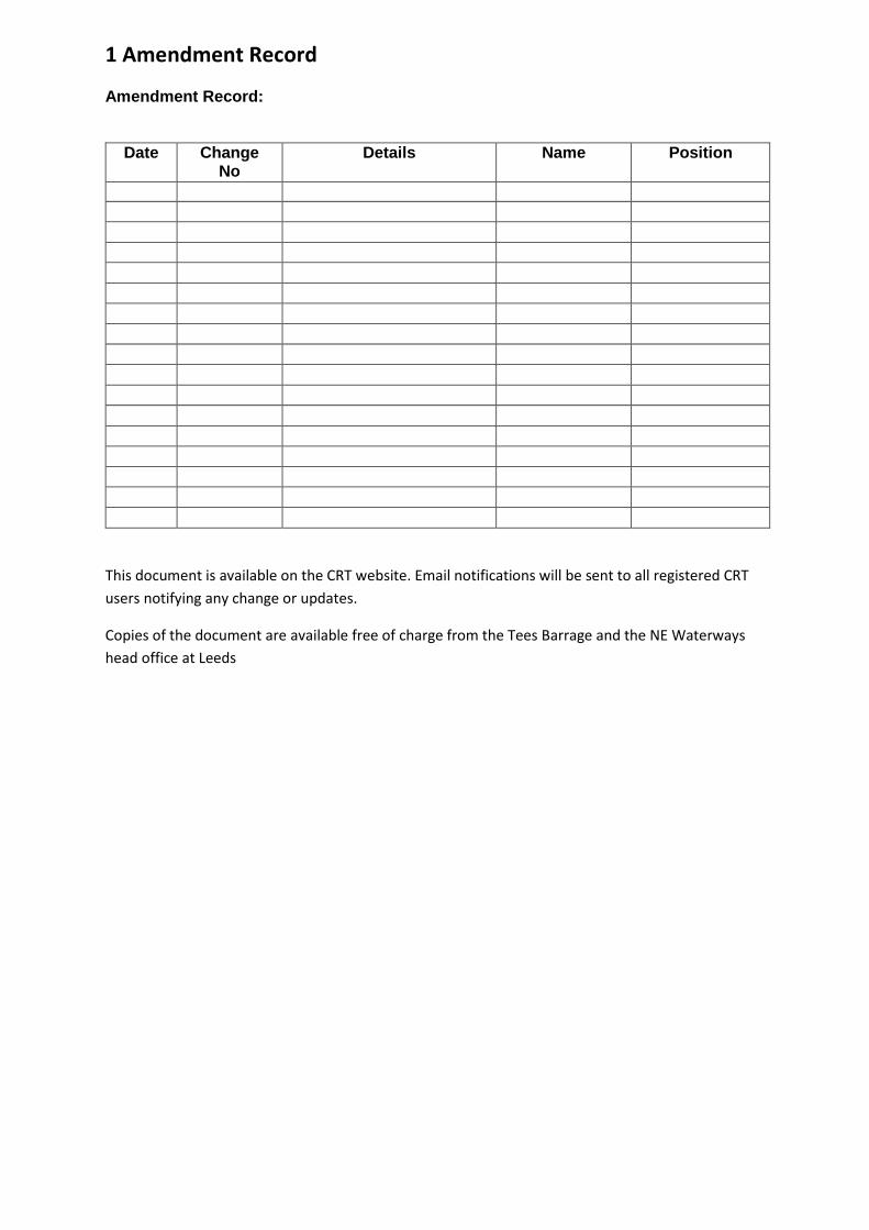
1 Amendment Record
Amendment Record:
Date Change No
Details Name Position
This document is available on the CRT website. Email notifications will be sent to all registered CRT
users notifying any change or updates.
Copies of the document are available free of charge from the Tees Barrage and the NE Waterways
head office at Leeds
2 Introduction Canal & River Trust (CRT) are the navigation authority for the River Tees from a point 200m
downstream of the tidal barrage at Stockton on Tees to the extent of the tidal reach a point
approximately 200m upstream of Holme Farm at Low Worsall, a total distance of approximately
22Km.
The river is used by a variety of users including:-
Commercial passenger boats,
Leisure craft - powered and unpowered.
Smaller craft involved in various river events and activities.
Water Skiing
Jet Skiing
Athletes in unpowered boats training for local, national and international competition
Angling, walking and other land based activities
Canal & River Trust (CRT) maintenance vessels also operate at various locations on the river
The stretch of water from Low Worsall to the end of the tidal reach may not be suitable for
navigation by larger powered craft.
Canal & River Trust have joint responsibilities for the ornamental canals which run from a point
100m downstream of Princess Diana Bridge to a point 250m downstream of Victoria Bridge covering
a distance of approximately 1.1km. The ornamental canals are not navigable and CRT’s
responsibilities are limited to that of land owner only. Some sections of the ornamental canals are
managed by adjoining third party land owners.
In addition to the ornamental canals CRT also have responsibility for the river basins located on the
south side of the river in Stockton on Tees. The basins are not navigable. Barclay Basin is used for
canoe polo.
Tees and Hartlepool Port Authority are the navigation authority downstream of the barrage. The
river at the upstream extent of CRT jurisdiction is managed by the Environment Agency and is not
classed as navigable river. Flood control is managed by the Environment Agency.
In addition to the River Tees, Canal & River Trust are also entrusted with the care of 2,000 miles of
waterways in England and Wales. If you would like more information about the work we do,
volunteering or making a donation please visit www.canal&rivertrust.org.uk
3 Purpose of this Document This document is intended to provide general safety information and practical information for all
river users.
This document has been prepared in close collaboration of the River Tees User Group (RUG). The
River Users Group is facilitated by Stockton Borough Council and is comprised of statutory bodies'
key community partners and river users who all share a set of primary aims and objectives.
It should be noted that Canal & River Trust are the navigation authority only and are unlikely to own
the river banks.

This document only covers land or water where Canal & River Trust have a direct responsibility. Any
person planning any activity on the river bank or adjoining land should ensure they have permission
from the appropriate land owner.
4 River Activities River activities can be divided in to two very broad categories
1. Amateur clubs and societies
2. Professional businesses
1. Amateur Clubs & Societies
Many activities take place on the river which are organised through clubs affiliated to governing
bodies including for example the British Rowing or the British Dragon Boat Racing Association. These
governing bodies often produce their own guidelines and best practices and in some instances
mandatory procedures for their members. CRT recommends that all activities are undertaken in
compliance with their governing bodies’ guidance and instructions.
Any club or society based on or using the river are asked to complete a CRT River Tees Activity
contact and Information Form. The following information will be required.
Primary contact details for the club
Nature of activity
Broad description of the location where the activity takes place - this could be at a specific
location or anywhere on the river.
A broad description of the times that the activity takes place – this could be a pre-set times
or at any time.
Copies of club safety management systems
Confirmation of club insurance
Providing the above information…
Enables CRT to monitor and manage river usage.
Enables CRT to maintain up to date contact details for all clubs and societies using the river
Enables CRT to pass on information to other river users about river activities. This is
particularly important for occasional visitors and new river users
Enables CRT to pass on information about any club activities to other river users.
All clubs and societies are asked to complete a CRT River Tees Activity contact and information form
for all activities undertaken on the river. This is particularly important for activities taking place on
the barrage reach area. Activity contact and information forms are available by contacting Canal &
River Trust North East Waterways.
2 Professional Businesses
There are a number of businesses operating on the river ranging from passenger vessel operations
to small boat hire. Details of this type of activity are managed by the Canal & River Trust business
boat licence teams. Details of such activities have been included in this document.

5 River Events
Canal & River Trust waterways provide great opportunities for a wide variety of events. Any event
organiser considering holding an event on CRT waters should visit the following link for further
details https://canalrivertrust.org.uk/planning-an-event/step-one-event-application-form
All events on CRT NE waters are administered by Unlimited Communications. Event organisers
planning an event on CRT River Tees should contact Unlimited Communications Ltd for an event
application pack or visit the above CRT link. Unlimited Communications can be contacted by email
[email protected] or by telephone by calling 01327 871701.
It may on occasion be necessary to close sections of the river for some events. Where this is the case
provision will be made for craft to moor at the navigation lock before or during the event to allow
uninterrupted access to the river downstream of the barrage.
Please note event organisers should where possible give no less than two months notification of any
event.

6 River Access
A feature of any safety management system associated with river activities will be access to and
from to the water. This section aims to provide generic details of the types of river bank that river
users can expect to come across.
Any person planning river activities should familiarise themselves with the types of river bank and
bank protection that they are likely to come across. It is the responsibility of all those involved in the
activity to ensure they have sufficient and adequate means of access to and from the river in all
eventualities, including emergency situations.
To help assess access to and from the river the following photographs and descriptions have been
included. The following descriptions illustrate typical examples of the types of river bank and bank
protection that river users can expect to come across. The following information is intended as a
general guide only; types of river bank will vary.
Type 1 - Vertical Wall Over 1.0m High with Fencing (under CRT management)
Type 2 - Vertical Wall Over 1.0m High with Fencing (3rd Party)
Description - Usually steel piling with anti-
climb fence above. Ladders are available at
various locations with access through the
fence. Some ladders do not extend far below
normal water level.
Location – This type of bank protection can
be found in Stockton on the left bank
heading upstream
Description - Various types of wall
construction with occasional fencing above.
Ladders intended for emergency egress only
access may be difficult, condition of ladders
and fencing unknown.
Location – This type of bank protection can
be expected in built up areas particularly on
the right bank heading upstream through
Stockton on Tees

Type 3 - Sloping Earth/Stone Banks
Type 4 Unprotected Earth Banks
Description - Earth banks with no official exit
points. Egress possible but may be difficult
with overgrown vegetation and river debris.
Location – This type of river bank is typical of
that found from the barrage up to Stockton
on Tees
Description - Unprotected earth banks no
official exit points. Egress may be possible
but likely to be difficult. Tall grass or other
dense vegetation may be present. Banks will
be slippery and in places steep.
Location – This type of river bank should be
expected in rural areas.
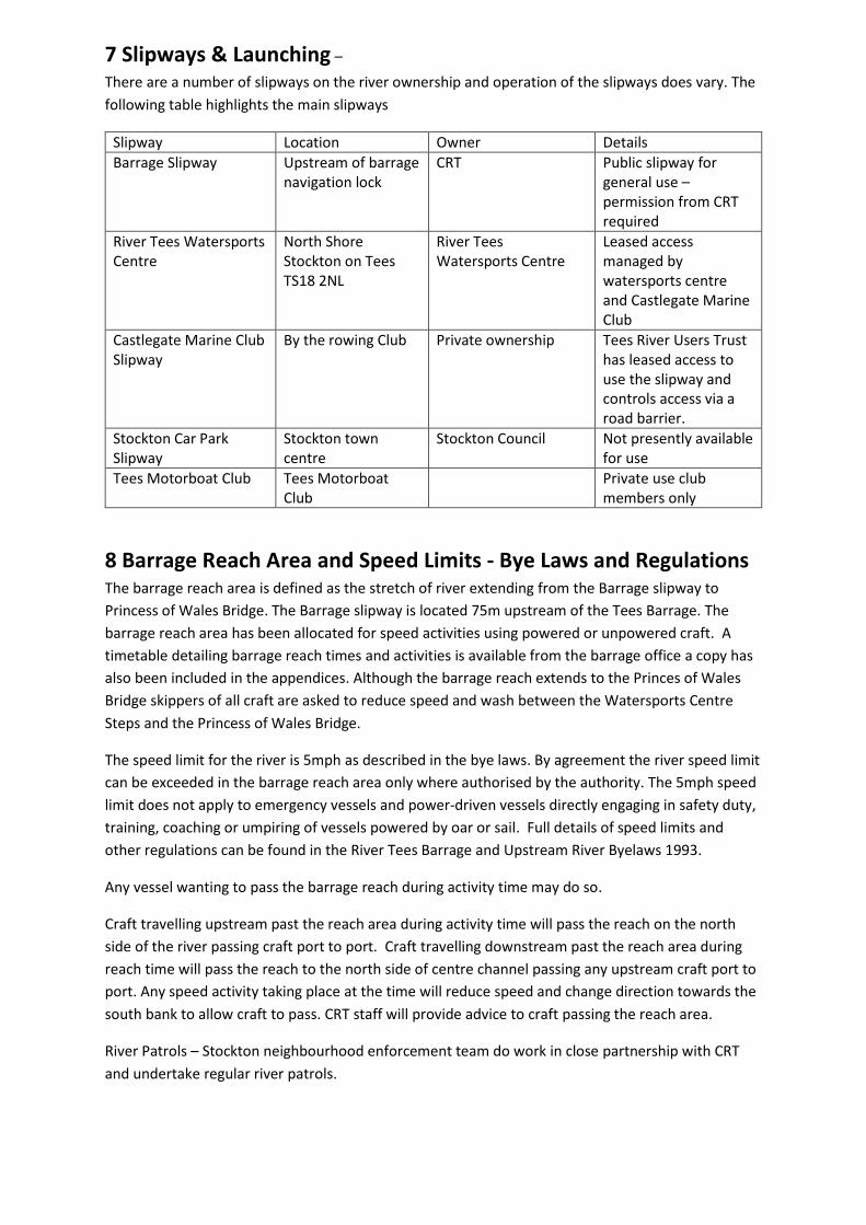
7 Slipways & Launching –
There are a number of slipways on the river ownership and operation of the slipways does vary. The
following table highlights the main slipways
Slipway Location Owner Details
Barrage Slipway Upstream of barrage navigation lock
CRT Public slipway for general use – permission from CRT required
River Tees Watersports Centre
North Shore Stockton on Tees TS18 2NL
River Tees Watersports Centre
Leased access managed by watersports centre and Castlegate Marine Club
Castlegate Marine Club Slipway
By the rowing Club Private ownership Tees River Users Trust has leased access to use the slipway and controls access via a road barrier.
Stockton Car Park Slipway
Stockton town centre
Stockton Council Not presently available for use
Tees Motorboat Club Tees Motorboat Club
Private use club members only
8 Barrage Reach Area and Speed Limits - Bye Laws and Regulations The barrage reach area is defined as the stretch of river extending from the Barrage slipway to
Princess of Wales Bridge. The Barrage slipway is located 75m upstream of the Tees Barrage. The
barrage reach area has been allocated for speed activities using powered or unpowered craft. A
timetable detailing barrage reach times and activities is available from the barrage office a copy has
also been included in the appendices. Although the barrage reach extends to the Princes of Wales
Bridge skippers of all craft are asked to reduce speed and wash between the Watersports Centre
Steps and the Princess of Wales Bridge.
The speed limit for the river is 5mph as described in the bye laws. By agreement the river speed limit
can be exceeded in the barrage reach area only where authorised by the authority. The 5mph speed
limit does not apply to emergency vessels and power-driven vessels directly engaging in safety duty,
training, coaching or umpiring of vessels powered by oar or sail. Full details of speed limits and
other regulations can be found in the River Tees Barrage and Upstream River Byelaws 1993.
Any vessel wanting to pass the barrage reach during activity time may do so.
Craft travelling upstream past the reach area during activity time will pass the reach on the north
side of the river passing craft port to port. Craft travelling downstream past the reach area during
reach time will pass the reach to the north side of centre channel passing any upstream craft port to
port. Any speed activity taking place at the time will reduce speed and change direction towards the
south bank to allow craft to pass. CRT staff will provide advice to craft passing the reach area.
River Patrols – Stockton neighbourhood enforcement team do work in close partnership with CRT
and undertake regular river patrols.

9 Barrage Navigation Lock The navigation lock at the Tees Barrage allows passage between the impounded river and tidal water
downstream. The lock is manned 24 hours per day. Passage through the lock is however limited by
tidal conditions. At low tide there will not be sufficient water to pass the lock cill. On high spring
tides passage is not possible for periods of up to 1 hour each side of high water. The lock may be
unavailable at times of high river flows.
Skippers of all craft should not enter the lock or lock approaches unless the green lights are showing.
The barrage lock keeper will be able to give advice on lock availability and passage times.
10 Weather Conditions Weather conditions can change quickly effecting river conditions. This applies especially to river
levels during or following periods of heavy rainfall. Details of river flows and water levels are
available by contacting CRT staff at the Tees Barrage.
It is the responsibility of the river user to check weather conditions and to take appropriate actions
before undertaking any river based activity.
11 Bridges Several bridges cross the River Tees throughout CRT’s jurisdiction including road and footbridges.
Although the bridges are unlikely to have any impact on leisure activities, all river users should be
aware of the following:-
Bridge headroom will vary with fluctuating river levels. The published maximum air draft for
any craft on the river is 5.5m from mean high water level. Any vessel close to in excess of
this should contact the Tees Barrage for further information.
Un-authorised swimming and anti social behaviour may occur at or close to bridges
The navigable channel is generally mid position through the centre bridge arches
Some bridges can be particularly susceptible to debris build-up
12 Contact Details The following tables provides contact details of clubs professional organisations and statutory bodies
operating on the river.
Club- User Name
Activity Email/website/Address Telephone
Canal & River Trust
Yarm School Private river activities
Teesside Motorboat Club
Motor Boats
Castlegate Motorboat Club
Motor Boats
River Tees Watersport Centre
Various water sport activities
River Tees Watersports Centre, North Shore, Stockton on Tees TS18 2NL

Tees Tigers Canoe Club
Water Polo & kayaking
www.teestigers.com
Tees Rowing Club
Rowing [email protected]
Powerhouse Dragon Boat Racing Club
Dragon Boat Events
www.powerhousedragons.co.uk 01642 814052
Water Ski School
01642 595604
Tees Wheelyboats
info@tees–wheelyboats.org.uk 07748 908646
Stockton Council River User Group
Stockton Neighbourhood Enforcement Team
01642 528439
RiverShack Rowing Boat Hire
[email protected] 07795 613299
Durham University
Rowing Club www.durham.ac.uk/teamdurham
Tees Barrage Upstream Sailing Association
[email protected] 07429 172288
Tees Personal Watercraft Club
John Snow College Boat Club
Teesside University Boat Club
Stephenson College Boat Club
Angling Clubs
Organisation Enquiry Contact
Emergency Services Accident or Incident 999
Canal & River Trust General Enquiries and operational emergencies
01642 633273
Environment Agency Incident hotline 0800 80 70 60
Environment Agency General Enquiries Tel. 03708 506 506 [email protected] Minicom (for the hard of hearing) 03702 422 549
13 Safety Equipment Canal & River Trust do install and maintain safety equipment on waterside land within its ownership.
Although Canal & River Trust does have a regular regime for maintaining life buoys and other safety
equipment within its ownership the life buoys are subject to regular vandalism. Sadly for this reason
the presence of life buoys should not be relied upon. The following list details the types of safety
equipment managed by Canal & River Trust.
Life buoys
Grab chains
Ladders
Other safety equipment may be found on land outside CRT ownership, where this is the case that
equipment will be the responsibility of the appropriate third party land owner.
14 Emergencies Accidents & Near Misses All emergencies on the river should in the first instance be reported to the emergency services by
dialling 999.
Although Canal & River Trust are not an emergency service they will always assist with an emergency
where it is right and safe to do so.
In order for CRT to monitor incidents on the river all river users are asked to report all near misses,
unsafe practices and accidents to the CRT at the Tees Barrage. Monitoring incidents on the river will
allow CRT to identify any trends and help prevent accidents and incidents.
An online visitor incident report form can be obtained from any CRT office or by visiting the CRT web
site by the following link https://canalrivertrust.org.uk/contact-us/visitor-incidents
Any reports of river pollution should be reported to the Environment Agency using the contact
details listed in section 12 of this document.
15 Cancelling or Postponing River Events and Activities It may from time to time be necessary for Canal & River Trust to cancel or postpone an activity or
event or to close the river or sections of river. Reasons for postponing an activity or event or closing
the river could include but would not be limited to the following:-
Flood event
High river flows
Pollution incident
Emergency services operation
Engineering works
Canal & River Trust will always give as much notification as possible when it becomes necessary to
cancel or postpone an activity or event, depending on circumstances notification times could be
short.

Appendices
1 Generic Navigational Hazard Information
2 Barrage reach times

Appendix 1 General Navigational Hazard Information
Known Navigational & Riverside Hazards - Tees Barrage to Worsall Canal & River Trust North East Waterways have prepared the following two lists of know hazards. The purpose of the two lists is to assist river users produce their safety management systems. The hazards listed in the tables relate to general navigational hazards and other hazards that may be encountered on or close to the river banks or the ornamental canals. Although every effort has been made to include all hazards known to Canal & River Trust other hazards may exist on or close to the river. It should be noted that on river sections Canal & River Trust are generally the navigation authority only and are unlikely to own the river banks. Before any work or activity takes place on the river banks permission should therefore be sought from the appropriate landowner. Hazards included on the following two lists do not include hazards associated with specialist activities. Event organisers are advised to include in their safety management systems suitable control measures for:-
1. Navigational and or waterside hazards listed on the following tables plus any other hazards they consider appropriate.
2. Any hazards specific to specialist activities that maybe undertaken. Any queries regarding the following known hazards should be referred to Canal & River Trust River Tees River Master. Table of Know Navigational Hazards
Hazard Details
Flowing Water
The river does flow. Flows can be fast and unpredictable particularly after rainfall.
Automated Machinery The river level is controlled by the barrage. Barrage operation is automated and can operate without warning. The lock gates at the barrage are automated and are operated by BW staff from the barrage control room.
Silt Deep silt may be present on the river bed.
Deep Water
The water is deep in places and generally greater than standing depth.
Poor Water Visibility
Visibility below water will be limited.
Debris
Debris maybe present on and below the water surface.
Underwater Obstructions
Underwater obstructions maybe present creating potential for underwater entrapment and injury.
Biological Contamination
Leptospirosis and contaminated sharps and other waterborne pathogens maybe present.
Falling Objects
Objects maybe thrown or fall from bridges.
Slips Trips & Falls
The river banks in places are steep and uneven, access may be difficult.
Vessel Movements
Various vessels use the river including powered and unpowered craft. Large passenger vessels also use the river.

Anti Social Behaviour Anti social behaviour may be experienced at various along the river and associated structures.
Limited sight lines In places sight lines can be restricted particularly at bridges and close to moorings.
Vegetation In places vegetation may overhang the canal or river. Overhanging vegetation can restrict access and egress from the river/canal and restrict sight lines.
Swimming Unauthorised swimming does occur on occasions this is a particular problem in the summer months.
Bridges Restricted headroom or reduced headroom at time of flood.
Golf Balls Golf balls can enter the at the golf courses between the pipe bridge and Preston Park and at Eaglescliffe
Table of Know Waterside Hazards
Hazard Details
The River
The river is deep and is subject to fast flows particularly following heavy rainfall. In places the river banks are formed from high walls or steep sloping banks where egress from the river is not possible.
Slips Trips & Falls The surfaces on the river banks do vary in type and condition. In places the river bank paths are unsurfaced and uneven. Potholes can be expected particularly in the rural areas.
Falling Objects Objects can be dropped or thrown from bridges.
Biological Contamination Leptospirosis contaminated sharps and other waterborne pathogens maybe present in or close to the water.
Other Users Various users use the river paths and bridges including walkers runners and cyclists
Anti Social Behaviour Anti Social behaviour maybe present experienced on the river banks
Tees Barrage The barrage is an automated structure than can operate without warning. Fencing is situated around the structure restricting access to unauthorised areas
Towpath and riverside vegetation Invasive and toxic plants including Giant Hogweed may be found on canal and river banks. Vegetation over hanging towpaths may be a problem particularly in rural areas.
Locks Lock chambers do not have fenced edge protection, the water is deep, access and egress from locks is via lock ladders.
Weirs Weirs can be high with vertical faces, water flows below weirs will be turbulent.
July 2013

Appendix 2