river habitat survey in the picos de europa ...core.ac.uk/download/pdf/61083.pdfriver habitat survey...
TRANSCRIPT

RIVER HABITAT SURVEY IN THE PICOS DE EUROPA,
NORTHERN SPAINR E S U L T S F R O M 2 0 0 8
January 2009
A report by Paul Raven1, Nigel Holmes2, Peter Scarlett3, Mike Furse3 and José Barqúin Ortiz4
1 Head of Conservation and Ecology, Environment Agency.2 Alconbury Environmental Consultants – Environment Agency external technical adviser for conservation.
3 NERC – Centre for Ecology and Hydrology. 4 Instituto de Hidráulica Ambiental, IH Cantabria.

i
Purpose. 1
Background to methods. 1
Survey and assessment. 3
Results. 4
Discussion. 10
Conclusions. 14
Appendix 1: Notes for Picos-1 to Picos-20. 16
Appendix 2: Recommendations for improving 24the RHS manual.
Annex A: Characteristics of the rivers surveyed. 26
Annex B: River catchment geology. 26
Annex C: Maps showing Picos-1 to Picos-20. 27
Annex D: Water chemistry. 29
Annex E: HQA sub-scores and total scores 29for Picos-1 to Picos-20.
Annex F: HMS and habitat modification 29class for Picos-1 to Picos-20.
Annex G: MTR survey results. 30
Annex H: JNCC macrophyte survey results. 31
Annex I: Selected habitat features and 33ad hoc observations of wildlife.
CONTENTS
REFERENCES1. Environment Agency (2003). River Habitat Survey in Britain and Ireland. Field
Survey Guidance Manual: 2003. Bristol.2. Holmes, N T H, Boon, P J and Rowell, T A (1999). Vegetation Communities
of British Rivers: A Revised Classification. Joint Nature ConservationCommittee, Peterborough.
3. Holmes, N T H, Newman, J R, Chadd, S, Rouen, K J, Saint, L and Dawson, FH (1999). Mean Trophic Rank: A User’s Manual. R&D Technical Report E38,Environment Agency, Bristol.
4. Furse, M T, Hering, D, Brabec, K, Buffagni, A, Sandin, L and Verdonschot, P FM (Eds) (2006). The Ecological Status of European Rivers: Evaluation andIntercalibration of Assessment Methods. Hydrobiologia, 566: 1-555.
5. CEN (draft – unpublished). Water quality – guidance standard ondetermining the degree of modification of river hydromorphology.
6. Furse, M T, Tapia, G, Lemmey, R, Prince, H, and Dyke, N (unpublished). Anassessment of the ecological quality of the rivers of the Camaleño Valley,Picos de Europa, and the relationship between the distribution ofmacroinvertebrate taxa and landscape and land cover features. Projectreport.
7. Agricultural University of Poznań (2007). Hydromorfologiczna Ocena WódPłynących (River Habitat Survey Manual). Poznań, Poland.
8. Raven, P J, Holmes, N T H, Dawson, F H, Fox, P J A, Everard, M, Fozzard, Iand Rouen, K J (1998). River Habitat Quality: the Physical Character of Riversand Streams in the UK and the Isle of Man. Environment Agency, Bristol.
9. Jeffers, J N R (1998). Characterisation of river habitats and prediction ofhabitat features using ordination techniques. Aquatic Conservation, Marineand Freshwater Ecosystems, 8, 529-540.
10. Vaughan, I P (in press). Habitat indices for rivers: derivation and applications.Aquatic Conservation, Marine and Freshwater Ecosystems, Special Issue.
11. Vaughan, I P, Noble, D G and Ormerod, S J (2007). Combining surveys ofriver habitats and river birds to appraise riverine hydromorphology.Freshwater Biology, 52, 2270-2284.
12. Walker, J, Diamond, M and Naura, M (2002). The development of physicalquality objectives for rivers in England and Wales. Aquatic Conservation,Marine and Freshwater Ecosystems, 12, 381-390.
13. Raven, P J, Holmes, N T H, Charrier, P, Dawson, F H, Naura, M and Boon, P J(2002). Towards a harmonised approach for hydromorphological assessmentof rives in Europe: a qualitative comparison of three survey methods.Aquatic Conservation, Marine and Freshwater Ecosystems, 12, 477-500.
14. Raven, P J, Holmes, N T H, Dawson, F H and Everard, M (1998). Qualityassessment using River Habitat Survey data. Aquatic Conservation, Marineand Freshwater Ecosystems, 8, 405-424.
15. CEN (2004). Water quality: guidance standard for assessing thehydromorphological features of rivers. EN 14614: 2004. EuropeanCommittee for Standardisation.
16. Raven, P J, Holmes, N T H, Dawson, F H, and Withrington, D (2005). RiverHabitat Survey in Slovenia. Results from 2005. Environment Agency, Bristol.
17. Raven, P J, Holmes, N T H, Dawson, F H, Binder, W and Mühlmann H(2007). River Habitat Survey in Southern Bavaria and the Tyrolean Alps.Results from 2006. Environment Agency, Bristol.
18. Raven, P J, Holmes, N T H, and Dawson, F H (2007). River Habitat Survey inthe Ardèches and Cévennes areas of South-eastern France. Results from2007. Environment Agency, Bristol.
19. Raven, P J, Holmes, N T H, Scarlett, P, Szoszkiewicz, K, Ławniczak, A andDawson, F H (2008). River Habitat and Macrophyte Surveys in Poland.Results from 2003 and 2007. Environment Agency, Bristol.
20. Vasson, J-G, Candesris, A, Garcia-Bautista, A, Pella, H and Vaileneuve, B(2006). Combined pressures and geographical context: hydro-ecoregionsframework. Cemagref. REBECCA project report; produced for FinnishEnvironment Ministry. 40pp.
21. de la Hoz, M A (co-ordinator) (2005). Visitor’s guide to Picos de EuropaNational Park. Organismo Autónomo Parques Nacionales.
22. Alba-Tercedor, J and Sánchez-Ortega, A (1998). Un método rápido y simplepara evaluar la calidad biológica de las aguas Corrientes basado en el deHellawell (1978). Limnética, 4, 51-56.
23. Clarke, R T, Furse, M T, Wright, J F and Moss, D (1996). Derivation of abiological quality index for river sites: comparison of the observed andexpected fauna. Journal of Applied Statistics, 23, 311-332.
24. LAWA (2000). Gewässerstrukturgütebewertung in der BundesrepublikDeutschland, Verfahren für kleine und mittlegroße Fließgewässer, Berlin.
25. Orr, H, Large, A R G, Newson, M D and Walsh, C L (2008). A predictivetypology for characterising hydromorphology. Geomorphology, 100, 32-40.
26. Hughes, S J, Fereira, T, and Cortes, R V (2008). Hierarchical spatial patternsand drivers of change in benthic macroinvertebrate communities in anintermittent Mediterranean river. Aquatic Conservation, Marine andFreshwater Ecosystems, 18, 742-760.
27. Cortes, R M V, de Oliveira, S V, Hughes, S J and Ferreira, M T (2008).Combining habitat and biological characterization: ecological validation ofthe river habitat survey. Limnetica, 27, 39-56.
WEB SITESGoogle Earth: http://earth.google.com/index.htmlLife in UK Rivers: www.riverlife.org.ukPicos de Europa National Park:http://reddeparquesnacionales.mma.es/parques/picosREBECCA project: www.environment.fi RHS: [email protected]: www.eu-star.atWISE: http://www.eea.europa.eu/themes/water
GLOSSARY OF ACRONYMS ASPT Average Score per TaxonBMWP Biological Monitoring Working PartyCEH Centre for Ecology and HydrologyCEN Committee for StandardisationGPS Global Positioning SystemHEP Hydro-Electric Power
HER Hydro-ecological RegionHMC Habitat Modification ClassHMS Habitat Modification ScoreHQA Habitat Quality AssessmentJNCC Joint Nature Conservation CommitteeLAWA Länderarbeitsgemeinschaft Wasser
(German National Association of Water)MTR Mean Trophic RankNTAXA Number of Scoring (macroinvertebrate) TaxaPCA Principal Component AnalysisPicos-1, Reference code to identify individual sites etc. surveyed in the PicosREBECCA Relationships between ecological and
chemicals status of surface watersRHS River Habitat SurveySTR Species Trophic RankSTAR STAndardisation of River ClassificationsWFD Water Framework DirectiveWISE Water Information System in Europe

1
PURPOSEThe purpose of our visit (1-8 June 2008) was to test RiverHabitat Survey (RHS) and macrophyte surveys on aselection of rivers in the Picos de Europa and to provideadvice on an effective sampling and training strategy forRHS in the Cantabrian Region of Spain.
Specific objectives were to:
• Locate and survey a selection of rivers using RHS1,plus the Joint Nature Conservation Committee(JNCC)2 and Mean Trophic Ranking (MTR)3
macrophyte survey methods.
• Collect RHS and macrophyte data for Europeaninter-calibration purposes and add them to thedatabases already established for theStandardisation of River Classifications (STAR)project4.
• Generate data for testing and refining the draftCEN guidance standard on thehydromorphological assessment of rivers5.
• Recommend improvements to the RHS guidancemanual for use on European rivers, in particulartaking account of local characteristics found innorthern Spain.
• Support training, quality assurance and databasedevelopment needs for subsequent RHS surveywork in the Cantabrian Region.
• Make a direct link to biological water qualityresults from previous project work in the upperreaches of the Río Deva catchment6.
We have also included some recommendations arisingfrom a subsequent visit to the Drawa River in Poland (lateAugust 2008), because they are relevant to lowland riversin the wet temperate areas of Northern Spain.
BACKGROUND TO METHODSRiver Habitat SurveyRiver Habitat Survey is a method developed in the UK tocharacterise and assess, in broad simple terms, the physicalcharacter of freshwater streams and rivers. It is carried outalong a standard 500m length of river. Observations onchannel features and modifications are made at 10 equallyspaced spot-checks, together with an overall “sweep-up”summary for the whole site. Other information such asvalley form and land use in the river corridor is alsocollected. Field survey follows the strict protocols given inthe 2003 RHS Manual1 and surveyors in the UK are fullytrained and accredited.
RHS has been carried out in several European countries: forinstance, more than 200 RHS surveys were included in theSTAR project4; 200 sites have been surveyed in Portugal;more than 600 in Poland, and a further 400 will besurveyed during 2008-9 in the Cantabrian Region ofnorthern Spain. Portugal has recently decided to adoptRHS as a method for its Water Framework Directive (WFD)work. The RHS Manual1 has been adapted and translatedinto Italian, French and Polish7, whilst a Portuguese versionis also being developed.
RHS survey data and site photographs are entered onto acomputer database. The UK database now contains fieldobservations, map-derived information and photographsfrom more than 20,000 surveys undertaken since 1994.During 1994-96, a stratified random network of nearly5000 sites established a geographically representativebaseline cross-section of streams and rivers across the UK8.A second stratified random survey, to establish trends inriver habitat quality across England and Wales since theinitial baseline, has been carried out during 2007 and2008.
The RHS database allows sites of a similar nature to begrouped together for comparative purposes. Slope,distance from source, height of source and site altitude areused to cluster RHS sample sites for so-called “contextanalysis” based on Principal Component Analysis (PCA)plots9. A more sophisticated context analysis, using fieldsurvey data to derive seven indices of river character is nowin its final stage of development and testing10.
The database allows detailed investigation into therelationship between physical variables (e.g. bedslope,land-use), channel modifications and habitat features atspot-check and site level. These investigations can makelinks with water chemistry and hydrological data, plusaquatic macroinvertebrate, macrophyte, fish or breedingbird survey results where additional sampling has beendone in or near RHS sites11.
Assessment of habitat quality and extent of channelmodification can be derived from RHS data, and theseindices can be used as a basis for setting physical qualityobjectives for rivers12.
The 2007 Polish RHS Manual.
Principal Component Analysis allows comparison of similar river-types based on map data.

2
HHabitat Quality Assessment (HQA) is a broad indicationof overall habitat diversity provided by natural features in thechannel and river corridor. Points are scored for the presenceof features such as point, side and mid-channel bars,eroding cliffs, coarse woody debris, waterfalls, backwatersand floodplain wetlands. Additional points reflect the varietyof channel substratum, flow-types, in-channel vegetation,and also the extent of banktop trees and the extent of near-natural land-use adjacent to the river.
Points are added together to provide the HQA. In contrastto HMS (see below), the higher the score, the more highlyrated the site. The diversity and character of features at anysite is influenced by natural variation and also the extent ofhuman intervention both in the channel and adjacent land.The RHS database allows HQA scores to be compared usingsites with similar physical characteristics (e.g. slope, distancefrom source) and geology. Features determining habitatsuitability for individual species such as European river otterLutra lutra or dipper Cinclus cinclus can also be selected,thereby providing a more sophisticated, species orcommunity-based context for comparing sites13. Carryingout RHS and macrophyte surveys in reaches of known goodor high quality has provided the necessary calibration ofHQA across a wide range of river types in the UK. Thesespecially targeted surveys have been extended to mainlandEurope, including rivers in Finland, Norway, Slovenia,Bavaria, the Tyrolean Alps, the Cévennes in south-easternFrance and Poland. The 2008 surveys in the Picos deEuropa represent a further component in this work, whichnow covers 59 rivers and 106 RHS sites. Comparison ofvarious habitat assessment methods has also been part ofthis European-wide initiative14.
Habitat Modification Score (HMS) is an indication ofartificial modification to river channel morphology. Tocalculate the HMS for a site, points are allocated for thepresence and extent of artificial features such as culvertsand weirs and also modifications caused by the reprofiling
and reinforcement of banks. The more severe themodification, the higher the score. The cumulative pointstotal provides the Habitat Modification Score (HMS). Incontrast to HQA, higher scores reflect more artificialintervention and modification of the river channel withinthe site. A Habitat Modification Class (HMC) has beendeveloped which allocates a site into one of fivemodification classes, based on the total score.
RHS made an important contribution to development ofthe CEN standard “Water quality: guidance standard forassessing the hydromorphological features of rivers (EN14614)”, which was published in 200415. It is arecommended method for the agreed protocol for fieldsurvey and feature recording of morphological data. RHS isalso being used to help develop an associated CENguidance standard on determining the degree ofmodification on river hydromorphology5. In the UK it hasalready been used for WFD purposes to identify referenceconditions, “heavily modified” riverine water bodies andhydromorphological pressures affecting river catchments.
The STAR (STAndardisation of River Classifications)project was a research initiative funded by the EuropeanCommission under the Fifth Framework Programme andwas completed in 2005. A major aim was to providestandard biological assessment methods compatible withWFD requirements. It also aimed to develop a standard fordetermining the class boundaries of ‘ecological status’ andanother one for inter-calibrating existing methods. InAustria, The Czech Republic, Denmark, Germany and Italy‘core’ RHS sites were chosen to reflect a gradient in habitatand morphology degradation. Results from the STARproject were published in a special issue of the journalHydrobiologia in 20064.
Aquatic macrophyte surveysWhen undertaking special RHS and macrophyte surveys onUK and mainland European rivers, two methods arenormally used in tandem. The JNCC method2 recordsaquatic and marginal plants within the same 500m as theRHS survey. Species from the river channel and the watermargins along the base of the bank are recorded separatelyon a three-point scale of abundance. A check-list of speciesis used to aid recording. Data are held on a JNCC database,and field data can be used to classify the plant community2.
The second type is the MTR survey3. This records onlyaquatic taxa, again using a check-list of species, but withina 100m length of river. Each species is assigned a trophicrank of 1-10, depending on its tolerance to eutrophication(1=tolerant; 10=intolerant). Cover abundance of species isestimated on a scale of one to nine and the combination ofcover values and trophic rank enables a MTR score to bederived. This provides an indication of the level of nutrientenrichment of the sites surveyed.
For inter-calibration purposes, methods such as RHS andMTR that have been developed for rivers in the UK need tobe tested and adapted for use elsewhere in Europe wherehydrology, morphology and floristic character may differ.
Artificial reprofiling and reinforcement of thebanks and channel produce a high HMS score.
For JNCC macrophyte surveys, vegetation in thechannel and along the water’s edge is recorded.
For the MTR method, plants growing in the waterare used to calculate scores.
Diversity of natural in-channel, bank and riparian habitat produces a high HQA score; Picos-8.

SURVEY AND ASSESSMENTThe primary purpose of our study was to locate and surveynear-natural examples of rivers to calibrate RHS andmacrophyte results. In Spain many rivers are regulated forhydro-electric power (HEP) and water storage purposes, sothere are very few examples of unmodified rivers in natural“wild wood” or wetland landscapes. We therefore focusedon an area where regulation was not a major impact. Inpreparation for our visit, we used a combination of large-scale maps, Google Earth images, the availability ofmacroinvertebrate data from previous surveys of rivers6 andadvice from the National Park to target our survey onthose rivers that appeared to have near-natural channelform and land-use. Local advice was used to confirm thesuitability of the rivers, whilst the precise location of ourRHS surveys was determined on site. Many potentialreaches were inaccessible because they were located indeep canyons or gorges. In general, our final selectionrepresented near-natural examples that could be surveyedsafely by surveyors working in pairs.
The streams and rivers we surveyed were located in steep,deep, well-wooded valleys, typical of the Picos landscape.Variation was provided by local differences in channelgradient, including variations between adjacent sites onthe same river (Annex A), geology (Annex B) andcatchment land-use. The Río Púron site, (Picos-18), wassurveyed because it had been suggested by local biologistsas a candidate WFD reference condition river for itsgeomorphological processes and features. Visiting this sitewith colleagues from Spain therefore provided a goodopportunity for discussion on quality assessment principles.
River Habitat Survey was undertaken by Paul Raven andPeter Scarlett, working together for quality assurance andhealth and safety reasons. Results are available for all 20 ofthe sites surveyed. Approximate site locations are shownon the back cover map.
Nigel Holmes carried out macrophyte surveys on all therivers visited, using the JNCC and MTR methods at 18 and15 of the RHS sites respectively.
The RHS survey form entries were cross-checked usingdigital photos taken in the field. Background information(e.g. altitude, bedslope, geology), was derived fromvarious map-based and literature sources. Latitude andlongitude readings were obtained using GPS in the field,but some of these were found to be unreliable when cross-checked against 1:25,000 scale maps (Mapa TopografíaNacional de España series), so the map-derived readingshave been used. Topographical maps showing sitelocations appear in Annex C. These clearly demonstratethat deriving bedslope gradient estimates is tricky whensites are located in steep valleys or gorges because thecontour lines are so close together. In addition, there isvariation betweenindividual butadjacent 1:25,000scale maps, inparticular thechannel courseand whether theriver isintermittent.
Basic waterchemistry (pH andconductivity) wasdetermined in
the field by a hand-held meter. Water samples werefiltered, stored and subsequently analysed in the CEHDorset laboratory (Annex D).
As part of a previous study into the relationship betweenthe macro-invertebrate fauna and landscape features in theupper reaches of the Río Deva catchment, biologicalsamples were taken from 44 river reaches in April 19956.At each site a standard one-minute kick/sweep with apond-net was carried out; sampling effort for each in-channel habitat type was in proportion to the area ofstream-bed it occupied. Specimens were hand-picked andpreserved in alcohol for later verification. In addition, alarge array of map-derived and field survey information onhabitat, land cover and other features was collected andanalysed to generate an environmental classification of theRío Deva catchment. For this report, we have selected onlythe biological water quality assessments for the threestreams that we surveyed using RHS.
The weather during survey work was generally good, butwater levels were rather high following prolonged wetweather throughout May and a major rainfall event on 30May that caused flooding in Bilbao. Elevated water levelsand discharge will have distorted the water chemistryresults, pattern of flow types, masked the occurrence ofsome riffles and submerged some depositional featuresnormally exposed during dry-weather flows. However, thegood clarity of the water did not impede visual assessmentof channel substratum, so the potential bias in HQA scoreswas probably small.
Calculation of the RHS indices (HQA and HMS) was doneusing the 2005 version of these systems – in similar fashion tothat done for sites surveyed in Slovenia16, the Bavarian andthe Tyrolean Alps17, the Cévennes18 and Poland19. This meansthat assumptions have had to be made about the inclusionand scoring of special features (see Discussion section).
A complete set of RHS survey forms, a CD-Rom with digitalphotographs, maps showing locations, sketches andmacrophyte lists for each site visited has been producedand are available on request. The notes in Appendix 1appear in Section P of the RHS database entry. Sitenumbers, prefixed with “Picos” are unique codes thatidentify individual survey results in the database.
In total, 20 RHSsites on 10 riverswere surveyed.There were fivesingle (500m)surveys, twopaired surveys(1km), one tripleset (1.5km) andtwo sets of foursurvey units (2km)(Appendix 1). Wecompleted asmany multiplesurveys as wecould to maximiseuse of our timeand also todetermine thevariation innumber and typeof featuresrecorded overdifferent lengths ofriver.
3
Many rivers in Spain are heavily modified and regulated.
Many of the mountain streams flow throughinaccessible ravines and gorges.
4
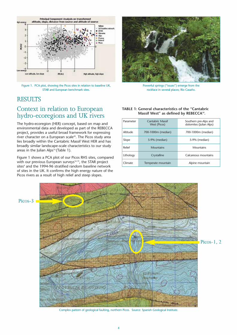
RESULTSContext in relation to Europeanhydro-ecoregions and UK riversThe hydro-ecoregion (HER) concept, based on map andenvironmental data and developed as part of the REBECCAproject, provides a useful broad framework for expressingriver character on a European scale20. The Picos study arealies broadly within the Cantabric Massif West HER and hasbroadly similar landscape-scale characteristics to our studyareas in the Julian Alps16 (Table 1).
Figure 1 shows a PCA plot of our Picos RHS sites, comparedwith our previous European surveys16-19, the STAR projectsites4 and the 1994-96 stratified random baseline networkof sites in the UK. It confirms the high energy nature of thePicos rivers as a result of high relief and steep slopes.
Figure 1. PCA plot, showing the Picos sites in relation to baseline UK, STAR and European benchmark sites.
Powerful springs (“issues”) emerge from the rockface in several places; Río Casaño.
TABLE 1: General characteristics of the “CantabricMassif West” as defined by REBECCA19.
Parameter Cantabric Massif Southern pre-Alps and West (Picos) dolomites (Julian Alps)
Altitude 700-1000m (median) 700-1000m (median)
Slope 5-9% (median) 5-9% (median)
Relief Mountains Mountains
Lithology Crystalline Calcareous mountains
Climate Temperate mountain Alpine mountain
Complex pattern of geological faulting, northern Picos. Source: Spanish Geological Institute.
Picos-3
Picos-1, 2
5
Landscape and river characterThe Picos de Europa is part of the Cantabrian cordilleraand characterised by high mountains and precipitousslopes. The geology comprises predominantlycarboniferous limestones but with outcrops of quartzites,sandstones and conglomerates to the north and the south.There is a very complicated pattern of faults andoverthrusts, whilst the area was extensively glaciated in theQuaternary Period. As a result, there are abrupt changes ingeology, very extensive cave systems (>1000m deep), pluscanyons, gorges, dry valleys, springs and glacial deposits.
Many of the high altitude headwaters are seasonal andsome of our study sites are marked as intermittent on somemaps. The hydrology is extremely complex, with powerfulsprings emerging from several aquifers to feed the riversystems. This makes “distance from source” as a PCAattribute rather meaningless, so channel width as afunction of discharge is probably a much more relevantparameter.
This is the wettest part of Spain, mainly because of theproximity of a high mountain range (peak altitude is2646m) to the Atlantic coast. Snow represents nearly 20%of precipitation on the highest peaks and annualprecipitation can exceed 2000mm. Storms and torrentialrain episodes are not uncommon.
A marked altitudinal series of climatic regions produces awell-developed altitude-related zonation of vegetation.This is reflected by bare alpine peaks, sub-alpine scrub,upper montane beech (Fagus sylvatica) forest and lowermontane oak (Quercus spp.) forest. Below 800m, mixedbroadleaf woodland is dominant, with alders (Alnus
glutinosa), willows (Salix spp.) and ash (Fraxinus excelsior)forming riverine woodland in the valleys.
Meadows grazed by sheep, goats and cattle or managedfor hay are widely distributed up to 1000m. Some parts ofthe National Park are heavily grazed, so many streams,particularly in plateau areas (e.g. Valle del Duje), are devoidof trees. In some places streams have been realigned andembanked to improve the pasture. Outside the NationalPark burning by shepherds, (a widespread practice inAsturias and Cantabria), means that woodland is replacedby heathland in several areas.
Fortunately, herb-rich meadows, the product of traditionalagriculture, are still a characteristic feature of high natureconservation interest in the landscape. The low yielding buthigh quality foodstock crop produces astonishingly species-rich fields, with many types of orchid. The stunninglandscape and exceptional botany attracts thousands ofwalkers and natural history enthusiasts each summer.During the last 20 years, increasing numbers of tourists, (atrend accentuated by a road building programme in valleysthat were previously difficult to reach and also the adventof cheap air travel to Santander), has put pressure on therural landscape and rural communities. Other pressuresinclude an increasing use of artificial fertilisers, hedgerowremoval and the introduction of non-indigenous cattle.
Overall, the landscape, geology and rivers are broadlysimilar to the Julian Alps in Slovenia16. Another similarity isthe general trend of people moving away fromsubsistence-level traditional agriculture to urban life. As aconsequence, many herb-rich meadows are beingconverted to monoculture ley pasture, or simplyabandoned, leading to the encroachment of scrub.
Goat and sheep grazing produces rough pastureland on steep valley slopes and screes; Picos-1.
Heathland produced by burning is widespread inparts of Asturias and Cantabria; near Trescares.
Stunning, orchid-rich meadows attract botanists to the Picos.
Heavily-wooded valleys and alpine peaks characterise the landscape; Río Salvorón valley.
Río Duje near Sotres: far from near-natural riparian conditions.

6
The streams and rivers that flow in canyons, gorges anddeep, steep-sided valleys are all basically of the samebedrock/boulder channel character. The Río Cares has anHEP generation plant at Poncebos, whilst the Río Dobrahas also been dammed to provide power. The threeprincipal rivers in the Picos (Sella, Cares and Deva) are indeep gorges which provide the only access routes formajor roads (see back cover map). These roads are
chiselled out of the rockface, leaving the in-channelstructure below largely intact.
There are several stone-built Roman bridges, whilst theruins of the first HEP station in Spain, located in theCasaño valley 500m downstream from Picos-7, is a featureof more recent historical interest.
The appearance of white asphodel (Asphodelus ramosus) in traditional haymeadows indicates the first signs of neglect.
Arterial roads are confined to the main gorges of the Sella, Cares and Deva.
Roman stone-arch bridge on the Río Cares, near Trescares. The ruins of Spain’s first HEP station, in the Casaño valley.

7
Bedrock, boulder or cobble substratum were predominantin all our sites, with the channel constrained by bedrock orboulder bankmaterial. As aresult, chute flowand step-poolsequences werecharacteristicfeatures.
In bedrock chutesand canyons therockface marginswere scouredclean, althoughnot so extensivelyas we found in theCévennes18.Overall, HQAscores were high,reflecting the near-natural ecological
character of both the in-channel habitats and adjacentland-use, producing good longitudinal and lateralconnectivity within the river corridor (Annex E and F).
Unvegetated and vegetated side bars are sometimes trickyto distinguish in boulder or cobble-dominated riversbecause the large substratum size does not produce agentle, smooth slope into the water like gravel or pebblematerial. Downslope accumulation of material from thesteep valley sides produces vegetated step-like features,
usually formedfrom cobbles orboulders, infilledwith finersubstratum; care istherefore neededin distinguishingthese fromgenuine riverinedepositionalfeatures.
TABLE 2: Principal physical character of the rivers surveyed. Rivers are arranged in descending order of channel slope over the full survey length. Superscripts indicate site number.
1, 2 Rubó 3401 1202 5.0m1 3.5m2 Deep vee/gorge 1010m 4.0 - 4.5km
17 Nevandi 160 2.2m Deep vee 1740m 5.5km
13-16 Salvorón 13413 17014 3.013 4.0m14 Deep vee 1800m 2.4 - 3.9km17015 13016 7.0m15 5.5m16
20 Burón 120 6.0m Deep vee 1970m 3.4km
8-9 Pelabarda 768 344 4.5m8 7.5m9 Deep vee 1090m 2.5 - 3.0km
4-7 Casaño 1044 365 8.0m4 12.0m5, 6 Deep vee 1295m 5.3 - 6.8km446 307 11.0m7
3 Jano 30 4.5m Deep vee 700m 4.1km
19 Cares 22 26.0m Deep vee/gorge 1800m 27.5km
10-12 Dobra 2210 1211 10.0m10 15.0m11 Deep vee 1640m 22.5 - 23.5km1012 17.5m12
18 Purón 14 12.0m Deep vee 290m 2.0km
* see discussion for context
Site River Channel slope Water Predominant Altitude of Distance from reference name (m/km) width (m) valley form source (m) source (km)
(Picos)
TABLE 3: Habitat quality, habitat modification and macrophyte assessment for the rivers surveyed. Rivers arearranged in descending order of channel slope over the full survey length. Superscripts indicate site number.
1-2 Rubó 571 582 100 (2)1 0 (1)2 681
17 Nevandi 65 50 (2) 60
13-16 Salvorón 7213 7414 7115 6816 0 (1)13 0 (1)14 400* (3)15 0 (1)16 6713, 14
20 Burón 70 20 (2) 62
8-9 Pelabarda 738 709 0 (1)8 0 (1)9 658 709
4-7 Casaño 704 715 646 587 0 (1)4 0 (1)5 0 (1)6 0 (1)7 655 677
3 Jano 61 0 (1) 59
19 Cares 54 100 (2)* 59
10-12 Dobra 6910 6911 6712 0 (1)10 0 (1)11 40 (2)12 6410 6711 6912
18 Purón 65 100 (2)* 60
* see discussion for context
Site River Habitat Habitat Macrophyte reference name quality (HQA) modification assessment
(Picos) score (and class) (MTR score)
Morphological characterAn overview of the landscape context and broad characteristics of the rivers surveyed is given in Tables 2 and 3, with moreinformation provided in Annex A.
Classical cascade-pool sequence; Picos-2. Scouring of the bedrock channels shows evidenceof powerful storm-flows; Picos-2.

8
Water qualityAll the rivers we sampled had neutral or above neutral pH.Differences in conductivity, calcium, phosphorus, sulphateand nitrate levels (Annex D) probably reflect variations incatchment geology (Annex B) and land-use. There is aparticularly noticeable contrast between the quartzite andsandstone dominated catchments of the Río Jano (Picos-3)and Río Salvorón (Picos-13 to 16) and the limestonedominated catchments elsewhere. The previous heavy rainmay have affected the alkalinity and hardness values, butthe extent of this is unknown.
Parts of the Picos were extensively mined for zinc, copper,mercury and lead during the 19th century21 and there maystill be a legacy of heavy metal pollution. The absence ofgastropods in calcium-rich waters is often a tell-tale sign,but a confounding factor in this assumption is theinstability of the channel-bed caused by the scouring forceof flood waters in canyon and gorge sections.
Localised water quality problems are associated withsewage from villages and cattle slurry from farms, both ofwhich enter streams and rivers. Consequently, our studysites were purposely located upstream from settlements toavoid poor water quality caused by organic enrichment.
The 1995 biological survey was stratified according to anenvironmental classification of watercourses in the UpperDeva valley6. Sample sites were selected from eachenvironmental group and chosen because of little or nosignificant modification of the river corridor. Whilst not“reference sites” in the strictest WFD definition, they doprovide a representative sample of Biotic Index valuesexpected at sites of good or high ecological quality.
Five of the 1995 biological surveys were either entirelywithin the subsequent 2008 RHS sites or located less than1.5km downstream; there were two on both the RioNevandi and Rio Salvorón and one on the Rio Burón (Table4). The Biotic Index values calculated for each biological
sample were the Iberian versions of the BMWP score,number of scoring taxa (NTAXA) and Average Score PerTaxon (ASPT)22.
In each environmental group containing one or more ofthe five sites surveyed biologically in 1995 and by RHS in2008, the Iberian Index values of all of the other sites inthe group were averaged. These averages wereconstructed as a target against which the five sites ofcurrent interest could be evaluated. The target values weredesignated as “expected values” (E) and the index valuesobtained for the study sites were taken as “observedvalues” (O). The O/E ratio indicates relative ecologicalquality, where 1.0 represents the closest match toundisturbed (near-natural) conditions23.
The O/E ratios in Table 4 have been categorised intoecological quality classes using the British biological waterquality classification system, in which class A represents“very good” quality; class B “good”; and class C “fairlygood”.
In all cases, the quality class indicated by the number oftaxa (NTAXA) is “very good”, indicating a high range oftaxa for a site of this type. The ASPT index measuresorganic pollution; for this index, three of the five sites are“very good” quality, and one is “good”. Only at Nevandisite 206 (RHS site Picos-17) is the indicative class “fairlygood”, suggesting that mild organic pollution may beaffecting water quality – a conclusion also made from themacrophyte results.
This interpretation makes certain assumptions: (i) targetvalues represent a reasonable approximation to the bestachievable ecological values for sites of that environmentaltype and (ii) the British classification scheme can bereasonably applied to the Iberian BMWP system. It alsoassumes that ecological quality has not deterioratedbetween 1995 and 2008.
´
TABLE 4: Biological water quality of five survey sites in the Upper Deva valley, derived from macroinvertebratesurvey results in 19956. Numbers in brackets after the river names are the 1995 survey site codes. BMWP isthe Iberian Biological Monitoring Working Party score. NTAXA is the number of scoring taxa in the IberianBMWP system present in the sample. ASPT is the Average Score Per Taxon present in the sample.
Nevandi Picos-17 142 20 7.1 99 14.2 6.9 1.44 1.41 1.02 A A(202) (1.0)
Nevandi Picos-17 111 18 6.2 99 14.2 6.9 1.13 1.27 0.89 A C(206) (0.0)
Salvorón Picos-16 133 19 7.0 129 19.7 6.53 1.03 0.97 1.07 A A(223) (0.5)
Salvorón Picos-13 113 18 6.3 111 17 6.7 1.02 1.06 0.94 A B(232) (0.0)
Burón Picos-20 94 13 7.2 101 14.5 7 0.93 0.90 1.03 A A(345) (1.4)
† see: http://www.ni-environment.gov.uk/water/quality/rivers/river_results/gqabiolexpln.htm
BMWP NTAXA ASPT BMWP NTAXA ASPT BMWP NTAXA ASPT NTAXA ASPT
River Nearest Observed Iberian BMWP Expected Iberian BMWP Ecological Quality Index Biologicalname RHS site System index values (O) System index values (E) (O/E) Classification
(km distance Class†
upstream)

9
MacrophytesThere was very poor macrophyte diversity in most rivers.Bryophytes were dominant in terms of cover abundance atall sites (Annex G and H) and also in species richness(Figure 2).
There were virtually no truly aquatic higher plants growingin the channel; this reflects the extreme seasonal range intemperature and discharge. Only those rivers with majorsprings that sustain flow throughout the year (Río Casañoand Río Purón) had aquatics such as Apium nodiflorumand starwort (Callitriche) growing in the channel. Otherrivers, such as the Río Dobra, had Apium present,alongside other emergents such as water-mint (Mentha)and water forget-me-not (Myosotis), but these plants weretypically found only at the margins where flushes werepresent. The limited ‘flush flora’ that spills into the channelmasks the fact that the flora of our RHS survey sites wasoverwhelmingly dominated by lower plants.
The greater stability of sustained flow in the Río Casaño(Picos-5 to 7) and the Río Purón (Picos-18) not onlyresulted in greater species richness, but these were theonly rivers where the encrusting red alga, Hildenbrandia,was recorded. Upstream from Fuente de los Brazos, amajor spring that sustains all year round flow in the RíoCasaño, the macrophyte diversity of Picos-4 was markedlylower and Hildenbrandia was absent.
MTR scores were 59 or higher, indicating a generally low,or very low, nutrient level (Figure 3). The heavily-shadedRío Nevandi (Picos-17) had a lower than expected MTRbecause of the paucity of plants generally, and theabundance of Platyhypnidium in particular; this ubiquitousbryophyte species has a wide nutrient tolerance and a
trophic rank of 5. The MTR result concurs with the “fairlygood” biological water quality assessment for this site(Table 4). The low MTR score for Picos-18 (Río Purón) mayreflect nutrient enrichment from the fish farm furtherupstream. Enrichment of the Río Cares has been reportedand the MTR score of 59 for Picos-19, the lowest recordedin all rivers surveyed, indicates elevated nutrient levels inthe River Cares.
The highest MTR scores were recorded on the Río Rubo,Pelabarda, Dobra and Salvorón. All these rivers drainpredominantly wooded catchments or the sites were closeto their sources. Interestingly, the two sites on the RíoPelabarda (Picos-8 and 9) had scores of 65 and 70; thelower score in Picos-8 was due to the abundance ofcommon bryophyte taxa with a tolerant trophic rank of 5(e.g. Amblystegium, Cinclidotus and Platyhypnidium).
Several taxa that were common in our survey sites are noton the JNCC river survey check-list because they areuncommon in British rivers2. The alga Hydrurus foetiduswas a noteworthy record. This is a chrysophyte that ischaracteristic of cold mountain streams; it coated largeareas of the river bed at Picos-19 (Río Cares), which wasthe only place we found it.
Several rivers supported bryophytes that are rare in GreatBritain. Alongside Cinclidotus fontinaloides, a mosscommon in calcareous rivers in the UK, were luxuriantgrowths of C. riparius, known as ‘fountain lattice-moss’which has a very limited distribution in the UK. This mosswas found in torrential flows on the Casaño, Pelabarda,Dobra, Purón and Cares rivers.
Another notable but common bryophyte was Fissidenspolyphyllus. It is rare in the UK and typically occurs on wetrocks and banks alongside streams and ravines. It waspresent in torrents on the Casaño, Dobra and Cares riverswhere it was deeply submerged at the time of survey.
During our surveys in the Ardèche region of France in200714, we noted that some rivers with very sparsevegetation cover due to extreme flood scouring supportedoccasional clumps of the moss Bryum dichotomum. Thisspecies was also noted on the scour-smoothed rocks of theRío Dobra.
WildlifeBirds are good indicators of landscape character and thespecies seen during our visit confirmed the near-naturalmountainous and wooded conditions within which ourstudy sites were located (Annex I). One notable find wasthe golden-striped salamander (Chioglossa lusitanica) onthe Río Purón at Picos-18.
Figure 2. Number of JNCC check-list taxa recorded at sites surveyed.
Figure 3. MTR scores for sites surveyed. Golden-striped salamander; Picos-18.

DISCUSSIONScale-related variabilityThe cumulative pattern of in-channel features on the RíoDobra, Casaño and Salvorón where we did contiguous500m surveys is revealing (Table 5). It suggests that flow-type and predominant channel substratum occur in asimilar pattern at the 500m and 1500-2000m scale.However, the number of channel and bank featuresrecorded is more variable, because some only appear inone or two individual 500m survey units. This may be theresult of subtle changes in channel bedslope determiningthe occurrence of specific features (Table 2). It suggests,albeit on circumstantial evidence from just three samples,that an initial inventory-based sampling strategy for thesetypes of streams should include paired (back-to-back) RHSsurveys to increase the chances of accounting for most ofthe channel and bank features in the most efficient way.
Our results are also interesting in the context of othersampling strategies for river habitat or hydromorphologicalassessment which recommend survey unit lengths relatedto channel width, either expressed as a ratio or a fixedlength. For example, the German LAWA method uses100m as the sample length for small and medium-sizedrivers24. Our results suggest that one 100m sample unitwould miss a considerable amount of features. However,by surveying the entire river length in 100m units theLAWA method will compensate for this shortfall, providedthat assessment at the 100m level and reach level isdesigned to accommodate cumulative variation.
Calibrating habitat quality andmodification indicesDeriving ecologically-meaningful indices of river and riparianhabitat quality, particularly in relation to natural or near-natural “reference conditions”, is difficult because of scale-related problems associated with the occurrence of riverinefeatures. Early experience with RHS and subsequentdevelopment of the CEN guidance standard15 recognisedthat the type and extent of channel modification is a fareasier way to derive an index than one which attempts topredict the presence or extent of in-channel and riparian
habitat features. This is particularly true in relation to a rivertypology generated from map-based information. For thePicos, we have demonstrated, even over a limited (1.5-2km)length of one river, the confounding effect of local changesin channel bedslope on the number and type of channeland bank features recorded (Table 5).
Predicting the occurrence and number of specific featuressuch as riffles is also tricky. For example, riffles have beenfound to be most common at channel bedslopes in therange of 2.5o-7.5o on an upland British river25. If this findingis applied to our study area, riffles should have occurred in10 of our sites. However, they were only present in six sites,including the Río Nevandi (Picos-17) and Río Burón (Picos-20) which have average bedslopes of 12o and 16o
respectively. The conclusion is that the average bedslopevalue over 500m or longer distances has limited use forpredicting riffle occurrence. Local bedrock constraints andthe coarse nature of predominant substratum has probablyprevented riffles developing in some reaches of suitableaverage gradient, such as along the Río Casaño. On the RíoBurón and Río Nevandi, the step-pool sequence reflects asteep gradient overall, but within our 500m site sufficientlengths of lower-gradient channel with the relevantsubstratum size has allowed riffles to develop. Aconfounding factor on the Río Casaño was the high flow atthe time of survey, because several riffles may be presentduring dry-weather flow.
A double-culvert crossing point – the only modification along the 2km of Picos-13 to 16.
10
TABLE 5: Cumulative number of in-channel attributes recorded for combined 500m RHS sites on the Río Dobra, RíoCasaño and Río Salvorón. *Erosional and depositional features recorded at spot-checks, sweep-up and as special features.
Río Dobra
500m (10) 8 6 5 4 23
1000m (10, 11) 8 6 6 6 26
1500m (10-12) 9 6 7 6 28
Río Casaño
500m (4) 7 5 3 4 19
1000m (4, 5) 7 5 4 5 21
1500m (4-6) 7 5 6 5 23
2000m (4-7) 7 6 6 5 24
Río Salvorón
500m (13) 7 4 5 3 19
1000m (13, 14) 7 4 6 4 21
1500m (13-15) 7 4 7 4 22
2000m (13-16) 7 5 8 4 24
For variations in bedslope, see Table 2.
Cumulative number of attributes recordedPicos sites Flow types Channel substrata Channel features* Bank features* Total

11
Context for assessing impactNeither the HQA/HMS scoring systems, nor the CENstandard15, have been tested adequately on a scale-relatedor ecological/response basis. As a result, the qualitative andsemi-quantitative basis for establishing the link betweenmodification and ecological impact remains rudimentary,as does determining the class boundaries for habitatmodification scores.
We can demonstrate the problem in several of our Picosstudy sites. For example, in Picos-1, 18 and 19 there arefootbridges built on bedrock outcrops above thetrashline/annual flood level. These structures provide accessacross the river for walkers and livestock. They are recordedas “minor bridges” and score 100 HMS points. Logically,their impact score should be zero because of thenegligible, or zero, impact on the channel structure andlocal riverine processes. Nevertheless, the bridges still needto be recorded, but photographic evidence is needed toestablish their likely impact.
In Picos-15 (the Río Salvorón) there is a low, 2m wideconcrete structure, containing two pipes (culverts), whichprovides a fording point across the stream for forestryvehicles. Together with some associated concretereinforcement in the immediate vicinity, this is the onlymodification in the site and indeed within the 2km lengthrepresented by sites Picos-13 to 16. The HMS score for“culvert” is 400, making the site HMC class 3 (obviouslymodified).
Site-specific assessment of impact suggests the influence ofthis structure is very local and minor. Although there will
be an impact on geomorphological processes (caused byrestricting channel width and hindering downstreammovement of cobbles and boulders), the structureoccupies less than 5m of channel length. This is equivalentto 1% of Picos-15 and 0.25% over the 2km length ofPicos-13 to 16. There is a strong case for a contextualoverride to be applied which takes account of the naturalor near-natural channel structure for 95% or more of river-length. This would reflect the approach taken in the draftCEN standard on assessing the degree of modification toriver morphology5.
The importance of taking photographs of structures forsubsequent verification is reaffirmed because of the needto provide context to overall HQA and HMS scores. Thesite description and a comparison of HQA and HMS scoresshould provide the necessary supporting evidence andclues in an overall assessment of site character and qualityassessment.
Likewise, in Picos-20 (Río Burón) which had the mostdiverse channel structure of all our study sites, the onlymodification was a 15m length of bank where bouldershad been re-positioned to protect a small stand of plantedpine trees. This modification affected 3% of the right bank(1.5% of total bank-length) with no obvious impact onchannel processes or features of this bedrock-boulderstream. The consequent HMS score of 20, (reflecting thepresence of banktop reinforcement) means Picos-20 is class2 (predominantly unmodified). Clearly, with a high HQAscore, the entire length of river-bed unmodified and 98.5%of banklength unaltered, there is a strong case for acontextual over-ride that concludes that the condition ofthe channel is near-natural.
Almost unnoticeable realignment of boulders for bank protection; Picos-20. Bridge reinforcement for historic bridge supports high up the bank make no impact on the channel; Picos-19.
Excellent channel structure on the Río Purón; Picos-18. Dilapidated fish farm on the Río Purón; upstream from Picos-18.
12
The Sella, Cares and Deva gorges provide another goodexample. Observations suggest that about 95% of in-channel river length is unaltered. Occasional revetmentreinforcement to protect roads is largely confined tovulnerable points (e.g. bridges) and mostly located abovethe annual flood/trashline level. Again, contextualinterpretation is required to prevent erroneousinterpretation using the HMS scores alone. Consideration isalso needed about how to assess the minor impact ofroads in the context of the overwhelming dominance ofbedrock and scree in the valleys.
Considering a 500m stretch of river in isolation is alsounwise. The Río Purón at Picos-18 undoubtedly has a veryfine river channel structure and superficially looks to beunimpacted. However, upstream there is a major weir, fishfarm and a by-pass channel drawing water from the riverto power a small HEP operation, so the river is significantlymodified hydromorphologically. All these modifyingfeatures are marked on the 1:25,000 scale map (Annex C);this reaffirms the importance of preparatory mapwork andlocal knowledge both for site selection purposes and theinterpretation of habitat quality for the river as a whole.
New examples or subtle variations of habitat features andartificial modifications occur on virtually every study visitwe make. These are logged and help to improve theoverall and local applicability of the RHS method(Appendix 2). In some cases, a pragmatic judgement isneeded on what to include as scoring features. Forexample, we took the decision to omit, for HMS scoringpurposes, a small water supply pipe on the Río Dobra inPicos 10 and 11. This is because it was above locatedabove trashline height, had nothing to do with bank
protection and could not have had any morphologicalimpact on the bedrock-boulder channel. Nevertheless, thestructure was photographed and recorded for futurereference; for instance, it would have to be taken intoaccount for its (minor) hydrological impact as part of awider hydromorphological assessment of the river reach.
Natural and near-natural land-useLand-use has always been a tricky problem for RHS whichas a matter of necessity uses broad categories. This isbecause surveyors have limited time to assess land-use typein detail as the main focus of their attention is the riverchannel and banks.
However, since some types are scored for HQA purposes,careful consideration of natural or near-natural land-use isneeded, particularly in relation to broadleaf woodland. Forinstance, managed secondary forest can have most of theattributes of near-natural broadleaf woodland, but withoutthe same ecological integrity and functioning. As anexample, the beech woodland in the Río Salvorón valley(alongside Picos-13 – 16) had a uniform age structure,with very few saplings and decaying trees on the forestfloor. There was some coarse woody debris in the stream,but not sufficient to create debris dams. Forestrymanagement had therefore produced a modified broadleafwoodland habitat. To distinguish truly natural or near-natural “reference condition” (pristine) river reaches, theCEN standard15 will need to include additional qualifyingcriteria for features recorded by RHS, such as woody debrisand debris dams, plus verification of catchment land-usehistory.
Feeder channel for small-scale hydro-electric generation; Picos-18. Encased water pipe (arrowed) above trashline level; Río Dobra; Picos-10.
Even-aged beech forest and no fallen mature trees suggests active forestry management; Picos-14.
Debris dams provide a good clue to near-natural riparian conditions; Picos-8.

13
Local knowledge is therefore veryimportant in confirming natural ornear-natural conditions of the river andadjacent land. This is because thecurrent HQA scoring system provides ascore ‘bonus’ for each bank if land-useis considered “near-natural” (e.g. broadleaf or coniferouswoodland; rock/scree; wetland) for the entire length8.
High HQA scores for land-use should therefore promptfurther investigation to verify wider catchment land-useand also to see if the site potentially qualifies as referencecondition for WFD purposes. Equally, the presence of smallpatches of tall herbs or rough pasture in an otherwise near-natural landscape may also need to be put into a broadercontext. Both scenarios confirm the limitations of HQAscoring for land-use and the need for additionalinformation for contextual and interpretation purposes.
There has been much debate in the UK about whether“moorland/heath” and “rough pasture” qualify for naturalor near-natural land-use. Under the current HQA scoringsystem in the UK, moorland/heath qualifies as a naturalland-use. The key test of “near-natural” is the successionalconsequence of removing management intervention.Below the tree-line, moorland/heath and rough pasturewould both revert to scrub and then woodland, so cannotbe considered natural or near-natural. Above the tree-line,heath, subalpine and (in mainland Europe) alpinemeadows are natural, climax habitats.
The current HQA scoring system for land-use couldtherefore be improved by better application of knownecological and morphological impacts on the river corridor.For example, rough pasture, moorland/heath, wetland,broadleaf and coniferous woodland could be used inincremental scoring categories, reflecting regional
biogeographicalcharacteristics.Pristine wetland,broadleaf andconiferous
woodland would attract a premiumscore (expressed as 1* in CEN protocolterms5), after verification of current andhistorical land management. Resultsfrom the Río Deva valley projectprovide a good basis for local
calibration of the impact of land-use on riverine ecology6.
For our mainland European benchmarking studies, orchidand herb-rich meadows have been scored as a specialfeature16-19. Despite not being a near-natural land-use, thisis to recognise their undoubted high nature conservationvalue, clearly distinguishing them from the broad “roughpasture/unimproved grassland” land-use category. A similarapproach exists for certain types of wetland, whereecologically-valuable habitats are scored as special features.
The advantage with RHS is that the type and extent ofland-use categories recorded in the field can be checkedand refined afterwards using site photographs, aerialphotographs and Google Earth images. Land-use andspecial feature scores can therefore be verified or modifiedas a result of supplementary evidence.
Reference condition and high ecological statusIn the UK, land-use criteria have been used, in addition toRHS and map-derived information, to help determinewhether water bodies qualify for WFD “high ecologicalstatus”. Assumptions have been made about the impact ofland management on geomorphological processes and theimplied consequences for channel morphology and riverineecology. Examples include soil compaction by sheep onunimproved grassland; underdrainage associated withforestry; and burning of grouse moorland.
The decision that, for WFD purposes, high ecological statusequals “reference condition” (i.e. natural or near-naturalriver and catchment hydromorphology) means that only atiny fraction (<0.1%) of riverine water body length qualifiesas high ecological status in England and Wales. The draft
Spectacular orchid-rich meadows are high nature value farmland.
Pink butterfly orchid, near Espinama.
Ascalaphid, near Pido.
Sawfly orchid. Meadow fritillary, near Pido. Toad.

14
CEN guidance standard provides a more realistic approach,allowing “high” to include a more ecologically-meaningfuldegree of disturbance (e.g. 5% of channel length).Applying a 1* classification distinguishes those river reachesthat are in truly pristine ecological condition15.
Improving HQAIt has always been acknowledged that HQA needsrefinement to provide a more meaningful way ofexpressing habitat character and quality. Currently, HQA isa hybrid between a diversity and an ecological index. Thiscauses several scoring anomalies, although the effect ofthese can be minimised by comparing similar sites on alocal (catchment), regional and national basis13. Forreporting purposes, there is a strong case for separatingout diversity-related in-channel and bank scoring feature(flows, substrata, channel and bank features, in-channelvegetation types, trees/associated features) from “value”judgement scores based on wider land-use categories andspecial features. There is also a degree of double-counting(e.g. trees and woodland land-use) and this needs to beresolved, as does the disproportionate impact of land-usescores (see discussion in relation to ‘natural’ woodland).
In addition, the HQA scoring has so far been applied usingnearest-neighbour sites on the original PCA plot9 andgeology. We are now introducing other indices andbiogeographical criteria to provide more ecologically-relevant alternatives10.
CONCLUSIONSWe achieved our main objectives of testing the RHS andmacrophyte survey methods on rivers in the Picos. Bothmethods (with minor modifications to account for localmorphological characteristics and floristic communitiesrespectively) are suitable for small and medium-sized riversin the wet-temperate climate of northern Spain.
We also produced RHS and macrophyte data that can beused for baseline information and calibration/comparisonpurposes. This information complements the biologicalresults from the upper Deva valley project6.
Following our visit, five surveyors from IH Cantabriaobtained full RHS accreditation in Warrington in early July2008 and shortly afterwards they started surveys inCantabria. In support of this work, we established an email“help desk” link; for instance, digital photographs offeatures that surveyors found difficult to categorise were e-mailed to the RHS team, which provided advice on how torecord them.
Near-natural low gradient river channel in Scotland.
The spectacular gorge setting for Picos-1 and 2.
Woody debris and sediment bars contribute to HQA scores. Near-natural lowland stream in the New Forest, England.

15
Like other countries that have little baseline information onecological and hydromorphological features as required bythe WFD, a cost-effective sampling strategy is needed inSpain.
A combination of large-scale maps and aerial photographicsources can quickly provide basic information on the broadphysical structure of river channels and riparian habitat.Ground-truth samples using RHS and other methods arealso needed to build up an inventory of features andmodifications, verify assumptions used when interpretingaerial/satellite images and also to calibrate biological waterquality and habitat quality. A strategy involving both theseelements should be relatively easy to develop, withsampling density determined by variations in factors suchas “river type” and land-use. We have providedcircumstantial evidence that paired (back-to-back) RHSsites would be an efficient sampling strategy fordeveloping a baseline inventory of in-channel features.
A database of Spanish RHS and macrophyte informationwill help to increase confidence in the reporting of WFD-
related ecological status andhydromorphological pressures.This will build on the foundationscreated by the STAR projectresults4. The sampling ofCantabrian rivers using RHSprovides a good opportunity forapplying a tried-and-testedprotocol, adapted for localconditions.
Fully-trained and accredited RHSsurveyors, river biologists,fisheries and macrophytespecialists are all needed toprovide the necessary qualityassurance for classifying thebiological status of water bodiesand the hydromorphologicalpressures acting upon them. Thisis important in implementing theecological objective-settingprinciples of the Directive andprotecting areas of highconservation value, such asNatura 2000 sites.
Ecologists who are familiar with awide range of ecological and
morphological characteristics of rivers and have access toaerial photographs, GIS information plus RHS andmacrophyte databases are needed to advise on settingobjectives for water bodies. This will increase confidencethat the best examples of river reaches will be protectedand that measures needed to maintain and achieve goodecological status will be identified.
Three major remaining challenges are: (i) dealing withscale-related quality and impact assessment; (ii) deriving ameaningful and practical hydrological element forhydromorphological assessment – something that RHS isnot designed to do; and (ii) developing an RHS versionsuitable for intermittent, seasonal Mediterranean rivers. Thelatter will require careful thought and also the gathering ofinformation to determine what features are recorded andhow. This can build on RHS-related work previouslydeveloped in Italy and Portugal26, 27, and exploratory workon this aspect will take place in April 2009 in southernPortugal.
Surveyors training for RHS, Poland.
The hydromorphology of Picos-18 is impacted by a major weir upstream. Channels diverting water within a catchment complicatehydromorphological assessment; SE France.

16
Río Rubó (Picos-1, 2). 1 June 2008. HQA = 57, 58;HMS = 100(2), 0 (1).Two back-to-back surveys (1km). 43o 18’ 37.0” N, 4o 42’ 22.2” W; 43o 18’ 49.5” N, 4o 42’ 17.8” W.
A short, steep torrent flowing into the Río Cares near thesmall village of Trescares. Located in a spectacular ravine,the bedrock-boulder channel has waterfalls and extensivecascades, particularly in Picos-1. Goat-grazed roughpasture, oak woodland and rock/scree dominate the steepvalley sides. A gentler gradient and bedrock outcrops,produce a notable step-pool sequence in Picos-2.
High water levels at the time of survey made accuraterecording of macrophytes difficult and most of the speciesfound were those typical of woodlands, not rivers.Bryophytes totally dominated the flora, with an unusualmix of taxa, some indicative of calcareous conditions (e.g.Palustriella commutatum and Cinclidotus), the majorityreflecting neutral conditions, but some indicating acidicrocks (e.g. Racomitrium and Scapania), possibly reflectingquartzite outcrops further upstream (see map on page 4).
Río Jano. (Picos-3). 1 June 2008. HQA = 61; HMS = 0 (1).One site (500m). 43o 19’ 38.4” N, 4o 44’ 23.3” W.
A small, boulder-dominated stream flowing in a deepvalley with a prominent glacial terrace. There is good in-channel habitat structure and a narrow broadleafwoodland corridor, but wider catchment land-use isdominated by tall heath and bracken, caused by extensiveburning of the hillsides.
In some places, large boulders have been positioned acrossthe channel to form permeable weirs, presumably forfisheries purposes. Upstream and therefore not affectingthe HMS score, there is an old mill structure and anassociated dilapidated leat. The peat-stained water reflectssandstone geology and heathland soils in the catchment.
APPENDIX 1: Notes for Picos-1 to Picos-20. Mid-point latitude andlongitude readings derived from 1:25,000 scale maps.
Extensive cascades; Picos-1. Cascades at the top end of Picos-2. A ‘hanging’ flush; Picos-1.
Tree-lined channel, with terrace evident on left of the picture; Picos-3.Classic bedrock channel with a cascade-pool; Picos-2.

17
The relatively gentle gradient, cobble-boulder substratum,and heavy shading meant that aquatic bryophytes grewwell on both submerged and exposed surfaces of boulders.Ferns, other woodland bryophytes and shade-tolerantwetland flowers such as hemp agrimony (Eupatoriumcannabinum) were common on the banks. As on many ofthe other rivers surveyed, Amblystegium fluviatile was thedominant species in the channel; Dichodontium was thedominant moss on the margins. Royal fern (Osmundaregalis) was recorded only on the banks of the Río Janoand Río Purón (Picos-18).
Río Casaño (Picos-4, 5, 6, 7). 2 June 2008. HQA = 70,71, 64, 58; HMS = 0(1), 0(1), 0(1), 0(1).Four back-to-back surveys (2 km). 43o 17’ 25.6” N, 4o 56’ 37.8” W; 43o 17’ 40.0” N, 4o 56’ 32.7” W; 43o
17’ 52.4” N, 4o 56’ 22.2” W; 43o 17’ 58.0” N, 4o 56’ 03.3” W.
A picturesque boulder-dominated river in a steep, heavilywooded valley located two kms upstream from La Molina.Waterfalls, cascades, exposed boulders and bedrockoutcrops typify this 2km reach. A major spring or “issue”(Fuente de los Brazos) is a notable feature in Picos-5.
There were many different niches suitable for macrophytegrowth. These ranged from stable, shaded bedrock,dominated by bryophytes, to small sheltered backwaterflushes with fool’s water-cress (Apium nodiflorum) present.In addition to Fuente de los Brazos, where Fissidenspolyphyllus was present, several small flushes entering atthe margins were characterised by growth of calcicolebryophytes such as Palustriella commutata. Apart from themore shaded upstream site (Picos-4), the Río Casañosupported one of the richest macrophyte communitiesrecorded on our visit.
Boulder channel; Picos-3.
Possible boulder alignment for fisheries? Picos-3.
Cascade and large boulders; Picos-4.
Fern understorey; Picos-4.
Boulder-cobble channel; Picos-5.
Major spring (issue); Picos-5.

18
Two bridges marked on the 1:25,000 scale map (Annex C)are no longer present. A further 500m downstream are theremains of the first HEP in Spain, which used the powerfuldischarge from the spring emerging from themountainside (see page 6).
Río Pelabarda/Río la Beyera (Picos-8,9). 3 June 2008.HQA = 73, 70; HMS = 0(1), 0(1).Two back-to-back surveys (1 km). 43o 16’ 22.4” N, 5o 01’ 06.1” W; 43o 16’ 23.2” N, 5o 01’ 25.0” W.
A tributary of the Río Dobra (see Picos-10 – 12), thisheavily-shaded stream flows in a deep, wooded steepvalley. Extensive cascades and a marked step-poolsequence are caused by bedrock outcrops across the
channel. There is a fine waterfall at the downstream end ofPicos -9. Fallen trees across the channel are a notablefeature. The woodland is grazed by cattle.
Bryophyte cover was relatively sparse, probably due toscour resulting from the transport of cobbles during spates.As elsewhere, bryophytes were more common on exposedsurfaces of boulders in shaded locations. In small areas ofslow-flowing water protected from spate flow by largewoody debris or massive boulders, some vascular plantswere present (e.g. the endemic Cardamine raphanifolia),but in general higher plants were very rare. The mossPhilonotis fontana was found only on this river.
Exposed boulders; Picos-6.
Cascades; Picos-6.
Rock chute; Picos-7.
Fallen trees; Picos-8.
Diverse channel and bank habitats; Picos-8.
Lightly grazed beech woodland; Picos-9.

19
Río Dobra (Picos-10, 11, 12). 4 June 2008. HQA = 69,69, 67; HMS = 0(1), 0(1), 40(2).Three back-to-back surveys (1.5 km). 43o 17’ 22.8”N, 5o 06’ 31.7” W; 43o 17’ 33.2” N, 5o 06’ 43.8” W; 43o
17’ 44.8” N, 5o 06’ 56.1” W.
Located in a deep, wooded valley, with crystal clear waterand diverse substratum and flow types, this 1.5km stretchis immediately downstream from a spectacular andinaccessible gorge section. The only within-site impact is asmall water supply pipe that has been encased in concreteand runs the length of the left bank in Picos-10 and 11.Hydrologically, the impact of this is negligible, but there isa major dam (Embalse de la Jocica) 15 kms furtherupstream.
A huge circular pool, popular with swimmers, known asthe Olla de San Vicente has been formed by the scouringforce of water as it exits a narrow bedrock chute (which
also marks a geological fault-line) at the downstream endof Picos-12.
Macrophytes were rare and with mosses occurring only onthe most protected surfaces, usually at or just below theaverage discharge level. Small flushes entering from the leftbank resulted in more wetland taxa growing at themargins, such as hard rush (Juncus inflexus), yellow-sedge(Carex viridula) and the mosses Calliergon cuspidatum andCratoneuron filicinum. Where discrete sand deposits hadaccumulated in the shelter of large boulders, species suchas reed canary-grass (Phalaris arundinacea) were found,but nowhere else on the river.
Downstream from our study area the river is modified;boulders have been removed from the channel and placedon the banks, low level weirs installed, and the valley floormanaged as herb-rich hay meadow or improved grassland.
Panoramic view of Olla de San Vicente; Picos-12.
Attractive waterfall; Picos-9.
Sculptured bedrock and boulders; Picos-10.
Encased water pipe (arrowed) and sand deposit;Picos-10.
Bedrock channel and crystal-clear water; Picos-10.
Gorge and steep, wooded valley slopes; Picos-10 and 11.
Point bar and bedrock substrate; Picos-11.

Río Salvorón (Picos-13, 14, 15, 16). 5 June 2008.HQA = 72, 74, 71, 68; HMS = 0(1), 0(1), 400(3), 0(1).Four back-to-back surveys (2 km). 43o 06’ 32.4” N, 4o 47’ 53.3” W; 43o 06’ 43.2” N, 4o 48’ 12.2” W; 43o
06’ 50.8” N, 4o 48’ 30.0” W; 43o 07’ 03.6” N, 4o 48’32.2” W.
A heavily-shaded, boulder-strewn stream with a markedstep-pool pattern which joins the Río Deva near Pido. Itflows in a steep-sided wooded valley and there is a notablealtitude-related change in the type of woodland treecommunity as the river drops from 1392m to 1090m.
A large spring-fed tributary, the Volta de Mobeja, joins inPicos-15, increasing the discharge considerably, whilst atthe downstream end of Picos-16 the channel narrows toform a deep bedrock chute. Glacial valley terraces appearin Picos-16 and continue down the rest of the valley wherethey support herb-rich meadows.
Macrophytes were scarce due to the very unstable natureof the channel-bed, strewn with boulders with very smoothsurfaces. The densely-shaded channel margins and bankswere dominated by woodland species, comprising amixture of bryophytes, ferns, herbs and grasses, with woodclub-rush (Luzula sylvaticus) common. The in-channelassemblage was dominated by the ubiquitousPlatyhypnidium, with Thamnobryum sub-dominant.Bryophyte cover increased downstream as substratum sizeincreased and the channel-bed became more stable.
There is a small concrete fording point, incorporating asmall-bore double culvert at the downstream end of thePicos-15. Together with some associated removal ofboulders from the channel and placed on the bank, thisrepresented the only noticeable impact, other than somecattle grazing in the woods. However, the even-aged treestructure and absence of debris dams in the channelsuggest that forestry management has been an importantfactor in woodland development (see Discussion).
20
Boulder channel; Picos-13.
Mature island; Picos-15.
Bedrock chute at the downstream end of Picos-16.
Terrace feature; Picos-16.
Luxuriant undergrowth in even-aged woodland; Picos-14.

21
Río Nevandi (Picos-17). 5 June 2008. HQA = 65; HMS = 50(2).One site (500m). 43o 08’ 25.6” N, 4o 46’ 36.6” W.
A steep, heavily-shaded stream that flows into the RiverDeva at Espinama. A very diverse in-channel structure isenhanced by natural oak woodland within the NationalPark and further downstream by extraordinarily herb-richmeadows, with several species of orchid present.
The macrophyte community is very limited, both in coverand species richness, and totally dominated by bryophytes.The assemblage is similar to the nearby Río Salvorón, butwith Platypnidium thriving wherever light is able topenetrate through the canopy.
Río Purón (Picos-18). 6 June 2008. HQA = 65; HMS = 100(2). One site (500m). 43o 22’ 38.8” N, 4o 41’ 46.6” W.
This site is on a small river 2km upstream from the villageof Purón. It was recommended by local biologists as apotential “reference” (near-natural) river for itsmorphological processes and features. Within the 500msite there is a diverse in-channel structure; however, thereare several notable impacts further upstream, including adilapidated, but still functioning fish-farm, a major weirand associated bypass channel, plus a bridge and track.Catchment land-use includes heathland (the result ofregular burning) and rough pasture.
Boulder-strewn channel; Picos-17.
Scour-pool in bedrock channel; Picos-18.
Bedrock chute; Picos-17.
Herb-rich meadows alongside the Río Nevandi; Picos-17.
Good channel and bank habitats; Picos-18.

22
The channel supported a rich macrophyte communitybecause the survey site was only about 250m from theperennial source of the river, a massive rock-face springthat provides a very stable discharge. This is in markedcontrast to most of the other rivers surveyed, except theRío Casaño. The rich community was dominated bybryophytes typically found at other survey sites, but theliverwort Riccardia was recorded only here, as wasblanketweed (Cladophora). Four taxa had cover valuesexceeding 5%, including the encrusting red algaHildenbrandia.
Río Cares (Picos -19). 6 June 2008. HQA = 54; HMS = 100(2).One site (500m). 43o 15’ 12.3” N, 4o 50’ 16.7” W.
Located at the base of sheer rockfaces and scree in thespectacular Cares gorge, Picos-19 is one km upstream fromPoncebos. The water is strikingly blue in colour, has apowerful flow and the channel substratum is a mixture ofpebbles, cobbles and boulders. A stone Roman bridgemarks the end of the site.
The macrophyte flora was very sparse. A black ‘slime’covered many unshaded stones at the medium dischargelevel, caused by extensive growth of the alga Hydrurusfoetidus. As on many rivers we surveyed, Fissidenspolyphyllus, Cinclidotus riparius, C. fontinaloides andPlatyhypnidium were common on submerged rock faces.
The hydropower unit at Poncebos is fed by water takenfrom the river near Caín, seven kms upstream and, in anincredible example of engineering, transported down thegorge in an artificial channel (Canal de la Electra delViesgo) excavated into the precipitous valley side andincluding short tunnel sections.
Gorge, scree and blue water; Picos-19.
Sheer rock and scree banks; Picos-19.
Puente de la Jaya; Picos-19.
Riffle on the Río Cares; Picos-19.
Hildenbrandia encrusting cobbles; Picos-18.

23
Río Burón (Picos-20). 8 June 2008. HQA = 70; HMS = 20(2).One site (500m). 43o 10’ 32.9” N, 4o 41’ 40.0” W.
A steep, heavily-shaded stream two km north of the smallsettlement at Lon. It has a very complex in-channel habitatstructure, with 22 pools, numerous cascades, riffles, sidebars, fallen trees and woody debris. Broadleaf woodland,rock and scree dominate the left valley side, with somelightly grazed, unimproved pasture and woodland on theright.
A combination of dense tree-shade and a highly-mobilesubstratum means that macrophyte growth within thechannel is very limited, and dominated by bryophytes.Platyhypnidium was the only species with a cover valueexceeding 0.1% on the bed or at the base of the bank.
An almost unnoticeable 15m length of re-positionedboulders along the right bank represents the only channel
modification. Further down the catchment, cattle grazingand improved pasture become more evident.
Step-pool sequences; Picos-20.
Cattle graze the woodlands in several places; Picos-20.Boulders and fallen trees produce cascades; Picos-20.
Roman bridge; Rio Dobra, downstream from Picos-12.
24
These recommendations are in addition to those made inthe reports for Slovenia16, Bavaria and the Tyrolean Alps17,the Cévennes18 and Poland19.
Recommendations from the Picos de Europa visit
1 Walkie-talkie sets are used for sites in difficult terrain.They are useful to keep in contact when banksidevegetation is dense and river flow is very noisy. ‘Lineof sight’ versions are relatively small and inexpensive.
2 ‘Hard hats’ are worn in areas where rockfall is apossibility (e.g. areas with scree, cliffs).
3 In remote areas, site location is referenced usingcompass bearings to prominent natural featuresdistinguishable on a map wherever possible ordistance estimated to fixed features such as a bridge.Map-derived locational information is needed as back-up because GPS readings can be unreliable. Our PicosGPS readings differed from map estimations by up to230m with no consistent pattern of variance (averagediscrepancy for northings, 78m; for westings, 66m).Because of variation in bedslope it is important tomaximise confidence in location co-ordinates.Calibrating the GPS each day will also help.
4 Discrete deposits (silt, sand, gravel, cobble) arerecorded as bankside features at spot-checks, becausein steep-gradient rivers in particular they are acharacteristic feature. For instance, they occurred in atleast one spot-check in Picos-13, 14, 15, 16 and 19.It would ease the problem of differentiating betweenside bars and discrete deposits. A suitable new uniqueacronym would need to be derived.
5 Where minor bridges have foundations on bedrockoutcrops above bankfull or trashline height theyshould not be scored in the HMS protocol becausethey do not modify the channel or bank. They are stillrecorded as ‘minor bridge’ but photographic evidenceis needed to support HMS scoring decisions.
6 Dry-stone or other walls built for livestock and withfoundations at or above bankfall (or trashline in deepvee valleys) are not recorded as “reinforced banktop”.Walls built on banks that have been reprofiled and areobviously helping to prevent overtopping should beconsidered as “banktop reinforced”.
7 The definition of riffle should emphasise thedistinctiveness of the feature – i.e. unbroken wave
flow type often diagonal to the channel, gravel-pebblesubstratum, separated by different flow types up anddownstream, usually no longer than 3 times channelwidth (see reference 25).
8 Reaffirm that the ‘chaotic flow’ flow is genuinely onlywhere several different faster flow-types cannot beseparated into a single predominant one. Surveyorsshould always try to select one flow-type rather thanrely on a chaotic flow as a ‘catch-all’.
9 Reaffirm that the presence of “fallen trees” (i.e. one ormore) recorded in Section K does not have to be atleast 1% of channel length. An asterisk needs to beadded to the RHS form and the explanatory textrevised.
10 Reaffirm that guidance on trashline height in vee-shaped valleys with no obvious banktop shouldinclude other clues such as the top level of discretedeposits.
11 Reaffirm that the guidance on ‘flush’ features needs tobe improved to emphasise the spring-fed nature ofthe feature to differentiate it from seasonally-flowingrivulets.
12 Reaffirm that for deep-vee valley bank modificationassessment (Section K), banktop is determined bytrashline level.
Additional relevant recommendations fromobservations on the River Drawa, Poland, August 2008
13 Much clearer guidance on natural berm, terrace andriparian floodplain is required. The progression fromnatural berm to riparian floodplain is particularlytricky, but nevertheless very important, because thedefinition and location of ‘banktop’ will influencebankface and banktop vegetation structure and land-use recording. For example:
• natural berm will generally have a distinct stepprofile, well below banktop or trashline height andvegetated with reeds, sedges and occasional shrubsor saplings; the feature is associated with activelydown-cutting and migrating channels, which arerelatively common in mainland Europe, but rarer inthe UK where natural berms are more usuallyassociated with readjustment (infilling) of over-widened modified channels;
APPENDIX 2: Recommendations for improving the RHS manual.
Bridge footings well above trashline height. Natural berms have distinct step profiles.

25
• riparian floodplain will be near or at banktop ortrashline height, with well established trees - againcommonly associated with unmanaged riparianzones along migrating channels in mainland Europebut rare in the UK where land is often managedright to the channel edge;
• terraces will be above current bankfull/trashlineheight and marked by a break in slope caused byactive natural down-cutting of the channel-bed.
14 Riparian (wet) woodland should be an additional land-use category recorded at spot-checks since this is acommon feature of riparian floodplains in many partsof lowland Europe, although rare in the UK. It shouldbe retained as a “special feature”.
15 Marsh occurring on natural berms and riparianfloodplains should be recorded as “wetland” in theland-use sweep-up (Section H). Not to be confusedwith the “fringing reed” feature of the bank margin
and bankface.
16 Better definition is needed for discrete silt/sand/graveldeposit, (formed downstream from a natural orartificial obstruction in the channel or along the bank),to distinguish it from a side or point bar. A discretedeposit can be distinguished by its size and distinctcontrast with the substratum in its immediate vicinityeither on the river-bed or bank.
17 Terraced valley form is noted in Section B whereglacial terracing is the predominant formation andvalley form is otherwise indeterminate.
18 “Simple” vegetation structure is recorded wherebankside tree roots alone form the predominantbankface feature. This is because bank structurecategories reflect resistance to water flow and hencelateral erosion. As tree roots are woody, the bankfacestructure where they alone are present, is simple bydefinition.
Marsh on river terrace; Drawa River, Poland. Alder roots – counted as ‘simple’ bankface structure; Drawa River, Poland.
Riparian woodland; Drawa River, Poland. Discrete sand deposit in cobble-gravel bed river, Poland.
Young riparian woodland growing on river terrace; Drawa River, Poland. Glacial terraced valley form; Picos-17.

26
ANNEX A: Characteristics of the rivers surveyed. Superscripts represent site numbers.
Rubó Jano Casaño Pelabarda Dobra Salvorón Nevandi Purón Cares BurónPicos-1, 2 Picos-3 Picos-4, Picos-8, 9 Picos-10, Picos-13, Picos-17 Picos-18 Picos-19 Picos-20
5, 6, 7 11, 12 14, 15, 16Predominant Limestone, Quartzite, Limestone, Limestone Limestone Sandstone, Limestone, Limestone Limestone Limestone, catchment quartzite sandstone quartzite siltstone moraine sandstonegeology†
Predominant Scree, Heathland Beech Beech Beech Beech Oak Heathland Rock Beech land-use beech forest forest forest forest woodland and pasture and scree forest
forest and pastureValley shape Deep vee Deep vee Deep vee Deep vee Deep vee Deep vee Deep vee Deep vee Deep vee Deep vee
Valley relief (m) 500m 150m 650m 300m 550m 650m 400m 150m 1200m 500mMid-site 220m1 142m 465m4 790m8 135m10 1360m13 1050m 36m 230m 722m
altitude (m) 120m2 430m5 763m9 126m11 1280m14
406m6 120m12 1190m15
392m7 1120m16
Channel slope 340/mkm1 30m/km 104m/km4 76m/km8 22m/km10 134m/km13 160m/km 14m/km 22m/km 120m/km(m/km) 120m/km2 36m/km5 34m/km9 12m/km11 170m/km14
44m/km6 10m/km12 170m/km15
30m/km7 130m/km16
Distance from 4.0km1 4.1km 5.3km4 2.5km8 22.5km10 2.4km13 5.5km 2.0km 27.5km 3.4kmsource (mid- 4.5km2 5.8km5 3.0km9 23.0km11 2.9km14
point) (km) 6.3km6 23.5km12 3.4km15
6.8km7 3.9km16
Height of 1010m 700m 1295m 1090m 1640m 1800m 1740m 290m 1800m 1970msource (m)
Water 5.0m1 4.5m 8.0m4 4.5m8 10.0m10 3.0m13 2.2m 12.0m 26.0m 6.0mwidth (m) 3.5m2 12.0m5, 6 7.5m9 15.0m11 4.0m14
11.0m7 17.5m12 7.0m15
5.5m16
Trashline 7.0m1 7.3m 12.0m4 7.5m8 20.0m10 5.0m13 4.2m 15.0m 28.0m 8.0mchannel 7.5m2 15.0m5 10.5m9 25.0m11 6.0m14
width (m) 16.0m6 24.0m12 8.0m15, 16
14.5m7
Predominant Boulder- Boulder Boulder4 Cobble- Boulder- Boulder- Boulder- Cobble Cobble- Bedrock-channel bedrock boulder- boulder8 bedrock10 cobble13-16 pebble pebble cobble-
substratum* cobble5, 6 cobble9 cobble- pebbleCobble- boulder11
bedrock7 cobble-pebble12
Predominant Chute Unbroken Chute - Chute- Smooth- Chute- Chute- Rippled Rippled- Chute-flow type* waves broken rippled broken rippled13 broken broken rippled
waves wave10 Chute- wave waveSmooth- broken rippled11 wave14-16
Rippled-smooth12
HQA 571 582 61 704 715 738 709 6910 6911 7213 7414 65 65 54 70646 587 6712 7115 6816
HMS (and class) 100 (2)* 0 (1) 0 (1)4-7 0 (1) 0 (1) 0 (1) 0 (1) 0 (1) 50 (2) 100 (2)** 100 (2)** 20 (2)0 (1) 0 (1) 40 (2) 400 (3)**
0 (1)MTR score 681 59 655 677 658 709 6410 6711 6912 6713 6714 60 60 59 62
Impacts on site Negligible Negligible Negligible Negligible Negligible Negligible Negligible Major weir Negligible Negligibleupstream
Inside the National Park? No No No Yes Mostly Yes Partly No Yes No
* recorded at 3 or more spot-checks** see discussion for context† see Annex B for detail
ANNEX B: River catchment geology. Figures represent approximate percentage of surface
catchment area upstream from survey sites. Superscript refers to geology at individual Picos sites.
Rubó Jano Casaño Pelabarda Dobra Salvorón Nevandi Purón Cares Burón
Holocene/Pleicestocene deposits <1 <1 5 4017 <1 5
Permian sandstones and siltstones 30
Carboniferous limestones 751,2 10 65 1008,9 9510-12 5 50 90 10019 60
Carboniferous conglomerates and sandstones 104 <1 <1
Carboniferous siltstones and sandstones 9513-16 10 3520
Devonian sandstones and conglomerates <1
Devonian conglomerates 5 5 <1
Ordovician quartzites 20 503 255-7 <110-12 1018
Source: www.igme.es/internet/default.asp (Spanish Geological Institute)

27
Picos-1 and 2.
Picos-3.
Picos-4, 5, 6, 7.
Picos-8, 9.
Picos-10, 11, 12. Picos-13, 14, 15, 16.
ANNEX C: Maps showing Picos-1 to Picos-20.

28
Picos-17. Picos-18.
Picos-20.Picos-19.

ANNEX E: HQA sub-scores and total scores for Picos-1 to Picos-20.Site number (Picos) 1 2 3 4 5 6 7 8 9 10 11 12 13 14 15 16 17 18 19 20
HQA sub-score category
Flow-types 10 10 10 10 10 11 10 11 10 10 12 11 11 10 10 10 11 12 10 11
Channel substrata 7 8 7 8 8 8 7 7 7 10 9 9 9 7 8 8 7 8 9 9
Channel features 7 8 7 7 6 7 7 8 9 7 8 6 8 10 9 10 10 11 8 12
Bank features 0 0 2 3 2 2 2 5 3 7 4 6 2 4 2 2 2 5 2 8
Bank vegetation structure 9 11 12 12 12 12 12 11 12 11 12 12 10 12 11 10 10 11 5 9
In-stream vegetation 2 2 2 2 2 2 2 2 2 2 2 1 2 2 2 2 2 3 2 2
Land-use ‡ 6 6 8 14 14 9 6 13 12 9 10 10 14 14 14 10 4 3 14 5
Trees and associated features 6 8 11 9 9 9 9 9 10 10 9 9 11 10 10 10 10 10 2 9
Special features ‡ 10 5 2 5 8 4 3 7 5 3 3 3 5 5 5 6 9 2 2 5
Total HQA score 57 58 61 70 71 64 58 73 70 69 69 67 72 74 71 68 65 65 54 70
‡ assumptions made regarding near-natural land-use and special features
ANNEX F: HMS and habitat modification class for Picos-1 to Picos-20.Site number (Picos) 1 2 3 4 5 6 7 8 9 10 11 12 13 14 15 16 17 18 19 20
HMS score 100* 0 0 0 0 0 0 0 0 0 0 40 0 0 400* 0 50 100* 100* 20
Habitat modification class 2* 1 1 1 1 1 1 1 1 1 1 2 1 1 3 1 2 2* 2* 2
* see text for discussion on the context of these modifications.
ANNEX D: Water chemistry. Water pH and conductivity determined on-site by calibrated hand-held meter.
Filtered water samples were collected in full sealed containers and subsequently analysed within 14 days.
Key: Total hardness scale as calcium carbonate: ‘trace‘ = <30mg/l; ‘very soft’ = 30-70mg/l; ‘soft’ = 70-125mg/l; ‘medium’ = 125 – 250 mg/l.
Field determination by hand-held meter Total Total
Site reference and river name dissolved hardnesspH Conductivity phosphorus (Ca and Mg Calcium, Carbonate Nitrate Sulphate
(μS cm-1) (μg/l) as CaCO3) (mg/l) (mg/l CaCO3) (mg NO3-N/l) (mg/l)
Picos-1, 2 (Rubó) 8.25 283 19.0 Soft 54 77 0.22 2.55
Picos-3 (Jano) 7.78 128 22.0 Very soft 30 35 Not detectable 3.92
Picos-4-7 (Casaño) 8.38 216 11.0 Soft 48 62 0.15 1.39
Picos-8, 9 (Pelabarda) 8.50 221 14.0 Soft 47 68 0.14 1.51
Picos-10-12 (Dobra) 8.17 220 11.0 Soft 48 59 0.16 2.40
Picos-13-16 (Salvorón) 7.95 67 11.0 Trace 17 24 0.04 2.45
Picos-17 (Nevandi) 8.55 297 14.0 Medium 62 86 0.66 4.03
Picos-18 (Purón) 8.23 240 12.0 Soft-medium 51 71 0.39 3.00
Picos-19 (Cares) 8.46 169 15.0 Very soft-soft 38 53 0.14 1.81
Picos-20 (Burón) 8.62 276 7.0 Soft-medium 44 74 0.20 3.17
29
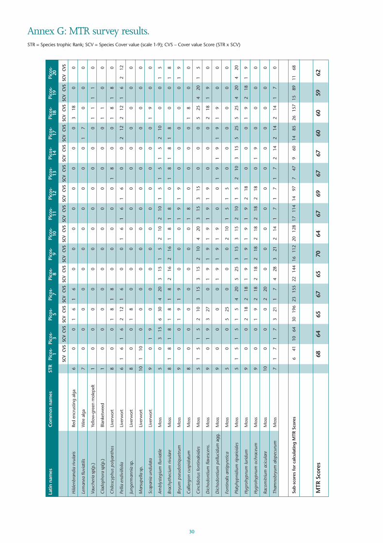
30
Annex G: MTR survey results. STR = Species trophic Rank; SCV = Species Cover value (scale 1-9); CVS – Cover value Score (STR x SCV)
Lati
n na
mes
Com
mon
nam
esST
RPi
cos-
Pi
cos-
Pi
cos-
Pi
cos-
Pi
cos-
Pi
cos-
Pi
cos-
Pi
cos-
Pi
cos-
Pi
cos-
Pi
cos-
Pi
cos-
Pi
cos-
Pi
cos-
Pi
cos-
1
3 5
78
910
1112
1314
1718
1920
SCV
CVS
SCV
CVS
SCV
CVS
SCV
CVS
SCV
CVS
SCV
CVS
SCV
CVS
SCV
CVS
SCV
CVS
SCV
CVS
SCV
CVS
SCV
CVS
SCV
CVS
SCV
CVS
SCV
CVS
Hild
enbr
andi
a riv
ular
isRe
d en
crus
ting
alga
60
01
61
60
00
00
00
03
180
0
Lem
anea
fluv
iatil
isW
ire a
lga
70
00
00
00
00
00
17
00
0
Vauc
heria
sp(p
.)Ye
llow
-gre
en m
olep
elt
10
00
00
00
00
00
01
11
10
Cla
doph
ora
sp(p
.)Bl
anke
twee
d1
00
00
00
00
00
00
11
00
Chi
losc
yphu
s po
lyan
thos
Live
rwor
t8
00
18
18
00
00
01
80
01
81
80
Pelli
a en
divi
ifolia
Live
rwor
t6
16
16
212
16
00
16
16
16
00
212
212
16
212
Jung
erm
anni
asp
.Li
verw
ort
80
01
80
00
00
00
00
00
0
Mar
supe
llasp
.Li
verw
ort
101
100
00
00
00
00
00
00
0
Scap
ania
und
ulat
aLi
verw
ort
90
19
00
00
00
00
00
19
00
Ambl
yste
gium
fluv
iatil
eM
oss
50
315
630
420
315
15
210
210
15
15
15
210
00
15
Brac
hyth
eciu
m r
ivul
are
Mos
s8
18
18
18
18
216
216
18
18
01
81
81
80
01
8
Bryu
m p
seud
otriq
uetr
umM
oss
90
01
91
90
00
19
19
00
00
01
9
Cal
lierg
on c
uspi
datu
mM
oss
80
00
00
00
18
00
00
18
00
Cin
clid
otus
font
inal
oide
sM
oss
51
51
52
103
153
152
104
203
153
150
00
525
420
15
Dic
hodo
ntiu
m fl
aves
cens
.M
oss
90
19
327
01
91
91
91
91
90
00
218
19
0
Dic
hodo
ntiu
m p
ellu
cidu
mag
g.M
oss
90
00
01
91
91
90
01
91
91
91
90
0
Font
inal
is an
tipyr
etic
aM
oss
50
05
250
00
210
15
15
00
00
00
Plat
yhyp
nidi
um r
ipar
ioid
esM
oss
51
51
51
54
205
253
153
152
101
52
103
155
255
254
204
20
Hyg
rohy
pnum
lurid
umM
oss
90
02
182
181
91
91
91
92
180
00
19
218
19
Hyg
rohy
pnum
och
race
umM
oss
90
01
92
182
182
182
182
182
180
19
00
00
Raco
mitr
ium
aci
cula
reM
oss
100
00
220
00
00
00
00
00
0
Tham
nobr
yum
alo
pecu
rum
Mos
s7
17
17
321
17
428
321
214
17
17
17
214
214
214
17
0
Sub-
scor
es f
or c
alcu
lati
ng M
TR S
core
s6
4110
6430
196
2315
522
144
1611
220
128
1711
414
977
479
6014
8526
157
1589
1168
MTR
Sco
res
6864
6567
6570
6467
6967
6760
6059
62

31
Ann
ex H
: JN
CC
mac
roph
yte
surv
ey r
esul
ts. F
igur
es (
1-3)
are
rel
ativ
e an
d ab
solu
te e
stim
ates
of
cove
r w
ithin
the
rive
r ch
anne
l (fir
st tw
o
figur
es)
and
the
wat
er e
dge/
mar
gin
(sec
ond
two
figur
es).
For
mor
e de
tails
, see
JN
CC
ref
eren
ce2 .
Whe
re o
nly
two
figur
es, t
axon
onl
y pr
esen
t at m
argi
n.
Lati
n na
mes
Com
mon
nam
esPi
cos-
1Pi
cos-
3Pi
cos-
4Pi
cos-
5Pi
cos-
6Pi
cos-
7Pi
cos-
8Pi
cos-
9Pi
cos-
10Pi
cos-
11Pi
cos-
12Pi
cos-
13Pi
cos-
14Pi
cos-
15Pi
cos-
17Pi
cos-
18Pi
cos-
19Pi
cos-
20
Hild
enbr
andi
a riv
ular
isRe
d en
crus
ting
alga
1100
1100
1100
3300
Le
man
ea fl
uvia
tilis
Wire
alg
a11
00
Blue
-gre
en a
lgal
scu
m11
0011
0032
2111
1111
1111
1111
1111
1111
2222
2221
21Va
uche
riasp
(p.)
Yello
w-g
reen
mol
epel
t11
1111
00C
lado
phor
a/Rh
izoc
loni
umBl
anke
twee
d11
00
Fila
men
tous
gre
en a
lgae
1100
1100
2200
1100
1100
1100
2200
Encr
ustin
g lic
hens
1111
1111
1111
1111
1111
1111
1111
1111
Folio
se li
chen
s11
1111
1111
1111
1111
Chi
losc
yphu
s po
lyan
thos
Live
rwor
t11
1111
1111
1111
1111
1111
1111
1122
1111
1111
11C
onoc
epha
lum
con
icum
Live
rwor
t21
1111
1111
1111
1111
1122
1111
11Ju
nger
man
nia
sp.
Live
rwor
t11
1111
11Lu
nula
ria c
ruci
ata
Live
rwor
t11
1111
1111
Mar
chan
tia p
olym
orph
aLi
verw
ort
1111
1111
1111
1111
1111
Mar
supe
llasp
.Li
verw
ort
1111
Pe
llia
endi
viifo
liaLi
verw
ort
1121
1111
1111
1111
1111
1111
1111
1111
1111
1122
1111
1121
2233
1122
2121
Ricc
ardi
a ch
amed
ryfo
liaLi
verw
ort
2222
Scap
ania
sp.
Live
rwor
t11
1111
1111
11Am
blys
tegi
um fl
uvia
tile
Mos
s32
3232
2232
2233
3333
2232
2222
2211
1132
2232
2232
2211
1111
1111
1111
2122
1111
1111
00Br
achy
thec
ium
riv
ular
eM
oss
2132
2132
2211
2211
2211
2233
1132
1111
1111
2111
2111
3211
3211
2211
2221
Bryu
m p
seud
otriq
uetr
umM
oss
1111
1111
1111
Cal
lierg
onel
la c
uspi
datu
mM
oss
1111
1111
1111
11C
incl
idot
us fo
ntin
aloi
des
Mos
s21
2111
1122
3222
2222
2232
2222
2222
3222
3222
3222
3233
3322
3311
11C
rato
neur
on fi
licin
umM
oss
1111
1111
1121
1111
1111
1111
1121
2111
1111
22D
icho
dont
ium
pel
luci
dum
agg.
Mos
s11
2121
3322
1122
1122
1122
1122
1122
1122
1122
1122
1121
1121
1121
1111
1122
1122
Font
inal
is an
tipyr
etic
aM
oss
2211
1122
1111
1111
11H
ygro
hypn
um lu
ridum
Mos
s11
1111
1122
1111
1111
2211
2222
2222
2222
3211
1111
1111
11H
ygro
hypn
um o
chra
ceum
Mos
s11
1111
1111
2222
1111
1111
1111
1111
11O
rtho
tric
hum
sp.
Mos
s11
1111
Philo
notis
font
ana
Mos
s11
11Pl
atyh
ypni
dium
rip
ario
ides
Mos
s11
1111
11
1111
1111
1111
1111
3311
3222
2222
2222
1111
3221
3232
3232
3333
3322
3232
3232
Raco
mitr
ium
aci
cula
reM
oss
1121
2111
2111
21Sc
hist
idiu
m r
ivul
are
Mos
s11
2122
1111
1111
1111
1111
2121
1111
1111
2211
Tham
nobr
yum
alo
pecu
rum
Mos
s11
3221
2211
3311
3311
3311
3322
3311
3211
2211
2211
2211
3211
3221
3211
3222
2211
2221
Osm
unda
reg
alis
Roya
l Fer
n11
2111
00O
ther
fern
s21
2111
2222
1111
1111
1111
1121
1111
11An
gelic
a sy
lves
tris
Wild
Ang
elic
a11
1111
1111
11Ap
ium
nod
iflor
umFo
ol's
Wat
er-c
ress
2211
1111
Cal
litric
he s
tagn
alis
Com
mon
Sta
rwor
t11
00C
alth
a pa
lust
risM
arsh
Mar
igol
d11
Eupa
toriu
m c
anni
binu
mH
emp
Agrim
ony
1111
1111
Lotu
s pe
dunc
ulat
usM
arsh
Tre
foil
1111
11M
enth
a aq
uatic
aag
g.W
ater
Min
t11
1111
1111
1111
1111
1111
1111
1111
1111
1122
1111
Myo
sotis
sco
rpio
ides
Wat
er F
or-g
et-m
e-no
t11
11Po
tent
illa
erec
taC
omm
on T
orm
entil
1111
1111
Sagi
na p
rocu
mbe
nsPe
arl-w
ort
3211
1111
1111
Scro
phul
aria
aur
icul
ata
Wat
er F
igw
ort
1111
1111
1111
1111
11

32
Ann
ex H
: con
tinue
dLa
tin
nam
esC
omm
on n
ames
Pico
s-1
Pico
s-3
Pico
s-4
Pico
s-5
Pico
s- 6
Pico
s-7
Pico
s-8
Pico
s-9
Pico
s-10
Pico
s-11
Pico
s-12
Pico
s-13
Pico
s-14
Pico
s-15
Pico
s-17
Pico
s-18
Pico
s-19
Pico
s- 2
0
Sene
cio
aqua
tica
Mar
sh R
agw
ort
11Tu
ssila
go fa
rfar
aC
olt's
-foot
1111
11Al
nus
sp(p
.)Al
der
1121
1111
1111
1111
11Sa
lixsp
p.W
illow
1121
1111
1111
1122
1111
11O
ther
tre
es11
1111
2111
1111
1111
1111
1121
1121
1132
1122
11ot
her
dico
tyle
dons
2121
1122
2211
1111
1111
1121
2111
2111
2211
Car
ex n
igra
Com
mon
Sed
ge11
11C
arex
pen
dula
Pend
ulou
s Se
dge
11C
arex
rem
ota
Rem
ote
Sedg
e11
1111
Car
ex v
iridu
laYe
llow
-sed
ge11
11G
lyce
ria n
otat
a/flu
itans
Swee
t-gr
ass
1111
Junc
us e
ffusu
sSo
ft Ru
sh11
1111
11Ju
ncus
infle
xus
Har
d Ru
sh11
1111
1111
Phal
aris
arun
dina
cea
Reed
Can
ary-
gras
s11
Oth
er m
onoc
otyl
edon
s21
2111
1111
1111
1111
1111
2111
2111
2121
1122
1111
Non
Che
ck-li
st s
pec
ies
Nos
toc
sp(p
.)Bl
ue g
reen
alg
a21
0011
0011
0011
0011
0011
1111
1111
00H
ydru
rus
foet
idus
Chr
ysop
hyte
alg
a33
00C
olle
ma
sp(p
.)Fo
liose
lich
en11
1111
1111
1111
1111
Plag
ioch
ila a
sple
nioi
des
Live
rwor
t11
Nec
kera
com
plan
ata
Live
rwor
t11
1111
Ambl
yste
gium
ten
axM
oss
1111
1111
1111
1121
2211
1111
1111
Bryu
m d
icho
tom
umM
oss
1111
11C
incl
idot
us r
ipar
ius
Mos
s32
2222
2222
2222
1122
2222
232
2132
1132
2133
1132
11D
idym
odon
spa
dice
usM
oss
1111
11Eu
clad
ium
ver
ticill
atum
Mos
s11
Fiss
iden
s po
lyph
yllo
usM
oss
2211
3311
2211
1111
2200
1100
3200
1100
2200
Grim
mia
har
tman
iiM
oss
11M
nium
hor
num
Mos
s32
1111
1111
1111
1111
11Pa
lust
riella
com
mut
atum
Mos
s11
1122
1111
1111
1111
1122
1111
Plag
iom
nium
ros
trat
umM
oss
2121
1111
1111
1111
1111
1111
1121
2211
11Pl
agio
mni
um u
ndul
atum
Mos
s21
1111
1111
1111
1111
11Rh
izom
nium
pun
ctat
umM
oss
2111
1111
1111
11Sc
lero
podi
um c
espi
tans
Mos
s11
11O
ther
woo
dlan
d m
osse
s21
3211
2211
1111
2121
21Eq
uise
tum
arv
ense
Cre
epin
g H
orse
-tai
l11
2111
1111
1111
1111
1111
1111
1111
1111
1111
Euon
ymus
eur
opae
usSp
indl
e11
Car
dam
ine
raph
anifo
liaIb
eria
n Bi
tter
-cre
ss11
1111
1111
2111
1111
1111
1111
1111
1111
21C
arex
str
igos
aW
ood
Sedg
e11
Chr
ysos
plen
ium
opp
ositi
foliu
mO
ppos
ite-le
aved
G
olde
n-sa
xifr
age
1111
1111
1111
1111
1111
11Lu
zula
syl
vatic
aG
reat
Woo
d-ru
sh21
1121
1121
Myo
sotis
pal
ustr
isM
arsh
For
-get
-me-
not
2111
2111
21Pr
unel
la v
ulga
risSe
lfhea
l11
Saxi
frag
a gr
anul
ata
Mea
dow
Sax
ifrag
e11
1111
11Va
leria
nasp
.Va
leria
n11
1111
1111
1111
11
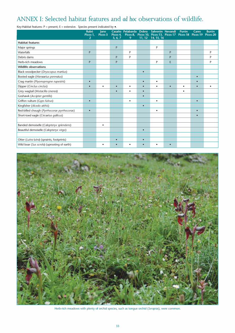
33
ANNEX I: Selected habitat features and ad hoc observations of wildlife.Key:Habitat features: P = present; E = extensive. Species present indicated by ●.
Rubó Jano Casaño Pelabarda Dobra Salvorón Nevandi Purón Cares BurónPicos-1, Picos-3 Picos-4, Picos-8, Picos-10, Picos-13, Picos-17 Picos-18 Picos-19 Picos-20
2 5, 6, 7 9 11, 12 14, 15, 16
Habitat features
Major springs P P
Waterfalls P P P P
Debris dams P P P P
Herb-rich meadows P P P E P
Wildlife observations
Black woodpecker (Dryocopus martius) •
Booted eagle (Hieraaetus pennatus) •
Crag martin (Ptyonoprogne rupestris) • • • •
Dipper (Cinclus cinclus) • • • • • • • • • •
Grey wagtail (Motacilla cinerea) • • • •
Goshawk (Accipter gentilis) •
Griffon vulture (Gyps fulvus) • • • •
Kingfisher (Alcedo atthis) •
Red-billed chough (Pyrrhocorax pyrrhocorax) • • •
Short-toed eagle (Circaetus gallicus) •
Banded demoiselle (Calopteryx splendens) •
Beautiful demoiselle (Calopteryx virgo) •
Otter (Lutra lutra) (spraints, footprints) • •
Wild boar (Sus scrofa) (uprooting of earth) • • • • • •
Herb-rich meadows with plenty of orchid species, such as tongue orchid (Serapias), were common.

ACKNOWLEDGEMENTSThanks to: Picos de Europa National Park, for permission to work in the National Park and
Fransisco de Borja Palacios Alberti for advice on access; Fernando Magdaleno (CEDEX; Ministerio deFomento; Ministerio de Medio Ambiente y Medio Rural y Marino) for advice, geology maps andessential translation services; John Mead, Teresa Farino and Jim Thomson for advice on the localweather, flora and fauna; Paul Holmes for putting the macrophyte data onto the JNCC database;
Hugh Dawson for the water chemistry analysis; Ben Averis for verifying several bryophyte specimens;Brian Whitton for identifying the alga Hydrurus foetidus; Professor Tony Brown (SouthamptonUniversity) for information on geology and geomorphology; Eleanor Raven for producing the
location maps; and Emma Churchill for typing the report in its many drafts.
APPROXIMATE LOCATIONS OF SITES SURVEYED
Sour
ce: L
os P
icos
de
Euro
pe y
Cos
ta O
rien
tal d
e A
stor
ias;
Mig
uel A
. Adr
ados