rise up izu peninsula geopark - 伊豆半島ジオパーク · 2017. 12. 12. · rise up izu...

1
監修:伊豆半島ジオパーク推進協議会 http://izugeopark.org/ 源兵衛川:湧水と暮らしてきた人の暮らしと水辺の生き物 Genbeigawa River : The clear stream linked with the local life Kitaizu AreaMishima Geosite / Genbē River 北伊豆エリア:三島ジオサイト /源兵衛川 設置・管理者:三島市 商工観光課 http://www.city.mishima.shizuoka.jp/ 伊豆半島ジオパーク IZU PENINSULA GEOPARK ここは 「三島市」 Here is Mishima City 三島駅 Mishima Sta. Kisegawa River Kanogawa River Kakitagawa River Daibagawa River Sakaigawa River 1 246 246 136 三島溶岩の分布 Distribution of Mishima Lavas 地下水のながれ Flow of Groundwater 富士山 Fuji Volcano 愛鷹山 Ashitakayama Volcano 箱根 Hakone Volcanoes 丹沢山地 Tanzawa Mountains 伊豆と本州の衝突によって隆起した山々 Mountains uplifted by the collision of Izu and Honshu Momozawagawa River 白滝公園 Shirataki park 菰池 Komoike pond 鮎止めの滝 Ayudome fall 鮎壺の滝 Ayutsubo falls 清住緑地・丸池 Kiyozumi green area Maruike pond 楽寿園・小浜池 Rakujuen Kohamaike pond 水の苑緑地 Mizunosono green area 柿田川公園 Kakitagawa park 本城山 Mt. Honjoyama 香貫山 Mt. Kanukiyama 駿河平 Surugadaira 窪の湧水 Kubo water spring 三嶋大社 Mishimataisha shrine 新東名高速道路 東名高速道路 Tomei Expressway 東駿河湾環状道路 Hi g as hi -Sur ug a wa n K a n j o R oa d 箱根西麓地域 Hakone west foot area 箱根西麓三島野菜のふるさと Production areas of The Hakone Mishima west foot vegetables 竹倉温泉 Takekura spa 伊豆箱根鉄道 I z u h a k o n e Ra i l wa y 御殿場線 東海道本線 Tokaido Main Line 東海道新幹線 Tokaido Shinkansen 主な湧水地 Water springs 伊豆が海底火山だったころのなごり Trace of when Izu was submarine volcanoes Mt. Fuji was born near the junction of Izu and Honshu around 100,000 years ago. A large eruption of Mt. Fuji drove lava through the valley surrounded by Mt. Ashitaka and Hakoneand reached as far as Mishima. This is known as the Mishima Lava Flow and it created the land we see in the northern part of Mishima City. This lava is full of fissures and cracks, so groundwater seeps through it easily. This water in turn gushes out in the form of natural springs at the end of the lava flow This groundwater nourishes many clear streams. In waterscapes like the Genbei River and the Sakura River are examples of how local societies cohabited with these beautiful natural streams. Visitors here can enjoy many unique local products aside from the landscapes created by lava flow and flowing water. およそ10万年前、伊豆と本州の境界付近に富士山が誕生しました。約1万前の噴火では、愛鷹 山と箱根に挟まれた谷を溶岩が流れ下り、三島付近にまで到達しました。「三島溶岩」と呼ばれ るこの溶岩は、三島市北部の大地を作りだしました。また、亀裂やすき間の多い溶岩は、地下水 の通り道となって、溶岩の末端付近にたくさんの湧水をもたらしています。 湧水は多くのせせらぎを作りだしました。源兵衛川や桜川などの用水も、湧水とともに暮らし てきた人々の知恵で、たくさんの工夫がつまっています。街中で見られる三島溶岩やたくさんの 湧水だけでなく、水辺の生き物や湧水を使った特産品などもぜひ楽しんでください。 この地図の作成に当たっては、国土地理院長の承認を得て、同院発 行の基盤地図情報を使用した。(承認番号 平25情使、 第591号) 鳥瞰図の描画には「カシミール3D」を使用した。 きょうかい とうたつ はさ あしたか まったん きれつ さくらがわ ち え 源兵衛川 Genbaigawa River 中郷温水池 Nakazato-Onsuichi ( water heating reservoir ) 冷たい湧水を水田に適した温度ま で温めてから分配します。 Cold springwater is distributed after heating to a temperature suitable for a paddy field. Shin-Tomei Expressway Gotemba Line Philippine Sea Plate Pacific Plate Eurasian Plate ユーラシアプレート North American Plate 4cm/year 8cm/year Magma rise up Izu Peninsula フィリピン海プレート 太平洋 プレート 北アメリカ プレート マグマの発生 伊豆半島 本州で唯一、フィリピン海プレート上に位置する伊 豆半島は、かつては南洋にあった火山島や海底火 山の集まりでした。この海底火山群は、プレートと ともに ほくじょう 北上 し、本州に しょうとつ 衝突 して半島になりました。 約60万年前の出来事です。伊豆半島では、現在も火 山活動や ちかくへんどう 地殻変動 が続いており、これによって豊か な温泉や湧水などの恵み、変化に富んだ地形をも つ魅力的な半島が形作られています。  Izu Peninsula is the only part located on the Philippine Sea Plate in Honshu. This part was originally a group of volcanic islands and submarine volcanoes in the South Seas. These islands and volcanoes drifted by the north- ward motion of the Philippine Sea Plate and collided with Honshu island (the main island of Japan) about 600,000 years ago to form a peninsula. Even now, volca- nic activity and crustal movements continue in this pen- insula. As a result, various “Gifts” of nature such as abun- dant hot springs, spring water and natural scenery are enjoyed by the people of the peninsula. から来た 火山 の贈りもの Volcano Gifts from the South 200~100万年前 21 million years ago 本州への衝突のはじまり 80~40km 陸地 本州 熱海層群最下部の 砂や泥が堆積 Honshu 2000~1000万年前 20 10 million years ago プレート 沈み込み口 海底火山 深い海での火山活動 Deep Submarine Volcanism 本州 800 ~ 400km Honshu Trench Submarine Volcanoes 1000~200万年前 10 2 million years ago 浅い海での火山活動 Shallow Submarine Volcanism 海底火山 プレート 沈み込み口 400 ~ 80km 小火山島 本州 Honshu Trench Submarine Volcanoes Small Volcanic Island 100~60万年前 1 0.6 million years ago 衝突の進行 Progress of the collision 丹沢山地の隆起と浸食 伊豆半島の隆起 Uplit and Erosion of Tanzawa mountains Uplift of Izu Massif 60万年前 0.6 million years ago 蛇石火山 宇佐美火山 達磨火山 多賀火山 Taga Volcano Usami Volcano Jyaishi Volcano Daruma Volcano 60~20万年前 0.6 0.2 million years ago ほぼ現在の伊豆半島に The Peninsula gets its present shape 伊豆半島の原型の完成 箱根火山 Amagi Volcano Hakone Volcano 天城火山 生きている伊豆半島 伊豆東部火山群 石廊崎断層 Irozaki Fault Izu Tobu Volcano Group 駿河湾 Suruga Bay Geological Hi story of Izu Peninsula Izu block An active monogenetic volcano field and crustal movements Submarine Volcanoes Terrestrial Volcanoes Collision to Main Island (Honshu) Birth of Izu Peninsula Start of collision 丹那断層 Tanna Fault 富士山 FujiVolcano 愛鷹山 Ashitakayama Volcano 0.2 million years ago Recent 20万年前~現代 源兵衛川の歴史と水辺の生き物 History of Genbeigawa River and riparian life Genbeigawa River originates from the the springwater of the Kohamaike Pond. Beautiful warerscapes are visible on the sides of the river. The river is actually an irrigation canal, it flows through the Mishima City Area and reaches the Nakasato-Onsuichi (water heating reservoir) about 1.5 kilometers downstream. The cold springwater of the Genbeigawa River is warmed to the temperature suitable for rice farming, and then channeled into the nearby fields. You can enjoy pleasant water landscapes at several places along the stretch of the river, from Kohama Ike Pond to the hot springs. ゲンジボタル Genji firefly ホトケドジョウ Japanese eight-barbel loach ミシマバイカモ Mishima baikamo Kingfisher カワセミ 源兵衛川は楽寿園の小浜池の湧水を源流とする河川 で、この川沿いには美しい水辺空間がつくられています。 灌漑用水路として作られたこの川は三島市街地を流れ 下り、「水の苑緑地」を抜けて約1.5km下流の「中郷温水池」 に流れ込んでいます。源兵衛川を流れる冷たい湧水は、温 水池で農業に適した温度まであたためられてから周囲の 田んぼに分配されています。小浜池から温水池まで、各所 に水辺を楽しむ工夫がありますので、ぜひ散策を楽しんで ください。 In the past the Genbei River had a close relationship with the people of the Mishima City. However, the water table of this area changed drastically during the 1960s, as groundwater was extracted during the economic growth years. The water level dropped off, and the river became polluted with domestic sewage. Eventually, local inhabitants came together to restore the river, and today what you see as Genbeigawa River is the result of these restoration initiatives. 市街地を流れる源兵衛川は、人々の生活に密着した川で した。しかし1960年代中頃、周辺地域の経済成長にともな う地下水の汲み上げなどより、湧水の量が減少、水が少な くなった河川に生活排水などが流れ込み、水辺環境が悪化 してしまいました。現在の美しい三島の水辺は、多くの市民 による地道な保全・回復活動によってよみがえり、守られて いるのです。 こうした水辺には、三島市の鳥「カワセミ」をはじめとし て、ミシマバイカモやゲンジボタルなどたくさんの生物が 育まれ、すぐれた生物観察の場にもなっています。 かんがいようすいろ らくじゅえん みず そ の りょくち なかざとおんすいち ぶんぱい さんさく みっちゃく けいざいせいちょう げ んしょう はいすい ほぜん かいふく area 0m 500m 500m 1000m 1000m 0m 500m 500m 1000m 1000m 1500m 現在地 You are here 1500m 1500m Koshikiri-Fudouson Temple 三嶋大社 Mishima Taisha Shrine 大社の杜 Taisha no Mori Shopping Center 佐野美術館 Sano Art Museum 小浜池 Kohamaike Pond 楽寿園 Rakujuen Park 菰池公園 Komoike Park 鏡池 Kagamiike Pond 白滝公園 Shirataki Park JR東海三島駅 Central Japan Railway Mishima Station 三島広小路駅 Mishima-Hirokoji Station 浅間神社 Sengenjinja Shrine 源兵衛川 Genbeigawa River 蓮沼川(宮さんの川) Hasunumagawa River 四ノ宮川 Shinomiyagawa River 四ノ宮川水源池 Shinomiyagawa Well 雷井戸 Kaminari Well 水の苑緑地 Mizunosono-Ryokuchi Park 三島梅花藻の里 Mishimabaikamo no Sato 三島市役所 Mishima City Hall 三島市民文化会館 (ゆうゆうホール) Mishima Citizens Cultural Hall 大場川(神川) Daibagawa River Sakuragawa River 御殿川 Gotengawa River 三島市郷土資料館 Mishima City Falk Museum 三嶋暦師の館 Mishima-Goyomi Calender Museum 三石神社 Mitsuishijinja Shrine 大岡信ことば館 Ooka Makoto Kotoba Museum 三島田町駅 Mishima-Tamachi Station 伊豆国分寺跡 Remains of the Izukokubunji Temple 腰切不動尊 祐泉寺 Yusenji Temple 愛染院跡の溶岩塚 Lava Tumulus of Aizeninato 順天堂大学保健看護学部 Juntendo University School of Health Sciences and Nursing 三島商工会議所 The Mishima Chamber of Commerce and Industry 楽寿館 Rakuju-kan Imperial Villa さんしんギャラリー善 Sanshin Zen Gallery 言成地蔵 Iinarijizo Temple 間眠神社 Madoromjinja Shrine 細小路 Hosokoji Alley 歴門のみち Komikado no Michi Alley 上の小路 Uenokoji Alley 下の小路 Shitanokoji Alley 阿闍梨小路 Ajarikoji Alley 桜小路 Sakurakoji Alley 問屋小路 Toiyakoji Alley 金谷小路 Kanayakoji Alley 三島市民生涯学習センター 三島市立図書館 Citizen of Mishima Lifelong Learning Center Mishima City Library via701 樋口本陣跡 芭蕉の碑 世古本陣跡 伊豆半島ジオパーク 三島ビジターセンター Izu Peninsula Geopark Mishima Vister Center 総合観光案内所 Tourist Information 小浜のみち Kohama no Michi Alley 搗屋のみち Tsukiya no Michi Alley 圓明寺 Enmyoji Temple 隆泉苑 Ryusenen Japanese Garden 祓所神社 Haraidojinja Shrine 御幸通り Miyukidori Street 愛染坂 Aizensaka Slope 水辺の文学碑 Epigraph on Monument in the Waterside 舞殿 Maidono Stage 三嶋大社宝物館 Treasure Museum Monument of Basho Higuchi-Honjin (Historical Residence) Seko-Honjin (Historical Residence) 源兵衛川 Genbeigawa River 御殿川 Gotengawa River ボイスキュー(FMみしまかんなみ) VOICE CUE FM Mishima Kannami 三島メディカルセンター Mishima Medical Center 伊豆箱根鉄道三島駅 Izuhakone Railway Mishima Station 小浜用水(千貫樋用水) Obama Water for Irrigation JR東海道新幹線 Central Japan Railway Shinkansen(bullet train) Line JR東海道本線 Central Japan Railway Tokaido Line 三島宿問屋場跡 Mishima Post Town Logistics Center 三島駅北口 Mishima Station North 日本大学国際関係学部北口校舎 Nihon University College of International Relations 駿 Iz u h a k o n e Railway Sun z u Line 本覚寺 Hongakuji Temple ほたるの里 Hotaru no Sato 蓮馨寺 Renkeiji Temple 時の鐘 Tokinokane Bell 木町観音堂 Kimachi-Kannon Temple 至清水町 To Shimizu Town 至中郷温水池 To Nakazato-Onsuichi 至伊豆の国市 To Izunokuni City Tokaido(Edo-period Edo-Kyoto highway) Shimoda-Kaido Road 至箱根 To Hakone 甲州道(佐野街道) Koushudo Road 10m 20m 30m 40m 50m 60m 標 高 Elevation 凡 例 Legend ジオポイント Geopoint 公園 Park 鉄道駅 Railway Station 歴史的建造物 Historical Monument 地形データ提供 : 国土交通省中部地方整備局沼津河川国道事務所 博物館 / 美術館 Museum 湧水 Spring Water トイレ Toilet 休憩所 / 待合室 Lounge/Waiting Room 案内所 Question & Answer モデルコース おすすめコース Recommended よくばりコース All You Can Walk Model Courses 0cm 50cm 100cm 150cm 200cm 250cm -250cm -200cm -150cm -100cm -50cm 0cm 50cm 100cm 150cm 200cm 250cm 0mm 50mm 100mm 150mm 200mm 250mm 富士山頂の雪の深さ Snow depth in Fuji summit Dayly rainfall at Gotenba city Water level of Kohamaike pond 小浜池の水位 御殿場で 1 日に降った雨の量 1月 8月 9月 10 月 11 月 12 月 2月 3月 4月 5月 6月 7月 1月 8月 9月 10 月 11 月 12 月 2月 3月 4月 5月 6月 7月 標高 25.69m Elevation (計測:三島市立公園楽寿園) 小浜池の水位は、標高 25.69m を基準として測られています。 The water level of Kohamaike pond is measured relative to the elevation 25.69m. 雪解けによる水位上昇 The water level rise caused by snow melt 大雨による水位上昇 The water level rise caused by heavy rain 富士山の雪解け Snow melt of Mt. Fuji 2003年 夏と冬の源兵衛川は、水の量がまったく違います。これは、源 兵衛川の水源である楽寿園の小浜池に湧き出す水の量が季節 によって変化するからです。 2003年を例に見てみましょう。上のグラフを見ると、4月ごろ から富士山で雪解けが始まるとともに、小浜池の水位が上がり はじめています。これは、富士山の中にしみこんだ雪解け水が 地下水を押し、小浜池の湧水が増えるためと考えられています。 もちろん富士山の雪解けだけでなく、富士山の近くに降った 雨でも同じようなことがおこります。例えば8月半ばに降った御 殿場の大雨の時にも小浜池の水位が上がっている様子がわか ります。やがて雨や雪解けの少ない冬になると、湧水の量は再 び減っていきます。 Water level in the Genbeigawa River is starkly different in summer and winter. This is due to the change in the water level of the Koham- aike Pond in the Rakujuen Park, which is the source of this river. Let us see the example of 2003. From the graph above it is clear that when the snow of Mt. Fuji starts melting around April, the water level of Kohamaike Pond goes up. This is due to the snowmelt having a direct influence on the increase of groundwater of this area. Of course, the effect is not solely due to the snowmelt from Mt. Fuji. Rain that falls around Mt. Fuji also creates a similar effect. For ex- ample, heavy rains in Gotenba in August are seen as linked to the rise of water level in Kohamaike pond. The water level drops off in the winter, when meltwater is no longer supplied from the mountain. 冬のようす 夏のようす Winter Summer 小浜池 Kohamaike Pond Genpeigawa River Kohamaike Pond Genpeigawa River 源兵衛川 小浜池 源兵衛川 三島の湧水と富士山の雪解けのカンケイ Relationship of Snow melt of Mt. Fuji and Spring water of Mishima なか てんば こはまいけ

Upload: others

Post on 14-Oct-2020

1 views

Category:

Documents


0 download

TRANSCRIPT

大型解説版 200cm × 130cm

監修:伊豆半島ジオパーク推進協議会  http://izugeopark.org/

源兵衛川:湧水と暮らしてきた人の暮らしと水辺の生き物Genbeigawa River : The clear stream linked with the local life Kitaizu Area:Mishima Geosite / Genbē River

北伊豆エリア:三島ジオサイト /源兵衛川

設置・管理者:三島市 商工観光課 http://www.city.mishima.shizuoka.jp/

げ ん べ い が わげ ん べ い が わ

伊豆

半島

ジオ

パー

クIZ

U P

ENIN

SU

LA G

EOP

AR

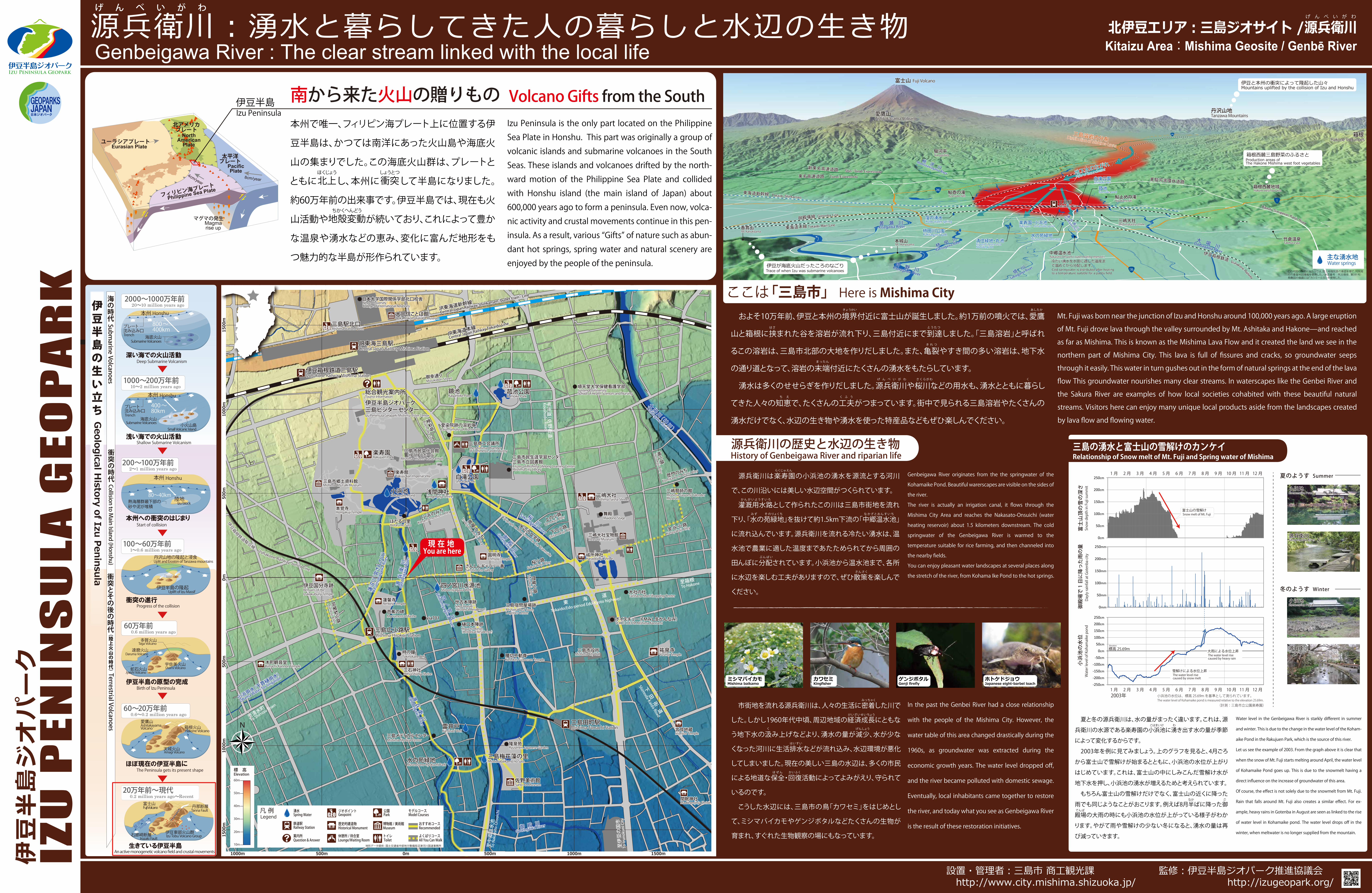
K ここは「三島市」 Here is Mishima City

三島駅Mishima Sta.

黄 瀬 川Kisegawa River

狩 野 川Kanogawa River

柿 田 川

Kakitagaw

a River 大 場 川Daibagawa River

境川

Sakaigawa River

1

246

246

136

三島溶岩の分布Distribution of Mishima Lavas

地下水のなが

Flow of Groun

dwater

富士山 Fuji Volcano

愛鷹山Ashitakayama Volcano

箱根Hakone Volcanoes

丹沢山地Tanzawa Mountains

伊豆と本州の衝突によって隆起した山々Mountains uplifted by the collision of Izu and Honshu

桃沢川

Momozawagawa River

白滝公園Shirataki park

菰池Komoike pond

鮎止めの滝Ayudome fall

鮎壺の滝Ayutsubo falls

清住緑地・丸池Kiyozumi green areaMaruike pond

楽寿園・小浜池Rakujuen ・ Kohamaike pond

水の苑緑地Mizunosono green area

柿田川公園Kakitagawa park

本城山Mt. Honjoyama

香貫山Mt. Kanukiyama

駿河平Surugadaira

窪の湧水Kubo water spring 三嶋大社

Mishimataisha shrine

新東名高速道路

東名高速道路 Tomei Expressway東駿河湾環状道路

Higashi-Surugawan Kanjo Road

箱根西麓地域Hakone west foot area

箱根西麓三島野菜のふるさとProduction areas ofThe Hakone Mishima west foot vegetables

竹倉温泉Takekura spa

伊豆箱根鉄道Izuhakone Railway

御殿場線

東海道本線 Tokaido Main Line

東海道新幹線 Tokaido Shinkansen

主な湧水地Water springs伊豆が海底火山だったころのなごり

Trace of when Izu was submarine volcanoes

Mt. Fuji was born near the junction of Izu and Honshu around 100,000 years ago. A large eruption

of Mt. Fuji drove lava through the valley surrounded by Mt. Ashitaka and Hakone̶and reached

as far as Mishima. This is known as the Mishima Lava Flow and it created the land we see in the

northern part of Mishima City. This lava is full of fissures and cracks, so groundwater seeps

through it easily. This water in turn gushes out in the form of natural springs at the end of the lava

flow This groundwater nourishes many clear streams. In waterscapes like the Genbei River and

the Sakura River are examples of how local societies cohabited with these beautiful natural

streams. Visitors here can enjoy many unique local products aside from the landscapes created

by lava flow and flowing water.

 およそ10万年前、伊豆と本州の境界付近に富士山が誕生しました。約1万前の噴火では、愛鷹

山と箱根に挟まれた谷を溶岩が流れ下り、三島付近にまで到達しました。「三島溶岩」と呼ばれ

るこの溶岩は、三島市北部の大地を作りだしました。また、亀裂やすき間の多い溶岩は、地下水

の通り道となって、溶岩の末端付近にたくさんの湧水をもたらしています。

 湧水は多くのせせらぎを作りだしました。源兵衛川や桜川などの用水も、湧水とともに暮らし

てきた人々の知恵で、たくさんの工夫がつまっています。街中で見られる三島溶岩やたくさんの

湧水だけでなく、水辺の生き物や湧水を使った特産品などもぜひ楽しんでください。

この地図の作成に当たっては、国土地理院長の承認を得て、同院発行の基盤地図情報を使用した。(承認番号 平25情使、 第591号)鳥瞰図の描画には「カシミール3D」を使用した。

きょうかい

とうたつはさ

あしたか

まったん

き れ つ

さくらがわげ ん べ い が わ く

ち え く ふ う

源兵衛川

Genbaigawa River

中郷温水池Nakazato-Onsuichi ( water heating reservoir )冷たい湧水を水田に適した温度まで温めてから分配します。Cold springwater is distributed after heating to a temperature suitable for a paddy field.

Shin-Tomei Expressway

Gotemba Line

Philippine Sea Plate

PacificPlate

Eurasian Plateユーラシアプレート

NorthAmerican

Plate

4cm/year8cm/year

Magmarise up

Izu Peninsula

フィリピン海プレ

ート

太平洋プレート

北アメリカプレート

マグマの発生

伊豆半島

本州で唯一、フィリピン海プレート上に位置する伊

豆半島は、かつては南洋にあった火山島や海底火

山の集まりでした。この海底火山群は、プレートと

ともにほくじょう

北上し、本州にしょうとつ

衝突して半島になりました。

約60万年前の出来事です。伊豆半島では、現在も火

山活動やちかくへんどう

地殻変動が続いており、これによって豊か

な温泉や湧水などの恵み、変化に富んだ地形をも

つ魅力的な半島が形作られています。 

Izu Peninsula is the only part located on the Philippine

Sea Plate in Honshu. This part was originally a group of

volcanic islands and submarine volcanoes in the South

Seas. These islands and volcanoes drifted by the north-

ward motion of the Philippine Sea Plate and collided

with Honshu island (the main island of Japan) about

600,000 years ago to form a peninsula. Even now, volca-

nic activity and crustal movements continue in this pen-

insula. As a result, various “Gifts” of nature such as abun-

dant hot springs, spring water and natural scenery are

enjoyed by the people of the peninsula.

南から来た火山の贈りもの Volcano Gifts from the South

200~100万年前2~1 million years ago

本州への衝突のはじまり

80~40km陸地

本州

熱海層群最下部の砂や泥が堆積

Honshu

2000~1000万年前20~10 million years ago

プレート沈み込み口

海底火山

深い海での火山活動Deep Submarine Volcanism

本州

800~400km

Honshu

TrenchSubmarine Volcanoes

1000~200万年前10~2 million years ago

浅い海での火山活動Shallow Submarine Volcanism

海底火山

プレート沈み込み口

400~80km

小火山島

本州 Honshu

Trench

Submarine VolcanoesSmall Volcanic Island

100~60万年前1~0.6 million years ago

衝突の進行Progress of the collision

丹沢山地の隆起と浸食

伊豆半島の隆起

Uplit and Erosion of Tanzawa mountains

Uplift of Izu Massif

60万年前0.6 million years ago

蛇石火山宇佐美火山

達磨火山

多賀火山Taga Volcano

Usami VolcanoJyaishi Volcano

Daruma Volcano

60~20万年前0.6~0.2 million years ago

ほぼ現在の伊豆半島にThe Peninsula gets its present shape

伊豆半島の原型の完成

箱根火山

Amagi Volcano

Hakone Volcano

天城火山

生きている伊豆半島

伊豆東部火山群石廊崎断層Irozaki Fault Izu Tobu Volcano Group

駿河湾Suruga Bay

Geological H

istory of Izu Peninsula

Izu block

An active monogenetic volcano field and crustal movements

伊豆半島の生い立ち

Submarine Volcanoes

Terrestrial Volcanoes

衝突とその後の時代(陸上火山の時代)

Collision to Main Island (Honshu)

海の時代

衝突の時代

Birth of Izu Peninsula

Start of collision

丹那断層Tanna Fault

富士山Fuji Volcano

愛鷹山AshitakayamaVolcano

0.2 million years ago~Recent20万年前~現代

源兵衛川の歴史と水辺の生き物History of Genbeigawa River and riparian life

Genbeigawa River originates from the the springwater of the

Kohamaike Pond. Beautiful warerscapes are visible on the sides of

the river.

The river is actually an irrigation canal, it flows through the

Mishima City Area and reaches the Nakasato-Onsuichi (water

heating reservoir) about 1.5 kilometers downstream. The cold

springwater of the Genbeigawa River is warmed to the

temperature suitable for rice farming, and then channeled into

the nearby fields.

You can enjoy pleasant water landscapes at several places along

the stretch of the river, from Kohama Ike Pond to the hot springs.

ゲンジボタルGenji firefly

ホトケドジョウJapanese eight-barbel loach

ミシマバイカモMishima baikamo Kingfisher

カワセミ

 源兵衛川は楽寿園の小浜池の湧水を源流とする河川

で、この川沿いには美しい水辺空間がつくられています。

 灌漑用水路として作られたこの川は三島市街地を流れ

下り、「水の苑緑地」を抜けて約1.5km下流の「中郷温水池」

に流れ込んでいます。源兵衛川を流れる冷たい湧水は、温

水池で農業に適した温度まであたためられてから周囲の

田んぼに分配されています。小浜池から温水池まで、各所

に水辺を楽しむ工夫がありますので、ぜひ散策を楽しんで

ください。

In the past the Genbei River had a close relationship

with the people of the Mishima City. However, the

water table of this area changed drastically during the

1960s, as groundwater was extracted during the

economic growth years. The water level dropped off,

and the river became polluted with domestic sewage.

Eventually, local inhabitants came together to restore

the river, and today what you see as Genbeigawa River

is the result of these restoration initiatives.

 市街地を流れる源兵衛川は、人々の生活に密着した川で

した。しかし1960年代中頃、周辺地域の経済成長にともな

う地下水の汲み上げなどより、湧水の量が減少、水が少な

くなった河川に生活排水などが流れ込み、水辺環境が悪化

してしまいました。現在の美しい三島の水辺は、多くの市民

による地道な保全・回復活動によってよみがえり、守られて

いるのです。

 こうした水辺には、三島市の鳥「カワセミ」をはじめとし

て、ミシマバイカモやゲンジボタルなどたくさんの生物が

育まれ、すぐれた生物観察の場にもなっています。

かんがいようすいろ

らくじゅえん

みず そのりょくち なかざとおんすいち

ぶんぱい

さんさく

みっちゃく

けいざいせいちょう

く げんしょう

はいすい

ほぜん かいふく

area

0m 500m500m1000m 1000m

0m50

0m50

0m10

00m

1000

m15

00m

現在地You are here

1500m

1500

m

Koshikiri-Fudouson Temple

三嶋大社Mishima Taisha Shrine

大社の杜Taisha no Mori Shopping Center

佐野美術館Sano Art Museum

小浜池Kohamaike Pond

楽寿園Rakujuen Park

菰池公園Komoike Park

鏡池Kagamiike Pond

白滝公園Shirataki Park

JR東海三島駅Central Japan Railway Mishima Station

三島広小路駅Mishima-Hirokoji Station

浅間神社Sengenjinja Shrine

源兵衛川

Genbeigawa River

蓮沼川(宮さんの川)

Hasunumagawa River

四ノ宮川

Shinomiyagaw

a River

四ノ宮川水源池Shinomiyagawa Well

雷井戸Kaminari Well

水の苑緑地Mizunosono-Ryokuchi Park

三島梅花藻の里Mishimabaikamo no Sato

三島市役所Mishima City Hall

三島市民文化会館(ゆうゆうホール)

Mishima Citizens Cultural Hall

大場川(神川)

Daibagawa River

桜川

Sakuragawa River御殿川

Gotengawa River

三島市郷土資料館Mishima City Falk Museum

三嶋暦師の館Mishima-Goyomi CalenderMuseum

三石神社Mitsuishijinja Shrine

大岡信ことば館Ooka Makoto Kotoba Museum

三島田町駅Mishima-Tamachi Station

伊豆国分寺跡Remains of theIzukokubunji Temple

腰切不動尊祐泉寺Yusenji Temple

愛染院跡の溶岩塚Lava Tumulus of Aizeninato

順天堂大学保健看護学部Juntendo UniversitySchool of Health Sciences and Nursing

三島商工会議所The Mishima Chamberof Commerce and Industry

楽寿館Rakuju-kan Imperial Villa

さんしんギャラリー善Sanshin Zen Gallery

言成地蔵Iinarijizo Temple

間眠神社Madoromjinja Shrine

細小路

Hosokoji Alley

歴門のみち

Komikado n

o Michi Alle

y

上の小路

Uenokoji Alle

y

下の小路

Shitanoko

ji Alley

阿闍梨小路

Ajarikoji Alley

桜小路Sakura

koji Alley

問屋小路

Toiyakoji Alley

金谷小路

Kanayakoji Al

ley

三島市民生涯学習センター三島市立図書館Citizen of Mishima Lifelong Learning CenterMishima City Library

via701樋口本陣跡

芭蕉の碑

世古本陣跡

伊豆半島ジオパーク三島ビジターセンターIzu Peninsula Geopark Mishima Vister Center

総合観光案内所Tourist Information

小浜のみち

Kohama n

o Michi All

ey

搗屋のみち

Tsukiya no Michi Alley

圓明寺Enmyoji Temple

隆泉苑Ryusenen Japanese Garden

祓所神社Haraidojinja Shrine

御幸通りMiyukidori Str

eet

愛染坂

Aizensaka Slope

水辺の文学碑

Epigraph on Monument in the Waterside

舞殿Maidono Stage

三嶋大社宝物館Treasure Museum

Monument of Basho

Higuchi-Honjin(Historical Residence)

Seko-Honjin(Historical Residence)

源兵衛川

Genbeigawa River

御 殿 川Goteng

awa River

ボイスキュー(FMみしまかんなみ)VOICE CUE FM Mishima Kannami

三島メディカルセンターMishima Medical Center

伊豆箱根鉄道三島駅Izuhakone Railway Mishima Station

小浜用水(千貫樋用水)

Obama Water for Irrigation

JR東海道新幹線

Central Japan Ra

ilway Shinkansen

(bullet train) L

ine

JR東海道本線

Central Japan

Railway Tokai

do Line

三島宿問屋場跡Mishima Post TownLogistics Center

三島駅北口Mishima Station North

日本大学国際関係学部北口校舎Nihon UniversityCollege of International Relations

伊豆箱根

鉄道駿豆線 Izuhakone Railway Sunzu Line

本覚寺Hongakuji Temple

ほたるの里Hotaru no Sato

蓮馨寺Renkeiji Temple

時の鐘Tokinokane Bell

木町観音堂Kimachi-Kannon Temple

至清水町

To Shimizu Town

至中郷温水池

To Nakazato-Onsuichi

至伊豆の国市

To Izunokuni City

東海

Tokaido(Edo-perio

d Edo-Kyoto highw

ay)

下田街道

Shimoda-Kaido Road

至箱根To Hako

ne

甲州道(佐野街道)

Koushudo Road

10m

20m

30m

40m

50m

60m

標 高Elevation

凡 例Legend

ジオポイントGeopoint

公園Park

鉄道駅Railway Station

歴史的建造物Historical Monument

地形データ提供 : 国土交通省中部地方整備局沼津河川国道事務所

博物館 /美術館Museum

湧水Spring Water

トイレToilet

休憩所 / 待合室Lounge/Waiting Room

案内所Question & Answer

モデルコース

おすすめコースRecommended

よくばりコースAll You Can Walk

Model Courses

0cm

50cm

100cm

150cm

200cm

250cm

-250cm

-200cm

-150cm

-100cm

-50cm

0cm

50cm

100cm

150cm

200cm

250cm

0mm

50mm

100mm

150mm

200mm

250mm

富士山頂の雪の深さ

Snow depth in Fuji summit

Dayly rainfall at Gotenba city

Water level of Kohamaike pond

小浜池の水位

御殿場で1日に降った雨の量

1 月 8 月 9月 10 月 11 月 12 月2月 3月 4月 5月 6月 7月

1月 8月 9月 10 月 11 月 12 月2月 3月 4月 5月 6月 7月

標高 25.69mElevation

(計測:三島市立公園楽寿園)

小浜池の水位は、標高 25.69mを基準として測られています。The water level of Kohamaike pond is measured relative to the elevation 25.69m.

雪解けによる水位上昇The water level rise caused by snow melt

大雨による水位上昇The water level rise caused by heavy rain

富士山の雪解けSnow melt of Mt. Fuji

2003年

 夏と冬の源兵衛川は、水の量がまったく違います。これは、源

兵衛川の水源である楽寿園の小浜池に湧き出す水の量が季節

によって変化するからです。

 2003年を例に見てみましょう。上のグラフを見ると、4月ごろ

から富士山で雪解けが始まるとともに、小浜池の水位が上がり

はじめています。これは、富士山の中にしみこんだ雪解け水が

地下水を押し、小浜池の湧水が増えるためと考えられています。

 もちろん富士山の雪解けだけでなく、富士山の近くに降った

雨でも同じようなことがおこります。例えば8月半ばに降った御

殿場の大雨の時にも小浜池の水位が上がっている様子がわか

ります。やがて雨や雪解けの少ない冬になると、湧水の量は再

び減っていきます。

Water level in the Genbeigawa River is starkly different in summer

and winter. This is due to the change in the water level of the Koham-

aike Pond in the Rakujuen Park, which is the source of this river.

Let us see the example of 2003. From the graph above it is clear that

when the snow of Mt. Fuji starts melting around April, the water level

of Kohamaike Pond goes up. This is due to the snowmelt having a

direct influence on the increase of groundwater of this area.

Of course, the effect is not solely due to the snowmelt from Mt. Fuji.

Rain that falls around Mt. Fuji also creates a similar effect. For ex-

ample, heavy rains in Gotenba in August are seen as linked to the rise

of water level in Kohamaike pond. The water level drops off in the

winter, when meltwater is no longer supplied from the mountain.

冬のようす

夏のようす

Winter

Summer

小浜池Kohamaike Pond

Genpeigawa River

Kohamaike Pond

Genpeigawa River

源兵衛川

小浜池

源兵衛川

三島の湧水と富士山の雪解けのカンケイRelationship of Snow melt of Mt. Fuji and Spring water of Mishima

なか ご

てんば

こはまいけ わ