richmond industrial development corporation | growing business
TRANSCRIPT
o
o
o
Park Ln
Quality Dr
Franklin Dr
Salter Rd
Page Dr
Bran
don C
t
Rose Ln
Fortune Dr
Sprin
ghill
Ln
Pin Oak Dr
Oliver Dr
Cherokee Trl
Dona
ld Dr
North Fork Dr
Blue R
idge D
r
Greentree Dr
Pioneer Dr
South Fork Dr
Timberlake Dr
Susan Way Dr
Burley Dr
General Smith Dr
Corpo
rate W
ay
Unna
med R
d
Wind
ing Br
anch
Dr
Hagan Mill Rd
Wildcat Dr
Madis
on Ai
rport R
d
Rave
n Dr
Maso
n Rd
Rowlette Ln
Whisper
ing Hills
Dr
Jess
ica C
ir
Bill R
obert
son W
ay
W Rice Ln
Mountain View Dr
Parrish Rd
S Eigh
ty Se
cond
Dr
Peytont
own R
d
Moran
Summ
itt Rd
John Ballard Rd
Menelaus Rd
UV2872
UV1983
UV52
UV2877
UV499
UV2881
UV2880
MadisonCounty
Exit83
MadisonAirport
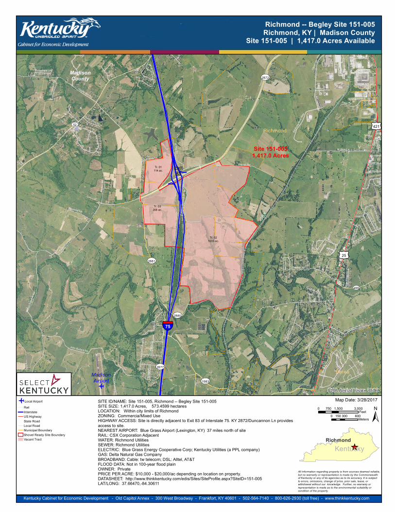
Site 151-0051,417.0 Acres
Richmond
Berea
CSX
§̈¦75
£¤421
£¤25
Tr. 01114 ac.
Tr. 021035 ac.
Tr. 03268 ac.
FSA Aerial Year: 2016
Kentucky Cabinet for Economic Development - Old Capitol Annex - 300 West Broadway - Frankfort, KY 40601 - 502-564-7140 - 800-626-2930 (toll free) - www.thinkkentucky.com
0 1,500 3,000750 Feet0 300 600150 Meters
Richmond -- Begley Site 151-005Richmond, KY | Madison County
Site 151-005 | 1,417.0 Acres Available
o Local AirportRailInterstateUS HighwayState RoadLocal RoadMunicipal BoundaryShovel Ready Site BoundaryVacant Tract
Map Date: 3/28/2017
_̂Richmond
Kentucky
All information regarding property is from sources deemed reliable, but no warranty or representation is made by the Commonwealthof Kentucky or any of its agencies as to its accuracy. It is subjectto errors, omissions, change of price, prior sale, lease, orwithdrawal without our knowledge. Further, no warranty orrepresentation is made as to the environmental suitability orcondition of the property.
±SITE ID/NAME: Site 151-005, Richmond -- Begley Site 151-005SITE SIZE: 1,417.0 Acres, 573.4599 hectaresLOCATION: Within city limits of RichmondZONING: Commercia/Mixed UseHIGHWAY ACCESS: Site is directly adjacent to Exit 83 of Interstate 75. KY 2872/Duncannon Ln providesaccess to site.NEAREST AIRPORT: Blue Grass Airport (Lexington, KY) 37 miles north of siteRAIL: CSX Corporation AdjacentWATER: Richmond UtilitiesSEWER: Richmond UtilitiesELECTRIC: Blue Grass Energy Cooperative Corp; Kentucky Utilities (a PPL company)GAS: Delta Natural Gas CompanyBROADBAND: Cable: tw telecom; DSL: Alltel, AT&TFLOOD DATA: Not in 100-year flood plainOWNER: PrivatePRICE PER ACRE: $10,000 - $20,000/ac depending on location on property.DATASHEET: http://www.thinkkentucky.com/edis/Sites/SiteProfile.aspx?SiteID=151-005LAT/LONG: 37.66470,-84.30611